
Abstract
We report a tephra deposit in the southern Lake Titicaca Basin, Bolivia, which was deposited by a major, previously unrecognized eruption sometime between AD 400 and 720. Archaeological data suggest these centuries were characterized by a substantial community migration to Tiwanaku, where social interaction networks gave birth to one of the Andes’ first large complex societies. Here we provide an initial characterization of this tephra, based on samples from the archaeological site Khonkho Wankane. The same tephra is present at two other archaeological sites in the region. Given the great distance to the nearest active volcano, this tephra layer likely derives from a large-magnitude, Late-Holocene explosive eruption of a Central Andean volcano. We suggest that this major event be included in the human history of the region, given its inferred magnitude and wide dispersal area. Future research could confirm the Khonkho tephra at other sites, identify the source volcano, estimate its volume, and more precisely date the eruption.
Keywords
Introduction
Volcanic eruptions can have devastating effects on human populations (Cashman and Giordano, 2008; Riede, 2019; Torrence, 2019). In the Lake Titicaca Basin, the impacts of volcanic eruptions have been given little consideration, likely because the nearest Holocene volcano is about 140 km away; most are over 250 km away (Figure 1a). Significant tephra deposition at archaeological sites at these distances suggests an explosive eruption of sufficient magnitude to impact human societies. Stratigraphically, the Khonkho tephra was probably deposited between AD 400 and 720 (see below), when Tiwanaku was growing into one of the Andes’ first cities. This report provides conclusive evidence of a distal tephra layer in the Lake Titicaca Basin; however, the source of this eruption remains unidentified.
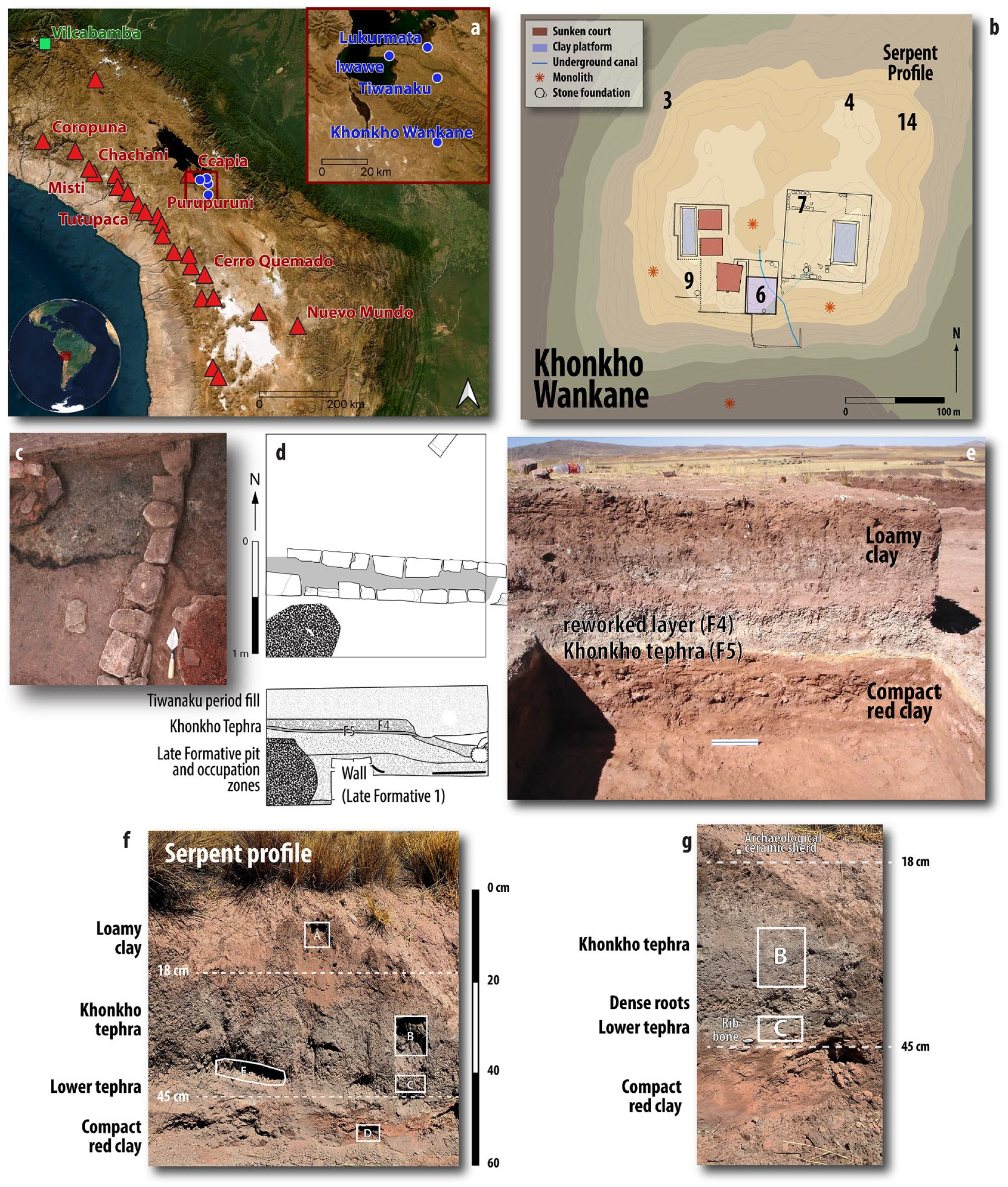
(a) Location of archaeological sites (blue circles and inset), Holocene volcanoes (red; triangles; see Table 2) that could produce sufficiently voluminous eruptions for ashfall to reach the southern Lake Titicaca Basin (inset), and the Vilcabamba peat core (green). Basemap is the Sentinel-2 cloudfree mosaic. (b) Map of Khonkho Wankane, showing major architectural features atop a human-built mound of clay and sand. Numbers indicate excavation sectors where excavations identified the Khonkho tephra (Table 1) and the recently sampled Serpent profile. Contour lines every 1 m; contour shading every 2 m. (c). Plan view of Khonkho tephra in sector 4, unit 18, where the greenish-gray ash lies below Tiwanaku period structure foundations (Janusek et al., 2018: Figure 11.7). Trowel indicates north and approximates scale. (d) Line drawing of sector 14, unit 1 (plan view and west profile; Ohnstad, 2007), where the tephra is above a Late Formative structure foundation. See profile photo in Supplemental Material 2. (e) Sector 9, unit 29, north profile (Zovar, 2006), showing site stratigraphy with tephra deposit. Scale bar measures 10 cm. See plan view in Supplemental Material 2. (f) Serpent profile from a road cut along the northern edge of the mound, showing the location of samples A–E and depths below the surface. Photograph has minor lens distortion and was taken after samples were removed, which obscures sediment changes in places. (g) close-up of (f), taken before sampling, showing clear sediment and soil contacts.
List of similar excavated contexts from Khonkho Wankane that likely represent the same tephra (strata F4 and F5; see locations in Figure 1b)
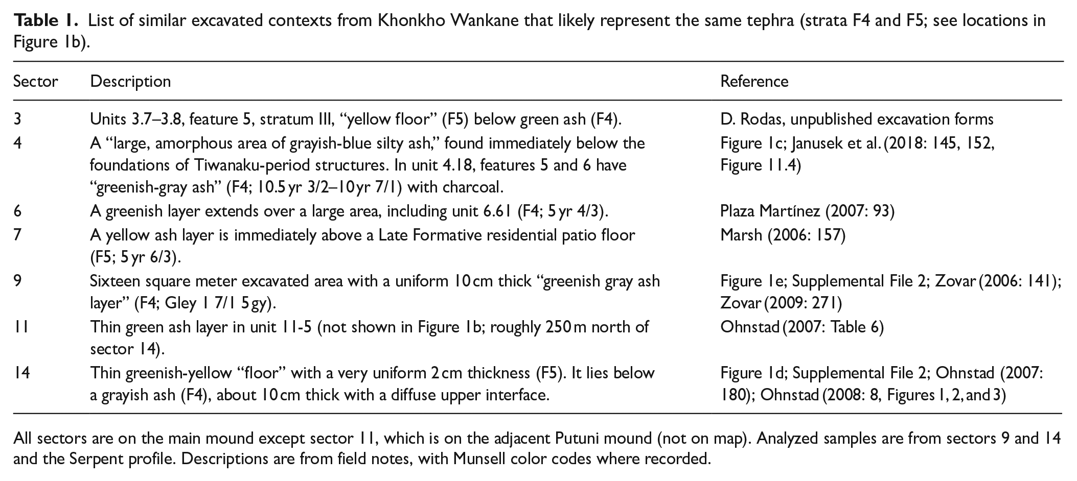
All sectors are on the main mound except sector 11, which is on the adjacent Putuni mound (not on map). Analyzed samples are from sectors 9 and 14 and the Serpent profile. Descriptions are from field notes, with Munsell color codes where recorded.
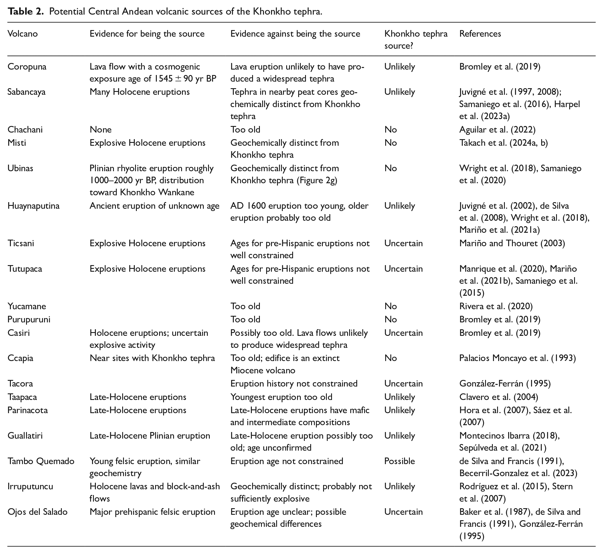
Potential Central Andean volcanic sources of the Khonkho tephra.
An elusive tephra
In the 1990s, volcanologists and archeologists identified a potential tephra layer at the archaeological site Iwawe (Figure 1a) and suggested it was evidence of a major regional eruption (Burkholder, 1997: 87; Isbell and Burkholder, 2002: 212). However, the deposit was not characterized and archeologists remained skeptical of its identification as a tephra because there are no nearby active volcanoes. For this reason, eruptions are not part of the region’s current ecocultural history (Isbell and Silverman, 2006; Janusek, 2004, 2008; Stanish et al., 2005; Vranich et al., 2012; Vranich and Levine, 2013; Vranich and Stanish, 2013).
In the 2000s, excavations at Khonkho Wankane (Figure 1a) exposed an extensive, fine-grained layer that is clearly distinct from adjacent deposits (Zovar, 2009: 371). Initially, the deposit had only been documented in one part of the site, suggesting to Janusek (2009: 171) that it represented a cultural event, perhaps combustion ash created by large-scale burning to prepare for feasts or rituals. At nearby Tiwanaku (Figure 1a), there are extensive pits with analogous, fine-grained deposits (Janusek, 2009: 272). These pits with greenish material are characteristic of Tiwanaku and other Tiwanaku-period sites in the region. Some speculated that the deposit was ash from burning llama dung, an important fuel source for the region. However, a field test confirmed that the color of combustion ash from camelid dung is similar to other organic fuel sources, which ranges from achromatic to shades of brown (Goodman-Elgar et al., 2024). Others suggested that such an ash-like deposit could be from firing pottery; however, high-temperature firing produced white to light-gray ash (Roddick and Cuynet, 2021: 1158).
In 2017, volcanic glass shards were identified in samples of the ashy deposit at Khonkho Wankane (Charles Stern, personal communication), but they were not geochemically characterized. Here, we provide conclusive evidence that this layer is in fact a tephra, which we informally call the Khonkho tephra. Volcanic ash comprises inorganic glass shards, minerals, and rock fragments and is fundamentally different from organic, combustion-derived ash normally found at archaeological sites. We present analyses of samples of the greenish ash, evaluate its stratigraphic position at the site Khonkho Wankane, and compare it to similar deposits in the region. We suggest that this tephra represents a major eruption that may have played a significant role in the histories of human–volcano interactions in the region.
An extensive tephra at Khonkho Wankane
The main human occupation of the site was ~AD 120–420 (estimated as medians of boundaries from Bayesian models of radiocarbon dates; see Marsh, 2016). The site features monolithic sunken courts, carved monoliths, large residential complexes, and an underground canal (Figure 1b; Janusek, 2015; Marsh, 2016; Marsh et al., 2019). Extensive excavations in 2001–2008 revealed ashy layers that consistently crop out throughout the site (Figure 1): a greenish-gray layer (layer F4, Figure 1e) that usually overlies a thinner, 2 cm-thick yellow layer (layer F5, Figure 1e). The yellow layer is of uniform color and texture; it has a clean stratigraphic break with the reddish clay-rich sediment below (Figure 1c). These layers drape the paleotopography of the underlying mound, indicating a single deposition event. Most of the mound is a human-made construction of clay and sand that rises 10 m over the surrounding plain, a high point in the area, reaching its current height around the fourth century AD (Janusek, 2015). These layers are present in six locations in the mound separated by up to 200 m (Figure 1b; Table 1), in a profile of the northern edge of the mound, and on another mound to the north.
Since these layers were not previously identified as a tephra, excavators have described them differently, but all accounts share four features: (1) they uniformly cover underlying deposits and are cut by later human refuse deposits and pits; (2) in many places, there are two layers: a thinner yellow one below a thicker greenish-gray one; (3) there is a near or total absence of artifacts within them; and (4) stratigraphically, they lie between diagnostic Late Formative ceramics (Kalasasaya red-rimmed vessels) and Tiwanaku-period redwares. These depositional characteristics are consistent with an ashfall deposit.
All samples are from the reworked greenish-gray layer (F4, Figure 1d), since samples from the lower yellow layer (F5) were not available for analysis. They were selected because they are from opposite sides of the site (Figure 1d and e). The first sample (9-23-3) is from sector 9, unit 23, level 3, just above the stone foundations of a Late Formative circular structure, 5 m northeast of the profile shown in Figure 1e. The second (14-6-MT001) is from the southern profile of sector 14, unit 6, at a depth of 42–50 cm, excavated as context 14-6-8. Additionally, three samples were analyzed from a road cut, labeled the Serpent profile, for the unusual appearance of a small snake during fieldwork (KW_Vibora_A, KW_Vibora_B, and KW_Vibora_C; Figure 1b, f, and g). We targeted the basal tephra layer during field work but, after analysis, concluded that these lower tephra samples are not from the inital ashfall, but from the reworked F4 layer.
Microanalysis of bulk samples reveal they are all typical of fine-grained (medium sand to clay) regional arid soils (e.g. Kemp et al., 2006; Senra et al., 2019). Quartz and plagioclase are common and occasional rock fragments and scarce K-feldspar, biotite, and apatite are present (Figure 2). The largest grains are sub-angular to sub-rounded while the smaller grains are angular to sub-angular. Biotite has its typical perfect cleavage. The silt and clay fractions are consistent with an aeolian input (e.g. Zárate, 2003, 2007; Zárate and Blasi, 1993). Phytoliths are common (Figure 2c and e), while subfossil plant material is rare and charcoal was not identified. Loss on ignition analysis for two samples yielded organic contents of only 6.2–7.7 wt.%.
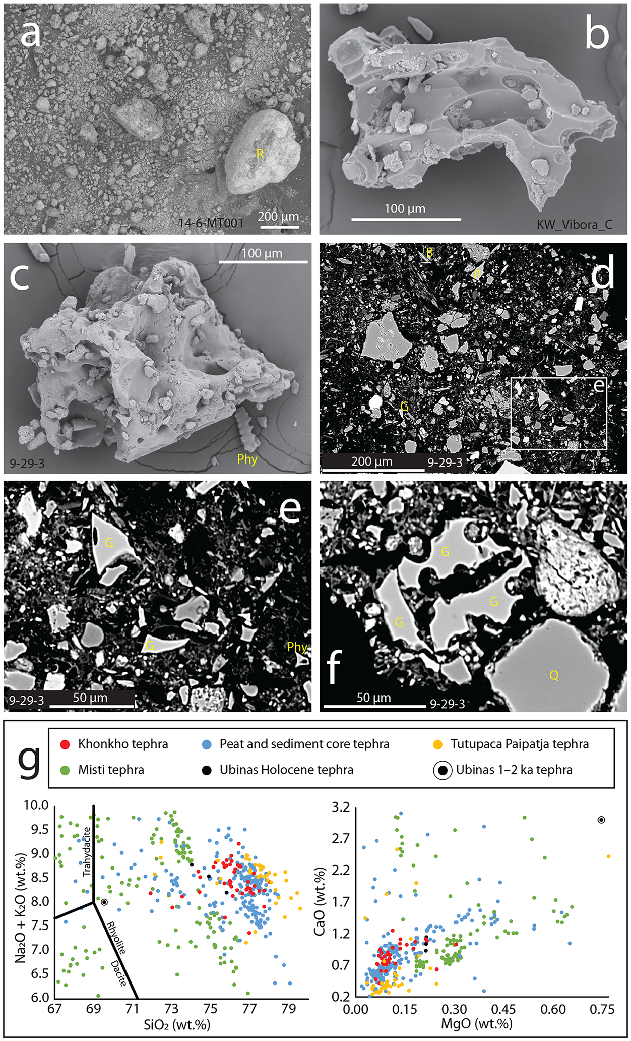
Representative images and geochemical data for the Khonkho tephra (see full data in Harpel et al., 2024). Particles are labeled in the images as G (glass), Bt (biotite), P (plagioclase), R (rock fragment), Q (quartz), and Phy (phytolith). Sample numbers are indicated in the figures. (a) Scanning electron microscope (SEM) secondary electron image of a bulk sample of the Khonkho tephra showing its diverse grain sizes and abundant silt- and clay-size (<63 μm) material. The large, rounded particles are rock fragments and reworked crystals. (b and c) SEM images of glassy, slightly pumiceous ash shards that have cuspate edges formed by ruptured vesicle walls. (b) Has sharp edges whereas the edges of (c) are slightly chipped, possibly from minor reworking. (d–f) SEM backscatter electron (BSE) images of bulk samples of the Khonkho tephra. (e) Closeup of the area indicated by the white box in (d) with two platy glassy shards. Note the clean, non-chipped edges of both shards. (f) Typical pumiceous glassy shard(s) with ruptured vesicles and edges that are chipped in some places. (g) Total alkali-silica diagram with compositional classifications (after Le Bas et al., 1986) and CaO versus MgO bivariate plot of glass chemistry from the Khonkho tephra and tephra from other regional volcanoes. Despite some scatter, data from the rhyolitic Khonkho tephra are compositionally distinct from documented tephra from regional volcanoes and tephras from unidentified sources in regional peat and sediment cores: tephra glass compositions from peat and sediment cores from Juvigné et al. (1997, 2008), and Harpel et al. (2023a); the AD 1787–1802 Paipatja eruption of Tutupaca from Manrique et al. (2020); Misti’s late Pleistocene and Holocene eruptions from Tepley et al. (2013) and Takach et al. (2024a, b); and Ubinas’s Holocene eruptions from Samaniego et al. (2020).
Microscopic analysis, however, additionally shows that all the samples contain sparse, non-altered, platy and pumiceous volcanic glass shards (Figure 2b–f). Glass shards are clear to white, fine to very fine ash size, microlite free, and often have sharp edges formed by ruptured vesicles, though sometimes edges are slightly chipped (Figure 2c and f). Micropumice in sample KW_Vibora_C are slightly larger than shards in other samples and contain phenocrysts of a black Fe-Mg mineral. Vesicles are tube-shaped, stretched and round to sub-round. The glass chemistry is high-K rhyolite (following Le Bas et al., 1986; Le Maitre et al., 2002) with 73.51–78.00 wt.% SiO2, 3.98–7.24 wt.% K2O, and 7.38–9.22 wt.% Na2O + K2O (normalized; analytical details and data in Harpel et al., 2024). Non-normalized totals for glass analyses are 91.04–99.44 wt.%, indicating minimal hydration and weathering. Rhyolitic glass composition, very fine grain size, and shard morphology are typical of distal tephra from large-magnitude explosive eruptions, while the minimally abraded shard edges indicate that the tephra was not significantly reworked (Heiken and Wohletz, 1985). Despite some scatter, the data cluster (Figure 2g) sufficiently to be consistent with a single eruption.
These data suggest that the samples represent a reworked distal tephra-fall deposit and locally derived materials, meaning the yellow F5 stratum might be the primary tephra-fall deposit, though it remains unsampled, and should be a focus of future work. The overlying reworked green-gray layer formed as the primary tephra was intermixed with the soil developing upon it. The fact that both strata are undisturbed in most parts of the site suggests that residents left the site immediately and abandoned it for multiple generations.
Tephrochronology of the Khonkho tephra
Tephra deposits present at multiple sites can be used as chronostratigraphic markers across large regions (Lowe, 2011). We compare the green-gray portion of the Khonkho tephra deposit to similar deposits at two other archaeological sites: Iwawe and Lukurmata (Figure 1a). Notably, descriptions from both sites report a roughly equivalent thickness, color, and absence of artifacts in the tephra layer. The sites are separated by 40 km, suggesting that this was probably a regionally significant event.
The Khonkho tephra was emplaced sometime in the range AD 400–720, mostly overlapping probably during the Terminal Late Formative cultural phase (Marsh et al., 2019). The stratigraphic position of the tephra layer hints that the eruption took place in the earlier part of this temporal range. At Khonkho Wankane, the last residential occupation before the eruption took place was ~AD 400 (340–450, 95%, calibrated and modeled dates) based on two nearly identical radiocarbon dates from sector 7 (AA-66957 and AA-66958; Marsh, 2016). The 10–15 cm thick layer immediately overlies this occupation, so the eruption likely occurred shortly after. There is no evidence for subsequent occupation at the site until the Tiwanaku period residential occupation in sector 4 (Janusek et al., 2018), dated to AD 790 (680–890, 95%; AA-66952). Just downslope from this sector, we dated a rib bone from the Serpent profile (Figure 1g), which returned a calibrated date of AD 720 (670–780, 95%; OS-176076, 1300 ± 15 BP; 13C/12C ratio not reported; for collagen extraction methods, see Tuross et al., 1988). We suspect that this bone came from Tiwanaku-period residential refuse and washed down sometime after the ashfall, meaning it is probably part of the reworked F4 layer.
At Iwawe, a burial was dated to ~AD 820 (680–960; 95%, no laboratory code), which was placed long after the ashfall (stratum IV; Burkholder, 1997: 256; Isbell and Burkholder, 2002: 223). Here, the deposit we suspect is the tephra layer matrix is a “fine, friable soil of a distinctive gray-green color. . . It can be as thick as 25 cm, but is often no more than 10–15 cm” (Isbell and Burkholder, 2002: 211–212). At Lukurmata, the deposit we suspect is the tephra is a 3–5 cm thick layer of “homogeneous gray ash of unknown origin” that “differed completely from any of the natural or cultural deposits found elsewhere at the site” (Bermann, 1990: 245, 303). This layer was deposited about the same time as the occupation of structures 25–28. It overlies structures 14–18, ~AD 470 (360–590, 95%; SMU-2118), and underlies structure 29, ~AD 750 (630–890, 95%; ETH 3377).
The tephra is not present at all archaeological sites, especially where occupations were continuous and residents may have removed or disturbed it. In contemporary ceramics at some sites, potters used volcanic ash as temper (Roddick, 2009: 314–318, 2015: 144). This temper could have been from the Khonkho tephra, but testing this possibility requires future geochemical comparisons.
Possible volcanic sources for the Khonkho tephra
The source of the Khonkho tephra was likely a large-magnitude explosive event, but the source volcano has yet to be identified (Table 2). The Khonkho tephra distribution, thickness, grain size, and high-K composition are consistent with a Central Andean volcanic source (e.g. Rivera et al., 2017, 2020; Samaniego et al., 2020), so we can eliminate all non-Central Andean source events (e.g. Dull et al., 2001; Smith et al., 2020). The closest Holocene volcanoes are ≥140 km (Figure 1) from the site, and prevailing winds often distribute tephra west and southwest, away from Khonkho Wankane (e.g. Harpel et al., 2021; Legros, 1998, 2001). Large-magnitude explosive eruptions, however, can distribute tephra thousands of kilometers (e.g. Adams et al., 2001; Dull et al., 2001; Sarna-Wojciki et al., 1981) and even a short-lived, small-magnitude event, such as the 2019 Ubinas eruption, can cause ashfall in the region where Khonkho Wankane is located (Aguilar et al., 2019).
Few Central Andean volcanic events are precisely dated, though many Holocene eruptions have occurred (de Silva and Francis, 1991; Siebert et al., 2010) and some are recorded in ethnographic literature (Bandelier, 1906; Chávez, 1992; Masse and Masse, 2007). In the 1940s, local Aymara groups were aware of both Misti and Ubinas, despite their distance to Lake Titicaca (Tschopik, 1951: 194). Misti, Ubinas, and some other Central Andean volcanoes, however, can be eliminated as the source of the Khonkho tephra (Figure 2g, Table 2). Many potential sources remain, as Central Andean eruptions continue to be recognized, dated, and geochemically characterized (e.g. Harpel et al., 2023b; Rivera et al., 2020).
Many Holocene-age tephra layers have been identified in peat and sediment cores from the Andes and beyond, although the source volcanoes for many of these tephras have yet to be identified (Harpel et al., 2023a; Hartman, 2018; Juvigné et al., 1997, 2008; Toohey and Sigl, 2017). None correlate geochemically to the Khonkho tephra (Figure 2g), though some were emplaced about the same time. A cryptotephra from the Vilcabamba region (Schweinsberg, 2013) was emplaced ~AD 410 (330–480, 95%), according to a new age depth model (Supplemental File 1). However, it has blocky shards, dark green to black glass, and is enriched in CaO and MgO (derived from energy-dispersive X-ray spectroscopy analysis), suggesting a more mafic composition than the Khonkho tephra. A felsic ash layer at about 80 cm depth in the Lake Chungará cores is Si-rich and Fe-deficient (based on X-ray fluorescence analysis; Guédron et al., 2019), similar to the Khonkho tephra. Future comparisons and possible correlations to this and other tephra deposits will require analyses using identical methods for all samples and could be bolstered by consideration of additional volcanic eruption tracers, such as excess sulfate, sulfate isotopes, thallium, and fluoride (Kellerhals et al., 2010; Ramirez et al., 2003).
Consequences of a major eruption on human–environment interactions
The societal impact of an eruption should correlate with eruption magnitude (Riede, 2019). Looking at the preserved tephra layer at Khonkho Wankane, it is reasonable to assume that the tephra deposit thicknesss was a few centimeters at minimum, based on the thickness of the basal yellow layer (F5) and the reworked layer (F4, and the tephra unit in the Serpent profile), which is a few tens of centimeters thick. Tephra fallout of this scale is characterized by immediate onset and extensive spatial coverage, meaning rapid environmental change, and would have disrupted daily, seasonal, and annual rhythms, perhaps radically (Burkholder, 1997; Leroy, 2006). Even the minimum tephra thickness estimate would have a profound impact on the delicate ecology of the arid altiplano, directly affecting camelid herds, water sources, agricultural fields, and gardens (Zeidler, 2016).
The impacts of ashfall to agricultural production depend strongly on seasonality and crop type; however, partial smothering (which inhibits photosynthesis) and crop spoilage would be the expected minimum for the Khonkho tephra, with burial of pasture and most crops likely (Jenkins et al., 2014; Riede, 2019). Furthermore, tephra deposition may lead to restricted access or contamination of feed and drinking water for livestock, resulting in starvation and dehydration (Flueck, 2016). In the Khonkho tephra thickness range, abandonment of pastoral land for multiple years, at minimum, is documented elsewhere (Abbott et al., 2012), and the fertility of buried soil may wane over time as key soil processes (e.g. nitrogen and oxygen cycles) are disrupted. Consequences may have been amplified for risk-averse agropastoralists on the arid altiplano, since camelid reproduction rates are low. Anecdotally, alpacas around Sabancaya volcano, Peru, stopped eating during the eruption that started in 2016, even though ashfall accumulation was only a few millimeters (though this has not been quantified). Agricultural recovery is possible after a few years in areas with just a few centimeters of ashfall, particularly with active clean-up and rehabilitation, but thicker ashfalls have increasingly detrimental effects that may last decades or longer (Riede, 2019). This is particularly true given the deposit evidence of extensive tephra remobilization, which could have persisted for many years in the arid climate (Forte et al., 2018).
Social impacts may have been equally severe, and perhaps were related to the depopulation of Khonkho Wankane and other ceremonial centers sometime in the two-century Terminal Late Formative phase. As in other cases of abandonment, natural disasters and political shifts can drive population movements (Abbott et al., 2012; Cameron, 1991). This has precedent for major volcanic eruptions, such as regional abandonment of Maya sites following the Tierra Blanca Joven eruption in AD 431, which measured a 7 on the Volcanic Explosivity Index (VEI) scale (Dull et al., 2001, 2019; Newhall and Self, 1982; Sheets, 1979; Smith et al., 2020). A similar response could be motivated by smaller eruptions, including ones similar in magnitude to the Khonkho tephra’s source eruption, perhaps VEI 4–5, based on the distance to possible source volcanoes. In Ecuador, eruptions of this size preceded three episodes of abandonment. The most recent, around AD 90, led to a centuries-long valley abandonment and a subsequent increase in political complexity (Zeidler, 2016), which might be analogous to the emergence of Tiwanaku. Around the time of the eruption, novel interactions among expanding social groups were the foundation for one of the Andes’s first cities and Tiwanaku’s sprawling and lasting social networks.
Future research and “archaeological volcanology” in Bolivia
The presence of a widespread volcanic ash layer at archaeological sites in the southern Lake Titicaca Basin has been unconfirmed since it was first reported in the 1990s. Based on geochemical data, we confirm that a large magnitude explosive eruption is consistent with the presence of tephra at archaeological sites ≥ 140 km away. We report consistent data from multiple samples at the site Khonkho Wankane, opening the door to “archaeological volcanology” in Bolivia (Riede, 2019). Future efforts could (1) assess past and future excavations to identify other sites with the Khonkho tephra and (2) map the distribution and chemically fingerprinting the tephra, with the goal of identifying the source of the eruption. The deposit serves as a useful regional marker horizon, although it needs to be more precisely dated in order to incorporate into culture histories. Our samples also include phytoliths, which have potential to help understand the eruption’s impact on wild and domestic plants and the region’s raised fields.
We hope these results inspire reexamination and new interpretations of the cultural history of the Lake Titicaca Basin and the impacts from this significant ashfall that took place sometime in the span ~AD 400–720. Around this time, there was a major transgression of Lake Titicaca (Delaere et al., 2023; Guédron et al., 2023), indicating improving environmental conditions that could have helped speed the recovery of fields and pastures. All of this happened during the tumultuous Terminal Late Formative phase, when the city of Tiwanaku swelled with migrants, perhaps motivated to leave their homes by a volcanic eruption and its impacts. These challenges could have motivated more cooperation by larger groups, created denser and more diverse social networks, and even urban genesis. The data reported here are the first tantalizing hints that Tiwanaku may have risen from the ashes.
Supplemental Material
sj-docx-1-hol-10.1177_09596836241275000 – Supplemental material for The Khonkho tephra: A large-magnitude volcanic eruption coincided with the rise of Tiwanaku in the Andes
Supplemental material, sj-docx-1-hol-10.1177_09596836241275000 for The Khonkho tephra: A large-magnitude volcanic eruption coincided with the rise of Tiwanaku in the Andes by Erik J Marsh, Christopher J Harpel and David E Damby in The Holocene
Supplemental Material
sj-pdf-2-hol-10.1177_09596836241275000 – Supplemental material for The Khonkho tephra: A large-magnitude volcanic eruption coincided with the rise of Tiwanaku in the Andes
Supplemental material, sj-pdf-2-hol-10.1177_09596836241275000 for The Khonkho tephra: A large-magnitude volcanic eruption coincided with the rise of Tiwanaku in the Andes by Erik J Marsh, Christopher J Harpel and David E Damby in The Holocene
Footnotes
Acknowledgements
For their work on the archaeological excavation, thanks go to the members of project Jach’a Machaca, including archeologists from Bolivia, Canada, and the United States as well as the local community Qhunqhu Liqiliqi and specifically to community member Luis Mario Melendres Asistiri for identifying the Serpent profile. Thanks to Charles Stern for the initial identification of the tephra and encouragement to pursue more detailed analysis. The manuscript greatly benefited from the reveiwers’ construtive suggestions, discussions with Shan de Silva, and a review by Kristi Wallace. Nelida Manrique and Heather Wright kindly provided geochemical data for comparison. Charles Lewis, Tami Christianson, Erin Lysne, and Nathan Andersen all provided critical help during sample preparation and analysis. Any use of trade, firm, or product names is for descriptive purposes only and does not imply endorsement by the U.S. Government.
Author contributions
Declaration of conflicting interests
The author(s) declared no potential conflicts of interest with respect to the research, authorship, and/or publication of this article.
Funding
The author(s) disclosed receipt of the following financial support for the research, authorship, and/or publication of this article: Excavation of these samples was carried out by the archaeological project Jach’a Machaca, which was funded through grants awarded to John W. Janusek by the National Science Foundation (BCS-0514624), the National Geographic Society (7700-04), the Howard Heinz Foundation, the Curtiss T. and Mary G. Brennan Foundation, and the Vanderbilt University Discovery Grant Program. Tephra analysis was funded by the U.S. Agency for International Development Bureau for Humanitarian Assistance (Award Number 720BHA22H00004).
Supplemental material
Supplemental material for this article is available online.
References
Supplementary Material
Please find the following supplemental material available below.
For Open Access articles published under a Creative Commons License, all supplemental material carries the same license as the article it is associated with.
For non-Open Access articles published, all supplemental material carries a non-exclusive license, and permission requests for re-use of supplemental material or any part of supplemental material shall be sent directly to the copyright owner as specified in the copyright notice associated with the article.