
Abstract
The Holocene infill of an intermittently open-closed barrier estuary (Painkalac Creek/Aireys Inlet) was examined on the southern margins of Australia, through aerial LiDAR, coring, sedimentology, radiocarbon dating and pollen analysis. It is found that almost all the accommodation space within the estuary has been occupied, with a thick sequence (>9 m) of sediments being deposited rapidly soon after flooding by the sea. The rate of sedimentation was 4.8 mm/year which closely matches the rate of sea level rise (4.5 mm/year) during the 1200 year period that the estuary infilled, from around 8000–6800 years ago. The evidence of estuarine deposition above the elevation of the modern intertidal zone provides significant further evidence for the presence of the mid-Holocene highstand sea level in this relatively unstudied part of the Australian coast. The pattern of infill departs from the traditional barrier evolution models. The first phase of infill was likely tide dominated with subtidal sand shoals being found landward of a subtidal bedrock sill. Once a beach-barrier sequence formed, the estuary infilled in a more traditional manner, with lateral progradation of a flood tide delta and central mud basin infill. The barrier estuary of Painkalac Creek therefore has undergone a complex evolutionary history, characterised by a change in process dominance from classic tidal to wave-dominated form. Infill occurred in a keep-up (or fast catch-up) mode, with geological control occurring in regard to the presence of an intertidal bedrock sill at the mouth of the estuary.
Introduction
Barrier estuaries are depositional systems found on wave-dominated coasts. They form during a sea level transgression when a beach-dune sequence is deposited at the entrance of a newly flooded river valley (Dalrymple et al., 1992; Kennedy, 2011). For a barrier to form, the coastline is generally wave dominated, and the shelf slope low enough to encourage onshore sediment transport as sea level rises and/or contains it within shallow water in the subsequent stillstand (Cooper et al., 2018; Davis and Hayes, 1984; Roy, 1984; Roy et al., 1994). The shape of the former river valley will also affect the ability of a barrier to form. Where the basin is hyposychronous the tide is locally enhanced and subaerial accumulation of beach sand is not possible (Dalrymple and Choi, 2007), however in many cases the tidal wave is not enhanced and a barrier can develop allowing for the formation of a low-energy depositional basin.
The pattern and rate of infill of the estuary will be a function of the relative dominance of marine and fluvial processes as well as the rate of sediment supply (Allen and Posamentier, 1993; Kennedy, 2011; Zaitlin et al., 1994). In typical barrier estuaries, marine processes (waves and tides) are spatially restricted to near the estuary entrance, while fluvial influence occurs at the landward edge of the basin (Dalrymple et al., 1992). Through time, the basin infills and the fluvial zone progrades seaward and in doing so the spatial dominance of hydrodynamic process changes (Cooper, 1993, 2001). Catchment geology can also influence estuarine sedimentation through being the primary determinant of the available accommodation space. That is, the longer-term processes of fluvial incision will determine how deep the river valley has incised and therefore how much space is available for sediment accumulation once sea level returns to an elevated position during an interglacial period elevation. Essentially, for a central basin within an estuary to occur, the rate of inundation must exceed the rate of sediment supply, the former being primarily controlled by bedrock morphology and the rate of sea-level rise (Cooper, 1993). The rate of subsequent infill is determined by the boundary conditions of sediment supply and available accommodation space (Cooper et al., 2018).
In south eastern Australia, eustatic sea level has been at or slightly above modern elevation for the past 6000–7000 years (Lewis et al., 2013) and many barrier estuaries are yet to infill, and therefore have available accommodation space. Examples include, Tuggerah Lake (Macreadie et al., 2015), Dee Why Lagoon (Chagué et al., 2019), Minnamurra River (Haslett et al., 2010; Panayotou et al., 2007) and the Illawarra region (Sloss et al., 2005, 2010, 2019). Only a few in this region are infilled today and this has occurred through the progradation of fluvial deltas (e.g. Shoalhaven, Australia (Carvalho and Woodroffe, 2020; Carvalho et al., 2019; Umitsu et al., 2001), Bega, Australia (Oliver et al., 2023)). The same has occurred in the Southern Hemisphere such as northwest Nelson, New Zealand (Kennedy et al., 2022), or South Africa (Cooper, 1993).
Low rates of supply of continental sediment often means that estuaries can still have accommodation space today, despite the systems being flooded by the sea for over 7000 years. In southern Australia, in the state of Victoria, many estuaries are found to be infilled despite the low rates of continental denudation (McSweeney et al., 2017a). It has recently been shown that local geological control can limit the amount of vertical space for estuarine facies to develop (Kennedy et al., 2021). In this paper we describe the sedimentology and infill of the Aireys Inlet/Painkalac Creek estuary, a system which is completely infilled today, but whose surficial morphology suggests a range of degrees of geological control. We explore how this system infilled and whether it, like others in the region, diverge from traditional models of estuary infill during stillstand periods.
Regional setting
The Painkalac Creek estuary is located at Aireys Inlet, on the southern coast of Victoria (Figure 1). The creek has a catchment area of 80 km2 and the estuarine basin is currently infilled to above supratidal elevations, with only the lower 800 m being intertidal and having an open-water body (Figure 2a). The mouth of the estuary maintains an intermittent connection to the open ocean being separated by a sandy beach berm which is closed >40% of the time (McSweeney et al., 2017a, 2017b). An undated barrier dune, 75 m wide, forms the seaward boundary to the estuary rising to an elevation of c. 15 m above mean sea level (Figure 2b).
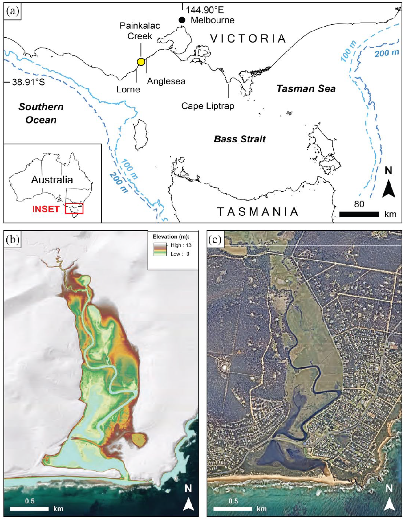
(a) Location of Aireys Inlet/Painkalac Creek in the southeastern part of Australia with (b) a digital elevation model and (c) aerial image of the lower part of the valley. The estuary fronts the northern margins of the Otway Ranges.
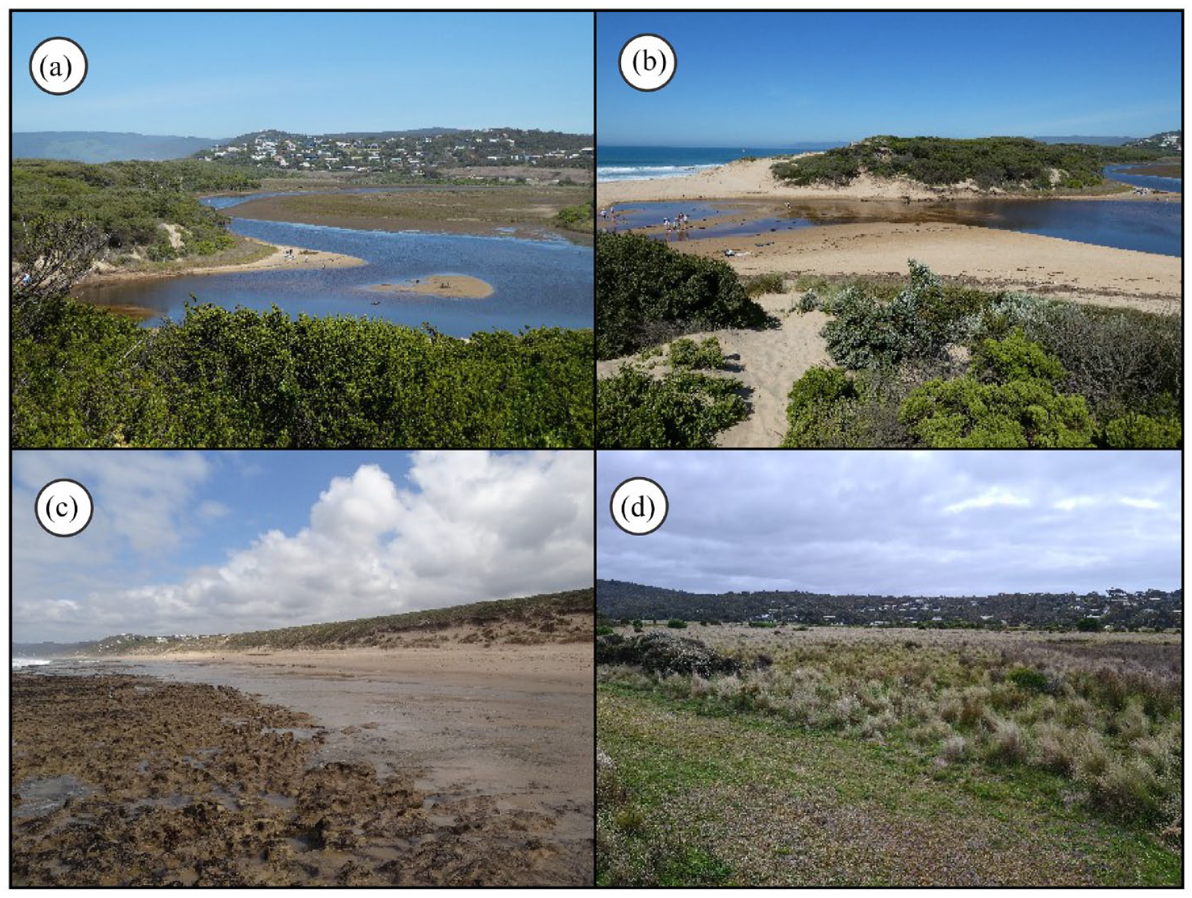
(a) The small open-water lagoon that occurs in the lower most part of Painkalac Creek. (b) The mouth of Painkalac Creek, and the beach-barrier sequence which forms the seaward edge of the estuary. (c) Outcrops of limestone at low tide on the open beach fronting the barrier. (d) The estuarine floodplain in which the coring was undertaken.
The geology of the catchment is dominated by the Eocene Eastern View Formation (EVF) with the older Cretaceous sandstones of Eumeralla Formation found in the uppermost parts of the catchment. The EVF is a variable mixture of fluvial and alluvial sediments containing abundant silts, quartz sands, coals and carbonaceous clays (Hancock, 1967). The lower portion of the estuary, and surrounding the sampling locations, features the Eocene to Oligocene Demons Bluff Group composed of carbonaceous pyritic silt to fine sands, clay and clayey sand occurs (Birch, 2003; Douglas and Ferguson, 1976). At the estuary mouth, an outcrop of the sandy limestone of the Oligocene to Miocene Torquay Group is found (Birch, 2003; Douglas and Ferguson, 1976) and this also outcrops along the open-ocean beach in the surf zone (Figure 2c).
Holocene sea-level in Victoria is considered to be primarily driven by eustatic processes and is most likely similar to that of eastern Australia broadly (Bryant, 1992; Kennedy et al., 2020b; Lewis et al., 2013). A maximum elevation during the Holocene occurred at around +1.0–1.5 m 6000–6500 calibrated years ago (cal BP) has been suggested based on dating of raised notches (Cape Liptrap; Baker et al., 2001; Gardner et al., 2009) and estuarine sediments (Anglesea; Kennedy et al., 2021) in southern Victoria.
Offshore of Aireys Inlet the mean significant wave height offshore exceeds 3.0 m (mean Tp >13.0 s) from the south west (McSweeney, 2020), and the spring tidal range is 1.6 m at Lorne, 25 km to the southwest (PoM, 2013). Storm and modal waves come from the southwest on average (McSweeney, 2020). The climate is temperate with a mean annual precipitation of 623 mm and mean annual temperature range of 10.7°C–18.4°C (Bureau of Meteorology (BoM), 2023).
Methods
The estuary was surveyed using Airborne Light Detection and Radar (LiDAR) in 2007 by the Victorian State Government using a LADS Mk II system coupled with a GEC-Marconi FIN3110 inertial motion sensing system and a dual frequency kinematic global positioning system (kGPS). This dataset was processed to produce a digital elevation model with a final raster grid of 1.0 m resolution (Quadros and Rigby, 2010).
Subsurface sampling was undertaken using a truck-mounted hydraulic power auger and 3.5″ (90 mm) solid augers of 1.5 m lengths. Sediment sampling was conducted at 500 mm intervals down each borehole. A total of five auger holes were bored, each to a depth of 9 m below the surface. The auger holes were supplemented by two sets of push cores taken in 2019 and 2021, manually hammered to depths of 1.05–1.66 m at an additional four locations along the same transect as the 9 m holes (Figure 3). Push cores were taken in adjacent locations in both years.
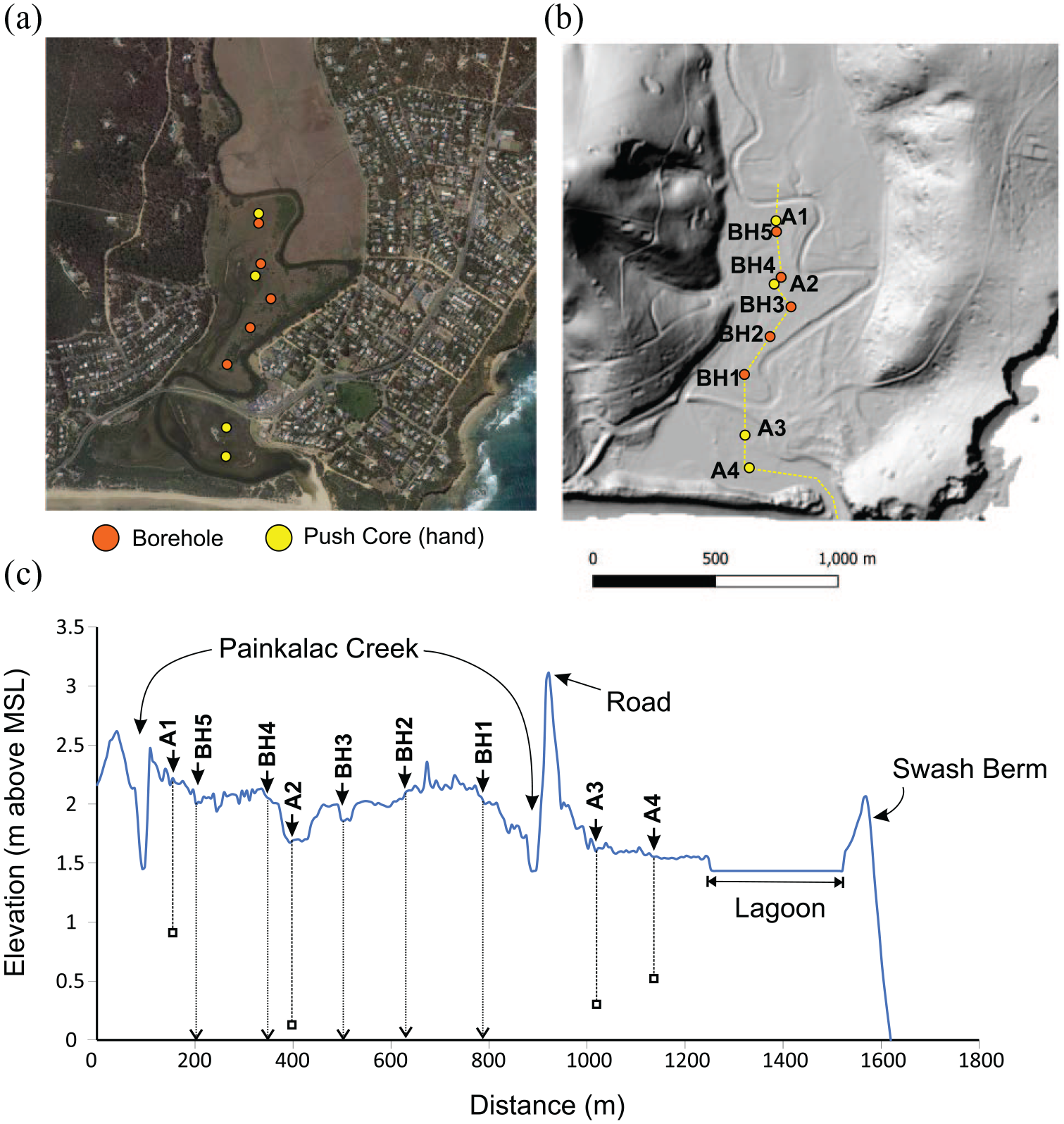
An (a) aerial image and (b) hillshade model of the lower part of the estuary which was the focus of this study showing the location of the power auger (BH1–5) and manual push core (A1–4) sampling sites. (c) A long profile through the sampling sites.
Grain size and pollen analysis was conducted at the School of Geography, Earth and Atmospheric Sciences laboratories at The University of Melbourne. Particle size was measured using a Beckman Coulter 13320 laser sizer. Palynological analysis was undertaken on two of the power auger boreholes using standard protocols (including hot 10% KOH, 40% HF and acetolysis), as outlined in Faegri and Iversen (1989). Organics were separated with KOH and acetolysis, while the fine-sized mineral component was removed using HF and a 7 µm mesh. Pollen and spores were counted to a terrestrial pollen sum between 100 and 300 grains, depending on concentration and preservation of pollen grains. The identification was based on species reference collections held within the School and the Australasian Atlas of Pollen and Spores. Counts were processed and graphed using Tilia 2.0.37 (Grimm, 1999).
Dating was conducted at the University of Waikato Radiocarbon Dating Laboratory, New Zealand. All radiocarbon ages have been calibrated using OxCal v4.4.4 (Bronk Ramsey, 2021) and are reported at the 95% confidence interval as cal BP. A Delta R (∆R) value of 0 based on the ‘Marine20’ curve is used (Heaton et al., 2020). The ∆R values within the Marine20 curve are based on a range of sites from eastern Australia (Gill, 1983; Gillespie and Polach, 1979; Komugabe-Dixson et al., 2016) however as noted by Ulm (2006), variation in marine currents and upwelling along the Victorian and Bass Strait coast mean that east Australian values may not be representative of the Victorian coast. Combined with the uncertainty of ∆R in the mid-Holocene in an estuarine environment, we opted for use of the Marine20 curve rather than applying a more specific local value. The difference between the ∆R corrections on the calibrated ages is however only a maximum of 200 years and therefore does not impact on the millennial-scale focus of this work.
Results
Morphology
LiDAR data
The infilled river valley of Painkalac Creek extends 6.1 km inland from the estuary entrance with the c. 10+ m high Painkalac dam forming an 800 m long lake in its headwaters (Figure 4). The valley floor is flat with the river incised, by up to 4 m along its entire length (Figure 4). The infill can be divided into two broad basins, defined on the basis of floodplain slope. The upper part slopes seaward at 0.5°, while the lower part is nearly horizontal. The boundary between the two areas occurs at an elevation of +5 m above MSL and at a pinch point in the valley where the hills constrict the valley to a width of 200 m as opposed to an average width of 400 m in the upper and lower parts (Figure 4). The lower part occurs at between 1.5 and 2.5 m above MSL and includes the modern estuarine lagoon (Figures 2a,d and 3). This part of the valley is the focus of this study. The landward 1500 m of the study area is at around 2.0–2.5 m above MSL, and the seaward 300 m being at around 1–1.5 m above MSL.
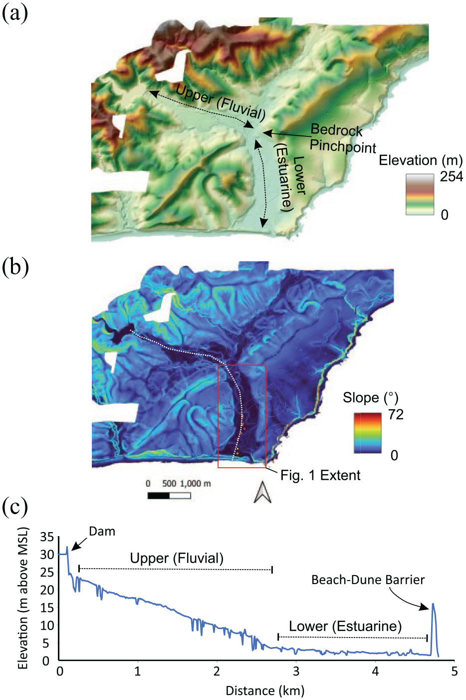
A digital elevation model of Aireys Inlet and the Painkalac Creek catchment, showing (a) elevation, (b) slope and (c) a cross section through the infilled estuary from the open-ocean beach to a dam in the headwaters. The two primary depositional zones (fluvial and estuarine) are delineated on the basis of floodplain slope.
Subsurface sedimentology
Sediments were sampled to 9 m below the floodplain (Figure 5). Silt-size sediment dominates the sequence interrupted by two sand units at 6.5 and 2–3 m depth (Figure 6). The mean size of mud-units is generally between 4.38 and 6.11 φ (coarse to fine silt), extending from the base of the boreholes to 4.0 m depth (−2.0 m from MSL) in BH1-3 shallowing to 3.5 m depth (−1.5 m MSL) in BH5. There is a coarsening (by 2.44 φ) trend in the silts at the landward half of the transect (BH3–5), from 8.0 to 4.5 m (−6.0 to −2.5 m MSL) depth, with the sediments then fining from 4.0 to 4.5 m depth. The silt units are very poorly sorted with values of 2.04–3.04 φ. Overall, there is a positive relationship between size and skewness (R2 = 0.54, p < 0.0001) for the <2.11 φ fraction with the sediment only being fine-skewed once the size is finer than 4.0 φ, and near-symmetrical when the grains are finer than 5 φ (Figures 6 and 7).
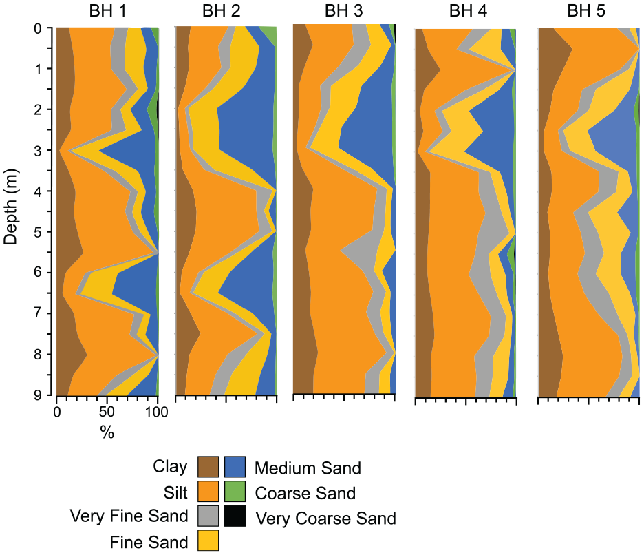
Downhole sedimentology of each of the 9 m deep power-auger boreholes. The boreholes are plotted at their respective heights above mean sea level.
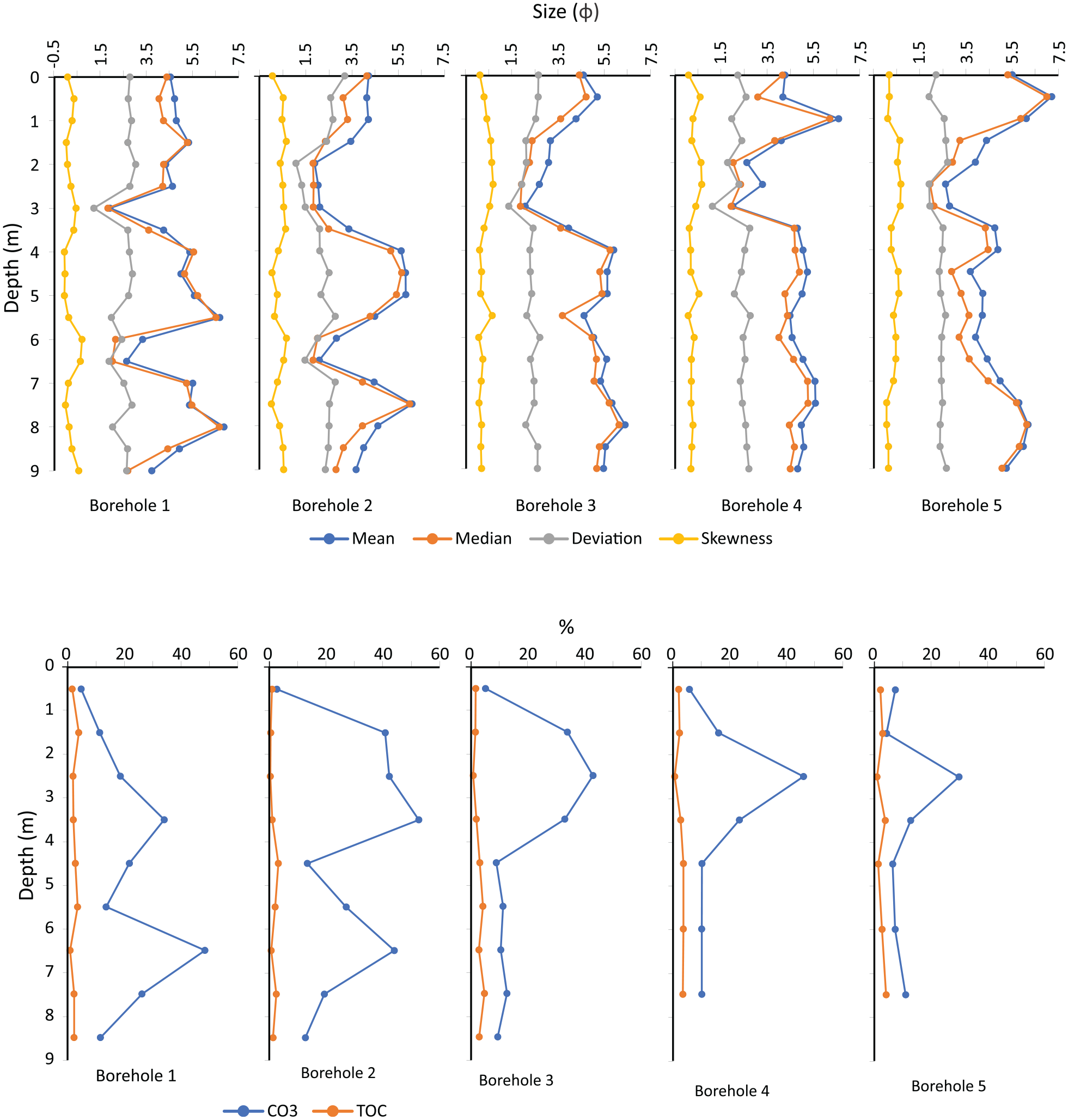
Textural characteristics of each power-auger borehole and the composition of total organic carbon (TOC) and carbonate (CO3).
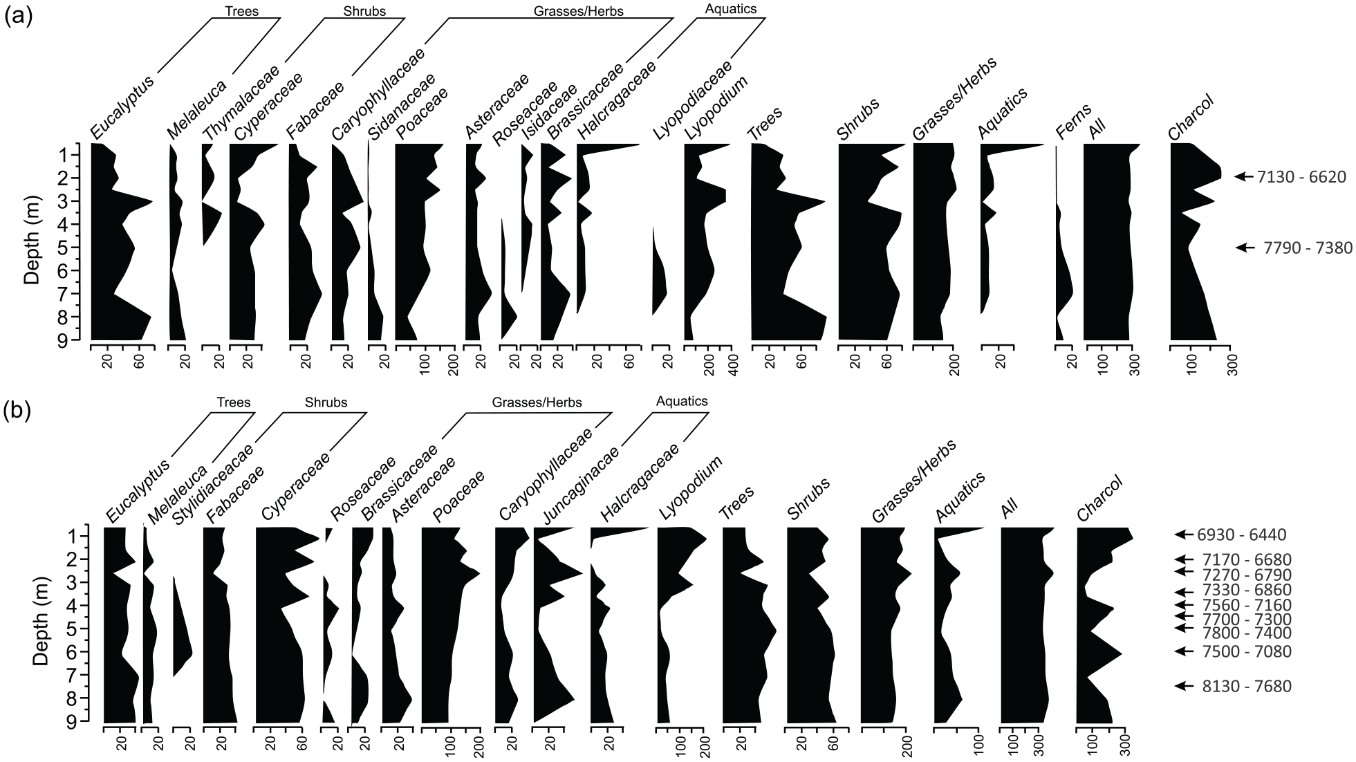
Palynology of (a) borehole 1 and (b) borehole 3 showing the variation of palynomorphs and charcoal composition through time. Each of the radiocarbon ages is in cal BP.
Two distinct sand units occur at the seaward edge of the transect at 6.5 and 3.0 m depth (−4.5 to −1.0 m MSL; BH 1 and 2) with the lower unit becoming less distinct with distance inland (Figures 5 and 6). The lower unit is 1.0 m thick and is composed of a poorly sorted fine sand. The sandy unit does not continue further inland as it is not found in BH3, however the sediments do coarsen over a 0.5 m interval to a coarse silt (5.5 m depth in BH3) and 4.5 m depth in BH5. The lower unit has a peak calcium carbonate content of 48.4% in BH1, the highest in the borehole, decreasing to 44.6% in BH3. Visual inspection of the lower sand indicates it contains abundant mollusc shell fragments.
The upper sand unit is thinnest in BH1 (0.5 m) thickening to 2.0 m in BH2 and 3, before again thinning to 1.0 m in BH5 (Figures 5 and 6). It is composed of a poorly sorted (1.10–1.92 φ) medium sand (mean 1.84 φ) fining to a fine sand (mean 2.77 φ) at its landward edge in BH5. It is also strongly finely skewed throughout the estuary (0.46–0.67 φ; Figure 6). Broken shell fragments are common throughout the unit and it contains up to 29.8–52.7% carbonate material.
The top of the upper sand unit was encountered in the manual push cores that penetrated to a maximum depth of 1.66 m. These cores provide a visual parameterisation of the upper 1.5 m of the estuarine plain, not able to be discerned in the power auger sampling. Overlying the sandy unit homogeneous fine muds occur, which are distinctly iron stained at PC2, located between BH3 and BH4. The upper 0.5 m of the push cores tends to be more stained by humic material and root penetration is visible from a thin soil layer that extends to around 0.2 m depth.
An oxidised orange coloured unit extends to the active salt marshes at the end of the contemporary estuarine water body. Here the sediments are much sandier, with clayey sediment in the middle part of the core (0.6 m depth) and mud-couplets in the lower sections. Marine shells are abundant from 0.6 m to the base of the cores at 1.3 m depth along the transect. The sandy, oxidised, unit in from 0.3 to 0.7 m depth next to the water appears devoid of macro-shell material.
Pollen
Palynological analysis was undertaken in Boreholes 1 (close to the modern estuary) and 3 (in the centre of the transect) with well-preserved palynomorphs found throughout the sequence. At the base of the cores the vegetation was dominated by tree and shrub species, particularly Eucalyptus and Cyperaceae species respectively. Both vegetation types were dominant throughout the borehole, with Eucalyptus decreasing in abundance towards the surface in BH1 but being more constant in BH3. In both cores, the pollen concentrations were more variable in the upper 4 m. Grasses and herbs increased gradually throughout the core, with Poaceae species became more abundant in the ecological assemblage towards the surface. The most significant change in the assemblage occurs in the aquatic species, represented by Haloragaceae (water milfoil), Lycopodiaceae (clubmoss, firmoss) and Juncaginaceae (arrowgrass). These were present in the lower half of the BH3 borehole but decrease in abundance in their centre. A marked increase in the assemblage of aquatic species was then found in the upper 1 m of the borehole in both BH1 and BH3 concomitant with an overall reduction in tree pollen. Exotic pollen, such as Pinus radiata, was absent from the boreholes.
The presence of charcoal is often used as a proxy for past fire regimes in Australia (Mooney et al., 2011). Charcoal was found in abundance throughout the sequence. In both boreholes it has the highest proportion at the top and base of the sequence decreasing towards the middle. In BH3 it was in greatest abundance at the surface, having progressively increased in abundance from around 3.5 m depth. In BH 1, the highest charcoal concentration was found at around 2 m depth and rapidly decreases towards the surface.
Chronology
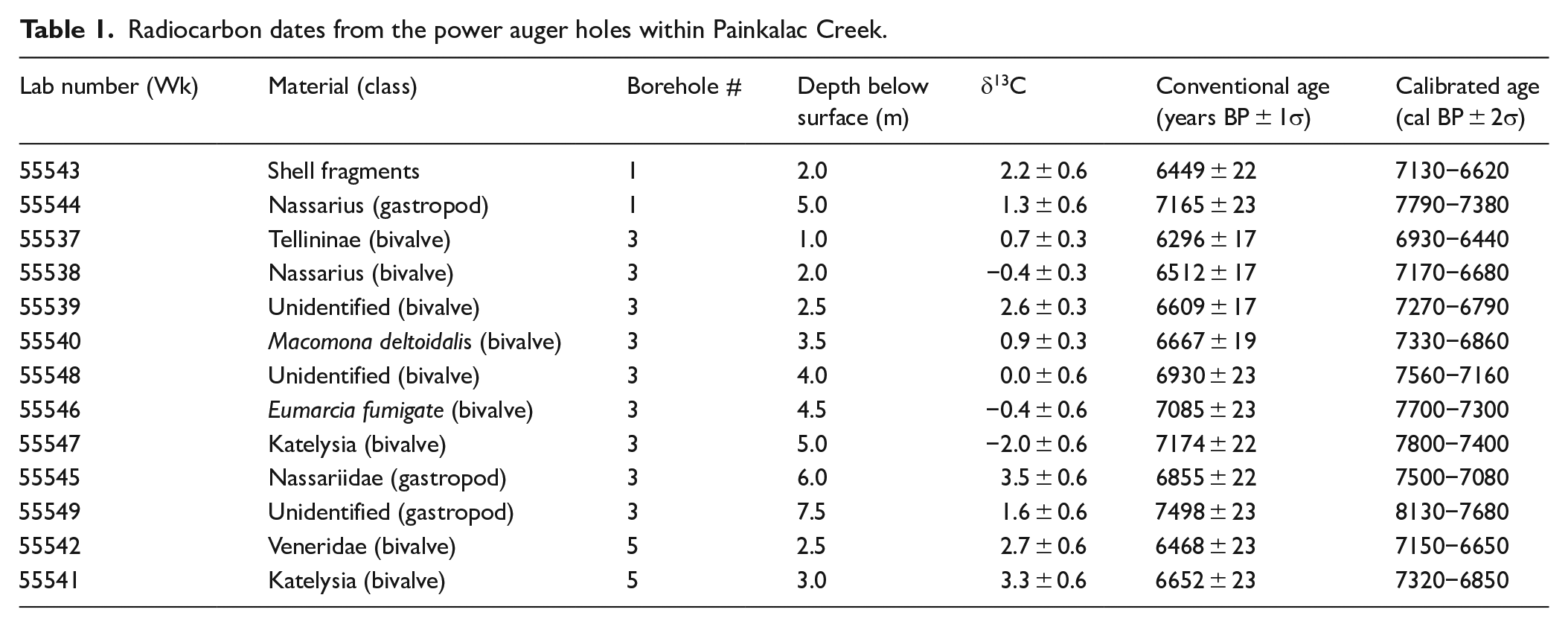
Thirteen AMS radiocarbon ages were obtained from mollusc material recovered throughout BH1, 3 and 5 (Table 1). All the molluscs were reworked, however those with the least breakage and alteration through water-rounding were preferentially selected for dating. The nature of the power auger sampling meant that it was not possible to determine whether any of the samples were in growth position. However, the mollusc shells yielded progressively older radiocarbon ages with increasing depth. The deepest sample was an unidentified gastropod (Wk-55549) at 7.5 m depth in BH3 and returned the oldest radiocarbon age of 8130–7680 cal BP. Similarly, the shallowest sample was a Tellininae bivalve fragment (Wk-55537), at 1.0 m depth in BH3 and returned the youngest radiocarbon age of 6930–6440 cal BP. This remarkably linear trend in age-depth relationships (r2 = 0.84), suggests a uniform rate of accretion throughout the estuary of 4.8 mm/year (Figure 8), which saw the estuary infill within 1200 years, between approximately 8000 and 6800 years ago. One radiocarbon age determination lies outside of trend, the sample of the gastropod Nassariidae at 6.0 m depth in BH3 (Wk-55545: 7500–7080 cal BP). The δ13C for this shell was 3.5 ± 0.6‰, which is substantially higher than the δ13C values reported for the two other dated shells of this family (Wk-55544, Wk-55538; −0.4 ± 0.3‰ and 1.3 ± 0.6‰). This suggests that the 6.0 m BH3 sample has undergone some postmortem changes in chemistry, or that the feeding pattern of the gastropod meant its carbon absorption was not in equilibrium with the surrounding seawater. Alternatively, this sample may have intruded into lower depths as a result of post-depositional factors such as animal (e.g. crab) burrowing or root tunnelling. Excluding this age from the linear regression leads to be correlation coefficient increasing to 0.96.
Radiocarbon dates from the power auger holes within Painkalac Creek.
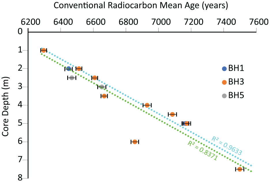
The age–depth relationship of the radiocarbon ages (in conventional years BP) with depth within the boreholes BH1, 3 and 5. An almost linear trend of deposition occurs with the estuary infilling within a 1200-year period. The green line is the entire dataset while the blue line excludes the outlining date at 6 m depth.
Discussion
Infill and sea level change
The Painkalac Creek estuary is currently infilled with sediment, with only a shallow (<2 m deep) open water body occurring in the lower 850 m of the system today (Figure 1). Based on the available data, a sedimentation rate of 4.8 mm/year has been assessed with the basin infilling in a relatively short period (1200 years) coinciding with sea level reaching present position at the end of the Post Glacial Marine Transgression elsewhere in Australia (Lewis et al., 2013). The rate of infill is close to that of the rate of sea level rise in eastern Australia from current elevation to its height during the mid-Holocene maxima (4.8 mm/year vs 6 mm/year), and just higher than that predicted from GiA modelling (4.5 mm/year from 9.0 to 7.5 ka; Goodwin et al., 2023) (Figure 9) but lower than the rate of 8.3 mm/year between 8150 and 7550 cal BP found in NSW barrier estuaries (Sloss et al., 2007). The rate of infill in Aireys is higher than that of the adjacent Anglesea Inlet (3.87 mm/year, between 6700 and 6300 cal BP), 10 km to the northeast. The timing of infill therefore suggests that infill of Painkalac Creek estuary closely tracked, or only slightly lagged behind the rising sea level and the system can therefore be considered to be a keep-up (or fast catch-up) infill sequence (Cooper et al., 2012; Neumann and Macintyre, 1985).
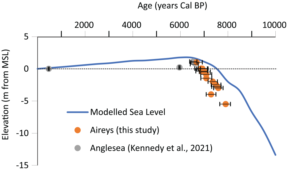
Infill of the estuary closely tracked sea level in Painkalac Creek. The sea level curve is derived from GiA modelling by Goodwin et al. (2023), with the radiocarbon ages corrected to elevation with respect to mean sea level. The rate of infill closely tracked the rate of sea level rise for the region.
As the estuary closely tracked sea level during the mid-Holocene it can therefore be used to provide further indication on the spatial extent of the maximum sea level elevation recorded elsewhere in eastern Australia (Lewis et al., 2013) and on the other side of the Tasman Sea (Clement et al., 2016; Kennedy, 2008; Kennedy et al., 2022) during this period. Evidence for a mid-Holocene sea level highstand along the open coast of Victoria, southern Australia, has generally been scant. Fixed biological indicators at Cape Liptrap (165 km east-south-east) suggest a higher sea level of 1.5 m at around 5.5–5.0 ka (Gardner et al., 2009; Haworth et al., 2002), while at Anglesea elevated estuarine shells at +1.14 m date at 6704–6381 cal BP (Kennedy et al., 2021; Figure 9). As the average elevation of the infilled part of the estuary is +2.34 ± 0.51 m and composed of estuarine sediments this further suggests deposition during a period of higher sea level. Combined with the shallowest age (1 m from the surface, +1.021 m above MSL) within Aireys/Painkalac of 6930–6440 year cal BP being very similar to that of Anglesea provides further evidence that a period of higher sea level during the mid-Holocene occurs along the south east coast of Australia.
Sediment sources
The absence of contemporary accommodation space and the rapid rate of infill leads to questions regarding the sediment source. The molluscs found throughout the studied interval, particularly concentrated in the coarse sandy units, are of all marine and estuarine origin with a habitat range into the intertidal zone. The bivalves Eumarcia fumigata exclusively occupies inter to subtidal areas, while Katelysia and Macomona deltoidalis can live up to 30 m in water depth. The gastropods Nassarius are common on the intertidal mud flats of modern estuaries in the region and have been found living in water depths of up to 70 m (Beechey, 2023; Boyd, 2011; Grove, 2018). The texture and colour of the sediments in which the molluscs are found are also visually typical of mud basin sediments in marine dominated settings both in the region (Kennedy et al., 2020a, 2021) and in eastern Australia (Sloss et al., 2005, 2010). The implication is that the bulk of the infill in Aireys Inlet is of marine origin, though it is acknowledged that detailed microfossil work, such as using foraminifera would be needed to conclusively prove this theory.
A low degree of terrestrial input into the system can also be inferred by the morphology of the barrier that forms the seaward edge of the estuary. This, undated landform, is composed of a single narrow dune and lacks progradational morphology such as foredune ridges. If the terrestrial material was the dominant sediment source, then it is certain that once infilled this material would continue to have been delivered from the catchment and then deposited on the open coast. In the few infilled barrier estuaries in Australia, once the estuary infilled, the continued terrestrial sediment supply led to the progradation of the beach-dune barrier sequence and the creation of a series of foredune ridges sequences such as in Bega (Oliver et al., 2023) and the Shoalhaven River (Carvalho and Woodroffe, 2020; Carvalho et al., 2019; Umitsu et al., 2001). The dominance of marine over terrestrial sediment infill also occurred in the lower portion of the adjacent Anglesea Estuary (Kennedy et al., 2021). The landward edge of the infilled mud basin within Painkalac Creek is inferred to be dominated by incised fluvial sediments based on is spatial relationship to the infilled estuary. The sedimentological relationship between this area and the basin is unknown, however the surface morphology, specifically the LiDAR measured surface elevation and slope, would indicate that the estuarine sequence extends to the centre part of the basin and the fluvial system is likely small, and potentially its infill of the upper parts of the river valley occurs over many sea level cycles.
Model of estuarine infill
The classic pattern of infill for a barrier estuary is characterised by seaward progradation of a fluvial delta and landward movement of tidal delta into a low energy central mud basin (Roy, 1984; Roy et al., 2001). This is observed in many locations along the east coast of Australia such as Tuggerah Lake (Macreadie et al., 2015), Dee Why Lagoon (Chagué et al., 2019), Lake Illawarra (Sloss et al., 2005), Lake Conjola (Sloss et al., 2010) and the Minnamurra River estuary (Haslett et al., 2010; Panayotou et al., 2007) as well as in at the northern end of the South Island, New Zealand (Kennedy et al., 2022). Importantly, for the central mud basin to form, the catchment shape must allow for enough accommodation space to be available with respect to the vertical position of sea level (Cooper, 1993) and this does not always occur such in Anglesea Inlet which is adjacent to the study site (Kennedy et al., 2021).
For Painkalac Creek, there was ample accommodation space available for the formation of a central mud basin, with the pre-Holocene surface being in excess of 9 m depth below the current land surface. The fluvial delta is absent from the studied sedimentological record, but is certainly present at the rear of the flood plain. The character of the sediments within the basin is not however consistent with a classic mud basin infill with two distinct sediment units found within the muds at an elevation of c. −1.0 and −4.5 m from MSL buried within finer mud-dominated material. Based on the age-depth model for the estuary (Figure 9), the shallower layer is around 7100 cal BP while the deeper layer is around 7700 cal BP. At this time, based on the eastern Australia sea level curve (Lewis et al., 2013; Sloss et al., 2007) the layers would have been at a water depth of around 1.5 and 4.5 m respectively. The sands are certainly of marine origin given their molluscan assemblages and are reworked given the shell taphonomy. In the near-completely infilled macrotidal barrier estuary of Louisa Creek in central Queensland, northern Australia, sand wedges of marine origin contained with larger mud sequences were interpreted to represent a change in hydrodynamics of the system from flood to ebb dominated during infill and associated mangrove growth (Lessa and Masselink, 1995). Similarly in the infilled Bega River estuary, Oliver et al. (2023), suggested that during its early stage infill, prior to a beach-barrier forming, energetic tidal currents dominated the newly flooded bedrock valley. On the basis of the stratigraphic interpretation in these two estuaries we suggest that the lower sandy unit within Aireys Inlet is also representative of tidal shoals. While it is possible that high-energy waves may have impacted the coast leading to the deposition of coarse material within the system, the absence of similar deposits regionally at any period during the Holocene suggest this is unlikely.
The infill history of Aireys Inlet appears to differ from the standard models of Roy (1984; Figure 10). At the time of flooding the estuary was completely open, and likely to be tide dominated. This led to the development of subtidal shoals in the centre of the bay as marine sand was reworked landward. The planform shape of the incised bedrock valley inwhich the system forms suggests it may have been hypersychronous, with tidal amplification occurring when it was an open water body (Dalrymple and Choi, 2007). The tidal influence would have been modulated, geologically-controlled, by the presence of a shallow bedrock sill at the estuary entrance (Figure 10). This sill can be observed at the low tide mark on the beachface today (Figure 2c). It is possible that the sill, through providing a physical subtidal barrier across part of the estuary entrance dampened the tidal amplitude to an extent that the initial tidal dominance of the system was not able to inhibit beach-barrier formation once sea level stabilised. The development of this beach-barrier at the mouth of the drowned river valley led to the estuarine basin to become low energy throughout its length with coarse sediment restricted to a flood tide delta landward of the estuary mouth. Once the mouth began to intermittently close, as seen today (McSweeney et al., 2017a), deposition with the flood tide delta ceased and fine muds dominated the estuary. The estuary can therefore be considered to have infilled firstly in a tide-dominated mode (e.g. Dalrymple and Choi, 2007). The second phase was more akin to a classic barrier estuary infill once the beach-barrier sequence was established. This infill and change in process dominance all occurred within less than 1200 years, a very short period when compared to other estuaries in southern and eastern Australia. The final stage of infill was charactersied by a thin (<0.5 m thick) fine mudy sequence with interbedded sand and mudy couplets suggests a low energy environment with occasional flood deposition, likely from Painkalac Creek which now passes through the area as a defined channel.
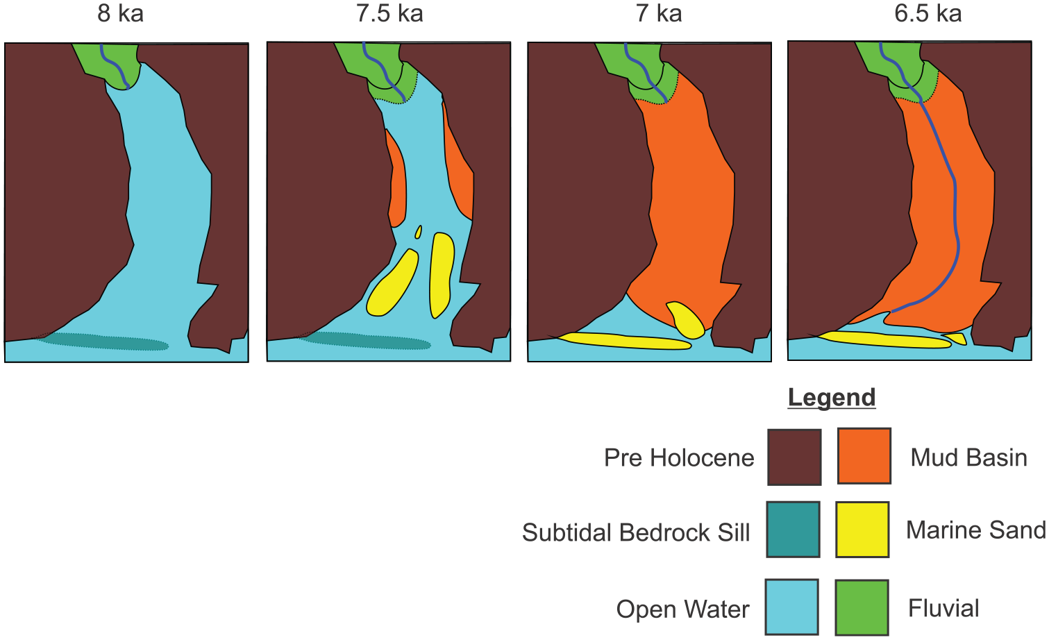
A schematic model of infill for Painkalac Creek. The estuary infilled rapidly and underwent a transition from being tide- to wave-dominated once the beach-barrier sequence was deposited on top of a subtidal bedrock sill.
The rapid infill of the estuary also provides a unique window into the climate, as viewed through the proxy of vegetation, in the region soon after sea level attained its present position. As the sediments are transported into the estuary the palynomorphs preserved within the sediments represent an overall regional vegetation character (Armour and Kennedy, 2005). The catchment, like much of southern Australia during this time, was dominated by Eucalyptus (Dodson, 2001). In the Western Volcanic Field region that lies inland of Aireys Inlet, the eucalypt woodland was open with common Casuarina and Asteraceae species (Edney et al., 1990; Harle et al., 1999). The pollen record within Painkalac Creek suggests a wetter environment than these inland sites as evidence by the abundance of Cyperasceae (sedges). The high abundance of the aquatic Haloragaceae species in the last stage of infill further supports the final infill stage being dominated by aquatic flats.
Conclusion
Aireys River Estuary, the lower part of the larger Painkalac Creek river valley, is an infilled barrier estuary. The estuary infilled rapidly during a 1200 year period in the early Holocene immediately after sea level flooded the former fluvial basin. The rate of infill was almost 5 mm/year resulting in a sequence of Holocene sediment over 9 m thick dating between 8130 and 6850 cal BP. The pattern of infill of the estuary differs from traditional models of barrier estuary evolution on wave-dominated coasts. It appears that the sediment distribution within the basin was tidally dominated during its early phase and then became wave dominated once a barrier formed at its mouth. A subtidal bedrock sill which appears to underly the modern barrier likely reduced deep-water wind wave energy within the estuary during the period when it was open to the ocean. The sediment source for infill is inferred to be of marine in origin based on the macro-mollusc assemblages. Terrestrial input was low, with such material restricted to the upper parts of the catchment which were subaerial during the entire Holocene. A limited terrestrial source is also inferred from the lack of evidence of barrier progradation on the open coast. This pattern of rapid marine sediment infill, occupying all the available accommodation space during the early to mid-Holocene sea level maximum appears to be common in the intermittently open-closed estuaries of Victoria, Australia.
Footnotes
Acknowledgements
We thank the Surf Coast Shire and local landholders for permission to sample the estuarine floodplain. The assistance of the undergraduate students of the subject Geog30001 is appreciated in the collection of the push cores. Ian Goodwin is thanked for provision of the sea level modelling data. Review comments Colin Woodroffe, Bruno Campo and one anonymous reviewer were appreciated and improved the manuscript.
Funding
The author(s) disclosed receipt of the following financial support for the research, authorship, and/or publication of this article: This research was funded through the student research capstone experience of the Office for Environmental Programs at The University of Melbourne.