
Abstract
The sedimentary sequences found within estuaries in the north west Nelson region of central New Zealand are investigated in order to quantify the timing of the end of the Post Glacial Marine Transgression. This region has been identified as being relatively stable in terms of vertical tectonic movement during the Holocene, but is yet to yield any reconstructions of eustatic sea level. In this study, we investigate the Holocene infill of a barrier estuary (Parapara Inlet) through sedimentological analysis and radiocarbon dating of 18 vibracores up to 4.2 m in length. It is found that the estuary infilled through a combination of lateral flood tide and fluvial delta progradation as well as vertical central basin infill. The central basin infilled at a consistent rate of 0.4 mm/year in both the mid (7.0–6.0 ka) and late-Holocene (2.5–1.5 ka). By the time of early human (Maori) settlement (c. 1 ka), the estuary surface was at low intertidal elevations with sediment being transported from the fluvial to tidal delta. A discernible change in sedimentation rates could not be associated with Maori settlement; however, infill rates increased to at least 12.5 mm/year in the past 150 years due hydraulic sluicing associated with mining. The sedimentary history of Parapara Inlet is compared to nearby Whanganui Inlet, d’Urville Island and Nelson to establish the character of regional Holocene sea level movement. It is found that relative sea level reached modern elevations between 8 and 7 ka in the region. The similarity between sea level curves for the end of the post glacial marine transgression (PMT) to other tectonically stable sites in northern New Zealand suggests that this curve can now be considered a true eustatic signal for the New Zealand archipelago.
Introduction
Estuaries are sinks for sediment derived from terrestrial and marine sources (Dalrymple et al., 1992; Kennedy, 2011). In wave-dominated settings they are classified on whether a beach-barrier sequence can form at the mouth of a drowned catchment and as a result barrier estuaries are often found on depositional coasts (Davis and Hayes, 1984; Roy, 1984; Roy et al., 2001) where sediment supply is high (Fruergaard et al., 2018; Otvos, 2018). On coasts where the shelf slope is steep and net sediment flux is oceanward during transgressions, drowned river valleys with bedrock-defined open entrances are more commonly found (Roy et al., 1994).
The evolution of wave-dominated estuaries is commonly defined as a function of the spatial extent of the marine and fluvial deltas with the relative dominance of marine (wave and tide) and fluvial processes determining the precise pattern of infill (Cooper, 2001; Dalrymple, 2006; Dalrymple et al., 1992; Roy, 1984). The available accommodation space within an estuary is a major boundary condition to the pattern of infill, being determined by the bedrock morphology and the rate of sea level rise (Cooper, 1993a). In general, accommodation space is greatest soon after the stabilisation of a rising sea level and gradually reduces through time as sediment accumulates (Dalrymple et al., 1992; Roy et al., 2001; Sloss et al., 2005). For this reason, estuarine sediments are commonly used for the reconstruction of past sea levels especially along on temperate shorelines (Murray-Wallace and Woodroffe, 2014).
The age-depth relationships of molluscs preserved in the subsurface of estuaries form the primary evidence for relative sea level change during the Holocene in south eastern Australia (Lewis et al., 2013) and New Zealand (Clement et al., 2016). In New Zealand, active tectonism significantly complicates the interpretation of relative Holocene sea level (Gibb, 1986). The Golden Bay – north west Nelson region has been shown to be relatively stable during this period (Williams, 1991) and is identified as an important location for understanding regional sea level variation (Kennedy, 2008), but is yet to yield any reconstructions (Clement et al., 2016). Estuarine sedimentary records from this region therefore have the potential to fill critical gaps in understanding of Holocene sea level variation in the Tasman Sea and southern Pacific Ocean.
In this study we investigate the Holocene infill of an unstudied barrier estuary, Parapara Inlet (north west Nelson). We then combine the Holocene chronology of Parapara Inlet, with new dating from an infilled drowned river valley estuary (Whanganui Inlet) in the same region whose evolutionary history appears closely linked with sea level (Kennedy et al., 2008).
Regional setting
Regional geology
North west Nelson is located at the top of the South Island of New Zealand (Figure 1). The region is considered to be tectonically stable during the past 690 ka with uplift rates of 0.07–0.09 m/ka estimated to have occurred based on spelaeothem dating (Williams, 1991). This interpretation of vertical stability is further supported by a lack of raised marine terraces (Rattenbury et al., 1998). Sea level in the New Zealand region is generally recognised to have reached present elevations by 6.5 ka and is likely to have been up to 1.5 m above present during the mid-Holocene (Gibb, 1986; Kennedy, 2008).
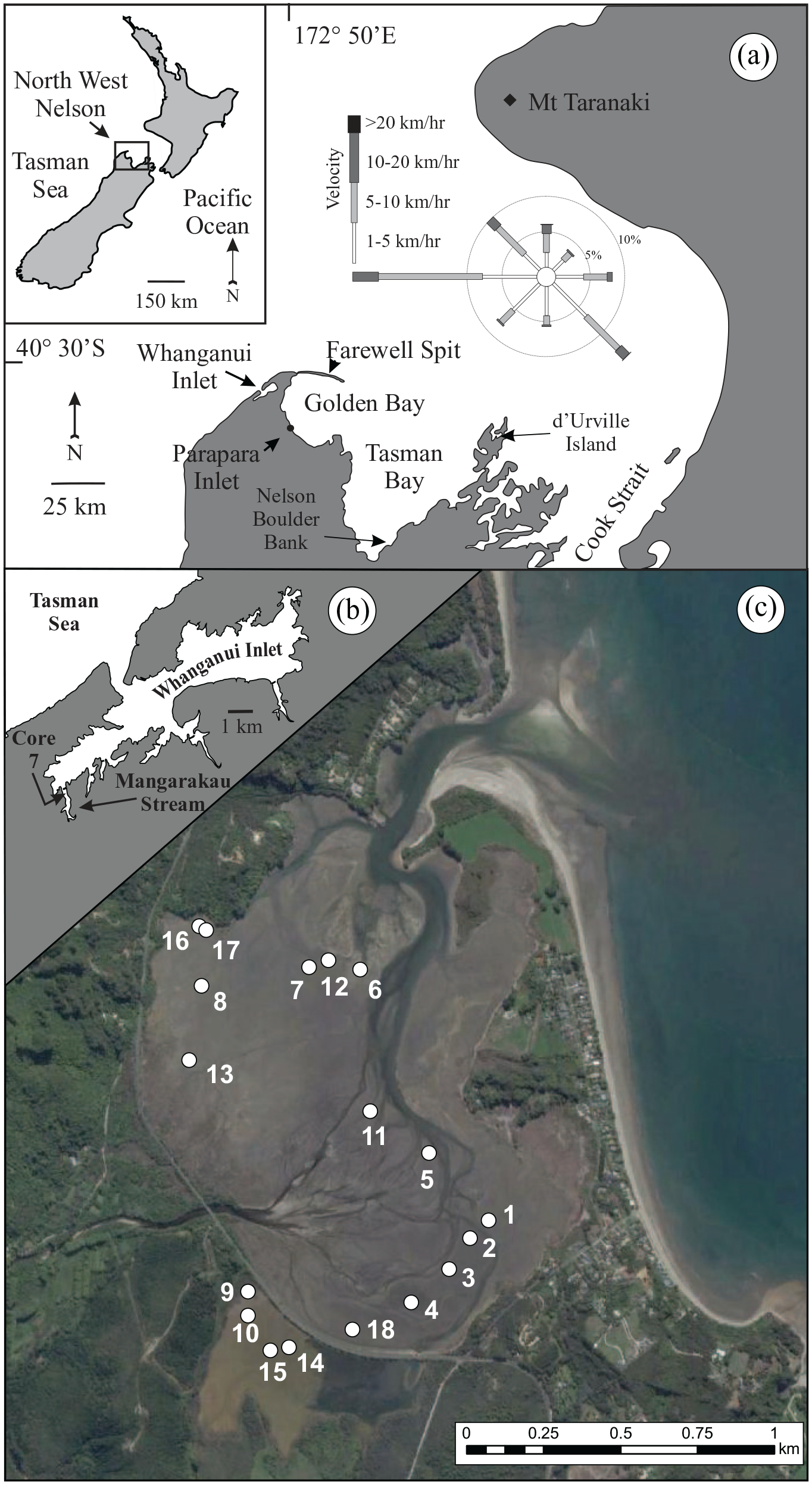
(a) Location of Parapara and Whanganui Inlets at the northern end of the South Island of New Zealand. Parapara Inlet lies at the southern margins of the semi-enclosed Golden Bay. (b) The location of the redated core 7 from Kennedy et al. (2008) in Whanganui Inlet. (c) The location of vibracores collected around the margins of the fluvial delta in Parapara Inlet. The delta could not be sampled due to the presence of coarse fluvial gravels. Wind data for 1972–2009 for the eastern tip of Farewell Spit from Tribe and Kennedy (2010).
Parapara Inlet
Parapara Inlet (40º43.5′S, 172º41′E) is a barrier-type estuary, c. 2 km long and 1 km wide, located within Golden Bay (Figure 1). The inlet’s catchment is approximately 45 km2 rising to its highest point at 1000 m. It has a mean annual precipitation up to 3000 mm (Macara, 2016). The catchment is composed of lithologies ranging back to Cambrian age. The oldest rocks are found in the Waingaro Schist Zone which includes greenschist and schistose units derived from volcanic sequences (Rattenbury et al., 1998). Siliceous silt and sandstones with interbedded limestone and marbles of the Mt Arthur Group (Ordovician – Silurian) as well as Permian quartzites, slates and conglomerates of the Parapara Group are also present. Miocene calcareous mudstones of the Blue Bottom Group outcrop on the northern and western margins of the inlet as well as Oligocene limestones of the Nile Group (Rattenbury et al., 1998). The seaward barrier separating the inlet from Golden Bay is at least Holocene age (McFadgen and Challis, 1979) and is composed of undated Quaternary and Paleogene-Neogene sediments (Rattenbury et al., 1998). Mineralised deposits, namely gold and iron-bearing, were extensively exploited from the catchment for half a century from the 1870s (Dawber and Win, 2008; Hector, 1892; Newport, 1971).
Whanganui Inlet
Whanganui Inlet (40º43.5′S, 172º41′E) is a drowned river valley, 13 km long and up to 3 km wide, infilling an ancient graben (Figure 1). It is located at the north west tip of the South Island, with its entrance opening into the Tasman Sea. The inlet’s catchment is approximate 216 km2, rising to a maximum elevation of 506 m with a mean annual rainfall of between 1200 and 2000 mm (de Lisle and Kerr, 1965). Late Cretaceous shallow marine sandstones dominate the catchment, overlying Early Cretaceous granites that outcrop at the highest elevations, while Oligocene limestones characterise the inlet’s western boundary (Rattenbury et al., 1998; Wizevich et al., 1992). The inlet is almost entirely infilled with extensive sediment flats exposed at low tide (Armour and Kennedy, 2005; Kennedy et al., 2008) which merge with erosional shore platforms along the estuary sides (Kennedy and Paulik, 2007). The intertidal sediment flats infilled close to present elevations by the mid-Holocene with ages of 4–5 ka occurring within 1 m, and 7.8 ka within 1.8 m of the sediment surface (Kennedy et al., 2008).
Hydrology
Tides within Golden Bay are mesotidal with an average spring range of 4.7 m at Collingwood, 4.5 km north of Parapara. Wave heights within the bay are fetch-limited and are estimated to range up to 2.25 m at the mouth of the inlet (CMP, 2019). Whanganui Inlet has a semidiurnal tide with a spring range of 3 m. Average significant wave height in the Tasman Sea, outside of the inlet, is 2.4 m (T = 7.5 s) (Pickrill and Mitchell, 1979). Wave characteristics within the inlet while unmeasured are observed to be very low due to the infilled character of the estuary which is subaerially exposed at each low tide.
Methods
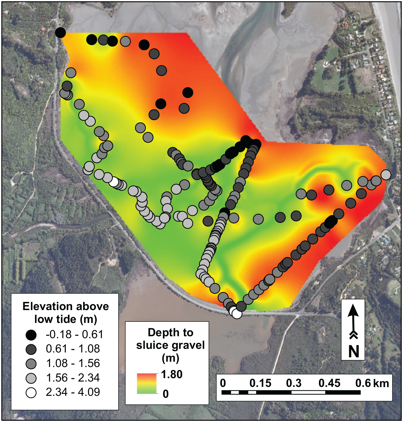
Eighteen vibracores were collected from Parapara Inlet using a modified 2 hp concrete vibrator to sink 75 mm diameter aluminium pipes into the intertidal flats (Figure 1). This is the same methodology used to collect core 7 in Whanganui Inlet by Kennedy et al. (2008) which is redated here (Figure 1). In Parapara Inlet, a maximum depth of 4.19 m was achieved by coring, with an average compaction of 0.28 m. Coring locations were selected to provide a representative sample of the estuarine surface environment based on field observations in comparison with aerial photography. The centre of the fluvial and flood tide deltas could not be sampled due to the presence of coarse gravels. A stainless-steel rod 1.5 m in length was used to determine sediment depth in areas which could not be cored. At the time of coring (2009 and 2010), all sites were surveyed using a SOKKIA SET 4000 electronic distance metre and reduced to local tidal levels due to a lack of precise vertical survey marks. Aerial LiDAR was flown over both estuaries from 2016 to 2017 by the Tasman District Council. The data was sourced from the LINZ Data Service (LINZ, 2021) and licensed by the Tasman District Council, for re-use under the Creative Commons Attribution 4.0 International licence. The location of each core was mapped onto the LiDAR from which core elevations with respect to mean sea level are calculated. Vertical aerial photos, all taken at low tide, are georectified and analysed in ArcMap (v. 10.5). The surface sedimentary zones are classified on the basis of visual interpretation supported by ground truthing in the field.
Sediment from the vibracores was sampled every 100 mm, and analysed for texture, calcium carbonate and total organic carbon (TOC) content. Sediment size analysis was conducted using a Beckham Coulter LP13320 particle sizer for grain sizes <0.5 ɸ. Dry sieving was conducted on the coarser size fractions. All material subsampled from the cores was wet sieved at 1.5 mm prior to insertion into the sizer. Where grains were retained in the sieve, a larger (c. 50 g) sample was extracted from the cores at the same depth interval. Samples were dried at 100°C for 24 h, weighed, then wet sieved at 1.5 mm. The material retained within the sieve was dried for a further 24 h, and dry sieved at 0.5 ɸ mesh intervals. Calcium carbonate and TOC analysis was conducted through acid digestion in accordance with Kennedy and Woods (2013). X-ray Fluorescence (XRF) analyses were conducted at SpectraChem Analytical (Lower Hutt, New Zealand) using Borate fusion X-ray spectrometry.
Radiocarbon dating was conducted at the University of Waikato Radiocarbon Laboratory using Atomic Mass Spectroscopy. All ages have been calibrated using CALIB 8.1.0 (Stuiver and Braziunas, 1993; Stuiver et al., 2020) and are reported at the 95% confidence interval as years cal BP (Table 1). A Delta R value of 0 based on the ‘Marine20’ curve (Heaton et al., 2020) is used for mollusc samples. The Delta R values within the Marine20 curve are based on a range of sites from eastern Australia (Gill, 1983; Gillespie and Polach, 1979; Komugabe-Dixson et al., 2016) and New Zealand (Petchey and Schmid, 2020) however as noted by Ulm (2006) along the southern Australian edge of the Tasman Sea, and by Petchey and Schmid (2020) in New Zealand, mean Delta R values are highly variable today. Combined with the uncertainty of Delta R in the mid-Holocene in an estuarine environment, we opted for use of the Marine20 curve rather than applying regional New Zealand values. The difference between the Delta R corrections on the calibrated ages is a maximum of 300 years.
Radiocarbon ages for shell and organic material retrieved from Parapara and Whanganui Inlets as well as the Nelson Boulder Bank calibrated using the Marine 20 curve of Calib 8.10 using a delta R value of 0 with error reported to two standard deviations.
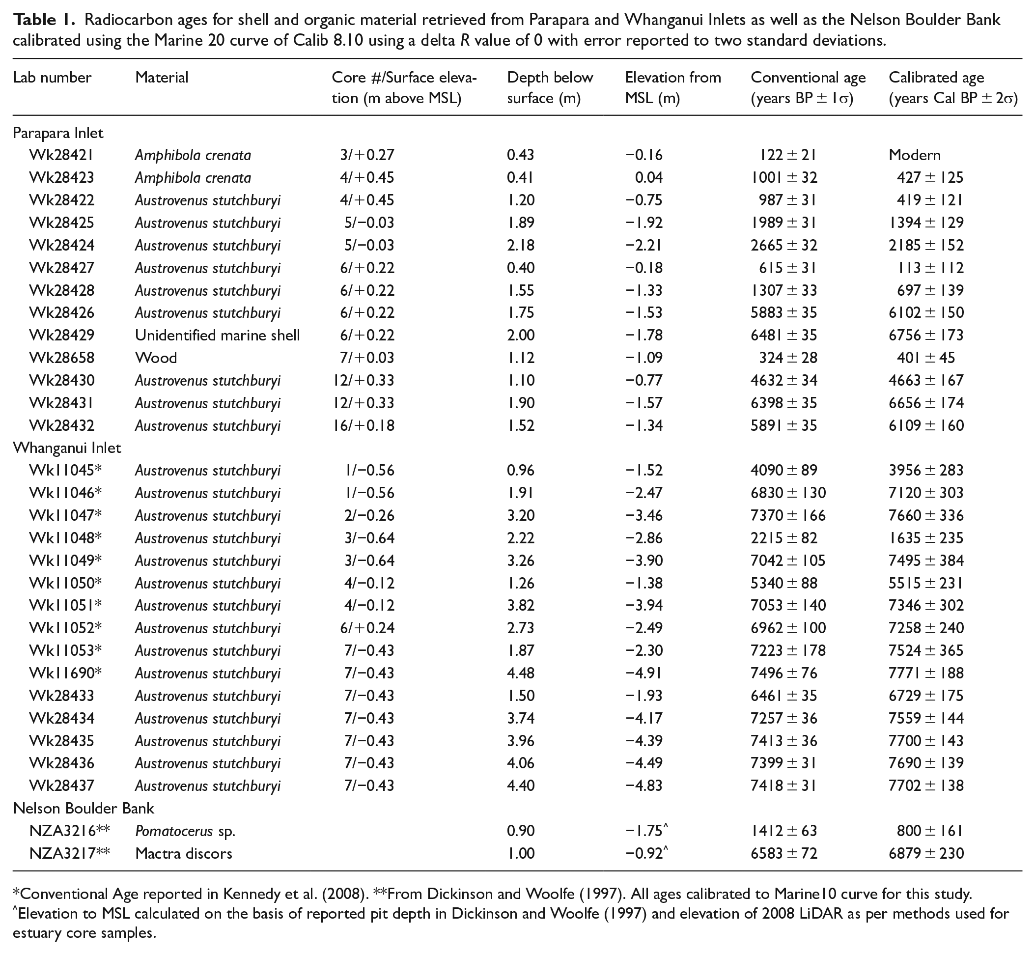
Conventional Age reported in Kennedy et al. (2008). **From Dickinson and Woolfe (1997). All ages calibrated to Marine10 curve for this study. ^Elevation to MSL calculated on the basis of reported pit depth in Dickinson and Woolfe (1997) and elevation of 2008 LiDAR as per methods used for estuary core samples.
For each shell dated, the vertical error on its elevation is based on the life history of the species. Austrovenus stutchburyi is the primary species used in New Zealand for the reconstructions of past sea level elevation. The review of Clement et al. (2016) confined the life cycle of A. stutchburyi to between MSL and MLWS elevations. Fisheries reports of this commercial species (MPI, 2021) place its life history as extending from the ‘lowest high water neap tide to the lowest part of the shore’ (p. 141) a range consistent to that observed in the field throughout the North Island of New Zealand (Orsman, 2011). Reworked shell material is also observed in the tidal channel thalwegs of both inlets that are exposed at low tide. Samples were not collected from the base of the main subtidal channels. As life and death assemblages of each dated species is observed to occur between spring high and low tide mark in each estuary, we assume a vertical accuracy in relation to sea level to be equivalent to the tidal range. This is 4.7 m in Parapara Inlet and 3.0 m in Whanganui Inlet.
Results
Contemporary surface zonation of Parapara Inlet
The sediment flats within the contemporary Parapara estuary (2009 aerial image) are subaerially exposed at low tide. A single fluvial-tidal channel (up to 95 m wide, 1.7 km long and 24.55 ha in area at low tide) flows from the fluvial delta to the estuary mouth which is permanently open (Figure 2). The estuary has a total area of 200.2 ha and circumference of 11.82 km.
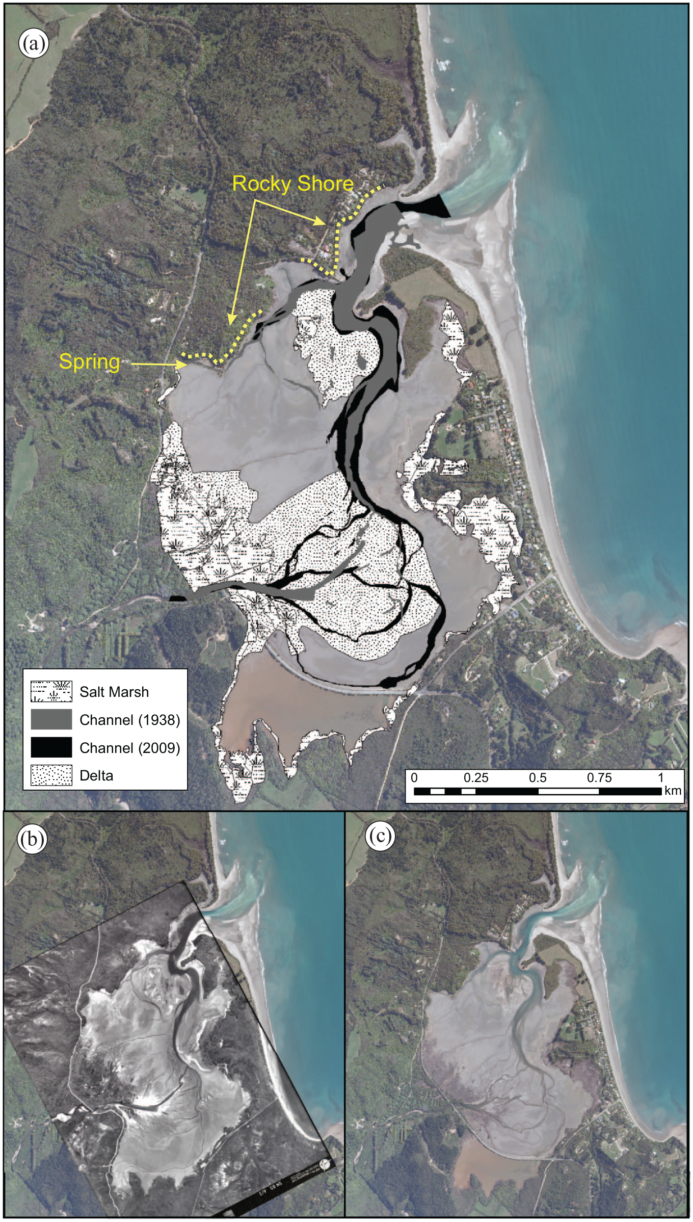
(a) Surface sedimentary zones of Parapara Inlet based on aerial photography analysis and ground truthing. Sediments from the fluvial delta are able to be transported to the estuary mouth through the fluvio-tidal channel. Aerial photographs of Parapara Inlet in (b) 1938 and (c) 2009. The fluvial channels in 1938 are more active as indicated by the presence of overbank splay deposits particularly at the head of the fluvial delta.
The intertidal flats contain mud to medium-sand size sediment. The finest grain sizes occur in the southern end of the estuary where a causeway built in the 1950s has dammed 22.9 ha of intertidal flats that are now rarely subaerially exposed (Figure 3a). The flats closest to the deltas tend to be coarser with sandy muds dominating most of the estuary (Figure 3b). Austrovenus stutchburyi was found living throughout the estuary with Amphibola crenata being common in areas dominated by finer muds (Figure 3c), excluding the dammed section which appeared to be devoid of macro-molluscan fauna.
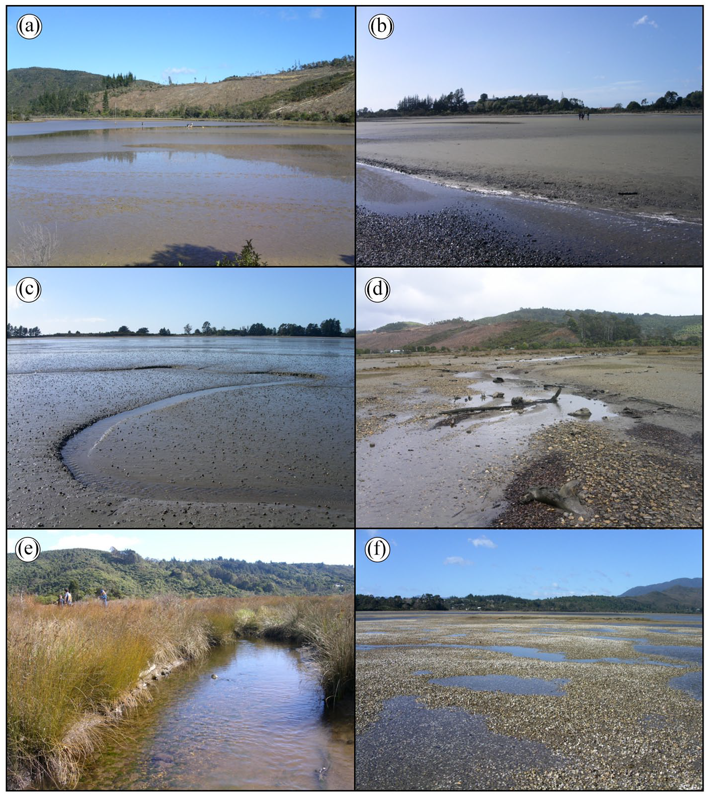
The contemporary surface character of Parapara Inlet. (a) The intertidal estuary surface, dominated by mud, behind the road causeway at the southern part of Parapara Inlet. (b) The intertidal sandy muds adjacent to the fluvial delta. (c) A meandering tidal channel with abundant Amphibola crenata living on the fine-grained sediment. (d) A contemporary channel on the fluvial delta containing quartz and shell gravels. (e) Supratidal marsh vegetation with a gravel floored fluvial channel near the mouth of the Parapara River. (f) Surface of the flood tide delta dominated by gravels composed of reworked Austrovenus stutchburyi valves.
The fluvial delta of the Parapara River extends almost entirely across the centre of the estuary (Figure 2) accounting for 28.67% of the total surface (area 57.04 ha). It rises to supratidal elevations at just under 2.5 m above the low tide mark (Figure 4) and is dominated by coarse gravel composed of a mix of quartz and local bedrock lithologies (Figure 3d). The highest parts of the delta are colonised by salt marsh species of such as Isolepis nodosa and Juncus maritimus (Figure 3e).
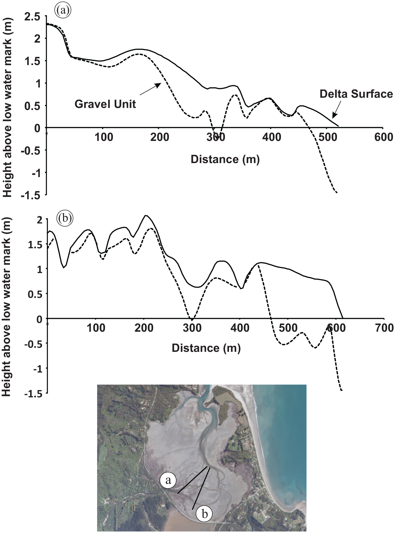
Topographic cross sections across the fluvial delta of Parapara Inlet. A unit formed of gravel material liberated from the catchment by hydraulic sluicing is found buried beneath the contemporary tidal flats.
Just landward of the estuary mouth is a flood tide delta composed of quartz and shell gravel, dominated by whole disarticulated valves of A. stutchburyi (Figure 3f). The delta accounts for 4.71% (9.43 ha) of the surface area of the estuary and rises to supratidal elevations in its centre where small (10s m wide, and decimetre relief) patches of grass are found in which fine grained sand has accumulated (Figure 2). The fringe of the estuary is dominated by salt marsh, accounting for 17.58% of the surface area. Rocky cliffs are found at the north western edge where a freshwater spring occurs (Figure 2).
1938 estuary surface zonation of Parapara Inlet
The surface zones identified in 2009 appear to have been present in the earliest (1938) aerial imagery (Figure 2). The tidal flats are all exposed at low tide in 1938 which suggests a broadly similar elevation to today. The delta area is the same as are the salt marsh extents on the shoreline. The fluvial delta appears to be more active in 1938 with a single channel in its centre around which there are bare splay deposits which are particularly marked at the delta head (Figure 2b). A small channel around 18 m wide which occurs at the landward margin of the delta on its southern side, is also dominated by bare sediment splays. Similar splay deposits, up to 135 m wide, are present in the image 500 m further north of the main channel where a small secondary delta is active (Figure 2). The total channel area in 1938 is 40.29% less than in 2009 (15.79 ha compared to 24.55 ha) (Figure 2c). The only other major difference between 1938 and 2009 imagery is the absence of the causeway in the southern part of the estuary. In this area there are well-defined sediment flats with a small meandering tidal channel being present.
Subsurface sedimentology and chronology of Parapara Inlet
The Miocene Blue Bottom Group is encountered at 1.52 m depth at the northwestern corner of the estuary (Figure 5). It is composed of a blue grey polymodal muddy sand which is denser than the overlying estuarine units. Carbonate content within the unit averages 9% (range 7–10%) and TOC is between 4% and 5%. Shell macrofossils are absent with fine rootlets apparent. A whole Austrovenus stutchburyi valve directly overlying this unit dates at 6109 ± 160 years cal BP (Table 1).
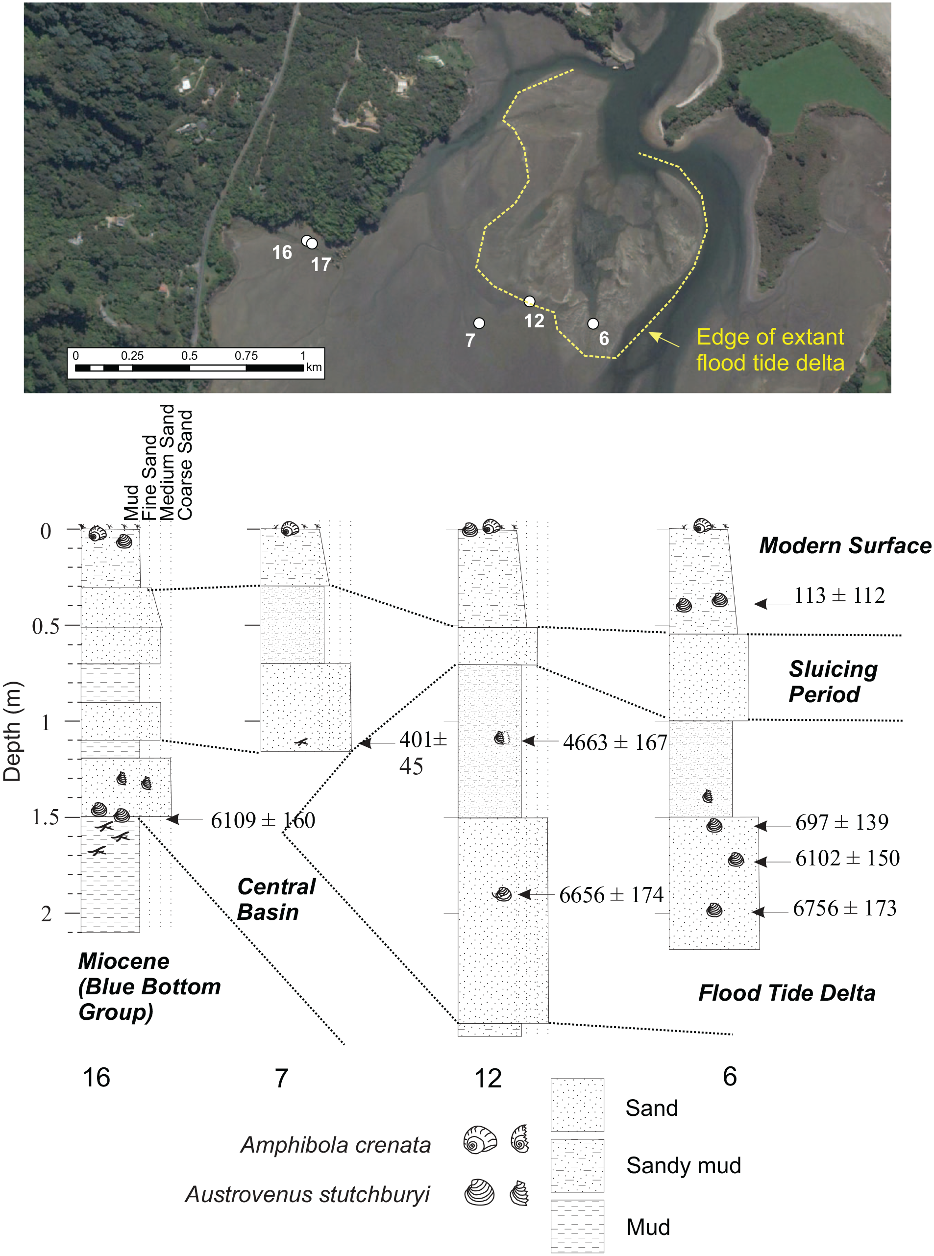
A transect in the northern part of Parapara Inlet across the front of the flood tide delta. The pre-Holocene sediments are encountered at 1.5 m depth, with sluicing spoil forming a layer up to 1.7 m thick.
The deepest sampled sediments occur at 4.10 m depth in core 18 and are composed of a brown sandy mud and grey sandy silt. The unit is at its maximum thickness (2.8 m, core 18) in the southern part of the estuary straddling the 1950s causeway (Figure 6). Small woody fragments are found throughout the unit, but mollusc shells are absent. The carbonate content is low within the brown unit at 4.93% ± 0.04%, while it is slightly higher at 6.05% ± 0.04% in the grey sandy silt. The TOC of the muds is much higher than the sandy silts at 13.69 ± 0.12 compared to 4.58% ± 0.05% respectively. This unit extends up to 0.5 m depth from the modern surface at the southern edge of the estuary (cores 14 and 15) but is most commonly found at depths below 1.5 m in the centre of the estuary basin where it is buried by coarser sediments (Figure 6).
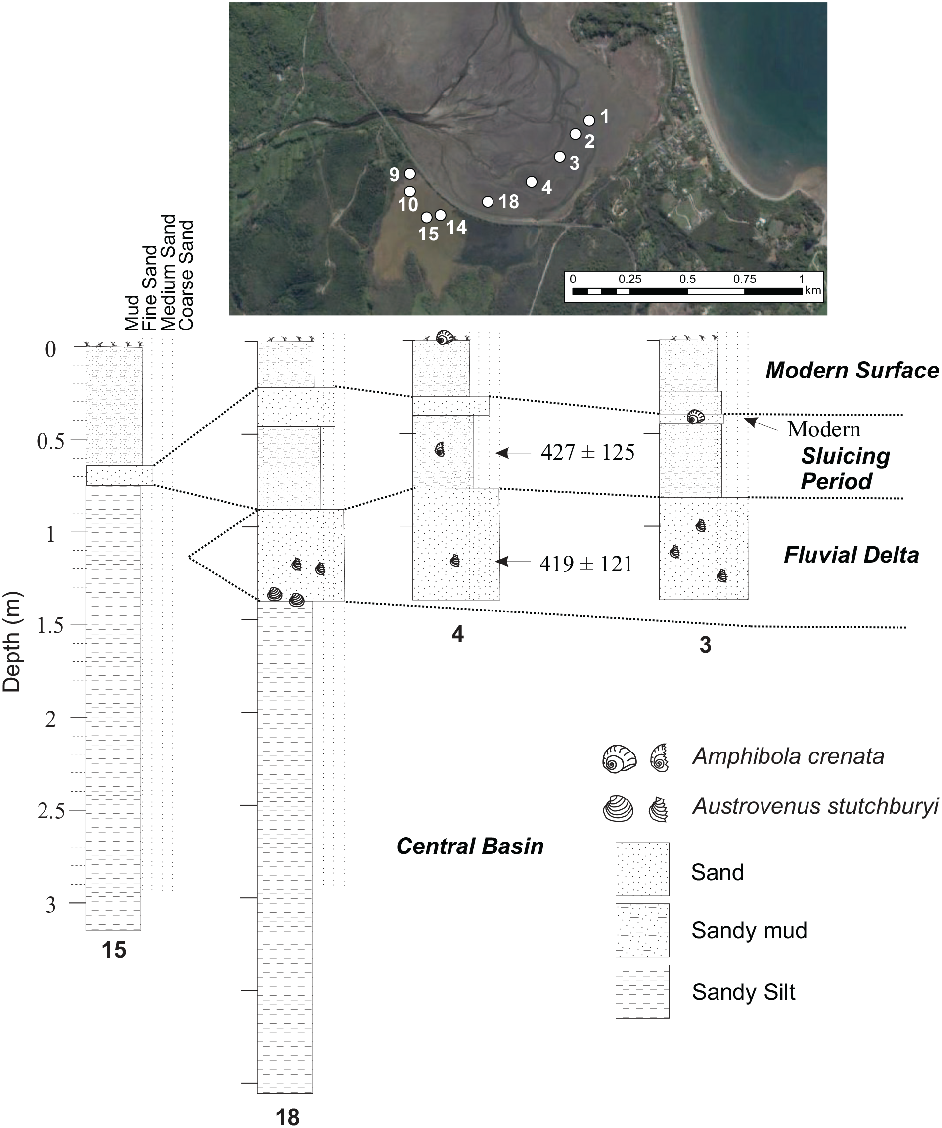
A transect in the southern part of Parapara Inlet parallel to the side of the fluvial delta. The central basin sediments are thickest in this part of the system.
Unconformably overlying the muds and silts is a moderately sorted unimodal coarse dark sand. It contains layers of shell which vary up to 100 mm in thickness and are composed predominately of A. stutchburyi, with an absence of floral macrofossils. The unit has a high carbonate (10.50% ± 0.03%) and low TOC (2.08% ± 0.02%) content. This unit is present throughout the estuary ranging from a maximum depth of 3.0 m below the surface in core 5–0.6 m in core 2 (Figures 5 and 6). The oldest dated shells within Parapara Inlet occur within this unit with a whole A. stutchburyi returning an age of 6756 ± 173 years cal BP at 2.00 m depth in core 6, just landward of the flood tide delta (Table 1, Figure 5). The shallowest part of the unit is much younger being 427 ± 125 years cal BP (A. stutchburyi at 0.41 m depth in core 4) and 401 ± 45 years cal BP (wood fragment at 1.12 m depth in core 7).
Overlying these deeper units is a coarse gravel composed of bedrock clasts mixed within a dark grey to grey fining upwards sandy mud. The gravelly parts of this unit are confined to locations at the edges of contemporary tidal channels (core 1 and 8) and occur at around 0.7 m depth. Where gravels are encountered in the field it is not possible to sample the underlying sediments. The gravels contain broken fragments of A. stutchburyi while in the finer units smaller shell fragments are found near the contemporary main channel (cores 1, 2 and 5). The carbonate content ranges from 2.05% to 15.00% with TOC of 0.25–14.63%. At 1.55 m depth just landward of the flood tide delta (core 6) a whole A. stutchburyi shell dates at 697 ± 139 years cal BP. In core 4, located at the edge of the fluvial delta shell fragments also returned a relatively young age of 419 ± 121 years cal BP (core 4) at 1.20 m depth (Figure 5, Table 1).
The upper parts of all the cores are composed of an orange unit which ranges in size from pebbles to a muddy sand. The sand component has a high quartz content. Reworked unidentified shell fragments within the gravel date at 113 ± 112 years cal BP at 0.40 m depth in core 6 (landward edge of the flood tide delta).
The estuary surface at almost each coring site, is a brown to grey very coarse silt to muddy sand that is most commonly is <0.4 m thick. On the fluvial delta, sediment probing indicated this unit is up to 1.5 m thick where it infills older gravel-dominated channels (Figures 4 and 7). Live A. stutchburyi are found in the grey units, while the more orange coloured sediment tended to be free of shell material. Vegetation is not present within this unit with the average TOC being between 2.16% and 2.48%.
Height of the contemporary fluvial delta and surrounding intertidal sediment flats in Parapara Inlet. The fluvial gravels of the delta extend beneath the extant intertidal flats to depths of at least 1.50 m.
X-ray fluorescence analysis was conducted on five samples in core 18 at the southern limit of the estuary (Figure 8). The most noteworthy variations occurred in the composition of iron oxide which is highest at the top of the core (7.4% at 0.1 m depth) decreasing to 1.6% close to the base of the core in the brown sandy mud and grey sandy silt unit. The other oxides had compositions of <2.6% with only minor variation down core, except for Al2O3 which varies 12.6% and 18.1%.
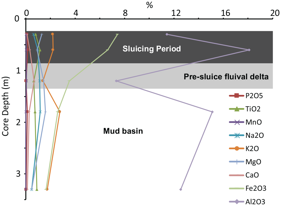
Down core variation in major oxides within core 18 at the southern edge of Parapara Inlet.
New chronology of Whanganui Inlet
Core 7 in Whanganui Inlet is located at the south western edge of the estuary at the mouth of Mangarakau Stream (Figure 1). It is composed of muddy fine sand with a silt and clay content of 30% (Kennedy et al., 2008). The core decreases in age from 7771 ± 138 year Cal BP at 4.48 m depth (4.91 m below MSL) to 6729 ± 175 years cal BP at 1.5 m depth (1.93 m below MSL) (Table 1). The seven ages are in chronological order apart from a small (10 year) age reversal in the mean age between 4.06 and 3.96 m core depth where the ages are around 7.7 ka. The overall rate of sedimentation for the dated section of the core was 3.32 mm/year, with the majority of accommodation spaced occupied during the early-mid-Holocene.
Discussion
Holocene infill of Parapara Inlet
Barrier estuaries are generally found within microtidal environments (Davis and Hayes, 1984; Woodroffe, 2003). The contemporary surface facies of Parapara Inlet reflect a typical microtidal barrier estuary with a landward fluvial delta, central basin and flood tide delta units (Roy, 1984). Both deltas appear to be relatively inactive today, especially compared to early in the 20th century. This interpretation is based on the occurrence of active splay deposits observed in the 1938 aerial photo (Figure 2), vegetation growth on their surface today (Figure 3e and f), and the burial of the delta’s margins by fine grained estuarine sediment (Figure 7). Fluvially-derived sediments, namely quartz pebbles sourced from the catchment, are also found within the flood tide delta and intertidal channels. This suggests that fluvial sediment is being reworked through the estuary and into the entrance. Once near the entrance these coarse sediments can be reworked landward by marine processes. These same processes maintain a permanently open entrance to Parapara Inlet as the relative tidal range exceeds the thresholds where a beach berm can form and cause estuary mouth closure (Lessa and Masselink, 1995; McSweeney et al., 2017a, 2017b).
In the early Holocene, soon after the Post Glacial Marine Transgression the estuary was an open water body with fine muds deposited in a central basin several metres deep. This is best represented in the southern part of the estuary (Figure 6) where the lack of mollusc shells and low carbonate content imply that the water depth was too great for species such as A. stutchburyi. The low energy environment appears to have also favoured the deposition of organic material from the catchment which would almost certainly have been forested at the time (Armour and Kennedy, 2005). The central basin in the northern part of the estuary was shallower, with accommodation space being limited by bedrock (sensu Cooper et al., 2012) (Figure 5). This environment was higher energy, as represented by sandy sediments and shallower with whole A. stutchburyi being found.
The abundance of gravel in the fluvial and flood-tide deltas prevented sampling of their subsurface and therefore their relationship with potentially underlying central basin facies is unknown. Traditionally, fluvial deltas prograde into an estuary progressively burying central basin units, and eventually deliver sediment directly to the open coast (Roy, 1984) such as observed in the Shoalhaven River in eastern Australia (Carvalho and Woodroffe, 2020; Umitsu et al., 2001). In Parapara Inlet, based on the sedimentology and radiocarbon evidence, the fluvial delta progressively extended into the estuary until around 4.8 ka. At c. 4.5 ka it appears that fluvial sediment was able to be transported to the estuary entrance and then reworked into the flood tide delta. Rates of vertical infill (based on the core depth of dated samples) of the edge of flood tide (Core 6, Figure 5) and fluvial delta (core 5) are calculated at 0.42 and 0.43 mm/year for the mid (7.0–6.0 ka) and late-Holocene (2.5–1.5 ka) respectively. These rates being similar in magnitude and timing to that inferred for a small barrier estuary on d’Urville Island 95 km to the east (Chagué et al., 2020).
By the time of human settlement in the region (c. 750–550 years Cal BP (McGlone and Wilmshurst, 1999)) Parapara had infilled to close to low tide elevations following the pattern of the standard Roy (1984) and Dalrymple et al. (1992) models of estuary sedimentation. This is similar the barrier estuaries found along the east Australian coast at Tuggerah Lake (Macreadie et al., 2015), Dee Why Lagoon (Chagué et al., 2019), and the Minnamurra River estuary (Haslett et al., 2010; Panayotou et al., 2007). In the late 19th and early 20th centuries the catchment was severely denuded by hydraulic sluice mining and river dredging (Dawber and Win, 2008; Hector, 1892; Newport, 1971). Globally, such mining activities quickly overwhelm catchments and sediment runoff and downstream sedimentation can be extreme (Lawrence and Davies, 2019). We interpret a fine orange coloured, iron-rich, mud and sand in the lower energy sections of the estuary as being spoil from the sluice mining based on the marked difference in sediment colour and texture as well as mineralogy (especially aluminium and iron oxides). The fluvial delta also appears unusually large for a catchment of its size in comparison with other aforementioned estuaries. This suggests that its surface is broadly inactive today and that its recent construction occurred under hydrological conditions very different to present. Sedimentation rates in the estuary are estimated to have been 12.5 mm/year during mining based on the maximum thickness of sluiced sediment found in the cores, assuming a mining date of 1870 AD with a return to natural sedimentation by 1950 AD (based on catchment condition in historical photos). While this rate is almost two orders of magnitude higher than the natural rate of sedimentation, it is also almost certainly a minimum value as it was not possible to core within the fluvial delta where the impact of sluicing would have been greatest.
The majority of accommodation space within Parapara Inlet was therefore occupied by the mid-Holocene. The earliest ages obtained from Parapara Inlet occur just after 7 ka, at −2 m where the shallower pre-Holocene surface provided a degree of geological control in the northern part of the estuary similar to the Mgeni Estuary, South Africa (Cooper, 1993a) and Anglesea Estuary in Australia (Kennedy et al., 2021). The timing of infill is similar to that within Whanganui Inlet, which initiated around 7.5 ± 0.5 ka and rapidly infilled from 5 to 3 m below current MSL within 500 years (Kennedy et al., 2008)(Table 1). The rapidity of occupation of accommodation space suggests a high sediment supply and keep-up mode of infill similar to river dominated estuaries in South Africa (Cooper, 1993a, 1993b; Cooper et al., 2012). It is intriguing that both estuaries have not significantly infilled higher in the intertidal zone. This is observed elsewhere in New Zealand with the Weiti (Heap and Nichol, 1997) and Whitianga (Woods, 2012) estuaries also maintaining intertidal sediments flats throughout the current sea level highstand. It is possible that hydrodynamics within these estuaries does not favour deposition once intertidal flats are formed. If this is the case, such hydrodynamics would have facilitated the transport of some of the sluiced sediments through the estuary and into Golden Bay.
Relative Holocene sea level in north west Nelson
In Parapara and Whanganui Inlets both systems reached low tide elevations by 7 ka. On d’Urville Island (Greville Harbour) 95 km east of Parapara (Figure 1), wetlands behind a beach-barrier sequence also infilled at around the same time returning ages of 7.3 ka within 0.5 m of the surface (Chagué et al., 2020). Equally, on the 13 km long gravel barrier of the Nelson Boulder Bank, at the southern edge of Tasman Bay halfway between the previous two sites (Figure 1), shell material deposited at an elevation of −0.92 m dated at 6879 ± 230 years cal BP (Dickinson and Woolfe, 1997)(Table 1). The similarity in depth and age of sedimentation across the northern South Island in a range of barrier-estuary settings implies that sea level is the primary limiting factor in determining coastal evolution.
Using A. stutchburyi as an indicator of past sea levels (see methods) the samples from Whanganui Inlet indicate accretion of the tidal flats from −5 m at 7.7 ka to −2.3 to −2.5 by 7.5 ka. From that time the rate of infill slowed with the tidal flats being at −1.9 m elevation at 6.7 ka. At this time the sedimentary records from Parapara and Whanganui coincide, and infill occurs at a slower rate reaching −0.8 m elevation at 4.7 ka in Parapara Inlet (Figure 9). A single Mactra discors in the Nelson Boulder Bank dates at 6.9 ka at an elevation of −0.92 m, 0.65 m higher than the estuarine records. This species is subtidal and is inferred to have been reworked to its final position (Dickinson and Woolfe, 1997), which most likely would have been through storm events given the depositional environment is a gravel ridge (Jennings and Shulmeister, 2002). The age still indicates that sea level was close to modern elevations across the region by the mid-Holocene.
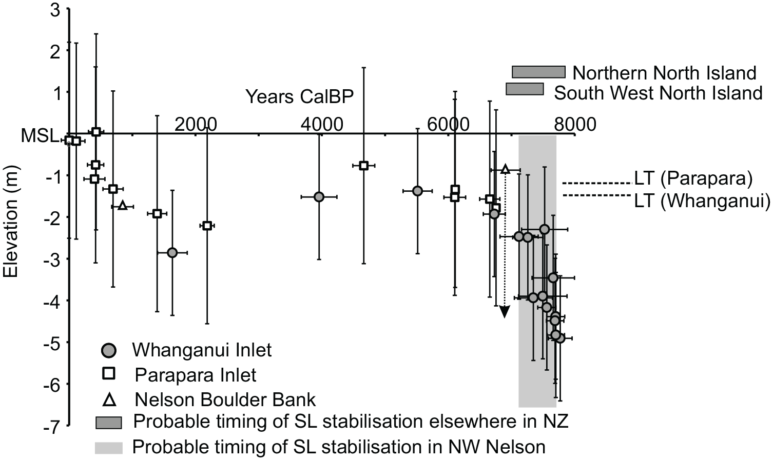
Relative sea level reconstruction for the north west Nelson region of New Zealand based on radiocarbon ages from Parapara and Whanganui Inlets. The ages from the Nelson Boulder Bank are from Dickinson and Woolfe (1997), with the oldest age being a reworked subtidal mollusc (Mactra discors). The time-series windows of the end of the PMT for tectonically stable sites in New Zealand are adjusted from Clement et al. (2016) using a delta R value of 0 for consistency with the calibration procedures used for the dated molluscs in this study.
A change in boundary conditions may have occurred at around 2 ± 0.5 ka, where dated samples are around 1.5 m lower than the mean low tide position, both in Whanganui and Parapara Inlets. Clement et al. (2016) identified a sea level fall to present elevations starting at 4 ka throughout New Zealand, while Larcombe et al. (1995) suggested a more rapid fall in the regional sea level around 3 ka based on proxies from the central Great Barrier Reef. While the coincidence of ages suggests sea level may have been a driver, it is also possible the lower elevation ages are representative of tidal channel migration across the established sediment flats. A single age of an intertidal Serpulid worm (Pomatocerus sp.) of 800 ± 161 at −0.92 m within the Nelson Boulder Bank (Dickinson and Woolfe, 1997) appears consistent with the ages from the estuaries (Figure 9) which lends some weight to the hypothesis of regional sea level change as a driver. Finally, the elevated ages found in Parapara after 0.5 ka, are very unlikely to be eustatic in origin but are almost certainly a product of sluice mining in the catchment.
The attainment of contemporary MSL elevations in north west Nelson at 8–7 ka is most like the patterns of eustatic change identified in the northern North Island and close to the south west North Island (Clement et al., 2016). In these locations, sea level attained present elevations at 8.1–7.3 and 7.8–7.2 ka respectively. It is worth noting that the age calculation of Clement et al. (2016) are based on a calibration using a delta R correction of −7 ± 45 which results in an age approximately 300 years older than the calibration delta R used in this work. The calculated timing of the end of the PMT is around 1 ka earlier than identified in the southern part of the South Island. We therefore suggest that the north west Nelson region, along with the northern North island, both being relatively stable tectonically, are most representative of eustatic curves for New Zealand and the southern Tasman Sea. The coring evidence from Whanganui and Parapara Inlets cannot shed further information on mid-Holocene highstand sea levels. Salt marshes on the margins of both systems may yield evidence of eustatic highstands, however at least within Whanganui Inlet proxies such as foraminifera are not well preserved (Millar et al., 2002).
Conclusions
The small barrier estuary of Parapara Inlet infilled in close association with sea level, forming a traditional tripartite facies distribution of fluvial and flood tide deltas and associated central basin. By the time of human settlement in the region in the late-Holocene the estuary had infilled to low intertidal elevations and was likely operating in a sediment bypass mode with a permanently open entrance maintained by the meso-tidal offshore hydrodynamic regime. The elevation and surface facies of the contemporary estuary are significantly affected by a short-lived sluicing industry in the late 1800 which raised the sediment flats to high intertidal elevations and significantly increased the size of the fluvial delta. The deposition of mining-derived sediment did not however change the broad facies distribution within the system. It is likely that the hydrological connection of the fluvial and marine systems buffered some impacts of mining as finer material could be transported through the estuary and offshore.
Sea level in the north west corner of the South Island of New Zealand, reached modern elevations around 8–7 ka most like tectonically stable sites in New Zealand on the northern North Island. The similarity between these areas suggests that this timing of the end of the postglacial marine transgression is eustatic in nature and can be therefore considered as a benchmark for coastal research throughout New Zealand. Evidence for a high mid-Holocene sea level stand was not found in the estuarine sediments of north west Nelson and this is likely a product of the estuaries being in a sediment bypass mode, rather than being evidence against the existence of a higher sea level.
Footnotes
Acknowledgements
Nicole Semple, Nick Mulcahy, Nicola Scott and the 2009 3rd year physical geography students at Victoria University of Wellington are thanked for assistance in collection of cores within Parapara Inlet. The assistance of Nick Boyens, Rachael Armour and Tim Baker for sampling within Whanganui Inlet is appreciated. The Department of Conservation (Takaka Office) is thanked for providing access to the field sites. Critical reviews by Catherine Chagué and Colin Murray-Wallace are much appreciated and significantly improved the manuscript.
Funding
The author(s) received no financial support for the research, authorship, and/or publication of this article.