
Abstract
Sediments of Lake Lubińskie were investigated to track human-induced vegetation and fire activity changes in Lubusz Land (western Poland). Geochemical data, as well as pollen, macrocharcoal, and statistical analyses (CONISS, CharAnalysis, PCA, BINCOR) allowed us to recognize the major phases of the human impact. At the beginning of the investigation period, 3000 years ago, the area had already experienced disturbances from humans caused by the Lusatian and Przeworsk cultures, followed by western Slavs, and modern society. Land cover changes were mostly related to deforestation and gaining arable lands. The forest communities shrank substantially also due to timber demand from the growing society. However, the pollen record shows that within the last ~50 years the area experienced forest regeneration. Wildfires played an important role in shaping the landscape in the area of Lake Lubińskie. Overall, 23 fires were identified within the profile showing relatively high fire frequencies (up to 4.8 fires per 500 years) between 600 −38/+36 BCE and 1 ± 206 CE as well as between 1065 ± 98 CE and 1380 ± 92 CE. The highest fire frequency was observed between the 1000s and mid-1400s, showing decreased fire return interval (FRI) and increased charcoal flux as well as progressive deforestation. These changes were related to the establishment of villages (e.g., Lubin village) and the presence of the Joannites. Fire was most commonly used as a land management tool to gain patches of land for agrarian purposes. PCA and BINOCR analyses suggest that most of the fires were set by humans, but natural causes of ignition cannot be excluded. The land-use changes affected the vegetation in the region, causing increased erosion and shifts in the geochemistry of the lake reflected in better bottom waters ventilation and progressive eutrophication.
Keywords
Introduction
Well before the appearance of humans on Earth, fire played a key role in the origins of plant adaptations as well as in the distribution of ecosystems and thus it is considered a natural component of many environments (Bowman et al., 2009). However, since the advent of humans and the rise of human civilization, people have heavily influenced fire regimes, often in ways that have greatly affected the sustainability of some ecosystems. Therefore, fire reconstructions are required to understand ecosystem dynamics in many regions of the world. Although an increasing number of studies focuses on how coupled climate- and human-induced changes influence fire frequency and fire behavior in traditionally fire-prone regions, this has largely been underexplored in regions considered not prone to fire, such as the extensive European lowlands. This is due either to the assumed low flammability of the vegetation or to past weather and climatic conditions not being conducive to ignition and spread of fire (Adámek et al., 2015). Meanwhile, more and more studies show that fire has been an integral part of the vegetation transitions and was involved in shaping European ecosystems throughout the Holocene (Bonk et al., 2022; Carter et al., 2018; Dietze et al., 2018, 2019; Kołaczek et al., 2016, 2020; Marcisz et al., 2015, 2017). This is because of frequent droughts and dominating air masses during the early Holocene and accelerated human evolution after 8500 cal. BP (Dietze et al., 2018).
Forested areas worldwide have undergone significant transformations due to human activity, thus a majority of the global land surface is managed as croplands, pastures, and production forest (Erb et al., 2007). In Europe, only small isolated patches of forests are considered “natural” (Jaroszewicz et al., 2019). The ecological footprint of hominin activities in Central European lowland forests has been dated as early as to the Last Interglacial period, approximately 125,000 years ago (Roebroeks et al., 2021), and is associated with the use of fire and influence on vegetation structure by Neanderthals. During the early Holocene, forest resources in Europe, including the Polish lowlands, were extensively explored by Mesolithic hunter-gatherers, using fire and changing the composition of local forests (Makohonienko et al., 2023). Forest transformations have been intensified by agricultural communities. In the sixth millenium BCE, the Neolithic economy spread north of the Carpathians into the environment of the loess uplands and lowlands of Poland (Czekaj-Zastawny et al., 2020). The use of fire was continuously practised by the Neolithic and Bronze Age societies (Moskal-del Hoyo, 2021). Pędziszewska et al. (2020) has recently synthesized the patterns of changes in vegetation, land-use and settlement dynamics reflected by pollen data on vegetation in northern and central Poland during the first millenium of the Common Era (CE), indicating regional anthropogenic transformations of landscapes during the Roman Period, reforestations during the Migration Period and vast-scale landscape transformations during the Early Medieval. One of these areas is western Poland, which has experienced several political and economic turnovers affecting the vegetation cover and land-use. Although the history of the settlement in western Poland is relatively well-known and it was shown that the human activity has been a main driver of fires (Bonk, 2019; Czerwiński et al., 2021; Lamentowicz et al., 2020), these conclusions do not include effects of fire regime on the ecosystem and transitions into human-dominated landscapes over the long timescale. The sediment record of Lake Lubińskie may add some value to these considerations and extend the understanding of the changes beyond the Migration Period. The lake has been chosen for investigation, as it is located in western Poland and, to date, provides the longest varved chronology in this region, what allows filling the gap between western and eastern parts of Europe.
In this paper, we intend to investigate the past land-use and fire activity in Lubusz Land (western Poland), define the fire causes and assess the fire influence on the landscape. Therefore, we address the following research questions:
What was the main driver of the vegetation change over the last 3000 years in Lubusz Land (western Poland)?
Were forest fires an important component of the land management?
What was the effect of the land-use changes on the ecosystem?
To answer these research questions, we performed geochemical, palynological, and paleofire investigations of sediment cores collected from Lake Lubińskie, western Poland. Here, we investigate conditions after human-derived changes in the catchment, the role of fire in shaping the ecosystem, and the sedimentological consequences of anthropogenic activity in this region.
Materials and methods
Study site
Lake Lubińskie is a eutrophic lake located in Lubusz Land (western Poland; Figure 1a; 52°18.5′N, 14°54.5′E) within a postglacial valley. The lacustrine deposition started after the last glaciation and is reflected in 10 m-long sediment profile. Quaternary deposits in the catchment (a total area of 4.26 km2) are dominated by tills, glacial sands and gravels (Sztormwasser, 2005). The vegetation nowadays consists of coniferous forests composed mainly of pine with an admixture of broad-leaved trees such as oak and alder. The climate of the region is temperate with oceanic influences. The mean annual temperature is 10°C, and the total annual precipitation is 600 mm (1981–2010; Institute of Meteorology and Water Management, 2021, https://www.imgw.pl/).
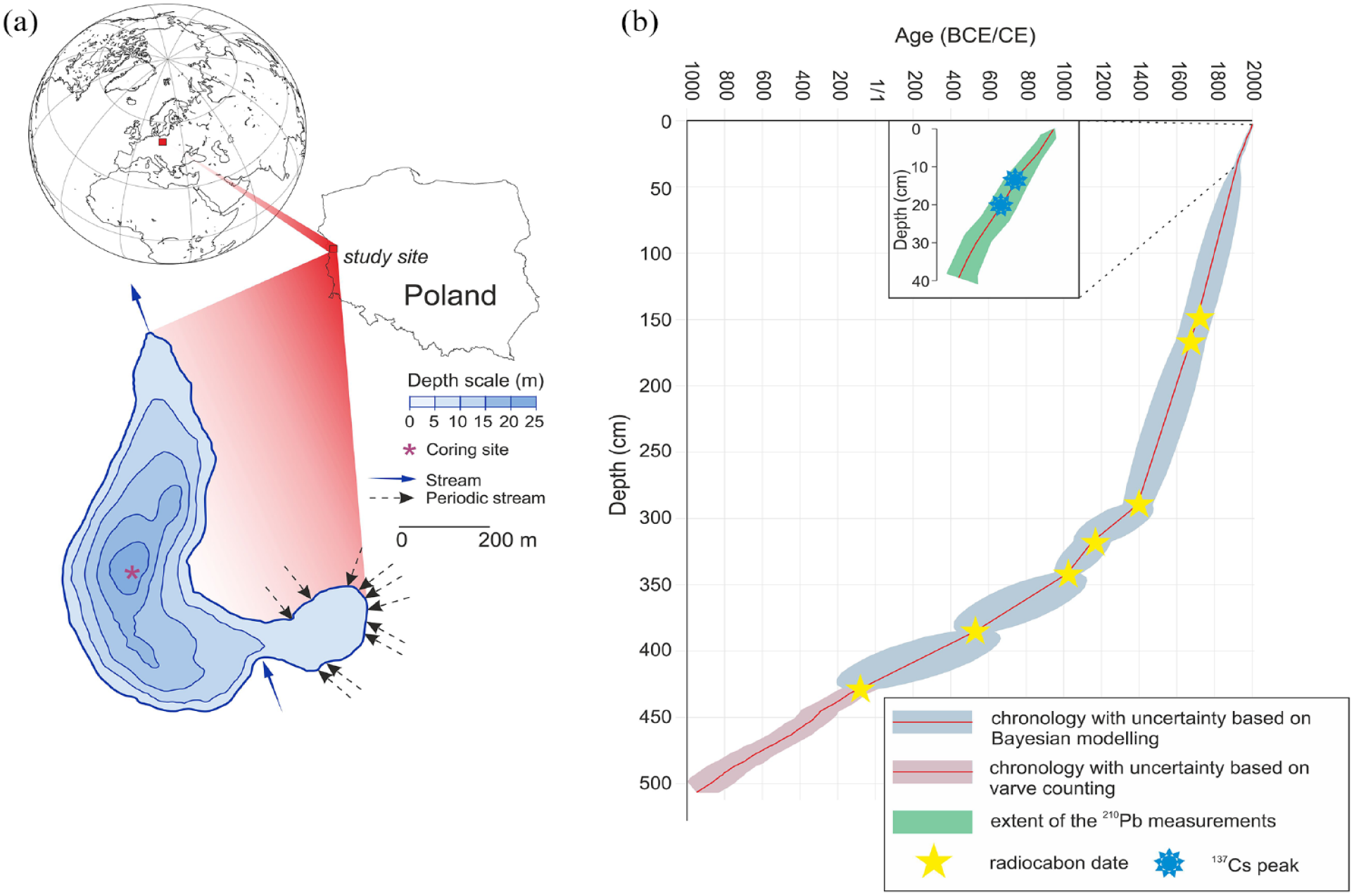
Location and bathymetry of Lake Lubińskie (a) and chronology with uncertainty for the studied record (b).
The lake has a small surface area (22.7 ha) and a simple bathymetry. The deepest point of 21.6 m is located in the central part of the lake (Figure 1a). The mean water depth is 8.8 m. The lake is fed by several periodic streams along with the groundwater, and has one outflow in the northern part. The lake is naturally eutrophic (Bonk et al., 2023), with anoxic conditions at the water-sediment boundary during most of the year.
Chronology
The chronology of Lake Lubińskie sediments has been already established using a combination of varve counting, radiocarbon dating, and age-depth Bayesian modeling (Bonk et al., 2023). The results showed that the investigated core covers the time period from 2007 CE (the year of coring) back to 946 +113/−144 BCE (Figure 1b). The symmetric uncertainty appears from the top of the profile to the depth of 428 cm, where the last modeled age from terrestrial remains was obtained. Below this depth, the uncertainty is asymmetric due to the varve counting technique described by Bonk et al. (2016).
XRF scanning
High-resolution X-ray fluorescence scanning (XRF) was performed on the surface of the fresh sediment core split lengthwise. To obtain semi-quantitative geochemical data, the ITRAX XRF Core Scanner (Cox Analytical System) was used (Croudace et al., 2019). Raw element counts were transformed to log-ratios using the R library “robCompositions” 2.3.0 (Templ et al., 2011). This transformation provides element ratios linearly related to log-ratios of absolute concentrations, and therefore provides information on relative changes of measured values.
Elemental analysis
In order to determine amount of total carbon (TC) and total nitrogen (TN), 278 samples were analyzed using a CNS elemental analyzer (Vario EL Cube, Elementar) equipped with a thermal conductivity detector (TCD). The concentrations of total inorganic carbon (TIC) were measured with a SoliTIC (Elementar) module coupled to the elemental analyzer. Details of the sample preparation steps can be found in Bonk et al. (2023). Total organic carbon (TOC) was calculated by the subtraction of inorganic carbon from the total carbon. Variations of C:N ratios within lake sediments show changes in the sources of organic matter at the lake bottom (Kaushal and Binford, 1999), therefore we use TOC/TN ratio to present estimates of the terrestrial material delivery (higher ratio) versus organic production in the lake (lower ratio).
Pollen, non-pollen palynomorphs, and macrocharcoal
A total of 48 samples with a volume of 1 cm3 were used for pollen analysis. The samples were prepared according to the standard procedure (Berglund and Ralska-Jasiewiczowa, 1986). The prepared pollen slides were examined until a minimum of 500 tree, shrub and terrestrial herbaceous pollen grains was reached in each sample (AP + NAP = 100%, excluding Cyperaceae). The simplified pollen diagram has been already published (Bonk et al., 2023), thus the extended version is presented herein.
Next to dominant trees and shrubs taxa, pollen spectra were divided into 10 ecological groups: (i) trees and shrubs on wet habitats, (ii) light-demanding trees and shrubs, (iii) shade-tolerant trees and shrubs, (iv) forests and ferns, (v) general apophytes, (vi) fresh meadows and pastures, (vii) wet meadows, (viii) ruderals, (ix) weeds and cultivated fields, and (x) cultivated plants.
The sediment profile was continuously sampled for macroscopic charcoal (MAC; ⩾150 µm). The samples of 1 cm3 volume were then bleached to create more visible contrast between the charcoal and the organic matter remains. The carbonates were removed from the sample with 10% HCl. Afterward, samples were gently sieved and the charcoal particles were counted under stereoscopic microscope with 40–60× magnification. The macrocharcoal was then divided into three size groups: MAC150 (150–300 µm), MAC300 (300–500 µm), MAC500 (>500 µm). Due to their location within slump deposits, 12 samples were removed from analysis. Charcoal accumulation rates (CHAR, particles cm−2 year−1), fire frequency (# fires 500 year−1), peak magnitude (# peaks cm−2 peak−1), fire return interval (FRI; year fire−1), and local fire episodes were obtained with CharAnalysis software (Higuera, 2009). Prior to the analysis, all MAC values were shifted by a constant value (1) and transformed via log10. The background was determined by applying robust, locally weighted regression (LOWESS) with a moving-window width of 300 years (SNI > 3.0; Kelly et al., 2011). Peaks were calculated as residuals with a locally defined threshold.
Statistics and visualization
The data were analyzed using R 4.1.2 (R Core Team, 2021). Pollen spectra and stratigraphically constrained cluster analysis (CONISS; Grimm, 1987) were analyzed and plotted in a diagram using R package riojaPlot 1.03. The mean variability directions of the pollen percentage and XRF data were obtained with principal component analysis (PCA), visualized with ggplot2 3.3.5 (Wickham, 2016). Before the PCA raw XRF data was recalculated to means to correspond with the CNS data time intervals. The clr were then calculated. All geochemical data was scaled and centered. To test the correlation between unevenly spaced time series of charcoal, arboreal pollen, and cultivated plants, the BINCOR 0.2 package was used (Polanco-Martínez, 2018).
Results
Downcore variability of geochemical features
The results of geochemical analysis are plotted according to the chronology and divided into two groups: CNS elemental analysis results and XRF-detected elements (Figure 2). The composite profile of the total length of 506 cm consists of gyttja with calcareous lamination. The sediment record is almost entirely varved, except for three massive layers of the erosive nature. Organic matter content is shown by TOC and exhibits a variable pattern throughout the profile with the highest fluctuations between ca. 100 and 1100 CE with the maximum value of 20.5% ca. 740 ± 236 CE. The lowest value of 3.2% is observed ca. 1100 ± 106 CE. The majority of TOC/TN values range between 8 and 10, but at the depth corresponding to the higher TOC the ratio reaches values up to 14. Calcium (Ca) and strontium (Sr) show similar pattern throughout the profile, although Sr seems to be less variable. Overall, the largest fluctuations are observed between ca. 200 ± 92 BCE and 1250 ± 150 CE. After ca. 100 ± 270 CE contents of Sr and Ca had been gradually decreasing, with some fluctuations, until an abrupt increase ca. 1900 ± 38 CE. Lithogenic elements such as potassium (K) and titanium (Ti) exhibit similar patterns with lower values centered around three periods: from the bottom of the profile until ca. 800 −141/+111 BCE, 1 ± 200 CE–800 ± 236 CE, and after 1850 ± 66 CE. The detrital content is highest between 1300 ± 146 CE and 1850 ± 66 CE. The ratio of redox-sensitive elements, iron (Fe) and manganese (Mn), shows the most distinct pattern among all presented geochemical proxies. The Mn/Fe ratio is lowest in two periods: 1 ± 200 CE–350 ± 270 CE and 700 ± 230–950 ± 168 CE. The highest, in turn, is indicated from the beginning of the 1000s CE upward within the profile.
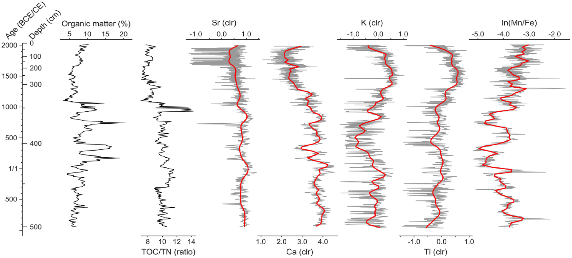
Geochemical features of the Lake Lubińskie composite profile. CNS data were interpolated, while XRF data shows yearly means. Red lines indicate smoothed time series.
Pollen zones of detectable pollen types
Based on CONISS analysis, we divided the pollen record into four zones (Figure 3). Within the zone 1 the highest pollen percentage is observed for trees and shrubs of light-demanding taxa with Pinus and Betula having the highest share. A distinct peak of Corylus pollen at 494 cm (819 +22/−57 BCE) of the composite depth is also observed. The same share of trees and shrubs (Alnus and Salix) on a wet habitat as well as shade-tolerant species (mostly Quercus, Carpinus, and Fagus) are observed and reached up to 20% of the total sum of pollen in this zone. A significant drop of Alnus pollen percentage is observed ca. 900 ± 204 CE. Fresh meadows and pastures, general aphophytes, and ruderals indicators are relatively abundant reaching up to approx. 20%.
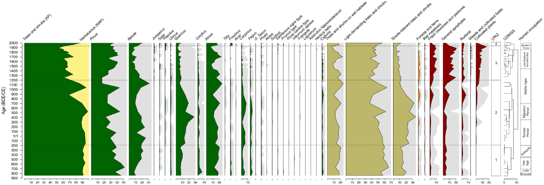
Pollen diagram of selected taxa, local pollen assemblage zones (LPAZ), stratigraphically constrained clustering (CONISS), and human occupation phases.
Zone 2 is more variable than zone 1 and the clear decrease of percentage of light-demanding trees and shrubs occurs ca. 700 ± 230 CE. However, around 1050 ± 52 CE their share increases up to 65%. Pollen of the wet habitats indicators vary around 20% throughout the zone except for a clear drop around 400 ± 246 CE and 900 ± 204 CE. At the same time, pollen of the shade tolerant trees and shrubs reach their maximum percentage of 30% around 400 ± 246 CE and 700 ± 230 CE. After that, there is a constant and gradual decrease of their share upward within the zone. Cultivated plants pollen indicators appear in this zone first around 300 ± 286 CE and next around 500 ± 148 CE. Their maximum percentage in this zone is observed at the topmost part, but even there, their share is low, accounting for to approx. 5%. However, there is a significant increase in share of pollen related to the human activity in the area observed, especially in ruderals and general aphophytes pollen.
Although the share of Betula pollen within zone 3 decreases from 30% to 5%, light-demanding trees and shrubs pollen indicators are still the most abundant group due to the increased share of Pinus. In approximately 1700 ± 78 CE Alnus pollen percentage reaches maximum values of 30% and decreases toward the top of the zone. The share of shade-tolerant pollen decreases gradually from the beginning of the zone. One distinct peak is noticed around 1800 ± 78 CE, which is related to the slight increase of Quercus pollen. The biggest changes are observed within human activity-related indicators. All of them indicates an abrupt increase at the beginning of the zone and remain relatively high.
Zone 4 covers the most recent period and is characterized by a rapid increase of arboreal pollen percentage. The biggest change is observed for Betula and Alnus pollen and slightly less pronounced for Populus and Fraxinus pollen. Ruderal pollen remind at the same level as in zone 3, while other human activity-related indicators show a decreasing trend toward the top of the profile.
Fire activity reconstruction
To reconstruct the fire history of Lubusz Land over the last 3000 years (Figure 4), we analyzed charcoal content in 506 samples. In 289 of the 506 samples (57.1%) we found at least one piece of macrocharcoal. The SNI exceeds the critical threshold of 3.0, confirming the record is suitable for peak-detection analysis. Overall, 23 fires are identified within the record (Figure 4e, red crosses), showing relatively high fire frequencies (up to 4.8 fires per 500 years) between 600 −38/+36 BCE and 1 ± 206 CE as well as between 1065 ± 98 CE and 1380 ± 92 CE. At the same time, the highest frequency of fires is observed, reaching the value of 6.4 fires per 500 years and reflecting the local-to-regional biomass burning trends. The highest peak magnitude (34.4 pieces cm−2 peak−1) is observed in 1095 ± 106 CE. Reconstructed fire return interval (FRI) suggests an average of 125 years between successive fires. The longest period without fires are observed between 1419 ± 86 CE and 1956 ± 10 CE and is calculated to have lasted 537 years. The second longest period with no fire observed lasts for 240 years and occurs between 261 ± 294 CE and 501 ± 146 CE. Fluxes of 150–300 and 300–500 µm charcoal pieces are close to zero until about 1350 ± 92 CE, and around 1 after that, with peaks up to 4 pieces cm−2 yr−1. Slightly increased values are also observed around 600 −128/+106 BCE, 300 −101/+95 BCE and between 700 ± 228 CE and 1200 ± 136 CE. The flux of charcoal bigger than 500 µm is low during the whole time (values not exceeding 1 piece cm−2 year−1) and no characteristic fluctuation has been observed.
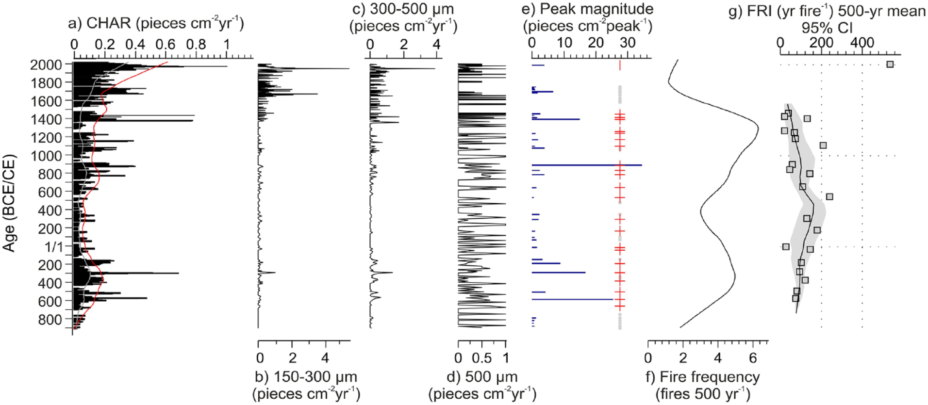
Reconstructed fire history for Lake Lubińskie based on macrocharcoal flux (CHAR; a), charcoal pieces of different size (b–d), peak magnitude and fire events (red crosses) (e), smoothed fire-frequency (f), and fire return interval (FRI; g).
Statistical analysis
The study analyzed the relationships between different variables representing both sedimentation processes in the lake and land-use change in the catchment (Figure 5). The PCA explain 64.1% of the elements’ variance (38.7% PC1 and 25.4% PC2) and can be divided into three groups. The first group includes elements that are negatively correlated with the PC1 and are related to allochthonous input (K, Ti). The second group consists of elements positively correlated to PC1 and represent autochthonous processes as calcite precipitation (Ca, Sr, TIC) or diatom abundance (Si) and changes within the oxygenation (ventilation) of the lake bottom (Fe, Mn). The third group is represented by proxies positively correlated with the PC2 indicating the lake productivity (TC, TS, TOC, TN). The PCA performed for pollen data shows that the pollen taxa can be divided into four groups. PC1 and PC2 explain 43.6% of the variance (31.7% PC1 and 11.9% PC2). The first group includes taxa positively correlated to PC1 and is related mostly to the human activity. The second group, negatively correlated with the PC1, represents taxa of natural forest communities. Only one taxon (Pinus) is positively correlated to the PC2, while on the other end are taxa related to abandoned lands and tree species of various habitats.
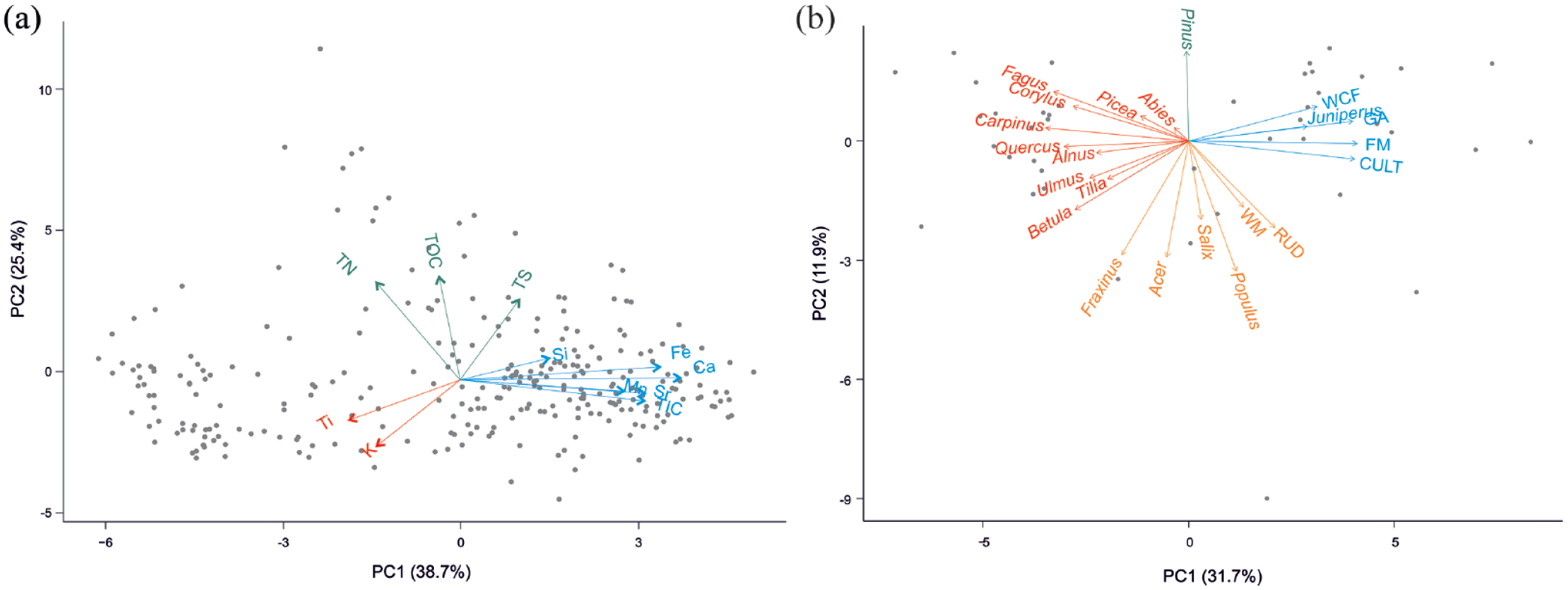
Principal Component Analysis (PCA) biplots: geochemical proxies with reduced XRF dataset (a) and selected pollen taxa (b). Colors indicate correlation with PCs; blue – positively correlated with PC1, red – negatively correlated with PC1, green – positively correlated with PC2, orange – negatively correlated with PC2. Abbreviations on the (b) biplot: WCF: weeds and cultivated fields; GA: general aphophytes; FM: fresh meadows and pastures; CULT: cultivated plants; RUD: ruderal habitats; WM: wet meadows.
The correlation of data series revealed that the correlations between CHAR and AP and CHAR and cultivated plants indicators are statistically significant and are equal to −0.35 (α = 0.1, df = 28, p = 0.06) and 0.46 (α = 0.05, df = 28, p = 0.01), respectively.
Discussion
The forest composition over the last 3000 years shows a relevant anthropogenic impact in the vicinity of Lake Lubińskie. Results of palynological analysis show that composition of pollen taxa reflect local conditions at the beginning of the investigation period. The pollen catchment expanded most likely as a response to land openness due to human activity. The results of pollen analysis indicate human occupation near the lake from the late Bronze Age until the present with only short period of abandonment of the land (Figure 6). The discussion of vegetation change is structured according to the history of settlement in the area rather than as suggested by CONISS. This is due to different scales of anthropogenic pressure depending on the stage of the society advancement.
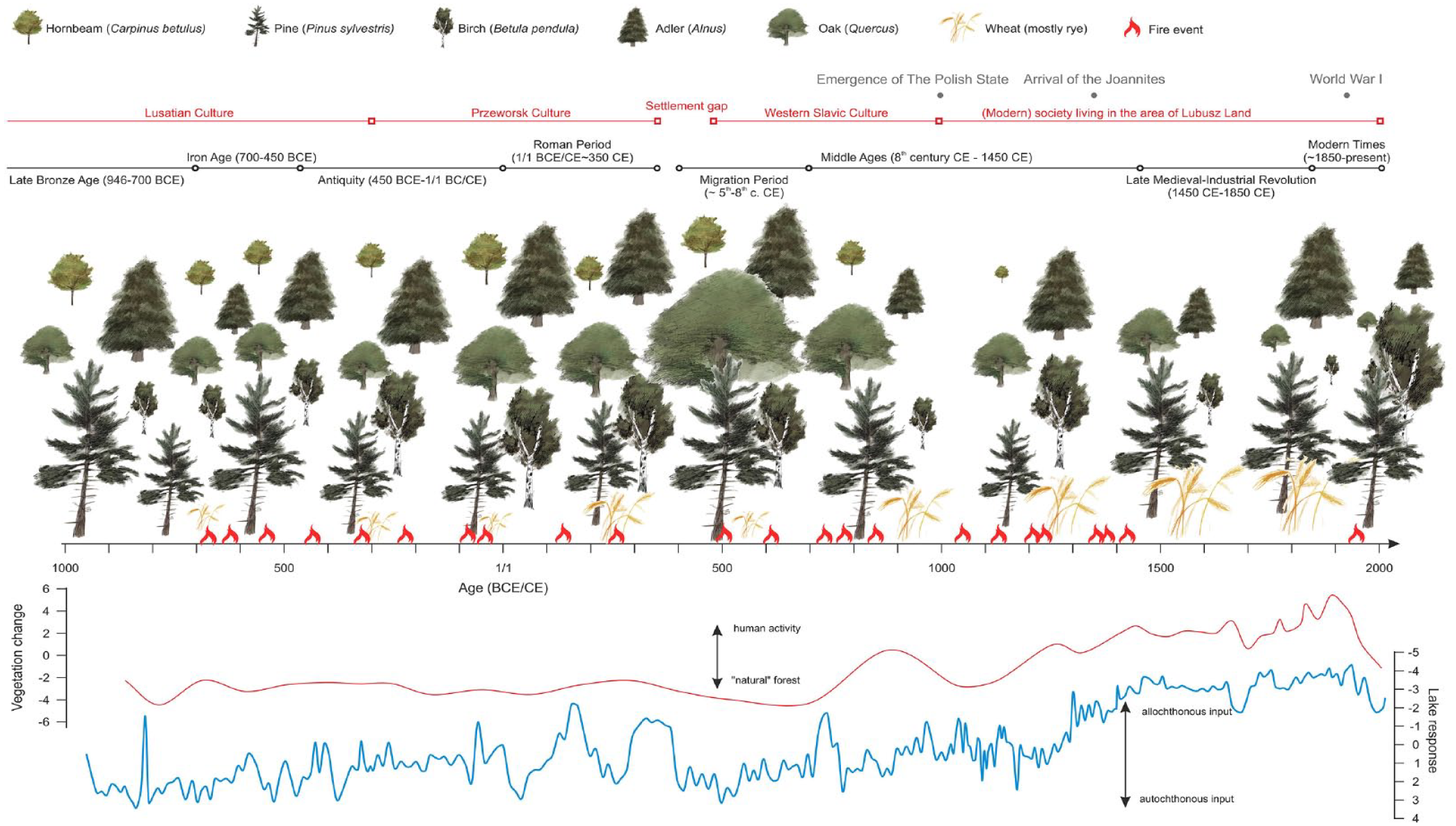
Distinct phases of human settlements, land transformation, and type of material deposited at the bottom of Lake Lubińskie. The size of distinct species presents a relative abundance of materials. Red and blue curves reflect vegetation change and lake response derived by PC1s of PCAs.
Historical human pressure on forested areas and vegetation change
Late Bronze Age (946–700 BCE) – Iron Age (700–450 BCE)
The pollen record indicates that vegetation of this period was dominated by the light-demanding trees and shrubs with an admixture of plants growing on wet habitats as well as some shade-tolerant species. Pine was dominant in this period with a high contribution of oak and an ever-present admixture of birch. It suggests the predominance of pine forests and oak forests as natural vegetation on terrestrial habitats. Pine and oak may have formed a mixed forest phytocoenoses as well. High representation of alder indicates the presence of wet forests on habitats around the lake. However, despite the absence of cultivated plants, pollen spectra, especially aphophytes and ruderal taxa, suggest that the region had experienced human occupation. The increase of light-demanding Betula starting around 700 BCE, could suggest the development of more open cultural landscape with mosaic vegetation after construction of strongholds by the Lusatian Culture in the mid-700s BCE (Kaczmarek, 2017). Less vegetation is, to some extent, confirmed by higher erosion rates (increased Ti, Figure 2) and more oxygenated bottom water of the lake (increased Mn/Fe ratio, Figure 2).
Antiquity (450 BCE–1/1 BCE/CE) – Migration Period (ca. 401–701 CE)
Continuously and distinctly increased values of birch are most likely related to human activity as a result of forest clearings and the development of ecotone zones inhabited by birch trees. Their development correlates with increased charcoal indicating the burning of vegetation (Figure 4), as well as with the signs of eutrophication (Bonk et al., 2023).
The Lusatian Culture was replaced by the Przeworsk Culture around 300–200 BCE. Their economy was based on animal husbandry, hunting, fishing, and farming (Kontny, 2016). We hypothesize that the belt of alder forest around the lake formed a sort of curtain partly preventing air-transport of pollen grains from low growing herbaceous taxa from habitats in further surroundings of the lake. It explains also the findings of cereal pollen grains, which were rare. However, their shares increase in the period of introducing rye into cultivation (due to the characteristic ease of this cereal’s wind-borne pollination) – first in the early Iron Age, then in the settlement phase of the Antiquity period and Roman influence. Finally, cereal pollen grains gained significant importance in the Early Medieval Period associated with the Slavic colonization. The agriculture led to the increased delivery of terrestrial material to the lake bottom (increased TOC/TN; Figures 2 and 6) which is also reflected in the better ventilation of bottom waters (Figure 2 and Bonk et al., 2023). However, before the western Slavic tribes arrived in the area of Lake Lubińskie, the pollen data suggests some forest recovery (ca. 400–600 CE). This includes mainly pine but an increase was also observed for oak, beech, and hornbeam. The share of herbaceous plants dropped to the minimal values of approx. 2%. Although high uncertainty of the chronology doesn’t allow to precisely link our record with the others, some insights are provided by pollen stratigraphy. For instance, regeneration was related to the Migration Period most likely and was observed in many other sites (Czerwiński et al., 2022). There were multiple reasons for this migration, including the arrival of nomadic groups and climate change causing harsh conditions for living (Bursche et al., 2020). The weakening or disappearance of settlements opened the way for the regeneration of forest cover observed in other sites (Pelisiak and Rybicka, 1998). Our data support this process, as around 500 CE, no pollen indicators of cultivation were noticed, confirming that the land was most likely abandoned, providing opportunity for forest to expand. Denser forest cover stopped erosion, which is indicated by low values of K and Ti (Figures 2 and 6). This is also confirmed by lower values of TOC/TN informing that less terrestrial material entered the lake (Figure 2). Moreover, higher Ca values along with less organic matter reflect colder climatic conditions (Bonk et al., 2023). Interestingly, the better ventilation of hypolimnetic waters was indicated by higher values of Mn/Fe (Figure 2) (Naeher et al., 2013; Żarczyński et al., 2019).
The Middle Ages (ca. 700 CE–1450 CE)
The area was highly forested until the beginning of the eighth century, when the Slavic Culture started deforestation (Szymoniewski, 2016). The pollen record is in line with the forest decline in northwestern Poland and was indicated mainly by the decline of hornbeam, beech, and, to some extent, oak, suggesting loss of the nearly pristine nature of the oak-hornbeam forests at that time (Czerwiński et al., 2022). Deforestations of oak-hornbeam phytocenosis due to human impact in prehistoric and the Early Medieval Times have been broadly discussed for the territories of western Poland (Makohonienko, 2000; Ralska-Jasiewiczowa et al., 2004; Tobolski, 1990). After deforestations, their habitats had been used for crop cultivation. This is also true for the Lake Lubińskie record (Figures 3 and 6), which shows land transformation and increased human impact ca. 890 ± 210 CE. The progressive decline of Quercus could have been an effect of increased demand for timber, as oak was the primary material used in the construction of the Early Medieval strongholds in Poland (Cywa, 2018).
As suggested by the other authors (Strzelczyk, 2003), the decrease of hornbeam trees after ca. 800 CE most probably abounded in situ and burnt to provide ash for soil enrichment in nutrients especially for the millet cultivation that was common among the early Slavs in the region. The hornbeam trees could be eliminated in an easy way by girdling, that is, partly removal of bark around the trunk resulting in death of the tree and its slow drying. Dried trees, even still standing at the spot, could be subsequently removed from the surface with the use of fire. Ethnographic records confirm that hornbeam wood was used in historical times mainly for fuel and for producing charcoal, for example, for the needs of glassworks (Surmiński, 1993).
A similar approach to wooden resources in Medieval Period might have been practised in the environs of Lake Lubińskie but on a smaller scale, as oak-hornbeam forests in the area were limited in favor of coniferous and mixed forests. The human impact on coniferous pine woodlands is visible in the increase of juniper in the pollen diagram (Figure 3). Its spread in the landscape was due to conifer forests clearings in the Medieval Period and to animal husbandry, as juniper is a bush resistant to grazing by cattle or goats and sheep. Juniper has remained a common component of the undergrowth in coniferous forests of the region to the present day.
Pollen stratigraphy indicates that ca. 900 CE, there was a significant decrease in the share of the alder that is observed in other parts of Europe (Latałowa et al., 2019; Stivrins et al., 2017), suggesting climate and pathogen outbreak as drivers of this change. In case of Lake Lubińskie, this process could have been perhaps strengthened by the clearings of the shore vegetation to gain access to the lake (Makohonienko, 2000). Alder was used as construction wood in water-logged conditions and to produce everyday objects such as scoops, ladles and beaters but also shields, knives, spoons, and kitchen utensils because its wood is fairly homogenous and soft enough to be worked (Cywa, 2018). Despite that, an increasing population and settlement activity during the period of formation of the Polish State around 1000 CE had rather little influence on the decrease of alder population. The decline of Alnus at that time was also observed in the nearby Pawski Ług peatbog (Lamentowicz et al., 2020), in the Kazanie mire (Czerwiński et al., 2021) a bit further to the east, and in Lake Gościąż (Pelisiak and Rybicka, 1998). The deforestation of the area progressed over the course of the following centuries, which is reflected in increased varve thickness, which itself reflects intensified erosion in the catchment (increased K and Ti, Figure 2).
The intensive development of the society in the oldest phase of the Early Medieval Period led to further tree stands decline. The observed in pollen record domination of pioneer birch at that time was most likely related to its extension to the areas where the pine forests were cleared. The other land-use changes are exhibited in the increasing share of meadows and pastures pollen indicators, which was related most likely to the growing economy and the founding of new villages. For instance, the village of Lubin, located approx. 0.5 km south from the Lake Lubińskie, was first mentioned in 1329 CE (website of the Village Council; www.torzym.pl) which corresponds to further deforestation of the area. The deforestations were also related to the change of economic activity of medieval societies due to the new rulers, the Knights of the Order of St. John (the Joannites), who arrived in the area in 1350 CE (Lamentowicz et al., 2020) and ruled over next five centuries, until 1812 CE.
The Late Medieval (1450 CE–1850 CE)
The vegetation composition changed showing increasing percentage of the cultivated plants and decreasing share of trees and shrubs as a response to the economic transformation in the area. The increase of cultivated plants was slow but continuous, suggesting permanent presence of settlements near the lake and demographic growth. However, the intensification of animal husbandry and land transformation from forested areas to meadows and pastures, led to increased landscape openness. A similar pattern of open vegetation spread and increased indications of pine during this same time was observed in other Polish regions, as for instance in the regions of Greater Poland (Czerwiński et al., 2021; Lamentowicz et al., 2020; Pleskot et al., 2022), Masurian Lakeland (Bonk et al., 2016; Wacnik et al., 2014, 2016), and in the areas around Suwałki (Bonk et al., 2022; Kinder et al., 2019; Marcisz et al., 2020). Pawski Ług (Lamentowicz et al., 2020) and nearby Lake Lubińskie experienced a collapse of broadleaved tree species, evidencing the destruction of the natural deciduous forests residues at the beginning of the 1400s. Mass deforestation and forest fragmentation were two of the most common disturbances in the landscape of Central Europe (Krawczyk et al., 2021). It is assumed that by the 1700s the forest cover in Poland had shrunk to 43% and to as little as 20.8% in 1945 CE (Szujecki, 2003). These processes are reflected in increasing erosion in the lake (increased K and Ti, Figure 2) and better oxygenation of the bottom waters (Mn/Fe ratio, Figure 2). These proxies suggest that due to less dense forest cover, wind-derived water mixing could have been more efficient.
The Industrial Revolution – Modern Times (~1850–present)
In the studied area, the most intensive influence on the environment and the increase of agriculture activity took place in mid-1800s and remained high until the beginning of the 1900s. The sudden increase of human impact could be also related to the development of large manor farms and to industrialization processes in the region of Lubusz Land (Lamentowicz et al., 2020). The need for reforestation had become apparent in the 1800s but the most intense actions were taken after World War I by restoring the tree stands destroyed during the war (Płoński, 1930). After World War II, in 1945 CE, a State Agricultural Farm (Polish: Państwowe Gospodarstwo Rolne, PGR) was established and directed to animal production (10,000 pigs per year, 100 dairy cattle, 2000 sheep; Construction, Real Estate and Environmental Protection Department in Torzym, oral information). There was also cultivation of cereal, oil plants, and root plants. The sown area in the vicinity of Lake Lubińskie was about 1500 ha. The forest cover had been progressively rebuilt with an observed increase of percentage of oak and birch, and accompanied by the decrease of cultivation indicators in the pollen diagram. A light-demanding species as birch (mainly Betula verrucosa), that occupies abandoned fields and the edges of forests, is characteristic of agricultural landscapes in the Polish lowlands with its mosaic landscape of forests and open-field vegetation. A narrow belt of swamp alder stands with ash, accompanied by willow and poplar thickets, presently surrounds Lake Lubińskie, which is also reflected in the pollen diagram (Figure 3).
The history of human-induced fires
The human occupation in the area of Lake Lubińskie started before the time covered by the sediment profile of this study. Our results show that the historical phases of human occupation reconstructed from the lake sediment are well synchronized with the occurrence of fire and with the forest structure. This is confirmed by the appearance of weeds, ruderals, pastures, and taxa showing cultivated fields throughout the whole period. Taking into account the agrarian techniques, it can be assumed that the majority of fires, if not all of them, were human-derived and were used as a land management tool. This is confirmed, to some extent, by the statistical analyses which revealed a moderate negative correlation between the charcoal flux and the abundance of arboreal pollen, and a moderate positive correlation between the charcoal flux and cultivated plants. These results suggest that tree communities were not severely impacted by the fire. Therefore, we hypothesize that forest clearance was done using the slash-and-burn technique, which has been an efficient way to obtain agrarian patches and to reduce the forest stands. The natural causes of ignition from lightning strikes cannot be excluded but as they occur at low frequencies, they seem less likely to be a fire trigger.
The first sign of humans in our record was Lusatian Culture, which exploited the local natural resources through cultivation and animal husbandry as well as hunting, gathering, and fishing (Kaczmarek, 2017). The land use included utilizing slash-and-burn technique to obtain arable land. Due to this practice, forests were burned and exploited until exhaustion and abandoned, or they were used in pre-determined rotation cycle regarding the capacity of soils (Kaczmarek, 2017). This is clearly reflected in the number of fire events and the variable erosion proxy, suggesting possibly increased allochthonous input to the lake after fire (Figure 6). The agrarian processes were continued by the Przeworsk Culture, which is reflected in number of fires at that time and in their increased frequency. However, the only minor changes within the forest composition suggest the fire episodes were not severe and most likely limited to ground fires, or that only a small selected patches of land were cleared for farming.
Although there was charcoal observed in the record during the Migration Period, it was most likely secondary charcoal, as its abundance was too low to pass the threshold necessary to qualify as a fire event. Fire frequency dropped to low values, which was related to lack of fire episodes observed for almost 250 years. The situation changed in the 500s CE, when the tribal period started with the arrival of the western Slavic Culture (Szymoniewski, 2016). This is further confirmed by the pollen stratigraphy of other site, Lake Wonieść, located ca. 120 km from Lake Lubińskie. There, settlement indicators were also increased, showing either the regeneration of small surviving population or new colonization (Dörfler et al., 2023). Our results confirm that once again, arable lands were obtained with fire. It is likely that the fire ca. 850 ± 224 CE was severe, as there was an abrupt decrease in AP and fire episodes became more frequent. The high peak magnitude fire, which occurred at that time, coincided with a rapid decrease of trees and shrubs and resulted in more meadows, pastures, and indicators of general human activity. It is unlikely, however, that fires at this time were severe given the decrease in forest cover which in turn may have been related to deforestation, drainage, and changing climate conditions. The cut wood was also used for the production of utensils. Moreover, wood (especially oak and pine) was in high demanded for fuel, tar production, and constructing buildings. Therefore, it might have been the reason of deforestation in the vicinity of the Lake Lubińskie, as there was an early Piast stronghold not far from the lake (Moździoch, 2016). The investigated period’s highest fire frequency was between the 1000s and mid-1400s, showing decreased FRI and increased charcoal flux as well as progressive deforestation. These changes were related to the establishment of villages (e.g., Lubin village) and the presence of the Joannites. The fire episodes had been observed in this area for around 100 years longer than in the nearby peatbog Pawski Ług, which since 1350 CE registered only regional fires (Lamentowicz et al., 2020). Therefore, the microcharcoal found in the peat deposits could have been attributed to the fires in the vicinity of Lake Lubińskie, suggesting the deposition of charcoal particles over a distance of 25 km.
The succeeding centuries brought further changes wrought by a deepening of the exploitation of the area. Unlike other areas, for instance the Masurian and Suwałki Lakelands, no fire was observed from the 1500s to the late 1900s. However, some samples were removed from the analysis, as they were located in the slump deposits (Bonk et al., 2023). The higher values in the 1700s could be related to the intensive burning of wood for heat, as it was the time of the Little Ice Age. The unfavorable climate would explain the decreased share of cultivated taxa.
The centuries following this period were characterized by the decreasing fire frequency, the last one of which was recorded in 1954 CE but whose drivers remains unknown. It could have been related to the setting a fire in wasteland, grassland, and cultivated areas to get rid of dried vegetation remnants, which is known to be a common practice among farmers.
Conclusions
We investigated a varved sediment record of Lake Lubińskie located in western Poland to reconstruct the past land use and the fire activity thereon, using sedimentological and geochemical features of sediment along with the pollen spectra and macrocharcoal analysis. In light of the results and findings of this study, we were able to formulate conclusions based on the research questions raised in the introduction section.
Our study shows that the area near Lake Lubińskie already experienced human occupation by the beginning of the investigation period, 3000 years ago. However, the most pronounced transition from nearly natural to human-dominated landscape in western Poland occurred after the Migration Period and the arrival of the Slavs. This shift was related first to the deforestation for arable lands and later also for timber, due to the increasing demands of a growing society. Therefore, the main driver of these changes was undoubtedly anthropogenic influence on the ecosystem, especially after the emergence of the Polish State in the 1000s CE.
As is shown by the macrocharcoal record, fire was important part of the land management at least since the appearance of the Lusatian Culture in the area. Most of the fires were related to human activity and the slash-and-burn technique, which was one of the most frequently used methods to obtain clear patches of land. None of the reconstructed fires, however, seemed to be severe, as changes within vegetation and charcoal do not have a strong correlation, in contrast to charcoals and cultivated plants indicators, which show a strong correlation.
The land use includes a variety of changes to the ecosystem. The appearance of humans led to irreversible transformations. Deforestations reduced the forest communities and caused soil erosion, and therefore increased terrestrial material delivery to the lake bottom. Further effects on the lacustrine ecosystem include changes in geochemistry as well as a shift in the bottom waters’ ventilation and accelerated eutrophication.
The fossil record especially for the last approx. 50 years shows signs of tree stands’ regeneration/development in the agricultural landscape – namely an increased representation of swamp forest vegetation around the lake, an increase of oaks in regenerated forests on terrestrial habitats, and an increase of birch in the mosaic open and forest landscape of western Poland in the Central European lowlands.
Footnotes
Acknowledgements
We would like to thank Karolina Bonk for drawing plant species for Figure 6. Dr Joanna Piłczyńska is thanked for macrocharcoal samples preparation. We would like to also thank Dr Maurycy Żarczyński and members of the NORPOLAR project for their work in the field, sediment core photographs, sharing sediment samples and results, and fruitful discussions. Dirk Enters and Bernd Zolitschka from the GOPOLAR Institute in Bremen, Germany are thanked for the XRF scanning. We thank two anonymous reviewers whose comments and suggestions helped improve this manuscript.
Funding
The author(s) disclosed receipt of the following financial support for the research, authorship, and/or publication of this article: This study is a contribution to a scientific project financed by the National Science Centre, Poland – No. 2019/32/C/ST10/00038.