
Abstract
The history of water management is closely intertwined with evolution of social structures. In particular, the emergence of rice farming and transition to sedentary life contributed significantly to the development of water management practices, with increasing labour and economic investments to build and operate water-management infrastructures. Here we present archaeological, archaeobotanical and geoarchaeological evidence of early water management obtained from the excavations of three early-to-middle Holocene sites in the upper and middle Huai River region (UMHR), including Hanjing from Sihong County of Jiangsu Province and Xielaozhuang and Zhangwangzhuang from Luohe City and Zhumadian City of Henan Province. Our 14C dates suggest multiple episodes of regional inhabitation in the UMHR region. Our results also reveal that the wells at Xielaozhuang represent some of the earliest attempts to ensure water consumption in the village, and importantly, the rice-field-like structures at Hanjing and Zhangwangzhuang are evidence of a more systematic effort to modify and transform local landscapes for rice cultivation and related economic activities. In line with the results from published phytolith studies, we found that the early experiment of rice cultivation altered local soil and hydrological conditions at these sites. These early forms of rice fields share some similarities in micro-and-macro- morphologies and represent successful adaptations to the low-lying plains that continued to have fluctuating hydrological regimes. The construction and operation of these wells, moats and rice-field-like structures stimulated collaboration beyond individual households and groups in these early-to-middle Holocene villages in the UMHR region and thus would have had profound social and economic ramifications.
Keywords
Introduction
Considerable research progress has been made on how the transition to agriculture stimulated diverse social and cultural developments across different environments of Neolithic China, thanks to the rapid accumulation of archaeological and palaeo-environmental data (e.g. Fuller and Qin, 2009; Fuller et al., 2009; Zong et al., 2007). These studies have illustrated the significance of changing food traditions to the evolution of prehistoric settlements, from the adoption of sedentism and the establishment of first agricultural settlements, to the emergence of prehistoric walled towns (Liu and Chen, 2012; Zhao, 2014, 2017; Zhuang, 2020; Zhuang and Fuller, In press). It is also evident that this evolution followed diverse trajectories within and between different environmental regions. The Lower Yangtze River region experienced, for instance, a gradual and protracted shift from a reliance on wild gathered plant foods such as acorns and nuts and rice cultivation during the first half of the Holocene to a predominant focus on rice farming from the late-Majiabang (6300–6000 BP), Songze (6000–5300 BP) to Liangzhu culture period (5300–4300 BP) (Fuller and Qin, 2010; Fuller et al., 2009). Situated between the Yellow River in the north and Yangtze River in the south, the vast Huai River basin encompasses diverse environments. Long overshadowed by historical narratives that primarily focus on the Yangtze River and Yellow River, the importance of the Huai River basin has been overlooked until recently with systematic environmental and archaeological surveys (Yang et al., 2016).
The upper and middle Huai River (hereafter ‘UMHR’) region has emerged as another centre that fostered an early development of rice farming in light of recent excavations and archaeobotanical research which show that the earliest domesticated rice appeared almost simultaneously at several sites over 8000 years ago, including the well-researched Jiahu and Shunshanji sites (Institute of Archaeology of Nanjing Museum and Sihong County Museum, 2014; Chi and Hung, 2013; Zhang C., et al., 2018a, Zhang J.Z, et al., 2018). It seemed that, however, these early rice remains were associated with different settlement structures, indicating different patterns of human adaptations to diverse local environments. The subsequent development of this early rice farming in the region remains elusive. Whilst some scholars believe that it enjoyed a continuous development and further expansion, especially to Shandong in the east (cf. Jin et al., 2014; Chi and Hung, 2013), it is unclear if the early rice remains in Shandong and the UMHR region were related to each other, not least because of the chronological hiatus that exists between these archaeological cultures. More critically, how do these early rice remains represent different scenarios of early adaptations to diverse and volatile Holocene environments in these regions? And was the early rice farming related to development of water management strategies and formation of diverse settlement patterns? These questions are directly relevant to the so-called ‘Neolithization of water’, a term that has been coined in recent research to refer to the increasingly close relationship between the harnessing and manipulation of water, and the transition to sedentary lifestyles and agricultural economies (Gebel, 2004; Mithen, 2010). Its development in prehistoric China is rarely discussed and its importance to the emergence of sedentary lifestyles is significantly understudied.
The Holocene hydrological and palaeoecological conditions in the UMHR region differ significantly from those in the semi-arid and subtropical environments in northern China and the Lower Yangtze River where millets and rice were first cultivated and subsequently domesticated, respectively. Also distinctive are the regional cultural traditions. Research at Jiahu (9000–7800 BP) shows that the surrounding environment was characterized by a mosaic of wetlands, alluvial plains and remnant loess tablelands (Henan Provincial Institute of Cultural Relics and Archaeology, 1999), and that the site might have been seasonally flooded (e.g. Fan et al., 2011). Similarly, excavation at Shunshanji (8500–7500 BP) has revealed one of the earliest moated settlements in prehistoric China (Institute of Archaeology of Nanjing Museum and Sihong County Museum, 2014). Its relatively larger scale suggests an early and systematic alteration of local environment for water management and other purposes. These new discoveries also raise several important questions: were the settlements and environments of Jiahu and Shunshanji typical during the early Holocene in the region, and how important water management-related facilities were in the development of these early villages? Excavations of three early-to-middle-Holocene sites of Xielaozhuang, Zhangwangzhuang and Hanjing in Henan and Jiangsu provinces expand our understanding of the evolution of settlement structure and its relationship with the Holocene environment in the UMHR region. Importantly, despite a pronounced chronological gap between these sites, all three sites possess some water-management structures. In this article, we present archaeological and palaeo-environmental evidence from these three sites and investigate how the water-management features became an integral part of the evolution of Holocene villages in this newly emerged, independent agricultural zone of prehistoric China.
Regional environmental and hydrological contexts
The UMHR region can be roughly divided into southern and northern parts. The southern part has more undulating terrains. It belongs to the northern subtropical climate and receives over 1000 mm annual precipitation. In contrast, the warm-temperate northern part sits on the vast, flat Huang-Huai Plain, with an average annual precipitation of 800–900 mm (Cao and Qi, 2014; Yang et al., 2016). Its flat, low-lying terrains are particularly susceptible to floods during the rainy seasons. The region’s Holocene climate was strongly influenced by the East Asian Summer Monsoons. It followed a typical three-staged development: a relatively cold and humid climate in the early Holocene, a warm and humid middle Holocene, and a decline in humidity and temperature during the Late-Holocene, although the exact timings of these climatic stages are debatable. For instance, different studies have suggested different timings of the onset of the Holocene Climate Optimum (Jiang et al., 2018). A recent synthesis by Jiang et al. (2018) examined pollen and sediment records and suggested that the Zhengzhou-Xingyang region and the Chaohu Lake region of the UMHR region entered the warm and humid period around 9100–8000 BP. The authors associated the peak of the Holocene Climate Optimum with the northward expansion of rice cultivation. It is widely speculated that this climate amelioration was punctuated by several climatic oscillations. Studies of spelaeothem records in the upper Huai River and surrounding regions, for instance, have identified several climatic fluctuations between 6000 and 5000 BP as the intensity of summer monsoons weakened (Mao et al., 2016; Ren et al., 2006). These events caused intensified annual and decadal rainfall fluctuations, and would have had significant impact on Holocene occupation in the region.
Geomorphological process in the UMHR region is characterized by semi-continuous alluvial aggradation due to the low-lying terrains and humid conditions. Associated with this was the formation of numerous lakes and wetlands across the region as the regional water table remained high whilst drainage was poor (Zhang et al., 2019). This process was notable along both the main Huai River and many of its tributaries, such as the Sha and Ying Rivers in the upper Huai River, as confirmed by the results of several regional drilling campaigns (e.g. Zhang et al., 2023). Wang et al. (2017) suggest that from the terminal Pleistocene to the early Holocene around the Haojiatai site in Luohe, not only was the deeply incised late-Pleistocene landscape completely levelled up, but also broad and flat alluvial plains were created by continuous alluvial accretion. Large-sized lakes and waterbodies were formed during the middle Holocene, followed by another period of rapid alluvial aggradation. Based on altitudes and drainage conditions from their systematic drilling data, Zhang et al. (2019) further divided the loess tablelands and alluvial plains in Luohe into several different zones. They concluded that floods, especially those that took place during periods of climatic oscillations, hindered human habitation, and it was not until the Late-Holocene that settlements started to spring up quickly in the region.
The Xielaozhuang and Zhangwangzhuang sites are located in Luohe City and Zhumadian City of the upper Huai River region (Figure 1). As one of the major tributaries of the upper Huai River, the Sha River runs across the central northern part of the city, whilst the Ying River flows to its north, parallel approximately to the Sha River. Sitting in the intermediate zone between the western Funiu Mountains and the eastern plains area, the city features diverse landforms, including mountains, remnant loess tablelands (60–80 m above sea-level) and alluvial plains (40–60 m above sea-level). The Xielaozhuang site was occupied during the Jiahu-Peiligang period (see Results for the chronology), with a distinctive-styled pottery assemblage including the double-earred jar and bowls. The Jiahu-Peiligang culture is considered an early centre of agricultural origins and sedentary life beyond the Yellow and Yangtze Rivers (Chi and Hung, 2013; Henan Provincial Institute of Cultural Relics and Archaeology, 1999). Archaeological remains at Zhangwangzhuang belonged to the typical Yangshao culture, by which time the Upper Huai River and nearby region such as the Nanyang Basin became an important region in the wider Yangshao culture sphere with developed agricultural economies and sophisticated settlement structures (Zhang et al., 2018a, 2018b).
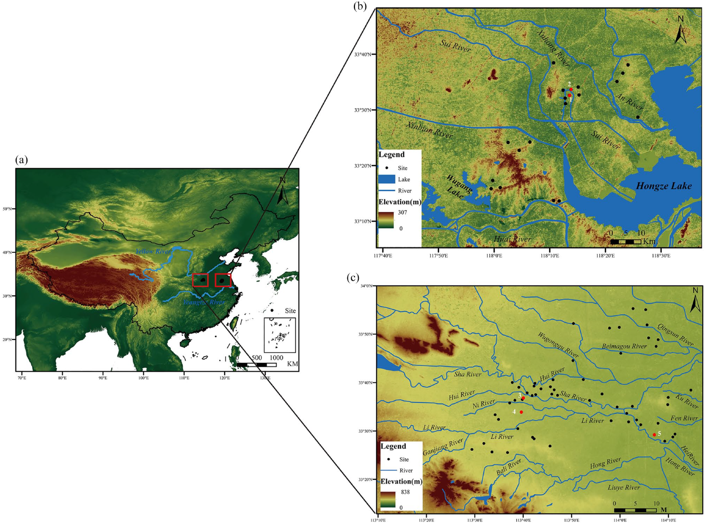
Geographic environment of the studied region and sites. (a) Geographic locations of the two studied regions. (b) Neolithic sites and modern waters in Sihong County, Jiangsu Province. (c) Luohe and surrounding regions, Henan. 1: Shunshanji; 2: Hanjing; 3: Jiahu; 4: Zhangwangzhuang; 5: Xielaozhuang. For the names of other sites marked on the maps, see Table S1 in the Supplemental Information File, available online.
The Hanjing site is located further downstream of the Huai River valley in present Sihong County of Jiangsu Province (Figure 1). The land in the county is dominated by alluvial plains (13–17 m above sea-level), which are surrounded by dense waterbodies (accounting for 40% of its territory), with scattered hills and tablelands. The frequent avulsions of the Yellow River significantly altered the county’s water network in historical times. Many rivers and lakes disappeared during such processes. Some of the river running across the county are man-made canals and channels. Hanjing, alongside the Shunshanji site, are type sites of the Shunshanji culture that has been brought to light in recent excavations with highly developed craft production and burgeoning rice farming economies (Institute of Archaeology of Nanjing Museum and Sihong County Museum, 2014).
Methods and materials
Excavations and environmental sampling at the Xielaozhuang, Zhangwangzhuang and Hanjing sites
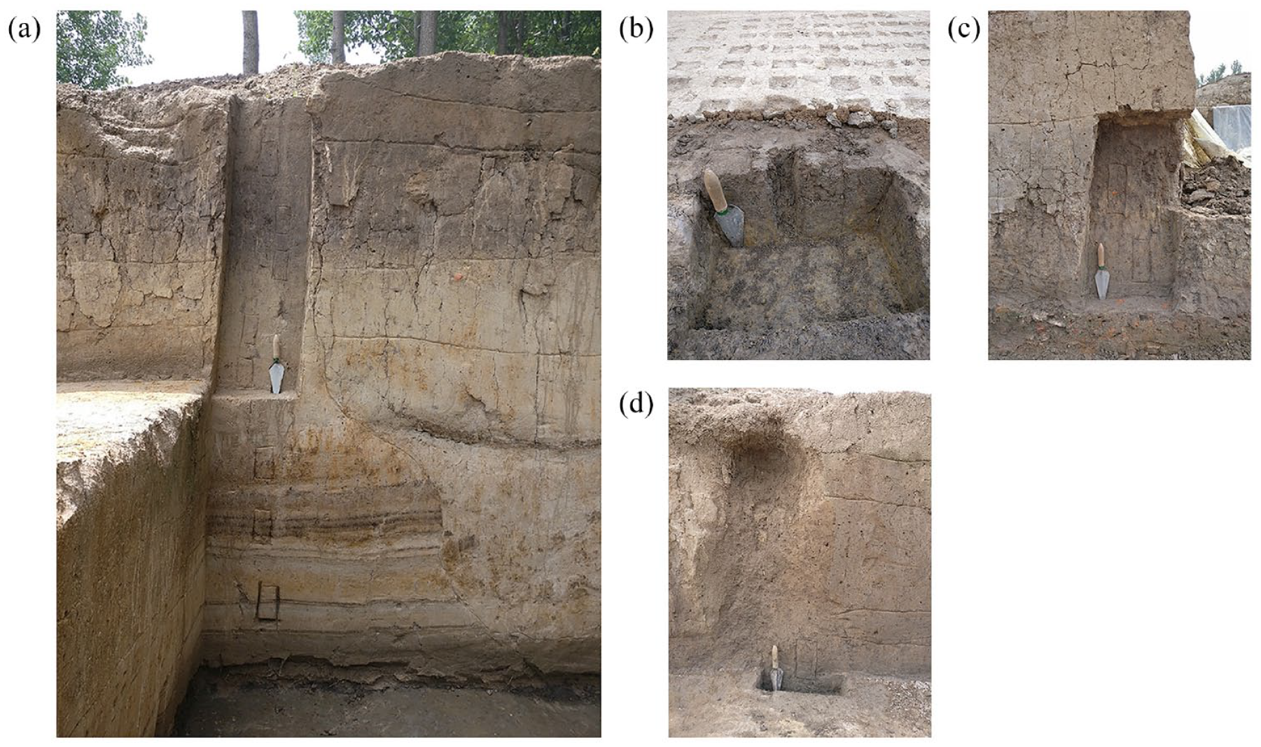
The Xielaozhuang and Zhangwangzhuang sites are both situated on the present-day flood-buffering zone of the Yellow River (Figures 2 and 3). The average altitude on the flat terrains is 60–70 m above sea-level, with only 1–2 m of relative height to the surrounding ground. The Xielaozhuang site (58 m above the sea-level) measures ca. 11 ha, but because of its low-lying position and intensive quarrying activities, 90% of the site area has been severely damaged. The excavation from 2017 to 2018 unearthed an area of 1343 m2, revealing 6 house foundations, 93 graves and a large number of ash pits and wells (Figure 2). The excavated area displays signs of functional division, including residential areas in the northern and middle parts and separate cemetery areas in the middle and eastern parts. The graves in the middle cemetery align in five rows from east to west, which dated to multiple cultural phases (Figure 2). Scattered between these graves are several pits containing ceramic figurines and other artefacts likely related to sacrificial offerings.
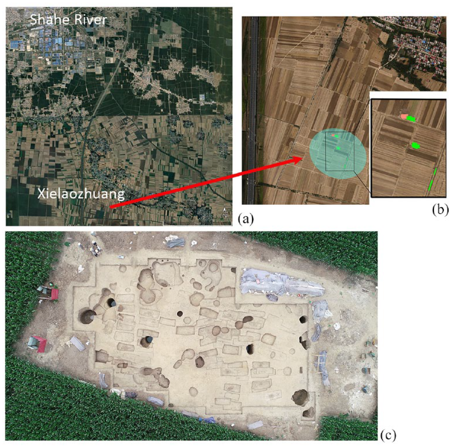
Geographic environment and plan of the Xielaozhuang site. (a) Predominant low-lying land surrounding the Xielaozhuang site in Xiping County, Zhumadian City. (b) Rough plan of the site according to excavation and drilling survey. The circle roughly denotes the core distribution area of the site. Pink square refers to the excavation in 2017 and green squares refer to the excavation in 2018. (c) Aerial photo of the excavation of the cemetery, note that most of the grave pits are shallow as the upper parts of them have been destroyed.
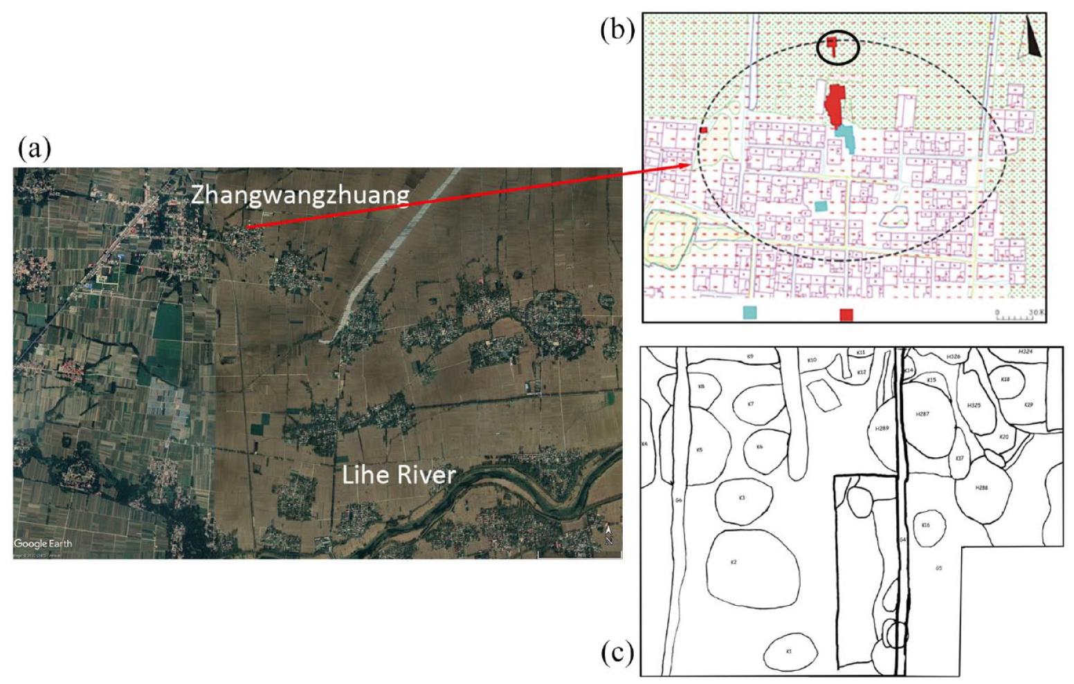
Geographic environment and plan of the Zhangwangzhuang site. (a) Predominant low-lying environment surrounding the Zhangwangzhuang site in Wuyang County, Luohe City, with the Lihe River running south of the site. (b) Plan of the Zhangwangzhuang site. Black dot line roughly sketches out the distribution area of the site, black solid line roughly refers to the area where the rice-field-like structures are located, blue rectangulars are the 2015 excavation areas and red rectangulars show the 2016 excavation areas. (c) Distribution of rice-field-like structures and other archaeological features (see Supplemental Table S3 for details, available online). (b) and (c) modified after Huan et al. (2022) with permission.
Situated 50 km west of Xielaozhuang, the Zhangwangzhuang site (68 m above the sea-level) is ca. 5 ha in size (note the southern part of it is mostly covered by modern houses). A total of 3650 m2 in the northern part was excavated between 2015 and 2017. Sixty four houses, almost 600 ash pits and 3 graves, alongside abundant pottery, stone and bone artefacts and organic remains were unearthed. There might be some spatial differentiation within the residential area. The houses, including both semi-subterranean and above-ground ones, are concentrated in the south-middle part of the excavated area, whilst ash pits are abundantly found in areas close to the ancient river channel. Storage pits are mainly distributed in the northeast and northwest corners, although some of them are also found around some houses (Figure 3). Stylistic changes of pottery sherds unearthed from these houses indicate they were built and used in four cultural phases, but the size of the houses remained small (<25 m2) and their functions likely stayed unchanged.
The Hanjing site is close to the aforementioned Shunshanji site (Figure 4). The site measures roughly 5 ha, ca. 10 m above the sea-level. The excavation from 2014 to 2016 revealed an area of 1150 m2, including parts of the moat, several house foundations, postholes, ditches, ash pits and burials enclosed by the moat (Figure 4), alongside abundant artefacts and organic remains such as animal bones and plant remains.
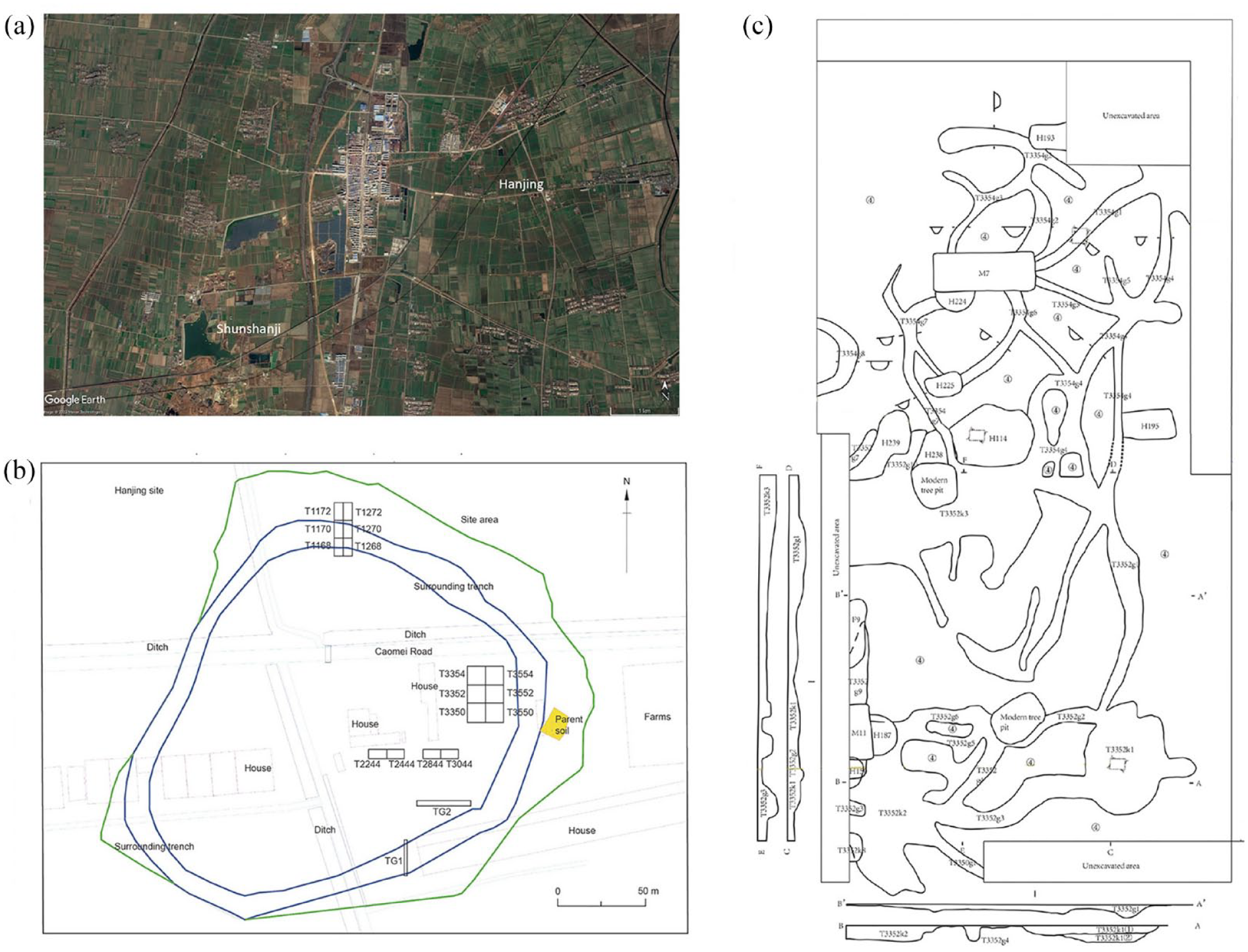
Geographic location and plan of the Hanjing site. (a) Locations of the Hanjing and Shunshanji sites in Sihong County. (b) Plan of the Hanjing site, including excavation areas (the numbered squares), the moat and other features. Blue lines refer to the distribution of the moat and green line shows the area of the site. (c) Detailed plan of the excavated rice-field-like structures and drainage facilities (reproduced from Qiu et al., 2022 with permission).
Amongst the important discoveries at these sites are a range of distinctive archaeological features that might be related to early water management and farming practices. These features include notably the earliest wells at Xielaozhuang and the structures at Hanjing and Zhangwangzhuang that resemble the shape of early cultivated fields found in other prehistoric areas of China. Examination of macro- and micro-fossil plant remains from these features has provided evidence of early rice cultivation and domestication, which is further discussed below (Huan et al., 2022; Qiu et al., 2022).
A number of organic remains and charcoal were collected from different archaeological contexts at these sites for 14C dating (Table 1). Sediments from the rice-field-like features and other excavation features, such as the wells and ash pits, were sampled for phytolith and sedimentological analyses. Sediments from the bottom of well no. 29 were collected for particle size analysis at the depth of 3.5 m from the mouth of the well (which is 3.6 m deep), that is, ca. 4.35 m from the surface ground. Additionally, sediment blocks were collected from the rice-field-like features, ash pits and other contexts for micromorphological studies. These data furnish direct evidence to reconstruct sedimentation processes and land use at these locations (Goldberg et al., 2022). The sample processing methods are described in the Appendix (Supplemental Materials, available online).
List of environmental samples collected from the Xielaozhuang, Zhangwangzhuang and Hanjing sites.

Geoarchaeological surveys at and surrounding the sites
Geoarchaeological surveys were conducted at and surrounding the sites in Wuyang County in Luohe City and Xiping County in Zhumadian City of Henan and Sihong County of Jiangsu, respectively, to reconstruct geomorphological environments and hydrological conditions surrounding the sites. It remains challenging to ascertain exactly on what types of riverine terrains, alluvial fans, low-rising loess hills or plains, were these sites situated. Unlike the typical loess regions in northern China where erosion and quarrying activities often expose deep sedimentary sequences that are convenient for field observation and sampling, it was hard to find exposed sections in these two sub-regions, with very few exceptions. Therefore, we focused on excavation trenches where not only archaeological stratigraphies but also natural sedimentary sequences were unearthed, allowing us to have a preliminary assessment of Holocene sedimentation history.
At Zhangwangzhuang, two excavation trenches were arranged in the northern and northeastern parts of the site. These 2–3 m deep trenches revealed buried ancient channels and long alluvial history. The sedimentary sequence from the channel was carefully recorded (Supplemental Table S1, available online), from which 14C dating and sediment samples were collected. Whilst no such trenches were at Xielaozhuang, this lack of systematic palaeo-environmental information can be compensated by that from Zhangwangzhuang, given that they are located not far from each other and thus have similar environmental contexts. Around Hanjing and Shunshanji in Sihong County, thanks to large-scale quarrying, long late-Pleistocene and early-Holocene sediment sequences were exposed. Although these sequences were not directly dated, the relative stratigraphic order (i.e. the layer containing Shunshanji-culture-styled pottery is found sandwiched between the underlying loess-like sediments and the overlying alluvial deposits) provides a reliable relative chronology for our preliminary reconstruction of the local environment.
Results
Chronology of the early-to-middle Holocene occupation at the sites
Results of 14C dating from the three sites are presented in Table 2. Although the grape seed and fruit stone from Xielaozhuang date to as early as ca. 8500–8000 cal. BP, the other 14C dates of archaeological samples from Zhangwangzhuang are concentrated between 6300 and 5600 cal. BP. It can be inferred that these remains represent two episodes of early-to-middle Holocene occupation at the sites, each episode lasting for 700–500 years, with a long hiatus of over 1000 years. It should be noted that the preservation of bones at Xielaozhuang and Zhangwangzhuang is poor, and some of the 14C dates (especially of charcoal) should be treated with caution. The 14C dates of rice grains and charcoal from Hanjing fall between 8400 and 7700 cal. BP, including three designated cultural phases (I, II and III), roughly contemporary with those of the Shunshanji site (Institute of Archaeology of Nanjing Museum and Sihong County Museum, 2014; National Museum of China, Nanjing Museum, & Sihong Museum, 2018a, 2018b).
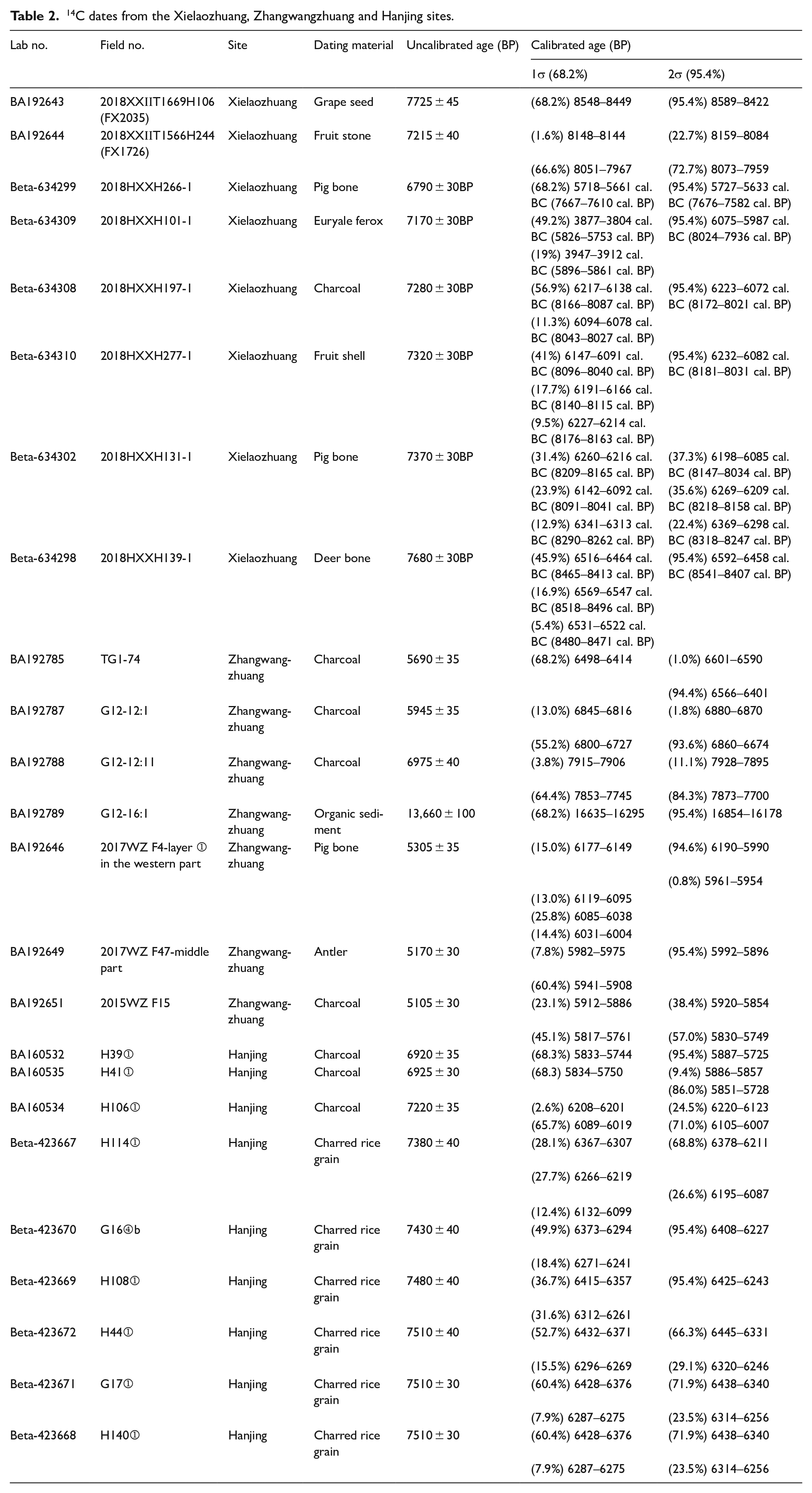
14C dates from the Xielaozhuang, Zhangwangzhuang and Hanjing sites.
Palaeo-environments at and surrounding the studied sites
Xielaozhuang and Zhangwangzhuang
At Zhangwangzhuang, excavation trench no. T1037 shows that prior to the onset of Yangshao occupation, the area received continuous sedimentation, which was, however, punctuated by seasonal drying events when hard iron-pans were formed (Figures 5 and 6) (French, 2022: 85). The size and sorting of the sediments fluctuate from the bottom to the top of the profile (Table 3), which is typical in alluvial settings. Also typical are abundant iron-Mn nodules and coatings, as well as fine sediment laminae, which resulted from oscillating hydrological and sedimentation regimes (Figure 6). Notably, the thin section slides do not show strong signs of soil formation when the landscape was first disturbed by pit-digging and other human activities, suggesting that the inhabitation began when the surface was still unstable. The surface disturbance is further confirmed by the presence of many dusty clay coatings, some of which have a layered structure and contain fine organic pigments often derived from intensifying land-use in local areas (Figure 6).
Excavated profiles at Zhangwangzhuang where thin section samples were collected. (a) Trench no. T1037, the lower part are alluvial sediments with iron-pan and fine sediment laminae, whilst the upper part contains ash pit sediments and well-developed soil. (b) Rice-field-like structure no. H287 from trench no. T3453. (c) Ditch sediments from trench no. T3452. (d) Rice-field-like structure no. H326 from trench no. T3453.
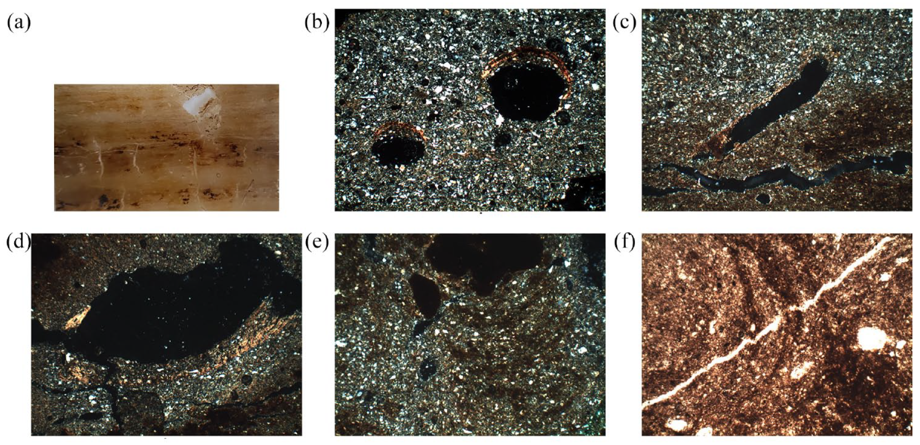
Photomicrographs from the Zhangwangzhuang site. (a) Details of the iron pans of the excavation profile in trench no. T1037-8. (b) Limpid clay coatings in a groundmass with abundant cross beddings (no. T1037-8), XPL. (c) Dusty to limpid clay coatings near an iron pan and sediment beddings dominated by coarse-sized minerals (no. T1037-8), XPL. (d) Limpid clay coatings and clay-depleted zones with a concentric structure (no. T1037-7), XPL. (e) Iron coatings with concentric features (no. T3453-H287-upper unit), XPL. (f) Iron coatings with concentric features (no. T3453-H287-lower unit), PPL. Frame width: (a) 5 cm and (b–f): 2.8 mm.
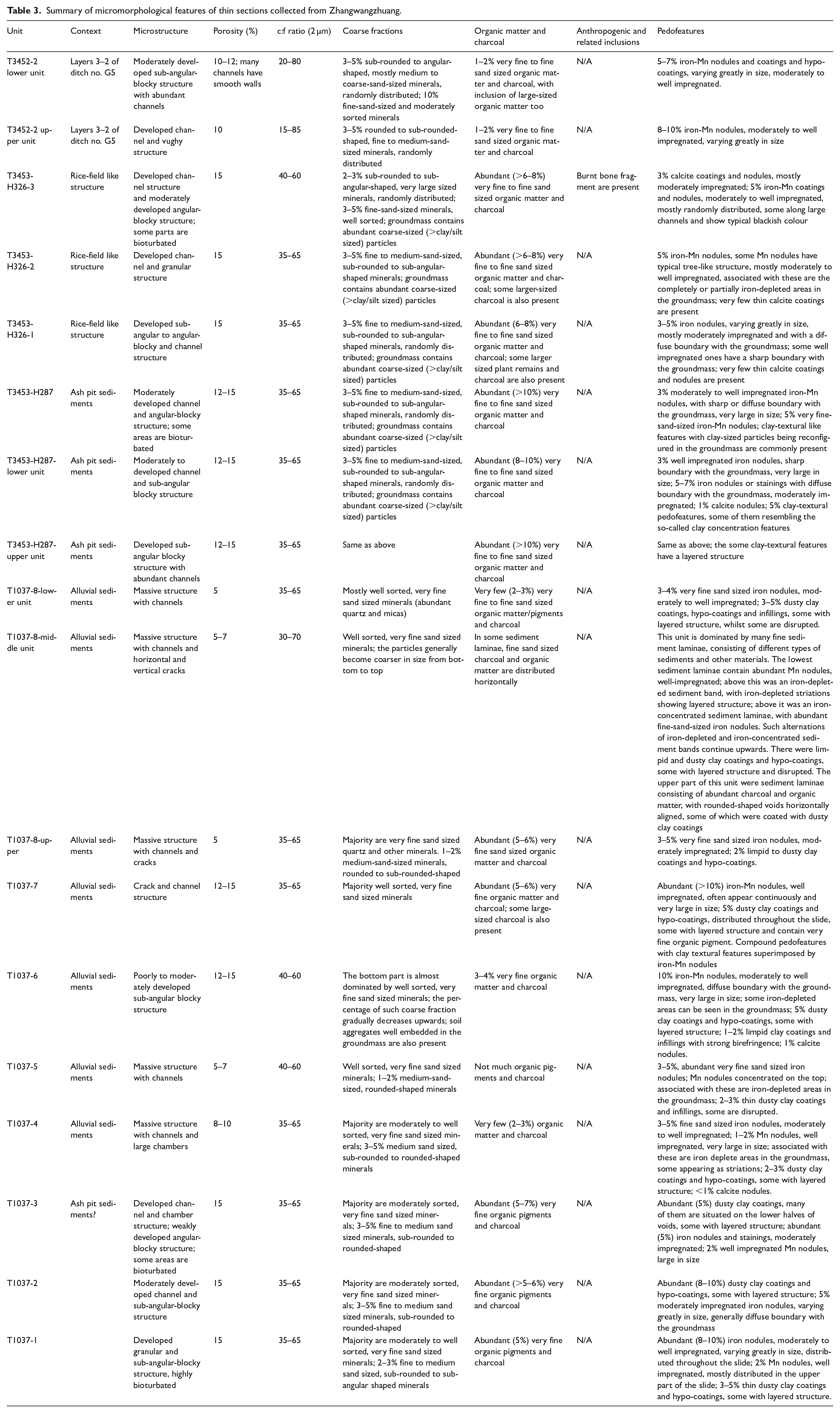
Summary of micromorphological features of thin sections collected from Zhangwangzhuang.
Excavation of the ancient river near Zhangwangzhuang reveals that sediments in the lower and middle parts (ca. 7800–6800 BP, see Table 3) of the river were dominated by light greyish to brownish silt with embedded fine laminae and sandy lenses (Supplemental Table S1 and Figure S1, available online), indicating volatile hydrological regimes with generally strong hydrodynamics that brought in coarse-sized sediments. These were interrupted by waterlogging events which caused the greyish colour. Coinciding with the onset of Yangshao occupation at Zhangwangzhuang was the deposition of finer-sized silty clay or clayey sediments in the upper part of the river under more stabilizing hydrodynamic conditions. This gradually gave way to a sedimentation regime dominated by greyish silty clay with the formation of abundant iron nodules along plant roots.
To sum up, the sedimentation and hydrological environment during the early-to-middle Holocene at Zhangwangzhuang (very likely at Xielaozhuang too given their close vicinity) was volatile, in agreement with published studies as briefly reviewed before. It was only after 7000–6800 BP that it started to stabilize gradually. Whilst the Neolithic occupation began as early as 8500 BP in the region, this environmental volatility remained a challenge even during the early Yangshao period and required innovative responses to many issues caused by it, including water management.
Hanjing
Around the Hanjing site in Sihong County, which is not far from the well-known Shunshanji site, there are extensive late-Pleistocene loess or loess-like sediments, that were primarily deposited during the Last Glacial Maximum. As part of the so-called Xiashu Loess (L1), which is of a finer size than typical loess (Han et al., 2019; Jiang et al., 2020; Li et al., 2001), the loess mantled on the palaeo-surface and created wide and flat land, which was subject to surface geomorphological processes that further transformed the environment. The so-called reworked loess is commonly present in Holocene sedimentation sequences in Jiangsu (e.g. Mao et al., 2006). As shown in Supplemental Figure S2, available online, the environment surrounding Hanjing (20 m above the sea-level) is characterized by low-lying terrains, with parts of the land surrounding now being used as a reservoir. The sedimentation was dominated by alluvial aggradation as evidenced by the many horizontal beddings in the profile, of which the greyish sediment bands represent multiple local waterlogging events (Supplemental Figure S3, available online). Similar to that in Luohe, the landscape surrounding Hanjing remained unstable prior to and during the occupation at the sites.
On a broader scale, whilst regional climate records suggest that the occupation at Hanjing might have coincided with a relatively cold and dry period (Hu et al., 2018; also see our review above), the geomorphological and hydrological environment remain challenging. Our results of the immediate environments surrounding these three studied sites provide direct contexts to understand functions of the water management structures at the sites, which is supplemented by our detailed sedimentological results below.
Wells, rice-field-like structures and their functions
The four excavated wells at Xielaozhuang were located in the northeastern part of the site (Figure 2). They are typically rounded in shape with smooth vertical walls, measuring ca. 1.2 m in diameter at the upper mouth and ca. 3.5 m in depth. Intact pottery vessels with two handles on the shoulder were often found at the bottom of the wells, which could be tied with threads and used as vessels to draw water from the wells (Figure 7). Sediments collected from the bottom of one of the wells (H39) display distribution curves almost identical to those of typical wind-blown loess in the nearby region (e.g. Cao et al., 2018), with slightly wider peaks on the silt-sized fractions (Figure 8), which might indicate a poorer sorting of the water-borne sediments in the well. In particular, those from the bottom of the well show a narrower peak, indicative of a better sorting, than those from the upper part of the well sediments. The lack of coarse-sized sediments further suggests a gentle hydrodynamic regime during the use or immediately after the abandonment of the well. Therefore, some intentional upkeep of the wells which changed the water regime cannot be ruled out.
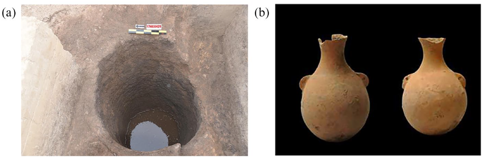
Water well and pottery container found at Xielaozhuang. (a) Excavation photo of the water well no. H29 at Xielaozhuang. (b) Pottery vessels excavated from the water well, note most of them were covered in limescale after being submerged long in the water.
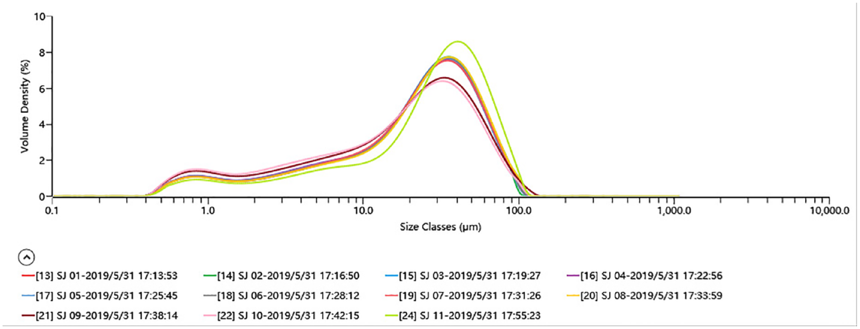
Particle size distribution curves of sediment samples from well no. H29 (SJ01-SJ11, top to bottom).
More than 20 rice-field-like structures have been found concentrated in the northwestern part of Zhangwangzhuang, close to the aforementioned river (Figures 3 and 5). Most of these features are circular in shape and range in size from only 1 to 4 m2 and 20 to 50 cm in depth (Supplemental Table S2, available online). The brownish clayey sediments in these features contain very few pottery sherds, burnt clay particles or other anthropogenic inclusions. The main micromorphological features of the sediments are redoximorphic features, such as iron-Mn nodules and coatings along decayed plant roots or other voids, and clay textural features, such as dusty clay coatings with layered structure or the so-called silty or dusty clay concentration features. There are also abundant charcoal and organic matter (Table 4). The iron-Mn nodules are surrounded by iron-depleted areas in the groundmass (Figure 6). Calcitic coatings and nodules are common. The implications of these micromorphological features to understand hydrological conditions in these rice-field-like structures are discussed below. These features are different from those found in other contexts such as ditch no. G5 (Table 4), which are dominated by more angular-shaped and poorly sorted coarse-sized sediments, characteristic of typical colluvial process that leads to a rapid sedimentation in the ditch. However, there are also abundant iron-Mn nodules and coatings in the ditch.
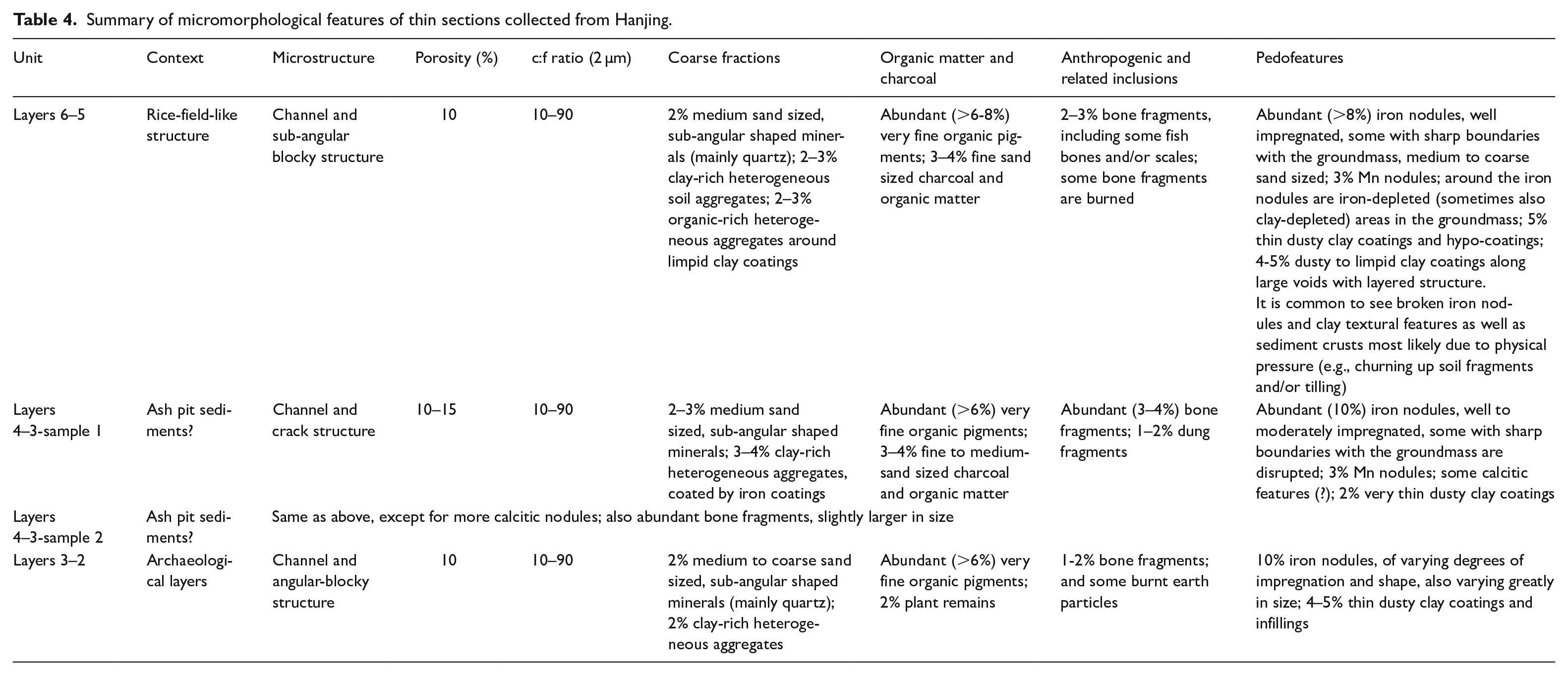
Summary of micromorphological features of thin sections collected from Hanjing.
The moat at Hanjing is of an irregular rounded shape, about 10 m in width and 1 m in depth. It extends to the low-lying terrain in the east and southeast, where three rice-field-like structures were excavated, surrounded by 18 small-to-medium ditches (Supplemental Table S2, available online). The darkish clayey sediments in these features contain abundant charcoal and burnt-earth particles, different from those at Zhangwangzhuang. Typical micromorphological features of the ‘field’ sediments include a moderately to highly mixed groundmass containing many clay-rich and organic-rich heterogeneous aggregates and broken pedofeatures, abundant iron-Mn nodules and coatings occurring near iron-depleted areas in the groundmass, and many dusty clay coatings often with layered structure (Figure 9). The disrupted iron nodules, clay coatings, and sediment crusts are particularly characteristic. These samples are also rich in organic matter and charcoal, including fine organic matter/charcoal pigments, and some bone fragments (Figure 9). The above features contrast with those found in other archaeological contexts, which contain much fewer iron-Mn nodules and very few broken pedofeatures caused by physical pressure (Table 4).
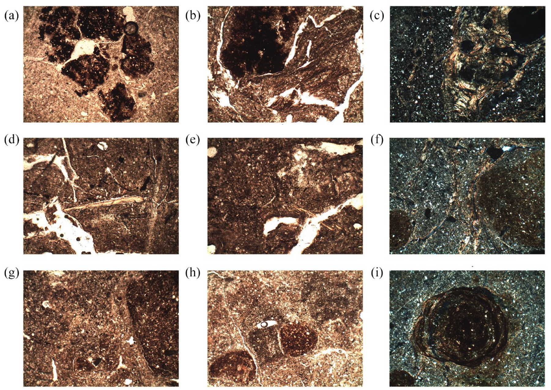
Photomicrographs from the Hanjing site. (a) Disrupted Mn nodules, PPL. (b) Dusty clay intercalations with layered structure and iron-Mn nodules, PPL. (c) Heterogeneous aggregate containing abundant disrupted bright limpid laminated clay textural features, XPL. (d) Fish scale, PPL. (e) Hanjing 6–5 thin dusty clay coating in organic-rich groundmass, also note thin bone fragments on the left 5× PPL. (f) Laminated dusty-limpid clay coatings next to large rounded-shaped iron nodules, some of the clay coating the nodules, XPL. (g) Organic-rich aggregate and clay-rich aggregate separated by groundmass material in the middle, PPL. (h) Organic-rich aggregates and iron nodules, PPL. (i) Iron nodules superimposing on clay textural feature, XPL. All from Hanjing layers 6–5, frame width 2.8 mm.
To summarize, the rice-field-like structures at Zhangwangzhuang and Hanjing share some similarities in macro- and micro-morphologies. First, these ‘fields’ were all situated in or near low-lying areas at the sites. An Agisoft Photoscan simulation at Hanjing demonstrates that the topography in trench no. T3352, where the ‘fields’ were found, leaned from the southeast to southwest and northwest corners (Supplemental Figure S1, available online), indicating that water flowed into these ‘fields’. Second, some initial forms of irrigation and drainage facilities occurred, such as the ditch (no. G16) at Hanjing that was close to the ‘fields’, which might have facilitated irrigation and drainage, and several other structures at Zhangwangzhuang, although their functions are to be further ascertained. Third, as described above, there are abundant redoximorphic and clay textural features that resulted from frequent wet-dry alternations in the ‘fields’, which are considered typical of cultivated soils with irrigation (Deák et al., 2017; Lee et al., 2014; Pang et al., 2007). Four, these soils/sediments generally contain abundant charcoal and organic matter, some of which are fine-sized pigments, possibly due to frequent breaking up of soil aggregates and charcoal through repeated farming. These common macro-and-micromorphological features provide useful references for further understanding the interactions between early rice farming practices and the environment in the UMHR region.
Discussion
Water management and early rice-farming systems in the prehistoric Huai River region
Redoximorphic features are formed as a result of frequent reduction and oxidation processes that occur within and between soil horizons, especially along plant roots and voids where air is trapped or released repeatedly due to irrigation, drainage practices, or similar activities (Lindbo et al., 2018; Vepraskas and Craft, 2016). Some characteristic redoximorphic features might further indicate different hydrological regimes in the soil. For instance, the well impregnated and relatively large-sized iron-Mn nodules and coatings (Figure 7 and Tables 3 and 4), and the iron-depleted areas surrounding them in the groundmass can be related to longer episodes of waterlogging (Lindbo et al., 2018). On the other hand, the formation of clay textural features involves more complicated processes that take place either within or between different soil horizons. Flooding and subsequent draining often causes translocation of clay-sized particles. This phenomenon is particularly evident in cultivated soils that experience frequent physical disturbance (e.g. tilling and ploughing) and irrigation-drainage cycles, which cause readily movable silt, clay and fine organic pigments and charcoal to mobilize and precipitate in different parts of the soil profile (Kühn et al., 2018; Li et al., 1996; Macphail and Goldberg, 2018). In paddy soils, reduction accelerates the breaking up of clay particles and thus promotes formation of clay textural features (Lindbo et al., 2018). In combination with the presence of calcite features which form under drying conditions, it is clear that these ‘fields’ were obviously not in a permanently waterlogging condition but experienced frequent wetting-and-drying cycles due to possibly intentional water management on these low-lying areas of the sites which were regularly inundated.
In their study of phytolith remains from these ‘fields’ at Hanjing, Qiu et al. (2022) found that the Oryza-type bulliform cells at Hanjing are smaller in size than those at Shunshanji, and that the Oryza-type bulliform cells and double-peaked Oryza-type glume cells hold differential predictions of rice domestication. They suggest that this discrepancy might be due to the early stage of rice cultivation and domestication at Hanjing. The domestication of rice is confirmed by the presence of domesticated type spikelet bases. Additionally, Luo et al. (2021) suggest that, according to the ratio of sensitive to fixed phytolith types (also cf. Weisskopf et al., 2015) the early-stage rice cultivation at Hanjing was dominated by ‘lowland rain-fed rice fields’ drier than wild rice habitats, and that the condition in these ‘fields’ became wetter gradually, necessitating the ‘manipulation’ of the cycle of flooding and drainage for rice growth. Huan et al. (2022)’s recent study of phytolith remains from Zhangwangzhuang provides further evidence of early rice farming practices. They applied discriminant functions to analyse phytolith assemblages from both the ‘fields’ and other archaeological contexts and identified different habitats where wild rice, domesticated rice and other non-rice plants grow. Referencing to phytolith distributions in modern rice paddy fields, they suggest that 17 samples from the ‘fields’ belonged to the ‘domesticated’ group. Using the discriminant function, they further identified three aggregation clusters where rice bulliform phytoliths were concentrated, close to or higher than the standard (5000 grains per 1 g dried sediment) proposed by Japanese scholars to identify rice paddy fields. Their results accord with the excavation and our geoarchaeological results described above.
Our geoarchaeological and archaeobotanical evidence and the excavation results suggest that rice fields or modified habitat for the growth of rice plants were already constructed and used at both Hanjing and Zhangwangzhuang. These fields are generally small, without typical field structures such as bunds, but some are connected with ditches and/or moats. Benefitting from a favourable climate between 8500 and 6000 BP, the prehistoric communities in the UMHR region started to experiment with rice farming. Despite a noticeable gap in the regional inhabitation history (which might be related to taphonomy and other issues), the rice farming in the region saw pronounced developments during the early-to-middle Holocene, with not only the consistent presence of domesticated rice but also increasingly sophisticated water management. The construction of these fields indicates that the farmers already actively engaged in landscape modification for farming. These fields can be considered formal evidence of an integrated rice-farming system in prehistoric UMHR.
Additionally, as the UMHR region especially the upper Huai River saw the development of mixed farming of rice and millet in later Neolithic period (cf. Yang et al., 2016), managing water for more diverse purposes would have become even more critical to the development and succession of prehistoric cultures.
Wells, fields and emergence of early-Neolithic villages in the Huai River region
The beginning of farming and sedentary life in prehistoric China was famously associated with the Yellow River valleys in 1970s, and recently with China’s own ‘fertile crescent’ (Ho, 2017; Liu et al., 2009). However, alternative frameworks to understand the environment and origins of agriculture can be found at Neolithic sites with evidence of early rice cultivation in the Yangtze River valleys and intermediate geographic zones such as the UMHR region, including the Jiahu site. As shown in in Figure 1, except for a few sites that were located on the slopes of low hills and tablelands, most Neolithic sites in the UMHR region, regardless their cultural phases, are situated on low-lying plains, very often surrounded by lakes and wetlands (also see Zhang et al., 2023). This geomorphological location in the UMHR region where early farming villages occurred represented a cognitive choice by early rice farmers to venture into the low-lying plains with rich natural resources. The challenging geomorphological environment served as an impetus for initial hydraulic innovations. Apart from houses and associated facilities such as storage pits, these newly emerged early-to-middle Holocene villages also had some of the earliest wells and fields in prehistoric China. The construction and operation of these water management and food production infrastructures would have in turn had profound impact on the structures of the early villages. First, although relatively small in scale compared to later-period moats and water management infrastructures, these moats and wells required collaboration beyond individual households and groups to build, which would have initiated and fostered the cooperations and interactions between these groups (also see Fuller and Qin, 2009 for a discussion on water management and labour organization at some prehistoric Middle Yangtze River sites such as Chengtoushan). Second, the appearance of the fields stimulated the functional division in these villages as food production and processing were becoming essential parts of the settlements. According to Luo et al. (2021), some areas at Hanjing were closely associated with rice processing based on phytolith evidence. A similar spatial pattern is also suggested by Huan et al.’s (2022) aforementioned study at Zhangwangzhuang.
In summary, from Jiahu, which was also situated on natural levees on alluvial lowlands (Henan Provincial Institute of Cultural Relics and Archaeology, 1999), to Shunshanji, Hanjing, Xielaozhuang and Zhangwangzhuang, there seemed to be a consistent focus on lowland environments for settlement location and economic production. These rich and diverse lowland habitats provided sufficient water and other resources for early rice farming and plenty of opportunities for flourishing hunting and gathering economies. The selection of particular geomorphological environments, the construction of water management facilities and farming fields, and the adaptation to and transformation of these low-lying plains in prehistoric UMHR had significant social ramifications. Through these actions considerable labour investment was spent, different social groups were drawn closer, and the basic but fundamental economic and social structure of the early villages was created. Such a cooperative network of rice farming, water management and landscape modification ushered in an unprecedented trend of village construction in the region. Some of the sites such as Jiahu (5.5 ha) and Shunshanji (17.5 ha) already reached a substantial scale, and whilst hunting and gathering remained vital in subsistence economies, rice was becoming an important supplement to the hunted and gathered foods. The appearance of storage pits at many sites, for instance, indicates food surplus. A growing population could be fed by more reliable food production and thus would have become more willing and able to invest in building water management and rice-production infrastructures. Although it is uncertain how the fields were associated with the households at both Hanjing and Zhangwangzhuang, and the full scale of the rice fields at the sites is hard to evaluate, the fields and associated water management structures themselves and their spatial arrangements in these villages indicate a different mode of food production from early millet farming. The difference perhaps lies in labour organization, spatial arrangement, and the farming regime that underlined it, which are to be demonstrated in future studies.
Conclusions
Our understanding of the UMHR region as an important centre for prehistoric rice farming has been greatly enhanced by macro- and micro-scale evidence from excavations and environmental archaeological studies at Xielaozhuang, Zhangwangzhuang and Hanjing. In particular, geoarchaeological evidence from particle size analysis and micromorphology, in combination with published phytolith and macro-plant evidence from the field structures as well as other archaeological contexts at these sites, has proven to be useful in identifying some of the characteristic features resulting from deliberate water management and incipient soil amendment in early rice farming. Despite a pronounced gap in regional occupation, these early-to-middle Holocene villages successfully adapted to the low-lying environment with fluctuating hydrological regimes and began to alter and optimize the environment for water management and rice farming. Although far from being a systematic and full-scale alteration of the environment, such landscape modification was a crucial step towards the construction of classical farming villages. Water management, along with storage and other economic activities and landscaping techniques, enhanced group cooperation for sedentary life. It would have also facilitated the spread of many such villages across the region with similar environmental opportunities and challenges, although more systematic investigations are required to fully understand such processes. Our study contributes to the debate on the ‘Neolithization of water’ (Gebel, 2004) in the transition to sedentary agricultural life and sheds new light on the fundamental differences between early millet and rice farming and their ramifications to the shaping of different Neolithic villages and landscapes in prehistoric UMHR region and beyond.
Supplemental Material
sj-docx-1-hol-10.1177_09596836231197736 – Supplemental material for Wells, fields and the emergence of early-to-middle Holocene villages in the Huai River region, China: Contesting regional similarities and differences on prehistoric water management with new archaeological and palaeo-environmental evidence
Supplemental material, sj-docx-1-hol-10.1177_09596836231197736 for Wells, fields and the emergence of early-to-middle Holocene villages in the Huai River region, China: Contesting regional similarities and differences on prehistoric water management with new archaeological and palaeo-environmental evidence by Yijie Zhuang, Xingtao Wei, Lina Zhuang, Xiaohu Zhang and Junjie Xu in The Holocene
Footnotes
Funding
The author(s) disclosed receipt of the following financial support for the research, authorship, and/or publication of this article: Yijie Zhuang wishes to thank the British Academy through a mid-career fellowship (MCFSS\220025) for their financial support on the collection of some data used in this article. Lina Zhuang would like to thank a National Key R&D Program of China (2022YFF0903500) for their generous support on a project entitled The origins, formation and development of dryland farming in Northern China.
Supplemental material
Supplemental material for this article is available online.
References
Supplementary Material
Please find the following supplemental material available below.
For Open Access articles published under a Creative Commons License, all supplemental material carries the same license as the article it is associated with.
For non-Open Access articles published, all supplemental material carries a non-exclusive license, and permission requests for re-use of supplemental material or any part of supplemental material shall be sent directly to the copyright owner as specified in the copyright notice associated with the article.