
Abstract
Remote-sensing analysis of open-source satellite imagery has identified a major, new distribution of undocumented hunting kite structures in northern Arabia. This new data has important implications on the environmental viability of hunting and on possible settlement patterns during the early and middle Holocene. Running across the eastern side of the Nafud Desert in Saudi Arabia, this research has identified star-shaped kites in a distribution that continues on to southern Iraq. From a broader perspective, this new distribution appears to represent a continuation of the well-known arc of kites recorded running principally through southern Syria and eastern Jordan. As well as representing an important archaeological identification in its own right, this new distribution also has important implications in terms of the paleoenvironment of the region, faunal dispersals and human cultural connections.
Keywords
Introduction
The past decade has seen a significant growth of archaeological research on kite structures, large stone-built features that are widely accepted to have functioned as a type of hunting trap (e.g. Bar-Oz et al., 2011; Crassard et al., 2015, 2022; Helms and Betts, 1987; Zeder et al., 2013). The defining physical characteristics of kites are a combination of three elements: driving walls that stretch over hundreds of metres and even kilometres, providing a guided approach to an enclosure of varying shape (the ‘head’), and cells that are often integrated into the walls of the enclosure and were in some cases used as trapping pits (Crassard et al., 2022). To date, over 6000 desert kites have been reported, and by far the majority have been documented in the Levant and Arabia (Barge et al., 2018, 2022; Groucutt and Carleton, 2021), with an example from south-eastern Jordan producing a construction date of 7800 BCE ± 1000 at (Al Khasawneh et al., 2019), but with later dates from the fifth to the third millennium BCE for kite structures in northern Syrian and the southern Negev (Zeder et al., 2013: and references therein). Several species have been discussed as the possible hunting targets of kites, including ostrich, hartebeest, Arabian Oryx and onager (Zeder et al., 2013), although gazelles appear to be have been the most hunted species, and it has been hypothesized that unsustainable killing via the use of kites may even have led to the local extirpation of gazelle species (Bar-Oz et al., 2011; Zeder et al., 2013) and likely played a major role in the transformation of Holocene ecosystems due to their spatial and temporal spread (Groucutt and Carleton, 2021).
This paper explores a new distribution of kite structures identified through remote-sensing survey by the Endangered Archaeology in the Middle East and North Africa (EAMENA) project at the University of Oxford over northern Arabia. This new dataset transforms our current understanding of these sites, pushing their distribution into eastern Arabia and raising questions about the prehistoric environment and cultural connectivity in the region. This data was collected via a remote-sensing survey of open-source satellite imagery platforms and documents kites across the eastern Nafud Desert in Saudi Arabia and stretching as far as southern Iraq, the first time this site type has been identified in the latter region. Our survey documented over 300 new sites, which are morphologically closely connected with the kite types identified in eastern Jordan (Barge et al., 2015; Kempe and Al-Malabeh, 2013).
Background
Kite structures were first recognized archaeologically in the Middle East, in the 1920s, as British and French pilots became active over the skies of their respective colonial Mandates (Brunner, 2015a: 70; Kirkbride, 1946; Rees, 1929). The term ‘kite’ was first coined by Rees in 1929 (Rees, 1929), although aerial photographs of these structures had already been published in 1927 by Maitland (Maitland, 1927). The term was subsequently extended to ‘desert kite’ by Kirkbride (Kirkbride, 1946) a term that is still used today (e.g. Brunner, 2015a). These large stone structures cannot be easily observed on the ground, and consequently did not receive much attention until observed from the air by colonial air forces of the British and French Mandates. The distribution and form of numerous kites were recorded incidentally as part of a British Royal Air Force mapping mission in early 1931 across the Azraq lava fields (Fradley, 2021; Geographical Section, 1933). Recent discoveries have largely been driven by the advent of commercial satellite imagery and platforms such as Google Earth giving access to that imagery and enabling the identification of new distributions beyond the Levant and northern Arabia (e.g. Kempe and Al-Malabeh, 2013; Kennedy, 2011), replicating technologically the way in which the first distributions were identified from a bird’s eye perspective by aircraft pilots a century ago. However, the limited number of structures investigated in the field means that there is a lack of certainty in our understanding of these sites, including their relative or absolute chronology.
In a recent comprehensive study of kites in the Near East and in Asia, Crassard et al. (2022) provide a detailed analysis of the layout, distribution, topography and likely use of kites. Here, we summarize some of the key characteristics relevant to kites in northern Arabia and contrast these with geographically wider examples of these forms of structure.
Kites are widely accepted to function as a wild game drive or hunting trap (Bar-Oz et al., 2011; Helms and Betts, 1987; Zeder et al., 2013), although alternative interpretations have been offered, including a possible use for managing livestock (Echallier and Braemer, 1995; Eddy and Wendorf, 1999). The broad concept of the hunting thesis is that the guiding walls would lead wild game towards the enclosed kite head where the animals could be trapped and likely slaughtered. Excavations have shown that in many examples the cells in the enclosure walls were constructed as deep pits, in some cases up to several meters deep, which would have allowed hunters to trap the animals. However, pits excavated in kites on the edge of the western Nafud desert were considerably shallower and only reached depths of between 25 and 75 cm, so less convincingly interpreted as trapping pits (Crassard et al., 2022).
Since the first archaeological descriptions of kites in the early 20th century, variations of the kite form have been identified over a wider area, ranging from Yemen (Brunner, 2015b, 2021) through to Turkey and Armenia (Barge et al., 2015, 2021), with distributions of comparable types in southern Africa, Uzbekistan and Khazakhstan (Barge et al., 2016; Lombard et al., 2021), and numerous typological studies have focussed on kites in the Levant (Chambrade and Betts, 2021; Echallier and Braemer, 1995; Helms and Betts, 1987). However, there is little clear agreement between researchers on the terminologies and typologies that are used to define kites and the structural components of the monuments, so it is acknowledged that the descriptor used in this paper represent a broad account of a far more complex kite morphology.
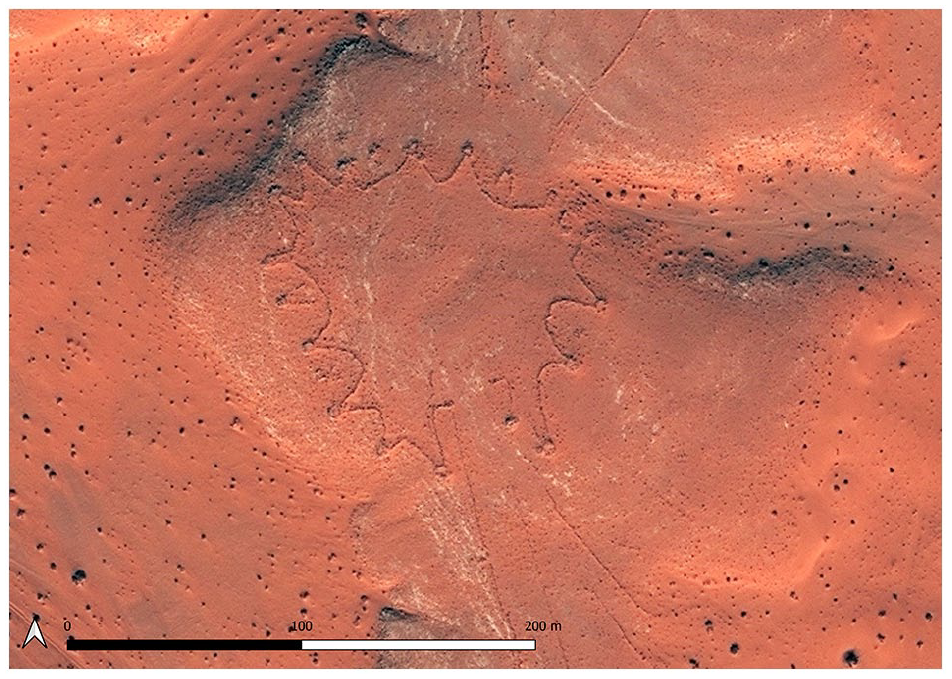
In the eastern Badia of Jordan the main type of kite structure are variations of star shaped kites, which have a large enclosure with irregular protruding points, often with dug out pits (Figure 1) (Abu-Azizeh et al., 2021; Kennedy et al., 2015). Arrow shaped kites are also common and include a number of variations (Kennedy et al., 2015: Fig 15), while complex barbed kites were recorded in the Harrat Khaybar in central-western Saudi Arabia (Groucutt and Carleton, 2021). These are quite distinct from typical kites reported in the Negev and Sinai, which are much simpler V-shaped constructions leading into a single cell or pit-trap, now found to extend down the western side of Saudi Arabia (Nadel et al., 2021). Similarly, the kites of the Harrat Nawasif in western Saudi Arabia are simpler V-shaped structures, with guiding lines leading to a short row of cellular structures (Groucutt and Carleton, 2021). Kites reported from Yemen have been described as Y-shaped. Rather than ending in a single cell as documented in Sinai, or in a row of cells as documented in Harrat Nawasif, Y-shaped kites lead into a short row of chambers (Brunner, 2021). On a broad scale the morphology of kite structures appears to change from east to west, with western kites in a stretch from Sinai to Yemen predominantly showing very simple, and small enclosures, in Yemen even reduced to small openings, while the kites in the eastern areas – covering northern Arabia, eastern Jordan and southern Syria are typically characterized by large enclosures, with multiple cells (Groucutt and Carleton, 2021; Kennedy et al., 2015).
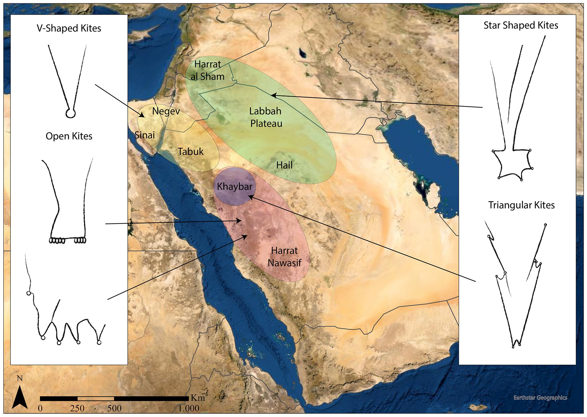
Simplified distribution of different kite types across south-west Asia (based on Groucutt and Carleton, 2021).
Kites are typically built with consideration of features in the local landscape and topography (for a detailed analysis see Crassard et al., 2022). For example, in the eastern Badia of Jordan, guiding walls are often located on plateaus, and frequently integrate water sources, that would have represented an ideal starting point to round up and chase animals towards the kite (Abu-Azizeh and Tarawneh, 2015; Helms and Betts, 1987). Moreover, enclosures that form the ‘heads’ of kites are often found beyond the crest of a slope, or inside naturally enclosed spaces and obscured from view (Abu-Azizeh and Tarawneh, 2015; Crassard et al., 2022), a characteristic that was already evident in earliest descriptions of kite structures (Rees, 1929). While in some regions the orientation of kites face in one direction, other regions appear to show more variability. This has been attributed to the difference between seasonal and daily game movements, perhaps in combination with the dominant wind directions and characteristics of the local topography (Chambrade and Betts, 2021; Helms and Betts, 1987). However, recent analysis by Crassard and colleagues indicates that kites in areas with complex topography tend to have a more varied orientation, interpreted as the result of divergence of animal movements from their general direction to mitigate topographic barriers (Crassard et al., 2022). Similarly, kites documented in the Harrat Nawasif in western Saudi Arabia, followed a pattern where the enclosure is often constructed at the edge of the lavafield, with walls extending into lower lying areas, and the use of slopes and cliffs as part of a natural enclosure. Cliffs were also integrated into the design of kites, possibly to reduce the amount of guiding walls that needed to be built (Groucutt and Carleton, 2021).
During the Holocene Humid Period (HHP) in the Arabian Peninsula (between ca 9000 and 4000 BCE) an increase in rainfall driven by a northeastward shift of the African Summer Monsoon led to a spread of vegetation and grasslands. Lake records in the oasis of Tayma suggest that this period of humid conditions peaked between 6800 and 5900 BCE (e.g. Neugebauer et al., 2022). In the oases of Jubbah and Tayma permanent lakes formed, while short-lived lakes dating to this period have been identified in the interdune lake basins of the Nafud desert and in the Jebel Oraf basin (Breeze et al., 2017; Engel et al., 2012; Guagnin et al., 2020; Hilbert et al., 2014; Wellbrock et al., 2018). The increase in rainfall supported a rich local wildlife, as well as the spread of pastoralism, with wildlife and livestock documented in countless rock art panels (e.g Guagnin et al., 2016). The end of the HHP, after ca 4000 BCE, is associated with widespread depopulation in the region (Petraglia et al., 2020), and a subsequent shift to oasis settlements (e.g. Hausleiter and Eichmann, 2018).
The long use of different kite morphologies, with early dates in eastern Jordan centred on 7000 BCE, where a very short period of use was attested (Abu-Azizeh and Tarawneh, 2022; Abu-Azizeh et al., 2021), and with other structures in the Sinai and southern Syria dated to the third and fourth mill BCE (Zeder et al., 2013) and kites in Harrat Nawasif evidently in use as late as the Iron Age (Groucutt and Carleton, 2021), implies that their use must have spanned considerable changes in subsistence and in the Holocene environment. However, it should be highlighted that these date ranges relate to morphologically and geographically distinct kite forms, and that the evidence from the kites in eastern Jordan – which is most directly relevant to the present paper – so far seems consistently to be situated in the Levantine Neolithic, albeit based on a limited sample size and with a range of kite types and possible phasing identified in this region (Betts and Burke, 2021).
Early kites in the south-eastern Badia have been attributed to a community of specialized hunters (Abu-Azizeh and Tarawneh, 2022), and the adoption of herding appears to have been diverse across the Levant. In the eastern Badia, by the mid-seventh millennium BCE, subsistence was characterized by a mixed economy that combined livestock and hunting (Martin and Edwards, 2013). Stable isotope and dental microwear analysis of Epipalaeolithic and Neolithic gazelle samples from the Badia have been used to suggest encroaching pastoralism may have influenced increasing range mobility in gazelle herds, although migratory distances still appear to have been relatively limited (Henton et al., 2018), while other studies have highlighted the heterogenous adoption and adaptation of pastoralism in this region (Miller et al., 2019).
In the Arabian Peninsula, livestock are thought to have been introduced between 6800 and 6200 BCE (Drechsler, 2009). However, in northern Saudi Arabia earliest faunal remains of livestock (cattle, sheep and goat) so far date to the late sixth millennium BC, and are frequently found alongside gazelle remains (Groucutt et al., 2020; Guagnin et al., 2017b, 2021; Munoz et al., 2020; Scerri et al., 2018; Thomas et al., 2021). The rock art of the region suggests that hunting continued alongside herding until the recent past (Guagnin et al., 2017a) and it is currently not clear to what extent groups of hunters may also have lived alongside pastoralist herder/hunters in the Neolithic of northern Arabia. From the Bronze Age, subsistence shifted to oasis centred agriculture, probably as a response to aridification. Across western Arabia and the Levant, the building of kite structures therefore overlaps chronologically with hunting communities, Neolithic pastoralists as well as the increasingly urbanized societies of the Bronze and Iron Age.
Here we present evidence of how the newly documented stone structures of the eastern Nafud can be linked to changes in the Holocene environment and to wider changes in population dynamics and subsistence.
Methodology
The survey of the eastern Nafud region was undertaken using the rapid systematic survey methodology developed by the EAMENA project. Using a square grid system measuring 0.25 of a decimal degree longitude/latitude, measuring approximately 625 km2, the area was analysed optically, primarily using open-source satellite imagery. While this generally utilizes the large archive of satellite imagery available via Google Earth Pro, in this study satellite imagery feeds on Bing Maps and Apple Maps were also used due to the variability of available imagery. As imagery metadata is not available via these open-source platforms it is not possible to state the precise reasons for these variable imagery feeds, although it seems a combination of processing issues and environmental interference are probable factors.
Analysis in this region began as a small-scale reconnaissance mission, developing into a large-scale systematic survey following the identification of a large number of kite sites. The survey area was extended by grids until it reached areas in which no further kites were observed, and in total covered an area of 135,000 km2. Random areas were then sampled beyond the systematic survey area to test whether there was any further continuation of the desert kite distribution. The final survey area covers mixed geographical zones that can be broadly distinguished as the Ha’il oasis and the Jabal Salma mountainous region to the south, a central area of the Nafud sands, including erupted ground such as the Al Labbah and At Taysiyah plateaus in the centre, and the rocky Al-Hajarah desert region to the north. While largely covering northern Saudi Arabia, the survey area also extends into a small part of southern Iraq.
Spatial data was logged for all identified kites, alongside any other archaeological site types. All were then uploaded to the EAMENA database, and enhanced with condition assessments for each site. These datasets can be openly accessed via application to the EAMENA project.
As part of our research on this kite dataset, the distribution was further classified in terms of its morphological form based on classifications of kite-types identified by previous researchers (Brunner, 2015a). Orientation of the kite head openings was recorded in standard 45° intervals (north, north east, east etc.). Basic terrain modelling of the approach to a sample of 50 kites from across the survey area was undertaken by analyzing the DEM datasets to understand trends in how terrain was utilized by groups building these structures.
Results
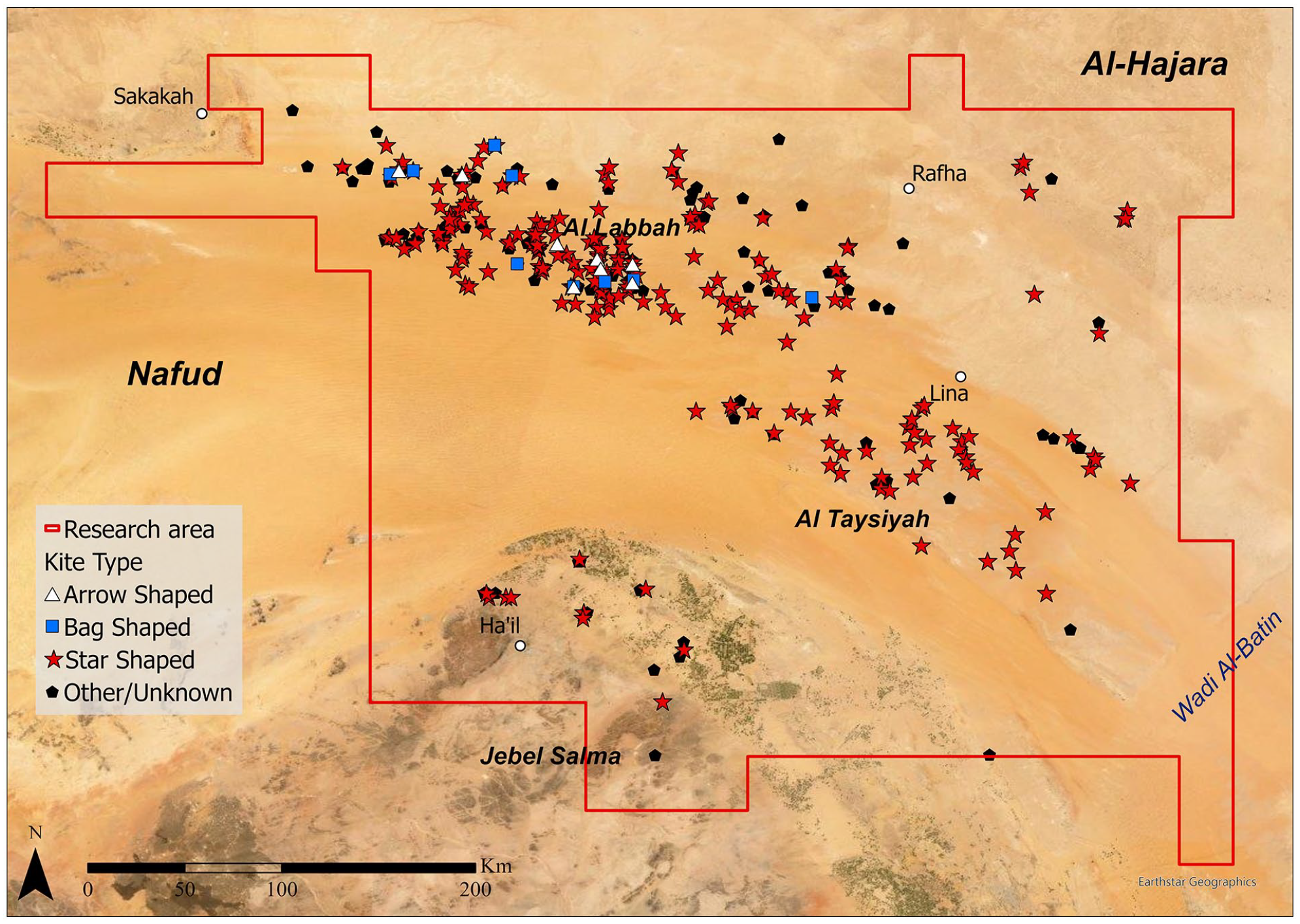
The systematic remote sensing survey of the eastern Nafud region has to date recorded a total of 354 kite structures. The majority of these features had not been previously documented apart from 15 structures identified in the region of Ha’il to the south published by Groucutt and Carleton (2021). The kites are broadly distributed, fanning out from north-west to south-east, and as will be discussed further below, appear to form a continuation of the known distribution of kites running through Syria, Jordan and to the west of this study’s survey area in northern Saudi Arabia (Figure 2). Alongside the kite structures, a range of other structures were also documented across the region, including a range of cairn-form monuments and a small number of mustatil structures, the latter confined to the southern section of the survey area in the vicinity of Ha’il (Figure 3).
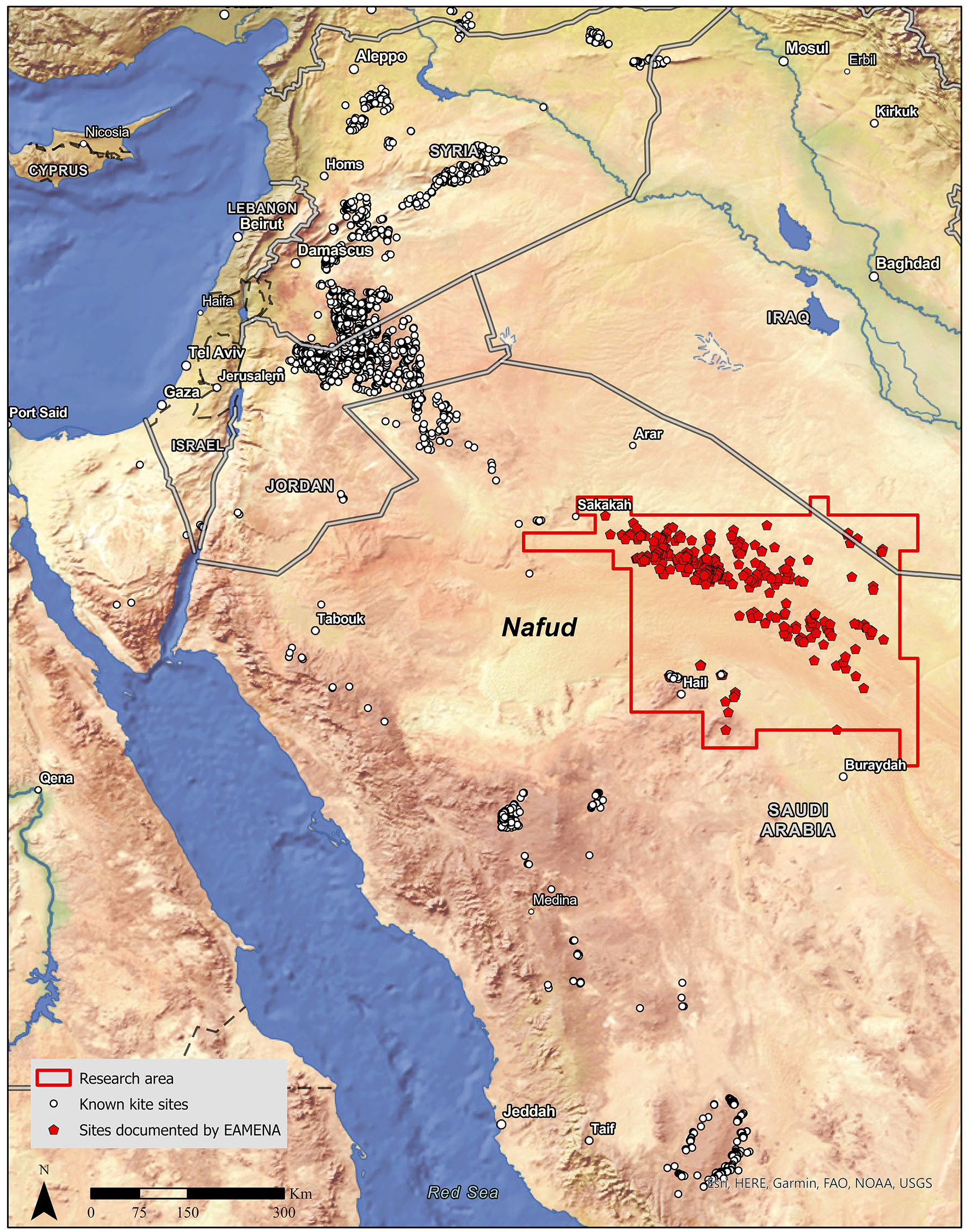
Distribution of kite structures in the Levant and in northern Arabia. White: previously documented kites. Red: kites recorded by EAMENA.
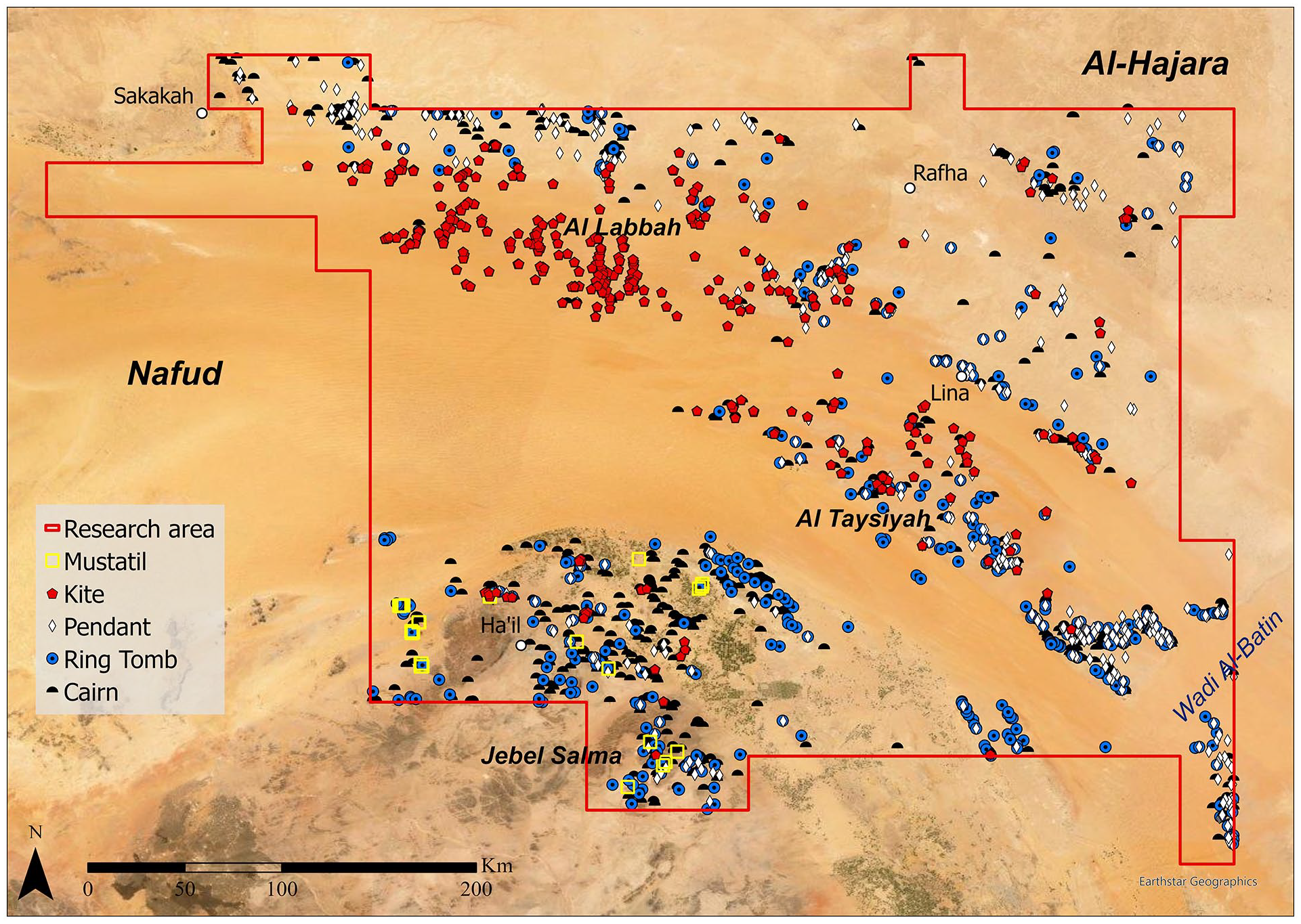
Research area showing the distribution of recorded kites, mustatil, cairns, pendant cairns and ring tombs in the study area.
The more widespread cairn-form structures can be broken down into the morphological categories of simple circular stone mounds, ring tombs consisting of a central cairn with a frequently concentric surrounding wall, and pendant or tomb-with-tail structures, where a cairn ‘head’ has a linear wall ‘tail’ (for a description of cairn types see for example Dalton et al., 2022; Kennedy, 2011). There is some crossover in these forms, particularly in the crossover between ring tombs and pendants, where pendants have ring tomb ‘heads’. These monument forms can be broadly dated to later-prehistory, and in many cases may have functioned as funerary or ancestral memorial structures, although the low number of excavated examples in this region limits their interpretation. These forms are found in different concentrations across all rocky/raised areas in the survey area, with the notable exception of the Al Labbah plateau where the principal concentration of kites was recorded and only a small number of basic cairns were documented (Figure 3).
Over 65% of the documented kites were of the classic star-shaped kite form that is also prevalent in eastern Jordan (Abu-Azizeh et al., 2021; Groucutt and Carleton, 2021). In addition, more than 25% of documented sites remained unclassified because the form of the ‘head’ was not visible on satellite imagery, either because the fabric from the head structures had been eroded, re-used elsewhere, covered by sand or possibly because no head had been built (Figure 4). Many of the surviving star forms were elaborate structures with large numbers of cells visible at the star points, in some cases numbering more than 10 points. This pattern continued even in the peripheries of the distribution, for instance the dispersed group on the Iraq border was made up primarily of star shaped kites and there are examples with as many as 16 visible cells (Figure 5). Additionally, a small number of arrow (n:8) and bag (n:9) kites which are also known from eastern Jordan were identified, but were confined to the north-western section of the survey area (Figure 6).
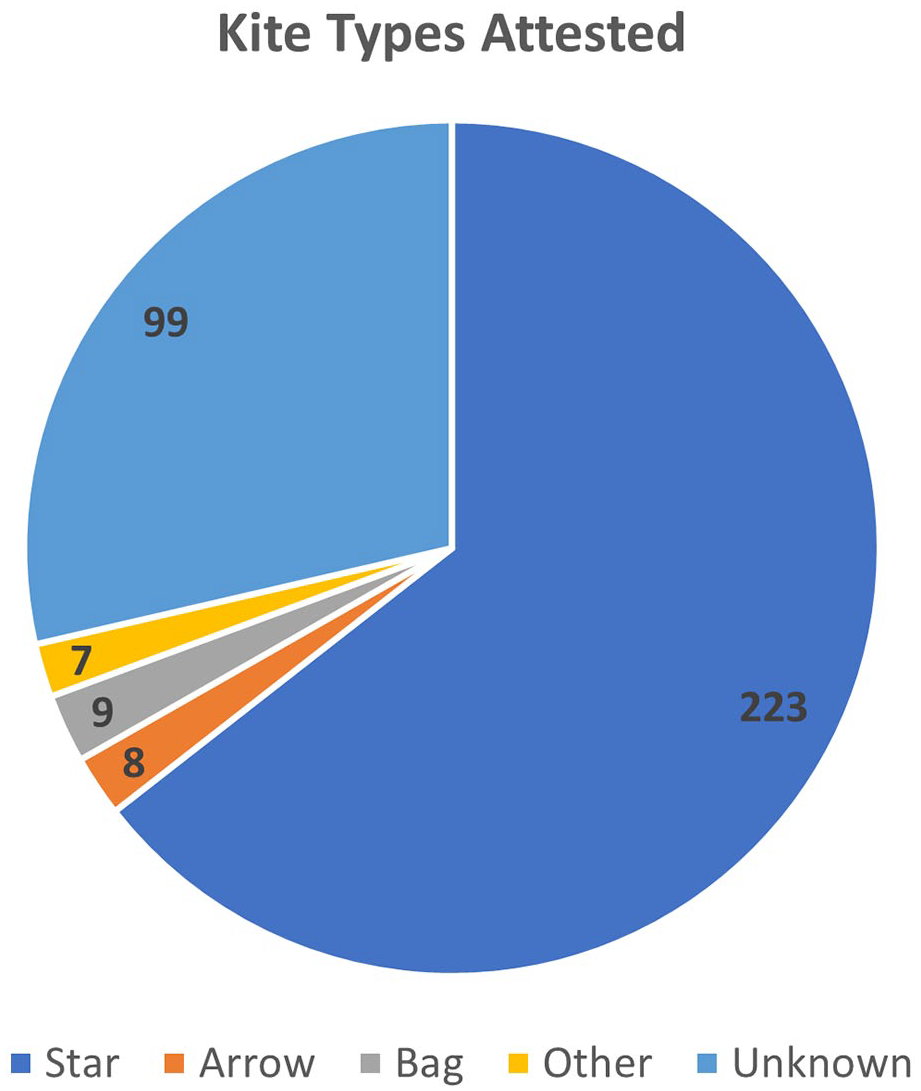
Number of kites by type (as defined by Brunner, 2015a).
Distribution of star-shaped and other kites in the survey area.
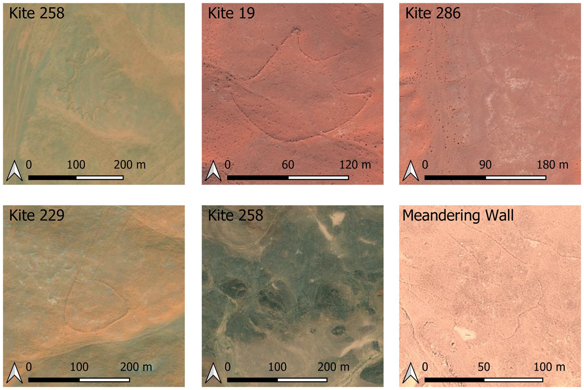
Satellite images showing the broad kite types (and meandering walls) recorded in the survey area.
There is a strong repetition of kite orientation in the documented distribution, with kite heads situated to the west and the driving walls leading out to the east (Figure 7). This orientation is based on the apparent ‘entrance’ to the kite head, as the multiple walls can run in widely varying or curving orientations. This use of entrance orientation is complicated by cases where the kite head has been reconstructed with an entrance on a different orientation. There is some variation in eastern orientation, primarily from north-east to south-east. This is broadly in line with orientation recorded in kites in eastern Jordan where ‘heads’ were recorded predominately to the north-west (Betts and Burke, 2021).
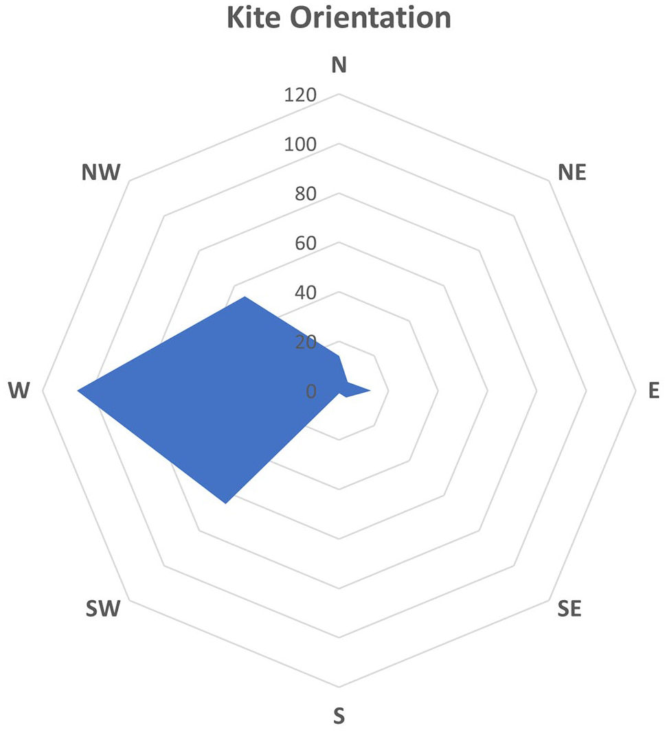
Orientation of kite ‘heads’, predominately located at the western end of the structure.
Limited analysis of the gradient approach to a kite head was carried out on 50 selected kites by constructing an elevation profile following a route between the visible kite string walls and using a freely available Shuttle Radar Topography Mission one arc-second DEM (with a 30 m resolution and an absolute vertical accuracy of ±16 m). While the accuracy of the DEM data has not been assessed and verified on the ground, this data would suggest that the final approach to the kite head is frequently on a downslope (Figure 8), so in some sense hidden from view, repeating trends seen in kites elsewhere (Abu-Azizeh and Tarawneh, 2015; Crassard et al., 2022; Groucutt and Carleton, 2021; Morandi Bonacossi and Iamoni, 2012). The trend seen in the study area is that most of the approach (84%) is on an upslope gradient (Figure 8), contrasting with a small sample analysis of kites from south-east Jordan where the approach is generally downslope, with a sharp drop of elevation near the kite head (Abu-Azizeh and Tarawneh, 2015). Given our limited sample size, there could still be a range of variation over the longer approach in our study area.

Selected examples of elevation profiles of kites in our research area. The origin corresponds to the centre of the ‘head’ while the last point corresponds to the end of the preserved string walls.
Twenty-two examples of meandering walls or clusters of walls were identified in the survey area. The curvilinear form of these features is potentially difficult to distinguish from geological formations across the region. Nevertheless, it is still notable that the walls occur in two principal clusters in the northern section of the survey area, on the plateaus on the north side of the Nafud. Seventeen of these wall locations occur in one of these areas, while a single outlier was recorded on the At Taysiyah plateau. These groupings occur in areas where kites and cairn forms are also documented, although away from the heaviest kite density of the Al Labbah plateau.
Variations of cairn structures were recorded in varying densities across most of the research area outside of the sand sea. This distribution was notably sparse in the area of the Al Labbah plateau where the densest concentration of kite structures were recorded, but only five basic cairn structures were recorded and with no evidence of more complex pendant or ring tombs. There are dense concentrations of some complex cairn forms, particularly in areas around the Ha’il oasis and the ridge that makes up the southeastern extent of the At Taysiyah plateau overlooking the Wadi al Batin (Figure 3).
In terms of visible chronological stratigraphy, the most common association in the survey area was the construction of sub-circular enclosures either over or abutting the walls of kite structures, generally in the vicinity of the kite head. These structures are not dated and are anecdotally linked with pastoral activities – potentially until the recent past. In the case of cairn structures, evidence of stratigraphy is less clear, although in many cases the walls of the kites are less visible or well-preserved, suggesting that the structural fabric may have been robbed to construct the cairn. The only stratigraphic relationship between a kite and mustatil, along with cairn structures, has previously been published in the Ha’il region (Parr et al., 1978). In this case the mustatil and cairn structures appear to be built over the earlier kite structure, and again the kite walls are poorly preserved. While there are few examples of clear structural stratigraphy, there is no evidence of any kites being built over any cairns (or mustatils) recorded in the survey area.
Discussion
This new distribution of kite structures further transforms our understanding of the geographical contexts in which these monuments were built across northern Arabia, as well as providing a number of avenues through which we can consider how they were utilized and perceived. This will be explored through an analysis of the overall site distribution, chronological setting, architecture and finally, through consideration of this site form from the perspective of monumentality.
The documented kite types, predominantly star-shaped kites with a small number of arrow and bag kites, show distinct morphological similarities with kites documented in Jordan (e.g. Abu-Azizeh et al., 2021; Helms and Betts, 1987) and contrast with forms dominant in western Arabia (Groucutt and Carleton, 2021). This similarity is strongly indicative of a close association between the kites in the eastern Nafud and in Jordan/Syria, suggesting that people or concepts had moved between the two areas. It may be relevant that the small number of arrow and bag forms were limited to the north-western part of the survey area, closest to eastern Jordan, if they are chronologically earlier kite forms (e.g. Betts and Burke, 2021). This would suggest that this spatially marks the limit of early use in the area, and that in general the kite building tradition was coming into the area from the north-west. Examples of ‘meandering walls’ were also documented in the eastern Nafud region. Analysis of these forms in Jordan suggest a phased sequence in which the meandering walls are the earliest structures, followed by the bag form and culminating in the complex star-shaped form (Betts and Burke, 2021: 206–207), although this position has not been conclusively demonstrated. As the density of kite forms is much lower in the eastern Nafud there is no comparable stratigraphy of different kite types, and where there was evidence of overlying kites it involved only star-shaped forms.
A common repetition of kite orientation was also recorded in the eastern Nafud region, mirroring the repetition of direction that has also been observed in Jordan, where it has been predominantly understood in terms of hunting strategies linked to the movement of gazelle migration at some scale, or at some level a seasonal indicator of when hunting took place (Chambrade and Betts, 2021; Crassard et al., 2022; Helms and Betts, 1987). To these inferences we can add the possibility that such a mechanism with the east-west repetition recorded in the Nafud could conceptually have been used in a sunrise or sunset context, using low light to ‘blind’ gazelle as they moved towards kite heads. However, this could relate towards using such a method to dazzle animals as they move forward towards a kite head, or using a dazzling effect behind the animals to discourage them from turning back away from a kite head if disturbed.
Distribution
In terms of the overall distribution of kites in our survey area it seems clear that the distribution follows the alignment of the eastern Nafud, and from this a tentative inference that this may relate to the principal habitation or migration grounds of gazelle or other game species. The principal band of kites are located along the eastern Nafud, with the highest concentration on the Al Labbah plateau, while smaller concentration are found to the south around Ha’il and on the Iraq border. A solitary possible kite in the south-eastern extent of the survey is a notable outlier in the dataset (Figure 5), and sampling beyond has not identified further examples. In reference to the apparent gap between the main central distribution and the Ha’il group, it is feasible that further structures may have been completely buried in the intervening zone given that several kites in the central group were found to have been partially buried beneath the shifting sands of the Nafud. Alternatively, gazelles and other wildlife may have avoided these areas or the gap may simply be the result of a lack of local material for construction.
Topographically this group of kites as a whole run along the northern broad subdivision of the Interior Homocline of the Arabian Shelf (Alsharhan et al., 2001: 7–10). Geologically there is a visible correlation between this extension of the Syrian/Jordanian kite distribution and the Cretaceous limestone formations extending across the eastern Nafud (Figure 9). This does not appear to be a result of geological visibility of these structures, but rather seems to have had a clear impact on the areas in which these kites were constructed, perhaps related to the availability of building materials, or to water retention and consequently more favourable habitats for wildlife. However, the kite distribution does not correlate completely as the geological band extends northwards into the Widyan region in which visible kite structures are completely absent, suggesting it was not simply related to the availability of building stone across this geological zone. The more dispersed northern distribution extends into southern Iraq and runs over areas of limestone and Permian sandstone foundations.
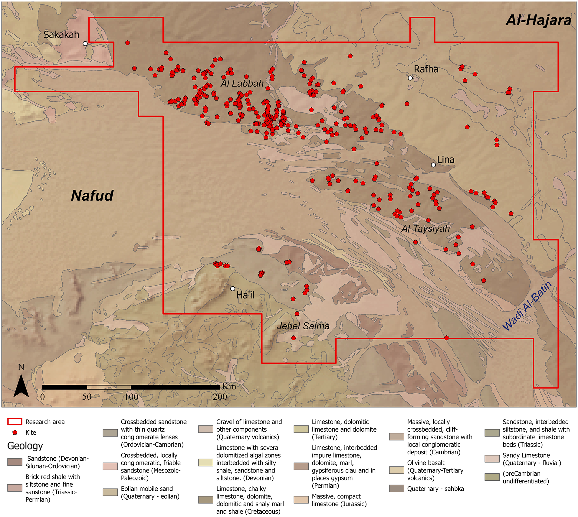
Distribution of the kites on different geology. The basemap is an adaptation of Pollastro, 1998a, 1998b) and the Geological Map of the Arabian Peninsula created by the U.S. Geological Survey (1963).
What is less certain is why, given the known distributions in eastern Jordan and northern Saudi Arabia, the group as a whole narrow to a spartan waist in the vicinity of Sakaka before broadening out across the eastern Nafud (Figure 2). There is also the question of why the eastern Nafud distribution ends relatively abruptly along its eastern end, prior to reaching Wadi Al-Batin and Wadi Ar-Rima. There is no significant change in the landscape morphology in this area that clearly explains why the distribution ends at this point (Al-Sulaimi and Pitty, 1995). Sampling in the southern sector of Iraq’s western desert has also not identified any further examples towards the southern Euphrates.
It is probable that our dataset does not fully capture the density or extent of desert kites across the eastern Nafud Desert. Variability in the quality of available satellite imagery is likely to have led to some sites not being observed, while the rapid survey methodology of the EAMENA project also increases the likelihood that some sites may not have been identified and documented. Examples identified on exposed rock faces between sand dunes also suggests that some desert kites may be completely buried under the sands of the Nafud. It is therefore likely that the distribution itself may be larger and that further examples of desert kites may survive beyond the systematic survey area discussed in this paper. Further analysis of the landscapes of southern Iraq would be beneficial in this respect, as well as further analysis of the region connecting this new distribution to the known examples around the Jowf region of Saudi Arabia, and the outlier grouping identified near the modern city of Ha’il.
Dating
In terms of chronology, this study is dependent on the limited results from research on comparable kite forms in Jordan and western Arabia (Abu-Azizeh et al., 2021; Al Khasawneh et al., 2019; Groucutt and Carleton, 2021; Helms and Betts, 1987; Zeder et al., 2013). However, some examples of structures built over earlier structural forms were visible on the satellite imagery and provide evidence for a relative chronology. A number of sites across the northern part of the distribution appear to have had various types of cairn tombs built over earlier kite structures, presumably re-using fabric from the kite. While simple cairn forms occur across a wide date range from the Neolithic onward, as demonstrated by work in Jubbah and in the southern Nafud (Groucutt et al., 2020; Guagnin et al., 2017a), the more complex pendant and ring tomb monuments can be broadly placed into the Bronze Age and later periods, with a recent excavation of a pendant in western Saudi Arabia providing a date range in the third millennium BCE (Kennedy et al., 2021). More frequent is the re-use of kite sites for the construction of amorphous walled enclosures, likely related to the corralling of livestock, which are rarely dated via fieldwork and sit within an even broader chronological span that may well stretch into the 20th century.
A more specific relative chronology can be identified in the Ha’il distribution with a mustatil/gate structure built over the head of a star-shaped kite, with potentially later cairn structures built around the same site. This example was first published by Parr et al. (1978) and was recently reassessed by Groucutt and Carleton (2021) in an analysis of kite concentrations in central Arabia. Although mustatils are relatively newly defined as a distinct type of archaeological monument, recent excavations have produced calibrated radiocarbon dates between the later sixth and the early fifth millennium BCE (Groucutt et al., 2020; Thomas et al., 2021). This currently fits with the dating of star-shaped kites in Jordan, placing them significantly earlier in origin than the mustatil structures.
The results of this remote-sensing survey cannot directly contribute to ongoing debates over the absolute chronology of the kite phenomenon. However, the data can provide some insight into their relative chronology. This can be drawn out most clearly on examination of the distributions over the Al Labbah plateau, where the densest concentration of kite structures was recorded within the study area. This is in contrast to cairn structures, which are distributed along the southern and northern edges of the Nafud desert and across the At Taysiyah plateau in the south-east (Figure 3). In northwestern Arabia, pendants and ringed cairns, which are frequently aligned along routes, forming ‘funerary avenues’ have been attributed to the late middle Holocene, between the late third and first millennium BCE (Dalton et al., 2022; Kennedy, 2011). Although there is still some uncertainty around their age, their distribution suggests that they may be associated with access to water, placing them in the arid period after the end of the HHP (Dalton et al., 2022). The fact that structures associated with arid conditions are not found on the Al Labbah plateau indicates that the dense distribution of kites in this region may relate to the more favourable environmental conditions of the HHP. This correlation is further supported by the Neolithic date of recently dated kites in eastern Jordan (Abu-Azizeh et al., 2021; Al Khasawneh et al., 2019; Helms and Betts, 1987).
Considering the tentative chronology of kite construction in the Levantine and Mesopotamian Pre-Pottery Neolithic, it appears that by the time populations were raising cairn structures along the eastern Nafud, conditions had changed and the Al Labbah plateau was no longer a focus for these activities. In contrast, numerous cairn structures were recorded on the more prominent At Tasiyah plateau, with highest densities along the south-eastern end overlooking the channel of Wadi Al-Batin. The latter may have provided a viable avenue for overland travel between central Arabia and southern Iraq, which may explain the concentration of funerary activity on the southern section of the at-Tasiyah plateau.
Importantly, although kite construction on the Al Labbah plateau may have been largely confined to the HHP, it appears to have been utilized extensively during this time period. As in other areas of the Middle East (Betts and Burke, 2021), analysis of satellite imagery showed that a minimum of 44 kites were rebuilt at least once, strongly indicating that these structures were used over a prolonged period. The presence of multiple kite types, and ‘meandering wall’ features may also indicate an evolution of structures over time (e.g. Betts and Burke, 2015, 2021).
Monumentality and connectivity
There is now a general consensus that kite structures played a role in the hunting of wild game (e.g. Crassard et al., 2022). Considerable resources would have had to be coordinated to build and maintain kites, undertake hunts and return butchered remains to settlements or camps for further preservation. This final point would have created a particular challenge in the eastern Nafud as kite structures stand isolated from any known areas of early or mid-Holocene settlement.
Another element of this process that has not been explored is the understanding of the kites of this region as an expression of monumentality. While the structures were vertically limited, barring evidence of the deep, stone-lined pits in the cell features, they were horizontally massive and display evidence of complex, careful design (Figure 10). From the design of the kite heads to the careful runs of guiding walls over long distances, these structures contrast markedly in scale with any other evidence of early Holocene architecture. This is particularly distinct in the Al Labbah plateau, where there is little evidence of any structural forms that could relate to settlement or funerary activity, and we can conjecture that the builders of these kites dwelt in temporary, organic material structures that have left no trace visible on current satellite imagery data. Similar, structure-less, highly mobile lifestyles have also been documented in the Jubbah oasis, in the Arabian interior and along the Gulf coast (Guagnin et al., 2021).
Example of multiphase construction/use, Kite 23/ EAMENA-0194145.
This perception of the kite as a form of monumentality, through the exaggeration of scale and form as an expression of status, identity and territoriality, provides one model for understanding the apparent development of increasingly complex kite forms, and why this would have had no clear improvement in hunting capabilities (Betts and Burke, 2021). The monumentality of kites also complements a wider recognition of their place within the symbolic and ritual spheres of Neolithic peoples in the region, as demonstrated by their appearance in rock art (Hill et al., 2020), and associated with carved human figures and a deposit of marine fossils at Jibal Al-Khashabiyeh in the south-east Badia (Abu-Azizeh and Tarawneh, 2022). Kites clearly formed a central role in terms of identity among social groups in the region. A semi-controlled hunting environment, that may also have enabled greater participation among a wider demographic than ‘open’ hunting, the process of construction, elaboration and use may have had an additional, ritualized element that fed in to the social cohesion of these groups. The wholesale reconstruction of kites over the footprint of an earlier structure, rather than the piecemeal repair and adaptation, may also have been driven in part by perceptions of a kite ‘lifecycle’ and the changing dynamics of hunting communities.
Taking this concept of monumentality and identity forward, we can tentatively identify an interesting correlation in the distribution of the star-shaped kites of the Nafud with the arrival of a very different monumental structure in the form of the late Neolithic mustatil (Groucutt et al., 2020). The limited absolute dating of mustatils and Jordanian kite forms currently supports a model in which kites were constructed from at least 8000 BCE (e.g. Abu-Azizeh et al., 2021), while mustatils were built from at least 5200 BCE (e.g. Thomas et al., 2021). Early research on mustatils has also tentatively identified a possible ritual connection of these structures to a form of cattle cult (Thomas et al., 2021), which contrasts with the interpreted use of kites for hunting wild game. Although we can currently assume that the kite forms discussed here were almost certainly first being built several millennia before the mustatils, the probable longevity of the construction, reconstruction and continued use of the kite structures may have seen the two monumental traditions overlap chronologically, and to an extent geographically. This aspect is highlighted in the new distribution presented here, where the two monumental traditions overlap in small numbers around the Ha’il oasis, yet the mustatils do not appear to have been built further north into the Nafud, and the kite forms of the Nafud have not been identified further south or west into central Arabia. It is therefore possible that some form of cultural limit existed between people over a longue durée between the landscapes where these two distinct types of monumental stone structures were built.
The distribution of star shaped kites documented in this paper provides new evidence for contact across the Arabian desert during the HHP (Figure 11). To date, finds of Levantine lithic forms at northern Arabian Neolithic sites, as well as the presence of gold in a context radiocarbon dated to between 3634 and 3382 BCE at Jebel Oraf, provide evidence of repeated contact that continued over several millennia and may have been driven by the extreme mobility that characterized Neolithic sites in the Nefud region and along the Gulf coast (Carter, 2018; Guagnin et al., 2021; Scerri et al., 2018). Further evidence has recently also been documented in the distribution of large camel engravings that were repeatedly re-worked by the same hand, and thus document the repeated movement of individuals across or around the Nefud desert (Charloux et al., 2022). Along the Gulf coast, trade with ‘Ubaid pottery is well documented throughout the sixth and fifth millennia BCE, likely a result of maritime trade, and it is possible that date products were traded in exchange (Carter, 2018). Moreover, the introduction of domesticated livestock was the result of either contact with, or migration from the Levant into the Arabian Peninsula (Crassard and Drechsler, 2013), although the routes along which pastoralism found its way into Arabia remain unclear (Drechsler, 2009; Makarewicz, 2020). In the context of this extreme connectedness, the distribution of the star-shaped kites now provides the first direct evidence of contact through, rather than around the Nafud desert, underlining the importance of areas that are now desert had under more favourable climatic conditions in enabling the movement of humans and wildlife. The distribution of star-shaped kites also documents a clear affinity with the Levantine Neolithic for the northern and eastern Nefud region, which stand in some contrast to the region southwest of the Nafud desert, where Jubbah style rock art and mustatil structures document distinct local traditions. Although the spatial distribution of these structures gives some insight into the population dynamics of the Neolithic, future research needs to address to what extent kites and mustatils may have overlapped chronologically.
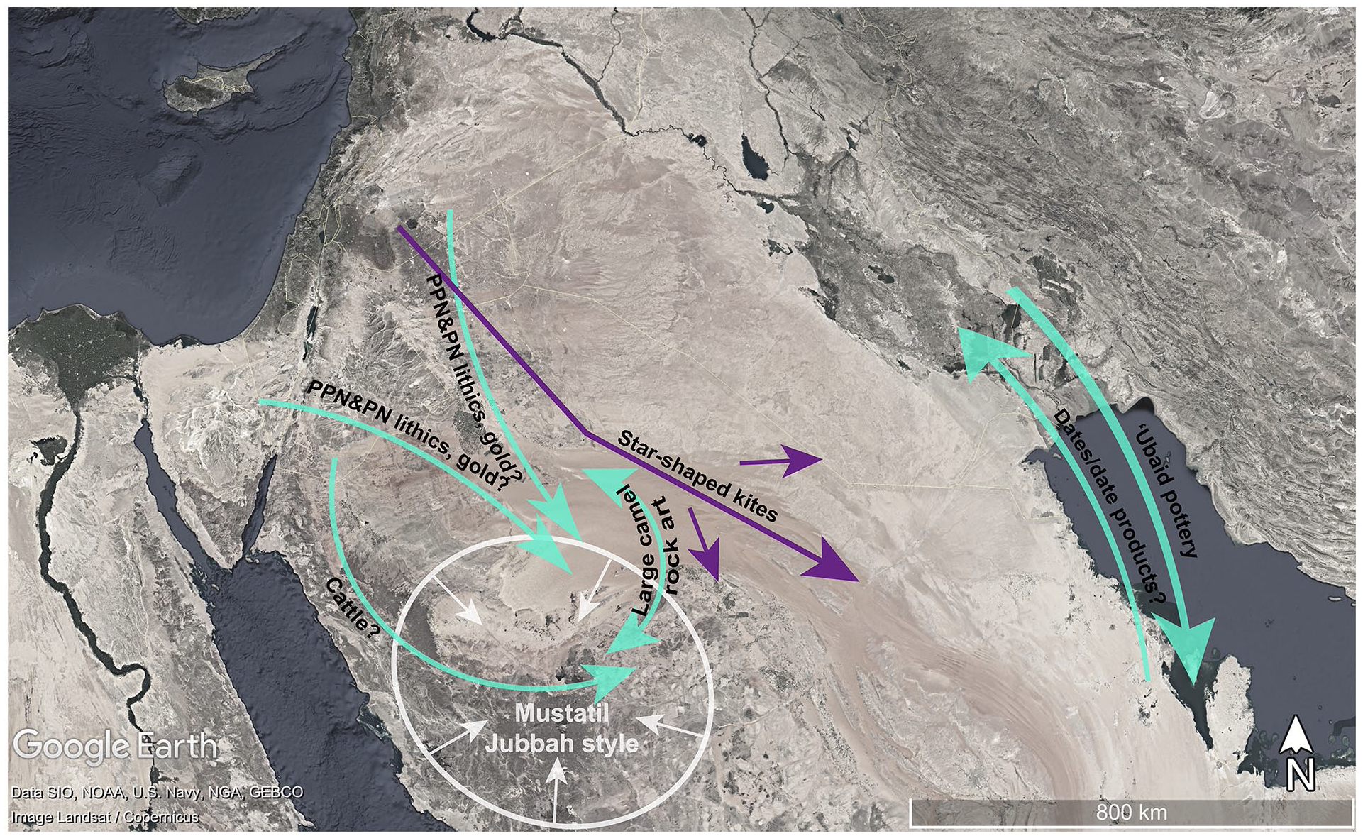
Known connections during the HHP (green) contrast with the localized phenomenon of mustatil structures and Jubbah style rock art (white) (Guagnin, 2020). PPN and PN lithics as well as gold show repeated contact with the levant (Guagnin et al., 2021). Cattle are thought to have been introduced via southern Jordan (Makarewicz, 2020) and ‘Ubaid pottery was traded along the Gulf coast, possibly in exchange for date products (Carter, 2018). Large engravings of camels also show evidence of repeated contact across the Nefud desert (Charloux et al., 2022). Arrows placement is approximate and used to symbolize the general direction of connections.
Conclusion
The new distribution of kites presented in this paper represents a major geographical extension of the long-recognized kite groups from eastern Jordan. The identified distribution of kites shows some correlation with the underlying limestone strata, and this in turn may link to groundwater influx and retention that may have made this marginal environment habitable in the HHP. On the basis of the current dataset, it is inferred that at this time parts of the eastern Nafud, notably the Al Labbah plateau, could support wild game herds and that human groups were involved in hunting them. These human groups were able to invest in the monumental construction, and in some cases reconstruction, of kite architecture. It is conjectured that at a later part in the Holocene the environment changed and the Al Labbah plateau became no longer habitable, based on the absence of later forms of stone structures such as the pendant or ringed cairns that occur regularly around the periphery of the Nafud. This environmental change could potentially have occurred as early as the sixth/fifth millennium BCE with the arrival of mustatil monuments to the south around Ha’il, but at least by the time that pendants and ringed tombs were being constructed in the region in the third through to the first millennium BCE.
There is a need for further excavation and ground survey to advance our current understanding, including identifying any potential contemporary camps or settlements. Targeted excavation over such horizontally large features with potentially limited vertical stratigraphy is a relatively high-risk sampling model. This new distribution offers an opportunity to at least develop strategies for exploring the dominant northern Arabia kite-type, as a large part of this group is an area with little to no evidence of later human activity and disturbance that may archaeologically contaminate the site, at least as far as visible on satellite imagery. More importantly, located on limestone beds away from the basalt regions, there is also the potential to employ geophysical methods to identify areas of human activity, particularly away from the kite heads and ancillary cells that are the focus of most ground investigation.
This new distribution transforms our understanding of an era of connectivity across northern Arabia during the HHP. Our research shows that previous perceptions of the kite phenomenon extending and developing across western Arabia are incorrect, and instead we can see that the kite forms typical for eastern Jordan and Syria extend across the eastern Nafud. Whether this represents the movement of ideas or people, and even the direction of that movement, remain questions to be answered. Nevertheless, this new remote-sensed data provides the basis for a range of new research questions and an imperative to intensify fieldwork in the ‘empty’ landscapes of the eastern Nafud.
Footnotes
Acknowledgements
We would like to thank Bill Finlayson, Thomas Huet and members of the EAMENA project for discussion and comments on this paper. Comments and feedback from Rebecca Repper and Professor David Kennedy, as well as Chad Hill and Yorke Rowan also helped improve this paper, as did the input of two anonymous reviewers. We would also like to acknowledge that Professor David Kennedy and Rod Trinca had already identified a number of the kite structures discussed in this study, independent of the EAMENA project.
Funding
The author(s) disclosed receipt of the following financial support for the research, authorship, and/or publication of this article: The research was supported by the Arcadia Fund, a charitable fund of Lisbet Rausing and Peter Baldwin (grant number 4178).