
Abstract
The desert regions of the Arabian Peninsula and Levant are criss-crossed by innumerable pathways. Across large areas of north-west Arabia, many of these pathways are flanked by stone monuments, the vast majority of which are ancient tombs. Recent radiometric dating indicates that the most abundant of these monuments, elaborate and morphologically diverse ‘pendant’ structures, were constructed during the mid-to-late third millennium BCE. Thousands of kilometres of these composite path and monument features, ‘funerary avenues’, can be traced across the landscape, especially around and between major perennial water sources. By evidencing routes of human movement during this period, these features provide an emerging source for reconstructing important aspects of ancient mobility and social and economic connectivity. They also provide significant new evidence for human/environment interactions and subsistence strategies during the later Middle Holocene of north-west Arabia, and suggest the parallel existence of mobile pastoralist lifeways and more permanent, oasis-centred settlement. This paper draws upon the results of recent excavations and intensive remote sensing, aerial and ground surveys in Saudi Arabia to present the first detailed examination of these features and the vast cultural landscape that they constitute.
Keywords
Introduction
The desert regions of the Arabian Peninsula and Levant are crisscrossed by innumerable pathways, often identifiable on the ground and even more so from the air by visible erosion, stone clearance and wear. Whilst some have likely been formed by wild ungulates or free-roaming domesticates, others evidence the movement of people and their herd animals across these landscapes, from the distant past through to the present (Huigens, 2018). The same regions also preserve millions of drystone Holocene monuments, known collectively to Bedouin as ‘the works of the old men’ (Kennedy, 2011, 2020; Maitland, 1927).
In large areas of north-west Arabia, pathways are often flanked by highly variable densities of monuments, including ringed and un-ringed cairns, small circular towers and, most numerously, tailed ‘pendant’ structures (Figure 1; see below). The vast majority of these structures can be interpreted as tombs, due to the presence of a stone-lined burial chamber. Pendants, which are frequently oriented toward these paths, have yielded human remains dating to as early as the mid-third millennium cal. BC (Kennedy et al., 2021; below). After Kennedy (2011), we refer to these composite path and monument features as ‘funerary avenues’. While ancient pathways are notoriously difficult to date (e.g. Ur, 2009), the analysis of associated monuments may allow for the partial temporal contextualisation of their formation and use.
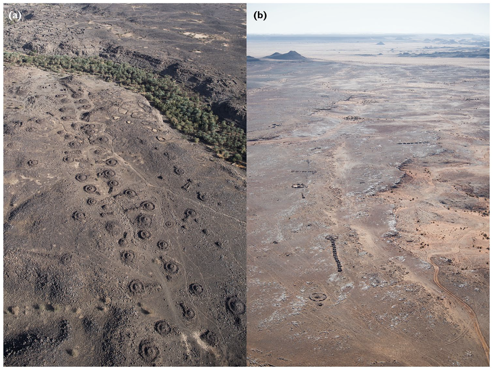
(a) A dense funerary avenue with ‘wedge-tailed’ pendants and infilled ringed cairns (site IDIHA-0027955), emanating from Khaybar Oasis. (b) A sparse funerary avenue consisting of various pendant types oriented towards a series of pathways formed over sandstone terrain (IDIHA-0013832; IDIHA-0013645; IDIHA-0013643).
To introduce this widespread but as yet poorly understood phenomenon, this paper draws upon datasets derived from satellite imagery analysis, aerial photography, ground survey, excavation and radiometric dating carried out by the University of Western Australia’s ongoing Aerial Archaeology in the Kingdom of Saudi Arabia – AlUla (AAKSAU) and Khaybar (AAKSAK) projects. This paper uses these multiscalar sources to reconstruct funerary avenue routing and define the spatial and chronological specificity of the monument types that constitute them. In the context of regional environmental and cultural trends, we then discuss the potential of these impressive features to reveal important aspects of Middle Holocene lifeways.
Background and research problems
Until recently, the pre- and protohistoric archaeological landscapes of north-west Saudi Arabia have been subject to only highly selective investigation, such as that undertaken by the Comprehensive Archaeological Survey Program in the 1970s–1980s (Al-Rashid, 2005). The advent of ‘windows’ of freely-available, high-resolution satellite imagery from the early 2000s provided new insights into the astonishing density and diversity of the region’s prehistoric monuments (e.g. Kennedy, 2011, 2012; Kennedy and Bishop, 2011). Over the past decade this situation has improved dramatically, with almost all of this area now covered by such imagery. This allows for near-comprehensive assessments of the distribution of suitably visible features, including many of the monuments and pathways analysed here.
Meanwhile, official initiatives have provided renewed opportunities to carry out intensive archaeological fieldwork in the region. The AAKSAU project, commissioned in 2018 (Thomas et al., in press), is part of the large-scale archaeological landscape survey and targeted excavations commissioned by the Royal Commission for AlUla (RCU), as part of the Identification and Documentation of the Immovable Heritage Assets of AlUla programme (IDIHA). The RCU was established to develop the archaeologically rich AlUla County into a world-class visitor destination, with heritage and archaeology forming key components of this endeavour. The AAKSAK project was commissioned in 2019, after the RCU incorporated areas of Khaybar County into its remit. The projects’ teams have carried out systematic satellite imagery analysis, hundreds of hours of helicopter-based aerial reconnaissance and photography, extensive ground survey and selective excavation in major parts of both AlUla and Khaybar counties, a combined area of ~42,500 km2 (Figure 2).
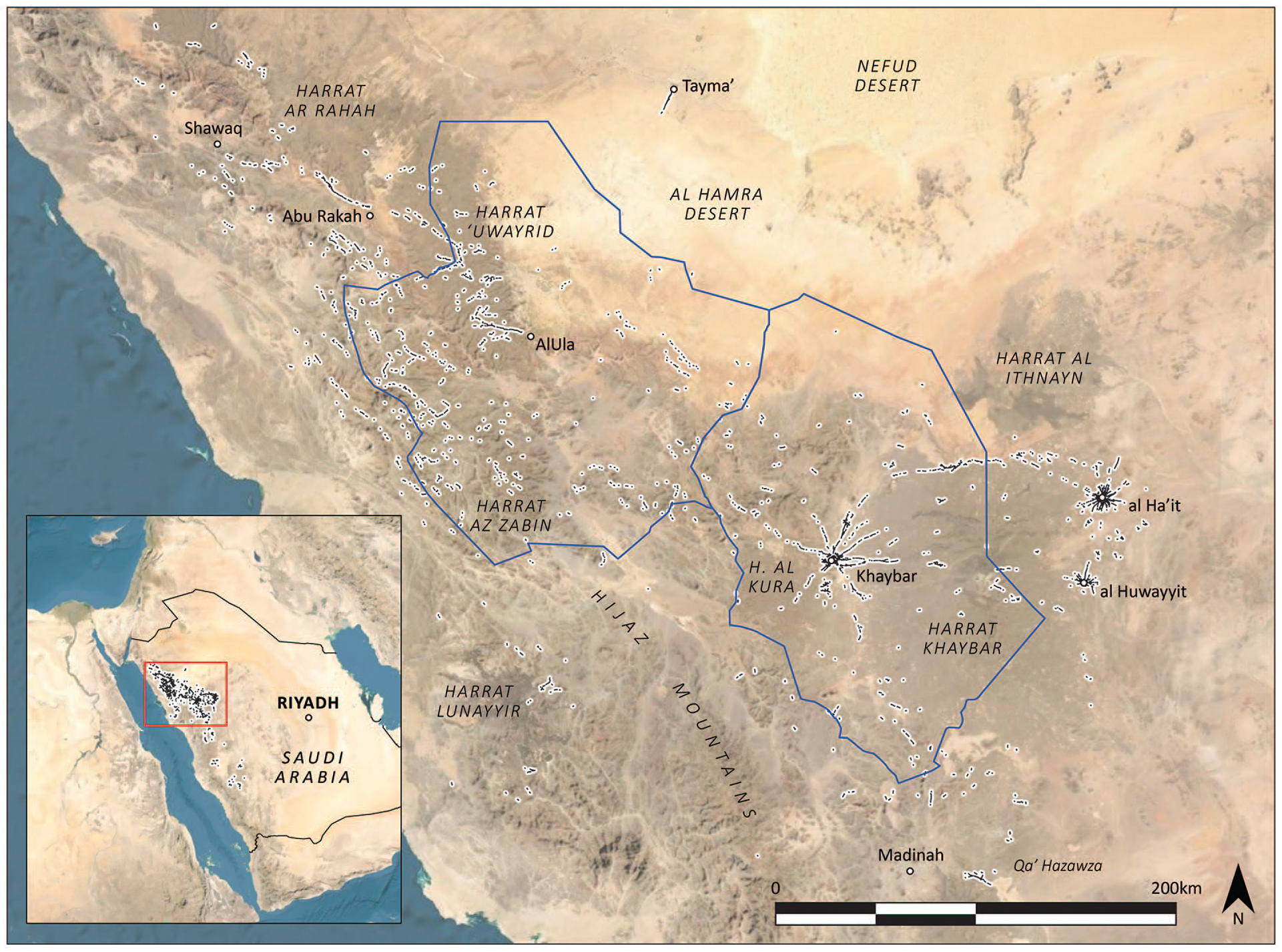
Overview of funerary avenue segments identified in part of north-west Saudi Arabia, showing AlUla and Khaybar counties (blue outlines) and major landforms including Cenozoic lavafields (harrah). Most avenues located elsewhere (cf. inset) generally have a more ambiguous relationship to identifiable pathways (see below).
These projects are part of a recent intensification of archaeological investigations of pre- and protohistoric north-west Saudi Arabia, both at significant foci of settlement such as Tayma’ (e.g. Hausleiter, 2011; Hausleiter and Eichmann, 2018), Qurayyah (e.g. Luciani and Alsaud, 2018; Luciani et al., 2018) and Dūmat al-Jandal (Charloux et al., 2014), and across the landscape more widely (e.g. Petraglia et al., 2015, 2020; Scerri et al., 2018). This research is demonstrating the region’s centrality to important debates on prehistoric lifeways and human/environment interactions, including the regionally diverse trajectories of Neolithisation that took place here during the Early to Middle Holocene 1 (e.g. Crassard and Drechsler, 2013; Guagnin et al., 2016, 2017) and the emergence of oasis agriculture and water management techniques (see below).
The prehistoric funerary monuments of the southern Arabian Peninsula have already attracted significant investigation (e.g. Braemer et al., 2001; Cleuziou, 2002; De Maigret, 1996; Guy et al., 2020; McCorriston et al., 2011; Weeks, 2010 and contributors; Williams and Gregoricka, 2019 and contributors), as have those of the Levant (e.g. Bradbury and Philip, 2011; Haiman, 1992; Prag, 1995; Steimer and Braemer, 1999; Zohar, 1992). However, in west and north-west Saudi Arabia, and in adjacent desert landscapes of eastern Jordan and southern Syria, these structures have received limited attention until recently (e.g. Abu-Azizeh et al., 2014, 2020; Akkermans and Brüning, 2017; Fujii, 2016; Hausleiter and Zur, 2016; Kennedy, 2011, 2012; Kennedy and Bishop, 2011; Rowan et al., 2011; Thomas et al., 2021a).
Dense arrays of path-oriented monuments in north-west Arabia were first reported by Kennedy and Al-Saeed (2009) and Kennedy (2011). Earlier, pendants near Khaybar Oasis (but not their orientation to pathways) were described by the Comprehensive Archaeological Survey Program team (Gilmore et al., 1982), and an aerial photograph of impressive ‘Neolithic’ funerary avenues in nearby al Wadi was published by volcanologists working in the region (Roobol and Camp, 1991a: Figure 13). Excepting brief mentions (e.g. Hausleiter and Zur, 2016: 165; Kennedy, 2020; Vigliotti et al., 2018), little else has yet been presented on this phenomenon.
Pendants are not unique to north-west Arabia. However, these structures’ arrangement alongside and orientation towards identifiable pathways is a key feature of our study area, although parallels in positioning and visibility can be drawn elsewhere (see below). Meanwhile, the incredible density of prehistoric funerary monuments surrounding some oases in this region finds no equivalent elsewhere. In the RCU’s 56.5 km2 Khaybar Oasis Core Zone, for example, ~9500 drystone funerary structures (including ~2800 pendants) have been recorded in our remote sensing survey (Kennedy et al., 2021: Figure 3).

Schematic drawings of pendant morphologies common in AlUla and Khaybar counties. Heads: (a–c, j–m) ‘ringed cairn’: faced circular structure enclosing an unfaced stone pile with burial chamber; (d–e) ‘tower tomb’: faced circular structure with burial chamber; (f) ‘ringed tower tomb’; as (a) with central tower tomb (as d–e); (g) ‘infilled ringed cairn’: as (a) but area between outer wall and cairn filled with loose stone; (h–i) ‘open ring’: faced circular structure with no central burial monument. Tails: (a) ‘infilled wedge’ and (b) ‘open wedge’: single or multiple adjoining faced trapezoidal structure(s) sloping upwards towards the wider end, with or without stone fill; (c) ‘segmented wedges’: straight-sided trapezoid comprising abutting open wedges of increasing size; (d) ‘infilled trapezoid’ and (e–i) ‘open trapezoid’: faced trapezoidal structure with flat top surface, with or without stone fill; (j–k) ‘triangle’: faced triangular structure with flat top surface and no stone fill; (l) ‘cairn’: single or multiple discrete, unfaced stone pile(s); (m) ‘block cairn’: single or multiple discrete, faced stone structure(s). Types: (a–b) ‘wedge-tailed’ pendants; (c) ‘segmented wedge-tailed’ pendant; (d–e) ‘tower-tomb’ pendants; (f–h) ‘keyhole’ pendants (also known as ‘keyholes’ due to their characteristic shape; e.g. Gilmore et al., 1982: 16; Groucutt and Carleton, 2021; Kennedy and Bishop, 2011; Roobol and Camp, 1991a); (i) ‘compound keyhole’ pendant; (j–k) ‘triangle’ pendants; (l) ‘cairn-tailed’ pendant; (m) ‘block cairn-tailed’ pendant. N.B. More fulsome typological descriptions are possible; e.g. (a) ‘ringed cairn with tail of multiple infilled wedges’.
Elsewhere in the Middle East, the visibility of ancient pathways has been used to infer prehistoric socio-political and economic connections between settlements, and between individual sites and their productive hinterlands (e.g. Ur, 2009; Wilkinson, 1993). Research into prehistoric connectivity in north-west Arabia is intensifying, with material culture and topography deployed to evidence links between major settlements and the wider region (e.g. Al-Hijiri, 2011; Hausleiter, 2011; Loreto, 2016). In contexts such as ours, where pathways can be identified and temporally contextualised, there is great potential to reconstruct important aspects of past human mobility, settlement and subsistence strategies. Meanwhile, the monuments situated on these avenues allow for consideration of their builders’ social structures, group identities and funerary practices.
Methodology
To define the distribution of funerary avenues, and to investigate the morphology and arrangement of their constituent monuments, we have adopted a multiscalar approach integrating satellite remote sensing, low altitude aerial photography, ground survey, excavation and radiometric dating.
Using high-resolution satellite imagery available in Google Earth, our projects’ primary study areas of AlUla (~22,562 km2) and Khaybar (~19,974 km2) counties were systematically surveyed. Grid squares corresponding to the Saudi Geological Survey’s 1:50,000 national topographic map series were subdivided into ~800 m wide (equating to 0.57 m/pixel on-screen resolution), north–south transects. Transects were inspected by trained project members. All suspected archaeological features were marked and assigned a provisional identifier containing map grid reference and interpreted type. In areas with no high-resolution coverage in Google Earth, imagery from Bing Maps was overlaid using a plug-in. This survey has identified some 164,600 suspected archaeological features, including ~17,300 pendants. Most of the monument types and pathways constituting funerary avenues are readily identifiable in such imagery using this methodology. Excepting those destroyed or masked by subsequent human development or natural agencies, we expect to have identified at least parts of most avenues present in these two large areas.
Funerary avenues clearly extend outside these two areas. Due to the features’ vast potential range (perhaps commensurate with pendants; see below), we applied a selective remote sensing survey methodology to identify them elsewhere. Many identified avenues in AlUla and Khaybar counties are associated with major water sources and Cenozoic lavafields (harrah). We therefore surveyed within a 2.5 km radius of cultivated oases in the Hijaz mountains and environs (marked as ‘palm groves’ in the detailed 1:500k K462 map series; Army Map Service, n.d.), and a 20% sample (i.e. every fifth transect) of all Saudi lavafields. Any identified avenues were tracked as far as possible. This approach provides an overview of the ‘avenue’ phenomenon’s approximate range beyond intensively surveyed areas (Figure 2). However, it is likely that further avenues will be found as systematic remote sensing of the Arabian Peninsula intensifies.
Funerary avenues were defined as segments comprising stretches of pathway and interpreted flanking monuments. To the extent visible, avenue paths were traced within an arbitrary 100 m radius of the nearest flanking monument. This approach limits erroneous avenue interpretation (important given the countless pathways identifiable across our study areas) and accounts for the discontinuous appearance of many of these features in our maps. Density was quantified for each avenue segment as number of flanking monuments per 100 m of pathway. In total, 2360 avenue segments were defined across western Saudi Arabia (Figure 2). Other likely funerary avenues (or stretches thereof) have probably eluded definition if, for example, pathways or flanking monuments were unidentifiable (see below), or if pathways extended beyond 100 m of the closest associated monument.
Major morphological variations in pendant typology are identifiable in high-resolution satellite imagery (e.g. Kennedy and Bishop, 2011). However, other significant attributes (e.g. smaller-scale variations in form, construction method, and the presence or absence of a burial monument) are often only fully discernible from detailed aerial photographs or during ground inspection. We have now undertaken low altitude (~120–300 m AGL) aerial photography of 936 of 1292 identified avenue segments (~72.4%) within AlUla and Khaybar counties. Elsewhere, single, brief aerial photographic reconnaissance flights were undertaken over Tayma’, al Ha’it, and al Huwayyit oases. Representative funerary avenues near AlUla and around Khaybar, al ‘Ayn and al Wadi oases were surveyed on the ground, and recovered human bone was subjected to 14C analysis (for full methodology and results see Kennedy et al., 2021). These studies underpin the morphological and chronological interpretations presented below.
Funerary avenues
‘Pendant’ overview
‘Pendants’ are by far the most abundant monument type constituting funerary avenues. This term was coined by David L Kennedy (2021, personal communication), and follows a tradition of applying descriptive but non-interpretative labels (e.g. ‘kites’) to distinctive stone-built structures in the region (Kennedy and Bishop, 2011). For reasons expounded below, we apply this term to the wide variety of seemingly funerary or memorial monuments across the Arabian Peninsula and Levant that exhibit a distinctive ‘head’ and one or more associated ‘tails’ (Figure 3).
In our study areas, the head of these monuments generally comprises a single funerary component – usually a circular, stone cairn or tower tomb with burial chamber. This is often situated in the centre of an open or infilled, circular perimeter wall. Some pendants were evidently never provided with a burial chamber (e.g. Figures 3h–i and 8b). It is therefore probable that such structures never actually functioned as tombs, although if unfinished they were perhaps ultimately intended to do so. Alternatively, these were possibly built as memorials (‘cenotaphs’) or for other, as yet unclear symbolic or ritual purposes (e.g. Fujii et al., 2018: 231). A pendant tail may be connected to or detached from the head, but is invariably oriented towards its centre. Tails exhibit significant diversity in form across our study areas (Figure 3; see below).
Within AlUla and Khaybar counties, most pendant heads and tails may be assigned to the morphologies illustrated in Figure 3, subject to preservation and survey methodology (for example, it is usually impossible to differentiate tails of ‘cairns’ or ‘block cairns’ in satellite imagery alone). Notwithstanding subtle variations in form (e.g. infilled or open tail monuments) and novelties such as multiple tails, most pendants within our study areas may be further categorised as one of several broad ‘types’ (Figure 3).
In published literature and in remote sensing data collected by our projects and Kennedy (cf. 2020), pendants have been recorded at least as far north as Aleppo and Palmyra, southward through the deserts and steppes of Syria and Jordan (e.g. Bradbury and Philip, 2011: 175; Kennedy and Bewley, 2004; Steimer-Herbet, 2004, 2011) into western Saudi Arabia (e.g. Kennedy, 2011; Fujii, 2016) and Yemen (e.g. De Maigret, 1996; Steimer-Herbet and Besse, 2020). In central Saudi Arabia, pendants are known from as far east as Thaj, al Kharj (Schiettecatte et al., 2013: 292) and Yabrin. Tower tombs are common in south-east Arabia (e.g. Guy et al., 2020), but tails are not reported.
Whilst widespread and morphologically diverse, the evident funerary or memorial nature of these monuments, and the concept of orientating one or more ‘tails’ towards an actual or notional burial locale, justify the use of ‘pendant’ to describe this building phenomenon at its fullest geographical extent. Regionally, this term’s generality is preferable to functionally and/or typologically-specific labels (e.g. ‘tailed tower tomb’, Fujii et al., 2018; ‘tombes-tours reliées par une chaîne funéraire’, Steimer-Herbet, 2011; ‘keyhole’, see below), due to these structures’ diversity and occasional lack of a burial chamber.
Funerary avenue distribution
The distribution of identified funerary avenues appears far more restricted than that of pendants. Our survey centres this phenomenon upon a ~500 × 300 km region of north-west Saudi Arabia (Figure 2). There is no lack of stone-built funerary monuments beyond this range, but it becomes increasingly difficult to associate these structures with clear pathways. The relatively small number of monuments apparently situated alongside pathways south of this area (Figure 2 inset) are far less concentrated and not sufficiently consistent in their orientation to suggest a fully comparable practice. Meanwhile, concentrations of pendants known in Jordan, Syria and Yemen do not display a clear orientation to pathways identifiable in available aerial and satellite imagery. This does not discount the possibility that some were also associated with ancient routeways (see below).
Of all known funerary avenues, by far the densest (up to 22 monuments per 100 m of pathway; see Figure 8f) are those associated with the large oases 2 situated alongside the eastern and western fringes of the Harrat Khaybar. Particularly rich are those of Khaybar, al Ha’it and al Huwayyit, each of which exhibits impressive networks of radiating avenues (Figures 1a and 5a–c). More limited networks of dense funerary avenues also fan out of oases near al Wadi (Figure 8c) and al ‘Ayn (Figure 8f), as well as a number of major water sources to the north, including the important oasis of AlUla (Figure 5e). A series of avenues heading south-west from Tayma’ Oasis (in the approximate direction of AlUla) was also recorded in aerial photographs (Figures 2 and 5d).
Strikingly, many of these locales were evidently linked by one or more long-distance funerary avenues. Khaybar, seemingly positioned at the heart of the ‘avenue’ phenomenon, is particularly well connected. A dense avenue runs between this oasis and al ‘Ayn, ~14 km to the north (Figure 5a), whilst sparser avenues appear to connect Khaybar and al Ha’it (~125 km), and Khaybar and al Huwayyit (~115 km; Figure 6), both located to the east. Avenues to the south link Khaybar with oases including al-Thamad, Wadi Muzarraah and Wadi al Waqit, and perhaps ultimately Madinah, ~155 km away (Figures 5a and 6). Avenues also meander through separate valley systems to the north-west, apparently connecting Khaybar and AlUla (~170 km; Figure 2).
Other oases are similarly well connected. AlUla is linked via funerary avenues branching over the elevated Harrat ‘Uwayrid plateau to the small, spring-fed oases of ‘Awrash, Dha’a and Jailah (Figures 4 and 5e). Much sparser avenues also suggest direct connections between AlUla and al Ha’it (~270 km) and Tayma’ (~125 km; Figure 2). Al Ha’it and al Huwayyit, only 40 km apart, are connected by multiple avenues (Figure 6).
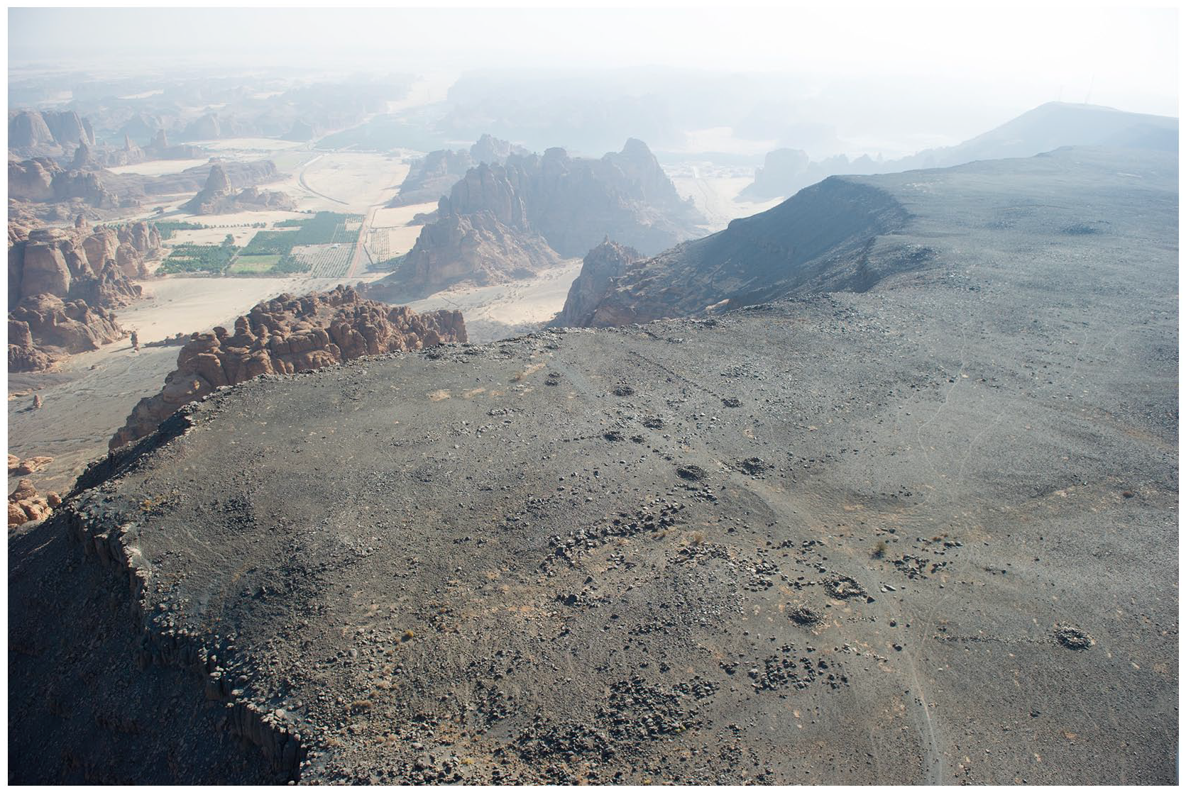
A funerary avenue with ‘cairn-tailed’ pendants and burial cairns (IDIHA-0004798). Here, the avenue descends 500 m from the Harrat ‘Uwayrid towards Saq, a spring near AlUla.
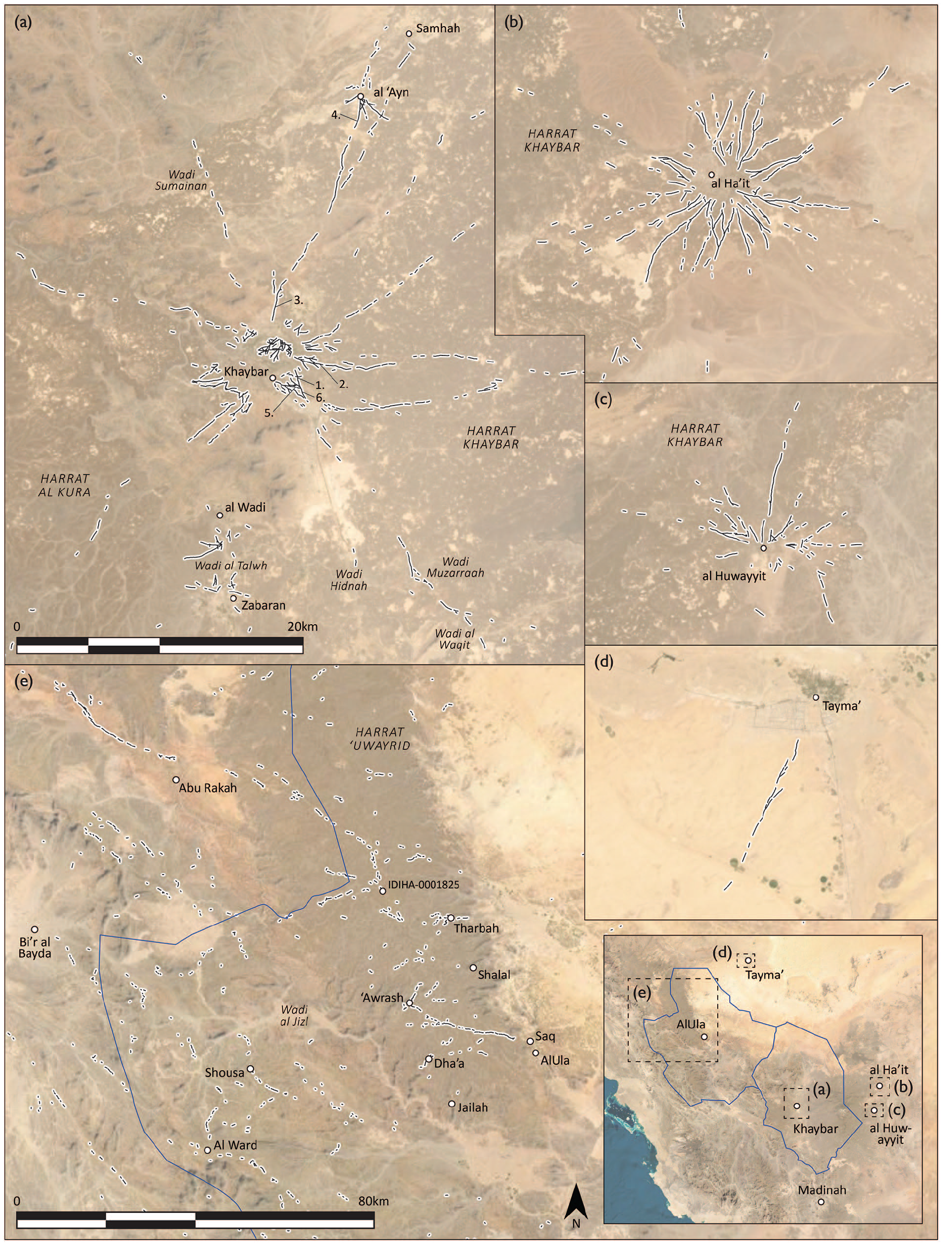
Details of selected funerary avenue concentrations identified in north-west Arabia, including those located near the oases of Khaybar (a), al Ha’it (b), al Huwayyit (c) and Tayma’ (d), and those located west of AlUla (e). The numbered avenue segments in (a) are described in Table 2 and below. N.B. (a)–(d) use the same scale.
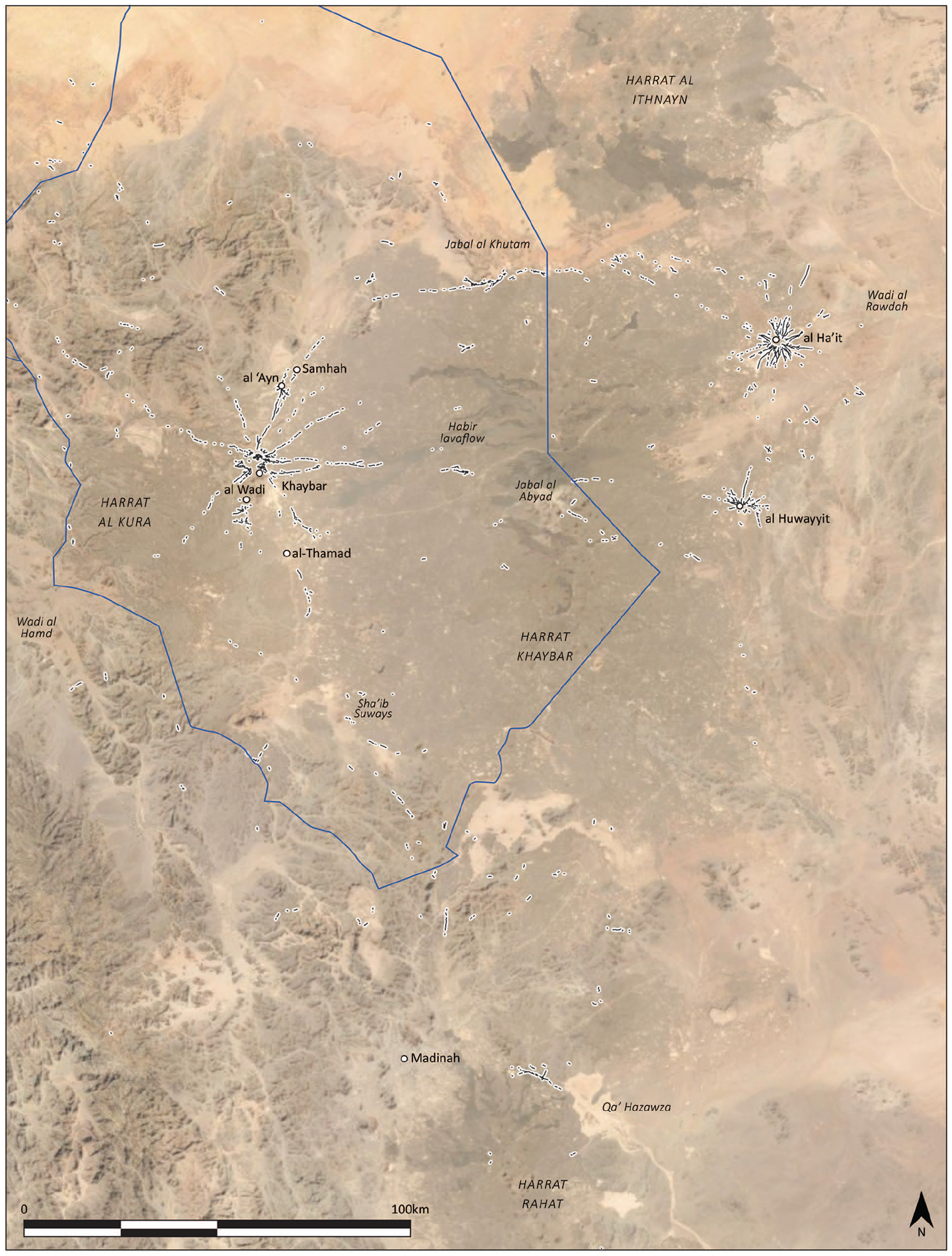
Funerary avenue segments identified in the Harrat Khaybar and environs, with Khaybar County (blue outline).
Not all identified funerary avenues link major water sources. Many avenues radiating from the large Harrat Khaybar oases instead ‘fade’ into surrounding landscapes (both by clarity of the pathway and density of associated monuments; see Figure 5a–c). Others head towards enormous regional wadi systems (e.g. the Wadi al Hamd southwest of Khaybar and Wadi al Rawdah east of al Ha’it; Figure 6). Avenues in the Hijaz Mountains west of AlUla lead great distances through networks of valleys (Figure 2), but known springs are integrated into only a few of these routes (e.g. Shousa and al Ward; see Figure 5 for locations). It remains difficult to posit start or end points for many sparser avenue segments, such as those identified on the Harrat Lunayyir (Figure 2).
Pendant temporality and regionality
As the most abundant and distinctive monument type constituting funerary avenues, pendant dating is of key importance in contextualising these ancient routeways. The excavation and radiometric dating of human remains within pendant burials suggest that they were in use for many millennia. Currently, the earliest such burials have been recorded at Jebel Jidran in Yemen. Two excavated pendants here, T.102 and T.105, yielded human remains dated to the early to mid-third millennium BCE (2884–2599 cal. BC and 2903–2675 cal. BC, respectively; Braemer et al., 2001: Tableau 7). Pendant burials in the Jebel Qurma region of Jordan have yielded later dates ranging from the third to second Centuries BCE to the third Century CE (Akkermans, 2019: 423–425; Akkermans and Brüning, 2017: 137; Akkermans et al., 2020: Figures 7 and 8). In spite of their abundance in north-west Arabia, few pendant burials here have yet been radiometrically dated. On the basis of surface finds and associated structures, Parr et al. (1978: 37, 40) and Al-Saud and Khan (2006: 52) hypothesise that the structures could date from the Chalcolithic through to Bronze and Iron Ages. Human remains recently recovered from pendants in AlUla and Khaybar counties have been dated from ~2600 to 2000 cal. BC, as well as to discrete periods within the first millennia BCE and CE (Kennedy et al., 2021: Figure 6, Table 1; unpublished 14C determinations). In our study areas, this evidence points to a major phase of pendant construction and use during the mid-to-late third millennium BCE, with monuments frequently reused for ad hoc burials in later periods (Kennedy et al., 2021). Indeed, pendants’ visibility in the landscape would have made them an obvious target for reuse, as well as looting and structural robbing (see below; cf. Akkermans, 2019: 427; Braemer et al., 2001: 41; Crassard et al., 2010).
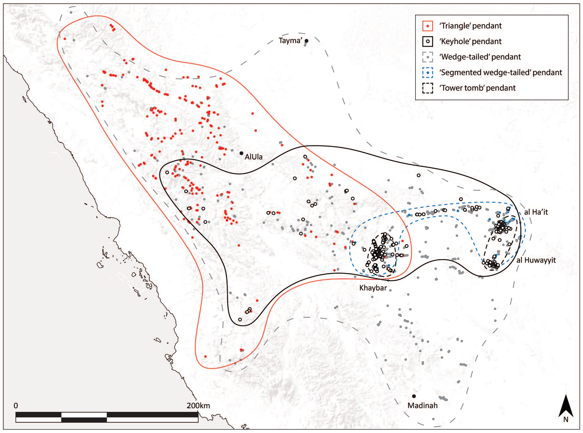
Approximate distribution (lines) of selected pendant types constituting identifiable avenue segments (dots). For clarity, no dots are shown for ‘tower tomb’ types, which were recorded only around Khaybar, al Ha’it and al Huwayyit oases. N.B. pendants of the same types not constituting avenues may be present outside marked areas.
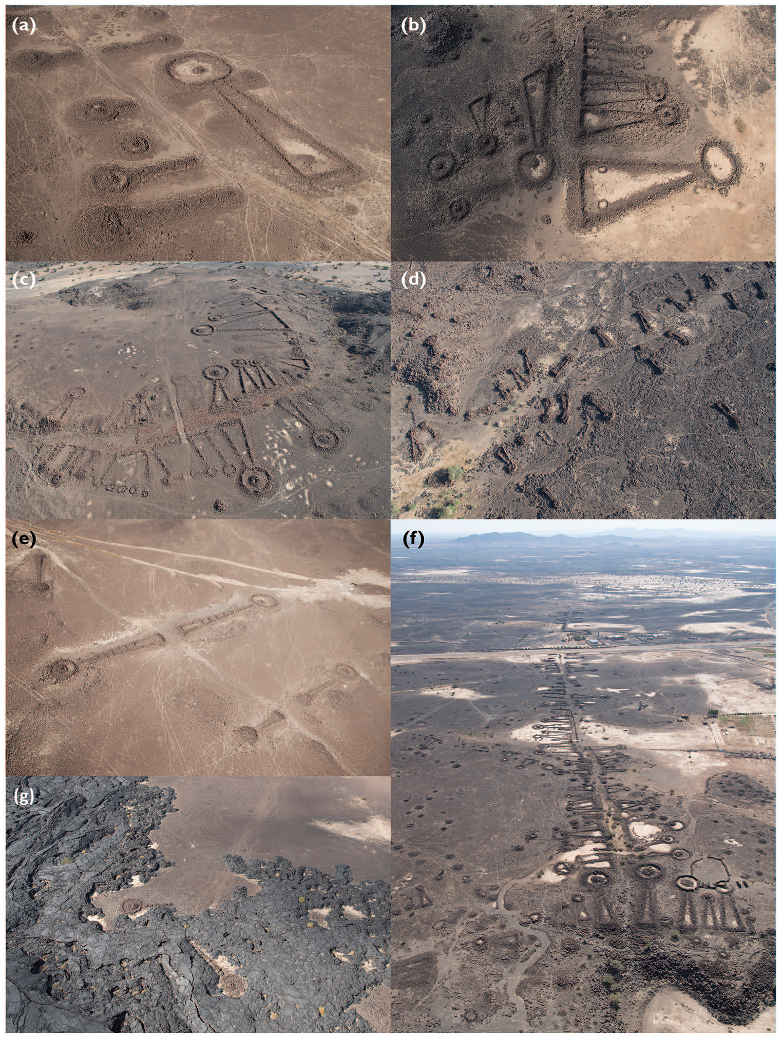
(a) ‘Keyhole’ pendant built over ‘wedge-tailed’ pendants near al Ha’it Oasis. (b) A ‘cascading’ cluster of pendants near al Ha’it Oasis. (c) Large pendants and red rock ‘pavement’ by the start of a funerary avenue near al Wadi (IDIHA-0030546). (d) A funerary avenue comprising ‘tower tomb’ pendants (IDIHA-0029427) in Khaybar Oasis. N.B. similar pendant size. (e) Facing pendants (including two ‘segmented wedge-tailed’ types to left) near al Ha’it Oasis. (f) Part of the ‘keyhole’ pendant-dominated funerary avenue linking al ‘Ayn (shown here) and Khaybar oases (IDIHA-0030741). This is the densest known avenue segment. N.B. ‘gateway’ of large pendants at the avenue start (foreground). (g) Funerary avenue with pathway (visible top right) and pendants (IDIHA-0031732) partially overlaid by the Habir lavaflow.
Number of pendants of selected types overlaying (columns) or overlaid by (rows) examples of the same types. Examples are drawn from both avenue and non-avenue sites subjected to detailed aerial or ground survey.
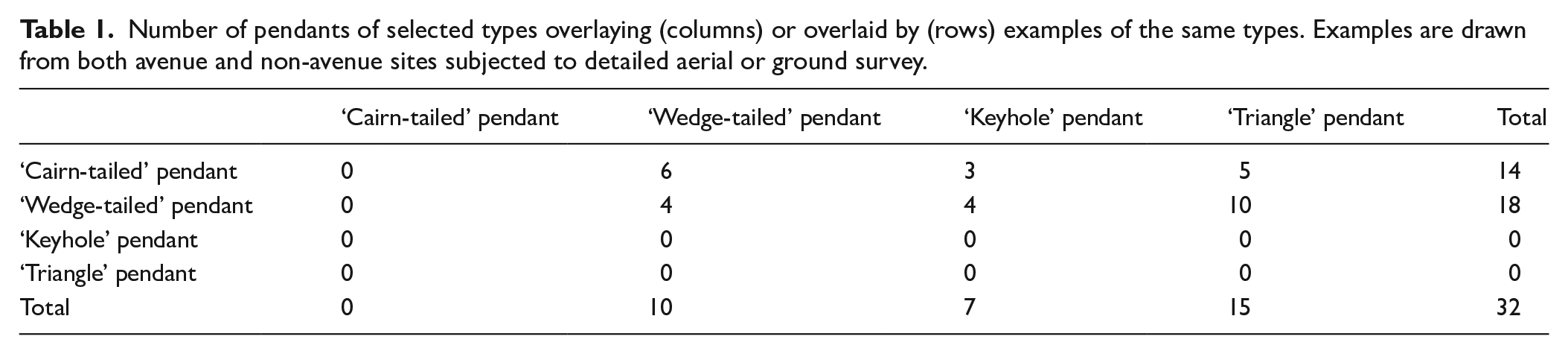
The apparent commonality of such reuse hampers attempts to date the original construction of pendants and specific pendant types according to their primary inhumations. There is, however, evidence within our study areas for temporal variation in certain morphologies. Occasionally, pendants were built upon or next to pre-existing examples, with superimposition or stone robbing indicating relative age. We surveyed thirty-two examples in which the constituent morphologies of both structures were clear (Table 1). ‘Cairn-tailed’ pendants (Figure 3l) are overlaid by all other forms and overlay no others; these are therefore likely to be the earliest type. ‘Wedge-tailed’ pendants (Figure 3a–b) overlay only ‘cairn-tailed’ types and other ‘wedge-tails’, and were thus probably built later. More recent still are ‘keyhole’ (Figure 3f–i) and ‘triangle’ pendants (Figure 3j–k), which overlay ‘wedge-tailed’ pendants but not vice versa. No known ‘keyhole’ or ‘triangle’ pendant overlays an example of the other. These types, which share partially overlapping ranges (Figure 7), may thus be contemporaneous. As yet, no clear examples of ‘segmented wedge-tailed’, ‘block cairn-tailed’ or ‘tower tomb’ pendants have been recorded in such a relationship, but there are strong indications that the latter also post-date ‘wedge-tailed’ types (see below).
A preliminary distribution analysis of pendant types was undertaken, based on the subset of these monuments that constitute funerary avenues. 3 Only types that could be differentiated in satellite imagery were assessed, to allow for the consistent investigation of avenue segments regardless of ground or aerial survey status. The presence of these types was tabulated for each defined avenue segment and the results mapped (Figure 7). Unclear examples were excluded.
This survey indicates a number of regional trends. Some pendants, such as ‘tower tomb’ types (Figure 3d and e), were recorded only close to the Harrat Khaybar oases (Figure 7). Distinctive ‘segmented wedge-tailed’ pendants (Figures 3c and 8e) were also recorded around these oases and, additionally, constituting several avenues linking Khaybar and al Ha’it (Figure 7). ‘Keyhole’ pendants are common around all Harrat Khaybar oases and are present (albeit rarely) as part of funerary avenues linking Khaybar and AlUla, and in isolated cases to the west (Figure 7). They do not constitute any identified avenues north of AlUla. ‘Triangle’ pendants commonly form part of avenues around AlUla and mountainous regions to the west, but only rarely those close to Khaybar (Figure 7). In contrast, ‘wedge-tailed’ pendants constitute avenues across the region (Figure 7).
Monument arrangement and orientation
The vast majority of pendants forming part of funerary avenues are oriented perpendicular to the path, regardless of its bearing (e.g. Figure 8c). Rarely, and with no discernible relationship to size or morphology, pendants are oriented obliquely. Regardless, the tail is almost always situated closer to the pathway than the head. This suggests that pendants were intended to ‘face’ the path so that the viewer’s eye would be guided from the tail towards the burial monument beyond. A small minority of pendants sit parallel to the path (e.g. Figure 8a). As these are often particularly large, this positioning may have been utilised to avoid the burial monument being located too far from its observers.
Where multiple pendants are oriented to a path, none seems to have been built or extended such that it would obstruct the route. Indeed, where multiple pendants face each other across a pathway, the gap between them (usually ~4–10 m) is often consistent (e.g. Figure 8f). Most were thus probably constructed with respect to a pre-existing pathway. Once built, many pendants would have physically focussed movement to these paths. As most monuments could not be added to or lengthened once the tail and head were constructed, it follows that they were built with a final size and form in mind.
Pendants constituting avenues were, in common with those situated elsewhere, occasionally overbuilt by a new pendant or partially dismantled to supply stone for another adjacent (e.g. Figure 8a). This superimposition was clearly sometimes a conscious choice, as in areas with ample building space nearby.
Pendants of the same type often show distinctive clustering. Commonly, similarly-sized pairs face each other across an avenue (Figure 8e). Twin, parallel-oriented pendants also often flank a pathway, creating a visually impressive ‘gateway’ (Figure 8f). Similar foci are also created by groups of smaller, converging pendants. Most of these features face away from the nearest oasis, suggesting they were oriented for maximum visual impact to those entering from outside. Exceptions are located by avenue starting points within the oasis (e.g. Figure 8e), itself probably a significant locale (see below). Groups of three or more pendants were also frequently built side-by-side; these usually ‘cascade’ in decreasing size order (e.g. Figure 8b). ‘Compound’ pendants, a form in which multiple (two to eight) examples share common walls (e.g. Figure 3i), are seemingly unique to the oases fringing the western Harrat Khaybar.
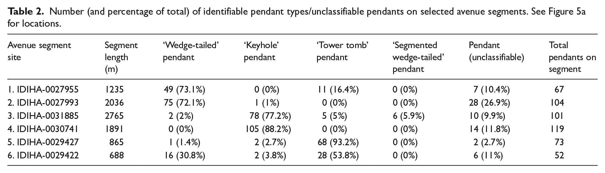
Many funerary avenues are primarily constituted by one pendant type. As exemplified by avenues radiating from Khaybar Oasis, those dominated by different types may be located in close proximity to each other (Table 2). On representative segments of two dense avenues heading south and east from this oasis, for example, 73.1% (IDIHA-0027955; Figure 1a) and 72.1% (IDIHA-0027993) of all constituent pendants (including those unable to be classified due to poor preservation or partial destruction) are ‘wedge-tailed’ types. A nearby segment of the avenue linking Khaybar and al ‘Ayn oases (IDIHA-0031885), on the other hand, displays 77.2% ‘keyhole’ types. The dense terminus of this avenue at al ‘Ayn (IDIHA-0030741; see Figure 8d) shows an even greater proportion of this type (88.2%). Meanwhile, another avenue originating in Khaybar Oasis (IDIHA-0029427; Figure 8d) comprises at least 93.1% ‘tower tomb’ types. Other avenues display more balanced amalgams of types. In one interesting example, the aforementioned ‘wedge-tailed’ (IDIHA-0027955) and ‘tower tomb’-dominated (IDIHA-0029427) avenue segments converge. Beyond this point, the resulting avenue (IDIHA-0029422) exhibits significant proportions of both types (30.8% and 53.8% respectively). No pendant on this segment overlays another, but the overall preservation of the ‘tower tomb’ types is significantly better. These were therefore probably built later (cf. Table 1), infilling gaps between the earlier, ‘wedge-tailed’ structures.
Number (and percentage of total) of identifiable pendant types/unclassifiable pendants on selected avenue segments. See Figure 5a for locations.
With few exceptions, funerary avenues display far lower monument densities away from major perennial water sources. Here, structures are often situated in prominent locales, such as mountain passes or valley entrances. In the Harrat Khaybar, avenue monument density often increases near large qa’ (mudflats formed by seasonal playa lakes) and wadis.
Avenue pathways
In our study region, the appearance and visibility of pathways varies according to local bedrock geology and sedimentary regimes. Those formed over weathered Palaeozoic sandstone plateaux (e.g. Figure 1b), or over the rocky hillslopes and alluvial fans characteristic of Precambrian Arabian Shield geology, usually appear lighter due to the incidental displacement of darker stones, the accumulation of pale sediment in eroded pathways and, on sandstone, the wearing away of black desert varnish to reveal the pale rock beneath. Pathways are also clear over the lavafields (e.g. Figure 8g), which are generally characterised by dense carpets of basalt overlaying and interspersed by pale loess. Here, stones have often been polished and pushed flat by repeated foot and hoof wear. Where routes traverse wadis, qa’ and other dynamic landforms, pathways may be difficult or impossible to identify due to erosion or sedimentation.
The meandering tracks that commonly constitute funerary avenues over all types of terrain (e.g. Figures 1b and 8a) are characteristic of animal movement (Huigens, 2018). There is usually no evidence for anthropogenic stone clearance. The overwhelming impression is that avenue pathways were not intentionally constructed, but rather formed over time by cumulative use. Around al ‘Ayn and al Wadi, however, short lengths of two avenue paths were either wholly surfaced or scattered with a distinctive red rock (Figure 8c). These occur near the beginning of the avenues, after they ascend from the oasis floor onto surrounding lavafield plateaux. Both stretches are associated with particularly large pendants, suggesting an elaboration of the area first encountered by anyone leaving the oasis.
It is usually impossible to date the origin of these pathways, or the longevity of their use. However, it is likely that many pendant-dominated funerary avenues constituted important routes before and/or after these phases of monumental construction. On the Harrat ‘Uwayrid, for example, several avenues converge upon and bisect IDIHA-0001825, a large site exhibiting multiple sixth millennium BCE ‘standing stone circle’ structures, a fifth to fourth millennia BCE communal burial, and numerous other funerary monuments including undated but presumably third millennium BCE pendants (Thomas et al., 2021a, in press; Figure 5e). This site was clearly an important and long-term focus of human activity, and the pathways leading to this site probably formed well before flanking funerary monuments were built. On this harrah, off-road tracks used by modern pastoralists also frequently follow the same routes as funerary avenues, a factor of the most direct route between water sources of continued importance. Between AlUla and Khaybar, clusters of Neolithic mustatils (Thomas et al., 2021b) flank the same valleys traversed by funerary avenues, suggesting a similar orientation to ancient thoroughfares. In one interesting case, a major avenue from Khaybar to al Ha’it has evidently been decommissioned by the undated ‘historic’ Habir lavaflow (Roobol and Camp, 1991b; Figures 6, 7 and 8g). The avenue’s clear pathway must have formed prior to this event, rather than due to recent pastoralist activity.
Meanwhile, for every identified funerary avenue across our study region, there are countless similar pathways with no obviously associated funerary monuments (and indeed many thousands of funerary monuments with no identifiable adjacent pathway). The use of these paths during the same timeframe should not be discounted.
Discussion
The most striking features of these funerary avenues are their presence over vast areas of north-west Arabia, their connections to (and between) perennial water sources, and the remarkable numbers of funerary monuments built around many oases – particularly those fringing the Harrat Khaybar. These features are likely the outcome of specific mobility, subsistence and settlement strategies, mediated through the opportunities and limitations of prevailing environmental conditions, and underpinned by complex sociocultural, technological and economic factors (e.g. Drechsler, 2009; Petraglia et al., 2020; Preston et al., 2012).
Environment, pastoral mobility and oasis settlement
Only limited palaeoenvironmental data are currently available for north-west Arabia, with sources particularly sparse for periods post ~3000 BCE (Engel et al., 2012; Gebel, 2013; Petraglia et al., 2020). Evidence for regional environmental trends and associated cultural responses throughout the Early to Middle Holocene nevertheless provides essential context to the ‘avenue’ phenomenon.
Following the phases of increased rainfall that characterised the Holocene Humid Period (HHP) in the Arabian Peninsula (~8000–4000 BCE), the region’s current, generally arid, conditions began to be established (Engel et al., 2012; Petraglia et al., 2020; Preston and Parker, 2013). Significantly, regional palaeoclimatic proxies indicate considerable fluctuations in post-HHP rainfall. Most relevant to this study is the period of increased rainfall evidenced during the early to mid-third millennium BCE, culminating in a major drying event around 2200 BCE/4.2k cal. BP (Bar-Matthews and Ayalon, 2011; Parker et al., 2006), at the Middle to Late-Holocene transition. This event was extremely widespread (cf. Staubwasser and Weiss, 2006, with references), but the environmental implications for north-west Arabia are currently unclear.
The limiting effects of post-HHP aridification appear to have led Neolithic groups in north-west Arabia to develop mobility and subsistence strategies capable of exploiting areas of seasonal or perennial water availability (Petraglia et al., 2020: 8265–8267; Scerri et al., 2018: 1190–1191). Hydrological structures such as wells were seemingly built here by pastoralists as early as the fifth millennium BCE (Gebel, 2013). Yet aridification trends in the two millennia following the HHP coincide with the regionally variable intensification of water management techniques, horticulture and sedentary occupation in locales with enhanced water availability (Dinies et al., 2016; Gebel, 2013, 2020; Hüneburg et al., 2019; Petraglia et al., 2020: 8268), supported or supplemented by pastoralism (Gebel, 2013: 124).
With few exceptions, our understanding of Middle Holocene lifeways in north-west Arabia is currently limited (Magee, 2014: 144–151). Yet funerary avenues provide important preliminary insights into the mobility and subsistence strategies of those who built them. In particular, the abundance of avenue-constituting funerary monuments near perennial water sources points to a significant focus of mid-to-late third millennium BCE human activity at these locations, potentially including permanent settlement (see below; cf. Cleuziou, 2002: 22). Meanwhile, the consistency of pendant typologies recorded around these oases and in the wider landscape strongly suggests that they were built by the same populations. This indicates that the people utilising oases during ‘avenue’ timeframes were also highly active in their hinterlands.
Funerary avenues provide evidence for at least some of the movements undertaken by their monuments’ builders in and out of oases and across the wider landscape. Of the former, the lack of apparent destination and ‘fading’ of many avenues, especially those radiating from the Harrat Khaybar oases, is particularly noteworthy. These factors suggest that paths formed as people and animals left oases at established points and then dispersed across adjacent hinterland landscapes, before returning in the same manner (see Ur, 2009 for a similar interpretation of pathways radiating from settlements in the northern Fertile Crescent).
Assuming periodic rainfall during periods of avenue construction (perhaps including winter rainfall regimes similar to the present day), many of these landscapes would have temporarily yielded wild forages and surface water features in the form of playa lakes and standing pools in rocky wadi beds, making them suitable for pastoral exploitation. 4 Of the thousands of ancient ‘camps’ located in our study areas (characterised by drystone animal enclosures, possible domestic structures and cleared areas), 5 many are clustered around such hydrological features (for comparable distribution patterns in the Harrat ash-Shaam see Betts, 1992; Meister et al., 2019). The temporal dimensions of camps in the region are currently unclear, but increased densities of pendants around many qa’ and standing pools indicates activity in these environments during ‘avenue’ timeframes. Large wadi systems, towards which some avenues appear to lead, would have also provided good pasturing opportunities.
As such, it seems likely that ‘avenue’ populations (or some members thereof) periodically moved their herds into surrounding landscapes when forage and surface water were in relative abundance, before returning to permanent water sources as hinterland resources dwindled. While such analogies must be treated with caution due to palaeoenvironmental uncertainties and the potential diversity of pastoralist lifeways (Khazanov, 2009: 122), the efficacy of such transhumance is underscored by its prevalence in north-west Arabia and the Levant more recently, as in the ‘east-west’ movement of Bedouin in Syria and Jordan to and from seasonal pastures (Bahhady, 1981; Roe, 2000), patterns also evidenced in Safaitic inscriptions (MacDonald, 1992). If such transhumance occurred during ‘avenue’ timeframes (whether on a seasonal or longer-term basis), we must consider how herds were sustained in and around oases during dry periods, with issues of foddering and competition in the growing and/or supply of plants for human and animal consumption at the fore.
‘Fading’ avenues are consistent with the relatively short-range dispersal of oasis-focussed populations and their herds into surrounding pastures. Other subsistence-related motivations for accessing these hinterlands could have ranged from collecting wild plant resources (e.g. firewood) to hunting, including the use of kite animal traps common in surrounding areas (Kennedy et al., 2015; for stratigraphic evidence that kite construction spanned pendant timeframes see Groucutt and Carleton, 2021). However, such movement cannot account for evidence of broader-scale avenue linkages between many water sources. These routes could indicate longer-range mobile pastoralism, as in Tunisia (where some groups move hundreds of kilometres from the southern deserts and plains to the northern mountains; Zogib, 2014: 36–44) or, until recently, north-west Arabia and the Levant (where Bedouin would move from Saudi Arabia to Syria and Iraq in search of more reliable pastures during times of drought; Gardner, 2003: 270). Indeed, by following only the networks of identified funerary avenues, it would be possible to traverse some 530 km, from Shawaq in the north-west to Qa’ Hazawza, south-east of Madinah, via AlUla and Khaybar (Figure 2). Oases and springs may have served as ‘nodes’ of reliable water and forage during longer-range pastoralist movements (cf. Wilkinson et al., 2014: 84). Conversely, evidence for broadly regional pendant typologies in certain periods could suggest that much movement occurred within somewhat smaller ranges (Figure 7; see below for further discussion of this point).
Whilst evidence is currently scant, other social and economic motivations for this apparent inter-oasis connectivity demand consideration. Long-distance trade in the region is hypothesised to have started in later periods (Luciani, 2016: 28, with references), but not enough is currently known of mid-to-late third millennium BCE material culture here to discount movement for either exchange or raw materials sourcing (for relevant considerations elsewhere see Abu-Azizeh, 2013: 166–171; Fujii et al., 2018: 232; Müller-Neuhof, 2020: 157–158 for Jordan; De Maigret 2009: 340; Steimer-Herbet and Besse, 2020: 99 for Yemen; and Cleuziou, 2002: 25 for Oman). Several avenues converge near Jebel al Abyad, a source of obsidian (Grainger, 2007), although this may be incidental to its position on an apparent route between Khaybar and al Huwayyit (Figure 6). Furthermore, social linkages and meetings within or between wider ‘tribes’ (important, for example, in some modern Bedouin societies; Cole, 2003: 246) may well have precipitated movement into and between oases.
Pendants and other drystone burial monuments of the wider region have been generally interpreted as the work of a dominantly mobile pastoralist cultural complex during later prehistoric periods (e.g. Abu-Azizeh, 2013; Fujii, 2016: 130–131; Fujii et al., 2018: 231; Steimer-Herbet, 2011: 111–113). While much of the evidence presented above is in part consistent with pastoralist lifeways, the abundance of avenue-constituting funerary monuments within and around many oases prompts consideration of how responsible populations inhabited and utilised these locales. Of particular interest is the extent (if any) to which they developed permanent settlements, water management features and horticulture and, if so, the relative importance of pastoral and agricultural subsistence strategies over time (Gebel, 2013; Magee, 2014: 276). Alternatively, were these locales additionally or solely occupied by other, more sedentary populations and, if so, how did these groups interact? Khazanov provides a useful summary of the complexities inherent in such lines of enquiry, including the potential for highly dynamic relationships between more and less sedentary populations, for the same populations to dramatically shift their lifeways and subsistence strategies over time, and for mobile groups to constitute discrete parts of agropastoral societies (2009, with references). 6 Assuming that pendants in Jordan and Syria date to a similar period, similar questions may be posed of their builders’ links to the Early Bronze Age societies of the adjacent southern Levant (cf. Abu-Azizeh, 2013: 150–151).
Tayma’, apparently situated at the northern limits of the ‘avenue’ phenomenon, provides a tantalising perspective. By the mid-third millennium BCE, this oasis was already substantially walled (Hausleiter, 2018: 384–386, Figure 12) and likely hosted a permanent population (Hausleiter and Eichmann, 2018: 24–25). On the basis of comparison between distinctive late third–early second millennium BCE tombs in necropoleis south of Tayma’ and pendants observed in its desert hinterlands, Hausleiter and Zur (2016) suggest that the site may have served as an interface between discrete pastoralist burial traditions and those of its more sedentary Early Bronze Age populations (pp. 165–166). However, these Bronze Age tombs are seemingly several centuries later than pendants dated in Khaybar, and the site’s pendant-lined funerary avenues may therefore pre-date them. Clearly, further data relating to this stage of Tayma’s development is required to understand the interaction of ‘avenue’ populations and the site’s more sedentary occupants (if indeed these constituted different groups), and these people’s potential contribution towards this settlement’s development and apparent linkages to the Bronze Age Levant (Hausleiter, 2011).
The settlement histories of most other avenue-associated oases during and preceding the third millennium BCE are currently largely unknown, although this situation is anticipated to change as intensive ongoing fieldwork yields results. 7 In the interim, it is noteworthy that many were, like Tayma’, wholly or partially enclosed by monumental, probably pre-Islamic perimeter walls (Charloux et al., 2021a). 8 At Khaybar, al Ha’it, al Huwayyit, al ‘Ayn and Wadi al Waqit oases, where these walls intersect with funerary avenues, all overlay avenue monuments and must therefore post-date them. These walls are hypothesised to have been built to protect their more settled inhabitants from incursions by outsiders, to mitigate environmental threats, and to invoke territorial claims more generally, amongst other complex factors (Charloux et al., 2021a). The monumental funerary evidence presented above currently argues against any dichotomous relationships between notional ‘insiders’ and ‘outsiders’ during preceding ‘avenue’ timeframes. Rather, these people appear to be one and the same, notwithstanding the potential for sociocultural or territorial subdivisions within wider ‘avenue’ populations (see below), or for complex shifts in subsistence and mobility strategies over time.
Considering the possible effects of environmental change on these populations raises important questions but no firm answers. For example, to what extent were the pastoralist lifeways suggested by these avenues made possible by regional climatic amelioration evidenced during the early to mid-third millennium BCE? Did drought associated with the 4.2k event curtail mobile pastoral activity and force these populations into more sedentary, oasis-centred settlement and agricultural subsistence strategies? More comprehensive dating of the development and temporal dimensions of the ‘avenue’ phenomenon and, ideally, the development of more localised palaeoclimatic proxies are required to address these issues.
Prominence, territoriality and sociocultural implications
Why were funerary monuments so frequently built alongside and oriented towards pathways in this region of north-west Arabia? One major motivation is likely to have been visual prominence, a concept common to pendants (and many of the region’s other prehistoric funerary structures) across their range. These are frequently situated on high ground, where they present distinctive profiles identifiable from long distances (e.g. Akkermans and Brüning, 2017: 138–139; Banks et al., 2017: 16; Cleuziou, 2002: 27; De Maigret, 2009: 337; Fujii et al., 2018: 230; Philip, 2008: 210; Steimer-Herbet and Besse, 2020: 100–101). Situating monuments alongside well-trafficked routeways would have had a similar impact. A preoccupation with the visual experience of avenue monuments is underscored by the evident importance of sightlines in pendants’ orientation to viewers (above).
Following this logic, one explanation for the apparent absence or indistinctness of funerary avenues in other areas of pendants’ overall range is that ancient routeways were too diffuse here to constitute suitably well-trafficked (and thus preferentially visible) locales for monument construction. Furthermore, if environmental conditions allowed for the wider inhabitation of certain landscapes, then permanent water sources need not have become such foci of movement (as they evidently did within our study areas). In such circumstances, prominent landforms may have been preferred. It is also possible that monuments were built alongside routeways elsewhere, but these are insufficiently dense to allow the recognition of associated routes (cf. Fujii, 2016: 129). Alternatively, clear pathways may have never formed or have since been erased by landscape change. For example, whilst pathways are generally indistinct, De Maigret (1996: 335, 2009: 335–340, Figure 74) has identified chains of turret tombs (many ‘tailed’ and therefore pendants) situated alongside and oriented parallel to long-distance routeways between cities of the first millennium BCE in Yemen. Based on the 14C dating of human remains in several pendants at al-Maẖdarah, De Maigret (2009: 327–335) interprets these as contemporaneous trade routes, whilst acknowledging that the structure types could have been built as early as the third to second millennium BCE south Arabian Bronze Age (cf. Cleuziou, 2002: 28–29). If further analysis confirms such dating, these features would provide an approximately contemporaneous parallel to the north-west Arabian funerary avenues discussed here, potentially expanding the range of this phenomenon over 1000 km further south.
Pending corroborative data relating to the demographics of their original inhabitant(s) and possible material evidence of status, funerary avenue-associated burial monuments provide preliminary insights into the social structures of the populations that built them. Due primarily to the small size of the burial chambers, it is plausible that these structures were generally built for one person or, at most, a small group of individuals (Kennedy et al., 2021). If correct, certain variations between these monuments have a number of interesting implications. Most avenue-constituting pendant types, for example, vary enormously in size. Furthermore, the largest are frequently located in the most prominent locations, especially at avenue start points (e.g. Figure 8c and f). The ability to mobilise the labour necessary to build these enormous monuments, and to preferentially occupy such positions, suggests some form of social hierarchy within the populations that built them (Steimer-Herbet and Besse, 2020: 114–116; cf. Magee, 2014: 11–12). However, some varieties of pendant (e.g. ‘tower tomb’ types) are highly consistent in size and form across whole avenues (e.g. Figure 8d), indicating a more equitable approach to memorialisation and hinting at significant social differences amongst the populations that built them.
The close spatial association of many monuments constituting funerary avenues could indicate the actual or intended materialisation of kinship relationships in death. Of particular note are ‘compound’ and ‘cascading’ pendants, in which a larger monument is usually adjoined by smaller ones, perhaps indicative of their intended use by a high-status individual and multiple descendants or wider kin. Interestingly, such monuments frequently display few or no funerary components, suggesting a pre-planned schema for existing or notional groups that was only incompletely realised (for example, if individuals’ own memorial priorities changed over their life). Meanwhile, the ‘twinning’ of pendants could indicate a desire to link two closely related individuals in death (e.g. spouses or a parent and child). Such pendants are generally of a similar size, suggesting the desired projection of equivalent status.
Relative chronological evidence indicates temporal change in some pendant morphologies (Table 1). However, stylistic evolution cannot wholly account for the regional clustering displayed by many types (Figure 7), including relatively late examples (e.g. distinctive ‘keyhole’, ‘triangle’ and ‘tower tomb’ pendants). Assuming contemporaneity (above), the overlapping ranges of these types implies that populations would have been aware of such morphological differences. Reaching well beyond immediate kinship connections, this patterning could suggest that some forms were used to actively materialise broader social identities and, perhaps, to serve as markers of associated territories. Pendants are particularly amenable to such a reading due to their morphological variability and prominence in the landscape (for similar interpretations of prehistoric burial monuments regionally see Abu-Azizeh et al., 2014: 182–183; Bradbury and Philip, 2011: 176–177; Cleuziou, 2002; Lönnqvist, 2010: 166; McCorriston, 2011: 116–117, with references). Meanwhile, pre-existing monuments would have remained highly visible in the landscape, potentially opening themselves to symbolic manipulation. As yet, most recorded examples of pendant overbuilding in our study areas occur between certain types (Table 1). One explanation is that older forms were understood to belong to unrelated ‘others’, and were thus available for expedient stone robbing. Alternatively, these monuments could have been overbuilt and/or partially dismantled as a symbolic means of wresting ownership from the land’s former occupants or, conversely, gaining legitimacy by creating a visible spatial connection with real or perceived ancestors (Hallote, 1995: 107–111; see Gernez and Giraud, 2019: 137 for comparable interpretations of palimpsest funerary monuments in Bronze Age Oman).
If some pendant morphologies were indeed understood to represent social or other identities, the alignment to discrete avenues of numerous pendants of the same type (Table 2) could have resulted from a desire amongst the perceived members of such groups to be buried in close proximity to each other, perhaps as a means of encouraging social cohesion (e.g. Abu-Azizeh, et al. 2014: 183). These near-homogeneous avenues could therefore have marked routes between oases and specific groups’ pastoral territories (cf. Cleuziou, 2002: 22, 25; Wilkinson et al., 2014). By marking the main routes into oases, it is also plausible that some avenues signalled territorial claims over these locales’ important resources. Given likely temporal variation in other pendant types (e.g. earlier ‘wedge-tailed’ and later ‘keyhole’ types), the routes marked by such avenues may have been primarily active during certain timeframes, whilst those exhibiting combinations of types continued in use over longer periods. If so, better absolute chronological control over distinctive pendant morphologies may allow for the temporal reconstruction of the use of such routes, as well as the notional territories posited above.
Conclusions and future research directions
Funerary avenues provide an emerging source for reconstructing important aspects of Middle Holocene mobility and subsistence strategies across large parts of north-west Arabia, as well as the social structures and group identities of those who built them.
Many of these features suggest the cyclical movement of at least some members of associated populations into and out of locales of perennial water availability, with hinterland pastoralism particularly strongly implicated. Meanwhile, intensive funerary activity in these oases implies long-term settlement by the same populations, potentially indicating the enactment of mixed agropastoral subsistence strategies in these locales as early as the mid-third millennium BCE. Other avenues, especially those connecting major oases, may have been associated with social and economic factors beyond those related to pastoralism alone, but these are currently obscure. Regardless of the surely complex dynamics that motivated ancient populations to move across these landscapes, funerary avenues clearly transcended any isolated mortuary function, and were instead deeply integrated into the lifeways of those who built and used them, as well as those who continued to encounter them (and at times reuse their monuments) in successive millennia.
Much work remains to be done to elucidate these preliminary hypotheses. The nature of these oases’ Middle to Late-Holocene inhabitation is an obvious priority for further investigation. It is simultaneously important to investigate ‘camp’ sites in non-oasis hinterlands, in order to identify the timing and nature of pastoralist activity indicated by many avenues (for likely challenges see Abu-Azizeh, 2013). The continued excavation and analysis of human remains within these monuments is also essential. Primary inhumations, where identifiable and suitably preserved, may reveal the demographics of those for whom avenue monuments were originally constructed, allowing better reconstructions of these societies and their funerary practices. Further radiometric dating is also required to delimit monuments’ original phases of construction and any reuse, potentially yielding temporally finer-grained assessments of group identity and territoriality, and better situating populations’ subsistence and mobility strategies within the context of regional environmental change. Meanwhile, DNA studies of interred individuals may allow for certain hypothesised genealogical links to be proved (e.g. Vai et al., 2020), whilst stable isotope analyses could reveal movements undertaken by these people (e.g. Gregoricka, 2013; Gregoricka et al., 2020), thus nuancing patterning visible in the spatial data. Given widespread secondary reuse and disturbance, extensive excavation is required to shorten the odds of yielding primary inhumations suitable for such analyses. Meanwhile, continued remote sensing and aerial photographic reconnaissance have an important role to play in recognising and spatialising these monuments’ potentially diagnostic morphological variations.
Within this context, it is vital to recognise the serious and ongoing damage and destruction of this region’s cultural heritage, including these funerary avenues, through widespread illicit excavation and massive land clearance for agricultural development. The ongoing, large-scale preservation efforts of the Saudi Arabian authorities are to be lauded, but urgent recording and protection of these exceptional cultural landscapes must remain high priorities.
Footnotes
Acknowledgements
We thank the Royal Commission for AlUla for its support, especially the Governor, His Highness Prince Badr bin Abdullah bin Mohammad bin Farhan Al Saud; the CEO, Amr AlMadani; and the Director of Archaeology and Cultural Heritage Research, Rebecca Foote. Thanks also to Munirah A Almushawh for insights into Khaybar County toponyms, and to AAKSAU/AAKSAK team members and the pilots and crew of Abu Dhabi Aviation and The Helicopter Company for their survey contributions. We acknowledge two anonymous reviewers for their constructive comments. Finally, we are very grateful to David L Kennedy for his comments on this paper, access to remote sensing data, and work in bringing these important features to wider attention.
Funding
The author(s) disclosed receipt of the following financial support for the research, authorship, and/or publication of this article: This work was supported by the Royal Commission for AlUla.