
Abstract
The Empordà plain attests to a remarkable mixture of Late-Holocene cultural exchanges and colonial processes. This includes the founding of Emporion, the earliest Greek colony in Iberia, and of the Roman city of Emporiae. This study aims at assessing landscape changes related to indigenous and colonial settlement in this unique scenario where the shaping of cultural landscapes occurred within a dynamic coastal ecosystem. We carried out a high-temporal resolution palaeoenvironmental study in Els Estanys, a palaeowetland located in the vicinity of Emporion-Emporiae. Palynological, sedimentological and geochemical indicators were coupled with available archaeological and archaeobotanical data-sets. Between 1100 and 800 cal BC, the settling of Urnfield Late Bronze societies resulted in the sustained clearance of woodlands and moderate agropastoral exploitation of coastal ranges. During this period, marine-influenced lagoonal areas were poorly exploited. During the Iron Age (800–450 cal BC), a threshold in the landscape construction of the area occurred with the first pastoral exploitation of lagoonal areas, intensified cereal cultivation, controlled burning, and enhanced deforestation following the settlement of Iberian groups. Greek colonisation (580–200 cal BC), did not trigger intensified farming exploitation or landscape clearance, nor did it imply the introduction of new land uses or crops in the hinterland. Exploitation of the latter continued relying on cereal cultivation and grazing, as before, suggesting the permanence of indigenous landscapes and practices in the hinterland. To the contrary, urban and periurban landscapes played a significant role in the construction of the colonial landscape with the introduction of olive groves likely as ornamental trees. Roman conquest and colonisation of the area constituted a new threshold in the occupation and management of the hinterland with (1) intensified rural settlement; (2) expansion of wet pastures and removal of littoral woodlands; (3) development of diversified cropping activities; and (4) development of mining and smelting activities.
Keywords
Introduction
Over millennia, the Mediterranean Sea has been the contact route and cradle of ancient civilisations. Long-term trading, migratory and colonial processes imply the exchange of people, goods and ideas throughout the Mediterranean coastal lands, and gave rise to a rich, hybrid cultural heritage integrating both indigenous and alien cultural traditions. This is widely evidenced in the archaeological record, particularly during the Iron Age and Antiquity, when Phoenician, Greek and Roman colonial processes intensified socio-cultural interactions across the Mediterranean, and resulted in significant socioeconomic changes that are reflected in the material culture, that is, development of urbanism, changes in architecture and ceramics, and intensified commerce and exchange of goods and food (Horden and Purcell, 2000; van Dommelen, 2005). Migratory and colonial encounters also imply the exchange and/or introduction of new land-uses, plants and land organisation systems. This can lead to significant and long-lasting environmental and landscape changes in coastal environments – deforestation, introduction of exotic plants and crops, erosion, silting up of wetlands – that can be traced back to the use of palaeoenvironmental techniques (e.g. Ejarque et al., 2015; Gauthier et al., 2010; Ledger et al., 2014; Nogué et al., 2021). Such landscape changes play an active role in the process of cultural engagement and land appropriation in new territories. Indeed, land exploitation, appropriation and related cultural landscapes are acknowledged as essential components in the formation of cultural identities in migratory and colonisation processes (Gosden, 2004). However, little is known of the coastal landscape and land-use changes following Mediterranean socio-cultural exchanges, particularly in the Western Mediterranean. This is mainly because of the difficulty of locating continuous organic-rich palaeoenvironmental records in littoral areas where coupled long-term climatic-environmental change and human exploitation have resulted in the contraction, silting up or loss of wetlands (Cataudella et al., 2015). This is the case for wetlands in the vicinity of many western Greco-Roman colonies (e.g. Massalia, Emporion, Barcino and Tarraco), whose immediate environment was in addition subject to significant urban development and/or agriculture exploitation during the historical period. Last but not least, most available palynological analyses along the Western Mediterranean coast are characterised by poor chronological control and/or coarse temporal resolution (>50/100 years between studied samples) for the Iron Age and Antiquity periods (e.g. Azuara et al., 2015; Burjachs et al., 2017; Court-Picon et al., 2010; Ejarque et al., 2016; Jiménez-Moreno et al., 2015; Parra, 2012; Riera-Mora and Esteban-Amat, 1994), which hampers detailed landscape reconstruction and correlation with archaeological data.
The Empordà plain, located in the North Eastern Iberian Peninsula, attests to a remarkable mixture of cultural exchanges and colonial processes during the Iron Age and Antiquity. Maritime contacts and exchange were particularly significant in this area, where littoral mountain ranges made terrestrial exchanges between the narrow littoral plain and inland areas difficult. During the Iron Age, Iberian populations established fruitful cultural and commercial relationships with many Mediterranean cultures, such as the Phoenicians, Greeks, and Romans, with some of these cultures ultimately establishing permanent colonial settlements within the plain. This is the case for the Greek Emporion and Roman Emporiae colonies, which were founded in the early sixth and first centuries BC, respectively (Castanyer et al., 2016), and which developed a network of rural sites and field system organisation in the coastal hinterland (Palet et al., 2021). This historical process happened within a highly dynamic littoral ecosystem subject to sea-level changes and fluvial flooding that contributed to the formation of beach-barriers and the in-filling of the plain (Montaner et al., 2014). With Emporion being the earliest colonial Greek settlement in Iberia and the gateway for the Roman conquest of Hispania this site presents a unique scenario for assessing landscape changes related to ancient peopling and colonisation in the Western Mediterranean, and the interaction of these cultural processes with changing coastal dynamics.
This manuscript describes a multi-proxy palaeoenvironmental study performed in the ‘Els Estanys’ palaeowetland. This is located in the immediate coastal hinterland of Emporion-Emporiae, and the recovered sedimentary record allows for high-temporal resolution palaeoenvironmental analysis from from 1500 cal BC to 600 cal AD. We studied a range of proxy indicators including pollen, non-pollen palynomorphs, charcoal, mineralogy and geochemistry, to reconstruct the wetland’s palaeoenvironmental dynamics and track changes in vegetation, land-uses and natural resource exploitation. This information is further coupled with available regional palaeoenvironmental and archaeological datasets to assess the relative influence of climate and anthropogenic forcing on coastal landscape change, and to better understand the influence of peopling and colonisation processes in the shaping of Western Mediterranean landscapes.
Site description and archaeological context
Geographic and geomorphological setting
The study area is located in the central part of the Empordà littoral plain, at the southern border of the Gulf of Roses, NE Catalonia (Figure 1a). This part of the Empordà alluvial plain was formed during the Holocene by the coalescence of alluvial deposits from the Fluvià and Ter rivers (Montaner et al., 2014), flowing respectively to the north and south of the study area (Figure 1a). The plain is limited to the west by Neogene alluvial fan deposits extending from foot slopes of the Segalar range (177 m a.s.l.; Figure 1b). To the south, the karstic Mesozoic Montgrí Massif (317 m a.s.l.) is the main relief within the littoral plain. Its northern low-elevation outcrops (<100 m a.s.l.) concentrated most of the archaeological settlement within the study area, including the Emporion-Emporiae colonies (Figure 1b). Palaeogeomorphological analyses have documented the presence of a palaeochannel-estuary of the Ter River to the west of the Empúries promontory, a channel that laterally migrated from west to east from ~8 ky cal BP until the 14th century AD (Montaner et al., 2014, Figure 1b). Shallow fresh-to-brackish water marshes formed in the flanks of this microtidal estuary (Figure 1b).
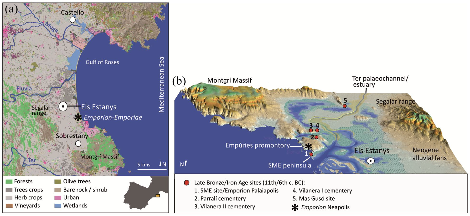
Maps showing the location of the study area. (a) land use map showing the location of the Empordà plain and Els Estanys palaeowetland in NE Catalonia. Other main pollen records mentioned in the text are also marked and (b) palaeogeomorphological reconstruction of the study area at ~3000 cal BP with Late Bronze Age-Iron Age archaeological sites (modified from Castanyer et al., 2016).
Our study was carried out in a palaeo-wetland (42°08′57.6″N, 3°05′02.6″E) located in the western flank of this estuary. It occupies a basin of ~70 ha, and is located ~3 km NW of the colony (Figure 1). The toponym of this area, ‘Els Estanys’, has been retained for the studied record. The palaeo-wetland lies 3.4 km west of the Mediterranean Sea, and the alluvial plain slope reaches c. 1‰. Several streams originating in the Neogene alluvial fans and a network of anthropogenic channels (Figure 1a) control the present-day hydrologic dynamics of the study area. The study area was largely drained for agricultural purposes during the mid-18th century (Romagosa Casals, 2009).
Climate and vegetation
The area has a Mediterranean climate with mild winters, warm dry summers and a mean annual rainfall of 710 mm. The mean temperature ranges from 9°C in winter to 23°C in summer (National Institute of Meteorology; Gesti, 2006). The zone is exposed to the Tramontane, dry and fresh NNW winds that blow during the winter months. Easterly gale-force Levantine winds also cause occasional coastal flooding and storm surges, with high-energy waves up to 1 m in height in this typically Mediterranean microtidal area with an average tidal range of 0.15 m.
The study area is largely occupied by irrigated croplands, while Aleppo pine (Pinus halepensis) woodlands, and to a lesser extent macchia communities with holm trees (Quercus ilex) and other thermomediterranean shrubs such as Pistacia lentiscus, Phillyrea angustifolia and Rosmarinus officinalis, grow in non-cultivated areas of the littoral ranges (Figure 1a). Marginal patches of riparian forests grow along the river banks of the Fluvià and Ter rivers, which are rather dominated by irrigated fruit crops or plantations of Populus spp. and Platanus spp. Freshwater marshes, streams and channels in the Empordà plain are dominated by helophytes such as bulrush (Typha spp.), sedges (Scirpus maritimus, Eleocharis spp., Carex spp.), the common reed (Phragmites australis), the fool’s-water-cress (Apium nodiflorum) or the reed canary grass (Phalaris arundinacea). Other common species are Alisma plantago-aquatica, Iris pseudacorus or Thalictrum morisonii (Gesti, 2006). Frequently flooded salt marshes are dominated by members of the Amaranthaceae (Salicornia spp., Suaeda spp., Arthrocnemum fruticosum), while other species such as sedges (Juncus ssp., Carex divisa), Spartina spp., Aeluropus spp., Limonium spp or Ruppia spp. develop in less frequently flooded salt marshes. Artemisia gallica and Limonium spp. are rich in dry sandy soils from poorly or occasionally flooded salt marshes (Gesti, 2006). Wet meadows are dominated by members of the Poaceae (e.g. Gaudinia fragilis, Poa trivialis, Hordeum secalinum). They are also rich in flax (Linum usitatissimum), Fabaceae (Trifolium spp., Lotus corniculatus, Lathyrus spp.), Asteraceae (Picris echioides, Aster squamatus), Cichorieae (e.g. Cichorium intybus, Sonchus asper), Rumex crispus and Plantago lanceolata. Common perennial plants growing on dunes and foredunes are members of the Poaceae, Crucianella maritima, Teucrium polium dunense, Apiaceae (Echinophora spinosa, Eryngium maritimum) and Ephedra distachya (Gesti, 2006).
Archaeological data and context
This study uses a variety of archaeological data to make crosschecks with the palaeoenvironmental dataset. This data includes published information from excavations and field surveys (e.g. Casas et al., 2010; Castanyer et al., 2016; Palet et al., 2021), as well as archaeological reports from recent diggings and field surveys (e.g. Castanyer et al., 2020). Detailed maps of settlement evolution and field organisation systems in the study area have been produced for Iron Age and Antiquity periods. These maps integrate available archaeological settlement distributions in the area with results obtained from high precision archaeomorphological analyses, field surveys and fieldwork, including analysis of lithostratigraphic profiles, radiocarbon dating and excavation of test pits on agrarian structures (Palet et al., 2014b, 2021).
Between the 11th and 9th century BC, late Bronze Age groups of the so-called ‘Urnfield culture’ intermittently occupied open-air sites in the littoral promontories, that is, the Sant Martí d’Empúries (SME) and Mas Gusó sites. These groups also constructed Urnfield cemeteries that were used and expanded until the early Iron Age (sixth century BC; Figure 1b) (Aquilué et al., 2012). Stable settlement began during the mid-seventh century BC, with the recording of permanent Iberian villages at the SME and Mas Gusó sites, and the beginning of commercial contact with Phoenicians, Etruscans and Greeks. This led to the foundation of the Greek colony of Emporion in 580–540 cal BC, which was a trading post founded by Phocaean groups during their expansion into the Western Mediterranean (Castanyer et al., 2016). According to Estrabon, the inhabitants called this newly founded post ‘Palaia Polis’ or ‘ancient city’ (Geog. III.4,8). The Palaia Polis is recorded archaeologically in the SME promontory, which at that time formed an isthmus/peninsula in front of the palaeocoast, and immediately overlaying the occupation levels of the Iberian Sant Martí d’Empúries (SME) village (Castanyer et al., 1999) (Figure 1b). In the mid-sixth century BC, a second larger colonial site was founded on the adjacent mainland coast (Figure 1b). This site, commonly designated in the archaeological literature as Neapolis or ‘new city’, coexisted with the Palaia Polis, and together they constituted the colony of Emporion. Emporion controlled maritime trading between NE Iberian groups and other Mediterranean cultures until the mid-second century BC (Castanyer et al., 2016). It became the gateway for the Roman conquest of Hispania, being the ally of Rome in 218 BC during the second Punic War, and the landing port for Roman troops in the conquest of the Iberian Peninsula during the first half of the second century BC. Soon afterwards, at the beginning of the first century BC, a Roman city was built immediately to the W of the Neapolis. Emporion and the new Roman nuclei merged together to form the Roman municipium of Emporiae (Castanyer et al., 2016). The city flourished economically, controlling and exploiting its hinterland through a network of villas, rural sites and field systems (Palet et al., 2021). However, from the first century AD, the economic importance of Emporiae progressively faded in favour of other nearby Roman cities. This led to the abandonment of large areas of Emporiae and its related rural sites and villas during the late third century AD. During the late Roman and Visigoth periods (fourth to seventh century AD), settlement was concentrated in the ancient Palaia Polis and in Santa Margarida, a Christian ecclesiastic nucleus founded in the westernmost part of the Empúries promontory. In parallel, other urban areas of Emporiae were used as a cemetery, and new rural sites appeared in the hinterland (Nolla et al., 2014).
Materials and methods
Coring and sampling
In 2014, a 300-cm depth core (Cl-1) was obtained in the Els Estanys wetland using a 50 cm × 5 cm ‘Russian’ corer. The core was obtained in a 75-cm deep drainage channel whose bottom was located at 255 m a.s.l. One-cm-thick subsamples were taken for pollen, non-pollen palynomorphs, macro remains, sedimentological and geochemical analyses at intervals of 10, 5 and 2 cm in the 210-cm-deep basal organic-rich muddy unit expanding below 90 cm in depth. The uppermost 90 cm of the record were rejected for this study because of poor organic preservation.
Additional samples for pollen analyses were collected in a drainage channel excavated in the NW limit of Emporion Neapolis in 2018. The archaeological infilling of the channel was dated to the second half of the sixth century BC, the foundational phase of Neapolis (Castanyer et al., 2020). The palynological study of these samples will furnish specific palaeoenvironmental information on the immediate periurban landscape of the Greek colony, complementing the palaeoenvironmental data obtained from the hinterland. The channel is 150-cm-deep and 50-cm-wide, and follows the outer NW colony walls, draining run-off water from this part of the city and the upper part of the Empúries promontory to the palaeocoast (Castanyer et al., 2020). Samples were collected from two organic-rich silty-sandy levels that accumulated at the inner margins of the channel (Figure 2).
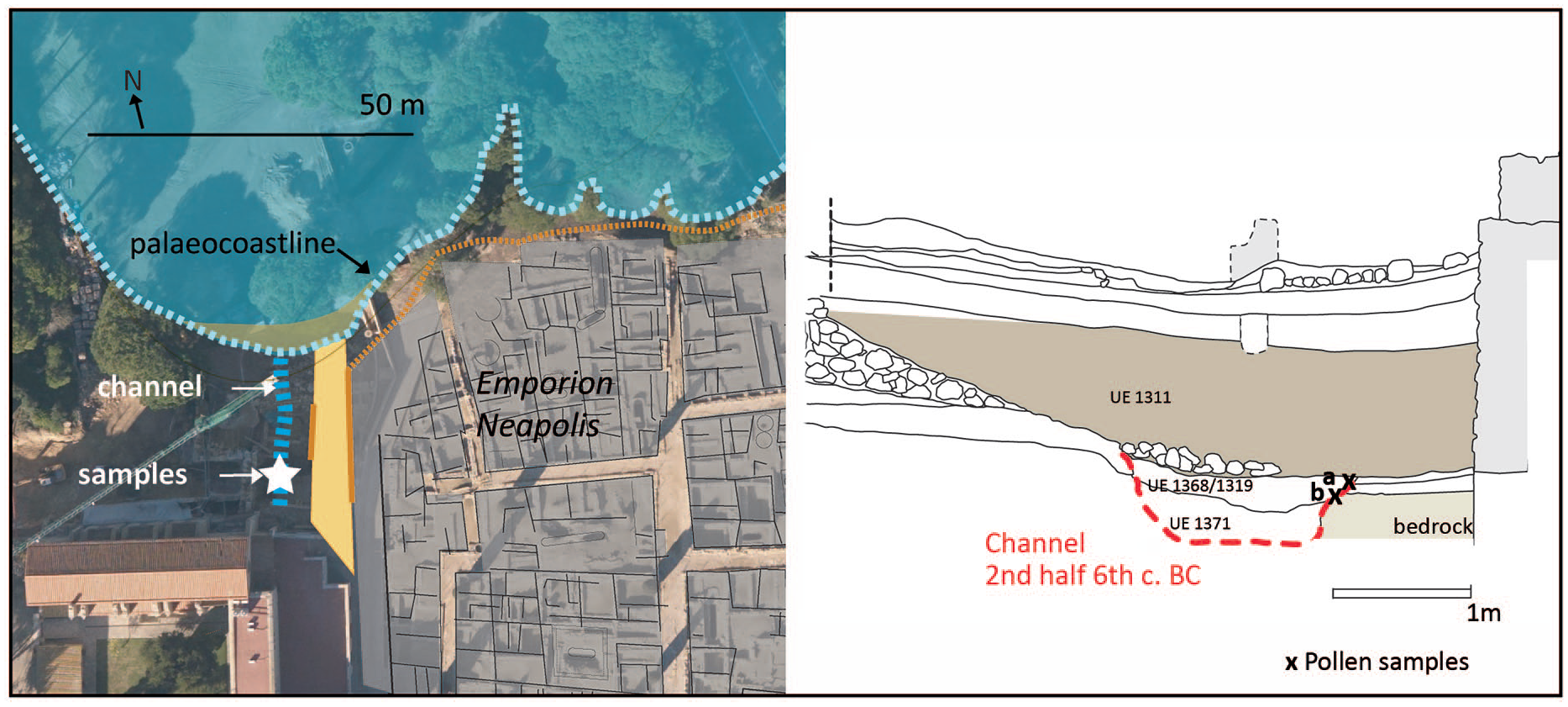
Location of the excavated drainage channel in the Emporion Neapolis and of samples taken for pollen analysis.
Chronology
Six accelerator mass spectrometry (AMS) 14C measurements were obtained from Beta Analytic Inc (Miami, USA) using peat and plant and charcoal remains. The dates were calibrated with CLAM v. 2.3.5 (Blaauw, 2010) using the IntCal20 14C calibration curve (Reimer et al., 2020). The age-model was developed with CLAM v. 2.3.5 using a smoothing spline fitted to the median age of each calibrated radiocarbon date (Blaauw, 2010).
Mineralogy and geochemistry
Samples were oven-dried at 60°C, sieved at 250 µm, and milled in an agate mortar for x-ray diffraction to determine their mineralogical composition. One gram of dried sediment was then used to calculate the organic matter content by loss on ignition at 550°C in a muffle furnace (Dean, 1974; Heiri et al., 2001). Subsequently, 0.1 g of these samples were processed for total acid dissolution in 25-ml PTFE beakers following the methods of Luo and Ku (1991). Geochemical analysis of elemental composition was performed at the Scientific and Technological Centre of the University of Barcelona using an inductively coupled plasma spectrometer (ICP-AES). Geochemical values were normalised using the Ti content, an element rarely involved in biological and early diagenetic processes (Covelli and Fontolan, 1997).
Pollen, non-pollen palynomorphs (NPP), charcoal and macrofauna
Pollen and NPP analyses were performed following standard procedures (Faegri and Iversen, 1989). Microfossils were identified on a light microscope at 500× and 1000× magnification, and microcharcoal particles ⩽200 μm were tallied using a binocular microscope at 80× magnification. Pollen and NPP identification followed published illustrations and morphological keys (e.g. Beug, 2004; Punt et al., 1976–2009; Reille, 1992; van Geel, 2001; van Geel and Aptroot, 2006), and the GEOLAB’s pollen reference collection. In addition, Poaceae grains ⩽26 µm were classified as Phragmites-t (Chester and Raine, 2001), while those with grain dimensions ⩾40 μm, and with an annulus diameter ⩾12 μm were classified as Cerealia-t (Faegri and Iversen, 1989). Cichorium intybus-t and Quercus suber-t were identified according to the morphological criteria detailed in Moore et al. (1991) and Planchais (1962), respectively. NPP types were assigned to an existing code when already described in the catalogues of the Hugo de Vries Laboratory (HdV), University of Amsterdam (Netherlands) and of the University of Toulouse – le Mirail, Toulouse (France). At least 400 terrestrial pollen grains were counted per sample, together with the sum of the NPP types identified during pollen counting. Pollen and NPP values are expressed as percentages of the total terrestrial pollen sum, which excludes Cyperaceae, fern spores and aquatic plants. Lycopodium clavatum spore tablets (Stockmarr, 1971) were added in order to calculate pollen concentration. Pollen and NPP taxa were assigned to ecological groups in accordance with local vegetation descriptions and a specialised bibliography (Table 1). The indeterminable curve includes unidentified corroded, degraded and broken pollen. Because the Cichorieae and indeterminable pollen curves followed similar trends and showed poor preservation in specific parts of the record, undifferentiated Cichorieae pollen was excluded from the apophyte curve. Pollen infilled with pyrite crystals was classified as pyritised pollen, and was used as an indicator of sulphide-rich anoxic environments.
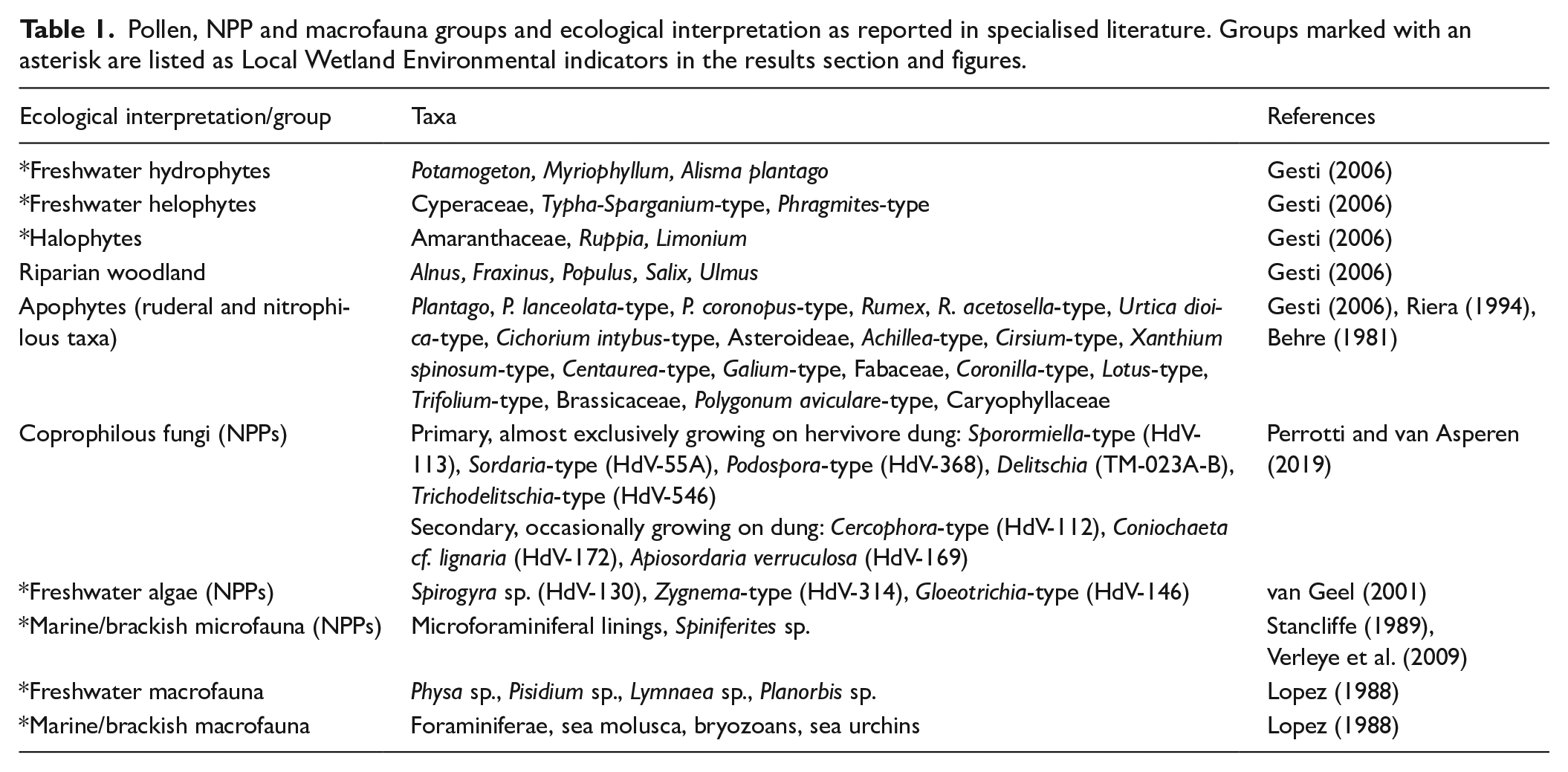
Pollen, NPP and macrofauna groups and ecological interpretation as reported in specialised literature. Groups marked with an asterisk are listed as Local Wetland Environmental indicators in the results section and figures.
Macrofauna were recovered from the fraction used for sedimentological analysis after sieving at 250 µm. They were picked-out using a light microscope at 80× magnification and classified on the basis of their ecological preferences as fresh or saline water indicators (Table 1).
Stratigraphic diagrams of the various proxies were prepared using C2 software v. 1.7.2 (Juggins, 2011). Zonation of pollen and geochemistry diagrams was established using CONISS (Grimm, 1987).
Results
Lithology and age-depth model
The record develops over a Plio-Pleistocene palaeosoil characterised by the occurrence of calcrete. The lithostratigraphy of the core consists of a 127-cm-thick basal unit of organic-rich dark brown muds (between 300 and 173-cm-depth) overlain by a 30-cm-thick peat layer (Figure 3). The latter is overlain by brown muds between 143 and 90 cm in depth, above which brown anoxic bioturbated muds developed. Figure 3 shows results of 14C dating and the constructed age-depth model for the Els Estanys record. Radiocarbon dates occur in stratigraphic order supporting continuous sedimentation from ~1500 cal BC to the seventh century AD. Based on the age-depth relationships, minimum sediment accumulation rates (SARs) ranging from ~0.06 to 0.08 cm/year are documented up to 250 cm in depth. These are followed by a rise up to maximum SARs of ~0.3 cm/year at 190-cm-depth. The upper peat and muddy units show decreasing SARs down to 0.07 cm/year at 90-cm-depth. According to the age-depth model and the sampling resolution for palynological analyses, the Greco-Roman period (from the sixth century BC to the third century AD) was studied at a high-temporal resolution. Each 1 cc sample studied for this period includes a lapse time between 3 and 13 years, with intervals between studied samples covering a mean time resolution of ~30 years. A continuous analysis without intervals with a time resolution of 10 years/cc was performed between 139 and 147 cm in depth, a section that according to our age model covers the first century cal BC.
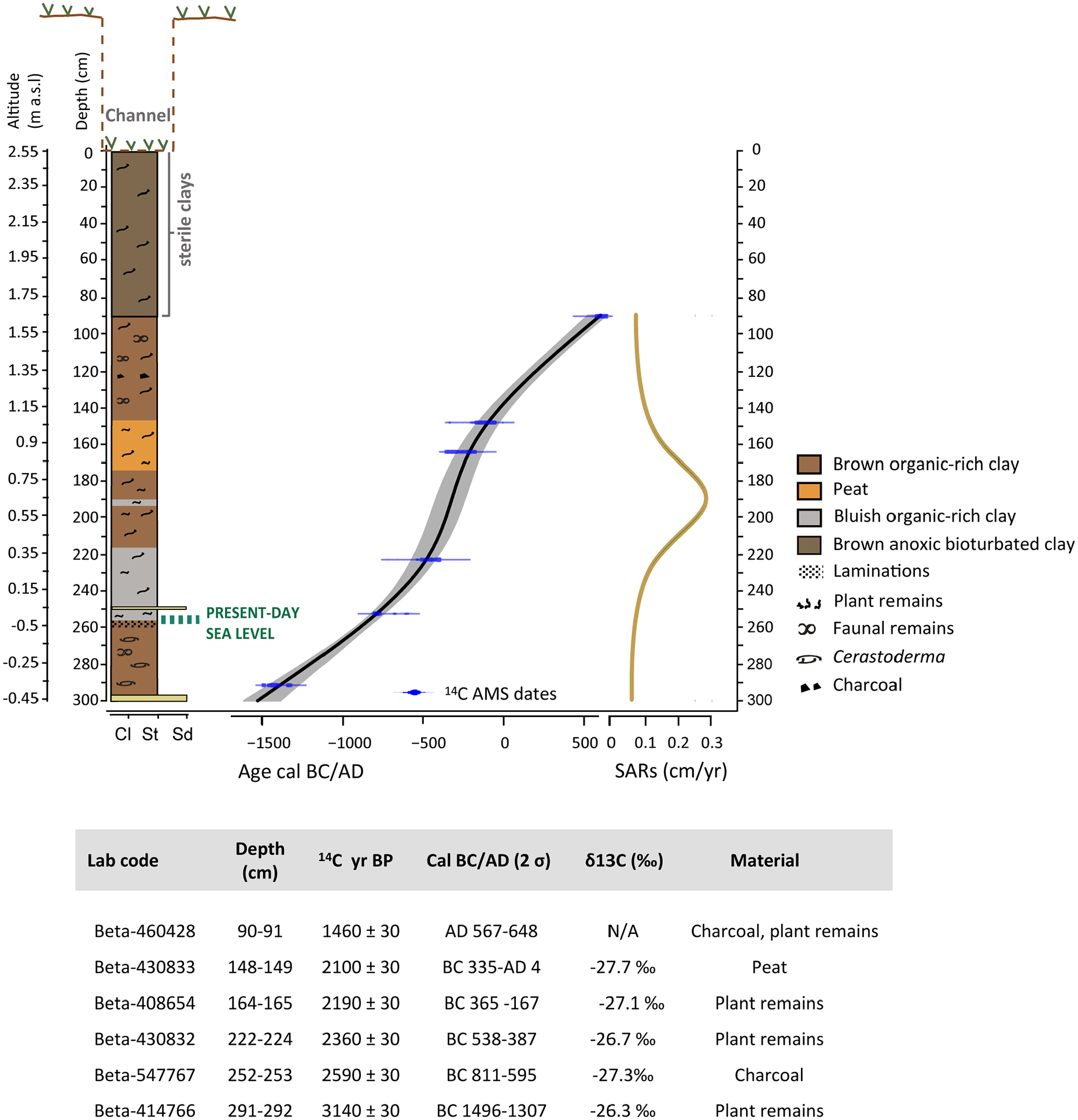
Stratigraphy, age-depth model, sediment accumulation rates (SARs) and dating results for the Els Estanys record.
Palaeoenvironmental results
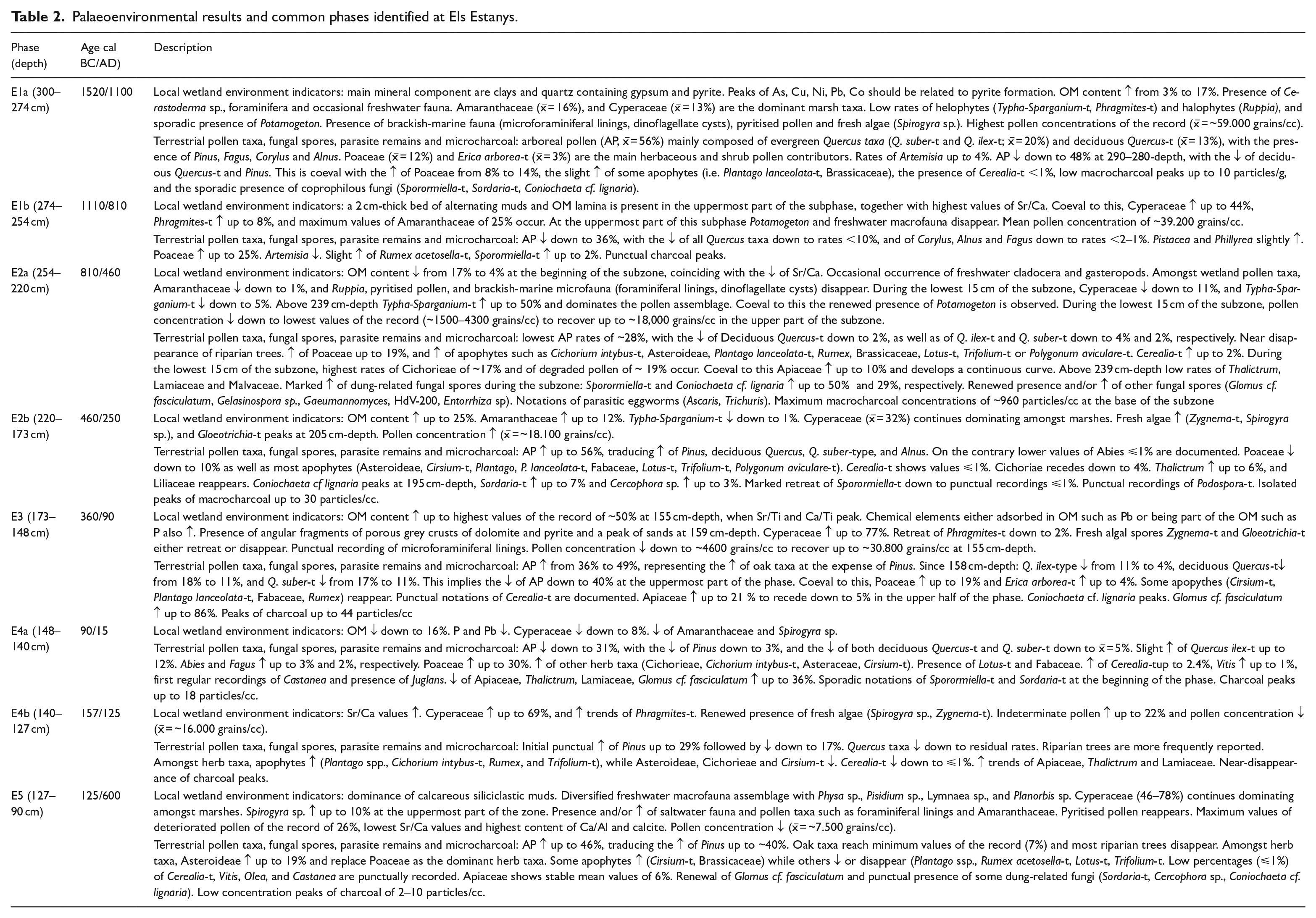
Selected pollen and NPP results are shown in Figure 4, together with macrocharcoal and macroremain results. Figure 5 shows the mineralogical and normalised elemental composition of the record. Figure 6 correlates lithological, pollen and geochemical stratigraphic zones. The consistencies between the different zone boundaries for the Els Estanys record were used to establish a total of five common environmental and landscape change phases (E1–5). These common phases are used hereinafter to zone the different proxies’ diagrams. Palaeoenvironmental results obtained in the five common phases are described in Table 2. The local wetland environment indicators group listed in the table include mineralogy and geochemistry proxies as well as marsh and wetland pollen taxa, pyritised pollen, algal and faunal NPPs, and macrofaunal remains (see Table 1 for more information on the specific taxa included within this group).
Palaeoenvironmental results and common phases identified at Els Estanys.
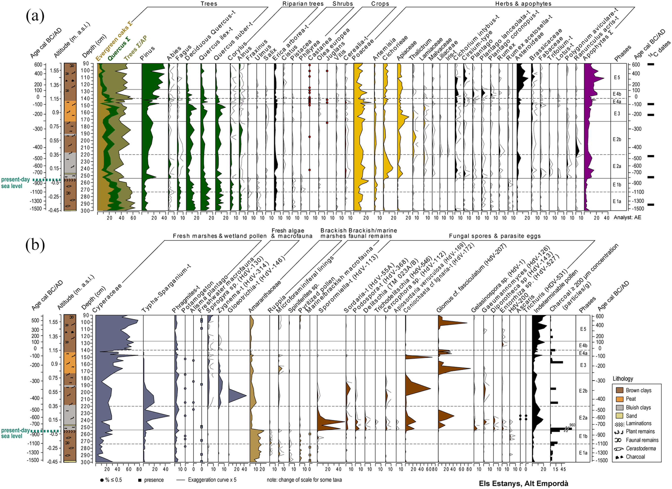
Selected biotic proxy results documented at Els Estanys record. (a) terrestrial pollen percentages and (b) marsh and wetland pollen and NPP percentages, macroremains presence, and microcharcoal concentrations.
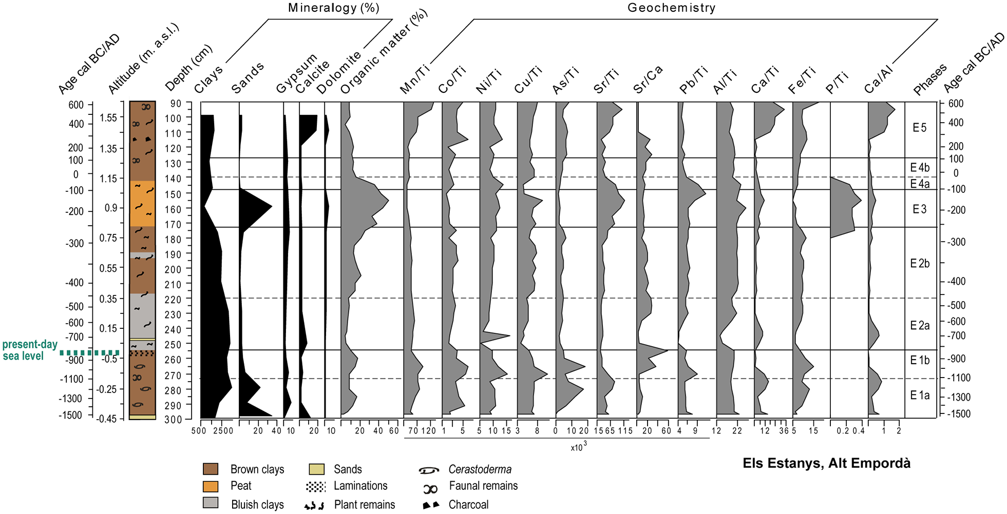
Mineralogy results, organic matter content and selected geochemical proxy ratios for Els Estanys.
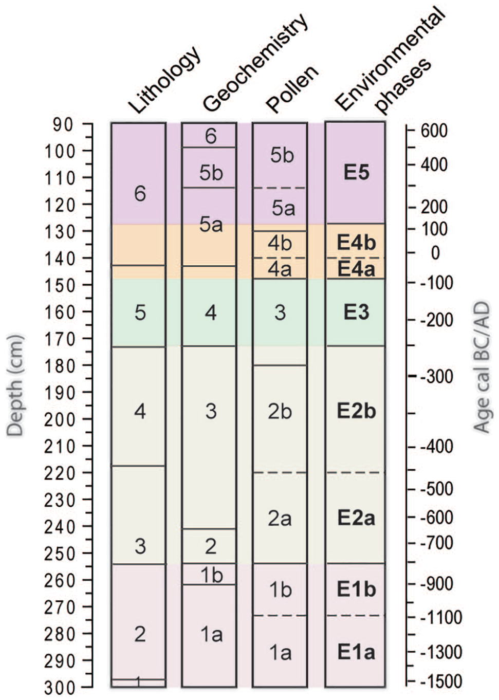
Correlation of stratigraphic zone boundaries defined for the different proxies, and resulting five common environmental and landscape phases (E1–5) used in the result description and interpretation.
Channel sample results
Figure 7 shows selected pollen and NPP results obtained at the Emporion archaeological channel. The two studied samples showed good pollen preservation and low pollen concentrations of 172–230 grains/g. The pollen assemblage was dominated by non-arboreal pollen (51–53%), with Poaceae (14–20%) and Artemisia (7–13%), and to a lower extent Amaranthaceae and Cyperaceae (up to 5%) dominanting amongst herbs. Plantago lanceolata-type and Cichorieae were also present at rates up to 3%, and Brassicaceae and Phragmites-type at rates of ~1%. The only well-represented shrub taxa was Erica arborea-type, with rates up to 6%. Pinus (36–39%) dominated the tree pollen, followed by Quercus ilex-type (5–7%) and deciduous Quercus-type (2%). The presence of riparian trees was otherwise recorded. Amongst the potentially cultivated crop taxa, Olea was recorded with rates of 1–3%, together with Cerealia-type (1–2%) and residual rates of Juglans and Vitis.
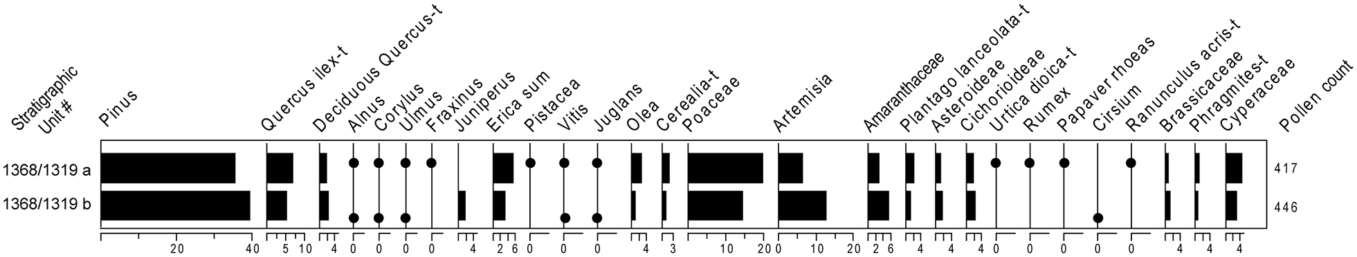
Pollen percentages for the Emporion Neapolis channel.
Discussion
Phase 1a/b: 300–254-cm-depth (~1520 to ~800 cal BC): A shallow marine-influenced lagoon within an increasingly cleared landscape during the Late Bronze Age
The Els Estanys lagoon developed after 1520 cal BC in a context of shoreline progradation and attenuated sea level rise that favoured the formation of back barrier lagoons in the area since 6000 cal BP (Montaner et al., 2014) (Figure 1b). This phase is located just below the present-day sea level, and its uppermost limit records the maximum sea flooding (MSF) surface at ~810 cal BC, suggesting a maximum water column of ~50-cm-depth at the drilled point. The documented low SARs (0.04 cm/year) are common of back beach lagoons during MSF, a process also recorded at ~880 cal BC in the nearby Castelló lagoon, located only 15 km to the north (Ejarque et al., 2016). Coincident results obtained in both the Castelló and Els Estany lagoons corroborate the finding that MSF occurred during the ninth century BC in the Empordà plain. High values of Sr/Ca (Figure 5), as well as the presence of marine-brackish NPPs (microforaminiferal linings, dinoflagellate cysts), marine-brackish macrofauna and pyritised pollen (Figure 4b) point to the existence of a shallow wetland with a marine water influence through a sand barrier. The local vegetation was dominated by halophytic marshes (Amaranthaceae, Ruppia) and brackish-tolerant sedges (Cyperaceae) (Figure 4b). The relative abundance of Artemisia is indicative of the proximity of alkaline dry sandy soils likely developing behind the sand barriers closing the estuarine area, which are documented to the NW of Empúries (Montaner et al., 2014) (Figure 1b). Occasional freshwater inputs from fluvial distributary channels are indicated by the occurrence of freshwater fauna, plants (Typha, Potamogetonaceae) and algal remains (Spirogyra sp.) (van Geel, 2001). From 850 BC, and coinciding with the MFS, the expansion of salt marshes (Amaranthaceae), the maximum Sr/Ca values and the disappearance of freshwater hydrophytes and macrofauna indicate increased salinity in the lagoon (Figure 4b). At the same time, the marked development of Cyperaceae and the rise of Phragmites-type, helophytes with a high tolerance to brackish conditions but requiring less frequent inundation periods than salt marshes, suggest shorter marine flooding periods. The coincidence of all this with maximum Sr/Ca values matching the present-day sea level (Figure 5) points to an ontogenic process of lagoon infilling and geochemical change in water composition. Colder and more arid climate conditions may also have contributed to shorter flooding periods at Els Estanys. Indeed, marine ice rafting events in the North Atlantic (Bond et al., 2001) point to a change towards colder conditions at around 2.8 ky cal BP (~850 cal BC), which are matched with a phase of increased aridity documented in the Western Mediterranean (Jalut et al., 2000) (Figure 8).
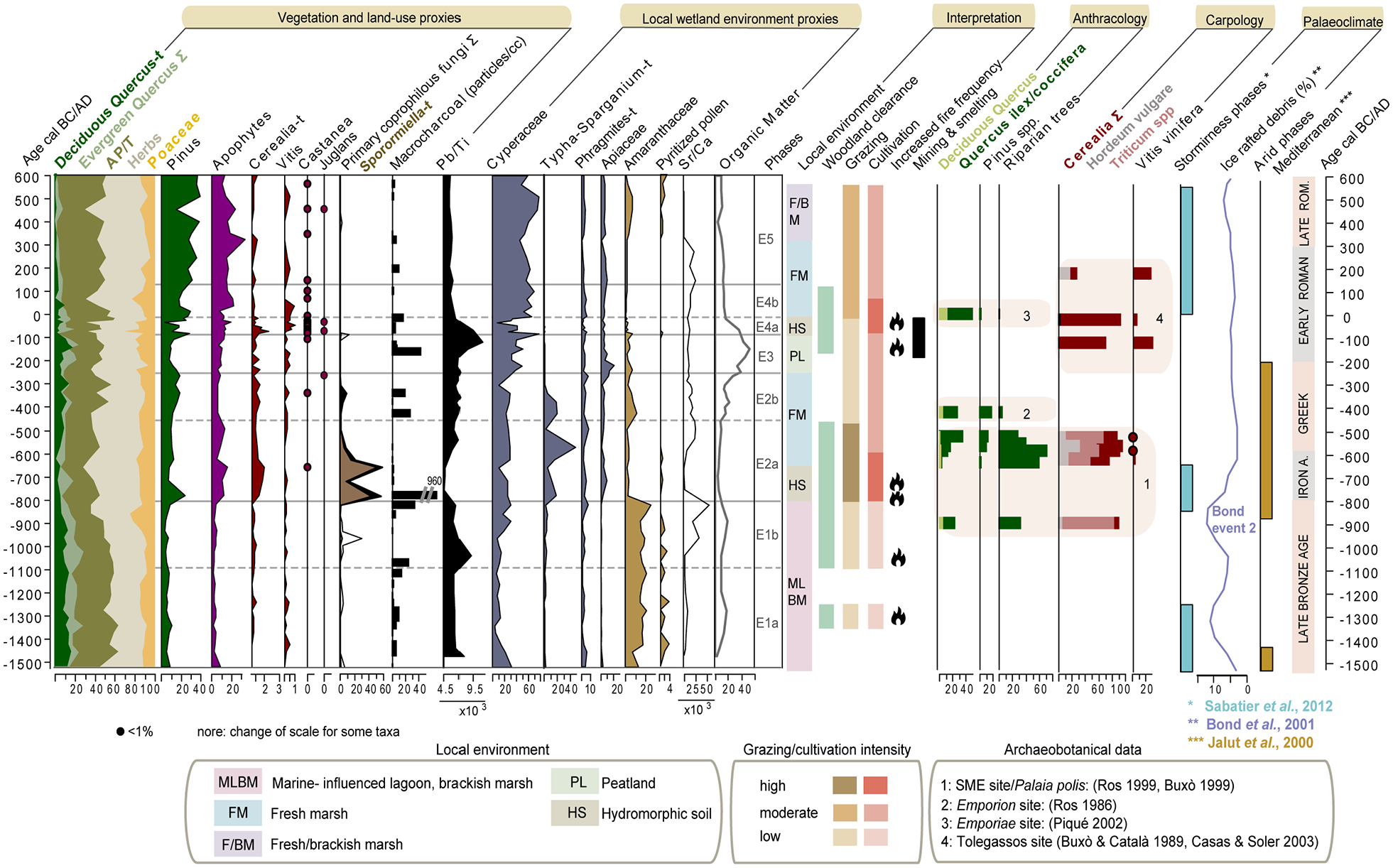
Key selected variables of vegetation, land-use and local environment changes at Els Estanys, together with their interpretations and relevant palaeoclimatic and archaeobotanical information.
According to the moderate Arboreal Pollen (AP) rates, relatively open Mediterranean woodlands dominated by evergreen oaks covered nearby coastal ranges (Figure 8). Cork oaks (Quercus suber-type) likely developed on siliceous soils of the Gavarres Mountains, while holm oaks (Quercus ilex-type) grew on coastal ranges. Deciduous oaks and patches of riparian trees (Figure 4a) developed in the deeper moister soils of the floodplain and along riverbanks, as well as in valleys and flats in coastal ranges. Low rates of Fagus pollen also suggest the presence of beech within the latter. Within this context, a short-lived fire-related oak woodland clearance is documented between 1350 and 1250 cal BC. A coeval slight rise in apophytes, and the presence of cereal pollen, dung-related fungi, and peaks of macrocharcoal (Figure 8) suggests the existence of punctual low-intensity agropastoral activities in the moister deeper soils of nearby valleys and fluvial terraces. Although there is no archaeological evidence of human settlement in the area for this specific period, seasonal occupation of the littoral promontories is reported in the archaeological record since the Late Neolithic (Casas and Soler, 2004; Tarrús, 1980).
Enhanced deforestation occurred between 1100 and 800 cal BC, with the sustained clearance of deciduous and evergreen oaks, beech and riparian trees, and expansion of grasslands (phase E1b, Figure 4a). At the same time, renewed low-intensity farming within the lagoon’s catchment is suggested by the presence of Cerealia-type pollen and the rise of some apophytes (i.e. Rumex acetosella-type, Plantago spp, Cichorium intybus-type). This moderate agro-pastoral exploitation of the littoral plain and increasingly cleared landscape coincides with the first human settling in the area. Indeed, late Bronze Age Urnfield communities are first documented between the 11th and 9th centuries BC at the Sant Martí d’Empúries (SME) and Mas Gusó open-air sites, and at the Urnfield burial site of Vilanera (Figure 1b). All of these were located at the northern- and westernmost promontories of the Montgrí Massif, which at this period were surrounded by lagoonal and estuarine environments (Castanyer et al., 2016; Figure 1b). Archaeobotanical and faunal remains recovered at the SME site stress the reliance of these prehistoric groups on cereal cultivation (Buxó, 1999) and goat and sheep herding (Casellas, 1999). According to the moderate percentages of the documented apophytes during this period, lagoonal areas were still poorly exploited, and agro-pastoral activities tended to focus on nearby valleys and fluvial terraces. However, landscape opening was of a larger magnitude than before. It is most likely that coastal ranges located outside the lagoon’s catchment were also being increasingly exploited, resulting in an open littoral landscape at a regional scale. Supporting this, the Sobrestany pollen record located at the foot slopes of the Montgrí Massif (Figure 1a) also shows a retreat of Mediterranean oak woodlands since 1100 cal BC (Parra, 2012). The simultaneous retreat of mesophilous and xerophylous trees at els Estanys between 1100 and 800 cal BC does not point to climatic variability or increased aridity as a main trigger of landscape openness. Rather, the opening of evergreen oak woodlands may have been favoured by human exploitation. This is supported by anthracological data from the SME site that shows that holm oaks were amongst the preferred tree taxa exploited for fuelwood and timber by local Late Bonze Age communities (Ros, 1999). The moderate rise in crop pollen and apophytes also argues in favour of an anthropogenic forcing behind this landscape opening from 1100 cal BC, and its relation to the establishment of Urnfield societies in the area.
Phase 2 a/b: 254–173-cm-depth (~800 to ~250 cal BC): Fluvial flooding, lagoon freshening and the first agropastoral exploitation of the mud flat during the Iron Age; continued indigenous land-uses and reduced exploitation of the Emporion hinterland during the Greek period
Two main environmental episodes can be observed amongst the local proxies. First, between ~800 and 630 cal BC (254–239-cm-depth), the retreat of halophytes and sedges, minimum values for OM content, lowest pollen concentration and the rise of terrestrial fungal spores all suggest lowered water tables and the development of a hydromorphic soil in this marginal area of the estuary. The bottom sediments of the lagoon were at this time above sea water influence, and were fed mainly by minor overland drainage and possibly by freshwater underground recharge through Neogene gravels. However, the area was exposed to occasional storm washovers, as suggested by the occurrence of a sand layer at 249-cm-depth (~750 cal BC). Second, above 239-cm-depth (~630 cal BC), rises in OM and gypsum and low Sr/Ca ratios (Figure 5) indicate the increased influence of fluvial flooding and clay flocculation, which would result in a rise in the mud flat’s accretion rate (Figure 3). This is coeval with the development of freshwater marshes dominated by sedges (Cyperaceae), bulrush (Typha-Sparganium-type) and other reeds and tall-herbs (Phragmites-type, Apiaceae, Malvaceae, Iris-type). The local expansion of freshwater marshes is further supported by the recording of parasitic fungal spores either growing on the roots of sedges and rushes (i.e. Entorrhiza) (Chater and Smith, 2018), or associated with locally-growing sedges (i.e. Gaeummanomyces) (van Geel, 1986) (Figure 4b). The existence of a local environment dominated by freshwater marshes during the Iron Age matches Estrabon’s description of the Emporion’s plain as ‘Campus Juncarius’ or Juncarian Plain (Geog. III, 4, 9). Freshwater-dominant conditions suggest the development of a more permanent and continuous sand barrier between the lagoon and the sea. This could be related to the development of a Fluvià river lobe towards the south. Fluvial avulsion, increased flooding, and punctual storm surges occurred during a phase of high storm activity recorded in the Gulf of Lyon between ~850 and 650 cal BC (Sabatier et al., 2012) (Figure 8).
This environmental change coincides with the first marked and persistent farming exploitation of the mud flat between ~800 and ~450 cal BC (phase 2a, Figure 8). Grazing exploitation of coastal wetlands such as Els Estanys is indicated by the expansion of pasturelands and apophytes, maximum rates of dung-related fungi including the obligate coprophilous fungi Sporormiella-type, and the presence of the eggs of worms parasitising domesticated herds (i.e. Trichuris, Ascaris; Figures 4b and 8). The synchronous presence of macrocharcoal peaks and the fire-related fungi Gelasinospora sp. (Blackford et al., 2006) evidence the existence of local fires (Figure 4b), probably employed as a clearing tool to remove marshy vegetation and promote wet pastures. The lagoon infilling, development of hydromorphic soils, and subsequent freshening of the wetland likely fostered grazing exploitation of its marginal areas. In addition, increased rates of Cerealia-type pollen up to ~2% (Figure 8) point to development of nearby cultivated fields. These were probably located in Neogene fans bordering the lagoon and sheltered from fluvial and sea flooding. Increased agropastoral activities contributed to enhanced clearance of mixed oak woodlands and the near disappearance of riparian trees. They also favoured the development of secondary pinewoods well-adapted to unstable substrates, agropastoral disturbance and burning (Figure 8).
This phase of intensified farming exploitation coincides with the beginning of permanent settlement in the area during the early Iron Age. Indeed, since 650 cal BC, the SME and Mas Gusó Iberian sites, built using non-perishable materials, are documented in the Montgrí Massif promontories (Figure 1b). Anthracological data obtained at the SME site confirms that evergreen oaks, scrublands and pine, together with riparian trees, were exploited for timber and fuelwood (Ros, 1999) (Figure 8). Archaeobotanical analyses at this site also stress a change towards a more diversified agriculture since 650 cal BC following the beginning of trade with Phoenicians and Greeks. Indeed a variety of new crops are newly recorded in domestic contexts, mainly cereals such as free-threshing wheat, millet and oats, but also flax, cultivated olive and grapes (Buxó, 2001, 2008; Figure 8). The documented increase in cereal pollen is probably related to such diversification in grain cultivation. However, sporadic residual pollen rates <1% of Olea, Vitis, and Castanea documented at Els Estanys indicate the minor role that these cultivated taxa played in the hinterland during the Iron Age.
Major socio-economic changes followed Greek colonial settling in the area and the foundation of Emporion at ~580–540 BC, including the development of urbanism, introduction of coinage, and increased regional commerce and imports (Aquilué et al., 2010; Castanyer et al., 2016). However, according to the pollen results, establishment of the Greek colony did not trigger significant changes in the vegetation or land-use of the immediate hinterland. Indeed, as before, the cleared mud flat continued to be exploited for cereal and pastoral purposes, and no significant introduction of new crops is attested during the Greek period. The latter is in accordance with archaeobotanical analyses performed in the Emporion Palaia Polis (Buxó, 1999) (Figure 8). Indigenous land-uses and farmed landscapes established since 800 cal BC, and based on cereal cropping and pastoral exploitation, endured thus under the Greek colonial settling. The marked intercultural hybrid character of Emporion surely contributed to this. According to both historical sources and the archaeological record, both colonial and indigenous traditions and populations inhabited and mingled in Emporion (Aquilué et al., 2010). Following this, appearance of a number of Iberian huts and silos, as well as of ceramic concentration sites (Figure 9a) in the hinterland further support continued and expanded indigenous rural occupation during the Greek period.
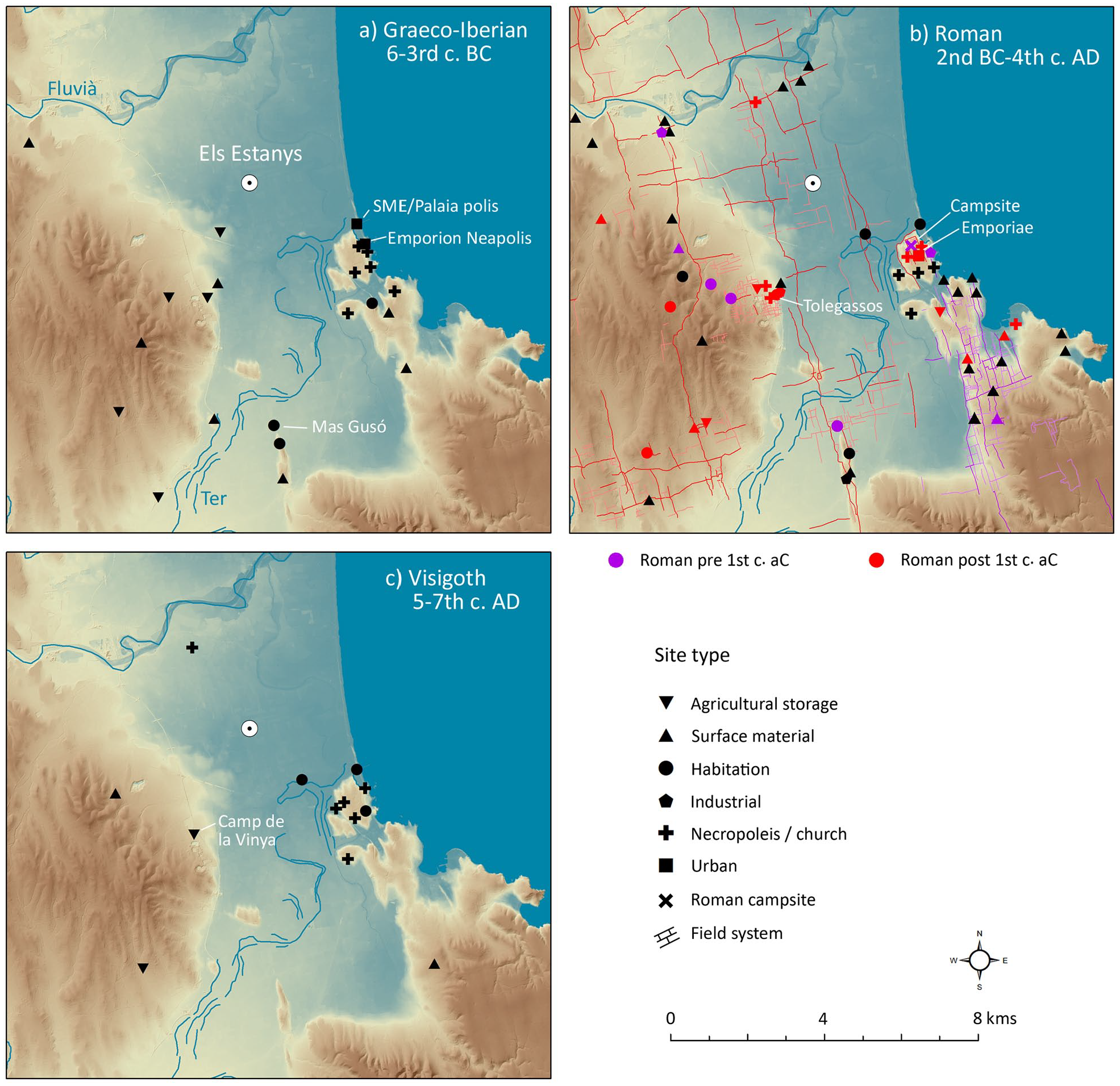
Maps showing the distribution of archaeological sites in the study area: (a) Iron Age, (b) Roman and (c) Visigoth period.
Pollen results obtained from the Neapolis channel and dated to the second half of the sixth century BC provide further insights into Emporion colonial urban and periurban landscapes. Globally, pollen results from the channel agree with those obtained from the hinterland. They point to the existence of a largely cleared landscape dominated by grasslands with the presence of tree-heath scrub (Erica arborea-type) and sparse holm oaks. Pine pollen rates were four times higher than those documented from the hinterland, but still moderate considering that pine is a great pollen producer. They indicate the sparse presence of pines near to or within the urban context, probably as a perimetral or ornamental tree. The documented rates of Cerealia-type (~2%) and apophytes (i.e. Plantago lanceolata-type, Brassicaceae) are globally similar to those documented in the hinterland, and suggest agropastoral exploitation near to the colony. Interestingly, maximum Olea rates of 2.9% are seven-fold higher than maximum Olea rates attested at Els Estanys (0.4%) for the Greek period (Figure 4a). Olea pollen includes both cultivated and wild olive species, and we should be cautious when interpreting low rates. If we use as a reference rates documented in pollen analyses from modern olive groves (Florenzano et al., 2017), residual sporadic notations of Olea ⩽1% documented at Els Estanys indicates that olives, either wild or cultivated, were rare in the Emporion hinterland. On the contrary, higher Olea rates ⩾2% documented in the vicinity of the colony (Figure 7) may be indicative of the presence of olive groves within a distance of 500–1000 m (Florenzano et al., 2017). This could be related to the development of localised olive orchards in periurban areas and/or the presence of olives within the urban context itself as a decorative tree in gardens or public spaces. Olive trees had a significant economic, identity and symbolic value for Greek societies. They were planted along roadsides and were the most regularly used perimetral tree in ornamental gardens in classical Greece (Foxhall, 2007). The localised presence of olive groves in the vicinity of the colony indicates that they formed part of the urban development of Emporion since its foundation. However, their minor role in the rural landscape suggests that olives probably played a more symbolic ornamental role, rather than a productive one, during the Greek period. This contrasts with pollen data from the rural hinterland of other Greek colonies such as Metaponto in central Italy, where olive groves played a more important role (Florenzano et al., 2013).
Since 450 cal BC (E2b), the retreat of apophytes (Asteroideae, Cirsium-type, Plantago, P. lanceolata-type, Fabaceae, Lotus-type, Trifolium-type, Polygonum aviculare-type) and grassland pollen match with the rise of pine, deciduous oaks and alder. This is coeval to the drop of the obligate dung-related fungi Sporormiella-type, and a less diversified range of coprophilous fungi (Figures 4 and 8). Continued presence of cereal pollen is otherwise attested. All these evidence points to continued, but lowered farming activities leading to the recovery of littoral woodlands. Woodland recovery and the local expansion of fresh marshes would lead to increased plant matter and nutrient load in the lagoon. This is indicated by rises in OM content, algal blooms (Gloeotrichia-type) and non-obligate dung-related fungi such Sordaria-type, Podospora-type Cercophora-type and Coniochaeta cf lignaria-type, which also develop in multiple decomposing organic substrates (Lundqvist, 1972; Perrotti and van Asperen, 2019). Since ~600 cal BC and during the rest of the Greek period, woodland recovery and lowered agropastoral exploitation is also documented regionally in the Castelló lagoon’s pollen record (Ejarque et al., 2016). Surprisingly, such woodland recovery and lowered farming exploitation than before occurred during the flourishing of Emporion as a major regional trade and economic centre during the fifth and fourth centuries BC (Castanyer et al., 2016; Plana, 2004). The consolidation of regional trading networks between the colony and neighbouring inland Iberian communities may have resulted in increased import of regional agricultural products and lowered pastoral exploitation of the immediate coastal hinterland. Indeed, archaeologists relate the multiplication of storage silos in the Iberian oppida of Pontós and Perelada, located in north-western inner areas of the Empordà floodplain, with the production of agricultural surplus that would be traded through the colonial markets of Emporion and Rhode (Plana, 2004).
Phase 3: 173–148-cm-depth (~250 to ~90 cal BC): A peatland within a largely cleared landscape during the Roman conquest of Iberia
From 250 cal BC, maximum OM values and the rise of some chemical elements related to OM (P and Pb) point to the development of a peatland at Els Estanys. This is further supported by the replacement of frequently-inundated tall grasses (i.e. Typha, Malvaceae) and hydrophytes by Cyperaceae and Apiceae growing in moist peaty soils. The occasional presence of marine fauna could be related to the punctual exposure of the peatland, which is located only one meter above the present-day level (Figure 3), to storm-related high-energy waves. These can reach up to 1 m in height in this area (Marqués et al., 2001). The presence of angular fragments of porous grey crusts of dolomite with a sandy texture at ~175 cal BC are likely due to diagenetic processes related to water table oscillations. The development of this peatland should be related to the ontogenic evolution of the freshwater lagoon and the dominant influence of underground alkaline waters draining the nearby Neogene foot slopes over fluvial inputs (Montaner et al., 2014).
Since 150 cal BC, a major clearance of oak woodlands and expansion of pastures (Poaceae, Asteroideae, Brassicaceae) and heath scrub occurs together with an increased frequency of fires. The slight rise of apophytes and low rates of crop pollen indicate only moderate agropastoral exploitation. This landscape change follows the landing and establishment of Roman troops in the area during the second century BC within the context of the Roman conquest of the Iberian Peninsula, and immediately precedes the foundation of the Emporiae Roman city during the first century cal BC. Roman occupation will have important consequences on both the urban and rural occupation of the area. First, a large Roman military campsite of ~20/21 ha is installed immediately to the west of the Emporion Neapolis during the second quarter of the second century BC. This campsite functioned until 125 BC and was likely oriented towards the training of indigenous auxiliary troops (Castanyer et al., 2016). Second, there is intensified indigenous rural occupation of the hinterland. This is attested by the appearance during the second century–early first century BC of a number of indigenous rural sites and storage silos at the footslopes near Els Estanys (Figure 9b). A similar pattern is observed in the nearby Montgrí Massif, with the development of localised field systems and the appearance of new rural sites (Figure 9b) (Palet et al., 2021). Such intensified indigenous rural occupation follows the presence of Roman troops and the disappearance of major Iberian oppida in the region (Casas et al., 2010). Intensified occupation of nearby ranges and increasing needs for wood and building materials for the construction and maintenance of the Roman camp probably contributed to the clearance of Mediterranean woodlands. In addition, peak values of Pb at 151-cm-depth (~120 cal BC) point to the development of regional mining and smelting activities. These were probably promoted to meet the increasing needs for metal supplies and coinage for the Roman troops.
Phase 4: 148–127-cm-depth (~90 cal BC to ~125 cal AD): The shaping of Roman rural landscapes: Hydrological management, increased settlement and diversified farming of the hinterland
Since the first century BC (E4a), the shift from peat to clays and the decrease of OM content points towards a transition from a peatland to a mud flat (Figure 5). Marshes and tall-herbs (Cyperaceae, Apiaceae) are replaced by grasslands dominated by Poaceae. This is coeval with the increased presence of herbs growing in non-permanently flooded soils (Asteraceae, Cichorieae, Cirsium-type), and the disappearance of fresh algal spores. All these indicates lowering of water tables and the development of hydromorphic soils. The sporadic presence of dung-related fungi also suggests punctual grazing activities within the Els Estanys catchment. Coeval with this, a rise in Cerealia-type (~2.4%) and Vitis (~1%) pollen, together with the regular occurrence of Olea, Castanea and Juglans, indicates the development of more diversified cropping activities, which for the first time included vines, chestnuts and walnuts. Controlled fires were likely used to promote an open farmed landscape during the first century BC. This is suggested by charcoal peaks and the clearance of pinewoods during subzone E4a.
Since ~20 cal BC (E4b) a rising trend in Sr/Ca points to increased salinity of the hydromorphic soils, while more frequent flooding is suggested by the renewal of freshwater algae and the local development of helophytic marshes. These were dominated by sedges (Cyperaceae), with the presence of tall-herbs (Apiaceae, Phragmites-type, Thalictrum, Lamiaceae). Such helophytic marshes reassemble the Cypero-caricetum otrube (Magnocaricion) plant community that typically grows in the Empordà on soils of moderate salinity that are flooded for short periods, such as wetland margins and/or channels (Gesti, 2006). Frequent periodic flooding also promoted the renewed presence of riparian trees such as elm, ash and willows on moist floodplain soils and along fluvial corridors and/or drainages. Flooding oscillations and related water evaporation could also explain the reported increased salinity of soils. Coinciding with all this, regional expansion of wet pastures and enhanced agropastoral exploitation occur. This is suggested by the replacement of Asteroideae and Cichorieae pollen by apophytes typically growing in the wet meadows of Empordà such as Plantago ssp., Cichorium intybus-type, Rumex and Trifolium-type (Gesti, 2006). In line with the expansion of wet meadows, dental microwear analysis on sheep and goat assemblages from the Tolegassos and Mas Gusó Roman sites points that the dietary regime of local herds was compatible with the grazing of littoral wet pastures and marshes (Gallego et al., 2017). Increased agropastoral exploitation of the hinterland further contributed to enhanced woodland clearance, leading to the near disappearance of oaks during this subzone.
Such increased farming of the plain in a context of lowering water tables, subsequent flooding oscillations, and expansion of fresh marshes and wet pastures may be related to the anthropogenic hydrological management of the plain and the development of a drainage system. During the first century BC, a major threshold in the human occupation of the plain occurred, with the founding of the Roman city of Emporiae, expansion of centuriated field systems (Palet et al., 2021), and proliferation of Roman rural sites and farms (villae) (Figure 9b). Two of these farms, the Olivet d’en Pujol and Tolegassos, are documented near Els Estanys from the late second century to early first century BC (Casas and Soler, 2003; Casas et al., 2013). Close to the Tolegassos villae (Figure 9b), several ditches have been documented as being abandoned in the fourth century AD (Nolla et al., 2012). These followed the orientation of the first century BC Roman centuriation and have been interpreted as limiting and drainage ditches linked to the Roman villae (Palet et al., 2021). Increased rural settlement and the development of a drainage system to hydrologically control inland areas of the plain probably triggered the aforementioned palaeoenvironmental and landscape changes documented at Els Estanys.
Archaeobotanical analyses available in the area for the Roman period generally agree with the pollen results. Anthracological assemblages from Emporiae dated to the first century BC stress the exploitation of holm oaks, heath scrub and deciduous oaks, as preferred taxa for fuel and wood provision (Piqué, 2002). This exploitation surely contributed to the decreasing trends in these pollen taxa reported for Els Estanys. This together with enhanced clearance of pine woodlands resulted in a largely cleared landscape. The development of more diversified cropping activities, which included enhanced cereals, and for the first time, vine cultivation near Els Estanys, is further confirmed by archaeobotanical evidence at the Tolegassos villa, which shows a high abundance of cereals and vine pips (Casas and Soler, 2003) (Figure 8).
Roman rural occupation and land management played a remarkable role in shaping the cultural landscape of the coastal Emporiae hinterland. However, this shaping was not extended to the whole Empordà plain. Supporting this, the Castellò lagoon’s pollen record (Ejarque et al., 2016) only shows moderate landscape clearances and agricultural activity rises from the first century BC following increased rural settlement and the development of centuriated grids in the northern part of the Empordà plain (Palet et al., 2014a). This area was also under the control of Emporiae but at a certain distance from the city itself.
EST-5: 127–90-cm-depth (~125 to 600 AD): Moderate pinewood recovery, reduced cultivation and sustained grazing exploitation of the floodplain during the transition from Roman to Visigothic rule
During this zone, concomitant recordings of fresh and saline proxies indicate a varying influence of waters ranging from fresh to brackish (Figure 8). Local vegetation at Els Estanys continued to be dominated by regularly flooded freshwater sedges and reeds. However, it was subject to increased saline influence, as shown by the presence of brackish marshes (Amaranthaceae), marine fauna, pyritised pollen and dolomite. The existing drainage network may have favoured the inland channelisation of marine water inputs during occasional storms, and increased storminess is indeed documented in the Gulf of Lyon from 2000 cal BP and throughout this period (Sabatier et al., 2012) (Figure 8).
From about 150 cal AD, a more punctual recording of cultivated taxa and rising percentages of pine pollen indicate reduced cropping activities and woodland recovery. However, AP and pine percentages of 46% and 40%, respectively, are of a moderate nature, and reflect an overall open landscape from which oaks were virtually absent. Herb taxa characteristic of wet meadows (Poaceae, Plantago ssp, Rumex, Trifolium-type) were replaced by grasslands typical of non-permanently flooded soils (with the presence of Asteroideae and Cirsium-type). This and the disappearance of most riparian trees, point to lowered water tables and/or shorter flooding periods within the floodplain. Reduced cultivation, moderate pine woodland recovery, and changes in grassland composition, should be considered in relation to the progressive abandonment of villae and other Roman rural sites following the abandonment of Emporiae during the last quarter of the third century AD (Castanyer et al., 2016). Indeed, the nearby Tolegassos villae and related ditches were abandoned from the fourth century AD (Nolla et al., 2012) (Figure 9c). However, according to pollen evidence, this change in rural settlement did not imply the end of the agropastoral exploitation of the floodplain. Indeed, the punctual cultivation of cereals, vines, and chestnuts is documented at Els Estanys. In addition, grazing exploitation is suggested by both the sustained documentation and rising trend in apophytes and the punctual recording of dung-related taxa (Figure 8). Continued farming surely contributed to the maintenance of an overall open landscape. This is in line with the available archaeological data for this period, which confirms the continued occupation of some sites, such as Sant Martí d’Empúries, and shows the proliferation of burials and new rural sites related to late Roman Christian ecclesiastic nuclei (Castanyer et al., 2016). Some of those rural sites, such as Camp de la Vinya, were located near Els Estanys (Figure 9c), and their excavation provided evidence of the presence of rural huts, storage silos, agricultural tools, and grain mills (Grau et al., 2012), which confirms continued farming activity within the plain.
Conclusion
The multi-proxy high-temporal resolution palaeoenvironmental analysis of the Els Estanys palaeowetland has provided valuable detailed information on past environmental, vegetation, and land-use changes related to late-Holocene peopling, socio-cultural contacts, and Greco-Roman colonisation in this part of the Western Mediterranean.
From the 12th to 9th century cal BC (environmental Phase E1b), the settling of late Bronze Age societies in the Empordà plain and the development of new cultural traditions related to the Urnfield culture resulted in the sustained and marked clearance of littoral woodlands and moderate agropastoral exploitation of nearby coastal ranges. Together with the proliferation of new settlements and large burial cemeteries, this intensified landscape clearance most likely contributed to land and cultural appropriation of coastal areas by Urnfield groups. During this period of documented maximum sea flooding surface in the Empordà plain, marine-influenced lagoonal areas such as Els Estanys, and mudflat areas, were poorly exploited, and human activity was concentrated in sheltered coastal promontories and ranges.
During the Iron Age (800–450 cal BC, Phase E2a), and within a context of changing environmental conditions towards lagoon in-filling and subsequent fluvial flooding and freshening of the wetland, the first pastoral exploitation of the lagoon littoral areas occurred, together with intensified cereal cultivation, controlled burning and enhanced deforestation. This first farming exploitation of the mudflat marginal areas and wetlands is related to the establishment of permanent indigenous Iberian groups during the mid-seventh century BC, and constitutes a threshold in the cultural landscape construction of the area. Subsequent Greek colonisation and the foundation of Emporion during the early sixth century cal BC did not trigger intensified farming exploitation or landscape clearance, nor did it imply the introduction of new land uses or crops in the immediate hinterland. To the contrary, exploitation of the rural landscape continued relying on cereal cultivation and grazing, as before, suggesting the permanence of indigenous land-uses. In the same manner, the expansion of the colony as a major trade centre from the mid-fifth century cal BC did not prompt intensified farming exploitation of littoral landscapes, but instead resulted in moderate woodland recovery and lowered farming exploitation (Phase E2b). All of this stresses both the continuity of indigenous landscapes and practices in the Emporion hinterland following colonial settling, and the marked commercial role of the Greek colony, which resulted in only moderate farming exploitation of the immediate hinterland. To the contrary, we can document the localised introduction of olive groves in the urban and/or periurban landscape of Emporion, probably as ornamental and/or orchard trees, underlying the symbolic role that olive groves played within the immediate colonial landscape of Emporion. These results suggest that urban and periurban landscapes, where Greek colonial settlement was concentrated and new plants and cultivars were introduced, played a more significant role in the construction of the landscape identity of the Greek colony than the rural Iberian hinterland with indigenous settlement, landscape patterns and land-uses.
During the mid-second century BC (Phase E3), major landscape changes occurred following the Roman conquest and colonisation of the area. These included marked clearance of coastal woodlands, an increased fire frequency, and development of new land-uses such as regional mining and smelting activities following the establishment of a large Roman military training camp in the area. These uses are in addition to the proliferation of rural settlements and localised development of Graeco-Roman field systems in nearby ranges. Considering that Emporion was the gateway port for the Roman troops in Hispania, these are likely the earliest documented landscape footprints of the Roman conquest of the Iberian Peninsula. Between the first century cal BC and second century cal AD (Phase 4a/b), foundation of the Roman colony of Emporiae, the related increase in rural settlement and farming activities, and development of centuriated field systems and hydrological management of the plain resulted in: (1) lowering of water tables and flooding oscillations in Els Estanys; (2) expansion of wet pastures and enhanced landscape opening; (3) development of diversified cropping activities that together with cereals included for the first time vines, chestnuts and walnuts. The development of Roman rural landscapes was, however, of a localised nature in the surroundings of the newly founded Roman city, and according to the available palynological data, did not cause major vegetation and land-use changes at a regional scale in the Empordà plain, despite the attested regional Roman rural occupation and land division. This pinpoints the symbolic character of Roman rural occupation and land division, which likely played an active role in land appropriation and cultural engagement beyond its productive economic function.
This research underlines the significant role that peopling and colonial processes played in the shaping of coastal Mediterranean landscapes, most particularly those related with the establishment of late Bronze Age Urnfield groups and Roman colonisation. However, it also pinpoints the importance of indigenous landscapes and land-uses (such as those related to Iberian societies) in shaping the landscape of coastal areas, and their active participation and continuity during Greek settlement and colonisation. This study also shows that integrated palaeoenvironmental and archaeological analyses can significantly contribute to better understand how the mingling of autochthonous and external cultural traditions interacted with dynamic coastal environments and contributed to cultural landscape change. Last but not least, this research shows that the study of multi-proxy palaeoenvironmental proxies following a high-temporal resolution is a must to unravel landscape changes related to migratory and colonial processes. Indeed, only this allowed us detect short-lasting palaeoenvironmental events spanning a few centuries such as those related to the Roman conquest and colonisation in the region, and to effectively couple palaeoenvironmental and archaeological data.
Footnotes
Acknowledgements
The authors would like to thank two anonymous reviewers for thoughtful reviews that significatively improved the paper. We also thank Elisabeth Allain (GEOLAB) for laboratory assistance. ISEM Contribution # 2021-335.
Funding
The author(s) disclosed receipt of the following financial support for the research, authorship, and/or publication of this article: This research was funded by the European Union’s Horizon 2020 research and innovation programme under the Marie Sklodowska-Curie grant agreement No 655659 (ULISSES project). The Spanish Ministry of Science, Innovation and Universities (TerAmAr, HAR2012-39087-C02-0; TransLands, PGC2018-093734-B-I00), and the Department of Culture of the Catalan Autonomous Government (Espais agraris i ocupació del territori a la plana de l’Empordà, CLT009/18/00097; Les àrees portuàries de l’antiga Empúries, CLT009/18/0089) also provided funds contributing to the development of this research. HAO is a Ramón y Cajal Fellow (RYC-2016-19637).