
Abstract
Millenia of sustainable, low intensity land use have formed the cultural landscapes of central Europe. Studies from the Central Alps show that mountain pastures also look back onto many thousand years of land use history. In this palynological and pedoanthracological study in the border region between Germany and Austria in the Mangfall Mountains, we aim to close the knowledge gap that exists for the German part of the Northern Alps, where no conclusive evidence for the onset of pastoral activities has been presented so far. Our results reveal strong evidence, that mountain pasture use in this region reaches back to the Iron Age at least. However, the reconstruction of vegetation and fire history indicates human interaction with the environment much earlier, starting in the Neolithic Age, where we found evidence of slash and burn activities and first occurrences of pasture indicator pollen. A rising number of mega charcoal pieces dated to the Bronze Age suggests increased slash and burn activities, possibly linked to the creation of open space for pasturing. Therefore, our results provide profound evidence of human interaction with the mountain environment, beginning in the Neolithic Age and clear evidence of mountain pasture use beginning during the Iron Age at 750 BC. Based on palynology and pedoanthracology it is, however, difficult to clearly differentiate between pasturing, hunting and other human interactions with the environment. Further archaeological studies in this area could add valuable information to our findings and shed more light onto the early history of farming activities in the Northern Alps.
Keywords
Introduction
Central European landscapes are strongly shaped by millennia of human land use practices (Poschlod, 2017). Among these cultural landscapes, mountain pastures are an especially species rich and therefore valuable habitat (Chemini and Rizzoli, 2003). Owing to their remoteness and wildness high altitude areas in the European Alps though are often regarded by the general public as natural ecosystems with a shorter and less intensive history of human land use activities. More and more studies, however, reveal that human interaction with the environment and land use at high altitudes in the Alps have a much longer history than previously thought (e.g. Dietre et al., 2020; Hafner and Schwörer, 2018; Kutschera et al., 2014; Mandl, 2006; Putzer et al., 2016; Reitmaier, 2017). The use of mountain pastures enabled early farmers to expand their settlements or even produce excess food for trading purposes by reducing the pressure on the scarce agricultural land in the often-narrow alpine valleys (Reitmaier and Kruse, 2019). Seasonal livestock management is a common practice in mountain regions until today and farmers still value mountain pastures as an important part of their farming practice. Most of the studies dedicated to understand early land use history at high altitudes in the Alps are concentrated in the Central and Western Alps, and the northern fringe of the Alps, especially the German part, remains poorly investigated (Gilck and Poschlod, 2019). Very few archaeological single discoveries indicate human presence in the German Alps in prehistoric times and allow for no precise understanding of their interaction with their environment (Uenze and Katzameyer, 1972). Archaeological and archaeobotanical studies from Tyrol in Austria however show, that the northern fringe of the Alps was a region which was already frequented very early by Mesolithic and Neolithic hunters, miners, and settlers (Bachnetzer and Leitner, 2011; Leitner, 2003; Schumacher, 2004; Von Scheffer et al., 2019). This study therefore aims to fill this knowledge gap and investigate human interaction with the environment throughout the Holocene in the Bavarian Alps. To achieve this, we reconstructed the vegetation of the last 7500 years using palynological methods to identify signs of first human impact on the vegetation. Additionally, we used charcoal analysis to reconstruct the fire history of the region. Previous studies could show that additional charcoal analysis can be a very useful tool for better understanding human impact on the environment (e.g. Gobet et al., 2003; Nelle et al., 2010; Poschlod and Baumann, 2010; Tinner et al., 2005). Especially the use of identifiable soil charcoals as indicators of local fire events provides additional and valuable information (Nelle et al., 2010). Furthermore, we used geochemical parameters, like organic matter content and C/N-ratio, which gives us more information about the history of the peatland and local factors influencing the peatland. The results of our study were compared with recent climate reconstructions, which allows for a better differentiation between natural and human induced vegetation changes in our study area.
Material and methods
Study area
The study was carried out in a peatland situated at 1450 m a.s.l. in the lower subalpine belt of the Mangfall Mountains in the district of Miesbach in Bavaria (Germany; Figure 1). Alpine farming still plays an important role in the region and many mountain pastures in the region are used by local farmers. The complex geology of the site with a mixture of marl (Kössener Schichten), dolomite (Hauptdolomit), different sorts of limestone (Plattenkalke, Jurakalke, Kreidegesteine, Rhätkalk) and glacier deposits combined with the typical sub oceanic mountain climate of the northernmost chains of the Limestone Alps facilitated the forming of several peatlands in the surrounding (Dietmair, 2001). The area is protected by the European NATURA 2000 network and the Ramsar Convention on Wetlands of International Importance since 2007 (Faas et al., 2007). The peatland covers the whole bottom and the slopes of a Polje (Karst depression with a natural brook that vanishes into a Ponor) and is divided by the Austrian-Bavarian border. The size of the peatland is approximately seven hectares and it is part of an alpine pasture system (Bayerische Wildalm), which is still grazed by horses on the Bavarian side and by cattle on the Austrian side (Faas et al., 2007). Grazing intensity, and land use intensity in general, however decreased over the last centuries (Faas et al., 2007).
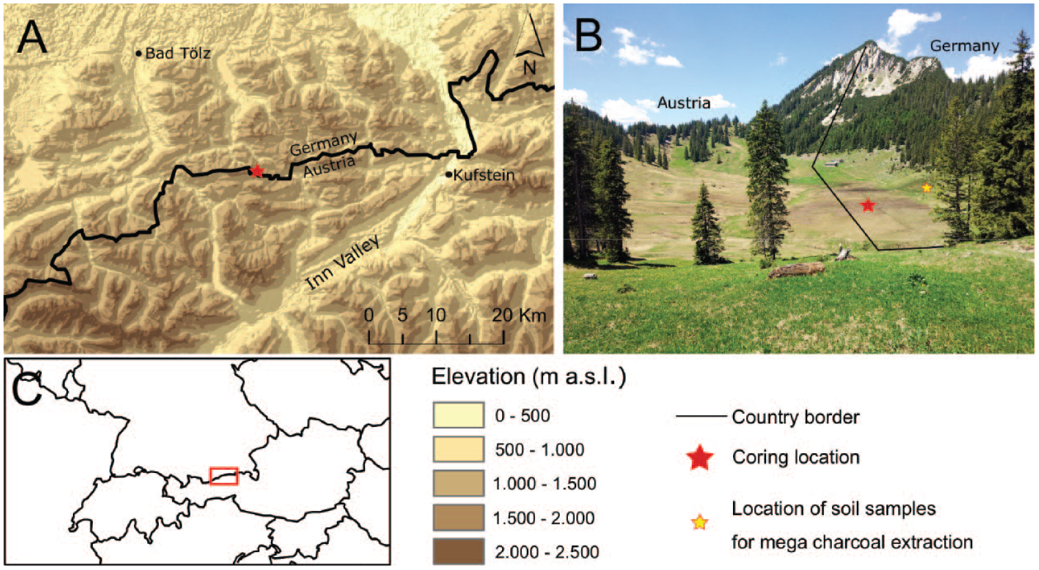
Location of the Bayerische Wildalm peatland. Source of the digital terrain model: EU-DEM v1.1 from Copernicus. Foto: F. Gilck.
Several archaeological findings from the surrounding of the study area indicate very early human activities in the region. Research from the Rofan Mountains, only 15 km south of our sampling site, reveals proof for human activities in high mountain areas beginning in the Mesolithic Age (Bachnetzer and Leitner, 2011; Kompatscher and Kompatscher, 2005; Leitner et al., 2011). Beginning in the Mesolithic Age, humans reportedly began to hunt and exploit flint stone and radiolarite deposits in the Rofan Mountains at altitudes around 2000 m a.s.l. (Bachnetzer and Leitner, 2011; Kompatscher and Kompatscher, 2005; Leitner et al., 2011). This, together with findings from the Fotschertal (Ullafelsen) south of Innsbruck, demonstrates, that Mesolithic hunters already populated the Northern Alps (Schäfer, 1998). Excavations of stone tools of northern alpine and southern alpine origin in the Fotschertal revealed, that these tools were transported via mountain pass routes over the whole Alpine ridge from the Italian to the Bavarian Alps during the Mesolithic Age (Schäfer, 1998). The excavations in the Rofan Mountains show a continuous presence of humans throughout the Mesolithic, Neolithic, Bronze, and Iron Age. Bones from goat and sheep at approximately 2000 m a.s.l. in the Rofan Mountains, dating to the Iron Age support the hypothesis for pasture development (Bachnetzer and Leitner, 2011). Further proof for the early use of mountain passes between the Inntal and the Bavarian lowlands is provided by Raetian rock inscriptions close to the Schneidjoch at 1600 m (2.5 km from our study site), which clearly prove human presence at a time around 500 BC (Schumacher, 2004). The inscriptions display raetian consecration formulas for a Father and his two sons (Schumacher, 2004). Since these inscriptions seem to have a religious context, they do not provide direct evidence for human interaction with the environment. Contrary to the Austrian side, the Bavarian side of the study area lacks substantial evidence for Mesolithic and Neolithic activities. Findings of rock engravings from another site at 1200 m a.s.l. in the vicinity of the peatland suggest human presence during the early Bronze Age (Scherm, 2012). This finding, however, has not been scientifically confirmed yet, but together with the inscriptions at the Schneidjoch indicates human presence along mountain pass routes from the Inn Valley to the German foothills of the Alps. Further evidence of prehistoric human activities on the Bavarian side of our study area is scarce and based only on single discoveries (Uenze and Katzameyer, 1972). Noteworthy is the excavation of a big ceramic vessel on the northern side of the Tegernsee, which dates to the late Bronze Age and by its size indicates settlements in the foothills of the Alps, as the transport of such a vessel seems unlikely (Heim, 2012).
Field work
On the 4th of November 2016, a fist sediment core (WA-1) was taken with a Russian-type peat corer (Belokopytov and Beresnevich, 1955) with a 6 cm wide and 50 cm long coring chamber on the Bavarian side of the peatland. A depth of 360 cm was reached. Owing to physical constraints we were not able to cover the whole depth of the mire. Therefore, another attempt was made on the 21st of September 2017, where a second sediment core (WA-2) with a length of 425 cm was taken at the identical location following the same sampling approach. Both cores were immediately wrapped in plastic and after transportation to the University of Regensburg, the cores were stored at 4°C in a cooling chamber. In the summer of 2017 two soil profiles from the direct surrounding of the peatland were taken for soil charcoal analysis. The samples were washed through a 1 mm sieve and charcoal pieces were extracted. Ten charcoal pieces were selected from a total of 165 pieces and sent to the Curt-Engelhorn-Zentrum for Archäometrie in Mannheim, Germany for radiocarbon dating.
Chronology
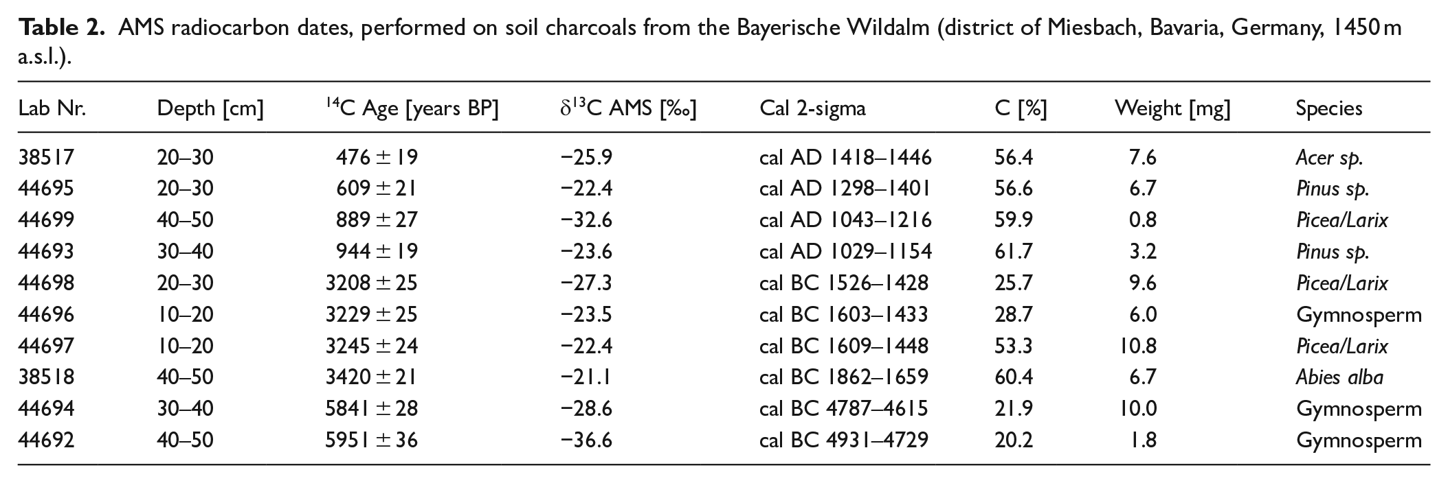
The age-depth model of the core is based on eight radiocarbon dates (Table 1) obtained from plant macro remains at selected depths from the two peat cores WA-1 and WA-2. The radiocarbon dates were measured with Accelerated Mass Spectrometry (AMS) at the Curt-Engelhorn-Zentrum for Archäometrie in Mannheim, Germany and calculated according to Stuiver and Polach (1977). Calibration of the 14C-dates took place with the software SwissCal (L. Wacker, ETH-Zürich) using the IntCal13 calibration curve (Reimer et al., 2013). The package Clam (Blaauw, 2010) within the R environment v. 3.4.0 (R Core Team, 2017) was used to calculate an age-depth model (Figure 2) based on Monte Carlo sampling with 10,000 iterations, using a smoothing spline (with a smoothing level of 0.3). According to the model, accumulation rates are very stable, varying between 12 years/cm in the upper part of the core and 27 years/cm in the lowest part of the core.
AMS radiocarbon dates performed on peat cores from the Bayerische Wildalm.
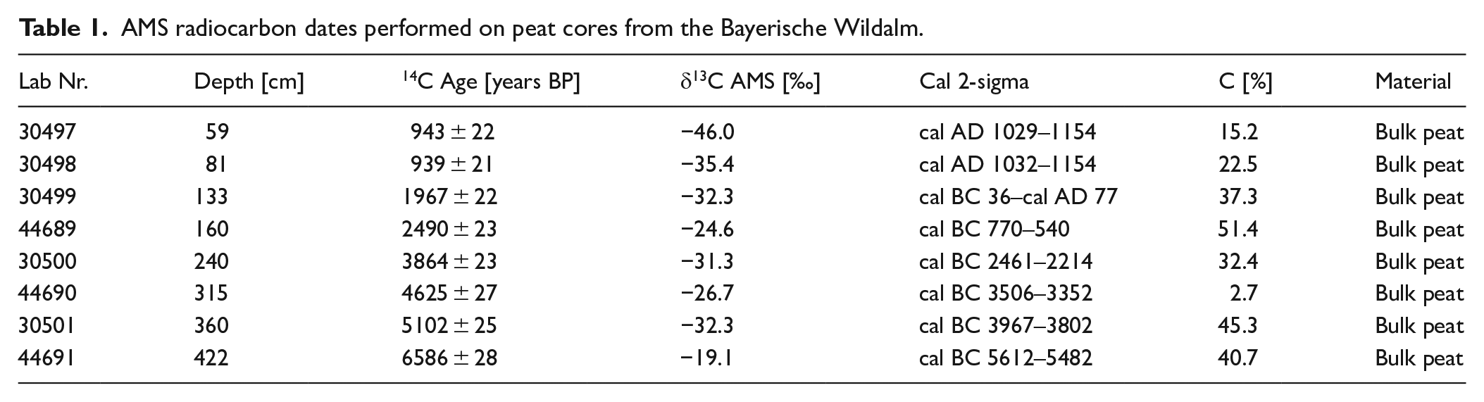
Age-depth model of the Bayerische Wildalm stratigraphy based on 14C-dating.
Palynological analysis
For the pollen analysis subsamples of the first 360 cm sediment core (WA-1) and the lowest part (360 cm–425 cm) of the second 425 cm sediment core (WA-2) were taken. Size of the subsamples was 1 cm³. In a first step subsamples from every 5–6 cm were selected and analysed. In a second step, after reviewing preliminary pollen data, areas of special importance were selected, and further subsamples were taken at these selected depths. In some parts of the core, samples from every 3 cm were analysed so that the total number of samples reached 96. Unfortunately, owing to the local occurrence of Lycopodium clavatum and Lycopodium annotinum we could not use Lycopodium spores for the calculation of concentrations and influx values (Stockmarr, 1971). The samples were treated following the standard acetolysis method (Fægri et al., 2000; Moore et al., 1991). After treatment with 10% HCl and 10% KOH, samples were sieved with 160 µm mesh size. Treatment with concentrated cold HF for 48 h prior to acetolysis was used for samples with high mineral content. Samples were mounted in glycerine. Pollen and spores were identified under the light microscope at 160×–1000× magnification, using a refence collection, as well as identification keys and pollen atlases (Beug, 2004; Fægri et al., 2000; Moore et al., 1991). A minimum of 350 pollen was counted per slide and a total of 94 pollen types was identified. The sum for calculation of pollen percentages includes trees, shrubs, and herbs, whereas spores and Cyperaceae pollen were excluded because of their possible local origin from the peatland. The definition of pastoral pollen indicators follows Behre (1981), Festi (2012) and Gilck and Poschlod (2019). Following the method of Poschlod and Baumann (2010), linear regression analysis between the most acknowledged and most used pasture indicator species, Plantago lanceolata and other potential indicator species was performed to identify further local indicator species (Table 3).
Geochemical analysis
For the geochemical analysis 96 subsamples with a size of 4 cm³ were taken from the exact depths where pollen analysis was conducted. A small part of these subsamples was pulverized, and total Carbon and total Nitrogen was measured by the Institute of Analytical Chemistry of the University of Regensburg. The remaining part of the subsamples was used to measure organic matter content of the peat using Loss on Ignition (LOI). Our protocol followed the recommendations of Heiri et al. (2001). The second heat treatment at 950°C for estimating carbonate content was left out, since it does not add information, relevant to our research questions. The samples were dried for 48 h at 75°C, weighed and then treated with 550°C in a furnace for 4 h, before being weighed again.
Statistical methods
Non-metric Multidimensional Scaling (NMDS) using Bray-Curtis dissimilarity was performed on the complete pollen dataset with the community ecology package vegan v. 2.4–5 (Oksanen et al., 2017). The pollen diagrams were constructed using the quaternary science package rioja v. 0.9–21 (Juggins, 2019). CONISS, temporally constrained hierarchical clustering (Grimm, 1987) based on Euclidean vegetation dissimilarity was used to estimate stratigraphic zones in the pollen data. The broken stick method (Bennett, 1996) was used to evaluate the number of significant stratigraphic clusters. All analyses were performed in the R environment v. 3.4.0 (R Core Team, 2017).
Results
Pollen analysis
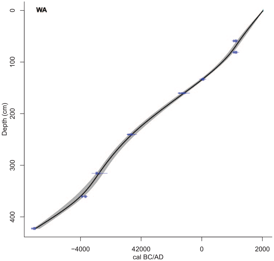
The NMDS graph partly reflects the chronology of cultural epochs and shows a correlation of the pollen spectrum with time (Figure 3). Generally, older samples from the Neolithic Age and the Bronze Age are located in the lower part of the diagram, whereas more recent samples from the Iron Age, Middle Age or Modern Times are situated more in the upper part.
Non-metric multidimensional scaling (NMDS) of the whole pollen data set from the Bayerische Wildalm peatland (district of Miesbach, Bavaria, Germany, 1450 m a.s.l.). Stress of the NMDS is 0.12. Samples are categorized according to their age and affiliation to cultural epochs.
Pollen samples dating to the early Neolithic Age form a distinct group in the lower left part of the graph and are characterized by tree species like Ulmus, Corylus avellana, and Tilia, together with aquatic and semi-aquatic plants like Potamogeton and Sparganium. Pollen samples assigned to the Neolithic Age show a wide distribution but are also located in the lower part of the graph. These samples are characterized by coniferous forest species like Picea abies, Abies alba, and Pinus. The amount of charcoal and Arboreal Pollen (AP) is also correlated to these samples. The Bronze Age samples exhibit a denser pattern and are located center-right in the NMDS graph. They are characterized by Picea abies, Abies alba and Fagus sylvatica. Samples from the Iron Age are widely distributed over the right side, many of them tending to the upper part of the graph, which correlates to pasture indicator species (e.g. Plantago lanceolata) and Non-Arboreal Pollen (NAP) such as Cyperaceae, Cereal type and Poaceae. Samples assigned to the Roman and especially the Migration Period are again located lower in the graph and are therefore characterized by typical closed forest species (Picea abies, Abies alba, Fagus sylvatica). The Middle Age and Modern Time pollen samples are clearly differentiated in the upper part of the graph and are characterized by Cyperaceae, Poaceae, Plantago lanceolata and Cereal type pollen. Additionally, Non-Arboreal Pollen are correlated to these samples.
The Broken Stick Model based on the CONISS cluster analysis identified two main pollen zones, which are subdivided to a total of eight significant subzones (Figure 4). The first main pollen zone, LPAZ 1 ranges from 5500–2100 BC and is characterized by a high abundance of tree pollen (>80%), with strongly changing proportions of the different taxa over time. LPAZ 2 is characterized by a drop in tree pollen and increases in pollen from herbaceous plant species, especially Poaceae and pasture indicator species. In the following a brief description of the different subzones is given.
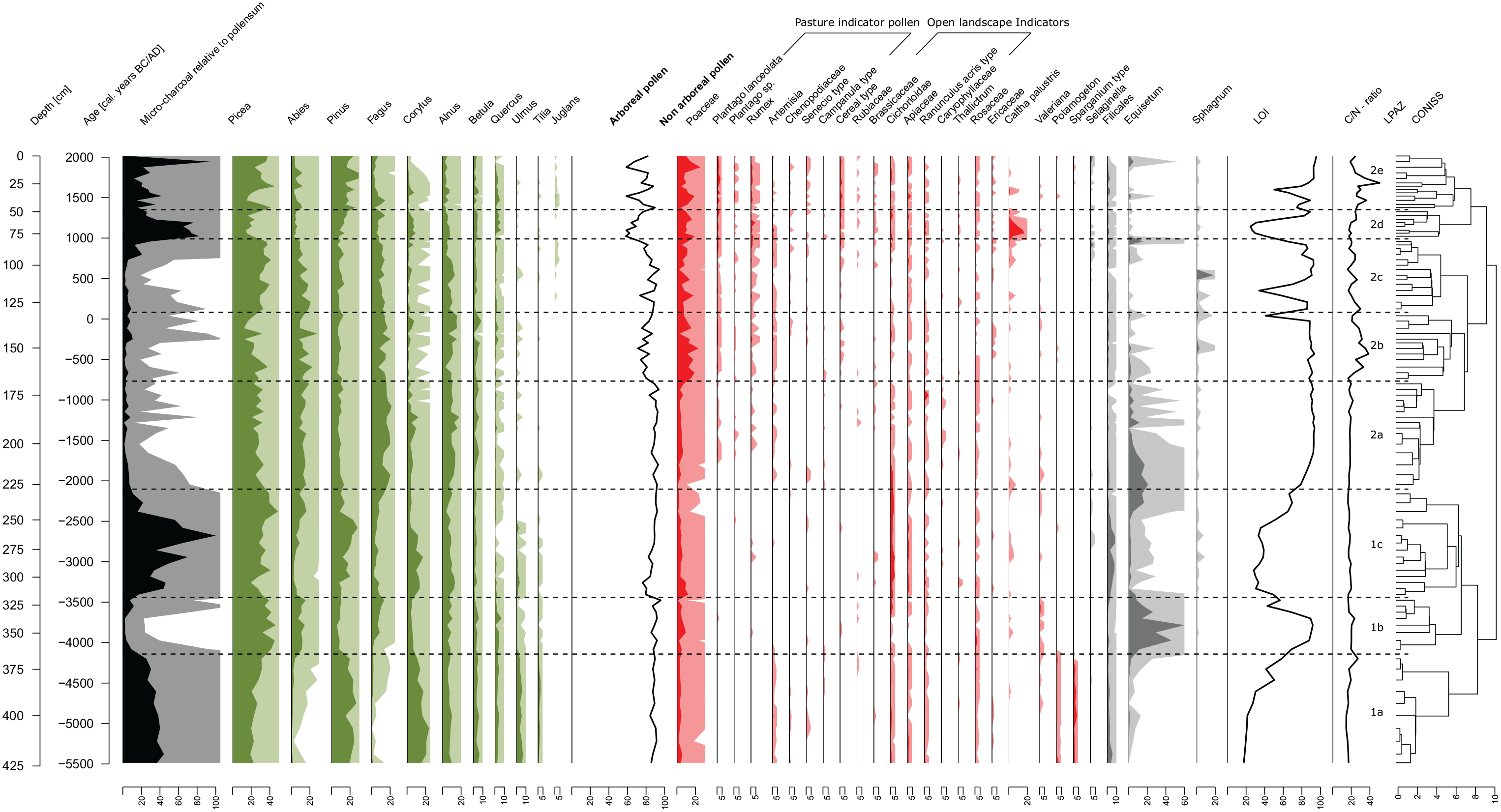
Palynological diagram for selected pollen taxa and spores from vascular plants, cryptogams as well as micro charcoal particles found in 96 peat samples from the Bayerische Wildalm peatland (district of Miesbach, Bavaria, Germany, 1450 m a.s.l.). Pollen and spore taxa are expressed as percentage values of the 100% pollen sum (excluding Cyperaceae and spores). Micro charcoals are also weighed by the 100% pollen sum and normalized to 100%. Light-color silhouettes represent a 10-fold exaggeration of the percentage values. LOI (Loss on Ignition) shows the organic matter content of the sediment core in percent.
LPAZ 1a: 5500–4200 BC, early Neolithic Age
In the lowest section of the core, Arboreal Pollen largely dominates the pollen spectrum with a share of more than 85% (Figure 4). Among them the most common pollen types are Picea abies, Pinus and Corylus avellana with appr. 20% each. Other common Arboreal Pollen types in this zone are Alnus, Betula, Quercus, and Tilia. The pollen spectrum of herbaceous species consists of aquatic or semi-aquatic plants like Potamogeton and Sparganium but also includes open landscape indicator species like Cichorioidae, Apiaceae, and Ranunculus acris type. Pasture indicator pollen are represented by Artemisia, Chenopodiaceae, Senecio type and Campanula type. The amount of micro charcoal is high in this zone with up to 0.75 charcoal fragments/pollen.
LPAZ 1b: 4200–3400 BC, middle Neolithic Age
Arboreal Pollen values remain high, or even increase to values between 85–95%. Compared to LPAZ 1a, the composition of the Arboreal Pollen taxa changes substantially. Picea abies increases up to 40% of the pollen sum, whereas the amount of pollen from Pinus and Corylus avellana decreases. Abies alba and Fagus sylvatica pollen show an increase, whereby the curve of Fagus sylvatica seems to react slightly delayed. Alnus, Betula, and Quercus do not change much, however values of Ulmus and Tilia decrease. Interestingly Poaceae pollen values show a slight increase in this zone, even though Arboreal Pollen are increasing their dominance. Open landscape indicators and pasture indicators decrease to nearly zero. Equisetum spores exhibit a very high abundance in LPAZ 1b with values close to 60% relative to the pollen sum. Micro charcoals decrease substantially to a minimum of 0.04 fragments/pollen.
LPAZ 1c: 3400–2100 BC late Neolithic Age – early Bronze Age
At the begin of LPAZ 1c the share of Arboreal Pollen drops to values below 80% and Poaceae simultaneously increase to values up to 12%. Toward the end of this zone Arboreal Pollen slowly increase back to values around 90% and Poaceae decrease to a minimum of 1%. The composition of Arboreal Pollen changes again. Abies alba and Fagus sylvatica decrease while Pinus, Corylus avellana, and to a smaller extent Alnus increase. This pattern, however, is reversed toward the end of the zone, where Abies alba and Fagus sylvatica increase and Corylus avellana and Pinus decrease again. The Picea abies pollen curve drops sharply at the beginning of LPAZ 1c but recovers to maximum values close to 50% toward the end of the zone. Ulmus and Tilia are still present at the beginning of the zone and vanish around 2500 BC. Open landscape indicator species on the contrary are increasing. Amongst them especially Cichorioidae and Apiaceae increase to maximum values of 4.5% and 1.9% in the first half of the zone. Beginning at 2800 BC, pasture indicator species like Rumex, Plantago lanceolata and Senecio type have scattered occurrences. Equisetum spores, which have very high numbers in the previous zone, decrease in this zone to nearly zero, before increasing again at the end of the zone. Simultaneous to this decrease Filicales spores increase, and the amount of micro charcoal particles reaches its maximum over the whole core with values up to 1.7 fragments/pollen.
LPAZ 2a: 2100–800 BC Bronze Age
In LPAZ 2a Arboreal Pollen remain largely dominant with a relative share around 90%. The composition of the species though changes again. Pinus and especially Picea abies decrease, whereas Fagus sylvatica and Alnus increase. Among the herbaceous species, open landscape indicators like Cichorioidae and Apiaceae, which had high abundances in the previous zone, decrease. However, pasture indicator pollen types like Plantago species and Rumex show a first continuous occurrence starting at appr. 1600 BC. Artemisia, another pasture indicator pollen type is present from the beginning of the zone. Equisetum spores are especially frequent at the beginning and micro charcoals show low values throughout the zone (mostly below 0.1 fragments/pollen).
LPAZ 2b: 800 BC–50 AD Iron Age – early Roman period
At the beginning of this zone at 800 BC, Arboreal Pollen decrease sharply from values around 90% to values below 75%. Especially Picea abies shows a strong decrease after a short initial increase. There is also a slightly negative trend for Abies alba. Other arboreal species show a more variable picture. Fagus sylvatica and Alnus curves recover after an initial decrease and the Pinus curve is stable on a comparatively low level. Amongst Non-Arboreal Pollen especially the strong increase of Poaceae pollen to values above 15% (in one sample 23%) is noteworthy. The main pasture indicator pollen types, Plantago lanceolata, Rumex, Artemisia and to a lesser extent Campanula have continuous occurrences in this zone. Cereal pollen as another indicator for human presence show an increased occurrence in this zone as well. Equisetum spores decrease after a peak in the previous zone (LPAZ 2a) and the amount of micro charcoal fragments remains low with 0.1 fragments/pollen on average.
LPAZ 2c: 50–1000 AD Roman period – Migration period – early Middle Ages
LPAZ 2c is characterized by higher amounts of Arboreal Pollen with values mostly above 85% of the pollen sum. Compared to the previous zone especially Picea abies increases strongly whereas Abies alba, Fagus sylvatica and Alnus show a slight decrease over time. Another noteworthy finding is the first occurrence of Juglans at 300 AD which consolidates around 500–600 AD. Amongst pasture indicator species, Plantago lanceolata and Artemisia show a decrease before increasing again at the end of the zone. Rumex exhibits a more indifferent pattern but also increases toward the end. Other pasture indicators and cereal pollen are nearly absent and only reappear at the end of LPAZ 2c. In the second half of the zone, beginning at 500 AD Selaginella spores show a continuous presence, and micro charcoal fragments remain on a low level before increasing slightly toward the end of this zone.
LPAZ 2d: 1000–1350 AD Middle Ages
This zone reveals the strongest drop in the share of Arboreal Pollen to values below 60%. Picea abies and Abies alba show the largest decline, whereas Pinus, Corylus avellana and, to a small extend, Quercus increase. The Poaceae curve remains high and among the pasture indicator species especially Rumex becomes more frequent. Other pasture indicator species, however, show a more scattered occurrence or even a decline (e.g. Artemisia). The cereal pollen curve is now completely closed, and open landscape indicator species show an increase compared to the previous zone. Noteworthy is also a marked peak in Caltha palustris, which reaches more than 15% of the pollen sum around 1100 AD. Micro charcoal fragments show a big increase in this zone, peaking at 1.4 fragments/pollen.
LPAZ 2e: since 1350 AD – modern period
In the most recent section of the core the share of Arboreal Pollen varies strongly with two minima of 59% around 1500 AD and around 1900 AD. In between of these two minima the share of Arboreal Pollen reaches values above 80%. These strong changes are reflected in the curves of most arboreal species as well. Especially pollen of Pinus and Picea abies vary strongly with a generally slightly increasing trend for both. Abies, Fagus and Quercus are decreasing and Juglans reaches its highest share over the whole core at 0.6% around 1400 AD. The Poaceae curve fluctuates strongly, opposite to the curve of Arboreal Pollen and reaches its maximum at 25% around 1900 AD. Among the pasture indicator pollen, Plantago lanceolata, Rumex and Senecio type have a continuous occurrence
Soil charcoal analysis
The analysis of 165 soil charcoals fragments from two soil profiles close to the peatland reveals evidence for three major fire events. The oldest one dates to the Neolithic Age with nearly 5000 BC consisting of two Gymnosperm charcoal pieces (Figure 5 and Table 2). Another four pieces date to the early Bronze Age between 1500–1800 BC. They consist of two pieces of Picea/Larix, one piece of Abies alba and one piece of Gymnosperm charcoal. The last fire event dates to the Middle Age around 1100–1400 AD and consists of two fragments of Pinus, one fragment of Picea/Larix and one fragment of Acer sp.
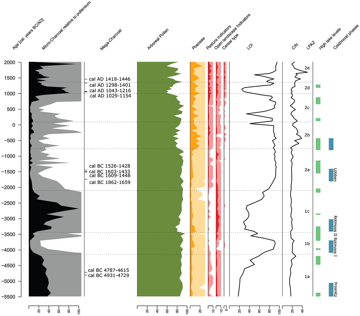
Palynological diagram for selected groups of pollen taxa. Pollen and spore taxa are expressed as percentage values of the 100% pollen sum (excluding Cyperaceae and spores). Micro charcoals are also weighed by the 100% pollen sum and normalized to 100%. Light-color silhouettes represent a 10-fold exaggeration of the percentage values. LOI (Loss on Ignition) shows the organic matter content of the curve in percent. Additional information about radiocarbon dated soil charcoal fragments is given, as well as high lake levels indicating phases with cooler climate according to Magny (2004) and cold phases inferred from glacier movements according to Patzelt (1977).
AMS radiocarbon dates, performed on soil charcoals from the Bayerische Wildalm (district of Miesbach, Bavaria, Germany, 1450 m a.s.l.).
Geochemistry
Organic matter content, measured with the Loss on Ignition method (LOI), varies greatly throughout the whole peat core (Figures 4 and 5). At the beginning, in the deepest and oldest part, it is very low with 18% but rises continuously to a maximum of 91% at 3800 BC. It decreases again quickly and reaches a low point at 3100 BC with 28%. Over the course of the next 1500 years it rises slowly and reaches 92% around 1600 BC. It remains very high, around 90%, until 50 AD, when a phase with several short minima begins with an initial minimum of 40% at 50 AD. At 300 AD, there is another very short minimum of 34% before recovering back to values around 90%. The biggest minimum is centered around 1000 AD, with 24% at 1150 AD and a subsequent rise to 88% at 1300 AD. Around 1600 AD the organic matter content falls to another local minimum of 50% before it reaches its maximum value of 95% in the uppermost part of the core. The various minima in organic matter content, especially in the younger part of the core were also visible with the bare eye as grey sandy/silty bands in the otherwise brown/black peat.
C/N-ratio starts with low values around 15 in the deepest and oldest part of the core (Figure 4). Right before the transition from LPAZ 1a to LPAZ 1b at 4200 BC it shortly rises to 27, before decreasing to around 20, where the C/N ratio remains low between 17 and 21 for 3500 years until 700 BC. At the transition between LPAZ 2b and LPAZ 2c the C/N ratio rises quickly to maximum values of 38 around 400 BC. There is a general decreasing trend with a few ups and downs for the next 800 years, with minimum values of 16. After that, the ratio increases again strongly, reaching its maximum of 50 at 1700 AD and then decreases to values around 20 at the upper end of the core.
Discussion
Pasture indicator pollen
As this research is especially aimed at identifying the begin of alpine pasturing in the Bavarian Alps, special consideration is given to the selection of pasture indicator pollen types. Pasture indicator pollen types are widely used to detect human impact on the vegetation, but only few publications are dedicated to the question of defining indicator pollen types. This causes an inconsistency in the use of pasture indicator pollen types in palynological studies across the Alps (see appendix of Gilck and Poschlod, 2019). Frequently used are the indicator pollen types defined by Behre (1981), and Oeggl (1994) for pasture indicator pollen types in an alpine environment. Festi (2012) used an experimental approach, comparing modern pollen rain with the present vegetation, to detect local pasture indicator pollen types in a montane and subalpine environment. Still, the selection of suitable indicator pollen types for our study poses difficult for several reasons.
First, many typical pasture plants for subalpine and alpine pastures are summarized in large groups because morphological differentiation of the pollen to species level is difficult or impossible. Examples for these are Ranunculus type, Cichorioidae, Brassicaceae, Apiaceae, and others. This entails the problem, that these groups, besides typical pasture plants, often include species which are not typical for open pastures. Yet, many of these pollen types are used in palynological studies at subalpine and alpine elevations as pasture indicator pollen (e.g. Drescher-Schneider, 2009; Oeggl et al., 2005; Röpke et al., 2011; Wick et al., 2003; for more see appendix of Gilck and Poschlod, 2019). Because of the abovementioned problem we decided against the use of these groups as pasture indicator pollen types (with the exception of Chenopodiaceae, which in the Alps are an ecologically very homogeneous group and generally accepted as a good pasture indicator pollen type). We, however, included most of these groups in another, broader category as open landscape indicators, because a majority of the plant species in these groups are inhabitants of open landscapes and they are generally regarded as indicators of human impact in the Alps (Oeggl, 1994).
Another difficulty with the identification of pasture indicator pollen types are the different pollination systems and differences in pollen production of plants. Owing to insect pollination and low pollen production, many typical pasture indicator species are strongly underrepresented in pollen records, which makes them unsensitive indicators for small scale changes. Wind pollinated pasture species on the other hand have the disadvantage, that they are potentially of a regional source, which makes local landscape changes difficult to assess (Brun, 2011). Nevertheless, wind pollinated pasture species with a high pollen production such as Plantago, Rumex, Artemisia, or Chenopodiaceae are the most popular and most used pasture indicator species in palynological studies in the Alps because of their strong representation in pollen records (see Appendix Gilck and Poschlod, 2019). Therefore, we decided to include them into the selection of pasture indicator species in this study as well. Campanula type was included following the suggestions of Oeggl (1994) and especially Festi (2012), who found this pollen type indicative of subalpine meadows and pastures.
The regression analysis performed with the most acknowledged pasture indicator species Plantago lanceolata and other potential pasture indicators confirms the abovementioned selection of pasture indicator species (Table 3). Additionally, it shows, that Senecio type might also be a suitable pasture indicator. This group includes many plant genera typical for alpine pastures, like Antennaria, Aster, Bellis, Doronicum, Erigeron, and Homogyne. Selaginella and Ericaceae were not considered despite their correlation with Plantago lanceolata, because of their local occurrence in the peatland (Calluna vulgaris and Selaginella selaginoides are both present in the current vegetation of the peatland). Brassicaceae and Cichorioidae, which showed correlations with Plantago lanceolata as well, were excluded due the wide ecological range of their species. One shortcoming of this regression analysis, however, is that Plantago lanceolata is considered to be an archaeophyte (Kühn and Klotz, 2002). Pokorna et al. (2018) in a study in the Czech Republic for example show, that Plantago lanceolata was introduced during the late Neolithic to Early Bronze Age. This makes it an unsuitable pasture indicator species for the early Neolithic Age. This could be the reason why we could not find a correlation with Artemisia, which is strongly represented in our pollen record in the Neolithic Age (Figure 4).
Results of the correlation analysis of potential pasture indicator pollen with Plantago lanceolata.
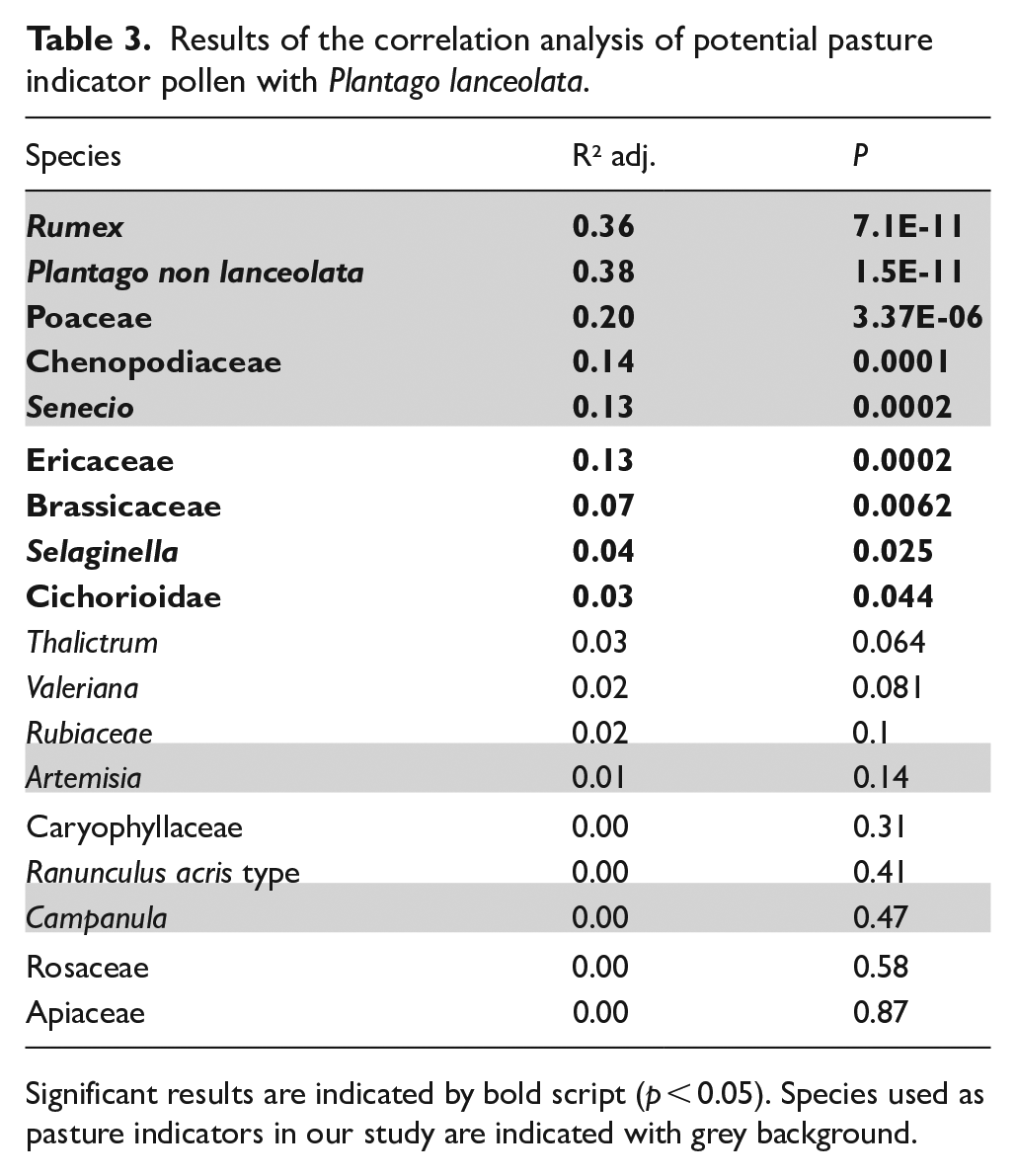
Significant results are indicated by bold script (p < 0.05). Species used as pasture indicators in our study are indicated with grey background.
As our study site and the wider surrounding is situated well below the natural tree line, the ratio between Arboreal Pollen and Non-Arboreal Pollen is also a good indicator for human impact on the vegetation since the natural vegetation at our study site is closed forest, and climate induced tree line shifts can be ruled out in the time period covered by this study.
General patterns
The results of the NMDS give a good overview over the general patterns and major changes in the pollen composition and reveal changes on three different levels. First, the development of the local vegetation in the peatland can be observed. Aquatic plants, like Potamogeton and Sparganium type in the Early Neolithic Age indicate the presence of a shallow water lake, and high amounts of Cyperaceae pollen in the more recent samples, indicate the terrestrialisation and development of a Cyperaceae-rich peatland from the lake.
Secondly, the change in forest composition becomes apparent. The change from Ulmus, Tilia and Corylus avellana in the Early Neolithic to Picea abies, Abies alba, Pinus and increasingly Fagus sylvatica in the following epochs mirrors the general development in the forest composition during the Holocene (Küster, 2010; Magri, 2008; Poschlod, 2015, 2017). Third, the strong association of the old samples with Arboreal Pollen and the more recent samples with Non-Arboreal Pollen reflects the landscape changes, from closed natural forests to a more open landscape with Plantago lanceolata, Poaceae and cereal type pollen. This indicates human impact on the vegetation with deforestation followed by pasture use and crop cultivation in the lowlands. The strong association of Corylus avellana with the Neolithic Age could be an indicator of late Mesolithic land use practices. Studies from the Southern Alps and from Northern Germany showed, that Mesolithic communities possibly used fire to promote the growth of Corylus avellana as an important forage plant (Finsinger et al. 2006; Holst, 2010).
LPAZ 1a: 5500–4200 BC, early Neolithic Age
The presence of Potamogeton and Sparganium type pollen in this layer clearly suggests the presence of a (shallow water) lake at our study site during the Early Neolithic Age. The low organic matter content values further support the idea of a small lake on mineral underground. Rising levels of organic matter content toward the end of this zone show a process of terrestrialisation of the lake and the development of a mire. The strong dominance of Arboreal Pollen suggests a closed forest landscape, however the high amount of micro charcoal and the presence of dated soil charcoal pieces at the border of the peatland are strong indicators of local fire events. As already observed in other studies (e.g. Tinner et al., 2005), this fire activity changes the forest composition with decreases of fire sensitive species like Fagus sylvatica and Picea abies and increases in Corylus avellana and Pinus (most likely Pinus mugo) (Figure 4). Since natural fires in this climate zone are rare and unlikely (Carcaillet, 1998; Müller et al., 2013) and climate reconstructions show a cooling phase until around 5000 BC (Figure 5, Magny, 2004; Patzelt, 1977), the high amount of micro- and soil charcoal could be explained by human slash and burn activities in the vicinity of the peatland. Especially the dated soil charcoals from our study site at nearly 5000 BC (Figure 5) are strong evidence for local fires. Mesolithic or Neolithic hunters could have populated the area and burned the forest in the surrounding of the peatland for hunting purposes. This theory is further supported by archaeological proof of Mesolithic hunting and mining activities in the nearby Rofan Mountains (Bachnetzer and Leitner, 2011; Kompatscher and Kompatscher, 2005; Leitner et al., 2011) and Mesolithic movements of humans across alpine pass routes (Schäfer, 1998). Another indicator for local human disturbance is the strong presence of open landscape and pasture indicator pollen types for this time (Figure 4). Especially the presence of pollen from insect pollinated plants (Senecio type, Campanula type, Apiaceae, Cichorioidae, Ranunculus acris type) suggests the local establishment of open meadow patches after disturbance by fire. These results could therefore also indicate the use of summer pastures by Neolithic settlers. Studies from the Central Alps show, that Neolithic settlers already used mountain pastures around 4500 BC with small ruminants like sheep and goat (Hafner and Schwörer, 2018; Kutschera et al., 2014). The area of the forming peatland might have been a very attractive site for early herders or hunters as it provided a naturally open area and drinking water for the animals.
LPAZ 1b: 4200–3400 BC, middle Neolithic Age
This zone is characterized by a strong increase in organic matter content, together with a strong peak in Equisetum spores, which indicates the progressing terrestrialisation and peat formation. The begin of this zone at 4200 BC coincides with the begin of the Rotmoos I glacier advances (Patzelt, 1977), and high lake levels (Magny, 2004), indicating a phase of cold and moist climate. This is reflected in the pollen diagram by decreasing curves of the warm adapted species Ulmus and Tilia. This climatic deterioration might also have triggered a decrease of human activity in the region, which is supported by very low micro charcoal values, together with a decreasing frequency of pasture and open landscape indicator pollen types (Figures 4 and 5). The decreasing fire activity is also reflected in the forest composition, where fire sensitive species such as Abies, Picea and Fagus increase and pioneer species like Corylus and Pinus (Pinus mugo) show strong decreases.
LPAZ 1c: 3400–2100 BC late Neolithic Age – early Bronze Age
The transition to LPAZ 1c at 3400 BC is marked with a drop in both, organic matter content and Equisetum spores, indicating a permanent or periodical flooding of the peatland. As the peat accumulation rate remains stable it can be assumed, that periodical flooding of the growing peatland caused the influx of mineral material into the peat. This flooding could be caused by different drivers. The Rotmoos II glacier advances (Patzelt, 1977) and high lake levels (Magny, 2004) suggest, that a climatic deterioration with higher precipitation, increased snowfall in winter and periodical flooding of the mire during snowmelt might have led to this development. This scenario gains credibility by the fact, that in recent years in cases of strong snow melt, the peatland was also temporarily flooded (Faas et al., 2007). Deforestation for hunting purposes on the slopes around the peatland could also have led to an increased water runoff, facilitating more frequent flooding events or avalanches in winter. High micro charcoal contents, together with increasing open landscape indicator pollen types show, that increasing human activities could indeed have played a role (Figures 4 and 5). The observed increase in Filicales spores could also be a reaction to fire events as many ferns profit from fire (e.g. Pteridium aquilinum). The increased fire activity is again reflected in the forest composition. Fire sensitive species (Picea, Abies, Fagus) decline, whereas pioneer species (Pinus, Corylus, Alnus) increase. The lack of dated soil charcoal pieces and the scarcity of pasture indicator pollen for this period, however, suggests, that the source of the increased micro charcoal influx is of a rather regional origin, and not caused by local fires of farmers around the peatland.
LPAZ 2a: 2100–800 BC Bronze Age
In the Bronze Age indicators of human impact on the local vegetation become more frequent. Most importantly four out of ten dated soil charcoal pieces date to this period between 1900 and 1400 BC. This is strong evidence for local fire events, possibly linked to slash and burn forest clearings around the peatland. This is further supported by an increase in pasture indicator pollen types, which show continuous presence in this zone. The increase of Alnus pollen could also be explained by human slash and burn activities in the vicinity of the peatland, since Alnus alnobetula (=Alnus viridis) is a strong pioneer plant, which profits from open landscapes and disturbance (Ellenberg and Leuschner, 2010). Increased hunting activities, or pasture use around the mire by Bronze Age farmers could be the reason for the observed changes in the pollen spectrum. This would be in agreement with many other studies, which found evidence for first pasture use at high altitudes in the Alps, beginning in the Bronze Age (e.g. Dietre et al., 2012, 2020; Drescher-Schneider, 2009; Festi et al., 2014; Mandl, 2006; Putzer et al., 2016; Walsh and Mocci, 2011; Walsh et al., 2007; Wick et al., 2003). Archaeological and dendrochronological studies from several sites in Tyrol in Austria show, that the Bronze Age was also a period of intensive copper mining in the Northern Alps (Pichler et al., 2009, 2018). Alpine pasturing, therefore, could have developed or intensified for providing mining communities in the mountains with food.
LPAZ 2b: 800 BC–50 AD Iron Age – early Roman period
The strong decrease in Arboreal Pollen at the begin of LPAZ 2b at 750 BC indicates strong human impact on the vegetation around the peatland. The amount of Arboreal Pollen drops below 75%, which according to Magny et al. (2006) and Dietre et al. (2020) represents a threshold value for open landscapes. Since the peatland is situated well below the tree line, climatic factors cannot be made responsible for these changes. Simultaneous rises in Poaceae pollen and pasture indicator pollen suggest that land use and pasturing took place in the surrounding of the peatland. Especially the presence of Campanula pollen indicates local pasturing activities, as this is an underrepresented pollen type originating from local sources only (Oeggl, 1994). The low values of micro charcoals and the lack of dated soil charcoals are evidence for only small and possibly regional fire events and could indicate that the main slash and burn forest clearings in the direct surrounding of the peatland already took place during the Bronze Age (Figure 4). The simultaneous rise in cereal pollen suggests intensified settling activities with crop cultivation in the Bavarian lowlands and the Inn valley. Some authors suggest that cereal pollen, found at higher altitudes could have been transported there also by livestock during migration to their summer pastures (Argant et al., 2006; Moe, 2014). This would add further emphasis to the suggestion of summer pastures in the direct vicinity of the peatland. Archaeological and archaeobotanical studies from the Central Alps confirm our findings by showing the begin or an intensification of alpine pasture use at higher altitudes during the Iron Age (e.g. Carrer et al., 2016; Festi et al., 2014; Haas et al., 2013; Heiss et al., 2005; Putzer, 2009). The Raethian inscriptions at the Schneidjoch at 1600 m a.s.l. close to our coring site (Schumacher, 2004) and archaeological evidence for summer farming in the Rofan Mountains above 2000 m a.s.l. (Bachnetzer and Leitner, 2011) are further proof for human activities in this area during the Iron Age and complement the results of our study very well. Another interesting feature is the sudden rise in C/N ratio at the begin of this zone after it remained very stable throughout the lower part of the core. These changes could be triggered by local disturbances in the peatland caused by intensive pasturing and local dung deposition by the grazing animals.
LPAZ 2c: 50–1000 AD Roman period – Migration period – early Middle Ages
This period is characterized by recovering Arboreal Pollen values and decreasing curves of Poaceae and pasture indicator values. This trend could be associated to the crisis and population decline during the migration period, followed by the downfall of the Roman Empire. This population decline lead to decreasing land use intensity, and since arable land and pastures were better available in the lowlands, mountain pastures became less attractive for farmers. The nearly complete absence of pasture indicators from local sources like Campanula type and Senecio type further emphasizes the decline in land use intensity. Absence of cereal pollen in the first half of this zone further demonstrates, that land use intensity also decreased strongly in the lowlands. Toward the end of this zone, in the early Middle Ages, Arboreal Pollen decreases strongly, and pasture indicators increase. This development corresponds to the increasing population density in the Middle Ages and the associated increased land use intensity (Poschlod, 2017). The first occurrence of Juglans pollen in this zone is evidence for the introduction of this species as a fruit tree by the Romans (Poschlod, 2017).
LPAZ 2d: 1000–1350 AD Middle Ages
During the High Middle Age, landscape openness reaches its maximum, which is reflected in very low Arboreal Pollen values below 60%. According to Magny et al. (2006) and Dietre et al. (2020) this is a strong indicator for open landscapes. Simultaneously pasture- and open landscape indicator pollen increase, indicating expanding pasturing activities. This corresponds well to historical information, which believes the Middle Ages to be the period in human history with the maximum of open landscape and very intensive land use, caused by a strong population growth in Central Europe (Poschlod, 2017). More evidence for increased land use intensity is provided by the results of the pedoanthracological analysis. Micro charcoals have a large peak during the High Middle Ages, indicating regional forest clearings by fire, and several dated soil charcoals from the edge of the peatland are evidence for local fire clearing activities as well. Increasing Corylus and Alnus pollen suggest disturbance, probably caused by slash and burn activities. Forest clearings and intensive pasturing in the surrounding of the peatland could have increased soil erosion, and in the case of extreme weather events, strong runoff from the slopes could have washed mineral material into the peatland. This is supported by a very high amount of mineral material in the peat during the High Middle Ages (Figures 4 and 5). Also, frequent avalanches from the surrounding slopes, caused by a lack of protecting tree cover, could transport mineral material into the peatland. The strong peak of Caltha palustris pollen around 1100 AD could be a result of these changes in the peat. The high amount of mineral material could have facilitated the strong spread of the species over the whole peatland.
LPAZ 2e: since 1350 AD – modern period
The strong fluctuations of the Arboreal Pollen curve, Poaceae pollen and pasture indicator pollen in the last period between the Late Middle Ages and modern day indicate strong changes in land use intensity, locally and regionally, around the peatland. Frequent wars and climatic deteriorations (Little Ice Age) might have contributed to declines in land use intensity. However, the closed cereal pollen curve and the high pasture indicator pollen curve demonstrate, that land use was never given up entirely in the direct surrounding of the mire and in the adjacent valleys. Several peaks in micro charcoals could be signs of more forest clearing events by fire but could also originate from burning of villages and towns during for example, the Thirty-Years’ War, since micro charcoal particles can travel large distances by wind.
Conclusion
Our study demonstrates that human interaction with the vegetation in the Bavarian Alps has a very long history. Pollen data and soil charcoal analysis revealed possible hunting or herding activities in the Early Neolithic Age above 1400 m a.s.l., which is a unique finding for the German Alps. Further signs of summer pasturing around the Bayerische Wildalm appear in the Bronze Age, with evidence for local fire clearings and subsequent occurrences of pasture indicator pollen. Very strong evidence for summer pasturing is found beginning in the Iron Age around 800 BC. Strong decreases in Arboreal Pollen, increases in pasture indicator pollen and archaeological data from the surrounding suggest intensified land use activities in the area for that time. Further changes in land use intensity, linked to population fluctuations (decline in the Migration Period, increase during the Middle Ages) are reflected very well in the pollen curves and the charcoal data. This illustrates that our multi proxy approach, using soil charcoal analysis together with palynology is a reliable method to reconstruct former land use patterns and can uncover the interaction of our ancestors with nature for time periods where written sources are unavailable.
Footnotes
Acknowledgements
We thank Josef Faas and the entire nature conservation agency (Untere Naturschutzbehörde) in the district of Miesbach for their support in finding a suitable study site, for their help in the field and for their enthusiastic support of this study. We would further like to thank Dr. Sara Saeedi (University of Regensburg), Dr. Oliver Nelle (Landesamt für Denkmalpflege, Baden Württemberg) and Dr. Morteza Djamali (IMBE, Marseille) for their support, methodological advice, and help with pollen identification. Many thanks also to Daniel Lenz for help with the geochemical analysis.
Funding
The author(s) received no financial support for the research, authorship, and/or publication of this article.