
Abstract
Northern Hemisphere cooling between 1400 and 1900 in the Common Era (CE) resulted in the expansion of glaciers during a period known as the ‘Little Ice Age’ (LIA). Early investigation of recent advances of Himalayan glaciers assumed that these events were synchronous with LIA advances identified in Europe, based on the appearance and position of moraines and without numerical age control. However, applications of Quaternary dating techniques such as terrestrial cosmogenic nuclide dating have allowed researchers to determine numerical ages for these young moraines and clarify when glacial maxima occurred. This paper reviews geochronological evidence for the last advance of glaciers in the Himalaya. The 66 ages younger than 2000 years (0–2000 CE) calculated from 138 samples collected from glacial landforms demonstrate that peak moraine building occurred between 1300 and 1600 CE, slightly earlier than the coldest period of Northern Hemisphere air temperatures. The timing of LIA advances varied spatially, likely influenced by variations in topography and meteorology across and along the mountain range. Palaeoclimate proxies indicate cooling air temperatures from 1300 CE leading to a southward shift in the Asian monsoon, increased Westerly winter precipitation and generally wetter conditions across the range around 1400 and 1800 CE. The last advance of glaciers in the Himalaya during a period of variable climate resulted from cold Northern Hemisphere air temperatures and was sustained by increased snowfall as atmospheric circulation reorganised in response to cooling during the LIA.
Introduction
The Himalaya contain the largest volume of glacier ice outside of the Arctic and Antarctic (Bolch et al., 2012). However, the drivers of recent glacier change in the Himalaya are not well constrained, and so relatively little is known about how these glaciers respond to Northern Hemisphere climate change. The ‘Little Ice Age’ (LIA) was a short-lived period of widespread cooling in the Northern Hemisphere characterised by mean annual temperature change of about −0.5°C, with lowest temperatures between 1400 and 1700 in the Common Era (CE) (Mann et al., 2009; Wilson et al., 2016) (Figure 1). The LIA represents the last advance of glaciers in Western Europe (Holzhauser et al., 2005), Iceland (Larsen et al., 2013) and North America (Luckman, 2000) (Figure 1). Glaciers in the European Alps advanced three or four times during the LIA (e.g. Schimmelpfennig et al., 2014). Advances of the largest glaciers in the Western Alps appear to have been synchronous (Holzhauser et al., 2005), but out of phase with two advances in Iceland (Larsen et al., 2013). The term ‘LIA’ is also used to describe the last advance of glaciers elsewhere in the world, for example, the Southern Alps of New Zealand (Lorrey et al., 2013) and the Himalaya (Kayastha and Harrison, 2008; Kick, 1989).
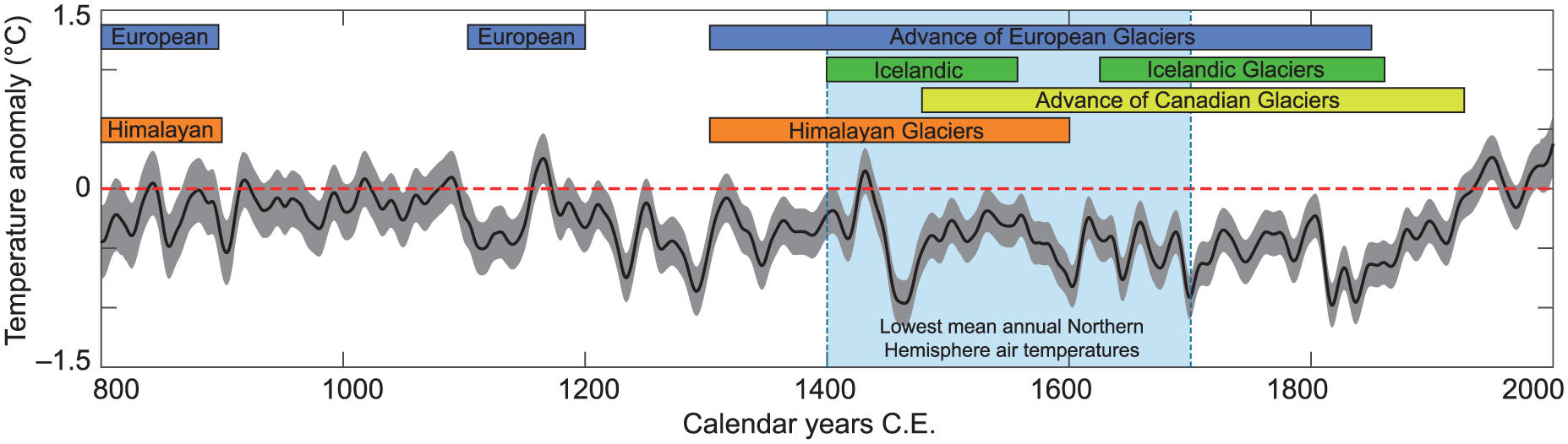
Northern Hemisphere May–August temperature anomaly for 800–2000 CE with respect to the period 1961–1990 CE produced from tree ring records filtered with a 20-year spline (black line) with 2σ uncertainties (grey shading) (Wilson et al., 2016). The vertical bar shows the period of lowest mean annual air temperatures. The bars above the black line show the timing of LIA glacier advances in the European Alps (Holzhauser et al., 2005), Iceland (Larsen et al., 2013) and North America (Luckman, 2000), and the timing of the LIA in the Himalaya inferred from this analysis of moraine ages.
Techniques such as radiocarbon (14C) dating and terrestrial cosmogenic nuclide (TCN) dating can be used to elucidate the timing of Holocene moraine formation and infer the drivers of glacier change (e.g. Schimmelpfennig et al., 2012). Glaciers in the middle and low latitudes are particularly sensitive to climate change (Oerlemans et al., 1998), and glacier change is a potentially valuable palaeoclimate proxy for the Himalaya, as many glaciers exist across a wide range of latitudes and altitudes. Only few of the Holocene moraines created by Himalayan glaciers have been dated, although sufficient ages do exist to infer when and why glaciers have changed through the Quaternary (e.g. Dortch et al., 2013; Murari et al., 2014; Owen and Dortch, 2014; Owen et al., 2009). The relatively small numbers of ages produced for LIA moraines by individual studies, and the reliance of some of these ages on applications of these dating techniques that have since been updated, means that some of these data must be treated cautiously. Bringing together all these previous studies creates a much larger and potentially more informative dataset. The reliability of each age was evaluated based on the approach used to collect samples and analyse the landform ages. This paper examines the geological evidence for the last advance of glaciers across the Himalaya to discover the timing relative to Northern Hemisphere climate change and determine the controls on glacier change. Gaps in understanding of the timing of late-Holocene advances are identified to guide future studies of the drivers of recent glacier change in the Himalaya.
Glaciers in the Himalaya
The Himalaya are a range of high mountains extending from northern Pakistan through northern India, Nepal, Bhutan and China spanning 2400 km across latitudes from 26°N to 37°N (Figure 2). The Himalaya contain a glacierised area of around 22,800 km2 (Bolch et al., 2012) composed of over 40,000 individual glaciers (GLIMS, National Snow and Ice Data Center, 2005). The Himalayan mountain range is divided into three regions – the Western Himalaya, the Central Himalaya and the Eastern Himalaya (Bolch et al., 2012). The Eastern Himalaya comprises Bhutan, the Sikkim and Arunachal Pradesh regions of India bounded by Tsangpo Gorge to the east, and part of Tibet directly to the north as far as the Brahmaputra River. The Central Himalaya includes Nepal, Uttarakhand in northern India and part of Tibet directly to the north. The Western Himalaya contains the Himachal Pradesh and Jammu regions of India, and Kashmir, extending into the easternmost part of Pakistan and Tibet to the east. Glaciers on the Tibetan Plateau are excluded from this review as their behaviour is controlled by markedly different topography and climatic regimes to those glaciers in the high mountains. The focus of this paper is on glaciers in the Himalaya, but glaciers in the Karakoram range adjacent to the Western Himalaya are included as some glacial geochronological data exist here. The Karakoram is mostly within northern Pakistan and contains the Gilgit-Baltistan region and part of Tibet to the east (Figure 2).
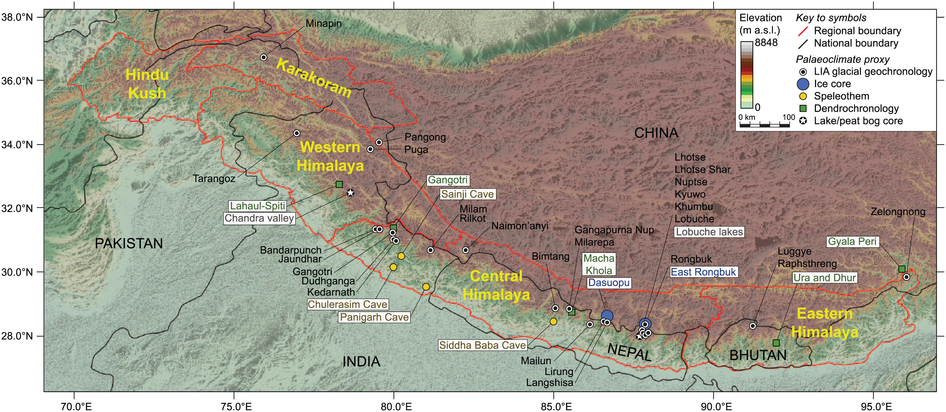
Map of the Himalaya showing the regions referred to in the text, the locations of glaciers with moraine ages assigned to the ‘Little Ice Age’ and sites of palaeoclimate proxy records that span the Common Era.
Mean glacier elevations, which can be used as a proxy for Equilibrium Line Altitude (ELA), rise from about 5200 m in the Western Himalaya to about 5600 m a.s.l. in the Eastern Himalaya (Bolch et al., 2012). Glaciers in the Himalaya have a generally negative net mass balance and are shrinking at rates that have accelerated since the 1990s (Kääb et al., 2012). Many of the large recent moraines in the Himalaya were built by debris-covered glaciers. These debris-covered glaciers have thick insulating layers of supraglacial rock debris and lose most mass by surface lowering rather than terminus recession (Benn et al., 2012; Rowan et al., 2015). As a result, many Himalayan glaciers remain close to their LIA extents at the present day, which may have misled early explorer-scientists in interpreting the state of these glaciers (as summarised by Grove, 2004).
The timing of LIA glacier advances in the Himalaya was historically inferred based on the visual similarity between recent moraines in the Himalaya and the European Alps (Grove, 2004). Some of these inferences have entered the glaciological literature without supporting geochronological data, leading researchers to debate the possibility of correlations between glacier advances in the Himalaya and Europe (e.g. Iwata, 1976). Historical records of glacier change in the Himalaya are extremely scarce. The conclusion that most glaciers in the Himalaya have been receding since 1850 CE is based on observations made in the early 19th Century and without the availability of geochronological data to constrain the timing of advance or recession (as summarised by Mayewski and Jeschke, 1979). The limitations of these historical records of glacier change in the Himalaya are summarised by Kick (1989), who noted an apparently large variation in the timing of the onset of glacier recession in the Himalaya compared with the European Alps. Kick (1989) estimated the onset of recession in the Himalaya as ‘anywhere between the beginning of the 19th Century and the beginning of the 20th [Century]’. This interpretation is based on observations made at that time based on the assumption that glaciers had only recently reached their observed positions.
More recently, ages for some Holocene moraines in the Himalaya were produced as part of larger studies looking at the timing of advances over much longer periods (e.g. Dortch et al., 2013; Owen and Dortch, 2014; Owen et al., 2009). The production of numerical ages removes the dependence on historical records and visual interpretations of glacier mass balance to infer glacier change, and allows the timing of the LIA to be constrained across wider geographical areas by comparison of data from different sites (e.g. Dortch et al., 2013; Murari et al., 2014; Owen and Dortch, 2014). Two sets of recent moraines occur in front of several Himalayan glaciers, such as Khumbu Glacier in Nepal, Pasu Glacier in Pakistan and Batal Glacier in Lahul, and are assigned to the LIA and a preceding late-Holocene (sometimes called ‘Neoglacial’) advance (Derbyshire and Owen, 1997). These two moraines are likely to represent an initial late-Holocene maximum followed by subsequent thickening of the glacier during the LIA constrained by this preexisting moraine to produce another crest inside the older one (Owen et al., 1996).
Numerical dating techniques applied to glacial landforms
Numerical ages are assigned to glacial landforms in the Himalaya using terrestrial cosmogenic nuclide (TCN) dating, optically stimulated luminescence (OSL) dating and radiocarbon (14C) dating. All of these techniques can be applied to produce ages with a resolution of decades to centuries for landforms generated during the Holocene period. For Himalayan glacial landforms that have been dated to the late-Holocene, the majority of ages have been produced using 14C and TCN, with only one age resulting from OSL dating. Each technique and the associated measurement uncertainties are reviewed here as applied to Himalayan glacial landforms, and uncertainty resulting from the geomorphological context of the material sampled for dating is summarised.
Radiocarbon dating
Radiocarbon (14C) dating measures the radioactive decay of 14C compared with stable carbon isotopes to determine the age of a sample in 14C years before present. This isotopic age must be calibrated against material of known age to convert the measurement into calendar years using the international calibration curve, called ‘IntCal13’ (Reimer et al., 2013). The start of the LIA is poorly resolved across a plateau in the 14C calibration curve until around 1650 CE (Reimer et al., 2013). 14C dating relies on the presence of organic carbon, particularly in the form of terrestrial plant material, in the landform under investigation for dating, which is generally scarce within glacial sediments. As glacial landforms such as moraines generally contain little organic material, the sample for 14C dating is typically taken from deposits associated with rather than incorporated into glacial sediments, for example, within an overlying soil or lacustrine deposit (Figure 3). The majority of 14C ages (30 of 37 ages) produced for glacial landforms in the Himalaya are the result of sample collection and laboratory analyses undertaken between 1960 and 1990 CE when laboratory techniques for measurement of these isotopes were less precise than at present. More recent studies have measured 14C using accelerator mass spectrometry to give greater precision in their results. In every case, only one sample was used to produce each age, that is, each age was not calculated from a set of samples to give a representative age distribution. Of these ages, 13 were produced by analysis of wood or charcoal, and the remainder from soils.
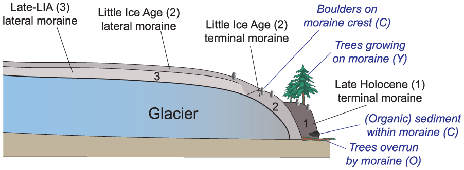
How ages produced from different materials at individual sites relate to glacier behaviour and glacier evolution where two or three moraines are present. In relation to glacier maxima, the sample age is (Y) younger, (C) contemporary or (O) older, depending on the type and location of the material sampled.
TCN dating
Terrestrial Cosmogenic Nuclide (TCN) dating measures the isotopic ratios resulting from the radioactive decay within rocks of the products formed by bombardment with cosmogenic nuclides. TCN dating of glacial landforms frequently uses 10Be extracted from quartz within individual boulders (e.g. Owen et al., 2009), although 3He from garnets was used for moraines in the Ganesh Himal (Gayer et al., 2006). TCN dating is applied to measure the exposure age of a moraine boulder by calculating the content of the isotope in question, calibration of the production rate of this isotope based on cosmogenic isotopic fluxes and topographic shielding (Heyman et al., 2016), and an estimate of the amount of erosion that the surface has undergone. Isotopic measurement uncertainties are generally low as accelerator mass spectrometry is used to make precise measurements. Ages produced using TCN dating are often calculated using statistical analysis of a population of dates for several samples collected from an individual moraine, rather than only one sample per landform. The 28 ages produced using TCN dating for moraines in the Himalaya are the result of analysis of 100 individual samples.
OSL dating
Optically Stimulated Luminescence (OSL) dating measures the timing of deposition of sediments by measuring the radiation dose produced from background radiation that has accumulated within quartz grains of the sediment itself. An advantage of OSL dating is that unlike 14C and TCN dating, this technique does not require calibration against a long-term isotopic production rate. The OSL signal is reset by sunlight, and so this technique relies on the assumption that sediments were sufficiently exposed to light during transport prior to deposition to reset the measured signal. The age of a sediment is determined by dividing the measured total radiation dose by the estimated annual dose rate. Although OSL dating has been used to date Quaternary moraine sequences in the Himalaya, only one of the ages produced relates to LIA deposits, which is measured from one sample collected from the moraine of Lhotse Glacier in the Central Himalaya (Richards et al., 2000).
Geomorphological uncertainties in geochronological sampling
Measurement uncertainties are generally low (less than 10%) for isotopic dating methods, but uncertainties in measured ages also arise from the choice of site and material sampled for dating. The strength of geochronological data relies on careful interpretation of the geomorphological setting of the sampled material, understanding of the processes that created the landforms under investigation and the analysis of multiple samples from each landform. All the geochronological techniques described here produce ages which have differing temporal relationships with glacier change (Figure 3). 14C dating measures the age since death of organic material collected from ancient trees or soils which either pre- or post-date glacier advance. Preserved trees and soils may be found underlying moraines, where they are assumed to be older than the advance that built these moraines, or trees may grow on the surface of moraines and post-date advances (Figure 3). TCN exposure ages from boulders contained within moraines date the amount of time for which the boulder has been exposed at the topographic surface, which is assumed to be coincident to the peak of moraine formation if the boulder is at the moraine crest. However, geomorphological processes degrade moraines after their formation and can influence the distribution of boulder ages in a manner that may not be apparent when samples are collected (Applegate et al., 2010; Kirkbride and Winkler, 2012). The collection and analysis of samples from multiple boulders within an individual moraine can reduce the likelihood of biasing the age results from collecting one sample that may be anomalously ‘old’ or ‘young’. OSL dating measures the amount of time since deposition of the sediment and therefore also requires interpretation of what the sediment in question represents. In the case of the OSL age from the terminal moraine of Lhotse Glacier, this sample was collected from a sand lens enclosed within a moraine and therefore was deposited earlier than the boulders on the moraine crest.
Glacier advances in the Himalaya since the start of the Common Era
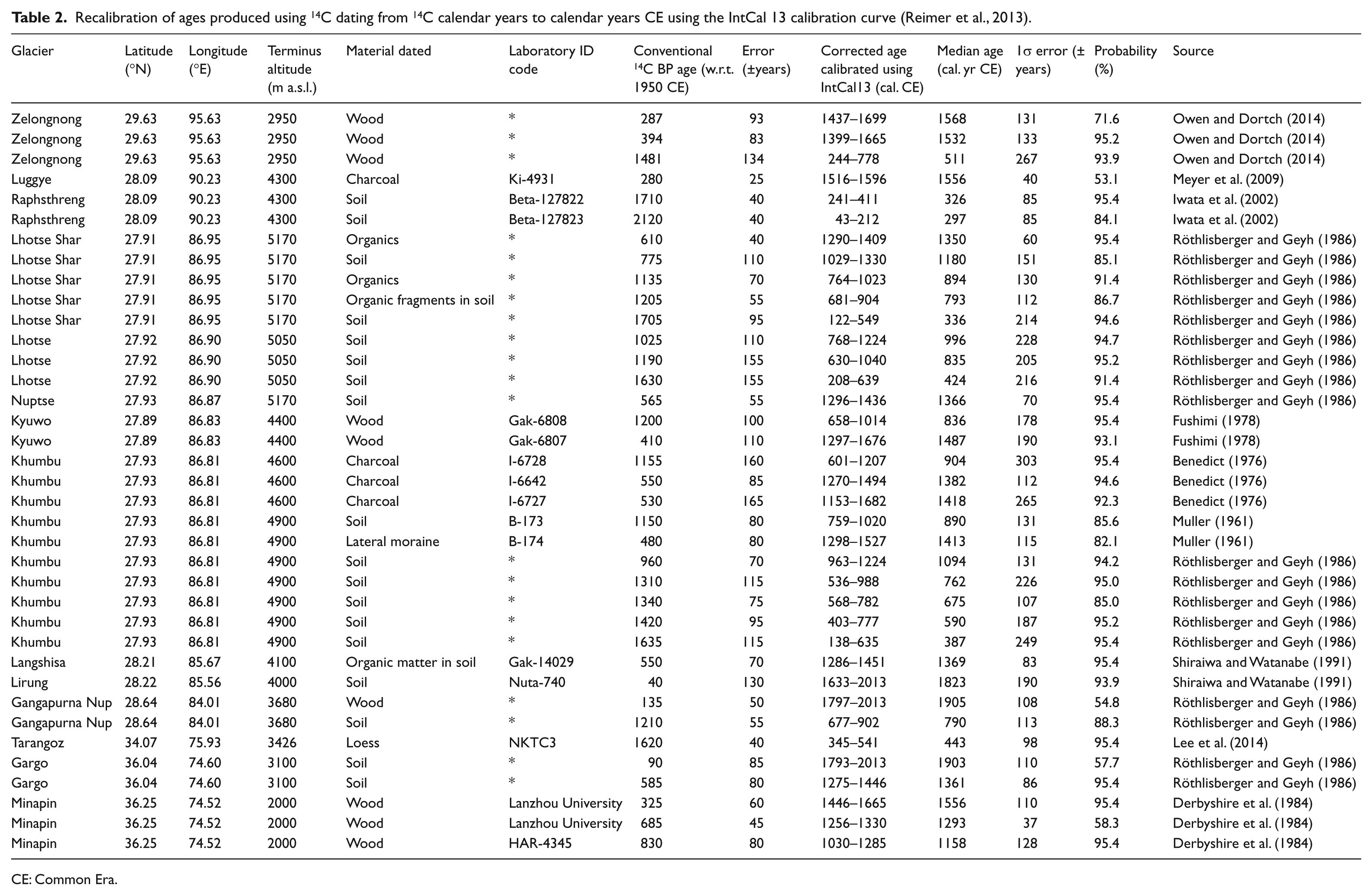
This paper reviews 66 ages from moraines and closely associated landforms indicating glacier advance in the Himalaya since the start of the Common Era (0 CE), produced from 138 samples. The moraine ages were produced using TCN dating (number of ages (n) = 28), OSL dating (n = 1) and 14C dating (n = 37) (Table 1 and Figure 4). All ages are given in calendar years CE. 14C ages were recalibrated using the OxCal program with the IntCal 13 calibration curve (Reimer et al., 2013), taking the stated 14C cal. yr BP age and the associated error to give the age of the sample in calendar years CE (Table 2). All uncertainties are given to 1σ, and the mean uncertainty across all ages presented was 16%. Where the authors did not give uncertainties for their ages, these are indicated in Table 1 and assumed to be 10% of the stated age so that these ages could be included in the compiled dataset by representing a conservative estimate similar to the mean uncertainty. A confidence level was assigned to each age to indicate the reliability of the stated age based on the method used, the number of samples collected and the geomorphological context of the sampling locations (Table 1). All samples without a stated uncertainty were given the lowest confidence level rating of 1. Geochronological data from recent moraines in the Himalaya are discussed below in the context of the region in which the glaciers are located. Data from the Eastern and Western Himalaya and Karakoram regions are few compared with those from the Central Himalaya (Figure 2).
Ages produced using a range of geochronological techniques for advances assigned to the late-Holocene and ‘Little Ice Age’ in the Himalaya. Where uncertainties are not given, these samples are marked (*).
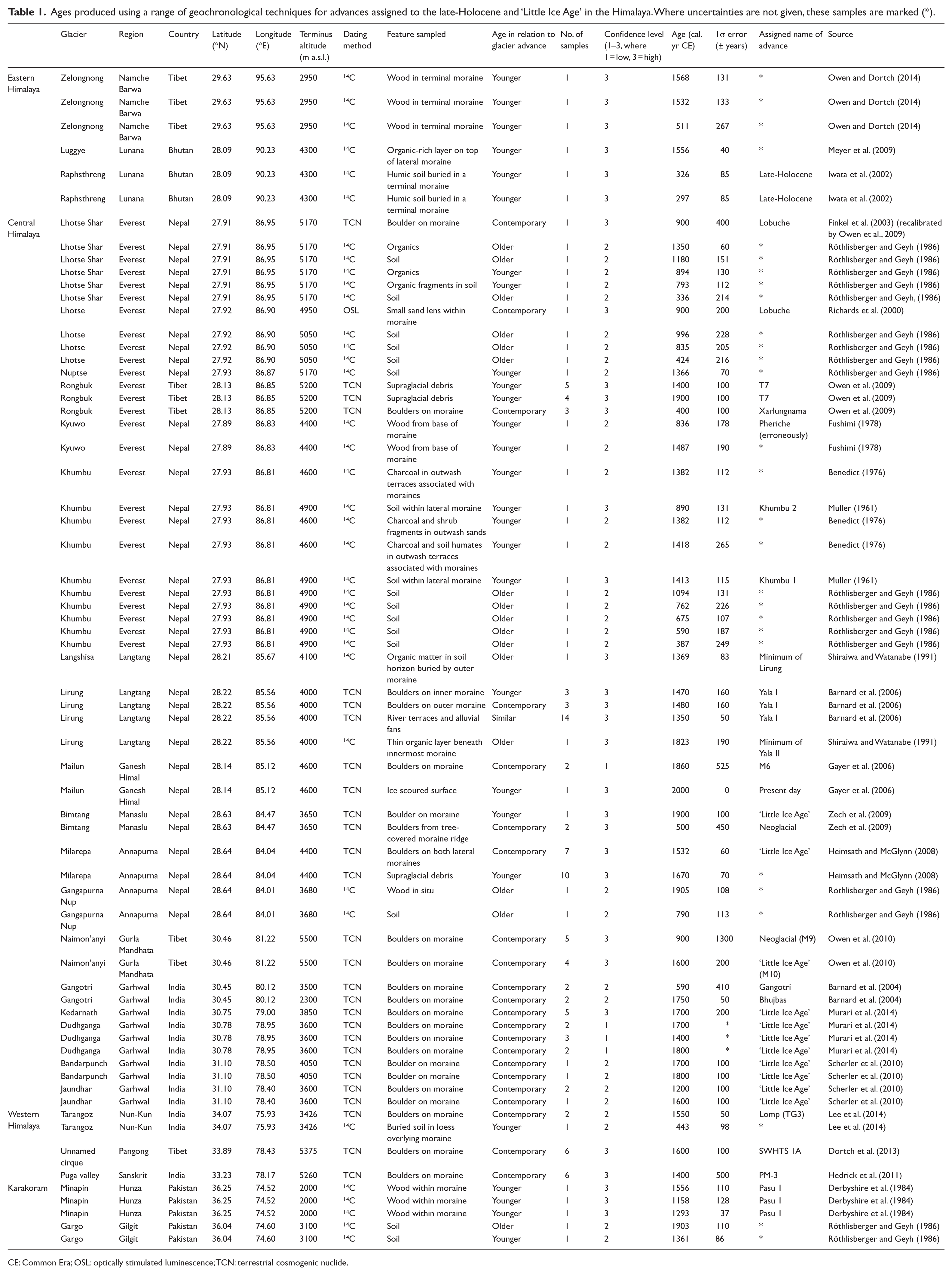
CE: Common Era; OSL: optically stimulated luminescence; TCN: terrestrial cosmogenic nuclide.
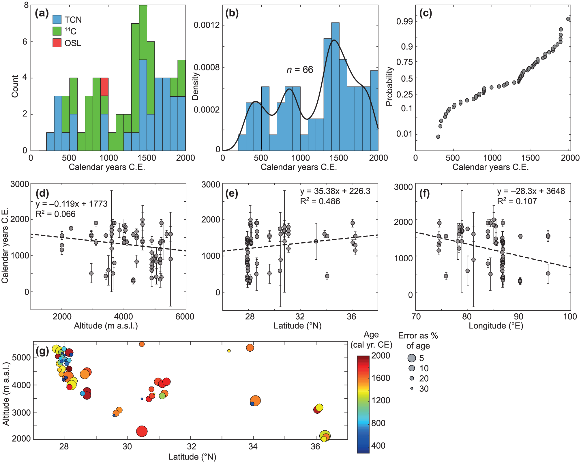
The distribution of moraine ages assigned to glacier advances during the Common Era in the Himalaya, shown as (a) a histogram count of ages with each geochronological technique represented by different colours, (b) probability density plot of ages and (c) cumulative probability of age distribution. All moraine ages plotted against (d) altitude, (e) latitude and (f) longitude, where the linear regression is weighted by the error associated with each age. (g) The distribution of all moraine ages by latitude and altitude, where the colour of the point gives the age and size of the point indicates the uncertainty associated with the age (larger points have smaller uncertainties).
Recalibration of ages produced using 14C dating from 14C calendar years to calendar years CE using the IntCal 13 calibration curve (Reimer et al., 2013).
CE: Common Era.
In some cases, more than one sample was dated to provide an age for a particular landform, giving greater confidence in the result. Applications of TCN generally use multiple samples to generate an age distribution for a particular landform, giving one representative age that captures some of the geomorphological uncertainties in the landform age. The number of samples used to calculate each age is given in Table 1, and only the one resulting age is used in calculating the timing of regional glacier change. Conversely, applications of 14C tend to use only one sample per landform, and where more than one sample is collected for the same glacier, these are often from different materials and not in close proximity, or the sample location is difficult to interpret from the information given in the publication in question. Therefore, 14C ages are presented as given by the original authors and not combined based on sampling location. The potential for bias in the resulting compiled age distribution towards the relatively greater number of 14C ages is accounted for, as for those landforms where only one sample was dated the uncertainty associated with these ages is generally higher.
Eastern Himalaya
The Raphsthreng moraines in the Lunana valley in Bhutan were dated to 241–411 CE and 43–212 CE using 14C, and assigned to the LIA (Iwata et al., 2002). However, these samples are for moraines formed by two different glaciers, and although the authors assign both ages to the LIA, they appear to have been taken from nearby but older moraines. These two sets of moraines are given an age range of 3 ka to 1900 CE, but this minimum age is an assumption about the glacial history and has not been dated (Iwata et al., 2002). Further east, two 14C ages from wood in the terminal moraines of Zelongnong Glacier in Namche Barwa in Tibet indicate a last advance around 1450 CE preceded by an earlier advance around 500 CE (Owen and Dortch, 2014). The age of the youngest moraine of Zelongnong Glacier is 1399–1665 CE which agrees with the age of 1516–1596 CE for the youngest moraine of Luggye Glacier in the Lunana valley in Bhutan (Meyer et al., 2009).
Central Himalaya
The Central Himalaya has more glacial geochronological data than other regions; 51 ages have been produced for glacial or associated landforms formed since 0 CE. In particular, the Everest region in Nepal and Tibet contains some of the best-studied moraine sequences because of relatively good access and the history of exploration here.
The Everest region
The Everest region includes the Khumbu Himal and Rongbuk Glaciers for which detailed late Quaternary geochronologies exist (e.g. Owen et al., 2009; Richards et al., 2000). Recent moraines in the Imja valley immediately to the south of Mt Everest were identified for the Nuptse, Lhotse, Lhotse Shar, Ama Dablam, Chukung, Kyuwo and Raiha Glaciers (Iwata, 1976). One age has been produced using OSL dating for a sand lens in the Lhotse Glacier terminal moraine of 900 ± 200 CE (Richards et al., 2000) and is supported by three similar 14C ages for this moraine and five from that of the neighbouring Lhotse Shar Glacier (Röthlisberger and Geyh, 1986). The moraine of Kyuwo Glacier was dated using 14C to 1014–658 CE (Fushimi, 1978), and although this moraine was assigned by Fushimi to the Pheriche advance (equivalent to the Last Glacial Maximum (LGM) around 21 ka), this age is likely to instead represent the late-Holocene advance because of the morphological similarity with the moraines dated by Owen et al. (2009).
Two sets of lateral and terminal moraines are located immediately outboard of the present-day margin of Khumbu Glacier (Figure 5). These moraines represent the last Holocene advances and have previously been grouped together as one event in the absence of geochronological data (Iwata, 1976). The outmost subdued lateral moraine ridge of large glaciers in the Khumbu Himal is assigned to a late-Holocene advance (Richards et al., 2000). The late-Holocene advance was called the Lobuche advance and dated to 900 ± 400 CE using TCN dating of one sample from the moraine of Lhotse Shar Glacier (Owen et al., 2009) and 900 ± 200 CE using OSL of one sample from neighbouring Lhotse Glacier (Richards et al., 2000). The Lobuche advance of Khumbu Glacier was also dated to 601–1207 CE using 14C applied to a soil sample collected from an outwash terrace at the base of the outer terminal moraine below Dugla village (Benedict, 1976), and five samples from nearby soil profiles gave ages around 700 CE (Röthlisberger and Geyh, 1986). The recent Xarlungnama moraines formed by Rongbuk Glacier on the northern side of Mt Everest were dated to 400 ± 100 CE from TCN dating of three samples, which is broadly synchronous with the late-Holocene advance of glaciers in the Khumbu Himal (Owen et al., 2009).
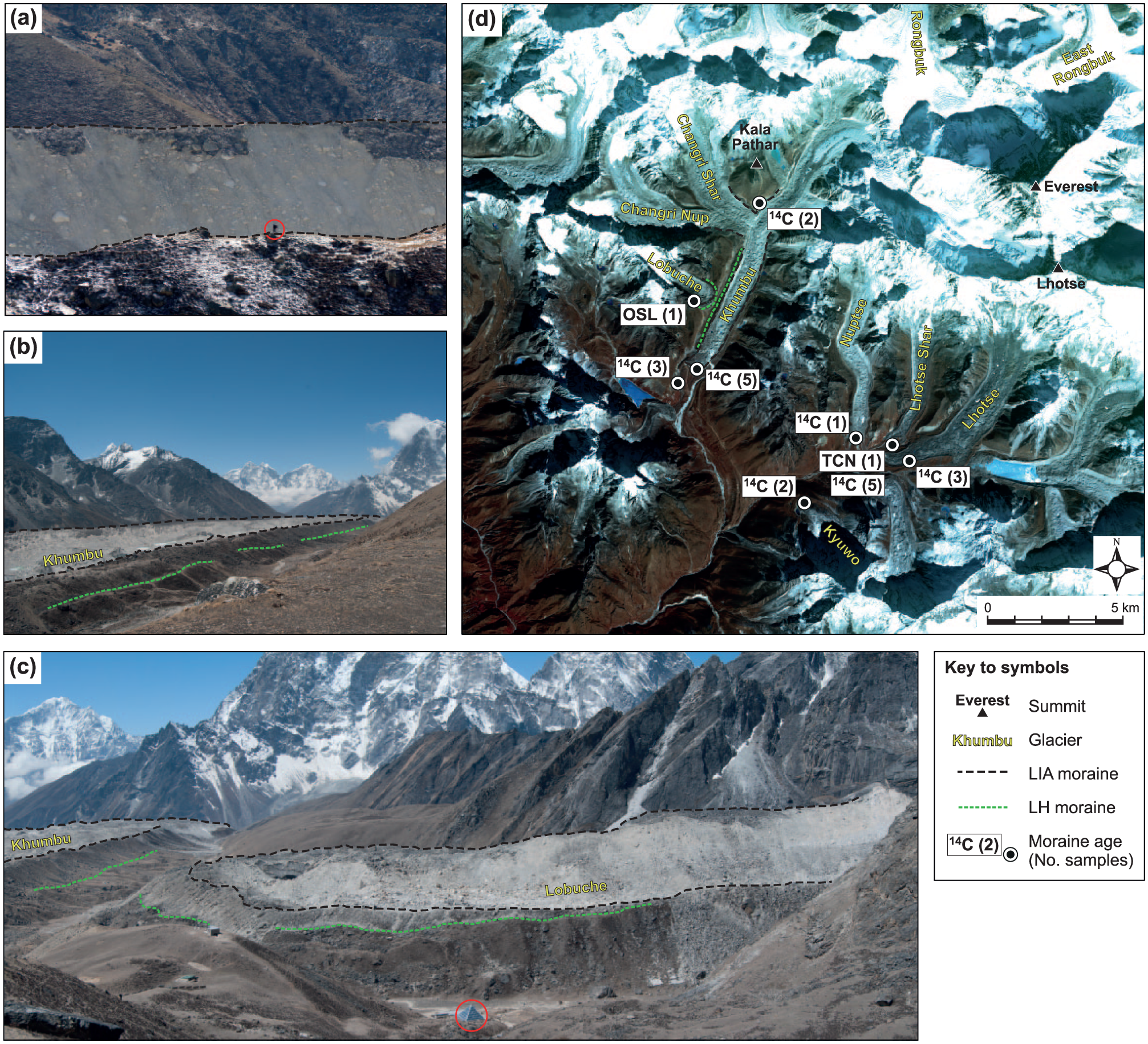
The late-Holocene (LH) and ‘Little Ice Age’ (LIA) moraines of Khumbu and Lobuche Glaciers in the Everest region of Nepal, showing (a) the left-lateral and right-lateral LIA moraine crests of Khumbu Glacier (note person circled for scale); (b) left-lateral and right-lateral LIA and right-lateral late-Holocene moraine crests of Khumbu Glacier, seen from a similar viewpoint to (a); (c) lateral and terminal LIA moraines and lateral late-Holocene moraines of Khumbu and Lobuche Glaciers (note Pyramid atmospheric research station circled for scale). (d) Summary map of ages produced for moraines the Everest region, showing the location of samples, the geochronological method used and the number of individual samples represented by each age. Ages are presented in Table 1 and taken from studies by Finkel et al. (2003) and Owen et al. (2009) using TCN; Richards et al. (2000) using OSL; Muller (1961), Benedict (1976), Fushimi (1978) and Röthlisberger and Geyh (1986) using 14C.
Inboard of the late-Holocene moraine formed by Khumbu Glacier, a soil profile at Gorak Shep lake that lies between moraine sets, was dated using 14C to 759–1020 CE and 1298–1527 CE (Muller, 1961). Two 14C ages from samples taken from an outwash terrace below Dugla village directly above that from which the older Dugla sample was collected gave ages of 1270–1494 CE and 1153–1682 CE (Benedict, 1976). The most recent moraines formed by Kyuwo Glacier were dated using 14C as 1297–1676 CE (Fushimi, 1978). These six moraine ages falling around 1500 CE are all assigned to the LIA (Benedict, 1976; Fushimi, 1978; Muller, 1961). Although younger moraines were identified by Owen et al. (2009) at the Rongbuk Glacier inboard of the Xarlungnama moraines, these have not been dated.
Western and Central Nepal
Glaciers in the Langtang region of Nepal to the west of the Everest region have mean terminus altitudes of around 4000 m, lower than those in the Everest region of 4900–5200 m (Table 1). In the Langtang catchment, two advances named Yala I and Yala II were preceded by the Lirung advance. The minimum age of the Lirung advance based on a 14C date from the moraines formed by Langshisa Glacier is 1286–1527 CE (Shiraiwa and Watanabe, 1991). TCN dating of 14 samples collected from proglacial river terraces and alluvial fans places the age of Yala I as 1350 CE. This is considered to represent the oldest age for this advance, which is assigned to the LIA, as supported by a maximum 14C age of 1450 CE, and 1480 CE from six TCN samples from boulders on the outer moraine (Barnard et al., 2006). Two 14C dates give a maximum age of 1633 CE for the Yala II moraines (Shiraiwa and Watanabe, 1991), which are assigned to the LIA as the earlier moraines are deemed too old (Barnard et al., 2006). However, based on evidence for the timing of the LIA in the Everest region of Nepal, the Yala I and Yala II ages could represent the beginning and end of the LIA advance of Lirung Glacier, as the ages are similar to those produced for glaciers in the Khumbu Himal (Benedict, 1976; Fushimi, 1978; Muller, 1961), and the climatic regime is similar. TCN ages produced for two samples from moraines in the Mailun valley in the Ganesh Himal are only constrained to between 1000 CE and the present day (Gayer et al., 2006). In the Annapurna region, seven TCN ages from the lateral moraines of Milarepa Glacier suggest an advance around 1530 ± 60 CE (Heimsath and McGlynn, 2008).
Northern India and Tibet
The Uttarakhand region of northern India includes the longest glacier in the Central Himalaya, Gangotri Glacier, and the well-studied Garhwal catchment. The foreland of Gangotri Glacier contains numerous small moraines that represent advances, locally named the Bhujbas Stage, dated using TCN to 1700–1800 CE (Barnard et al., 2004). TCN ages for moraines formed by Jaundhar and Bandarpunch Glaciers in the Tons valley gave 1400 ± 200 CE and 1700 ± 100 CE from two samples per moraine (Scherler et al., 2010). The central and western regions of Garhwal contain moraines from several glaciers including Gangotri Glacier that were assigned to the LIA using TCN dating. These results were combined with those published for other nearby moraines to assign a regional age from seven samples of 1600 ± 100 CE for the LIA in the Central Himalaya, which was preceded by periods of advance at 500 ± 200 CE and 1300 ± 100 CE (Murari et al., 2014). A well-dated moraine of Naimon’anyi Glacier in the Gurla Mandhata region of southern Tibet has an age of 700–900 CE based on TCN dating of five samples and is assigned to the LIA (Owen et al., 2010).
Western Himalaya and Karakoram
In the Nun-Kun region of India, the most recent moraine formed by Tarangoz Glacier has an age of 1550 ± 50 CE from two TCN dates produced from moraine boulders (Lee et al., 2013). Aeolian sediment overlying an older moraine formed by Tarangoz Glacier was dated using one 14C age to 345–541 CE, which represents a minimum age for the earlier advance of this glacier (Lee et al., 2013). Two ages produced using 14C for moraines in the Karakoram for Minapin Glacier in Pakistan gave 1444–1649 CE and a maximum age of 1205 CE assigned to an advance named Pasu 1, and evidence for a later advance named Pasu 2 (Derbyshire and Owen, 1997). Historical records of glacier advance in the Karakoram indicate that glacial maxima may have occurred later here than for those glaciers further east, at around 1900–1920 CE (Kick, 1989).
Summary and interpretation of glacial geochronologies
The 66 glacial landform ages presented here span the period from 0 CE to the present day (Figure 4) and include two distinct sets of moraines at many sites. Two recent periods of advance were identified: a late-Holocene advance around 800–900 CE and a LIA advance around 1300–1600 CE. The moraines representing the two advances have different geometries and can be distinguished from each other visually. The late-Holocene advance is marked by low relief, laterally extensive moraines. These moraines created a barrier to the subsequent LIA advance, such that the LIA is marked by higher relief moraines formed directly within the older landforms by glaciers that thickened rather than expanded laterally as they gained mass (Hambrey et al., 2008). The identification of these two sets of moraines gives confidence to the geochronology for these glaciers, as where there are multiple ages they are in the correct morpho-stratigraphic order, and there is agreement between ages from the same moraine produced using different techniques. For example, the maximum age of 1205 CE for the moraine of Pasu Glacier in the Karakoram is the same feature as it is also dated as 1444–1649 CE (Derbyshire and Owen, 1997), and the age of 1200 ± 100 CE moraine of Jaundhar Glacier in the Central Himalaya corresponds to the same feature that was dated to 1600 ± 100 CE using two further TCN samples (Scherler et al., 2010). In the Khumbu valley, two clear sets of recent moraines exist for several glaciers (Figure 5), with the outer moraines dated to around 900 CE (Owen et al., 2009).
The late-Holocene advance reached a peak around 900 CE which was preceded by an earlier peak around 400 CE (Figure 4b); these two peaks represent either a spatial variability in the timing of the late-Holocene advance across the range or a drawn-out period of glacier advance and stillstand. The LIA advance occurred around 1300–1600 CE (Figure 4b). The latter part of the LIA appears to have been drawn out almost until the present day, either because of spatial variability in the timing of advance or because of ongoing moraine building during a period of stability before glacier mass loss became sustained in the 20th century. Therefore, the last advance of glaciers in the Himalaya occurred 400–700 years before the present day, representing the LIA maximum and active moraine building.
Comparing results produced using different dating methods shows a slight variation in the inferred timing between TCN (n = 28) and 14C (n = 37) ages. For the late-Holocene advances, 14C ages gives peaks at 392 and 825 CE, while TCN ages gives peaks slightly later at 495 and 887 CE. The one age produced using OSL for Lhotse Glacier gives an age of 900 ± 200 CE (Richards et al., 2000), which agrees within uncertainty with both of the possible ages for the second late-Holocene peak. The offset between results from these geochronological techniques is in agreement with the general relationship between the sample collection methods, whereby most of the 14C samples were collected from soils or organic material beneath moraines which would be older than the moraine or within moraines which would be older than the glacier maximum, whereas TCN samples were collected from boulders on moraine crests which would be expected to be contemporary to the last phase of moraine building (Figure 3). A similar offset occurs for the LIA advance, with 14C giving a peak at 1422 CE and TCN giving a peak at 1649 CE. If only those ages produced using all techniques and assigned a maximum confidence level of 3 (Table 1) are considered (n = 35), then the three peaks in the moraine age distribution occur at 392, 887 and 1525 CE.
The 66 ages used to calculate the timing of the LIA are mostly taken from glaciers in the Central Himalaya, with the exception of eight glaciers in other Himalayan regions, such as Minapin Glacier in the Hunza valley in the Karakoram, Tarangoz Glacier in India in the Western Himalaya and Zelongnong Glacier in Tibet in the Eastern Himalaya. The LIA ages are collected from sites spanning latitudes of 27.8–36.5°N, and terminus altitudes of 2300–5200 m. Moraine ages do not appear to be influenced by either altitude (R2 = 0.07) (Figure 4d) or longitude (R2 = 0.11) (Figure 4f). Moraine ages appear to have a relationship to glacier latitude (R2 = 0.49), suggesting that advances generally occurred earlier at lower latitudes (Figure 4e). However, the apparent correlations between timing of advance and glacier location may be biased by the uneven spatial distribution of sites, whereby many samples were collected in the Everest region of Nepal or the Garhwal region of India.
The end of the LIA is difficult to define, particularly as debris-covered glaciers have undergone relatively little change in their extents such that glacier tongues still occupy their LIA moraines (Figures 5 and 6) (Rowan et al., 2015). Glacier recession is ongoing throughout the Himalaya, despite the observation of anomalous recent advances in the Karakoram (Kääb et al., 2012). However, the timing of LIA moraine formation indicated by the positively skewed distribution of moraine ages (Figure 4b) suggests that glaciers remained close to their LIA maxima until the end of the 19th Century (Figure 4a–c). Two glaciofluvial samples from the proglacial area of Gangotri Glacier in the Central Himalaya dated using TCN to 1370 and 1450 CE represent deposits formed after the onset of glacier mass loss (Barnard et al., 2004). Supraglacial debris on Rongbuk Glacier dated using TCN to investigate the minimum likely age of the decline of debris transport offglacier demonstrate that sustained glacier recession occurred between 1300 and 2000 CE (Owen et al., 2009). A similar age from Milarepa’s Glacier in India from 10 TCN samples suggested that supraglacial debris was in situ since 1670 ± 70 CE (Heimsath and McGlynn, 2008).
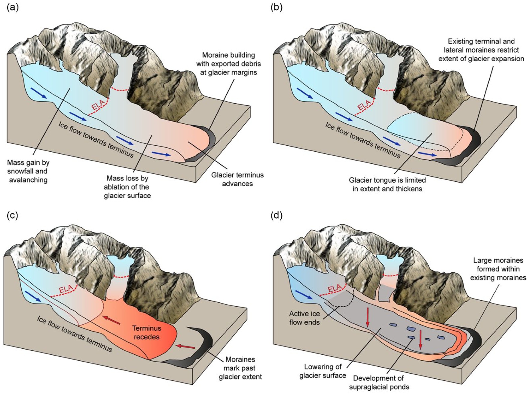
The mechanisms of glacier evolution and moraine formation by clean-ice and debris-covered glaciers during advance and recession: (a) glacier during advance, (b) glacier during advance restricted by existing moraine, (c) clean-ice glacier during recession and (d) debris-covered glacier during mass loss (recession). ELA: Equilibrium Line Altitude.
Late-Holocene palaeoclimate proxy records
Palaeoclimate data for the last 2000 years have been produced from ice cores, speleothems, dendrochronology and lacustrine sediments in the Himalaya (Figure 2). To investigate the drivers of the late-Holocene and LIA advances identified from moraine ages, these palaeoclimate proxy records are summarised here and compared with the timing of glacier advances derived from moraine geochronologies (Figure 7).
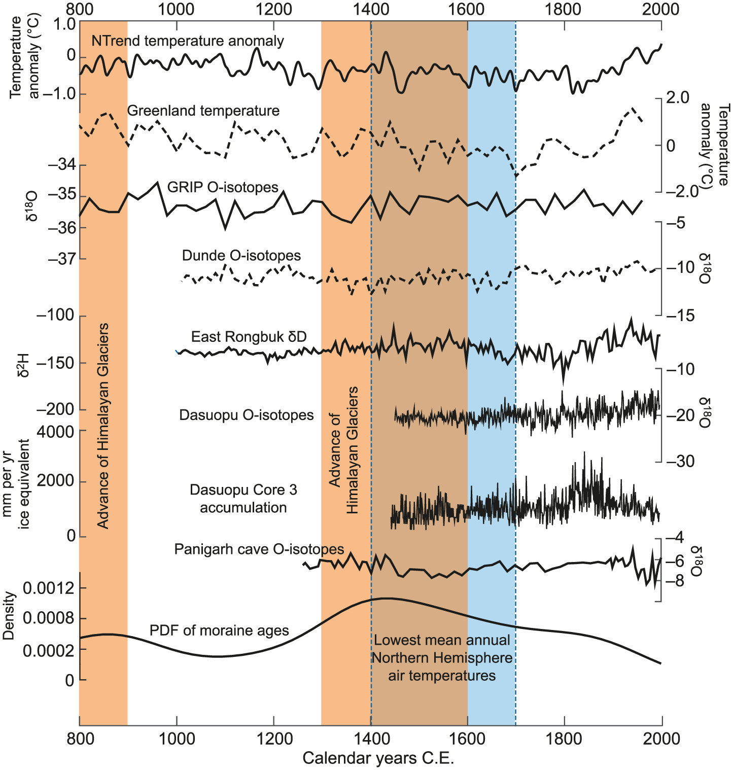
Palaeoclimate proxy data for the Himalaya from 800 to 2000 CE showing Northern Hemisphere temperature anomaly from tree ring data (NTrend; Wilson et al., 2016), Greenland temperature anomaly (Vinther et al., 2009), Greenland GRIP ice core Oxygen isotopes (Vinther et al., 2009), Himalayan ice core Oxygen isotopes from Dunde (Thompson et al., 2003), East Rongbuk (Kaspari et al., 2007) and Dasuopu Glaciers (Thompson et al., 2003), glacier accumulation from Dasuopu Glacier (Thompson et al., 2003), speleothem Oxygen isotopes from Panigarh Cave in India (Liang et al., 2015) and the distribution of all the moraine ages calculated in this study.
Ice cores
Ice cores indicate the timing of past glacier accumulation at two high-altitude sites in the central Himalaya; Dasuopu Glacier in Tibet directly north of the Langtang valley (Thompson et al., 2000) and East Rongbuk Glacier in the Everest region (Kaspari et al., 2007, 2008). Multiple ice cores were recovered from East Rongbuk Glacier at altitudes around or above 6500 m. A 108-m ice core spanning 1534–2001 CE showed that the mean glacier accumulation rate was 0.8 m ice equivalent per year between 1500 and 1600 CE, which decreased to 0.3 m ice equivalent per year around 1850 CE, then increased from 1880 to 1970 CE, and decreased again from 1970 to 2001 CE, likely controlled by monsoon precipitation (Kaspari et al., 2008). The East Rongbuk core indicates an abrupt southward shift in the South Asian monsoon around 1400 CE driven by a reorganisation of Northern Hemisphere atmospheric circulation and resulting in a reduction in precipitation at the range crest (Kaspari et al., 2007). Three cores up to 160 m in length were recovered from Dasuopu Glacier at 7000–7200 m, spanning from 1440 CE to the present with an uncertainty of ±3 years and extrapolated to 1000 CE with an uncertainty of ±5 years (Thompson et al., 2000). Decadal averaged snow accumulation from two of these cores was variable between 1400 and 1600 CE, giving values similar to those of 0.5–1.2 m water equivalent recorded from 1600 to 1817 CE. Glacier accumulation increased significantly to 1.0–1.7 m water equivalent between 1817 and 1880 CE, then gradually decreased after 1880 CE to present-day values. Increased glacier accumulation was driven by increased monsoon intensity and not redistribution by ice flow (Kaspari et al., 2008). Since 1860 CE, air temperatures and atmospheric dust content in the cores have risen, consistent with accelerating industrialisation in India and Nepal (Thompson et al., 2000). The Dasuopu core records maximum accumulation from 1880 to 1890 CE, while the East Rongbuk core shows a minimum, and it is not known whether this is because of the altitudinal difference of 700 m between these sites or regional climatic controls (Kaspari et al., 2008).
Speleothems
Speleothems collected from caves in the foothills of the Central Himalaya indicate wet and cool conditions around 1500–1850 CE, although hydrological conditions were spatially variable (Denniston et al., 2000; Kotlia et al., 2012; Liang et al., 2015). A speleothem collected from Chulerasim cave (1524 m) spanning 1590–2006 CE indicates a wet phase followed by a somewhat drier climate after 1850 CE (Kotlia et al., 2012). A nearby site 40 km to the north at Sainji Cave (1478 m) confirmed increased precipitation between 1450 and 1700 CE probably resulting from increased Westerly rather than monsoon precipitation (Kotlia et al., 2015). Another speleothem collected from Siddha Baba cave in the Pokhara valley in Nepal (~2000 m) indicated reduced monsoon precipitation between 2.3 and 1.5 ka followed by moist, cold conditions between 1550 and 1640 CE (Denniston et al., 2000). A speleothem from Panigarh Cave in Western Uttar Pradesh in India (1520 m) indicated cooler and wetter conditions between 1489–1889 CE and 1450–1820 CE (Liang et al., 2015), although the climate was warmer and drier both before and after this period, because of weakening of the South Asian monsoon (Liang et al., 2015).
Dendrochronology
Several studies of recent glacier change have been carried out in southeastern Tibet near Mt Gyala Peri in the upper Brahmaputra catchment using analyses of tree rings (e.g. Loibl et al., 2015). Although these sites are about 30 km to the north of the boundary of the Eastern Himalaya region defined by the Brahmaputra river, their results are valuable and relevant to understanding the climate of the Eastern Himalaya and so included here. Trees around Mt Gyala Peri (3780–4370 m) gave a chronology for moraines spanning 1630–1993 CE, indicating that the minimum ages for moraine formation by two glaciers were 1760–1780 CE, while a third glacier advanced around 1580, 1800 and 1870 CE (Bräuning, 2006). The age of the oldest living tree on the lateral moraine of Xinpu Glacier was calculated as 1662 CE, suggesting that moraine formation was complete by this time (Loibl et al., 2015). In the Eastern Himalaya, trees sampled at Ura and Dhur in central Bhutan (3096 and 3440 m) showed that the most pronounced cold periods of the last 600 years were from 1431–1433 CE and 1533–1535 CE, and the coldest period was 1690–1710 CE (Krusic et al., 2015). In the Central Himalaya, trees in the Macha Khola valley in Nepal indicate cold periods at 1815–1825 CE and 1900–1910 CE (Zech et al., 2003). Reconstruction of Spring temperatures between 1390 and 1987 CE from trees near Gangotri Glacier in Uttar Pradesh in India did not indicate any centennial cold excursions, suggesting that the LIA was a minor event in terms of change in Spring temperatures, and that the period 1600–1700 CE was generally warm (Yadav et al., 1999). In the Western Himalaya, temperatures inferred from tree rings in Lahaul-Spiti (3200–3600 m) showed warm summer temperatures between 1000–1100 CE and 1400–1500 CE. These warm periods were followed by decreasing summer temperatures after 1500 CE, with the 1700–1900 CE being the coldest interval of the last millennium (Yadav et al., 2011).
Lacustrine sediments
Sediment cores taken from two isolated lakes above 5000 m altitude in the Khumbu Glacier valley analysed using diatom populations indicated a cool but variable climate between 300 and 900 CE followed by climatic amelioration between 900 and 1400 CE, then a colder period between 1400 and 1900 CE (Lami et al., 2010). In the Western Himalaya, analyses of peat-lake sediment from small lake sited on a moraine from the Chandra valley in India indicated prominent cold-dry event at 1303–1609 CE (Rawat et al., 2015). On the Tibetan Plateau, analysis of the timing of lake formation and drying and the southward migration of trees and grassland indicate generally wetter-than-present conditions during the LIA, followed by drying during the 20th Century greater than at any time since 1200 CE (Putnam et al., 2016).
Discussion
Inferring the drivers of glacier change from palaeoclimate records
Observations and dating of recent moraines in the Himalaya indicate that for those glaciers with geochronological data, at least one and in some cases two advances have occurred since 0 CE. The late-Holocene advance occurred around 900 CE and may have occurred as two phases of advance with an earlier peak around 400 CE, or may represent one longer period of glacier maximum from 400 to 900 CE with few data placing moraine formation around 600–700 CE. The LIA advance in the Himalaya is more clearly constrained from the available geochronological data as a peak in moraine building around 1300–1600 CE. The drivers of glacier advance can be inferred by comparing the timing and distribution of moraine building with local and regional changes in climate over the same period observed from palaeoclimate proxy records. LIA glacier advance appears to have occurred 100 years before lowest mean annual Northern Hemisphere air temperatures (Figure 7), during a period of variable climate that led to weakening of the monsoon around 1400 CE, bringing increased winter precipitation into the Himalaya (Liang et al., 2015; Murari et al., 2014). Tree rings suggest that regional climate varied rapidly from 1000 CE, with generally cold conditions observed during 1300–1500 CE and 1800–1900 CE across the Eastern and Central Himalaya (Bräuning, 2006; Krusic et al., 2015; Loibl et al., 2015; Zech et al., 2003).
Glacier change can be directly related to climate change by considering the impact of variations in mean annual air temperatures and precipitation amount and distribution on net mass balance. However, the relationships describing the response of glaciers to climate change are not well constrained for the Himalaya, and particularly difficult to infer where thick debris layers on the surface of many glaciers also affect mass balance (Rowan et al., 2015). ELA is generally used to link glacier mass balance to regional temperature. ELA position and change in ELA may be difficult to determine for mountain glaciers that are strongly influenced by topography, particularly when they are debris-covered, although in many cases, the maximum elevation of lateral moraines can be used to estimate ELA (Benn and Lehmkuhl, 2000; Owen and Benn, 2005). Glacier–climate model simulations of ELA change from the LIA to present-day for two debris-free glaciers in the Eastern Himalaya demonstrated that sustaining these glaciers at their LIA limits required a decrease in mean annual air temperature of 1–2.5°C and an increase in precipitation of 8–25% compared with the period 2000–2012 CE (Huintjes et al., 2016). The simulated conditions for LIA ELA change are greater than the change in Northern Hemisphere temperature inferred from tree rings of −0.5°C (Wilson et al., 2016), suggesting that LIA cooling was enhanced in the Himalaya at high altitudes, and that increased winter precipitation during the LIA because of monsoon weakening also played a role in driving glacier advance (Liang et al., 2015).
Ice core records from East Rongbuk and Dasuopu Glaciers show that glacier accumulation was variable through the late-Holocene and dependent on monsoon intensity, with high accumulation between 1400 and 1600 CE, that reduced over time in the Everest region while increasing further west (Kaspari et al., 2007; Thompson et al., 2000). However, both of the sampled glaciers flow north from the range crest and are likely to experience slightly drier climate during periods of cooling as the monsoon shifted southward. These high-altitude ice cores and speleothems collected at low latitudes on the south side of the range indicate increased precipitation from 1400 CE as the monsoon moved southward, accompanied by cooler temperatures and an increase in Westerly winter precipitation (Kotlia et al., 2012, 2015; Liang et al., 2015). The late-Holocene and LIA glacier advances in the Garhwal valley in the Central Himalaya are out-of-phase with hemispheric temperature records, suggesting that these stages resulted from variations in the Westerlies (Murari et al., 2014). The LIA occurred slightly later in the Western Himalaya where the influence of the Westerlies is greater than further east. These glacier advances occurred between 1700 and 1900 CE (Yadav et al., 2011), although there is evidence from lacustrine sediments of cold conditions lasting for several centuries from 1300 CE (Rawat et al., 2015). Precipitation delivery by large regional weather systems therefore appears to be a key driver of glacier accumulation. Variability in the distribution of winter precipitation by the monsoon and Westerly weather systems occurs in response to hemispheric temperature change, implying that glacier advance in the Himalaya does not occur solely in response to cooling temperatures but is enhanced by the regional variability in precipitation distribution and timing that results from changing air temperatures across high topography.
Dating and interpretation of Holocene moraines
Early observations of the condition of glaciers in the Himalaya and their recent moraines in the absence of geochronological data led researchers to correlate the advances of Himalayan glaciers to those of European glaciers (Grove, 2004; Iwata, 1976). Historical accounts between 1850 and 1920 CE of glaciers close to their LIA extents, as indicated by lateral and terminal moraine positions, may have been misinterpreted as evidence for LIA maxima (Grove, 2004) when instead these glaciers have only undergone minor changes in area between their last advance around 1500 CE and the present day. A further limitation of these historical records is that the observation of glacier extents in the Himalaya only began around 1850 CE, so no records existed of an earlier onset of advance until the advent of numerical dating methods. For example, the advance of Kyuwo Glacier in Nepal around 1500 CE identified from a 14C age by Fushimi (1978) is unlikely to be the late-Holocene advance to which it was assigned in the absence of other geochronological data, and more likely to represent the LIA advance. Fushimi (1978) also identified another moraine at the same site as older based on its stratigraphic position, which he dated to 658–1014 CE and assigned the Pheriche (LGM) advance. However, the correlation of this advance of Kyuwo Glacier with the LGM moraines formed by larger glaciers in the Khumbu Himal is based on the interpretation of stratigraphic position, where at least three sets of moraines representing distinct advances between the LGM and LIA occur close to the terminus of the small glacier (Finkel et al., 2003). TCN ages for the Pheriche advance of neighbouring Khumbu and Lhotse Glaciers assigned the LGM to around 21 ka (Owen et al., 2009). Fushimi’s 14C sample was collected from the late-Holocene rather than LGM moraine as these features were not distinguished as separate landforms.
The development of numerical isotopic dating methods (14C, TCN and OSL) resolved some confusion resulting from attempts to correlate glacier advances in the Himalaya with each other and with those in Europe (e.g. Iwata, 1976). Numerical ages allow the comparison of the timing of moraine formation where these cannot be directly correlated in the field, and remove some of the uncertainties associated with these correlations. Advances in geochronological techniques that allow the rapid and economical production of multiple ages for individual moraines will greatly increase the scope of these correlations, particularly if initial data can be collected in the field to guide the sampling protocol (e.g. Stone et al., 2015). However, individual glaciers can respond in a different manner to the same change in climate as neighbouring glaciers in the same catchment. As such, making correlations between moraines formed by glaciers of very different sizes is challenging in the absence of geochronological data, as described above for Kyuwo and Khumbu Glaciers, and as evidenced by different but contemporaneous moraines produced by LIA advances in southeastern Tibet (Loibl et al., 2015).
Correlation of undated moraines with those for which numerical geochronological data are available, for example, between Nepal and Bhutan (Iwata et al., 2002) or between India and Pakistan (Owen et al., 1996), are tempting but unlikely to be reliable. High spatial variability in glacier change, resulting from variations in climatic regime and geomorphological setting (Kirkbride and Winkler, 2012), complicates comparisons of the timing and extent of glacier advance between regions of the Himalaya. Collecting multiple samples for dating from each moraine allows more robust ages to be generated that reflect the possibility of an age distribution influenced by surface processes and measurement uncertainties (Applegate et al., 2010). The use of multiple techniques to date moraines from a set of glaciers rather than one individual glacier means that results are likely to be more robust as uncertainties associated with the application of dating techniques to a small number of samples are reduced. The abundance of geochronological and geomorphological data from the Everest region also reduces the likelihood of uncertainties resulting from only considering the behaviour of one glacier that may not represent the behaviour of a set of glaciers in response to regional climate change.
Conclusion
Geochronological data from recent moraines formed by glaciers in the Himalaya indicate that these glaciers advanced during the late-Holocene around 900 CE (number of ages (n) = 41) and during the Little Ice Age (LIA) between 1300 and 1600 CE (n = 25) (Table 1). The timing and duration of the LIA in the Himalaya indicated by the distribution of moraine ages suggests that glacier maxima, inferred from periods of moraine building, commenced around 1300 CE, slightly earlier than the period of sustained Northern Hemisphere cooling between 1400 and 1700 CE. The end of the LIA is less clearly defined. Some moraine ages place these features in the early 20th Century suggesting stable glacier margins and ongoing moraine building until this time. Many large debris-covered Himalayan glaciers have remained close to their LIA limits until the present day, although these glaciers have lost large volumes of ice during the 20th Century by surface lowering rather than terminus recession. The onset of the LIA occurred during a period of variable climate across the Himalaya with cooling temperatures from 1300 CE. Reduced regional and Northern Hemisphere air temperatures from 1300 to 1400 CE resulted in a southward shift in the Indian summer monsoon and increased Westerly precipitation that led to greater snowfall and glacier accumulation at high altitudes. Combined with cold Northern Hemisphere temperatures, this increase in winter precipitation contributed to and may have initiated glacier expansion during the LIA.
The timing of the last two advances of glaciers in the Himalaya are calculated from 66 ages for the moraines formed by 24 glaciers using 138 geochronological samples at altitudes ranging from 2000 to 5200 m a.s.l. and mostly collected from sites in the Central Himalaya (27.8–31.1°N). The Himalaya occupy a large geographical area and there are relatively few ages for LIA moraines across the range, particularly in the Eastern and Western Himalaya. The available data indicate that, at least in the Central Himalaya region, glacier advance during the late-Holocene and LIA was widespread. The timing of the LIA varied across the Central Himalaya because of the influence of the Westerlies and monsoon. Advances occurred slightly earlier at lower latitudes, and later in the western section of the range. Glacier and catchment characteristics should be considered when comparing the timing and magnitude of advances, as factors such as glacier size, hypsometry, aspect and dynamics are likely to influence their response to climate change. The production of greater numbers of ages and collecting multiple samples for dating from each moraine are important to separate variability resulting from geomorphological processes from the climatic drivers of glacier advance. Expanding the range of sampled sites across the Himalaya and sampling multiple adjacent glaciers with different characteristics could resolve these uncertainties and better constrain the timing and drivers of the last advance of glaciers in the Himalaya.
Footnotes
Acknowledgements
A Rowan is supported by a Vice-Chancellor’s Fellowship from the University of Sheffield. Stephen Livingstone and Duncan Quincey are thanked for their helpful comments on an earlier version of this manuscript. Fuyuan Liang is thanked for providing Panigarh cave Oxygen isotope data. Two anonymous reviewers are thanked for providing constructive reviews of this manuscript.
Funding
The author(s) received no financial support for the research, authorship and/or publication of this article.