
Abstract
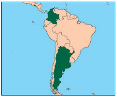
Urban governments need to take actions to reduce disaster risks and incorporate climate resilience into their development strategies and plans. But most local governments, particularly small- and medium-sized cities in the global South, lack the knowledge and capacity to do so. This paper presents the findings from a project that engaged local governments and other key stakeholders to develop a participatory planning process for climate resilient and inclusive urban development. The project took place in three small- to medium-sized Latin American cities: Dosquebradas, Colombia; Santa Ana, El Salvador; and Santo Tomé, Argentina.
By engaging government officials and politicians, academics, technical specialists, and representatives of civil society organizations in interviews, workshops and focus group discussions, this project sought to identify a range of feasible options for climate resilient and inclusive urban development. In each city, this process provided rich, context-specific details to identify strategies and plan projects with the buy-in of city government and other key actors. The overall goal was to bring in a resilience lens to assess current and planned urban development projects in each city and reach a consensus on feasible and inclusive resilience options for development.
Keywords
I. Introduction
In November 2016, three international research institutions(1) launched a project on “A participatory decision-making approach towards climate resilient and inclusive urban development in Latin America” as part of the Climate Resilient Cities in Latin America Initiative.
The primary objective was to develop and test a participatory methodology and associated tools to support cities to develop climate resilient and inclusive urban development. These were applied in three rapidly growing small- to medium-sized cities: Dosquebradas, Colombia; Santa Ana, El Salvador; and Santo Tomé, Argentina.(2)
This project came at a time when the UN’s post-2015 international frameworks (Sendai Framework for Disaster Risk Reduction, the Sustainable Development Goals, the Paris Climate Agreement and the New Urban Agenda) stressed the importance of urban areas for the future of equitable and resilient sustainable development. Local governments have very important roles in achieving equitable and resilient development, requiring a specific focus on local decision-making processes that involve all stakeholders and strengthened urban risk governance.
This project took place in Latin America, a highly urbanized region(3) and also one of the most hazard prone. The region is impacted by urban poverty, socioeconomic inequality, substandard housing and infrastructure, and inadequate institutional capacity.(4) This project sought to develop a practical way to integrate stakeholders into the decision-making process – a process that not only empowers residents, but also facilitates the implementation of strategies that contribute to resilient urban development.
While all three project cities are at risk from natural hazards and the impacts of climate change, their social and spatial urban conditions differ, providing an opportunity to assess a variety of risk reduction, climate adaptation, and resilience-building actions. The paper presents the findings from the application of the tools and methodology used during the project as well as the project outcomes, including impacts of change achieved and challenges and barriers experienced. It also considers the lessons learnt and what these suggest for applying comparable processes across other small- to medium-sized cities across Latin America.(5)
II. Methodology and Tools
This project used a methodology that brought multiple disciplines together, including social sciences (anthropological research), natural sciences (climate science and risk information), geoinformatics (decision-support tools) and urban planning. It drew on a combination of secondary data collection (mostly from government institutions), fieldwork (planning), surveys (interviews) and stakeholder workshops.
Using this multi-disciplinary approach, the project team engaged with three main questions:
1) What opportunities for climate resilient urban development and growth can the project identify through a practical participatory process, especially one that engages marginalized urban residents and reduces urban inequalities?
2) What resilience strategies can the project develop from identified opportunities?
3) How can decision-makers use the strategies identified to develop transformational urban planning and development practices for current risk reduction and climate resilient growth in selected cities?
The goal of the project was to ensure participatory planning and development processes for transformation towards inclusive and resilient development in the three cities. It was understood that to ensure this outcome, the project ought to focus on developing strategies not only for risk reduction, but also for resilience building that could lead to transformation through the strengthening of local capacities and empowerment of stakeholders.
For the purposes of this objective, the project worked with the concepts of resilience through the lenses of disaster risk reduction(6) and climate change adaptation,(7) as well as the lens of the New Urban Agenda.(8) But it also recognized that such concepts can be reinforced with the notion of transformation(9) underlining the desire to move forward from the status quo.
To ensure such transformation, the project partners worked with local teams in project cities to ensure the appropriate use of participatory methods and decision-support tools and to strengthen stakeholder capacities by “learning by doing and doing to learn”. This included the use of the QUICKScan methodology and decision-support toolbox developed by Wageningen Environmental Research (WEnR/Alterra) and the European Environmental Agency (EEA).
The QUICKScan methodology facilitated the integration of different data, knowledge bases and perspectives, and integrated the needs of stakeholders. The toolbox, based on open and flexible software and facilitation techniques, supported the exploration and assessment of different options, drawing out useful and much-needed data and information from different sources and formats during participatory workshops.
The aim of using QUICKScan was not to develop a new toolbox, but to facilitate participation of stakeholders and ease transparent exploration of options based on their needs and demands in a visual format. In this way, stakeholders could, in short periods of time (during two-day workshops), discuss what options could be useful for their city based on what had already been done and the available data and information stakeholders had.
A challenge of using the QUICKScan software and tool was the increased interest from stakeholders to learn this new tool and software, as opposed to solely using it for the workshops. During the project presentations and workshops, the project team was very clear that the aim of the workshops was not to introduce a new tool and software, but rather to start a discussion and generate a participatory planning process. In fact, a number of different participatory planning tools can be used in similar processes depending on the context, as long as such tools ensure open participation of stakeholders and are able to explore different formats of data.
The richness of the process presented in this paper lies in the way it allowed participants to: 1) create a process with stakeholders, 2) explore and validate feasible and credible options to manage climate risks and build resilience, and 3) strengthen institutional and individual capacities to integrate disaster risk reduction and resilience in municipal planning and decision making. The following section will discuss this process and how it took shape in the three project cities.
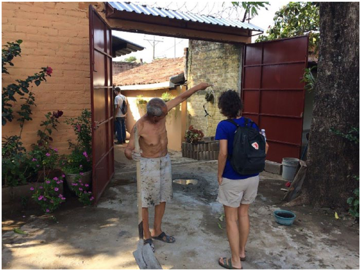
A Dosquebradas resident showing floodwater heights: “The river has not come into the houses, the houses have come into the river” (“No es el río el que se ha metido en las casas, sino las casas las que se han metido en el río”)
III. The Project Process in Three Cities
The project process had three main stages: a) stakeholder mapping and interviews, b) a workshop to explore options for climate resilient development, and c) validation of the portfolio of options and policy recommendations (Figure 1). In addition to the project phases, knowledge and information exchange took place through the Climate Resilient Cities Initiative platform and workshops, as well as a final project workshop with external resilience partners.
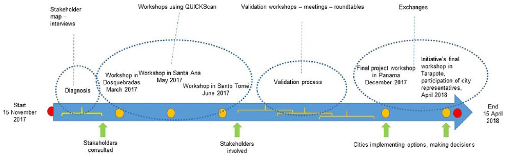
The project’s timeline
a. Stakeholder mapping and interviews
As a first step to address the project’s first question (“What opportunities for climate resilient urban development and growth can the project identify through a practical participatory process, especially one that engages marginalized urban residents and reduces urban inequalities?”), the project team developed a survey questionnaire and stakeholder maps through initial interviews with key decision-makers and local partners. The stakeholder mapping process indicated whether stakeholders were willing to share their views on the urban conditions, risks and issues facing their cities. This stage helped to identify key actors in relation to urban development and disaster risk in each city. Interviews were also useful for identifying flows of relationships and interactions, present the project to the city, and prepare the general axes (problems/opportunities) on which the dynamics of each workshop were organized. Interviews allowed the project to collect information (on land use, risks and threats, physical and social vulnerability, services and infrastructure, planned projects and other matters) that is usually dispersed across different offices. Given the gap between the production of information and its use for decision-making, the project facilitated the generation of knowledge products tailored to the needs of each city and fostered a dialogue among local actors.
b. Workshops to explore options for climate resilient development
The initial phase of stakeholder mapping, interviews, and data collection led to the second stage of the project’s participatory process, which explored opportunities for climate resilient urban development and growth. A two-day workshop took place in each city with the participation of stakeholders, who had been interviewed during the initial stage. The use of the QUICKScan toolbox and methodology in workshops facilitated the participation of all actors, as well as allowing the use of different sources of information and exploration of alternative options in a transparent and flexible manner.
The use of the QUICKScan decision mapping tool was innovative in the sense that the tool had never been used before in the realm of resilience thinking within the context of climate resilient urban development in developing countries. The innovation in this approach was to allow the cities and stakeholders to assess and explore vulnerability, risks and alternative solutions in a short period of time and consider different processes that were underway (such as in territorial zoning plans, action plans, and land use plans). It also could be combined with different types of strategies and actions (in health, environment, sanitation, transport, disaster risk reduction and other areas) that work at different time scales (short, medium and long terms), spatial scales (such as the neighbourhood, city, and metropolitan area) and decision-making levels. The tool allowed participants to bring in their ideas and combine different formats of data and information. This provided an easy-to-understand way for participants to discuss and decide on opportunities for risk reduction and resilient development, and to build a process that could continue without the experts and tools.
Stakeholders in the workshops identified and agreed on implementable opportunities. The workshops also ensured better access to information – often for stakeholders who had not been aware of such information. In particular, in Santa Ana, a half-day public conference prior to the participatory workshop ensured the wider dissemination of issues facing Santa Ana residents.
c. Validation of the portfolio of options and policy recommendations
The systematization of the information collected during the interview stage, stakeholder mapping and analysis of information, together with the results of the workshops, helped to clarify key aspects to consider for the project’s second question: “What resilience strategies can the project develop from identified opportunities?” The portfolio of options and resilience strategies were evaluated and validated according to the different government processes and demands and specific needs of each city. This stage helped to support and guide decision-making and achieve the greatest impact on public policy.
After the validation of the identified opportunities, policy recommendations were made to decision-makers. These were tied to the third question the project explored: “How can decision-makers use the strategies identified to develop transformational urban planning and development practice for current risk reduction and climate resilient growth in selected cities?”
d. Knowledge exchange and capacity development
As a final step, there was a need to develop capacities not only to deal with scaling up and down of decisions and policymaking as part of successful urban governance, but also to learn about varying options and actions for knowledge development. The project organized a city-to-city exchange workshop with the UN Office for Disaster Risk Reduction (UNISDR) Regional Office for the Americas, with the participation of other international regional initiatives of the UN Development Programme (UNDP) and 100 Resilient Cities. This workshop, held in Panama in December 2017, helped to evaluate the process; identify the next stages for the implementation of the options portfolio; share lessons learned, including the importance of integrating the knowledge and the vision of all stakeholders; and discuss how to ensure policy advocacy through changes in the governance and within the institutions. This exchange helped not only to strengthen cities’ capacities, but also to identify synergies and barriers for the implementation of the identified options. It also served to discuss how to continue supporting these cities and generate exchanges with other cities facing rapid urban growth and climate risk.
During this workshop, the three cities also signed up to the Making Cities Resilient Campaign(10) to increase their external capacities and make use of the various tools for resilience that the campaign and its partners offer.
In addition to the above-mentioned workshop in Panama, project partners and city representatives had another chance to come together in Tarapoto, Peru in April 2018, in a workshop organized by the Climate Resilient Cities in Latin America Initiative. This allowed participants to share insights and lessons learned among the six projects of the Initiative. During this workshop, the city representatives reflected on the implementation mechanisms, reviewed the process developed in their cities, and learnt from each other and other cities in the Initiative.
IV. Findings from the Three Cities
a. Dosquebradas, Colombia
The city of Dosquebradas is part of the Greater Pereira Metropolitan Area (approximately 700,000 inhabitants) and located in the coffee-growing region of Colombia, in an area of foothills and steep slopes of the Otún River Basin. The city has a population of 200,000 inhabitants, with an annual population growth of more than 2 per cent over the last 30 years. The high population growth has led to rapid urban expansion with inadequate city planning and management, and resulted in settlement and infrastructure investment in areas that are highly prone to floods and landslides. The settlement patterns increased the vulnerability of the residents and altered essential environmental services, such as those relating to the provision and regulation of water supplies.
The city also has 32 ravines, with deepening and scouring processes widening the beds. These processes are intensifying depending on the type and use of soils and the hydraulic regime of each. Of a housing stock of approximately 70,000 houses, around 4,000 to 4,500 are in risk zones. The municipality is planning to relocate 2,800 houses in risk zones. In addition, the municipality has been working to strengthen local territorial planning processes, first through the involvement in the Making Cities Resilient Campaign in 2013 and later with the ongoing development of the Territorial Plans (Planes de Ordenamiento Territorial – POT) and risk reduction strategies developed based on different risk scenarios. A key issue for the city is to address urban planning in ways that can limit disaster risk and address and support urban resilience. Lack of planning has also resulted in water stress. The city government faces an urgent need to work with over 50 water community providers to start improving and regulating water use, quality, distribution and treatment to meet increasing demands. These needs are reflected in the Local Development Plan for 2016–2019.
Against this backdrop, stakeholders were very interested in participating in interviews and the workshops for the project. The 18 participants included those from several offices from the Municipality of Dosquebradas (eight decision-makers and advisors), including from the Secretary of Agricultural Development and Municipal Environmental Management, Secretary of Planning, and Directorate of Municipal Risk Management (DIGER); civil society organizations (four managers), including the Community Association of Risk Management and Municipal Association of Community Aqueducts of Dosquebradas (AMAC); the private sector (two managers); and academic institutions and regional institutes (four researchers and advisors). These included the Technological University of Pereira (UTP) and the Regional Autonomous Corporation of Risaralda (CARDER), which became local project partners.
The workshop discussions led to seven main topics for the portfolio of actions (Figure 2):
1) Improve disaster prevention strategies together with early warning systems, education and training for the community.
2) Promote the exchange of lessons learned and good practices between institutions and cities to build capacities.
3) Develop green infrastructure to interconnect green areas to become biological corridors for the rehabilitation and strengthening of natural areas, basin protection and river margins.
4) Comply with land use norms, setting limits to urban development along creeks.
5) Generate incentives for the protection, restoration and reforestation of natural and degraded areas.
6) Increase conservation and vegetation coverage to ensure the provision, support and regulation of water supply sources for human consumption and minimize land erosion and hazards.
7) Establish an integrated plan for water management, including the use of septic tanks in rural areas and wastewater collectors and treatment in urban areas, as well as strategies to save and collect water during dry periods to reduce dependence on water provision from the nearby water-rich towns of Pereira and Santa Rosa.
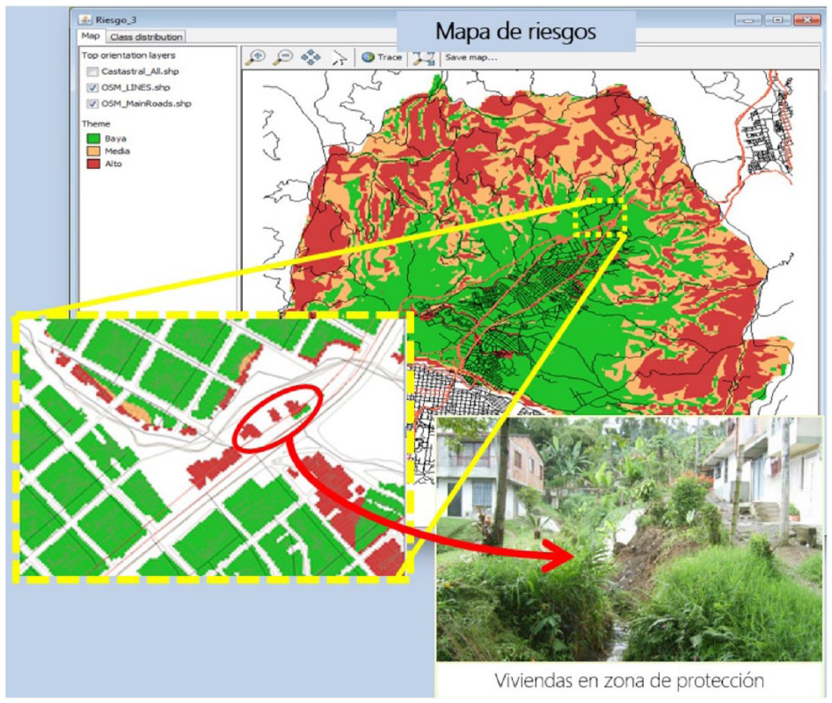
Using QUICKScan to explore risk from the city to neighbourhood level in Dosquebradas
Another important result of the workshop was the understanding that organizations held valuable information and data that were not shared with each other. Organizations that took part in the project and attended the workshop (such as municipal units, CARDER representatives, advisory commissions and NGOs) agreed to work towards the common goal of climate resilient development in Dosquebradas. This agreement was shared with a press release; and the organizations played a central part in the implementation of the project and led the validation process on the ground.
In Dosquebradas, validation took place during a follow-up workshop that sought to prioritize adaptation and mitigation measures with the officials, municipal technicians, representatives of regional institutions, and civil society partners. This led to the development of the following resilience strategies:
1) Recovery of forest and biological corridors in order to prevent and minimize threats, risks and impacts of disasters in urban expansion areas. With the increase in the coverage of forests and water sources, the supply of ecosystem services will increase and climate change impacts, particularly on infrastructure and city residents, will be reduced.
2) Development of incentives and regulations for the proper management of solid waste and the care of water resources. The objective of this strategy is to design and implement, in a pilot phase, a programme of incentives and regulations for the proper management of solid waste and the care of water resources within the municipality.
3) Strengthening and establishment of citizen oversight committees for the formulation and application of the Land Management Plan and compliance with environmental regulations in the city.
As a final step, the portfolio of options and the related actions to prioritize resilience projects were presented to the mayor and other decision-makers of the city, along with policy recommendations:
1) Provide continuity to ongoing processes to ensure the implementation of the resilience strategies. It is also important to stagger actions in other areas of the city regardless of duration, short mandates of administrative authorities, and institutional contexts and responsibilities.
2) Improve access to information on funds, financing and initiatives in order to facilitate the participation and credibility of citizens in participatory processes.
3) Integrate public policies for the reduction of risks and adaptation to climate change within long-term development plans, in order to reduce the risk of politicization, and ensure that participatory processes become a permanent deliberation process.
The project showed that stakeholders in Dosquebradas consider the exchange and sharing of information among technicians and the community to be fundamental. This facilitates the sharing of knowledge, the creation of capacities, and the articulation and implementation of actions to ensure synergies in prioritizing projects according to territorial needs and the most vulnerable sectors. The recovery of forest relicts and biological corridors in areas of urban expansion to regulate the water flow was proposed as a priority during the project. Following the presentation of policy recommendations, the City of Dosquebradas has prioritized work with community aqueducts and reforestation of hillsides.
b. Santa Ana, El Salvador
Santa Ana is the second largest city in El Salvador, with 264,091 inhabitants in 2013. It is located in the upper part of the River Lempa basin on a plateau surrounded by hillsides. The city’s problems are characterized by an expansion of low-density peripheral housing; the lack of territorial, urban and fiscal planning; the lack of integrated management of water and solid waste; and the need for emergency management, institutional strengthening and citizen communication. In addition, there is no municipal tradition of generating studies, plans and projects. Most of what is done is led by international cooperation agencies with little support for the development of local capacities. All these inadequacies in institutional management and planning make the city vulnerable to a multitude of natural hazards, including, in particular, to flood events that are amplified with climate change. The city is expanding rapidly towards the south on slopes and water recharge areas in spaces formerly used for coffee production, and with limited norms and regulations in place to control this expansion. This expansion also leads to increased flooding problems in different parts of the city, and to increased risk of landslides and problems with water provision.
In Santa Ana, 38 interviews and a focus group (with six participants) were undertaken with 14 municipal officials, 6 central government representatives, 11 academics, 6 representatives of the private sector, and 7 from civil society organizations.
The participants of the workshop that took place in May 2017 included different departments from the Municipality of Santa Ana, Civil Protection Commission, Municipal Advisors (ISDEM) and Salvadoran Community Development Association; the civil society organizations PRISMA, Un Pulmón Más, Salvation Commandos, Salvadoran Red Cross, Cruz Verde, ASAPROSAR, Association of Volunteer Camilleros, Aguilas Volunteer Lifeguards Association, APACULSA and Habitat for Humanity; the University of El Salvador; and independent professionals (Figure 3). In addition, prior to the workshop, a half-day conference introduced the subject of risk and climate resilient development to the larger public in the city.
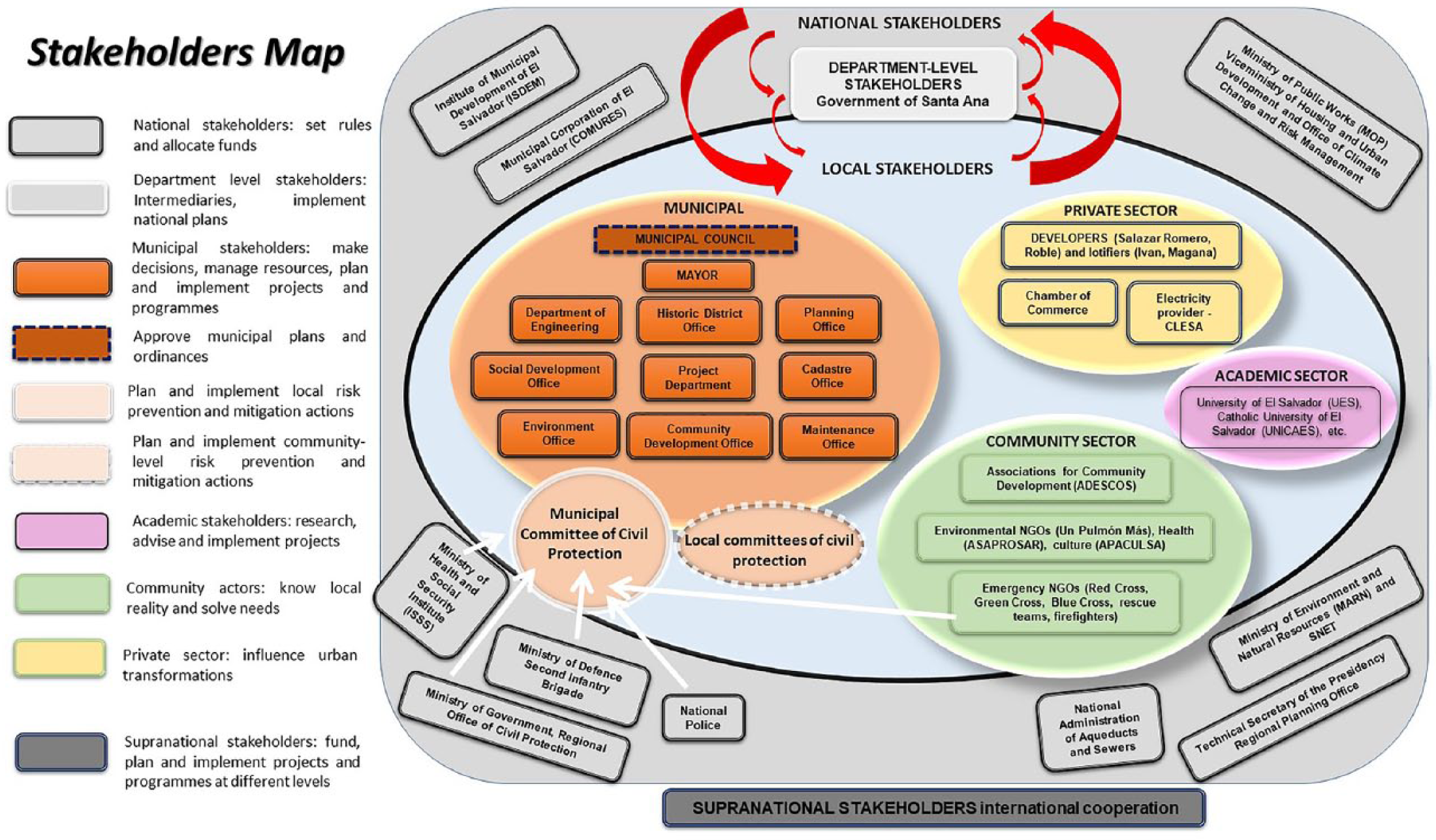
Stakeholder mapping in Santa Ana
Workshop discussions and the use of QUICKScan led to the following results:
1) Collect and share existing information, valuing the knowledge of local actors.
2) Improve the capacity of urban drainage and waste management, establishing a permanent connection between bad waste management and cultural practices leading to the obstruction of drains.
3) Protect the southern zone. Investigate the progress of large projects in process to raise options, controls and limits favouring a more resilient urban development pathway.
4) Initiate reforestation projects with native species. Work in the southern part and hills with coffee growers, residents and other citizens.
5) Strengthen public awareness and education.
One main result of the workshop was the decision to develop climate change roundtables (“mesas”) formed of stakeholders, who attended the workshop and wanted to extend the conversation on climate resilient development. The climate change roundtables were formed of officials and technicians from the municipality and civil society and were led by the project’s local partner, a civil society organization in Santa Ana, called Un Pulmón Más. Participants met several times and worked on the development of the options portfolio, created priority project cards, and then presented them to city officials and technicians. The participants of these roundtables discussed short-, medium- and long-term implementable projects based on the opportunities for climate resilient development identified in the project’s participatory workshop. This process led to the development of the following resilience strategies:
1) Flood awareness and signalling campaign in the city of Santa Ana during the rainy season. The flooding in the city of Santa Ana is in part due to the disorderly growth of the southern part of the city. This uncontrolled development has led to land use changes in the upper watersheds that increase water flows and decrease the capacities for aquifer recharge on top of soil sealing in the main urban areas, decreasing capacities for water infiltration in downtown and peri-urban zones. The objective of the project is to identify areas of greatest risk and vulnerability, and describe and collect data to establish the criteria for the development of warning signals for risks and hazards.
2) Creation of a municipal ordinance for land use, with an emphasis on the southern area of the city of Santa Ana. In recent years, floods damaged asphalt and concrete roads, particularly in the historic centre, pavements, infrastructure, and commercial premises, among other material and commercial damage. This damage is the result of the deforestation due to urbanization of the southern area of the city, an area that plays a vital role in water infiltration and regulation. The objective of the project is to establish an initial working link with the Santa Ana City Hall and develop an urban planning norm to guarantee a sustainable urban development pathway and address climate change and variability.
These strategies were presented to the city officials and technicians, and the project concluded with its policy recommendations:
1) Develop a city vision/strategic plan that includes elements of resilience: It is important to generate a commitment of continuity on the part of local governments, particularly in consideration of possible elections. Such commitment can be developed as a city vision or the strategic plan of Santa Ana. The institutional will is necessary to support this process and ensure its efficiency. In addition to the commitment of the main decision-maker, such as the mayor, it is important to have the municipal council on board, which can prioritize issues raised by the interested parties and generate a collective commitment to the problems and the execution of the resilience projects.
2) The climate change roundtable and stakeholder participation: It is suggested that the roundtables continue as a space of varied citizen participation. The participation of stakeholders, including the private sector, NGOs, academia and others, can increase empowerment in the city and facilitate the implementation of such projects. The local government should schedule quarterly and/or annual meetings with the board.
3) Reconsider reforestation and limit development activities in the southern zone; bring the private sector closer to the table and use green–blue infrastructure to increase resilience: Rapid urbanization pressure for development, leading to deforestation activities in the southern part of the city, is one of the major risk drivers in Santa Ana. It is necessary to think about development activities based on risk and inform developers and the private sector that such development will lead to long-term economic instability due to the increasing disaster risks. Low-cost reforestation activities will increase the resilience of the city.
4) Increase public awareness of the risks: Citizen education and awareness raising are key to increasing empowerment and resilience building in the city. These programmes, such as those identified in the resilience strategies, can be developed with the support of other actors, such as civil society or private sectors. Citizens should be aware that small cultural changes, such as appropriate garbage disposal, will reduce the risk of flooding in the city and will empower them by increasing their resilience capacities.
The stakeholders and participants in the project in Santa Ana have reflected that it is fundamental to create, open and maintain spaces for citizen participation, such as the climate change roundtables (given the broad response they have had), in order to strengthen the credibility of participatory processes and the exchange between actors and municipal institutions. The climate change roundtables have had a very positive impact on the social fabric of the city, leading the participants to propose that these be legalized and become a permanent “Santa Ana Climate Change Board”. The purpose of this board would be to address environmental issues affecting the city of Santa Ana, facilitating a space for participation of civil society, where participants can discuss, exchange and propose ideas and actions on these issues that can later be considered by political decision-makers.
c. Santo Tomé, Argentina
Santo Tomé is located in the centre-east of the Province of Santa Fe in Argentina. The city’s population grew 12 per cent between 2001 and 2010, almost twice the provincial average. As of 2010, it had 66,133 inhabitants, with a projected increase to 81,000 by 2025.
Santo Tomé is located at the mouth of the Salado River. It is strongly impacted by the flood regime of the river and prone to flooding. The city has developed a system of flood defences and pumping to protect itself from floods, but this is reaching the limits of its capacity. Despite a history of disaster risks and important investments in managing the flood protection system, most local actors do not perceive the city being at risk and they consider only preparedness and emergency actions. The city does not have a local disaster risk reduction plan. In addition, there is pressure on peri-urban areas to develop gated communities and no clear agreed vision on city expansion or densification options. Urban expansion without adequate risk planning and necessary infrastructure and basic services means that the city has areas that are at high risk from river floods, heavy rains, or a combination of the two, in addition to the high level of groundwater.
The city of Santo Tomé is part of the recently created Greater Santa Fe Metropolitan Area. This creates both opportunities and challenges. On the one hand, it may allow for improved comprehensive planning processes, which would make for better use of resources. On the other, it may create further dependence of smaller cities on the central city that tends to concentrate better services, employment opportunities, resources, investments and connections with other government levels. Some of these issues were discussed during the elaboration of the Base Plan(11) developed during 2013–2014, as part of a provincial strategic planning process developed with the support of United Cities and Local Governments (UCLG) and UNESCO.
The project interviewed 22 persons, of whom 8 were local government representatives, including the mayor, and representing various government areas (hydraulics, public works and services, urban planning, social development, health and environment, and others). The other 14 represented 10 institutions from civil society (4 local and regional NGOs and 6 community organizations).
The workshop that took place in June 2017 included participants from the Municipality of Santo Tomé and its different secretaries and directorates; the statistics office; a teacher training cooperative; and members of the municipal council. The neighbourhood organizations included General Paz, Sergeant Cabral and René Favaloro, and the non-governmental organizations included Terra Civil Association, Conciencia Ambiental, the Fundación Linea Verde, Fundación BICA, CÁRITAS (Parroquia Luján), Grupo Comunidad, and Centro Regional del Comercio, Industría, Agricultura y Ganadería.
The exchange and discussions during the workshop indicated the need for an information system that could be shared and for better communication between local actors. In addition, it was ascertained that the city needs to develop a disaster risk management plan and a comprehensive urban planning process, as well as the expansion and completion of infrastructure and services to reduce risks. The main issues that emerged were the need to:
1) Strengthen a comprehensive disaster risk management policy.
2) Develop a comprehensive information system of hazards, vulnerabilities and risks.
3) Improve and extend the solid waste collection system to reduce the obstruction of drains and other environmental risks.
4) Promote education campaigns and capacity building for local actors in disaster risk management, climate change and resilience issues.
5) Improve flood control infrastructure.
6) Improve urban mobility (accessibility, connections to the metropolitan area and a better transport system).
7) Improve water infrastructure and water management.
8) Explore the incorporation of green infrastructure options based on existing norms.
In Santo Tomé, the key points noted above were further developed through meetings and workshops. A workshop on “Urban Innovation: Planning and Management Instruments for Climate Change” in November 2017, co-organized with the Municipality of Santo Tomé, initiated the process of developing and implementing a local risk reduction and resilience plan. Another workshop, “Legal Analysis of Urban Instruments for Climate Change Purposes,” worked on urban policy and planning instruments for reviewing and strengthening existing systems and the organizational structure. In addition, in April 2018, a workshop on “Disaster Risk Management: Towards a Resilient Urban Development” was organized for representatives of civil society and local government. These various workshops developed within the framework of the project are helping to strengthen the local capacities of various actors to plan resilient development for Santo Tomé.
From the analysis of all the work noted above, the following resilience strategies were developed:
1) Disaster risk management and resilience: The city has been developing, strengthening and managing infrastructure works that reduce risks. This includes revising the urban drainage master plan in collaboration with the National Water Institute. The city is also starting to develop a local action plan and its subsequent implementation. The different project components described above supported the strengthening of local capacities in disaster risk management. The city government is also committed to the Making Cities Resilient Campaign guidelines, like the other two project cities of Dosquebradas and Santa Ana.
2) Infrastructure and services: Through different provincial and national programmes, the city has been managing its resources to face urgent infrastructure needs, especially sewers, urban drainage, water and pavements. It is key for the city to be able to support these works within the framework of a comprehensive project for the development of the city that aims to reduce risks and increase resilience. Therefore, a project was proposed to rethink how infrastructure work is presented and developed, together with the community. This would include working with community representatives all along the planning, implementation and maintenance phases of infrastructure projects.
3) Construction of a comprehensive and georeferenced information system: The different municipal departments face difficulties in sharing information. Each department has relevant data, but they are usually not found in compatible formats, rarely georeferenced, and not integrated into an easily accessible information base. The municipality has an agreement with the agency Spatial Data Infrastructure, Province of Santa Fe (IDESF) for training staff to assemble the system, georeference all the information, and get the support needed to operate this. Focal points within each municipal area need to be set up and their staff trained to upload information in the agreed format.
4) Comprehensive urban planning: The city does not have an agreed and shared vision. In large part, this is due to the difficulties that exist in territorial planning. There is an urgent need to advance in the development of a territorial ordering plan to guide the local development process and address its problems from an interdisciplinary perspective. Among the tasks to be addressed, it was proposed to review the “Base Plan” and its list of strategic projects, many of which are already being implemented. Technical support was provided to carry out an initial legal analysis of existing competences, policies, problems, and urban planning instruments. This clarified how the municipality could redistribute benefits. Drawing on this, it was proposed that a few of these instruments be selected and reviewed, looking at how they could have further positive impacts and how the city could make better use of them. The need to work on links and coordination “inwards” (between different areas of local government), and “outwards” (with the community), was also highlighted. This required working on communication and strengthening participatory planning processes, integrating the efforts and capabilities of all actors.
The above-mentioned resilience strategies, along with the policy recommendations below, were presented to officials and technicians of the municipality:
1) Build on what has been done, and review the processes and government plans, making sure that they add to building climate resilience. Make this a common practice, regardless of the duration of mandates, short-term commitments or sectoral interests.
2) Strengthen local governance: Start by improving horizontal coordination between municipal departments, such as harmonizing sectoral plans, and between the municipal government and civil society actors. Horizontal coordination should seek to integrate visions and land use actions that shape resilient and inclusive urban development. In addition, local stakeholders need training on how to hold spaces of “meaningful” participation, where they can influence territorial development planning.
3) Adapt the organizational structure: To carry out resilience work, the municipality must have a work team dedicated to the comprehensive planning of the territory, with an understanding of disaster risks and resilience. This needs strong support to ensure that the plans and actions implemented incorporate from the beginning a vision of resilience. This team should not be attending to urgent day-to-day issues since its function should be that of planning and coordination. This team must integrate, harmonize and strengthen public policies that favour resilience. This includes working on the adaptation of urban codes, land uses, and application of various existing urban instruments and their integration with plans for infrastructure (green, blue and grey) and services, trees and parks, housing, social matters, energy efficiency programmes and others.
4) Generate useful information bases (qualitative and quantitative data, results of ongoing plans and programmes) and analyse and interpret them. This information must integrate the technical–scientific knowledge with that gained from living and working in the city, as well the perceptions of different actors. It must be reliable and credible, and be easily accessible and shared to sustain the participation processes.
5) Integrate natural spaces and reserve areas in the planning of the city according to their value as regulators of temperature and contributors to drainage, absorption and retention of water, as well as improvement of environmental quality. This includes enhancing coastal parks, protecting ravines and lagoons, and revising land uses permitted in lowland areas/depressions inside and outside the city.
In Santo Tomé, after the completion of the project, a new directorate was established with the Director of Hydraulics assuming responsibility over the planning and monitoring of all plans and interventions that impact the local hydraulic system. This directorate is also supporting the generation of an integrated, spatially referenced information system, and became responsible for resilience in the municipality. The directorate also became the focal point of the Making Cities Resilient Campaign. This involved the incorporation of new, trained staff, technical resources, and strong political support.
V. Conclusions: Challenges and Recommendations
The resilience strategies and policy recommendations developed in each city aimed to support the needed transformation in each city’s development and resilience thinking. They were also based on the idea of urban risk governance as a process that had to involve exchange of information, discussions and decisions for different stakeholders. The aim was to reach a consensus on resilience options for each city that were feasible. The resilient strategies and recommendations explored, assessed and identified in each city reflect different stages of planning and risk management processes. This led to more specific discussions and structural solutions in Dosquebradas, whereas in Santa Ana and Santo Tomé, discussions reflected the initial stages of a resilience process and were geared towards non-structural issues, such as awareness raising and capacity building.
Decision-makers in all three cities aspired to act on the strategies and policies identified. However, short-term political mandates rarely match needed long-term investment in such strategies and policies. In all cities, agreed policy recommendations suggest an element of a long-term vision for the city.
The project underlined how essential it was to
Stakeholders in each city have argued that
Thus, the main challenge in the three cities was to
There is also a need to advance and deepen the
For the implementation of resilience strategies, cities need to
Finally, the great challenge is to
Each of the three cities is developing responses to disaster risk and climate change resilience. These serve as good examples to inspire similar processes of change in other cities of the region, including highlighting any challenges experienced. Despite the very different contexts, having a trusted place to discuss problems and solutions proved useful as a stepping stone to further develop and design collective solutions. Cities and/or actors may opt to use participatory techniques and tools to facilitate workshops and bring together the ideas of actors involved. However, it is essential that the participatory methodology and tools used are transparent and flexible, and that they ensure the genuine participation of stakeholders in the comprehension of information and bringing forth of ideas for decision-makers. This is the only way that the issues explored and the resilience strategies identified can be validated and supported for implementation – in order to ensure progress towards equitable and transformative resilience in small- and medium-sized cities across Latin America and beyond.
Footnotes
Acknowledgements
We would like to thank the funding organizations as well as numerous project partners, who participated at different stages of the project from data collection to workshop participation and implementation. In particular, we would like to acknowledge Michiel Van Eupen, Yuliana Montoya, Norma Ramírez, Ingrid Olivo, Caleb Padilla, Delfina Saenz Valiente and Silvia Wolansky. More information about the CRC Initiative and project partners is available at ![]() .
.
Funding
This project was part of the Climate Resilient Cities in Latin America Initiative (CRC) and funded by the Climate and Development Knowledge Network (CDKN), the International Development Research Centre (IDRC), and the Fundación Futuro Latinoamericano (FFLA).
1.
Instituto Internacional de Medio Ambiente y Desarrollo – América Latina (IIED-AL), Center for Urban Disaster Risk Reduction and Resilience (CUDRR+R) and Wageningen Environmental Research (WEnR/Alterra).
2.
IIED-América Latina has long had an interest in urban centres other than the largest. There is no agreed definition for “small”- or “medium”-sized urban centres, but the Organisation for Co-operation and Development, for instance, classifies urban centres between 200,000 and 500,000 as medium-sized, and those between 50,000 and 200,000 as small (![]() ). The cities explored in this paper range in population size from 65,000 to 265,000.
). The cities explored in this paper range in population size from 65,000 to 265,000.
3.
4.
Gencer, E (2013), “An overview of urban vulnerability to natural disasters and climate change in Central America and the Caribbean Region”, FEEM Nota di Lavoro 78, Fondazione Eni Enrico Mattei, Milan.
5.
This paper draws on Hardoy, J, E Gencer and M Winograd (2018a), “Planificación participativa para la resiliencia al clima en ciudades de América Latina: los casos de Dosquebradas (Colombia), Santa Ana (El Salvador), y Santo Tomé (Argentina)”, Medio Ambiente y Urbanización Vol 88; Hardoy, J, E Gencer and M Winograd (2018b), Informe para Políticas: Planeamiento participativo e implementación de acciones para la resiliencia al clima: el caso de Dosquebradas (Colombia); Santa Ana (El Salvador), y Santo Tomé (Argentina), Iniciativa Ciudades Resilientes al Clima, CDKN, IDRC and FFLA, May; and Hardoy, J, E Gencer and M Winograd (unpublished), A Participatory Decision-Making Approach towards Climate Research and Inclusive Urban Development in Latin America: From Research to Action in the Cities of Dosquebradas, Colombia; Santa Ana, El Salvador; and Santo Tomé, Argentina, Project research paper, June.
6.
According to UNISDR, resilience is the “ability of a system, community or society exposed to hazards to resist, absorb, accommodate to and recover from the effects of a hazard in a timely and efficient manner, including through the preservation and restoration of its essential basic structures and functions”. [![]() , 2009 UNISDR Terminology on Disaster Risk Reduction, UN Office for Disaster Risk Reduction, page 24.]
, 2009 UNISDR Terminology on Disaster Risk Reduction, UN Office for Disaster Risk Reduction, page 24.]
7.
In the 5th Assessment Report of the IPCC, resilience is defined as “the capacity of social, economic and environmental systems to cope with a hazardous event or disturbance, responding or reorganizing in ways that maintain their essential function, identity and structure, while also maintaining the capacity for adaptation, learning and transformation”. [![]() , Climate Change 2014: Synthesis Report, Contribution of Working Groups I, II and III to the Fifth Assessment Report of the Intergovernmental Panel on Climate Change [Core Writing Team, R K Pachauri and L A Meyer (editors)], Geneva, page 127.]
, Climate Change 2014: Synthesis Report, Contribution of Working Groups I, II and III to the Fifth Assessment Report of the Intergovernmental Panel on Climate Change [Core Writing Team, R K Pachauri and L A Meyer (editors)], Geneva, page 127.]
8.
9.
For further discussion on transformation in relation to resilience, see Fraser, A, M Pelling and W Solecki (2016) “Understanding risk in the context of urban development”, in S Bartlett and D Satterthwaite (editors), Cities on a Finite Planet: Towards transformative responses to climate change, Earthscan for Routledge, Oxon and New York, pages 17–40; and Pelling, M and D Manuel-Navarrete (2011), “From resilience to transformation: the adaptive cycle in two Mexican urban centers”, Ecology and Society Vol 16, No 2, Article 11, available at ![]() .
.
11.
The planning tool allowed project participants to analyse a set of variables and agree on 10 strategic projects for the next 10 years.
12.
Velásquez, E (2018), Ciudades Resilientes: La Nueva Agenda Urbana en América Latina, Iniciativa Ciudades Resilientes al Clima en América Latina, Webinar presentation, Climate and Development Knowledge Network (CDKN), International Development Research Centre (IDRC) and Fundación Futuro Latinoamericano (FFLA) with Comisión Económica para América Latina y el Caribe
(CEPAL) and UN-Habitat, 27 March.