
Abstract
The city of Dar es Salaam, with a population of more than four million, has no climate change adaptation plan. It also has a very large development deficit and lacks adequate provision for infrastructure and services such as piped water, sewers, drains and solid waste collection. Addressing this deficit (and building the institutional and financial capacity to do so) is also important for building resilience to climate change impacts. Eighty per cent of the city’s population lives in informal settlements, but there is little effective land use management and a number of these settlements are on sites that flood regularly. Climate change impacts include sea level rise, rising temperatures and increased occurrence of extreme weather, including rainstorms and droughts, all of which present challenges to city and municipal governments that are struggling to reduce the development deficit. This paper discusses the measures being taken to address this deficit and where and how these measures can be accompanied by improved disaster risk reduction and climate change adaptation.
I. Introduction
The city of Dar es Salaam shares many of the social and economic characteristics of other cities in sub-Saharan Africa. As with most cities in the region, it has deficits both in development and in climate change adaptation, although in recent years there have been some improvements in infrastructure and also some measures launched to improve housing conditions for low-income groups. The development deficit in infrastructure and services in the city is in part the result of inadequate human and capital resources to cope with its rapid growth, including the growth in demand for social and economic services and facilities. The climate change adaptation deficit is due to a number of factors. First is the lack of a comprehensive assessment of the extent to which climate and extreme weather events will change, and the impact on the city’s economy and population. Second is a city government and local communities with little adaptive capacity with regard to these impacts. Third is the lack of attention to urban centres in evolving climate change policies; in Tanzania, climate change mitigation and adaptation issues focus more on natural resources and thus have a rural orientation. This is reflected in the 2007 National Adaptation Programme of Action,(1) which ranked human settlements as second from last among 11 priority sectors. The top five priority sectors were agriculture and food security, water, energy, forestry and health. The final factor is the limited knowledge within the local governments in Dar es Salaam regarding climate change impacts. Neither the politicians nor the technical staff are giving any attention to climate change issues in city development plans and planning guidelines. Nor has the city conducted a comprehensive vulnerability assessment, and it has no climate change adaptation plan.
II. Background
Dar es Salaam is Tanzania’s main port and by far its largest city and most important commercial and manufacturing centre. Located along the East African coast of the Indian Ocean, it is hot and humid throughout the year, with an average temperature of 29°C and maximum/minimum temperatures of 35°C and 25°C, respectively.(2) Dar es Salaam has a bi-modal rainfall system, receiving between 1,000 and 1,300 millimetres per year, concentrated in two rainy seasons.
Topographically, the city can be divided into three main areas: the lowlands, along the Indian Ocean shores and the river valleys of the four main river systems of Mpiji, Msimbazi, Kizinga and Mzinga that cut across the city; the middle plateau; and the hilly areas in the north and west of the city.(3)
Administratively, the city falls within three districts, each with its own local government: Ilala, Kinondoni and Temeke. Kinondoni comprises half the city’s population and most of its higher-income residential areas; Ilala includes the Central Business District, port and government offices; and Temeke includes most of the city’s industry and also much of the low-income population.
Dar es Salaam’s population is estimated at around four million, 80 per cent of whom live in unplanned settlements.(4) About 60 per cent of urban dwellers depend on the informal sector as their main source of employment, with livelihoods in, for instance, petty trading, urban agriculture and fishing, and technical jobs such as mechanics, carpentry, masonry, plumbing and tailoring.(5)
With an average population density of 24 persons per hectare, the city has a relatively low population density compared to most other large cities. However, there are some areas, especially unplanned areas near the city centre, that have densities of 300 or more persons per hectare.(6)
Provision for public services, in terms of water supply, sanitation, solid and liquid waste management, roads and stormwater drainage is relatively poor. Only a small proportion of the city’s population has water piped to their homes, sewer connections and adequate storm drainage. The city also has a water deficit. The Division of Environment’s 2011 report “Dar es Salaam city environmental outlook”(7) states that the total water demand for the city is 450,000 cubic metres per day. The city is supplied from three main sources, namely surface water (rivers), boreholes and shallow wells. The water stations from the Ruvu and Kizinga rivers have an installed total capacity of 273,000 cubic metres per day, and 842 boreholes have an installed capacity of 26,281cubic metres. These two main sources of water in the city supply around 270,000 cubic metres per day, or an equivalent of 60 per cent of total demand. The rest of the water comes from 255 shallow wells in the city. It is a challenge to get a reliable figure on provision for water but it is estimated that between 50 and 69 per cent of households are connected to a piped water supply.(8) The supply of safe water, especially in unplanned settlements, is still one of the key challenges. There is also a need to address high levels of water loss through leakages.
Only 10 per cent of city dwellers are connected to the sewer system.(9) Of the 90 per cent estimated to be using onsite disposal systems, 20 per cent use septic tanks (mostly in planned areas) and 70 per cent pit latrines (mostly in informal settlements in unplanned areas). The sewer system only serves pockets in different parts of the city, including the Central Business District. It covers an area of only 17 square kilometres, with 170 kilometres of pipes measuring 100–1,000 millimetres in diameter.(10) The stormwater drainage system, which serves only a small proportion of the city, has only 1,100 kilometres of open lined ditches and 600 kilometres of piped stormwater that are concentrated in planned areas.(11) The lack of provision for drainage contributes to flooding in many parts of the city, including the city centre, and to an overloading of the sewer system during the rainy season. The lack of adequate stormwater drainage and blockages in natural drains has led to the destruction of houses built near natural drainage channels.
The Division of Environment’s 2011 report(12) shows that the city generates about 4,000 tonnes of solid waste per day, half of this coming from households. Solid waste collection and disposal services, managed jointly by the city authorities and private companies, is still inadequate as only about 40 per cent of the waste is collected and safely disposed of. Much solid waste is disposed of in streets, market areas, river channels and stormwater drainage channels. The city’s road network is inadequate; of the 1,700 kilometres of roads, only 25 per cent are paved(13) and much of this is poorly maintained. Roads cover only 2.5 per cent of the land area compared to the 15 to 20 per cent recommended in Tanzania’s urban planning guidelines.(14) Despite inadequate roads, poor road conditions and serious congestion, there has been a rapid increase in the number of cars. Figures from the Tanzania Revenue Authority show that between 1997 and 2011 the number of cars in the city increased from 24,600 to 701,521,(15) a factor contributing to serious morning and afternoon traffic congestion.
Dar es Salaam is a sprawling low-rise, low-density city occupying 1,691 square kilometres.(16) Only 22 per cent is built-up area and about half of this is estimated to be unplanned. Apart from the city centre, where high-rise structures are found, most residential houses are single-storey buildings. UN–Habitat suggests that unplanned settlements in Dar es Salaam can be categorized into high, medium and low density.(17) High-density unplanned settlements are found near the city centre and are characterized by high concentrations of both houses and people – such areas include Hananasifu, Keko, Mtoni, Msasani, Tandika, Mansense, Kawe, Buguruni, Kigogo, Vingunguti and Kawe (Photo 1).
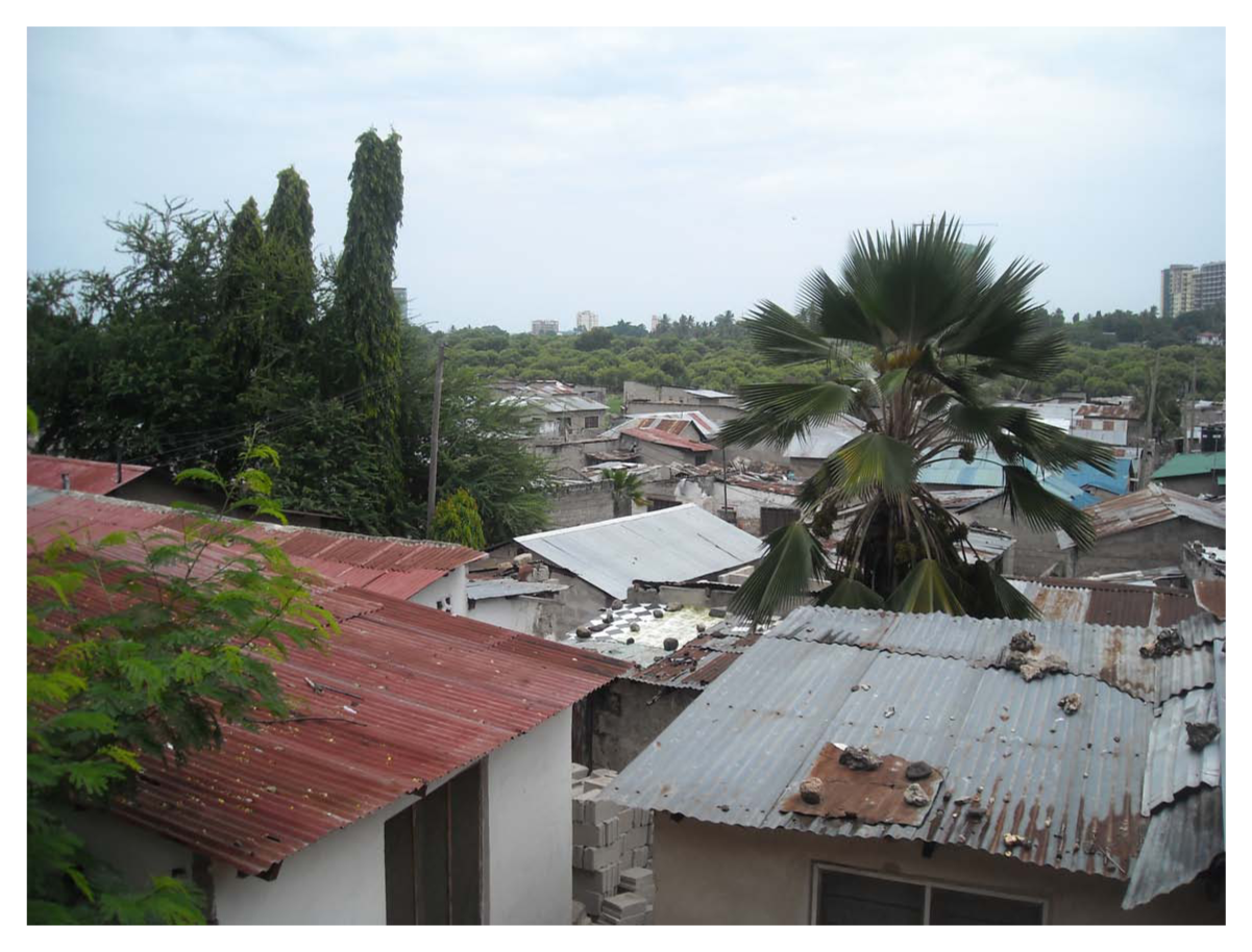
High-density unplanned settlement at Hananasifu
Medium-density unplanned settlements, including Mlalakuwa, Makongo, Mbezi and Kimara, are located at medium distance from the city centre and have land lots that are not fully built (Photo 2). The low-density unplanned settlements are a long way from the city centre, and include Goba, Bunju, Chamazi, Chanika and Somangila. They have large land lots that are sparsely built and populated.
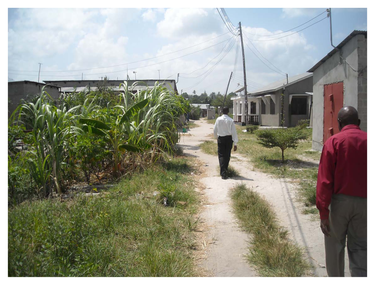
Medium-density unplanned settlement at Kipawa
The housing in planned areas is of acceptable standard and is mostly built of cement blocks and iron sheets or tiles and conforms to city building codes. In unplanned areas, many houses do not conform to these codes and are built of poor quality materials with no area set aside for the provision of public services. However, there are exceptions, as not all housing in unplanned areas is of poor quality.
The government of Tanzania and the Dar es Salaam city authorities have put in place a number of development strategies to improve the social, economic and environmental conditions of the city residents. These strategies include upgrading squatter areas rather demolishing them, and improving transport networks (especially roads), water supply, sanitation, public transport, and education and public health systems. But these efforts have not achieved what was anticipated because of a number of key challenges. Foremost among these is that the city lacks adequate resources for planning and providing the basic services needed in the rapidly expanding city. In addition, the city has no overall development plan – the last master plan dates back to 1979. The lack of a master plan and associated development control has contributed to the haphazard development. This is reflected in the number of residents and businesses in unplanned areas, including river valleys, and also in the inadequate basic services and high traffic congestion.
The need for attention to land use management has long been recognized – but not acted on. The 1979 Dar es Salaam Master Plan identified the need to prevent or restrict residential developments in areas at risk from floods and erosion; but commercial and residential developments were subsequently approved in such areas.(18)
III. Climate Change Hazards, Exposure and Vulnerabilities
Data from the Tanzania Meteorological Agency (TMA) show that temperatures in Tanzania have been rising since the 1960s in a trend similar to that of the global average.(19) Tanzania is predicted to become warmer by 2.5° to 4.5°C by the year 2080 under the A2 scenario.(20) Precipitation is projected to increase in all rainfall seasons, with coastal and southern parts experiencing the greatest increases.(21) Dar es Salaam has already become warmer – data from the TMA indicate an increase in both minimum and maximum temperatures over the last four to five decades.(22) The data also show a decrease in the number of rainfall days and mean annual rainfall, and increased variability in rainfall intensity. It should be noted that the mean annual rainfall reduction in the city for the last four decades contradicts projections of an increase in rainfall along the coastal areas of Tanzania.
Climate change will lead to increased occurrences of extreme weather events in Tanzania, including rainstorms, droughts and sea level rise. An analysis of the exposure of population and assets to coastal flooding showed that eight per cent of Dar es Salaam lies in the Low Elevation Coastal Zone, which lies below 10 metres above mean sea level.(23) About 140,000 people, with economic assets worth more than US$ 168 million, are in this zone. Even without considering sea level rise, more than 31,000 people are currently at risk from the 1-in-100 year storm surge (i.e. a 3.09 metre rise in water level). The population exposed to risk of sea level rise is anticipated to increase to 100,000 and the value of assets to more than US$ 400 million by 2030.(24) Already, some locations in Dar es Salaam, including Kunduchi/Bahari and Ocean Road beach areas, are being eroded due to sea level rise and/or storm surges. Rainstorms and sea level rise are likely to lead to increases in frequency and severity of flooding.
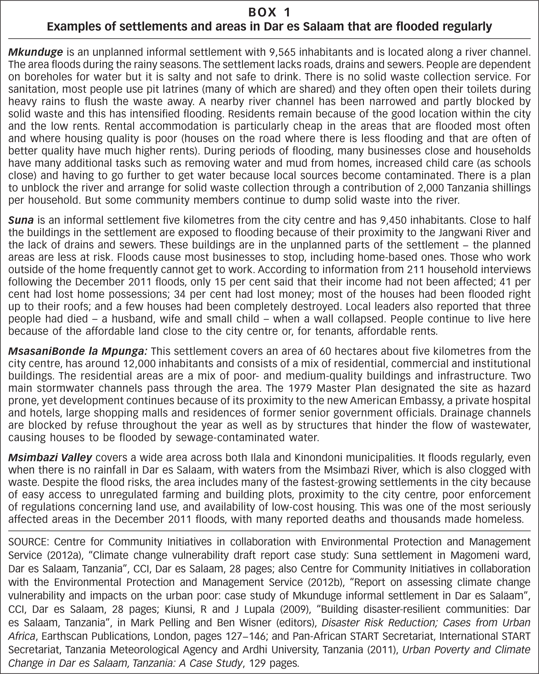
Figure 1 shows the population exposed to flooding in different years under the A1B scenario with no adaptation.(25) Those mos at risk are the communities living in the unplanned settlements in river valleys and along the Indian Ocean shores. Studies conducted by the Pan-African START Secretariat(26) in unplanned lowland settlements (Msasani Bonde la Mpunga, Msimbazi Valley, Jangwani and Mkocheni B Vigunguti, Mtambani and Mnyamani, and Kizinga River) showed that the top five environmental risks as perceived by the local communities were flooding, temperature rise, drought, increases in disease, and air pollution. Flooding is exacerbated by poor planning, the poor drainage system and housing conditions, and lack of capacity of the local communities to adapt to flooding.(27) Figure 2 shows the flood-prone areas overlaid on unplanned settlements in the city, and Box 1 gives examples of settlements and areas in Dar es Salaam that are flooded regularly.
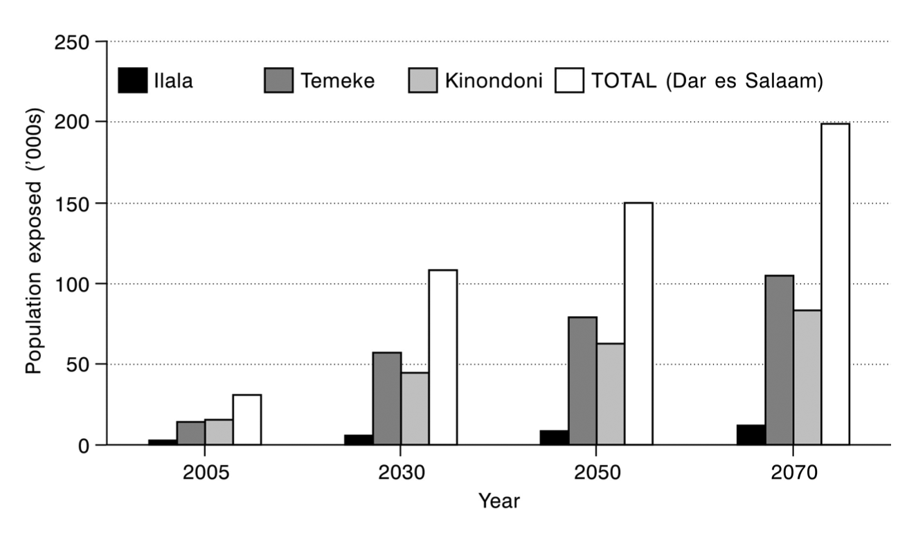
Population exposed to 1-in-100 year flood event in 2005, 2030, 2050 and 2070 under the A1B mid-range SLR scenario, no adaptation
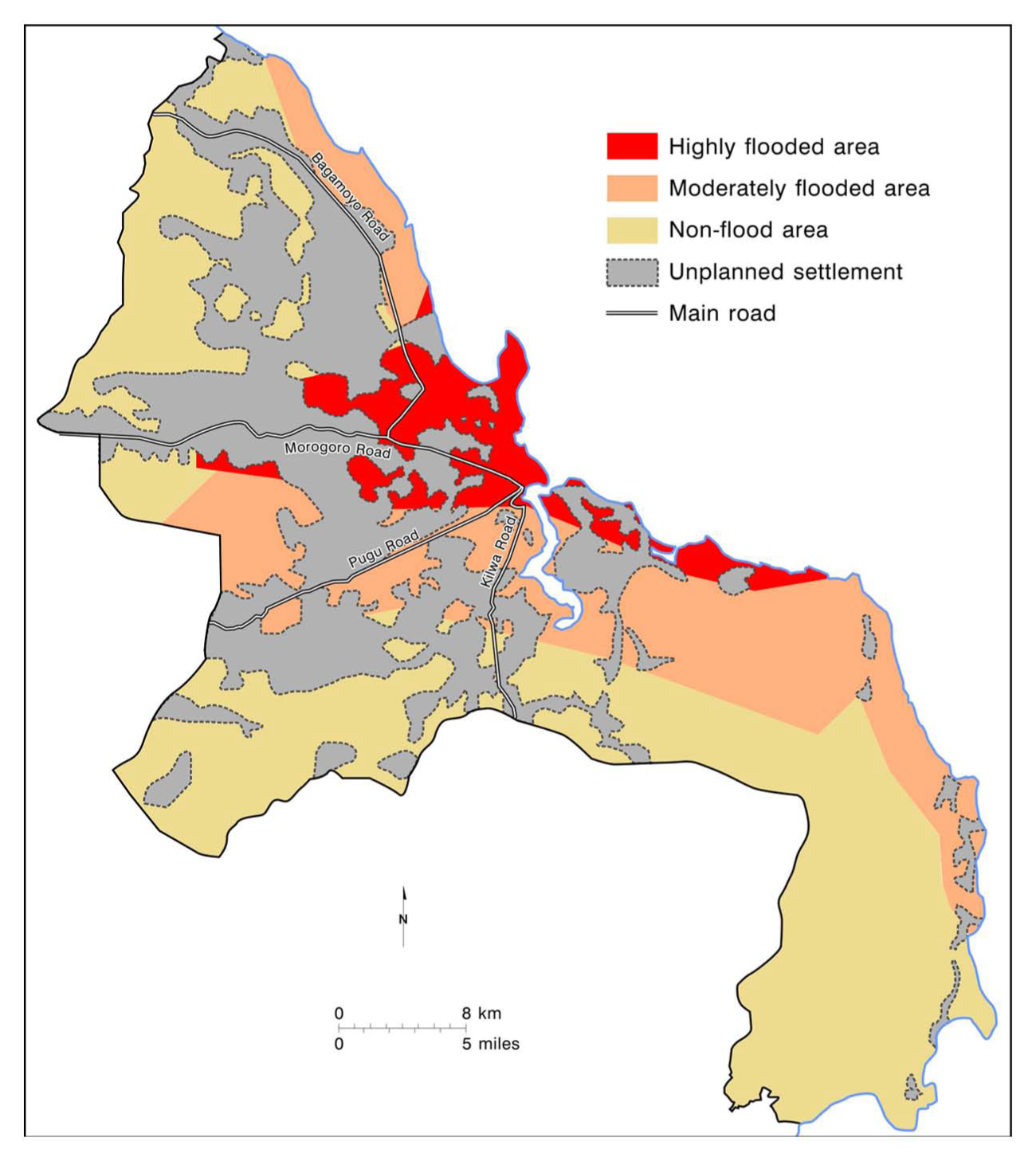
Flood hazard map overlain on urban unplanned settlements
Drought is a major problem in many regions of the country.(28) In cities, droughts contribute directly to water and electricity shortages and to increases in food prices. Dar es Salaam, for instance, is directly affected by drought as it depends on hydropower for its electricity, surface (river) water for its main water supply and on food from rural areas.
IV. Development of Adaptation Initiatives
There are two main kinds of adaptation initiatives in Dar es Salaam: those that are aimed primarily at addressing development deficit, which in the course of their implementation indirectly contribute to climate change adaptation; and those that are directly related to climate change adaptation.
a. Programmes to address the development deficit
To reduce the development deficit in Dar es Salaam, the government of Tanzania and the city authorities have introduced and implemented a number of programmes; the main ones, according to the UN–Habitat Citywide Action Plan,(29) are the Community Infrastructure Upgrading Programme (CIUP), the Programme to Formalize Unplanned Areas through Residential Licences, the 20,000 Plots Project, the Water and Sanitation Improvement Programme and the Citywide Action Plan for Upgrading Unplanned Settlements in Dar es Salaam. These programmes focus mostly on improving public services and infrastructure, formalizing existing unplanned settlements and controlling the rapid growth of informal settlements. Table 1 summarizes the main objectives, activities, budget and outputs for each programme or project.
Measures taken to address Dar es Salaam’s development deficits
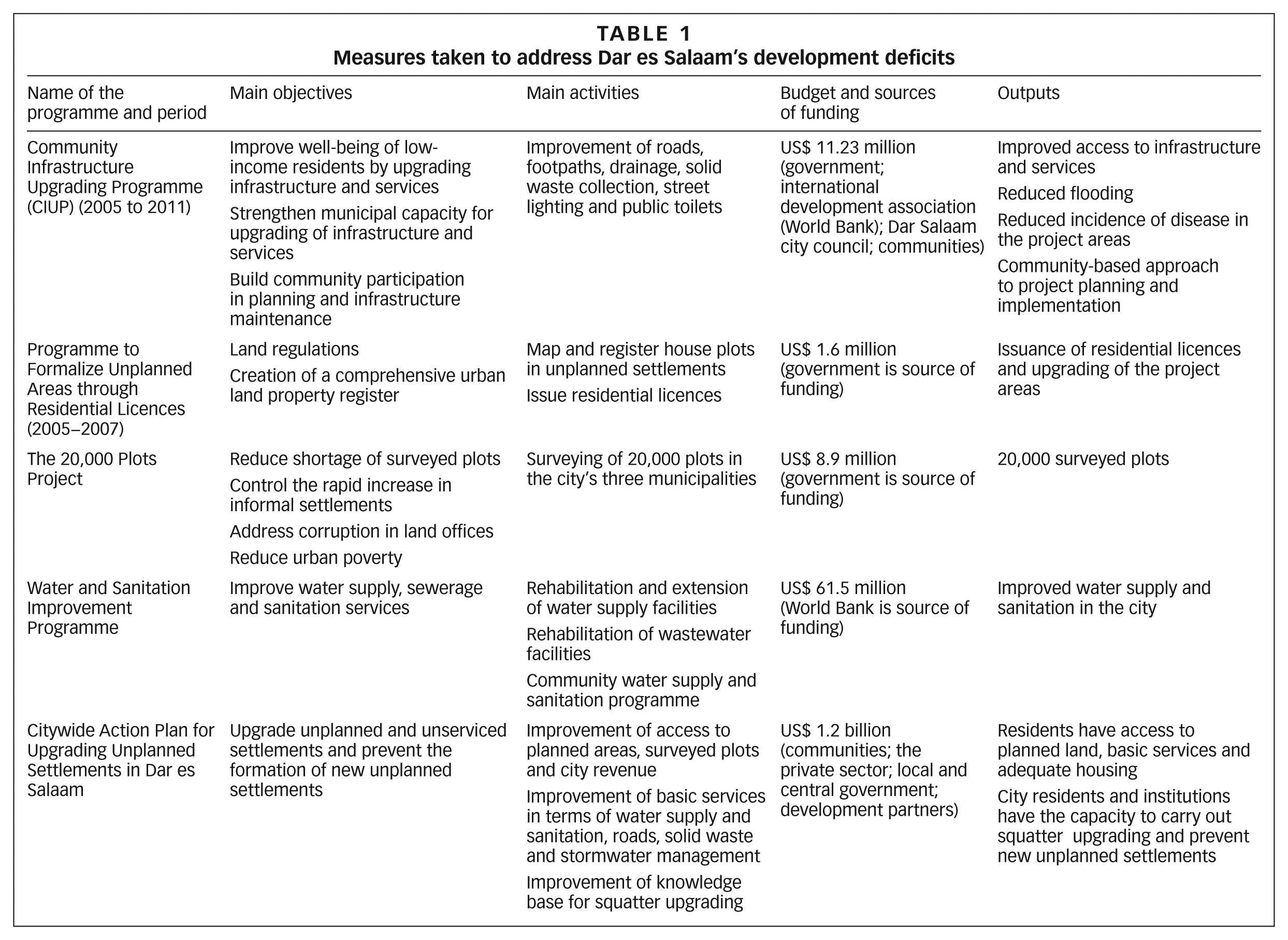
Dar es Salaam is currently implementing a Citywide Action Plan for Upgrading Unplanned Settlements for a 10-year period from 2010 to 2020. The main goal is to upgrade half of the existing unplanned and unserviced settlements and to prevent the formation of new unplanned settlements. This comprises three main themes, namely land, basic services and housing, and each has its own action plan. The land action plan seeks to improve access to planned areas, increase city revenue from land taxation, increase provision of surveyed plots and control densification of residential areas. The basic services action plan seeks to improve access to basic services, including drinking water and sanitation, and increase coverage of roads, stormwater drains and improved solid waste management. The housing action plan aims to increase access to housing. There is also a capacity-building action plan that seeks to improve the knowledge base and skills required to upgrade unplanned settlements and prevent the development of new squatter areas.
The implementation of the programme is spearheaded by the Citywide Slum Upgrading and Prevention Programme Unit (CSUPPU) assisted by the Steering Committee, which draws its members from city government, Dar es Salaam municipal governments, sector ministries, the Prime Minister’s Office, academic and research institutions and development partners. A technical committee assists both the CSUPPU and the Steering Committee. The local communities participate in the programme through the community planning committees. The programme is costing US$ 1.2 billion and is being implemented with UN–Habitat and Cities Alliance technical assistance. The funds for the programme will be raised from various sources, including contributions from local communities, the private sector, municipal councils, central government and development partners.
b. Climate change adaptation
As noted already, there is little knowledge or capacity with regard to developing climate change adaptation for Dar es Salaam, and little evidence of any planning and implementation of climate change adaptation measures either there or in other urban areas. Available documentation and discussions with key city officials indicate no clear separation of adaptation and mitigation options. The most commonly mentioned measures to address climate change in the city can be divided into three main categories. The first is the development programmes, already discussed, which are primarily meant to address development deficit. The second category relates to measures that focus on mitigation and the main activities here include: tree planting; the protection of coral reefs and mangrove vegetation; using more efficient cooking stoves; promoting the use of natural gas instead of oil and coal or using briquettes (to cut down on fuelwood/charcoal use); using energy-saving street lights; an improved public transport system; and methane gas capture at waste disposal sites. In Dar es Salaam, a number of industries have already switched to natural gas. The third category is direct adaptation measures, and these include rainwater harvesting and building sea walls and groynes.
Climate change solutions in the city are formulated and implemented at three main levels: city, municipal and household. At the city level, Dar es Salaam has developed a number of international alliances with regard to climate change. These include membership of the Mayors’ Task Force on Climate Change, Disaster Risk and Urban Poor; ICLEI Local Governments for Sustainable Development; and the World Bank. A study on urban poverty and climate change in Dar es Salaam was conducted under the auspices of the Mayors’ Task Force(30) and gives an overview of climate change impacts and adaptation measures in the city. In Temeke municipality, a capacity-building programme on climate change adaptation was implemented under ICLEI, and this included workshops for municipality staff and other selected key stakeholders as well as planting mangrove trees in a degraded mangrove forest area. The main objectives of the workshops were to raise awareness of climate change, the impacts and adaptation measures. As in São Paulo and Jakarta, Dar es Salaam has a Carbon Finance Capacity-Building Programme (CFCBP), and this includes training through distance and direct learning on how to develop carbon projects in the city. The city is also implementing a climate change mitigation project at the now-closed Mtoni solid waste dump site, where methane gas is captured and intended for use to generate 2.5 to 5 MW of electricity. In terms of infrastructure development, the city has constructed a sea wall near the Ocean Road hospital to protect the road from being washed over by sea waves.
At an individual level, hotel owners on the northern beaches of Dar es Salaam where coastal erosion is a serious problem have built groynes to protect their hotels and beaches (Photo 3).
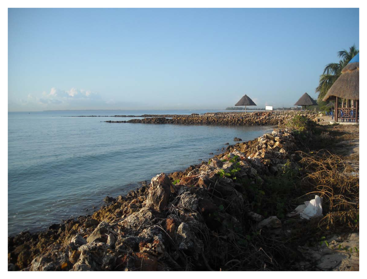
Groynes protecting one of the beach hotels in Dar es Salaam
A good example of adaptation action at the community level in Dar es Salaam is provided by Msasani Bonde la Mpunga residents, who formed a flooding committee that worked with the city authorities and the Prime Minister’s Office. Bonde la Mpunga is one of the many informal settlements located in low-lying areas prone to flooding. Initially, it was made up mostly of unplanned residential houses that are now being replaced by commercial buildings, as the area is near the city centre. This community action led to the construction of stormwater drainage that reduced flooding problems in the area.(31)
Households also take measures to protect their properties, especially those living in flood-prone areas. In Mtoni, an unplanned area where a natural drainage system is partially blocked by residential houses, some households have built low walls in front of their homes to prevent stormwater entering (Photo 4). In Kijiji Cha Wavuvi settlement, which is located within the Mtoni unplanned area on the shores of the Indian Ocean, there is a large natural drainage channel that runs from an industrial compound and that directs stormwater to the sea. To protect their houses from being washed away by stormwater and high sea tides, residents have stacked used tyres along the drainage channel (Photo 5). Other coping mechanisms to help protect against flooding include putting possessions on high shelves or on roofs, hanging furniture and other possessions from hooks high up on walls and sleeping on tables or roofs.
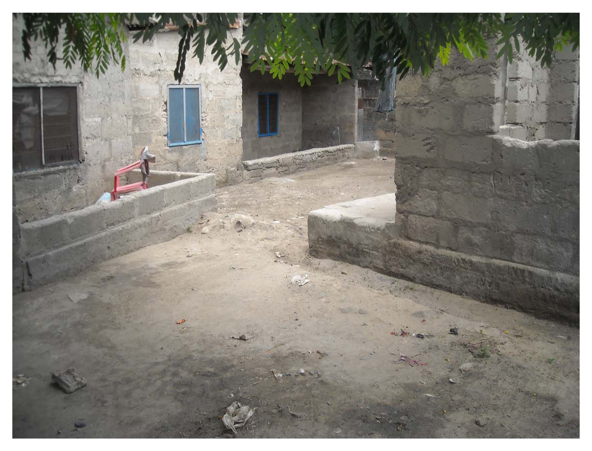
Low-built walls in Mtoni unplanned settlement to protect against stormwater
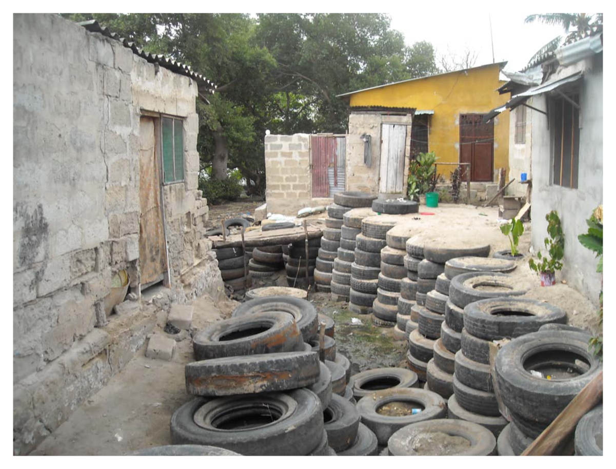
Stacked-up used tyres to protect houses against rain and sea stormwater
V. Synergies With Disaster Risk Response: Adaptation–Mitigation–Development
Disaster risk response in Tanzania is coordinated by the Disaster Management Department located in the Prime Minister’s Office. As per policy requirements, disaster management committees have been set up at national, regional, district, ward and village levels. However, the policy does not provide for setting up disaster management committees in urban areas.
Climate change issues come under the Division of Environment in the Vice President’s Office, and at the city level under the Standing Committee on Urban Planning and Environment. Climate change issues at an urban level are not fully articulated compared, for example, to environmental assessments and attention to solid waste and pollution. In Dar es Salaam, the synergies between disaster risk response and adaptation and mitigation are not being articulated, primarily due to institutional arrangements that do not provide direct links between disaster management and climate change adaptation. There has been little coordination between disaster risk reduction and climate change adaptation among the key institutions.
The December 2011 floods that hit Dar es Salaam clearly showed the need for links between climate change and disaster risk response, but also the importance of links between disaster risk reduction and physical planning and infrastructure development. The International Federation of Red Cross and Red Crescent Societies reported that the 2011 floods caused 20 deaths, injured more than 200 persons and displaced 10,000 people.(32) City officials reported that Dar es Salaam is now preparing a disaster resilient action plan, which will include a disaster recovery centre that ideally will address some of the temporary resettlement challenges that occurred after the December 2011 floods.(33) The recovery centre will ensure the availability of accommodation and other essential facilities needed during a disaster rescue phase. The 2011 floods also highlighted the need for the disaster management policy, which is under review, to include climate change impacts and mitigation and adaptation issues.
VI. Stakeholder Engagement
Stakeholder engagement in the city includes both those in development deficit programmes and those involved in climate adaptation or mitigation activities. The main stakeholders in programmes to address the development deficit are the government of Tanzania, international development agencies, the city council and local communities; the latter’s participation is strong in development programmes. International development agencies provide technical assistance and the bulk of funds, while the government provides partial funding. The city council contributes a small percentage of necessary funds but has overall responsibility for running these programmes.
In direct adaptation or mitigation projects that are formulated by the city authorities, the key players are the Division of Environment in the Vice President’s Office, the city council and the international development agencies. The Division of Environment negotiates with the international agencies for funding and technical aspects and the city implements the project. There is very little community participation and the main project ideas come from the international agencies and the Division of Environment.
Research activities within higher-learning institutions on climate change and its impacts are on the increase. Three research programmes are highlighted here. The first is Climate Change Impacts, Adaptation and Mitigation in Tanzania (CCIAM) funded by the government of Norway. This is a collaborative programme involving Sokoine University of Agriculture, the University of Dar es Salaam, Ardhi University, the Tanzania Meteorological Agency (TMA) and a number of universities in Norway, including the University of Life Sciences. Its main focus is in rural areas, especially in the Reducing Emissions from Deforestation and Forest Degradation (REDD) programme.
The second research programme is Climate Change and Urban Vulnerability in Africa (CLUVA), which involves five universities from Africa and a number of European and African research institutions.(34) The research activities focus on Addis Ababa, Dar es Salaam, Douala, Ouagadougou and Saint Louis. Each city has a specific research focus: Dar es Salaam on sea level rise, coastal erosion and flooding; Addis Ababa on drought, desertification and water scarcity; Douala on sea level rise and flooding; Ouagadougou on drought and flooding from intense rainfall; and Saint Louis on sea level rise and flooding. The programme is funded by the European Union with the main goal of developing methods and knowledge to be applied to African cities in order to manage climate change risks, reduce vulnerabilities and improve coping capacity and resilience. In Dar es Salaam, five research projects at a PhD level are being conducted under this programme, namely climate change modelling, impacts of climate change on urban infrastructure, urban heat islands, vulnerability assessments of flood-prone areas, and land use development control. Results from the research projects will be available in 2013.
The third research programme is Adapting to Climate Change in Coastal Dar es Salaam (ACC DAR). This is partly funded by the European Union and is being implemented by the Inter-university Research Centre on Sustainable Development at Sapienza University in Rome in collaboration with Ardhi University in Tanzania. It aims to contribute to the implementation of the National Adaptation Programme of Action (NAPA). Initial findings indicate that most urban dwellers perceive changes in the environment to be the result of a combination of factors, including climate variability, and poor development control and environmental management.(35) Knowledge about and understanding of climate change issues is low and this helps explain their lack of inclusion in the city’s development activities. This paper recommends that in order for climate change issues to be taken into account, the knowledge and technical skills of city employees need to be improved.
VII. Mandate for Action
Environmental and climate change issues are guided by the National Environmental Policy and the Environmental Management Act. The 1979 National Environmental Policy provides the overall framework for the management of environmental issues in Tanzania, but does not list climate change as one of the problems facing the country. The Environmental Management Act (EMA) 2004 forms the legislation governing the management of environmental concerns in the country. Section 75 of the Act points out measures that could be taken to address climate change issues, which include adaptation measures, the issuance of guidelines for handling climate change issues and putting in place strategies for their management. This is supported by a number of sectoral laws, some of which have environmental components. However, many of the sectoral policies and acts do not address climate change issues directly. The Division of the Environment, housed within the Vice President’s Office, is the main coordinator for climate change issues in the country. It issued a draft National Climate Change Strategy and Action Plan in 2012,(36) which highlights adaptation actions to be taken by different sectors, including for human settlements. In the human settlements sector, the proposed strategic interventions are the improvement of building standards and land use, the relocation of communities living in flood-prone areas and the promotion of sustainable housing schemes. The National Climate Change Committee is composed of senior government officials from different sectors and research institutions, and it provides overall guidance on the management of climate change issues in the country. Its main function is to advise the Division of Environment on such issues and also on mitigation and adaptation measures. It works together with sector ministries, research institutions and NGOs but there is no clearly formalized institutional arrangement for climate change management in urban areas.
VIII. Conclusions
Planning and implementing climate change adaptation in Dar es Salaam still receives very low priority and, to date, there have been no significant city level climate change adaptation activities. Households, communities and businesses impacted by floods or beach loss have taken some measures, which include the widespread practice of constructing groynes to protect hotels in areas prone to coastal erosion, and raising foundations and building low walls in front of houses as a protection against stormwater. The implementation of development deficit programmes has a number of outcomes, including overall improvement in living conditions in upgraded planned areas. Improvements include better road accessibility, stormwater drainage and solid waste management. Upgrading programmes have reduced the occurrence of floods in some unplanned areas, including in Vingunguti settlement, which was well known for its flooding problems before being upgraded.
Dar es Salaam faces a large development deficit as well as current climate change impacts and future impacts that need to be planned for. To date, the government’s priority has been to improve the social and economic conditions and infrastructure. The capacity of the city to manage development so that it also addresses climate change issues is low and needs to be improved. Action is needed in four main areas:
Raising the awareness of both the general public and the decision makers regarding climate change issues and how these can be incorporated into development activities.
Improving the knowledge base of city employees, especially the physical planners and engineers. This will enable them to take account of climate change issues when preparing city plans and projects.
Increasing the financial capacity of the city through improved tax collection or external support.
Mainstreaming climate change adaptation into the development plans for upgrading the unplanned areas.
Footnotes
1.
2.
UN–Habitat (2008), The State of African Cities 2008: A Framework for Addressing Urban Challenges in Africa, UN–Habitat, Nairobi, 206 pages; also Pan-African START Secretariat, International START Secretariat, Tanzania Meteorological Agency and Ardhi University, Tanzania (2011), Urban Poverty and Climate Change in Dar es Salaam, Tanzania: A Case Study, 129 pages.
3.
4.
5.
Nnkya, T and J Lupala (2010), “Planning education in Tanzania: the experience of Ardhi University”, The Journal of Building and Land Development, Special Issue, pages 157–173; also see reference 2, ![]() .
.
6.
Lupala, J and R Kiunsi (2011), “Dar es Salaam city, 50 years to come: conceptual considerations”, unpublished workshop Working Paper presented during the 50 Years Anniversary of the University of Dar es Salaam, Tanzania.
8.
See reference 7.
10.
See reference 7.
11.
12.
See reference 7.
13.
See reference 11.
14.
Mittal, S C (1976), “Space standards for residential development for urban areas of the United Republic of Tanzania”, Paper presented at Ardhi Annual Conference, Moshi, Tanzania, December 1976; also ![]() , The Town and Country Planning (Town Planning Space Standards) Regulations, Government Notice No 157, Dar es Salaam, 10 pages.
, The Town and Country Planning (Town Planning Space Standards) Regulations, Government Notice No 157, Dar es Salaam, 10 pages.
15.
Kiunsi, R (2013), “A review of traffic congestion in Dar es Salaam city from the physical planning perspective”, Journal of Sustainable Development Vol 6, No 2, pages 94–103.
16.
See reference 11; also Kiunsi, R and J Lupala (2009), “Building disaster-resilient communities: Dar es Salaam, Tanzania”, in Mark Pelling and Ben Wisner (editors), Disaster Risk Reduction; Cases from Urban Africa, Earthscan Publications, London, pages 127–146.
17.
See reference 4.
18.
Meshack, M, F Lerise, J Lupala and R Kiunsi (2006), “Community initiatives in managing urbanization and risk accumulation processes: lessons from Dar es Salaam, Tanzania”, University College of Lands and Architectural Studies, Dar es Salaam, 129 pages.
19.
IPCC (2007), Climate Change 2007: Synthesis Report, Cambridge University Press, 52 pages; also Mtongori, I and P M Innes (2010), “Climate change impacts in East Africa”, Paper submitted to the Second International Conference on Climate, Sustainability and Development in Semi-arid Regions, Fortaleza–Ceara, Brazil, August 16–20; and Mongi, H, A E Majule and J G Lyimo (2010), “Vulnerability and adaptation of rain-fed agriculture to climate change and variability in semi-arid Tanzania”, African Journal of Environmental Science and Technology Vol 4, No 6, pages 371–381.
20.
23.
Kebede, A S and R J Nicholls (2011), “Population and assets exposure to coastal flooding in Dar es Salaam (Tanzania): vulnerability to climate extremes”, Report submitted to the Global Climate Adaptation Partnership (GCAP), University of Southampton, School of Civil Engineering and Tyndall Centre for Climate Change Research, UK, 26 pages.
24.
See reference 23.
25.
See reference 20.
27.
Watkiss, P, T Downing, J Dyszynski, S Pye et al. (2011), “The economics of climate change in the United Republic of Tanzania”, Report for Development Partners Group and the UK Department for International Development, January, available at ![]() , 34 pages.
, 34 pages.
28.
World Food Programme (2010), Comprehensive Food Security and Vulnerability Analysis (CFSVA), United Republic of Tanzania, WFP, Rome, 228 pages; also see reference 19, ![]() .
.
29.
See reference 4.
30.
World Bank (2011), “Climate change, disaster risk and the urban poor: cities building resilience for a changing world (Summary)”, World Bank, Washington DC, 33 pages; also see reference 2, ![]() .
.
31.
Kiunsi, R, G Kassenga, J Lupala, B Malele, G Uhinga and D Rugai (2009), “Mainstreaming disaster risk reduction in urban planning practice in Tanzania”, Research Report submitted to AURAN, 44 pages.
33.
Such a centre would also have served in response to other disasters such as the bomb blasts in army barracks in 2009 and 2011, which caused many deaths and damage to property and displaced thousands of people.
35.
Kassenga, G and S Mbuligwe (2012), “Report on an investigation of Dar es Salaam’s institutional activities related to climate change”, unpublished ACC DAR Working Paper, 95 pages.