
Abstract
Climate change presents cities with significant challenges such as adaptation to dynamic climate risks and protection of critical infrastructure systems and residents’ livelihoods. City governments and inhabitants must continually respond to a variety of urban environmental risks. Understanding how cities have begun to extend these experiences to the context of climate change adaptation as well as mitigation is crucial for the development and identification of climate action best practices. The focus of this paper will be to document and explore how the city of New York has begun to define and implement a set of climate actions over the past half decade. These actions are presented within a discussion of past and future climate risks and vulnerabilities, and of climate and sustainability programmes that the city government has developed recently. Even as a mature, mega-city in a developed country, lessons from the New York City experience can be transferred to a variety of other urban contexts.
I. Introduction
New York City has responded to a variety of significant environmental challenges in its history, and the latest one, which requires long-term strategic planning, is climate change. Climate change is projected to have wide impacts on the city’s critical infrastructure and population through higher temperatures, more intense flooding events and sea level rise.(1) Because it recognized early the risks posed by climate change, and because of its current commitment to mitigation of greenhouse gas (GHG) emissions as well as to adaptation, New York City has become a US national and international leader in responding to climate change.(2) The city’s actions to date provide an illustration of how a large city can respond to this new urban environmental challenge through climate adaptation planning and, in turn, connect to the ongoing process of urbanization. The objective here will be to review how this process has unfolded in New York City’s past and current socio-environmental context.
II. Location and Key Characteristics
New York City is one of the most populous cities in the world. As of 2010 it had an official population of 8,175,133,(3) and the extended metropolitan region beyond the city’s municipal borders has approximately another 14,000,000 residents. The city and metropolitan region are located in the Atlantic Ocean coastal zone of the eastern United States and have a temperate continental climate. Four of the five city boroughs (the US counties that compose the city) are islands, or on islands, and have extensive coastlines. The rest of the New York metropolitan region includes a further 28 US counties.
By the early 1800s, New York City – founded as a Dutch colonial outpost in the early 1600s – had become the largest city in the United States and remains so today. Since its beginnings, New York has been continually recast – from a minor frontier settlement to a port city, a manufacturing city, a financial centre and eventually, a de facto world capital (along with other global cities such as London and Tokyo). While each shift (i.e. transformation) has been associated with tension (i.e. crises) and change (i.e. transition), probably the most profound moment came with its shift from a relatively compact mid-nineteenth century city clustered around its port to the sprawling turn of the twentieth century city spreading out into places that were long considered its hinterlands.(4)
Throughout the period from 1800 to the present, New York City has experienced several environmental crises and transitions.(5) In general, these have mirrored the growth of the city as a modern metropolis, and most involved a series of lead-up events, early attempts at solutions, heightened levels of concern and eventual resolution. These solutions, however, also precipitated unintended consequences, which in themselves resulted in environmental change and degradation and will result in other future crises (Table 1). Climate change impacts pose another looming challenge for city managers and residents to resolve because of the potential large costs and disruption they could cause.
Environmental crises in New York City
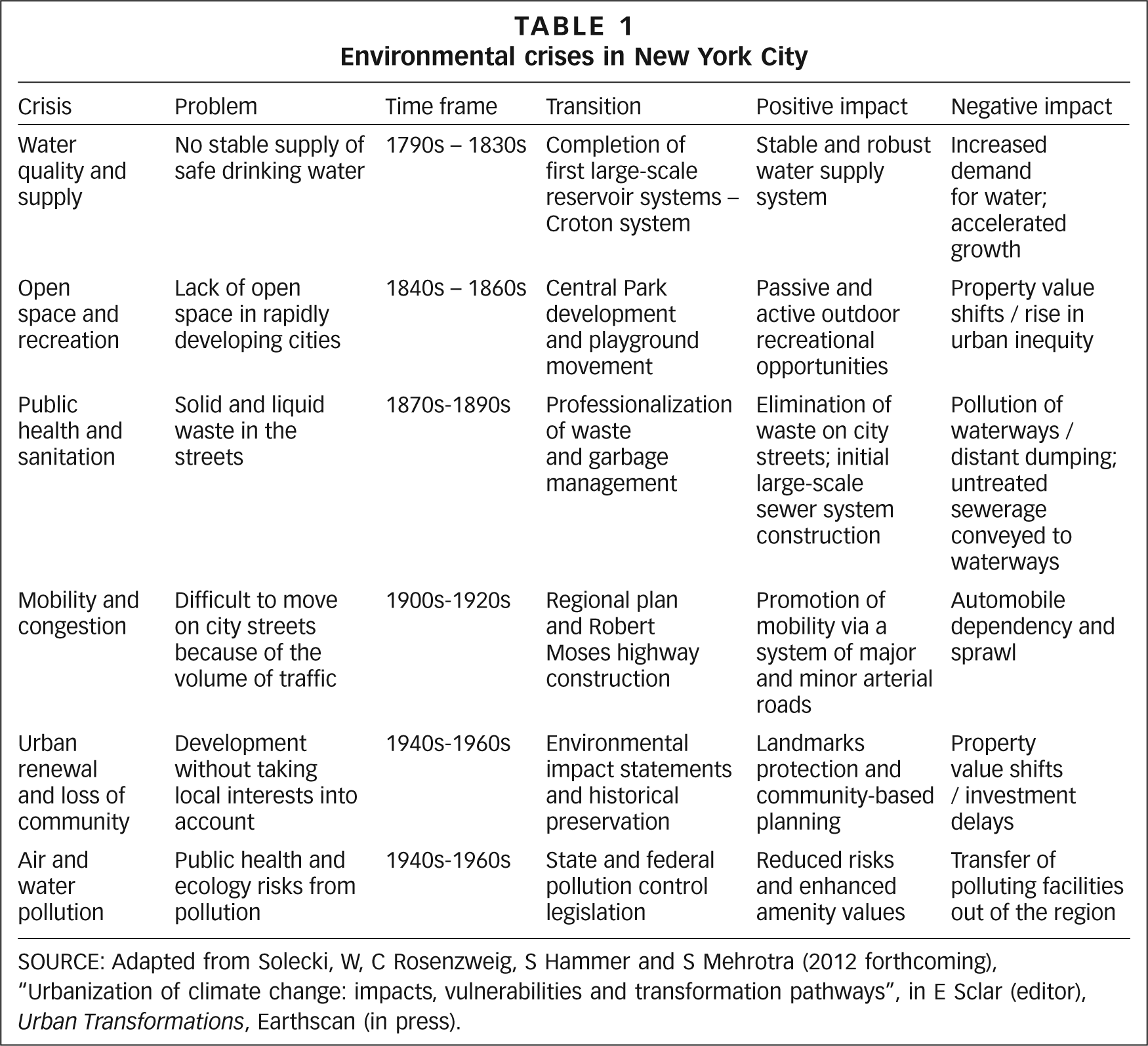
SOURCE: Adapted from Solecki, W, C Rosenzweig, S Hammer and S Mehrotra (2012 forthcoming), “Urbanization of climate change: impacts, vulnerabilities and transformation pathways”, in E Sclar (editor), Urban Transformations, Earthscan (in press).
III. Development Profile and Deficits
New York City has some of the densest and most complex infrastructure in the world, much of which is ageing rapidly.(6) Elements of the infrastructure and materials may not be able to withstand the projected strains and stresses from a changing climate. The city’s infrastructure can be considered within four main systems: energy, transportation, water and waste, and communications. Much of the large-scale infrastructure is near or on the coast or estuarine environments and was built during the early and mid-twentieth century, when most of the available sites were at the water’s edge either on or near remnant wetlands or derelict industrial sites. An obvious example of this phenomenon is the city’s three major international airports – each built on low elevation or landfill sites that are vulnerable to flooding.
The city’s infrastructure profile includes some of the following characteristics:
1.1 billion gallons of water supplied each day from a 5,108 square mile watershed;
145,000 kilometres of underground electrical distribution lines across 55 distribution networks;
6,600 miles of sewer piping, almost 100 sewerage pumping stations and 14 water pollution control plants;
6,000 miles of water distribution piping within the city’s borders;
approximately one million buildings within the five boroughs (i.e. counties) that make up New York City;
multiple large-scale rail transit systems that involve just under 3,400 kilometres of track in the metropolitan area, including 1,352 kilometres of subway that alone transport 1.5 billion passengers annually;
recycling or disposal of 15,500 tonnes per day of rubbish and other waste;
three international airports as well as three smaller regional airports across the metropolitan region;
two dozen major electricity-generating facilities; and
a vast network of fixed and mobile telecommunication networks for personal, public (e.g. emergency) and business (e.g. Wall Street banking and investment companies) use.
New York City’s infrastructure systems are tightly coupled, leading to the possibility of a cascade of failures and secondary and tertiary climate impacts. For example, an intense rainstorm and associated flash flooding on 8 August 2007 rendered almost the entire subway system inoperable, causing significant economic losses that day because employees and customers could not get into the city’s central business districts.(7) This complex set of infrastructure systems is located across a sprawling metropolitan region that includes territory of three US states (Connecticut, New Jersey and New York) and several thousand, often overlapping, jurisdictions, including municipal, county, state, federal and other agency/authority boundaries.
The region is composed of high density urban core areas with densities exceeding 100,000 people per square kilometre. The extended metropolitan region includes older higher density suburbs that surround the urban core areas, lower density mostly automobile-dependent suburbs, and more distant ex-urban, remnant agricultural areas. Ongoing urbanization occurs largely as a result of foundational public policies that include land use zoning, development of large-scale infrastructure, critical resource management (e.g. protection of drinking water supply) and market level land pricing. While the quality of the residential housing stock varies widely across the city and the region, almost all the housing is of moderate to high quality by international standards and maintains indoor plumbing, electricity and basic protection from the elements.
IV. Existing and Future Climate Challenges
Current key climate risks include coastal flooding and storm surge, inland (street) flooding, heat waves and extreme wind events, as well as more urban-related risks such as urban heat islands and primary and secondary air pollutants. Climate change is expected to exacerbate these risks.(8) Given its population density and intense built environment, the region is seen as vulnerable to extreme storm events such as hurricanes, which could cause in excess of several hundred billion US$ in damage.(9) Although no single weather-related event can be attributed to climate change, New York City has experienced climate extremes in its recent history that have highlighted the potential risks to the city’s critical infrastructure posed by climate change. These extreme climate-related events include Hurricane Irene in August 2011, which caused the city government for the first time to implement its storm surge evacuation plan and associated risk reduction planning activities on a broad scale (e.g. shutting down the public transit system and authorizing a mandatory evacuation of the areas to be inundated under a Category 1 hurricane storm surge). Although the storm surge flooding was not as great as expected, the city agencies were able to test their emergency planning protocols.(10)
Other recent weather extremes include the summers of 2010 and 2011, which were exceedingly hot and stormy. The summer of 2011 was particularly intense – July was one of the hottest months on record for New York City, while August was one of the wettest.(11) These events and others provide valuable insights into the impacts that climate change could have in the future. They also highlight the need, even without climate change, to improve the city’s resilience to environmental stressors, of which climate extremes are one of the most important. In many cases, linking adaptation efforts to the climate risks faced by the city today is presented as an effective climate action strategy.
Besides the August 2007 downpour and the 2011 Hurricane Irene, the city has experienced other major climate events that have become important benchmarks with respect to the relative level of impact and disruption. These are briefly noted below:
1999: Hurricane/tropical storm Floyd – widespread flooding following massive rainfall, in many cases greater than 30 centimetres;
1992: December Nor’easter – extensive flooding of regional transportation systems;
1985: Hurricane Gloria – storm surge causes extensive coastal damage and flooding;
1960s: mid-decade drought of record; illustrates massive capacity of city’s water supply system;
1947: Nor-easter – extensive flooding of regional transportation systems; results in building of flood mitigation features for a city airport;
1938: Long Island Express hurricane – most powerful storm to impact metropolitan region; extensive damage to what were still relatively rural parts of Long Island (now heavily suburbanized); and
1888: March blizzard cripples and disrupts new electricity and telephone wiring; promotes the location of critical wiring underground.
New York’s coastal location, with almost 1,500 kilometres of shoreline (including tidal wetlands), means that future climate change and associated sea level rise and increased probability of storm surge-associated coastal flooding are widely seen as the most significant challenges to the city.(12) The sea level rise projections derived from the IPCC-based methods from AR4 show, using the central range or middle 67 per cent of the model distribution, the mean annual sea level rise in New York City as being 5.1–12.7 centimetres by the 2020s; 17.8–30.5 centimetres by the 2050s; and 30.5–58.4 centimetres by the 2080s.(13) In response to discussions within the scientific community that the IPCC (2007) approach to sea level rise may underestimate the range of possible increases, in large part because it does not fully consider the potential for land-based ice sheets to melt due to dynamical processes,(14) an alternative method that incorporates observed and longer-term historical ice melt rates was also developed. The “rapid ice melt” approach suggests sea level could rise by approximately 0.9–1.5 metres (with a central range of 1.0–1.4 metres) by the 2080s. The range in the “rapid ice melt” scenario represents a combination of global climate model results and paleoclimatic uncertainties related to timing of deglaciation.
These projections provide information on how the frequency of future flooding events might shift. Sea level risk will result in even more frequent future flood occurrences relative to the current 1-in-10 and 1-in-100 year coastal flood events. By the end of the twenty-first century, sea level rise alone suggests that coastal flood levels that currently occur on average once per century may occur once every 15 to 35 years as per the IPCC-based methods (Table 2). The “rapid ice melt” scenario yields even more frequent coastal flood events.
Projections of coastal flood frequency in New York City
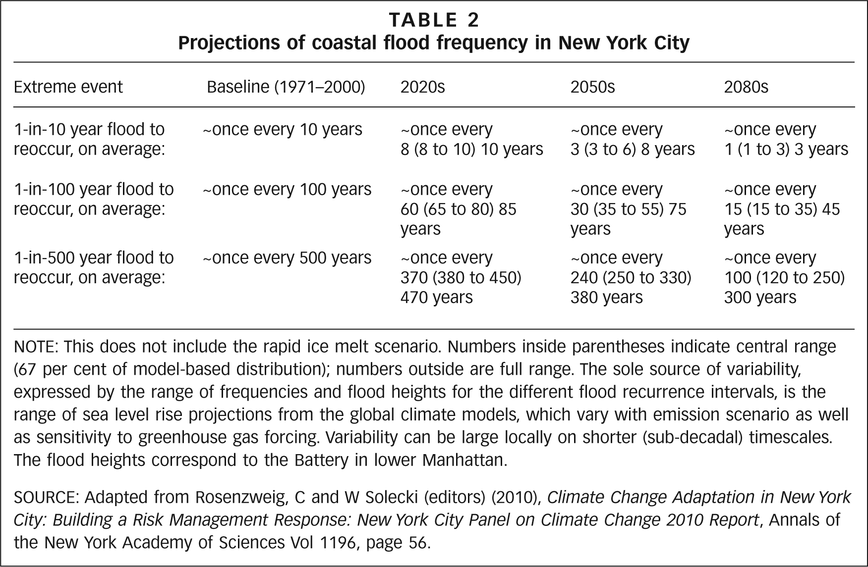
NOTE: This does not include the rapid ice melt scenario. Numbers inside parentheses indicate central range (67 per cent of model-based distribution); numbers outside are full range. The sole source of variability, expressed by the range of frequencies and flood heights for the different flood recurrence intervals, is the range of sea level rise projections from the global climate models, which vary with emission scenario as well as sensitivity to greenhouse gas forcing. Variability can be large locally on shorter (sub-decadal) timescales. The flood heights correspond to the Battery in lower Manhattan.
SOURCE: Adapted from Rosenzweig, C and W Solecki (editors) (2010), Climate Change Adaptation in New York City: Building a Risk Management Response: New York City Panel on Climate Change 2010 Report, Annals of the New York Academy of Sciences Vol 1196, page 56.
V. Development of Climate Change Adaptation Initiatives
Current climate change adaptation efforts in New York City build on and are a product of previous assessments and studies (Table 3). Also germane are lessons learned from responding to extreme events in the current climate that challenge the infrastructure. Within the metropolitan region, leading scientists, agency representatives and non-governmental organization members have been studying issues related to climate extremes and climate change for almost a decade and a half. The Metropolitan East Coast report entitled Climate Change and a Global City: The Potential Consequences of Climate Variability and Change (15) became an important benchmark study because it introduced new climate and sea level rise model results. In 2004, a climate change adaptation initiative was launched by the New York City Department of Environmental Protection (NYC DEP) – the agency responsible for the city’s water and wastewater systems, which supply and drain water for nine million people. Part of the 2004 initiative was the creation of the NYC DEP Climate Change Task Force, with the mission to ensure that all aspects of departmental planning take into account the potential risks of climate change on the city’s water supply, drainage and wastewater management systems and also integrate GHG emissions management to the greatest possible extent.
Climate change-related studies in New York City metropolitan region
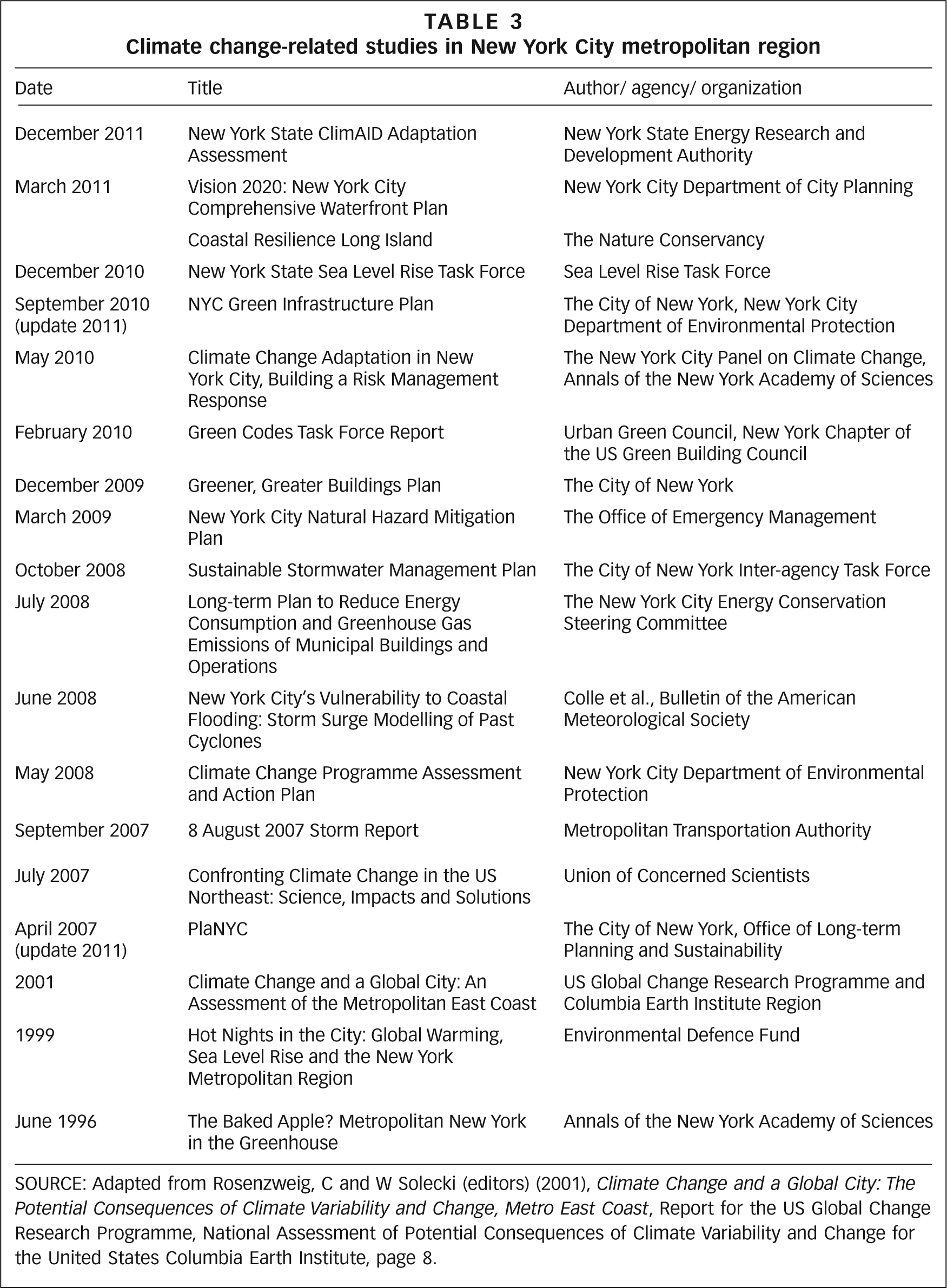
SOURCE: Adapted from Rosenzweig, C and W Solecki (editors) (2001), Climate Change and a Global City: The Potential Consequences of Climate Variability and Change, Metro East Coast, Report for the US Global Change Research Programme, National Assessment of Potential Consequences of Climate Variability and Change for the United States Columbia Earth Institute, page 8.
A significant major product of the NYC DEP task force was the Climate Change Assessment and Action Plan for the agency.(16) Since many climate change adaptations identified through this process help to increase the robustness of current systems managed by the agency, the NYC DEP task force brought immediate benefits by improving responses to current climate risk, such as managing episodes of intense precipitation in the upstate reservoirs. The work became the milestone and exemplar of work soon to be carried by other New York City agencies.
a. Current actions
When New York’s Mayor Michael Bloomberg created the Office of Long-term Planning and Sustainability in 2006, with the goal of developing a comprehensive plan to create a greener, more sustainable city, climate change planning in New York City and the surrounding region was given the potential to be significantly strengthened. Mitigating climate change was a central goal of the city’s comprehensive sustainability plan, PlaNYC 2030, released in 2007. The early focus of climate change mitigation in the PlaNYC effort was to set an ambitious goal of a 30 per cent reduction of GHG emissions from 2005 levels by 2030. In 2008, Bloomberg announced a long-term action plan to reduce energy consumption and GHG emissions from the city’s municipal buildings and operations by 30 per cent by 2017, even earlier than the citywide 2030 goal in PlaNYC. This would cut the city’s annual GHG output by almost 1.7 million metric tonnes and reduce peak demand for electricity by 220 megawatts.(17)
The PlaNYC work was expanded to include climate change adaptation, a response to the importance of doing both mitigation and adaptation simultaneously to protect the citizens and infrastructure of the city. This effort was furthered by the response to the 8 August 2007 extreme precipitation event and subway closings. A new goal of the PlaNYC effort was the creation in 2008 of an inter-agency Climate Change Adaptation Task Force to protect the city’s vital infrastructure in the face of a changing climate. The task force was charged with identifying climate change risks and opportunities for the city’s critical infrastructure and to develop coordinated adaptation strategies to address these risks. The task force consisted of approximately 40 city, regional public authorities and private companies that operate, maintain or regulate critical infrastructure in the region related to energy, transportation, water and waste, natural resources and communications. To support the work of the task force, the city convened a group of climate change experts as the New York City Panel on Climate Change (NPCC) to advise the city on climate change science, potential impacts, adaptation pathways and climate protection levels specific to the city’s critical infrastructure (Figure 1 shows a schematic of the city’s climate change action structure as of 2010).
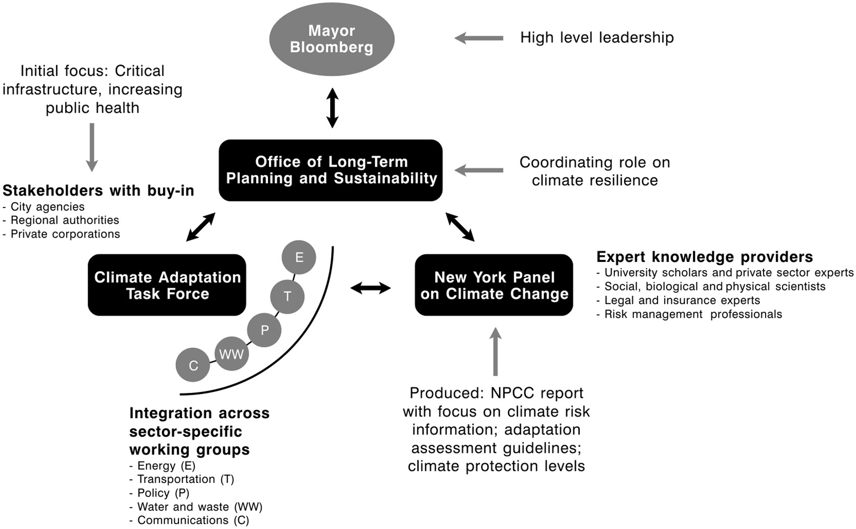
Schematic of New York City climate change action structure
The NPCC consists of climate change (and its impacts) scientists and legal, insurance and risk management experts, and serves as a technical advisory body. It was designed to function in an objective, unbiased manner, with a role similar to that of the Intergovernmental Panel on Climate Change (IPCC) on the international stage for nation states. The work of the NPCC is to ensure that the city’s adaptation efforts are based on sound science and a thorough understanding of climate change, its potential impacts and adaptation. To assist the city, the NPCC has analyzed climate change hazards, studied impacts on the critical infrastructure of New York City and developed a risk management framework for adaptation planning, which, in turn, has contributed to the development of the city’s climate change adaptation planning framework.(18)
A critical component of the NPCC’s work was to define climate protection levels, to address the effectiveness of current regulations and design standards related to sea level rise and storm surge, heat waves and inland flooding in the context of future climate change. Most important for the city is that, in order to maintain the current level of risk in the future, it will be necessary to adjust current building codes. In this way, climate change action has become integrated into the urbanization process by influencing a set of climate risk-related construction guidelines – i.e. how to build for increased frequency and intensity of precipitation and flooding events, heat waves and extreme wind events. In 2010, the city produced the Green Codes Task Force Report, which illustrated some of the goals of the climate protection levels by incorporating recommendations for increased GHG reductions and making the city’s building and infrastructure more resilient to climate change through building code adjustments.
The Adaptation Assessment Guidebook (AAG), another product of the NPCC, also directly connects to the urbanization process, as it describes a detailed process designed to help stakeholders create an inventory of their at-risk infrastructure and to develop adaptation strategies to address those risks. The steps outlined in the AAG are intended to become integral parts of ongoing risk management, maintenance and operation, and capital planning of the agencies and organizations that manage and operate critical infrastructure. The AAG includes three tools developed to aid the stakeholders in their adaptation planning process, namely infrastructure questionnaires, a risk matrix and a prioritization framework. The adaptation process was defined as a dynamic cycle of analysis and action followed by evaluation, further analysis and refinement (i.e. adjustment of the policies in response to the evaluation and further analysis).
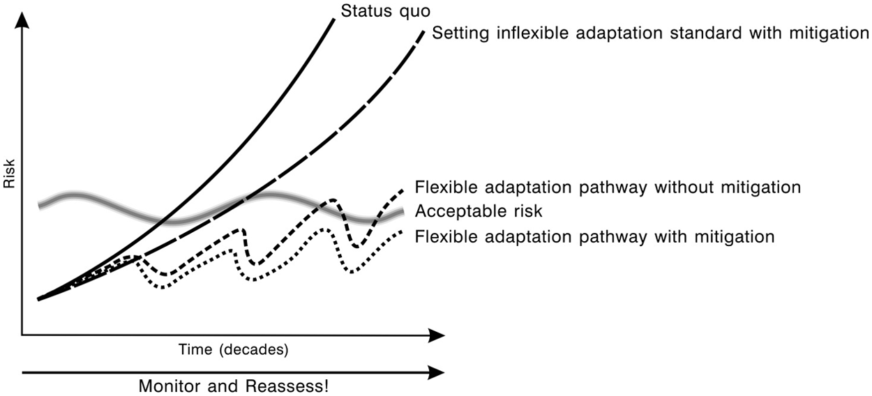
The adaptation approach developed by the NPCC fosters a “flexible adaptation pathways” approach – originally developed by the London TE2100.(19) “Flexible adaptation pathways” is a concept that encourages building climate change adaptation strategies that can be adjusted and modified over time to reflect the dynamic and ongoing climate change understanding (Figure 2). Flexible risk management strategies allow for adjustments as new information emerges on climate science and impacts and other unforeseen factors arise, to ensure they remain within an acceptable level of risk as that risk changes over time. The multi-dimensional climate risk management approach developed by the NPCC can be helpful in planning climate change adaptation in other sectors besides infrastructure, as well as being applicable to adaptation efforts in other cities and metropolitan regions.
Adaptive urbanization – climate risk management in cities, flexible adaptation pathways and interactive mitigation and adaptation
For New York City officials, adaptation planning and actions was initially focused on the various city agencies and the private and quasi-public entities that manage and control the city’s and the region’s critical infrastructure. Other specific programmes have emerged that include initiatives to promote adaptation of assets and populations in high risk locations (e.g. coastal sites) or of high risk populations (e.g. the elderly, institutionalized, immune compromised, young).
Many challenges to the forward movement of the city’s climate actions remain. One overall challenge is how to maintain focus on the issue when Bloomberg’s third and final four-year term expires on 1 January 2014. The Bloomberg administration has worked actively to institutionalize regulations; future administrations will need to update the ongoing urban sustainability efforts and periodically review progress towards the stated goals and objectives. Specific to climate change, the NPCC recommended that the city begin a process of sustained climate assessment that could incorporate new climate science and other findings on adaptation planning and implementation efforts. As of June 2012, the City Council of New York was preparing legislation to institutionalize the NPCC as an ongoing entity connected to city climate risk assessment and adaptation planning.
b. Climate change action example: investments in infrastructure in the coastal zone
Ongoing adaptation strategies for critical infrastructure in New York City can be best understood in the context of the coastal zone. These strategies can include both “hard” and “soft” measures.(20)
A possible long-term “hard measure” that has been suggested for the region would be storm surge barriers similar in concept to the Thames River barrier. Barriers in the New York City area would be designed to protect against high water levels that would get higher as sea level rises (and possibly also through increasing storm intensity).(23) The risk of future casualties and damage from hurricanes and nor’easters might be reduced by placing such structures on appropriate seaward sites. At present, storm surge barriers are under discussion as a possible way of dealing with the increasing risks of storm surge in New York City and the surrounding region in the era of climate change;(24) and they might be relevant as part of a long-term, staged response to rising sea levels and increased risk of flooding, especially if rising sea levels proceed at the higher end of the projections. “Hard measures” require extensive assessments, which include significant economic, environmental and social costs. Alternatives to such large-scale infrastructure also need to be assessed comparatively. New York City, for instance, could protect against some levels of surge with a set of smaller-scale measures (such as flood walls and reclaimed natural barriers), improved storm information and forecasting, to help infrastructure managers prepare for extreme events before they occur, and evacuation plans.
Other “soft” approaches include the enhancement and expansion of the existing “bluebelt” systems in the city,(26) such as the one promoting a stormwater management system covering about one-third of the borough of Staten Island. The programme preserves natural drainage corridors, including streams, ponds and other wetland areas. Preserving wetlands means that they are able to perform ecosystem service functions such as conveying, storing and filtering stormwater, while also providing open space and diverse wildlife habitats.
c. Synergies with disaster risk reduction, climate change adaptation and development
Direct connections between disaster risk reduction and climate adaptation strategies exist for New York. The city’s disaster risk reduction strategies were largely developed by the city’s Office of Emergency Management (OEM).(27) In the past decade, and at least partially spurred on by the 9/11 attack, the OEM has extensively expanded its emergency response planning and capacity to include the introduction of integrated GIS data products, vulnerability mapping efforts and emergency response materials in a wide diversity of languages in support of immigrant communities. Revised climate risk assessments and increased focus on climate adaptation has facilitated more active engagement by the disaster risk community in the city, especially with the recent emergence of climate resilience as a dominant policy discourse. This discourse allows for planning activities that enhance resilience to current and future climate risk conditions, with a specific focus on heat stress reduction, stormwater management via green infrastructure techniques, and updating of flood and storm surge mapping efforts with the acquisition of high resolution elevation data, a re-mapping of the flood hazard zones (the FEMA FIRM – Flood Insurance Rate Maps), the funding of the next generation of storm surge modelling, and the creation of a task force to create a new natural hazards risk model for the city.(28)
Much of the effort focuses on reducing the vulnerability of the general population and critical infrastructure to extreme events rather than enhancing the general livelihoods of the city’s poor and other highly at-risk populations, including the aged, young and immune compromised. Furthermore, disaster risk reduction (DRR) efforts do not focus on larger-scale economic development goals and other aspects of quality of life or livelihood improvement. Nor do they focus on larger-scale city or regional planning efforts. For example, almost all of the building land in the city has already been developed, and as a result there is little opportunity to steer new land development away from highly exposed sites such as storm surge inundation zones. This is coupled with the fact that private property rights within the state of New York specifically, and the US generally, are heavily protected, ensuring that it would be difficult to limit and/or eliminate the use of locations at risk from flooding or other climate-related hazards. Mechanisms that can have an impact on the economic accessibility of properties near the shore, and in turn can provide opportunities for DDR and climate change adaptation (CCA), include rising insurance premiums for flood protection or increased difficulty in getting insurance, as well as building codes designed to limit exposure, for instance by ensuring that any new construction is elevated to reduce storm surge damage.
d. Stakeholder engagement, funding and mandate for action
One of the most significant mechanisms for stakeholder engagement in New York City emerges from the NYC DEP Climate Change Adaptation Task Force, which includes representatives from all the relevant city agencies, quasi-public regional entities such as the Metropolitan Transportation Authority and the New York–New Jersey Port Authority, and selected private transportation (i.e. railroad companies) and telecommunications companies (e.g. mobile phone service providers). The task force provided a forum for middle level administrators and officials to discuss and debate new knowledge and information about climate change impacts and adaptation opportunities. The task force also enabled climate change discussion among stakeholders beyond the political boundaries of New York City, to include representatives of regional organizations such as commuter rail authorities and communications companies, thereby facilitating opportunities for regional coordination, with New York City as a leader.
Initial funding for climate change action in New York City has been largely provided by the city itself. Funding for the New York City Panel on Climate Change, however, was provided by the Rockefeller Foundation, with some additional resources provided as part of the PlaNYC 2030 effort. Other funding for the city’s adaptation efforts has drawn from a variety of its general revenue fund and capital investment sources for the maintenance and upgrade of critical infrastructure. For example, the NYC DEP, which maintains water supply for nine million consumers and a slightly lower number of sewerage customers, was, as of 2011, overseeing approximately US$ 14 billion of capital projects. The city has also created a US$ 1.5 billion green infrastructure initiative, which is designed to foster the development and construction of alternative and innovative stormwater management strategies to promote water retention and detention properties (i.e. structures that can hold immediate flood waters but drain soon after the event).(29)
VI. Outcomes and Important Lessons
The approach to governance under Mayor Bloomberg’s administration in New York has been largely technocratic and managerial. As such, the environmental and sustainability action in the city during his time in office has focused on the development of actions to respond to specific policy mandates and the articulation of quantitative and numerical success benchmarks and metrics. While the city has taken a leadership role on climate change action in the extended New York metropolitan region, it has no jurisdictional control over how the three US states (Connecticut, New Jersey and New York) and approximately 1,600 municipalities in the region respond to climate change. Nationally and internationally, the city has also presented as a leader in climate change action within several organizations, particularly via the Urban Sustainability Directors Network and the C40 organization.(30)
One could define the transferability of specific aspects of New York City climate actions as limited, because few cities globally have the institutional, human and capital resources to undertake the type of activities that have taken place in New York. However, many of the broader-scale elements of the city’s actions, particularly the focus on risk-based management and the use of criteria to define success metrics, have already been transferred to other cities in the US via the US National Research Council, Committee on America’s Climate Choices Panel Report,(31) and internationally as well.
Under Michael Bloomberg’s administration (2002 to present and due to end on 1 January 2014) and in the wake of the 9/11 attack, New York City has embarked on a dramatic re-visioning of the city, its security and its future. With respect to sustainability generally, the city set forth an ambitious effort to push forward many efforts under the umbrella of the PlaNYC 2030, which was first implemented in 2007 and updated in 2011. While broad in scope, the plan included a focus on climate change risks and adaptation. Below are some key messages and learning points that can be derived from these activities:
risk-based and metric responses to climate change-related risks; initial spotlight on critical infrastructure – e.g. roads, bridges, water supply, sewerage treatment, energy supply, communications, parks and open space; and estimation of risk level with new high resolution elevation data-associated flood hazard mapping;
engagement: the engagement of critical stakeholders and decision makers (i.e. city agency or infrastructure private company representatives) and resulting discussion of disaster risk reduction, climate change adaptation and resilience are important in securing their “buy-in” to the planning process.
The process has not been without difficulty and setbacks. Key challenges that can be seen as learning experiences include the following:
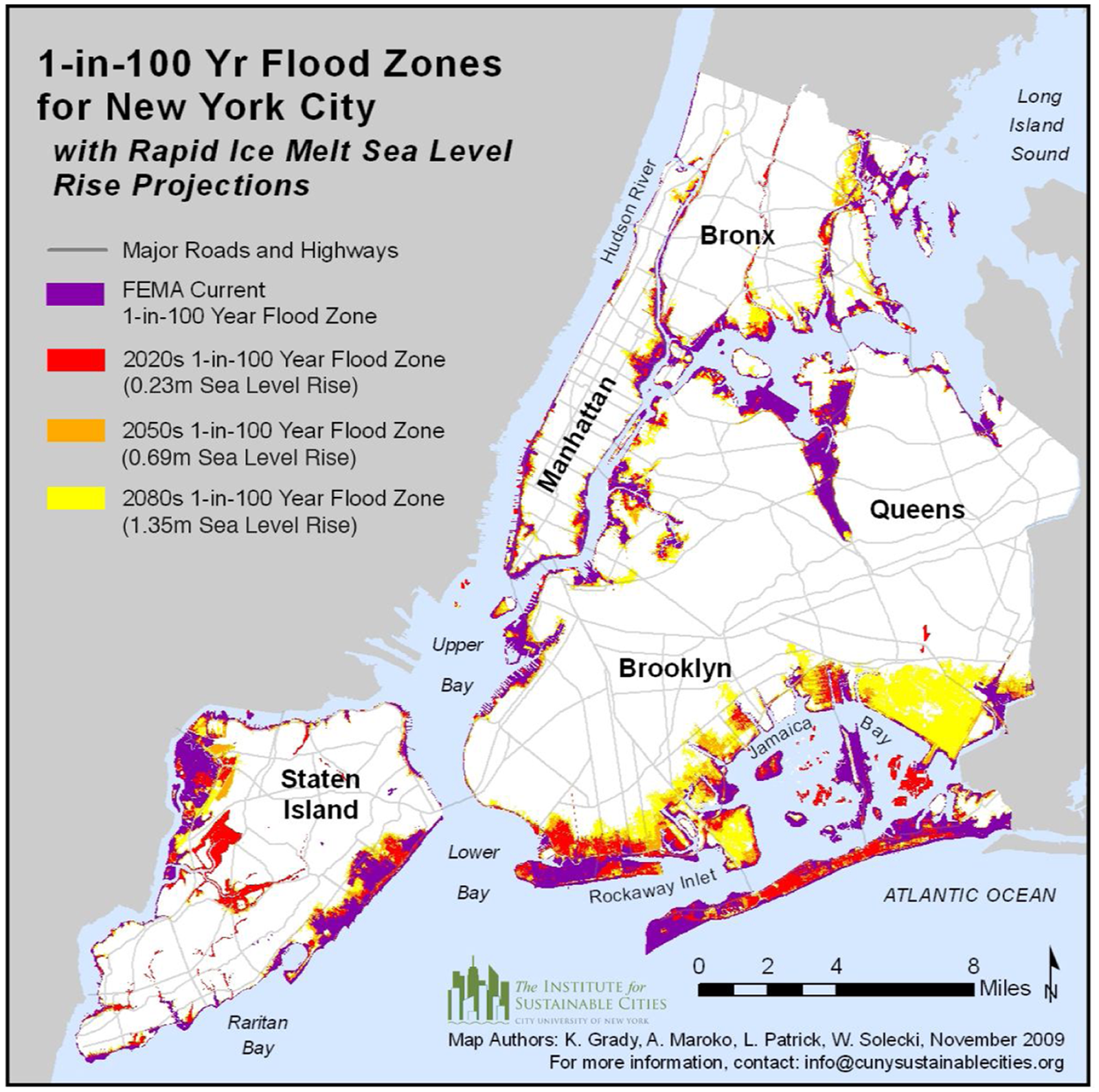
Citywide 1-in-100 year flood projections for the 2080s for “rapid ice melt” sea level rise scenario of 1.35 metres
Footnotes
1.
Rosenzweig, C and W Solecki (editors) (2010), Climate Change Adaptation in New York City: Building a Risk Management Response: New York City Panel on Climate Change 2010 Report, Annals of the New York Academy of Sciences Vol 1196, 354 pages.
2.
Rosenzweig, C, W Solecki, S A Hammer and S Mehrotra (2010), “Cities lead the way in climate change action”, Nature Vol 467, October, pages 909–911; also Solecki, W and L Patrick (2013 forthcoming), “Coming to town: climate change in New York City – adaptation, resilience and policy transitions”, in K O’Brien and E Selboe (editors), The Adaptive Challenge of Climate Change, Cambridge University Press.
3.
US Census (2011), New York City Population 2010, available at ![]() .
.
4.
Scobey, D M (2002), Empire City: The Making and Meaning of the New York City Landscape, Temple University Press, Philadelphia, 340 pages.
5.
Solecki, W, C Rosenzweig, S Hammer and S Mehrotra (2012 forthcoming), “Urbanization of climate change: impacts, vulnerabilities and transformation pathways”, in E Sclar (editor), Urban Transformations, Earthscan (in press).
6.
See reference 5.
7.
Rosenzweig C, D C Major, K Demong, C Stanton, R Horton and M Stults (2007), “Managing climate change risks in New York City’s water system: assessment and adaptation planning”, Mitigation and Adaptation Strategies for Global Change Vol 12, No 8, pages 1391–1409.
8.
See reference 1; also see reference 7.
9.
New York City Office of Emergency Management (2012), “Mayor Bloomberg updates New Yorkers on city response to Hurricane Irene”, Press Release PR-311-11, 28 August 2011, available at ![]() .
.
10.
See reference 9.
11.
Fisk, C (2012), “Graphical climatology of New York Central Park – daily temperatures, precipitation and snowfall (1876–present)”, available at ![]() .
.
12.
Bowman, M J, B A Colle and H Bowman (2012), “Storm surge modelling for the New York City region”, in J Aerts, W Botzen, M J Bowman, P J Ward and P Dircke (editors), Climate Adaptation and Flood Risk in Coastal Cities, Earthscan, New York, pages 93–122; also Solecki, W, C Rosenzweig, V Gornitz, R Horton, D Major, L Patrick and R Zimmerman (2012 forthcoming), “Climate change and infrastructure adaptation in coastal New York City”, in B Glavovic, R Kay, M Kelly and A Travers (editors), Climate Change and the Coastal Zone, Taylor & Francis.
13.
For a full description of methods of sea level rise projection development see Horton, R and C Rosenzweig (2010), “Climate risk information”, in C Rosenzweig and W Solecki (editors), Climate Change Adaptation in New York City: Building a Risk Management Response: New York City Panel on Climate Change 2010 Report, Annals of the New York Academy of Sciences Vol 1196, pages 145–226; also Horton, R, V Gornitz, D A Bader, A C Ruane, R Goldberg and C Rosenzweig (2011), “Climate hazard assessment for stakeholder adaptation planning in New York City”, Journal of Applied Meteorology and Climatology Vol 50, pages 2247–2266, available at doi: http://dx.doi.org/10.1175/2011JAMC2521.1; and Horton, R, V Gornitz, M Bowman and R Blake (2010), “Climate observations and projections”, in C Rosenzweig and W Solecki (editors), Climate Change Adaptation in New York City: Building a Risk Management Response: New York City Panel on Climate Change 2010 Report, Annals of the New York Academy of Sciences Vol 1196, pages 41–62.
14.
See, for example, Horton, R, C Herweijer, C Rosenzweig, J Liu, V Gornitz and A C Ruane (2008), “Sea level rise projections for current generation CGCMs based on the semi-empirical method”, Geophysical Research Letters Vol 35, 5 pages.
15.
Rosenzweig, C and W Solecki (editors) (2001), Climate Change and a Global City: The Potential Consequences of Climate Variability and Change, Metro East Coast, Report for the US Global Change Research Programme, National Assessment of Potential Consequences of Climate Variability and Change for the United States Columbia Earth Institute, 201 pages.
16.
17.
New York City (2007), PlaNYC 2030, available at ![]() .
.
18.
Major, D and M Grady (2010), “Adaptation assessment guidebook – Appendix B”, in C Rosenzweig and W Solecki (editors), Climate Change Adaptation in New York City: Building a Risk Management Response: New York City Panel on Climate Change 2010 Report, Annals of the New York Academy of Sciences Vol 1196, pages 229–292; also see reference 5; and see reference 12, ![]() forthcoming).
forthcoming).
19.
Lowe, J, T Reeder, K Horsburgh and V Bell (2009), “Using the new TE2100 science scenarios, City of London – the Thames estuary 2100 plan”, UK Environment Agency, Power Point presentation.
20.
The following discussion was adapted from Major and Grady (2010), see reference 18; also see reference 12, ![]() forthcoming).
forthcoming).
21.
Gornitz, V (2001), “Sea level rise and coasts”, in C Rosenzweig and W D Solecki (editors), Climate Change and a Global City: The Potential Consequences of Climate Variability and Change, Metro East Coast, Report for the US Global Change Research Programme, National Assessment of Potential Consequences of Climate Variability and Change for the United States Columbia Earth Institute, pages 21–46.
22.
Jacob, K H (2001), “Infrastructure”, in C Rosenzweig and W Solecki (editors), Climate Change and a Global City: the Potential Consequences of Climate Variability and Change, Metro East Coast, Report for the US Global Change Research Programme, National Assessment of Potential Consequences of Climate Variability and Change for the United States, Columbia Earth Institute, pages 47–65.
23.
Zimmerman, R and C Farris (2010), “Infrastructure impacts and adaptation challenges”, in C Rosenzweig and W Solecki (editors), Climate Change Adaptation in New York City: Building a Risk Management Response: New York City Panel on Climate Change 2010 Report, Annals of the New York Academy of Sciences Vol 1196, pages 63–85.
24.
Aerts, J, D C Major, M Bowman, P Dircke and M A Marfai (2009), Connecting Delta Cities: Coastal Cities, Flood Risk Management, and Adaptation to Climate Change, Free University of Amsterdam Press, Amsterdam, the Netherlands, 91 pages.
25.
See reference 21.
26.
See reference 16.
28.
Botzen, W and J Aerts (2012), “The National Flood Insurance Programme (NFIP) and climate resilient waterfront development in New York City”, in J Aerts, W Botzen, M J Bowman, P J Ward and P Dircke (editors), Climate Adaptation and Flood Risk in Coastal Cities, Earthscan, New York, pages 165–196; also see reference 12, ![]() .
.
31.
US National Research Council, Committee on America’s Climate Choices (2011), America’s Climate Choices, Final Report, National Academies Press, Washington DC, 144 pages.