
Abstract
This paper describes the use of Global Positioning System (GPS) devices to map informal settlements in Cuttack, India in ways that enhance and support residents’ participation in the data collection and planning process. Rather than relying on remote sensing to identify informal settlement locations, each settlement is visited individually by a mapping team comprised of community leaders and NGO staff. The mapping team meets with settlement residents to develop a detailed settlement profile and map the settlement boundary using a GPS device. This process has helped to open and sustain a dialogue between the residents of informal settlements and city government around “slum” upgrading, and has influenced the use of a central government fund to support local upgrading plans.
I. Introduction
“It is important for policy makers to remember that the focus should remain on people, organizations and processes rather than the technologies themselves.”(1)
In most cities in India, a high proportion of the population lives in settlements or “slums”(2) that have both poor quality housing and inadequate provision for water, sanitation and drainage infrastructure and services.(3) These conditions are often related to a condition of illegality or lack of formal land tenure. The government of India has made many attempts to encourage state and city governments to eradicate, regularize and redevelop such settlements by subsidizing programmes to provide formal housing for the urban poor. Over the past several decades, these programmes have evolved from a focus mainly on mass evictions and relocations of slum and pavement dwellers to more support for in situ redevelopment of houses and comprehensive settlement upgrading, although mass evictions still take place.(4) Policies have also evolved to encourage and mandate greater inclusion in these so-called slum improvement schemes on the part of the urban poor and the NGOs that work with them. These shifts are by no means disconnected; the failures of older projects were linked to a lack of knowledge about the demand-side of slum upgrading and resettlement.(5) Increasing participation and inclusion led to projects that challenged existing practices and norms, and helped change the attitude and direction of government interventions in informal settlements.
Yet funding from central government and legislative changes are often insufficient to achieve real participation in these projects. A partnership of three Indian organizations, known as the Alliance (Box 1), has worked with the government to implement these programmes, largely to demonstrate shortcomings in existing approaches, articulate alternative methods and influence new or modified policies. A key challenge the Alliance faces is to engage with the state in a way that does not compromise its values and the priorities of its member organizations, but to further its agenda for building the capacity of the urban poor and encourage institutional change that serves them. The partners in the Alliance achieve this by engaging in projects and processes that are parallel to, but different from, prescribed government processes. Indian anthropologist Arjun Appadurai has branded this strategy “deep democracy”, because it creates relationships between government and civil society that have both a meaningful depth and the reach to impact other stakeholders.(6) Deep democracy is not a strategy meant to weaken or undermine the state, but one that tests the limits of public policy and forces public agencies to be more inclusive of the urban poor.
In 2009, the Alliance began scaling up its strategy to support community-led upgrading in anticipation of a new national housing programme, Rajiv Awas Yojana (RAY). RAY follows many previous government programmes that addressed slums, but has particular importance in that the support it offers state and city governments to achieve “slum-free” cities focuses far more than its predecessors on in situ upgrading and tenure security for those living in informal settlements. It also stipulates that state or municipal governments must engage community-based and other civil society organizations in developing “slum-free” cities. But RAY includes complex requirements for technology-laden data collection and analysis before local plans and funding can be approved. In response, the Alliance has been testing the use of digital tools for its own data collection and analysis in the city of Cuttack, Orissa. The Alliance’s Participatory Settlement Mapping Project has two central goals: to set a precedent for a community-based implementation of RAY; and to empower the urban poor with new knowledge and tools to help them articulate their needs and demands using digital media.
However, because this project employs new technology, the Alliance faces several challenges in pursuit of its goals. First, the fact that the mapping is undertaken by community-based organizations does not mean it is inherently participatory. The Alliance’s philosophy is that all poor people, whether federation leaders, Mahila Milan members or unaffiliated residents, should be able to contribute and participate in its projects and processes. This is normally achieved by bringing all interested stakeholders into the project through the Alliance’s grassroots network and allowing them to ask questions, contribute ideas and make decisions. But bringing new technology into the mix means that members and groups with less understanding of the technology may have greater difficulty understanding and contributing to the process.
A second and related challenge is replication. With India’s slum population projected to surpass 90 million in 2011, India’s social sector needs solutions to urban poverty, homelessness and vulnerability that are replicable and scalable.(7) In his essay on deep democracy, Appadurai notes that the Alliance is dedicated to “…methods of organization, mobilization, teaching and learning that build on what the poor themselves know and understand”,(8) rather than focusing on projects and “projectization”, which have short-term, local views of change. To avoid having only short-term and limited impacts, the Participatory Settlement Mapping Project (PSMP) must develop from a local initiative into a process that can be replicated in cities and smaller urban centres nationwide.
Finally, the PSMP will challenge the Alliance to push the boundaries of its relations with government. As public agencies face increasing pressure to redesign their internal processes around new data-gathering technology, they will likely lose focus on the importance of qualitative participation from stakeholders. Although information technology is not inherently objective, past studies have shown that administrators often believe it can improve upon or replace subjective human interaction in decision-making processes.(9) The Alliance must demonstrate an alternative, grassroots process that satisfies government agencies’ technological demands and facilitates increased interaction and participation.
Nevertheless, because the PSMP is rooted in an existing grassroots network with model processes for participation, dissemination and negotiation, it has already made remarkable progress towards overcoming these challenges to achieve its goals. Moreover, by building the capacity of the urban poor to manage their own development, the PSMP has increased the quality of participation in RAY’s implementation in ways that policy provisions or legislative norms cannot.
In an age where service provision by NGOs, CBOs and public−private partnerships has become omnipresent, it is important to understand how best to facilitate meaningful participation that engages with and influences institutional processes rather than reinforcing the existing government−beneficiary relationship. This paper examines the Alliance’s PSMP from a perspective that supports dialogue and contestation between grassroots and legislative approaches to development as a means of achieving participation in local decision-making.
II. The Legislative Approach
From 2001 to 2005, most government of India subsidy-based housing projects came under the Valmiki Ambedkar Awas Yojana (VAMBAY) programme. This programme allocated Rs 2,000 crores to state governments for low-cost housing for the poor. State legislators allocated subsidies to various cities within their states, after which municipalities identified the households and communities that would be eligible for subsidized housing. The programme had no provision for land acquisition, leaving municipalities to choose between upgrading homes in less vulnerable settlements that already had secure tenure or relocating families to newly constructed homes on land owned by the municipality. VAMBAY lacked institutional processes for participation and grievance redress, resulting in many involuntary relocation projects.
VAMBAY included a provision for the “involvement of beneficiaries” in the construction of new housing units, mainly as a way to lower costs and promote efficiency.(10) The programme also suggested that “…guidance and monitoring of construction can be entrusted to [NGOs].”(11) However, the central government did not expect the state and city governments that were meant to implement these initiatives to defer to NGOs, CBOs or residents for comments on the beneficiary selection process, feedback on housing designs or any other contributions to planning and decision-making. They were, instead, relegated to carrying out the directives and designs of the municipalities.
In 2005, the government of India consolidated all housing subsidy programmes under the Jawaharlal Nehru National Urban Renewal Mission (JNNURM) within the Ministry of Housing and Urban Poverty Alleviation (MoHUPA). The JNNURM Basic Services to the Urban Poor (BSUP) sub-mission provided subsidies to states and municipalities to implement shelter, basic services and other civic amenity projects on behalf of slum dwellers.(12) BSUP projects are funded by contributions from the central government, the state and municipal governments and a 10−12 per cent contribution from beneficiaries. Municipalities were required to submit city development plans to the ministry for approval prior to accessing subsidies to fund specific projects. A main objective of the programme was to improve local urban governance and the capacity of local and state agencies to undertake more comprehensive and proactive planning activities. These mandated activities included mapping the location of all slums in Geographic Information Systems (GIS) and surveying existing infrastructure and basic amenities within each slum. Municipalities were meant to use the information to prioritize slums for upgrading.
One component of the guidelines tailored towards improving urban governance required that states adopt community participation laws to ensure a participatory process.(13) However, 18 states, including Orissa, never adopted this legislation.(14) Because participation was not institutionalized at the state level, MoHUPA used its authority over bid package approvals to ensure that BSUP projects included NGO and community participation. Bids and contracts encouraged participation and representation in a number of different ways: by adding experience working with slum communities to the list of criteria for awarding contracts; by procuring implementation services directly from NGOs representing slum dwellers; and/or by requiring contractors to “…carry out the work through social mobilization, participation and … consent of the beneficiary slum families.”(15) Yet because requirements for participation and representation were only enforced during the construction phase of most BSUP projects, the eligibility lists, house designs, specifications and terms and conditions were already fully developed and finalized by the time NGOs and slum dwellers were invited to participate and bid on projects. NGO and CBO participation in BSUP projects, like those under VAMBAY, had no place in the decision-making process.
Although MoHUPA had encouraged participation in the planning and decision-making phase, during the formation of individual city development plans, most states and municipalities did not invite the involvement of civil society. A meeting of the technical advisory group to JNNURM, convened in 2006 to discuss and evaluate civil society participation in the programme, concluded that:
“The rigid attitude [and] mindset of the state urban officials is a major obstacle for having any kind of worthwhile collaboration with [CBOs/NGOs]…. State government officials believe that [CBOs/NGOs] don’t possess any technical competencies so they cannot chip-in in any planning or policy-making processes.”(16)
Thus, a perceived lack of technical knowledge became grounds for excluding the urban poor and slum residents from influencing the course of development in their own neighbourhoods and cities. Without an enforcement mechanism, MoHUPA could not ensure participation at the local level.
In 2009, the newly elected national administration unveiled its newest programme for urban development and slum rehabilitation, namely Rajiv Awas Yojana (RAY). Throughout the year, MoHUPA held a series of meetings with the housing ministers of various state governments as well as representatives of NGOs and CBOs working on housing and sanitation for the urban poor. These meetings were designed to refine RAY based on the lessons learned from the shortcomings of previous programmes. Policy makers attempted to reconcile the need of the poor for low-cost, socially appropriate housing with the ministry’s need to increase the scale of regularization. Ministers acknowledged that upgrading programmes must creatively blend resources to make funding go further and include more beneficiaries. All agreed that a process involving NGOs and CBOs at every stage would ensure a more successful outcome and more efficient use of resources. Thus, RAY conceived a participatory process to develop city development plans, including plans for the upgrading and tenure security of all slums.
In early 2010, MoHUPA finalized the RAY policy and issued guidelines to cities for generating their slum-free city plans – a pre-requisite for receiving RAY funds. These plans are intended to make up for the failure of municipalities to address slums comprehensively under JNNURM−BSUP. Working at a city scale to develop these plans also forces municipalities to find housing solutions for all slums, including those with the most pressing and serious problems, rather than prioritizing better-off slums for which tenure security is not an issue.
Building on the provisions of JNNURM, RAY requires municipalities to conduct household level surveys, create cadastral maps of all slums and enter and integrate the data to create GIS-based “Slum Information Systems” to inform and prepare their slum-free city plans and individual project plans.(17) RAY also stipulates that state and municipal agencies should:
“…identif[y] and engag[e] Lead NGO/CBOs to guide and anchor community mobilization for the purpose of slum survey…. These Lead NGOs/CBOs should also be associated in slum survey operations and dialogues for preparation of slum level redevelopment plans.”(18)
The policy document continues:
“…decision-making should necessarily be done with the involvement of the community.”(19)
Unlike JNNURM−BSUP, which only required participation during the construction phase, RAY makes a concerted effort to encourage and require participation of NGOs and CBOs in planning and decision-making.
Yet the unwieldy technical requirements of RAY threaten to exclude civil society organizations from meaningful participation in planning and decision-making, just as the technical requirements of BSUP became the pretext for their exclusion from decision-making in the previous programme. Using GIS as a basis for decision-making can limit the scope of negotiation to that pre-selected by GIS experts.(20) In such situations, participants would only be able to comment or give feedback on seemingly objective, pre-defined data. Using GIS can also mislead participants as to the subjective nature of the information, by presenting it in a format that uses coordinates, distance measurements and other quantitative information to present information as precise and accurate.(21) GIS does not display
When government is the sole user or mediator, GIS can become a tool of coercion rather than participatory decision-making. A study by Walsham and Sahay(23) found that in India, local level administrators who had adopted GIS technology for local planning continued to base decision-making on existing political processes. Instead of using GIS to inform decisions or facilitate greater participation, administrators used it to legitimate their decisions when presenting them to the public. Civil society would be hard-pressed to challenge these decisions or present alternatives in a similar format without access to the same software or data. A policy that encourages the use of GIS in planning, without explicit requirements for transparency and participation, can only undermine civil society’s capacity to participate in the decision-making process.
The survey methodology recommended by the RAY GIS guidelines emphasizes inherently top-down techniques that would compound problems of data inaccessibility with problems of inaccuracy. The guidelines recommend mapping slums through remote sensing, a tool whereby a computer identifies the colour of cells in a satellite image and assigns them to land cover categories. The guidelines explain that: “…remote sensing is a technique used to derive information about… objects without direct physical contact.”(24) This approach would mean that a government GIS specialist or a private company could have the authority to determine slum boundary locations without ever having to enter a slum or interact with its residents.
Although RAY proclaims that local governments should include NGOs and CBOs in decision-making, the process through which this should be accomplished is not articulated, nor is it immediately clear. How will the GIS database be shared with NGOs and CBOs to inform their decisions when they do not have access to the same software or data? How can the urban poor ensure that the information that technical professionals have collected about their settlements is accurate if they have neither access to the technical tools nor knowledge of how to use them? The GIS guidelines for RAY offer more than 300 pages of explanation about technical processes, but do not even begin to answer these important questions about the social and political process.(25)
III. The Grassroots-Driven Approach
For more than two decades, the Alliance has practiced and promoted alternative approaches to the Indian government’s urban development programmes. Appadurai’s theory of deep democracy contends that the Alliance’s bottom-up approach, which engages the slum residents in action, experimentation and precedent setting, is strategic in that it forces a discussion and negotiation with government along the ambiguous, grey edges of public policy.(26) The Alliance’s alternative processes create a link with government through which meaningful participation can occur. But these alternative processes are also strategic because they support the involvement and capacity building of the urban poor, both as participants and as decision makers.(27)
One such approach, the engagement of “slum” residents in self-enumeration, has been established as an effective alternative to professionally administered surveys in India. The process of the urban poor enumerating, surveying and mapping their own communities is well documented as a means to capacity building and influencing institutional practices.(28) Self-enumerations allow communities of the urban poor to generate and control their own information, upsetting the knowledge hierarchy and putting communities in a better position to negotiate with government and outside agencies. Slum residents have more chance of success in negotiations with government if they can bring information and evidence to the table.
Researchers, donors and local governments approach the Alliance to gain access to the information from community-managed enumerations, allowing the Alliance and its constituents to determine when and under what conditions to share its data. Internally, as communities collect information about themselves, they develop a new understanding of their own needs and priorities and build their capacity to develop their own solutions to those needs. The process is disseminated through learning exchanges, in which different community, city or state level federations meet with each other to demonstrate new strategies, share ideas and educate new organizations of the urban poor.(29) To date, the Alliance has enumerated more than 4,000 settlements and eight million people.
By demonstrating a separate, effective process for enumeration, the Alliance has been able to challenge the legitimacy of the government’s information-gathering process and push for direct changes to existing protocol. Such forms of contestation and negotiation can also produce institutional transformations that better serve the urban poor.(30) The challenge of the Alliance’s self-enumeration process has led to new policies recommending public agencies to contract NGOs and CBOs for the purpose of slum surveys in slum rehabilitation projects.(31)
With the Indian government’s increasing use of information technology to aid local planning processes, a major concern is that government will increasingly look to private contractors to digitize and maintain official databases. Private contractors normally seek such work to increase their bottom lines. By contrast, the Alliance’s primary aim is to collect highly accurate data and use it to facilitate a more inclusive decision-making process. Should private contractors become an intermediary between grassroots groups and government, these groups and the NGOs they work with will lose their power to negotiate with government. The role of NGOs and CBOs would be reduced to one of data extraction rather than a two-way information exchange.(32)
By contrast, transparency and accountability can be increased if NGOs and CBOs adopt the intermediary role of data compilation and digitization – particularly if those civil society groups build the capacity of the poor to collect and use the information. GIS has also been shown to improve users’ ability to interpret complex information, and by extension to improve the quality of spatial decision-making.(33) Similarly, inter-organizational partnerships in GIS use are found to encourage greater transparency, economies of scale and a better quality of public service provision.(34) The key element in reaping these benefits from GIS use is an empowered “user” – one who can contribute to, understand and glean information from a GIS database. Projects that enable the urban poor to adopt advanced mapping techniques and GIS technology have been shown to create more transparent processes and actually facilitate participatory decision-making.(35)
Consequently, in order for the urban poor, their organizations and the NGOs that work with them to have a role in decision-making within RAY, key individuals in these groups must become GIS users. In the same way that community-based enumerations act as a check on government-produced surveys, community-based mapping can provide an alternative visualization of city and community space that challenges the assumptions of the municipal mapping process. Furthermore, the process of creating maps can help the urban poor develop a familiarity with maps and computer-based mapping tools, allowing them to evaluate externally produced maps more confidently, articulate their thoughts and needs in terms of mapping tools and negotiate more knowledgeably with government.
For these reasons, the Alliance resolved to set a precedent for a grassroots-driven, participatory implementation of RAY. Instead of waiting for the government to set up a bid package for slum enumerations and mapping as per the RAY guidelines, the Alliance initiated a parallel process based on its existing self-enumeration methodology.
IV. The Participatory Settlement Mapping Project (Psmp)
a. Background
Cuttack, a mid-size city on Orissa’s eastern coast with around 600,000 inhabitants, became the laboratory for this initiative. Situated just 30 kilometres from Bhubaneswar, the state capital, Cuttack is part of the rapidly growing Bhubaneswar–Cuttack metropolitan region. However, there is limited space within Cuttack to accommodate physical urban growth because the city is bounded by two major rivers.
New growth and physical constraints put two familiar pressures on the urban poor in Cuttack. First, land prices for areas within and close to the city centre are not affordable by the poor. Instead of purchasing land for housing in the formal market, the urban poor resort to squatting on government-owned land or to building their homes in high risk settlements near the riverbed. Second, as land values continue to rise, the urban poor will face increasing risks of eviction and of displacement outside the city to make way for more profitable land uses.
The Alliance saw the opportunity to intervene early on in this process by initiating the PSMP in Cuttack and providing the urban poor with a chance to define and regularize their settlements before evictions escalate. The Cuttack federation and Mahila Milan leaders already had experience conducting settlement level surveys and negotiating for land and tenure security with the Cuttack municipal corporation during several previous housing projects. One such project, the Ring Road Resettlement Project, came under the JNNURM programme and involved negotiating for land to resettle communities living on the riverbank to land within the city. The municipal corporation had originally designated land outside the city limit for the relocation, but the communities feared that moving far from the downtown marketplaces would mean losing their source of income. The Cuttack federation helped the communities to successfully negotiate for a vacant site within the city core, and the plan was eventually supported by the local commissioner and collector.
Through this project, the federation built up a working relationship with the municipal corporation that formed the basis for implementing the PSMP. The municipal corporation intended to develop a slum-free city plan to gain access to funding through RAY. Developing a participatory planning process in Cuttack would allow the federation to engage the municipality while it was initiating its own process to plan for slum regularization and upgrading. Thus, there were good reasons for the Alliance to begin its settlement mapping efforts in Cuttack.
In April 2010, a SPARC technical assistance team met with federation leaders in Orissa for an introductory discussion about RAY and the technical options for implementing a citywide settlement mapping project. SPARC’s partner NGO in Orissa, the Urban Development Resource Centre (UDRC), supported the project by facilitating the discussion in Oriya and Hindi, as well as providing staff assistance, a meeting space and a computer work station. The Orissa federation had nominated and selected volunteers from within its ranks to be on a mapping team that included one UDRC staff member, two experienced federation leaders from Cuttack and one new federation member from Cuttack. The SPARC technical assistance team and the mapping team worked together through trial and error to create a mapping process that was both practicable and inclusive.
They determined that, as a first step, collecting comprehensive citywide information for each slum household as required by RAY was both unrealistic and undesirable. Slum populations are highly dynamic. Demographics, ownership and tenancy change rapidly, usually without legal record, so any comprehensive survey can become outdated within weeks or months. Detailed cadastral maps and surveys that collect data from each household are both costly and time consuming. Although RAY seeks to overcome these constraints by providing funding for a preliminary household level survey, there is no funding for follow-ups to update the information prior to engaging a project at a specific site. Nor does RAY address the significant human resource constraints that make it difficult to update household level information on a regular basis. With more than 300 slums in Cuttack, the task is daunting.(36)
The Alliance decided to take a phase-wide approach whereby settlement level surveys in all informal settlements would provide the basis for a citywide plan and prioritization, after which household surveys could be undertaken in settlements where upgrading and infrastructure investment were planned. This has become the standard process for the PSMP. First, baseline information is collected at the
The second,
b. The mapping process
The mapping team visits a few settlements each day to conduct the settlement level survey and prepare a boundary map. First, the team meets with community leaders and residents to fill out a settlement profile form. Because the federation leaders on the mapping team have worked with community leaders during past enumeration activities, and are themselves residents of slum communities in Cuttack, they have established working relationships that create a collegial, rather than adversarial, environment for information collection. The community leaders and residents know everything about the inner workings of their communities and are readily able to provide the enumeration information to the federation leaders, who record the responses with pencil and paper. The information needed for the settlement profile is quickly collected through group discussions.
The mapping team then explains to the leaders why they need to mark the settlement’s boundaries on a map, how this is done with the hand-held Global Positioning Systems (GPS) device, and what the information will eventually look like on a map (Photos 1 and 2). Usually, the mapping team will draw hypothetical waypoints(37) and boundary lines on a slip of paper to show the community leaders why they need to walk all the way round the settlement with the GPS, even where fences, drainage canals and other barriers may stand in the way. They ask the community leaders to take them to a starting point along the boundary of the settlement and to lead them around the boundary. The team member using the GPS device marks waypoints every three to five metres and at every turn. If there are physical barriers to walking fully around the boundary then the team notes down which waypoints they have marked inside the settlement and which they have marked outside. They correct the boundary line later in GIS by looking for the physical barriers in aerial images.
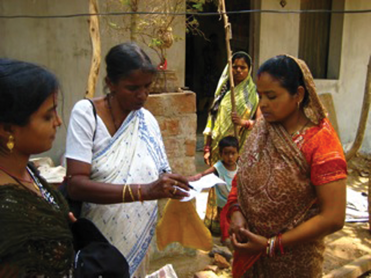
Mahila Milan members Priyadarsini and Sephali explain the project to a settlement leader
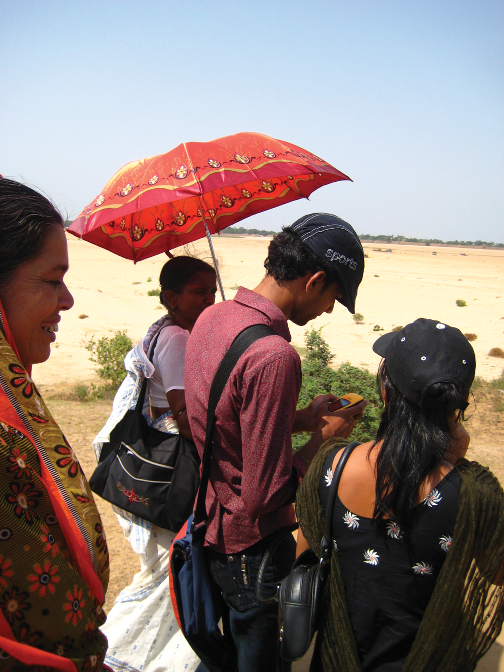
The mapping team marks out the boundary of a settlement using the GPS device
The mapping team imports the waypoint data from the GPS device to Google Earth (Photo 3) and connects the waypoints using the “path tool”.(38) When a path is closed, Google Earth translates the boundary line into a polygon – a shape on the map representing the land area of the settlement.
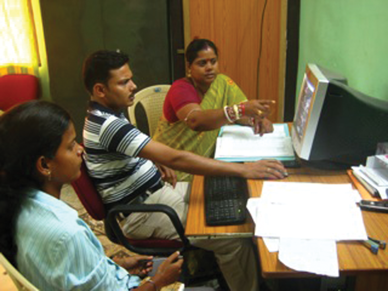
The mapping team inputs GPS data to Google Earth in the UDRC office
The mapping team exports and sends these files to the SPARC technical assistance team, which converts them to shapefiles and joins them to the settlement profile data in Quantum GIS (QGIS) (Photos 4 and 5). Thus, each settlement in the boundary map is linked to tabular information (e.g. population, number of structures, risk of flooding) that describes it. The QGIS system can be used to create simple maps showing, for instance, which settlements are at risk of flooding, or more complex maps showing which settlements are both without land tenure and at risk of flooding. Different map compositions can be used to identify and highlight prioritized settlements on the basis of criteria developed by the federation and community leaders from Cuttack.
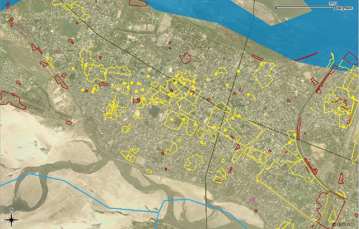
QGIS slum database showing settlements located on land held by residents
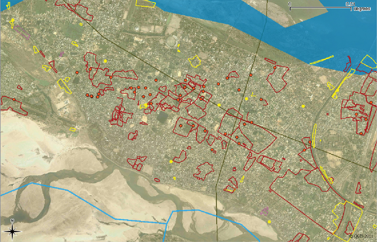
QGIS slum database showing settlements located on privately held land
There were two motivations behind the Alliance’s choice of this methodology. First, Cuttack is not a fully built-out city and there are still many open spaces used for communal planting, grazing and washing, so it is difficult to determine boundary lines using only aerial imagery interpretation or remote sensing. While some informal structures are identifiable from aerial imagery due to the colour of tarpaulins and plastic bags used for roofing materials, there is no way of knowing whether a given settlement includes nearby open spaces or brick and concrete structures without talking to residents of that settlement. In addition, while the remote sensing methodology recommended by MoHUPA cannot differentiate between adjacent but separate slum communities, on-the-ground boundary marking can. Using a GPS device to mark the boundaries thus removes many of the problems or inaccuracies that can result with remote sensing and aerial image interpretation.
More importantly, using GPS on the ground for settlement mapping with the residents facilitates the very interactions that are central to a grassroots planning strategy. Rather than sitting at computers, drawing boundaries in GIS as any private contractor or technical team can do, the mapping team visits each settlement individually and meets with the community leaders for permission to map the boundary. Inevitably, the community leaders and residents question the team about why they have come. Who wants the information? What will we gain from marking the boundary? Everyone wants to know what the funny looking GPS device is for. Is it a mobile phone? How does it work? This gives the mapping team the chance to explain the project, the purpose of the project, and how the GPS works. Involving the community leaders ensures more accuracy and a higher degree of community participation. Ensuring the leaders and residents understand the purpose of the project lays the foundations for their participation later on, in the decision-making stage.
Benefits of this grassroots process are already visible. During the field mapping, the Mahila Milan and federation leaders found 77 slums that were not included in the official Cuttack slum list, bringing the total number of settlements to 340. These 77 settlements would not have been considered for RAY funding had they not been identified through the grassroots mapping process. The mapping team also found that some settlements on the official list already had high quality housing and infrastructure, suggesting that they had been included on the list for political reasons. Visiting the settlements to ground-truth the official list, complete a baseline profile and create a boundary map proved an easy way to ascertain the range of needs of the various communities; an understanding that neither the Alliance nor the municipality would have gained through RAY’s prescribed remote-sensing approach.
c. Challenges
As noted earlier, use of GIS for planning applications can create confusion about facts and interpretations by failing to show how data was gathered and why certain data was selected for analysis. The Alliance has addressed these issues by incorporating participation into the development and use of the GIS database and data gathering. When collecting settlement data, the mapping team uses existing settlement profile formats developed by the federation members with their respective communities. The data fields in the resulting GIS are therefore those fields that selected communities of the urban poor have deemed most important to them. Similarly, the Alliance conducts its mapping exercises on-the-ground with settlement leaders, ensuring that they have at least a basic understanding of how the data is gathered. Thus, when the time comes for the federation and community members to discuss planning options using GIS-based maps, they already know the
Moving beyond this basic understanding proved to be one of the greatest challenges of the project. Federation members received extensive training in using the GPS device and creating boundary maps in Google Earth, but many of the older leaders remained uncomfortable with the new technology and deferred to younger members to use the GPS and the computer. The younger members became proficient but the older leaders only gained a cursory understanding of how the technology worked. The mapping team always consisted of at least one older leader and a younger member to ensure that both ranges of experience would inform the data collection process.
Resistance to the project from various settlements’ residents, for fear that the information would be misused, was in most cases quelled when the mapping team explained the Alliance’s intentions for the project. The older federation leaders’ experience in communicating the Alliance’s mission coupled with the younger members’ understanding of the mapping process enabled the team to bring most communities on board the project. The mapping team took a single waypoint reading on the GPS for the 44 settlements that did not want to be included in the project. The settlement profile information was attached to these points, rather than a boundary line, in QGIS.
A second challenge identified at the outset of the PSMP was scalability – whether the project would be able to evolve into a much larger scale process in other cities. Within the Alliance, dissemination and replication are accomplished through peer to peer learning exchanges, where communities learn from each other how best to design surveys and collect settlement and household information (Photo 6). Although the digital aspect requires additional technical training, it is building upon existing knowledge, rituals and networks.
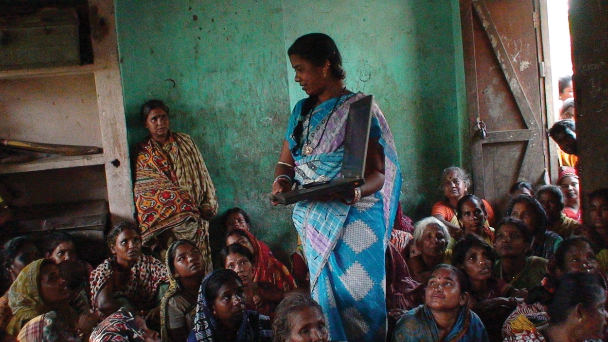
Federation leader Nayana explains the mapping project to Mahila Milan women during a learning exchange
The PSMP spurred four learning exchanges between the mapping team in Cuttack and slum dwellers federations from other cities in Orissa, who will try to replicate this process in their own cities. In addition, the Cuttack federation hosted an exchange with federation leaders from Pune and Bangalore, where the Alliance is piloting other mapping strategies. The teams worked together to map some of the more densely populated settlements by adopting the Bangalore team’s strategy of labelling hand-drawn maps with every name and spelling variation of each community within the larger settlement before marking waypoints for the digital map.
The learning and capacity building that came out of addressing these myriad challenges will continue to strengthen the project and inform the mapping process in other cities. The Alliance’s existing peer exchange network is already disseminating mapping methodology to other communities and building the capacity of those communities to adapt their mapping processes to more complex planning areas.
V. Dialogue with Government
The final challenge, and perhaps the most significant, is engaging with government in a constructive dialogue to improve its own mapping and surveying activities. The PSMP cannot be successful on its own, without influencing the process that it seeks to challenge. While the RAY programme may urge local governments to include CBOs and NGOs in slum enumerations and development plans, the implementing agency MoHUPA does not have the power to hold state or city governments accountable for being inclusionary. Thus, any real participatory decision-making process under RAY must necessarily result from a dialogue between local governments and slum residents and their organizations.
Bishwapriya Sanyal has examined relationships between government agencies and NGOs that work together on projects despite conflicting approaches and perceptions, and described the partnerships as a form of antagonistic cooperation. He finds that these partnerships persist because both parties can gain from working together despite their differing views and attitudes.(39) The PSMP was already of great interest to the Cuttack municipal corporation by the time the Alliance invited the municipal commissioner to a presentation on its work. The commissioner was concerned about completing the data collection required by RAY – that is, the necessary settlement level and household level surveys – within the deadline, in order to receive funding. He also knew that the Cuttack federation had initiated a surveying project of its own. He viewed a partnership with the Alliance as an opportunity to complete his data collection obligations on time and to the satisfaction of his constituents.
On 6 July 2010, the commissioner, three slum improvement officers and three municipal statisticians attended a presentation organized by the Alliance. The Cuttack federation leaders described the PSMP and presented data and images from the Google Earth database they had begun to build. The commissioner was very interested but tempered his enthusiasm with several criticisms representing his own agenda.
He first noted that the enumerations data needed to align with the RAY data collection guidelines to meet MoHUPA’s requirements. He offered to use the Alliance’s database if the federation agreed to use the survey formats provided under RAY and if the information could be ready by the MoHUPA deadline, which was barely three weeks away. This proposal was not in the Alliance’s interests. The participatory nature of the PSMP rests upon the federation and community members’ right to determine what information should be collected in the GIS database and used to inform decisions regarding settlement relocation, redevelopment and upgrading plans. Switching to the long and unnecessarily complex RAY survey formats and adhering to the deadline would not only be impossible due to a lack of time, but would once again relegate participation to a superficial role of data extraction. A key challenge for NGOs and CBOs, identified by Sanyal and noted earlier in this paper, is to engage with the state in a way that allows them to further their agendas without compromising their values and autonomy.(40) Engaging with the municipal corporation on the commissioner’s terms would compromise the whole purpose of the PSMP.
The federation leaders explained the merits of their phase-wise approach to the data collection and planning process, with settlement level surveys informing the slum-free city plan and later household level surveys informing specific settlement relocation, redevelopment and upgrading plans. Federation leaders also urged the commissioner to engage the leaders and residents of Cuttack’s slum settlements in developing Cuttack’s slum-free city plan. The commissioner resisted this suggestion. He mentioned that much of the land occupied by slums in Cuttack belonged to central government agencies, so the city government could not support the provision of land tenure for settlements on that land. He said that MoHUPA’s timeline required household surveys to be done prior to the city development plans, and that there was too little time left for project planning to bother with participation from stakeholders who would only demand in situ upgrading projects. He commented:
“Am I getting money from government of India if I’m waiting for land to be given from other departments?”
The presentation and meeting closed without any clear agreement between the municipal corporation and the Alliance about whose process would be used for RAY implementation in Cuttack. The Alliance could not agree to the commissioner’s offer without compromising its priorities, and the commissioner refused to deviate from RAY protocol. However, this does not represent an all-out failure as it initiated a dialogue between civil society and the government – the most basic form of meaningful participation. The discussion raised several important issues that could not be resolved at the municipal level, namely time constraints, the household level survey requirements and the unavailability of centrally owned land for implementing RAY in Cuttack. The commissioner’s comments to the federation were thus a form of constructive feedback about his own constraints, while the federation’s presentation and comments to the commissioner provided a demonstrated alternative to the municipal corporation process.
The Alliance took these issues straight to MoHUPA, and at two meetings in August 2010 presented its participatory process in Cuttack to the ministry’s representatives. The Joint Secretary of MoHUPA and the Secretary of Orissa’s Department of Housing and Urban Poverty Alleviation were present at the first meeting; the Secretary of MoHUPA and the Director of MoHUPA attended the second.
The Alliance explained the issues that had prevented collaboration with the Cuttack municipal corporation – the same issues raised by the municipal commissioner of Cuttack in July 2010. The leadership of MoHUPA agreed to include central government land under RAY and to reduce household level survey requirements for high priority settlements. Using the PSMP as a concrete example, the Alliance was also able to convince the ministry’s representatives to institutionalize the role of NGOs and CBOs in surveying, database creation, data verification, development of slum upgrading models and implementation of those models under RAY. Thus, the knowledge and experience from the Alliance’s engagement in the PSMP in Cuttack was able to change in quite fundamental ways how city governments can meet the criteria for central government funding.
The Alliance returned to Orissa to attempt a fresh dialogue with the municipal corporation. At a follow-up meeting in September 2010, the commissioner agreed to a phase-wise survey approach as recommended by the PSMP process. Thus, through a somewhat antagonistic process of presentation, contestation and negotiation, the commissioner and the Cuttack federation entered into a tentative agreement to jointly carry out the settlement level surveys and slum-free city planning.
Unfortunately, when the state of Orissa opened the bidding process for contracts to carry out the official RAY survey process, the scope of work did not reflect this local decision. Instead of a two-phase survey strategy, the bid package adhered to the original household survey methodology. The Alliance bid and won a contract to conduct the surveys in Cuttack, based on its precedent-setting work on the PSMP. However, the negotiation over survey methodology will likely continue at the local and state level as the Alliance prepares to carry out the contract.
VI. Conclusions
The Participatory Settlement Mapping Project (PSMP) is still underway, and concrete results in the form of individual settlement relocation, redevelopment and upgrading plans are not yet visible. The mapping team has collected settlement profiles for all 340 settlements and has mapped 316 of them. Of these 316, 272 have been fully mapped and a single waypoint reading taken for the 44 that did not want to be included in the project. The household survey process and specific plans for the most vulnerable settlements will no doubt require further contestation with local and state government officials. The long-term sustainability of the participatory mapping process will only reveal itself if and when it becomes integrated with RAY protocol. However, the initial successes of the project in achieving increased participation in planning at the local level in Cuttack, as well as encouraging institutionalized participatory roles in national level policy, provide some evidence that the Alliance’s strategy has been effective.
The PSMP has also shown how GPS and GIS can strengthen and support the role of residents of low-income settlements in developing the information base needed for development. Although the process has taken time, mapping, as an activity rather than an end product, has brought a number of immeasurable benefits to slum communities. The process provides the opportunity for the Alliance to interact with communities where no Mahila Milan or federation is yet established. It also helps the Alliance develop a sense of need even before the more formal analysis is carried out in GIS. Producing data as required by the city municipalities becomes secondary to the community-centred learning process. This learning and capacity building is essential for effective negotiation and cooperation with local, state and central government agencies.
Despite several attempts to increase participation in decision-making through legislation, the government of India has not been able to compel local governments to engage their constituents in a meaningful way, let alone through a process that involves the urban poor in decision-making. On the other hand, challenges from grassroots processes created by the Alliance and other civil society groups have forced local governments into action and reaction. The PSMP, as part of the Alliance’s larger strategy of deep democracy, scales up the challenge to a more technical realm in which CBOs and NGOs are not normally expected to be relevant. This assessment is not meant to diminish the role of public policy in promoting participation in decision-making. Policies create the framework within which projects are developed and to which participants can respond; they enable programmes in which civil society can have a dialogue with government. The Alliance’s grassroots process will have to continue its dialogue with public policy to remain relevant and effective.
Footnotes
Acknowledgements
Many people contributed to the information on which this paper draws and the authors are grateful to Cuttack Mahila Milan, particularly Noyona Das, Kaushalia Ojha, Sadhana Malik and Sasmita Behera (in the initial phase), and Sunil and Priyadarshni; also to the Orissa Slum Dwellers Federation and staff from the National Slum Dwellers Federation, SPARC, the Urban and Development Resource Centre and SDI. The Participatory Settlement Mapping Project, which is the subject of this paper, was funded in part by the Global Land Tools Network. The International Institute for Environment and Development (IIED) also provided financial support and an advisory role.
1.
Corbett, Jon and Peter Keller (2006), “Using community information systems to communicate traditional knowledge embedded in the landscape”, Participatory Learning and Action (PLA) 54, April, page 2.
2.
The term “slum” usually has derogatory connotations and can suggest that a settlement needs replacement or can legitimate the eviction of its residents. However, it is a difficult term to avoid for at least three reasons. First, some networks of neighbourhood organizations choose to identify themselves with a positive use of the term, partly to neutralize these negative connotations; one of the most successful is the National Slum Dwellers Federation in India. Second, the only global estimates for housing deficiencies, collected by the United Nations, are for what they term “slums”. And third, in some nations, there are advantages for residents of informal settlements if their settlement is recognized officially as a “slum”; indeed, the residents may lobby to get their settlement classified as a “notified slum”. Where the term is used in this journal, it refers to settlements characterized by at least some of the following features: a lack of formal recognition on the part of local government of the settlement and its residents; the absence of secure tenure for residents; inadequacies in provision for infrastructure and services; overcrowded and sub-standard dwellings; and location on land less than suitable for occupation. For a discussion of more precise ways to classify the range of housing sub-markets through which those with limited incomes buy, rent or build accommodation, see Environment and Urbanization Vol 1, No 2 available at ![]() .
.
3.
See Agarwal, Siddharth (2011), “The state of urban health in India; comparing the poorest quartile to the rest of the urban population in selected states and cities”, Environment and Urbanization Vol 23, No 1, April, pages 13−28; this also discusses how and where slum populations are undercounted.
4.
See, for instance, Bhan, Gautam (2009), “This is no longer the city I once knew; evictions, the urban poor and the right to the city in millennial Delhi”, Environment and Urbanization Vol 21, No 1, April, pages 127−142.
5.
Buckley, Robert M, Mahavir Singh and Jerry Kalarickal (2007), “Strategizing slum improvement in India: a method to monitor and refocus slum development programmes”, Global Urban Development Magazine Vol 3, Issue 1, November, page 2, available at ![]() .
.
6.
Appadurai, Arjun (2001), “Deep democracy: urban governmentality and the horizon of politics”, Environment and Urbanization Vol 13, No 2, pages 42−43.
7.
The Times of India (2010), “Urban slum population to be 93.06 million by next year”, The Economic Times, 3 September, available at ![]()
8.
See reference 6, pages 29−30.
9.
Jackson, Shannon (2008), “The city from thirty thousand feet: embodiment, creativity and the use of geographic information systems as urban planning tools”, Technology and Culture Vol 49, No 2, April, pages 340−341.
10.
Ministry of Urban Development, Government of India (2001), “Guidelines for Valmiki Ambedkar Awas Yojana (VAMBAY)”, December, Section 12 (n.p.).
11.
See reference 10, Section 20 (n.p.).
12.
Ministry of Housing and Urban Poverty Alleviation, Government of India (2005), “Guidelines for basic services to the urban poor (BSUP)”, December, Section 6, page 3.
13.
See reference 12, Section 3, page 13.
14.
As of 30 June 2010. Ministry of Urban Development, Government of India (2010), “Monitoring formats for quarterly report March 2010–June 2010”, National Informatics Centre, Department of Information Technology, Government of India, available at ![]() , page 8.
, page 8.
15.
Executive Engineer, Office of the Commissioner, Bhubaneswar Municipal Corporation (2009), Tender Notice No 27478, 30 November, page 20; also Executive Officer, Puri Municipality (2010), Tender Notice No 054366, 29 January, page 10.
16.
Technical Advisory Group, Ministry of Housing and Urban Poverty Alleviation, Government of India (2007), “Report: NGO engagement with JNNURM”, available at ![]() , page 8.
, page 8.
17.
Ministry of Housing and Urban Poverty Alleviation, Government of India (2009), “Rajiv Awas Yojana: guidelines for slum-free city planning”, Section 4.2, pages 3−5.
18.
See reference 17, Section 4.2 (v), page 3.
19.
See reference 17, Section 4.2 (x), page 5.
20.
See reference 9, page 336.
21.
See reference 9, page 328; also McCall, Mike (2006), “Precision for whom? Mapping ambiguity and certainty in (Participatory) GIS”, Participatory Learning and Action (PLA) 54, April, page 116.
22.
Kapoor, Ilan (2005), “Participatory development, complicity and desire”, Third World Quarterly Vol 26, No 8, page 1210.
23.
Walsham, Geoff and Sundeep Sahay (1999), “GIS for district level administration in India: problems and opportunities”, MIS Quarterly Vol 23, No 1, page 49.
24.
25.
See reference 24.
26.
See reference 6, pages 33−34.
27.
Patel, Sheela (2004), “Tools and methods for empowerment developed by slum and pavement dwellers’ federations in India”, Participatory Learning and Action (PLA) 50, October, pages 118−119.
28.
SPARC (1985), We The Invisible: A Census of Pavement Dwellers, Bombay, 41 pages; also Patel, Sheela, Celine D’Cruz and Sundar Burra, (2002), “Beyond evictions in a global city: people-managed resettlement in Mumbai”, Environment and Urbanization Vol 14, No 1, April, pages 166−171; see reference 6; Mitlin, Diana and David Satterthwaite (editors), (2004), Empowering Squatter Citizen: Local Government, Civil Society and Urban Poverty Reduction, Earthscan, London, 313 pages; Mitlin, Diana and John Thompson (1995), “Participatory approaches in urban areas: strengthening civil society or reinforcing the status quo?”, Environment and Urbanization Vol 7, No 1, April, pages 231−250; and see reference 27.
29.
See reference 27, page 121.
30.
Sanyal, Bishwapriya and Vinit Mukhija (2001), “Insitutional pluralism and housing delivery: a case of unforeseen conflicts in Mumbai, India”, World Development Vol 29, No 12, page 2045.
31.
See reference 28, Patel, D’Cruz and Burra (2002).
32.
This has already occurred in at least one instance, under BSUP, when the Bhubaneswar Municipal Corporation contracted the Alliance to conduct a slum survey and a private contractor to create a digital slum database. The Alliance never received a copy of the digital database and was not asked to participate in the decision-making process regarding slum upgrading based on the data collected.
33.
Jankowski, Piotr and Timothy Nyerges (2001), “GIS-supported collaborative decision-making: results of an experiment”, Annals of the Association of American Geographers Vol 91, No 1, March, page 65.
34.
Brown, Mary Maureen, Laurence J O’Toole Jr and Jeffrey L Brudney (1998), “Implementing information technology in government: an empirical assessment of the role of local partnerships”, Journal of Public Administration Research and Theory Vol 8, No 4, October, page 500.
35.
Jardinet, Sylvanie (2006), “Capacity development and PGIS for land demarcation: innovation from Nicaragua”, Participatory Learning and Action (PLA) 54, April, pages 67−73; also Hasan, Arif (2006), “Orangi Pilot Project: the expansion of work beyond Orangi and the mapping of informal settlements and infrastructure”, Environment and Urbanization Vol 18, No 2, October, pages 451−480.
36.
The official municipal corporation slum list totalled 263 slums. The UDRC and the Cuttack federation conducted their own count and found 340. The difference is likely due to both incomplete government survey techniques and a lapse in time between the counts, during which new slums have developed.
37.
Reference points or coordinates that precisely identify a location
38.
Google Earth is a software programme available for free download from the Internet. It has recent aerial images of Earth over which points, lines and polygons can be drawn. The “path tool” is a tool in Google Earth that allows users to connect points to form a path or polygon. Users can link lines, points and polygons to photos, descriptions and other data. Points and lines can also be imported from GPS devices.
39.
Sanyal, Bishwapriya (1991), “Antagonistic cooperation: a case study of non-government organizations, governments and donors’ relationships in income-generating projects in Bangladesh”, World Development Vol 19, No 10, page 1375.
40.
See reference 39, page 1378.