
Abstract
This paper provides conceptual and methodological guidelines for researchers seeking to undertake an urban participatory climate change adaptation appraisal (PCCAA), illustrated with examples from appraisals in Mombasa (Kenya) and Estelí (Nicaragua). It highlights the importance of hearing local people’s voices regarding incrementally worsening and often unrecorded severe weather. The conceptual framework distinguishes between the analysis of asset vulnerability and the identification of asset-based operational strategies, and sets out a number of methodological principles and practices for undertaking a PCCAA. This PCCAA addressed five main themes: community characteristics; severe weather; vulnerability to severe weather; asset adaptation; and institutions supporting local adaptation. For each of these, it identified potential tools for eliciting information, illustrated by examples from Mombasa and Estelí.
Keywords
I. Introduction
This paper presents findings from an urban participatory climate change adaptation appraisal (PCCAA) undertaken in Mombasa (Kenya) and Estelí (Nicaragua). The PCCAA included the perceptions of community groups, small businesses and households concerning the impacts of severe weather on their capital assets – physical, social, human and financial – as well as their perceptions of the role that local institutions play in helping them to build long-term resilience, protect their assets during severe weather and rebuild them after such events.
The methodology introduced in this paper was adapted from earlier research by Caroline Moser, Cathy McIlwaine and other colleagues, who modified participatory rural appraisal (PRA) for use in urban contexts. This urban modification, used in cities in Jamaica, Colombia and Guatemala,(1) included the development of methodology specifically geared to understanding local community perceptions of urban violence and insecurity and, in Colombia, to build the capacity of a women’s organization to participate in peace-building processes.(2)
The use of this methodology to understand local people’s perceptions of adaptation to severe weather is still in the early stages of development. This paper, reporting on the tools and methods used in Mombasa and Estelí, is intended to assist researchers wishing to undertake similar appraisals of the risks facing poor urban communities with regard to extreme weather,(3) and drew on a pro-poor climate change asset adaptation framework.(4) Complementing the PCCAA were two further components. The first was a rapid risk and institutional appraisal, which provides a “top-down” review of the policy domain in terms of the institutions tasked to deal with climate change, the relevant national, regional and municipal level policies, regulations and mandates relating to climate change, as well as associated programmes and also budgetary allocations. The second component was the consultation/validation of results, which varies depending on the engagement of different social actors. In Estelí, an action planning exercise triangulated the results, allowing urban poor communities and public authorities to identify common problems, structure solutions and negotiate collaboration. In Mombasa, consultation was more limited and prioritized an information-sharing and capacity-building event.
II. Background
a. Climate change
Climate change is firmly established as a major global concern, and urban centres in low- and middle-income countries concentrate a large proportion of those most at risk from its effects. Since 1950, there has been an eight-fold increase in the urban population in these nations, which now have close to three-quarters of the world’s urban population. Rapid urbanization is perceived as increasing the vulnerability of urban centres to climate change impacts in the context of urban poverty and inequality. It has, for instance, increased the concentration of people in low-lying coastal zones at risk from sea-level rise and severe weather events (on steep slopes vulnerable to landslides and in unserved settlements with little protective infrastructure).(5) This poor urban population is at greatest risk from the increased intensity and/or frequency of storms, flooding, landslides, heat waves and constraints on fresh water that climate change is already bringing or will bring in the future. A very high and growing proportion of global deaths from disasters related to severe weather occur in the urban areas of these countries, with a large and growing proportion of such deaths in urban areas.(6) Although the growing number of severe weather-related disasters is not “proof of climate change” (which is difficult to ascertain), these disasters
b. Hearing local people’s voices: participatory methodology
Based on a recognition of the importance of hearing local people’s voices and priorities, participatory methodologies were first developed by those undertaking participatory rural appraisals of poverty.(8) Rather than individual or household questionnaires, participatory methodologies are based on purposive sampling from a range of focus groups that are representative of community members in terms of age, gender, ethnicity, economic activities and other culturally specific variables. Since the introduction of participatory methodologies more than a decade ago, they have been widely used, particularly for participatory poverty assessments in both rural and urban areas, with an extensive associated debate reflecting both the advantages and limitations of this methodology.(9) Box 1 lists some of the key principles of participatory methodology.
Some key principles of participatory methodology
Reversal of learning – “handing over the stick”, learning from local people, flexible use of methods
Learning rapidly and progressively – no blueprint, but rapid
Triangulation – cross-checking – plural investigation
Embracing diversity – not rejecting exceptions
Researchers facilitate, but local people do it. This involves “handing over the stick”, no interruptions, generation of own outcomes
Sharing of information by researchers, local NGOs and communities – everyone has access to and ownership of the information
Shift from verbal to visual – primary use of diagrams rather than the written word
Usually from individual to group based
From extracting to empowering
Scope to innovate new tools
SOURCE: See Chambers, R (1994), “The origins and practice of participatory rural appraisal”, World Development Vol 22, pages 953–969.
With regard to climate change, a community level participatory approach is intended to provide insights into the experience of the impacts of severe weather or other climate-related hazards among low-income groups in a way that macro level analyses cannot. The approach allows poor groups to identify the extent to which climate-related problems affect their communities, but also encourages them to assess their vulnerabilities. It assists in identifying interventions from the perspective of the poor rather than from that of policy makers or academics.
All participatory appraisal methodologies share a number of common tools or techniques that can be applied to different political, social, economic and environmental problems within urban contexts; but these methodologies need to be adapted to address each particular concern, as in this case, where the focus is specifically on the newly emerging problematic of climate change.(10)
c. The role of assets
An asset is identified as a:
“…stock of financial, human, natural or social resources that can be acquired, developed, improved and transferred across generations. It generates flows or consumption, as well as additional stock.”(11)
The concept includes both tangible and intangible assets. The capital assets of the poor are most commonly identified as physical, financial, human, social and natural (Box 2). In addition to these five assets, which are grounded in empirically measured research,(12) additional intangible asset categories, which are still being developed, include “aspirational”,(13) psychological,(14) political (most commonly associated with human rights)(15) and civic.(16) These intangible assets illustrate the growing importance of thinking outside the box and moving beyond well-established categories of capital assets.
Definitions of the most important capital assets for individuals, households and communities
SOURCE: Bebbington, A (1999), “Capitals and capabilities: a framework for analyzing peasant viability, rural livelihoods and poverty”, World Development Vol 27, No 12, pages 2021–2044; also Carney, D (1998), “Implementing the sustainable livelihoods approach”, in D Carney (editor), Sustainable Rural Livelihoods: What Contribution Can We Make?, Department for International Development, London, pages 3–36; Narayan, D (1997), Voices of the Poor: Poverty and Social Capital in Tanzania, World Bank, Washington DC, 96 pages; Portes, A (1998), “Social capital: its origins and applications in modern sociology”, Annual Review of Sociology Vol 24, pages 1–24; and Putnam, R (1993), Making Democracy Work: Civic Traditions in Modern Italy, Princeton University Press, New Jersey, 280 pages.
III. The Conceptual Framework and Methodology for the Pccaa
Overall, the PCCAA forms part of a wider research methodology that aims to better understand how urban poor communities are adapting their assets to severe weather impacts, as well as to identify policy and institutional systems that can best support these efforts to build long-term resilience. More specifically, the objective of the PCCAA is two-fold: first, to understand the
The PCCAA included two associated components. The first was an
The second component was an
For each of these phases, associated institutions that support or undermine actions at household, community and government level require identification.
a. Methodological principles and practices of participatory methodology
The research methodology builds on a well-established set of principles and practices used in a range of earlier participatory urban appraisal studies.(18) It is useful to briefly outline some of these generic methodological issues before turning to those specific to the PCCAA. Participatory research requires collaborative partnerships with researchers (and their counterpart institutions) who have had hands-on research experience using participatory urban or rural appraisal techniques, even if not specifically in relation to climate change. These researchers can be “gate-keepers”, either directly to local poor communities or through close trust networks. Finally, these local researchers have responsibility for identifying local fieldworkers who are capable of and confident about undertaking participatory fieldwork in poor urban communities. Constructing research teams that can undertake participatory urban appraisals requires skills in judging local capacities – and key to this is finding researchers, if not fieldworkers, already confident about working in informal settlements and doing participatory fieldwork.
Once preparation is complete, the research is generally undertaken over a five-week period. This breaks down into the following tasks:
Participatory urban appraisals use a range of techniques or forums for discussing issues with community members. These can include group discussions, semi-structured interviews (on a one-to-one basis), direct observation, ethno-histories and biographies (on a one-to-one basis), and local stories, portraits and case studies. Group discussions are the most commonly used. These encourage extended analysis and conversation among community participants, who may be involved in the following often overlapping groups:
The composition of groups can vary by gender (single-sex as well as mixed groups), by age and generation (mixed-age groups and young, middle-aged and elderly groups), and by race and ethnicity (mixed or ethnically uniform groups). Because perceptions often vary with these characteristics, it is important to identify the gender, age and ethnicity of all participants throughout the research. Women and men tend to identify different issues, as do the young and old.
A pilot stage is invaluable, as it allows researchers to learn the techniques and assess which tools are the least and most successful for studying climate-related risks and vulnerabilities in a particular community, as well as identifying other issues that may help the participatory process. The methodology also structures each day in the field so as to allow time to both undertake focus groups and write up daily notes. In the fifth week all daily notes are compiled and analyzed, and the research process ends with a final workshop and a presentation of preliminary findings.
The basic rules of participatory urban appraisal require discussants rather than the facilitator to determine the agenda, ensuring that the discussants themselves write or draw (“handing over the stick”), and encouraging visual rather than written or verbal accounts of situations or issues.(19) Triangulation, or asking different groups the same questions, provides a means of cross-checking but also helps to incorporate the views of different interest groups with influence over community organizations or, for instance, key informants who may not live in the community but have an in-depth knowledge of the area and its population. Members of different constituencies can participate in focus group discussions or in one-to-one, semi-structured interviews.
There are two main ways of conducting a participatory urban appraisal, each with advantages and disadvantages, and a combination of the two is ideal. The first makes use of “formal” focus group discussions in a local community centre or communal building, negotiated for in advance. This option allows people to participate at pre-arranged times, which is useful with large groups or specific interest groups; however, it can risk excluding groups that normally do not participate in community activities. The second method is to use tools with “informal” focus groups identified on the spot (for instance in shops and bars, beside football pitches or basketball courts, or outside people’s houses) while walking through the community. This method allows greater flexibility and access to a more representative cross-section of community members, some of whom may be reluctant to go to a community centre. The main disadvantage is that people are unlikely to commit as much time as those in formally arranged groups and may come and go during discussions, making for a more fluid and unpredictable group.
The research analysis can go through a number of stages. Often, the in-country researchers start by producing a report based on the daily field notes and the preliminary research findings of the fieldworkers. This data is then reworked, with the commissioning research team often going back to original focus group field notes. At this stage, data are often quantified to provide representative information at the level of communities or the aggregate of communities within the city studied. This requires counting the responses to such tools as listing, ranking and institutional maps (see below).
b. City and community selection for a PCCAA
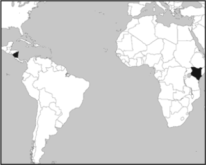
It is important that a PCCAA be undertaken in places that lend themselves well to the objectives of the research. There were three reasons for selecting Mombasa and Estelí for study. The first was an interest in smaller cities. Most of the urban population in low- and middle-income nations lives in urban centres with less than one million inhabitants, yet most studies of cities’ vulnerabilities to climate change focus on cities with more than one million inhabitants. The second reason was that these cities are “at risk” from climate change. Mombasa, a coastal city, is prone to flooding, while Estelí has experienced the impacts of flooding and drought. The third reason was the availability of appropriate committed research partner institutions with contacts with local public authorities, civil society organizations and local researchers. This ensured that recommendations from the study had the potential for implementation by municipal authorities or other local institutions.
Within each city, communities had to be chosen for the study. This involved site visits and walking with local researchers through a number of different localities to assess their suitability. It was important to ensure that communities were both poor and at risk from climate change. Housing conditions (floors, roofs and walls as well as furniture and appliances), risk from flooding and landslides, as well as tenure status and the level and standards of service provision all provided useful proxy indicators of poverty levels. Local organizations and leaders, and in some cases local municipalities, are crucial for gaining access to communities and reaching agreement about undertaking a PCCAA, and relationships must be built. Identifying research communities varies according to the context. In Mombasa, researchers established contacts with a local NGO and through it, with community-based organizations (CBOs), who helped identify local community researchers and facilities for training, and also helped with daily report-back sessions and final analysis. A more top-down process was used to identify research communities in Estelí. The mayor and his technical staff led consultations together with the Institute for Applied Research and Local Development (NITLAPAN). A combined team visited different neighbourhoods and analyzed municipal data in terms of poverty, risk, vulnerability and infrastructure levels. The team then selected four neighbourhoods as representative of those areas most at risk from severe weather.
Prior to entering a community it is useful to elicit some basic characteristics. One method is to ask counterpart organizations to construct a simple community profile with basic descriptive information, including demographic and social data such as location, geographic characteristics, a brief history, population size, number of dwellings, ethnic population and predominant household structures. Information on economic activities is also required – major income sources, access to credit, land tenure, community infrastructure, and facilities such as water, electricity, sanitation, schools and health posts. This information can be collected from such secondary sources as census data and household surveys and other studies of the community.
The four study communities selected in Mombasa were all informal settlements, three of them, Timbwani, Bofu and Tudor, established during the 1930s. The fourth settlement, Ziwa La Ngombe, was originally a settler farm with scattered housing, which became part of the municipality in 1986. Land tenure is a problem in all four settlements, although groups of landlords (including absentee owners) have land titles that are contested by current occupants.
In Estelí, three of the four settlements were formed by land invasions during the 1990s – Miguel Alonso, Belén and 29th October. The upper part of the fourth settlement, Upper Monte Sinai, is a planned neighbourhood on land donated to the municipality in 2000 by an international NGO, with housing units constructed with government subsidy. Few residents in the four settlements enjoy full title, although residents of Upper Monte Sinai have private sales documents as proof of ownership; and in Miguel Alonso, land titles have been provided gradually over the years. Belén and Upper 29th October remain without titles but are recognized by the municipality, while Lower Monte Sinai and Lower 29th October are not. Much of the housing in all four settlements is constructed of scrap materials, wooden planks and plastic and zinc sheets. In the settlements recognized by the municipality and that have some basic services, progressive improvements are ongoing. Houses in Lower Sinai and Lower 29th October are the most precarious, with temporary buildings erected on a steep slope along a natural gully and along the river bank.
c. PCCAA themes and tools
A PCCAA addresses a series of themes, each with a range of associated tools, to elicit information. Themes are derived from the background contextual discussions and analysis of the asset vulnerability, asset adaptation and climate change nexus. They include the following:
The selection of tools used depends on the context of the discussions. It is neither necessary nor possible to implement all the tools in a given group discussion, and they can be modified according to issue and context. In Kenya and Nicaragua, researchers and discussants made innovative changes to the basic sets of tools to address specific issues relating to climate change. Where relevant, these innovations are included below.
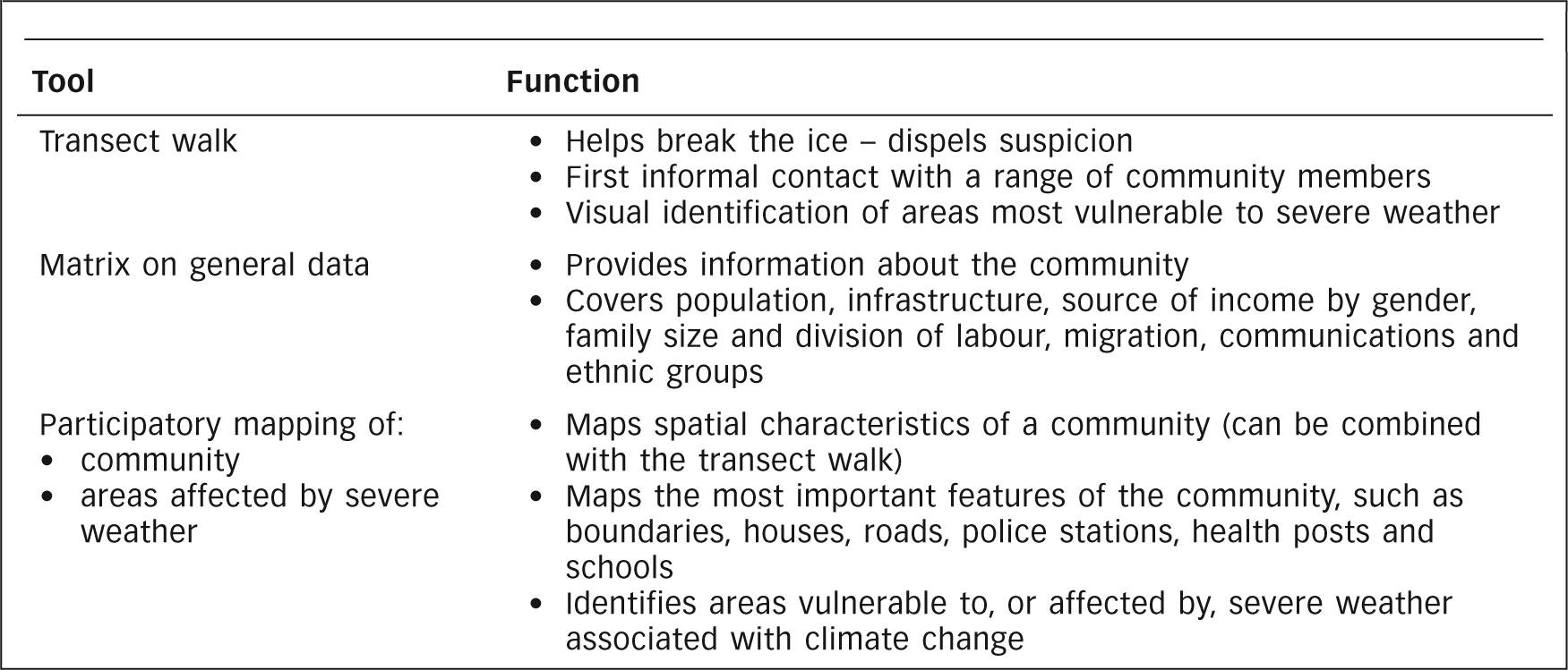
i. Community characteristics
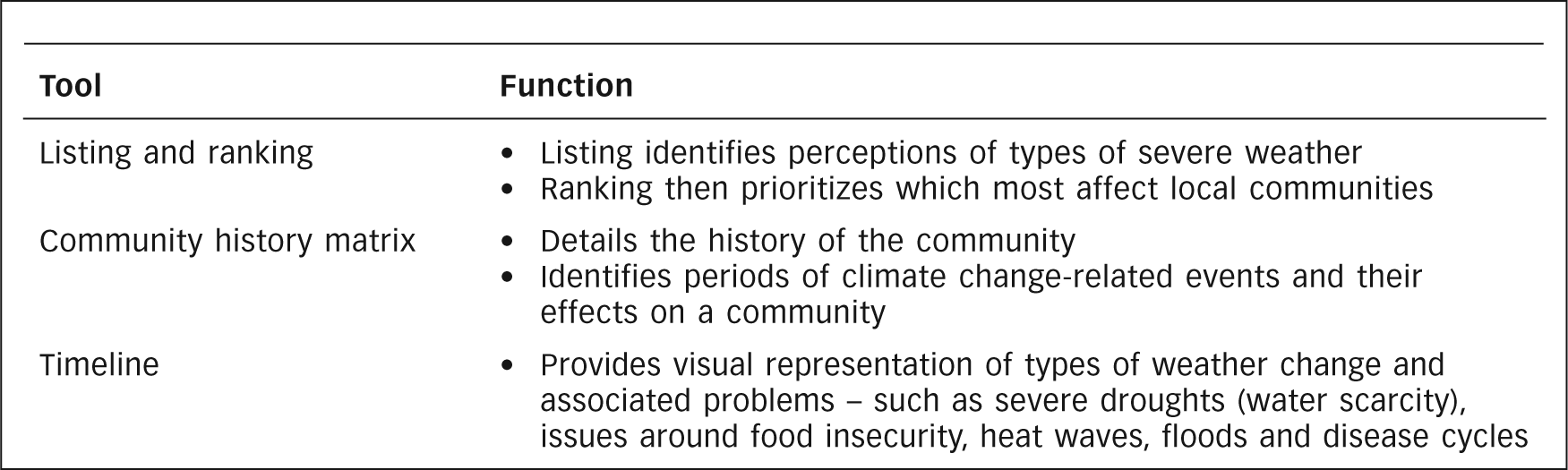
Information on community characteristics forms the foundation of a PCCAA; appropriate tools should be implemented at the beginning of the appraisal to establish the context (Box 3). In particular, the transect walk should be carried out with community leaders on initial entry into the community. This high-profile walk dispels suspicion of outsiders and informs researchers about areas that have greater vulnerability to severe weather.
Tool Box 1: Eliciting information on community characteristics
The matrix on general data (Table 1) is most usefully conducted with community leaders or people who have lived in the community for a long time. Unlike many other tools, this matrix needs to be implemented only once or twice at the beginning of the research and can be combined with the matrix on social organization. A matrix allows detailed information to be gathered quickly and systematically, and the layout ensures that information is clearly displayed.
Matrix on general data for Ziwa La Ngombe, Mombasa
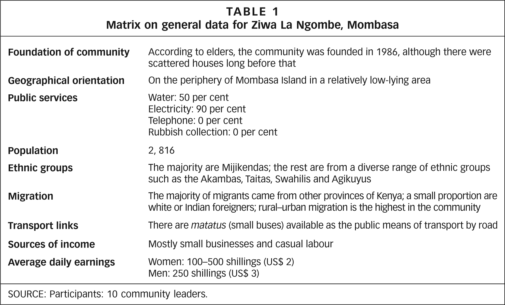
SOURCE: Participants: 10 community leaders.
Figure 1 is a map of Bofu in Mombasa drawn by several researchers, which shows both the general layout and services within the community and the location of vulnerable areas in the settlement.
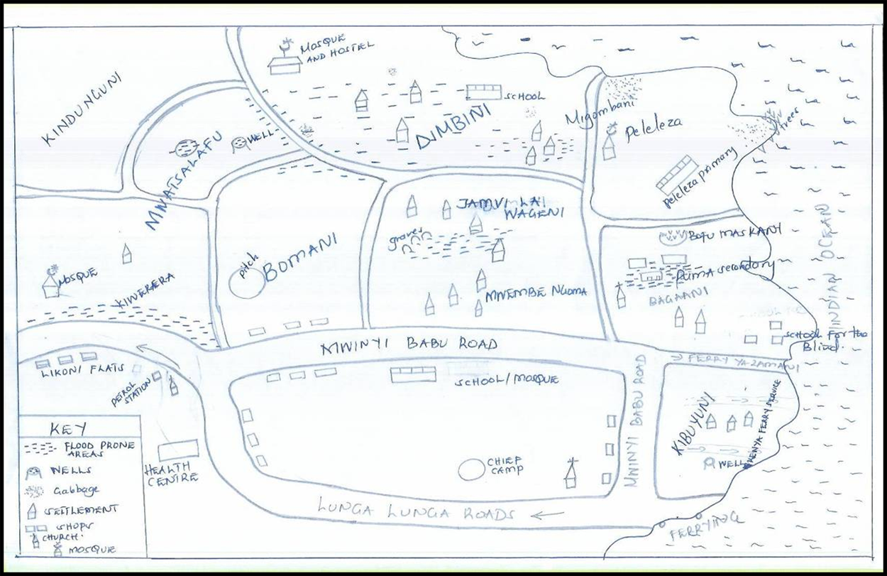
General layout and services in the community and location of the vulnerable, Bofu, Mombasa
ii. Severe weather related to climate change
The next step in the PCCAA process involves gathering information on the types of severe weather in a community, changes over time and associated general problems. Several tools can be used for this stage, as identified in Tool Box 2 (Box 4).
Tool Box 2: Gathering information on the climate in a community
Unlike other participatory urban appraisals, a PCCAA does not start with listing and ranking general problems. It starts directly with the issue of weather. Unlike well-established problems such as violence,(20) climate variability and its impacts may not be considered a priority by local communities relative to other basic needs. The usual approach could well result in extensive time being spent on listings and rankings of other problems. While interesting in themselves, they may not provide the necessary entry point to address issues of risk and vulnerability to severe weather.
The pilot stages in Mombasa indicated that local people, despite their urban location, knew about weather, perceived variations in weather patterns and had reasonable knowledge as to how it affected their assets and well-being. However, researchers discovered that they would have to avoid using the terms “disaster” and “climate change” because participants would then only recount dramatic climatic events that had occurred in the community. Instead, words such as “weather” and “seasons”, using local language and terminology, were more successful in ensuring that participants identified not only “disasters” but also other significant, slow, incremental trends in the variability and intensity of weather-related events.
Table 2 shows how a focus group in Bofu community ranked flooding as the most problematic type of severe weather. Once the simple listing and ranking of weather has been achieved, additional tools can broaden understanding of weather complexities.
Listing and ranking of severe weather events, Bofu, Mombasa
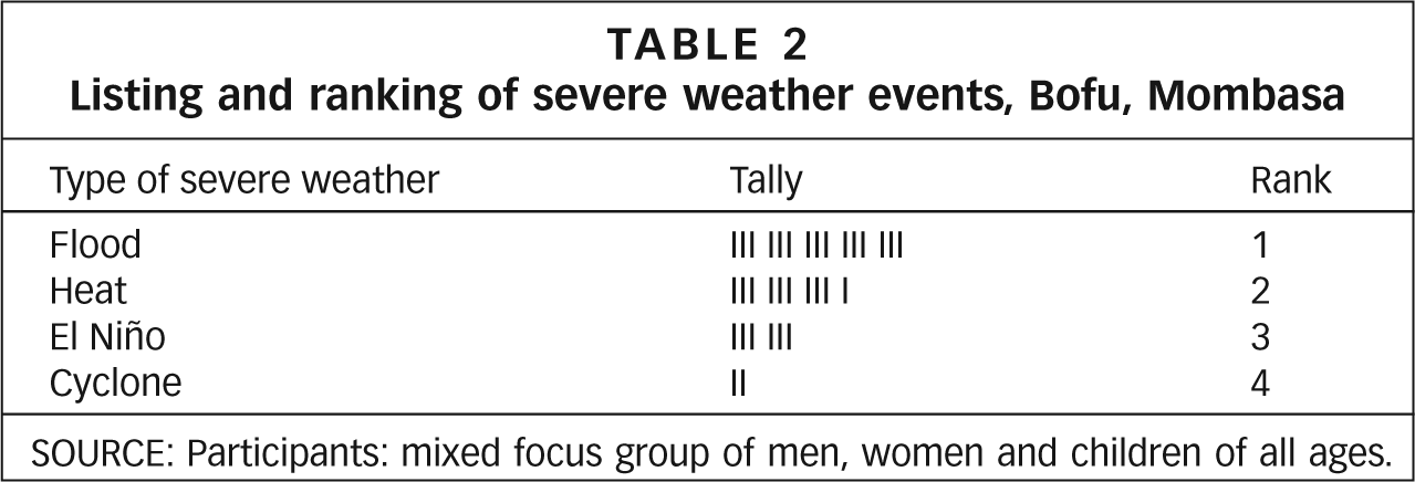
SOURCE: Participants: mixed focus group of men, women and children of all ages.
Timelines, which allow for a more specific understanding of how weather has changed over time, are best undertaken with elderly or established members familiar with the community over time. The tool may vary, depending on the time frame, which may be a day, a week, a month, a year or a range of years. Instead of initially asking participants to identify weather-related events, it is useful to begin with general events in their community. Identifying the installation of latrines, for instance, helped the Miguel Alonso residents to remember that time as a period when rainwater flooded houses in the lower parts of the community (Figure 2).
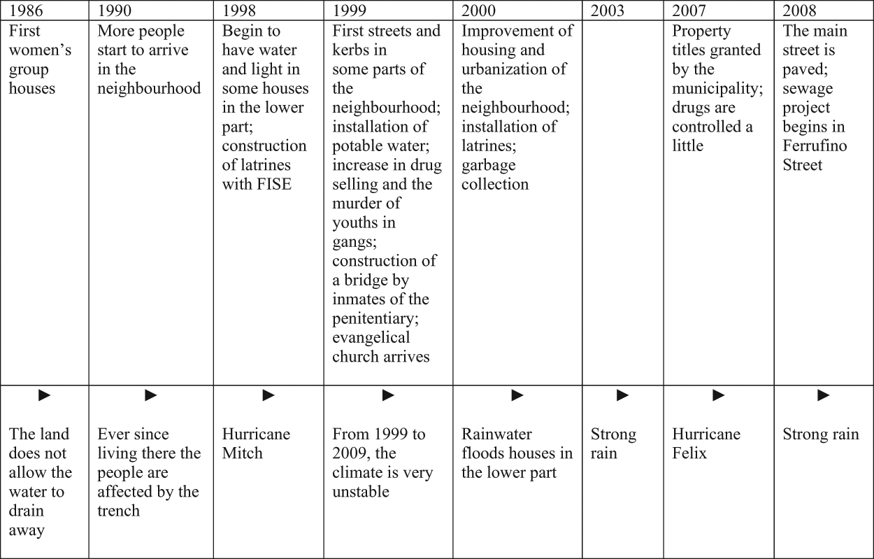
Timeline of events and severe weather in Miguel Alonso, Estelí
While timelines provide important visual tools, matrices of the history of the community can provide considerable additional information.
iii. Vulnerability to severe weather
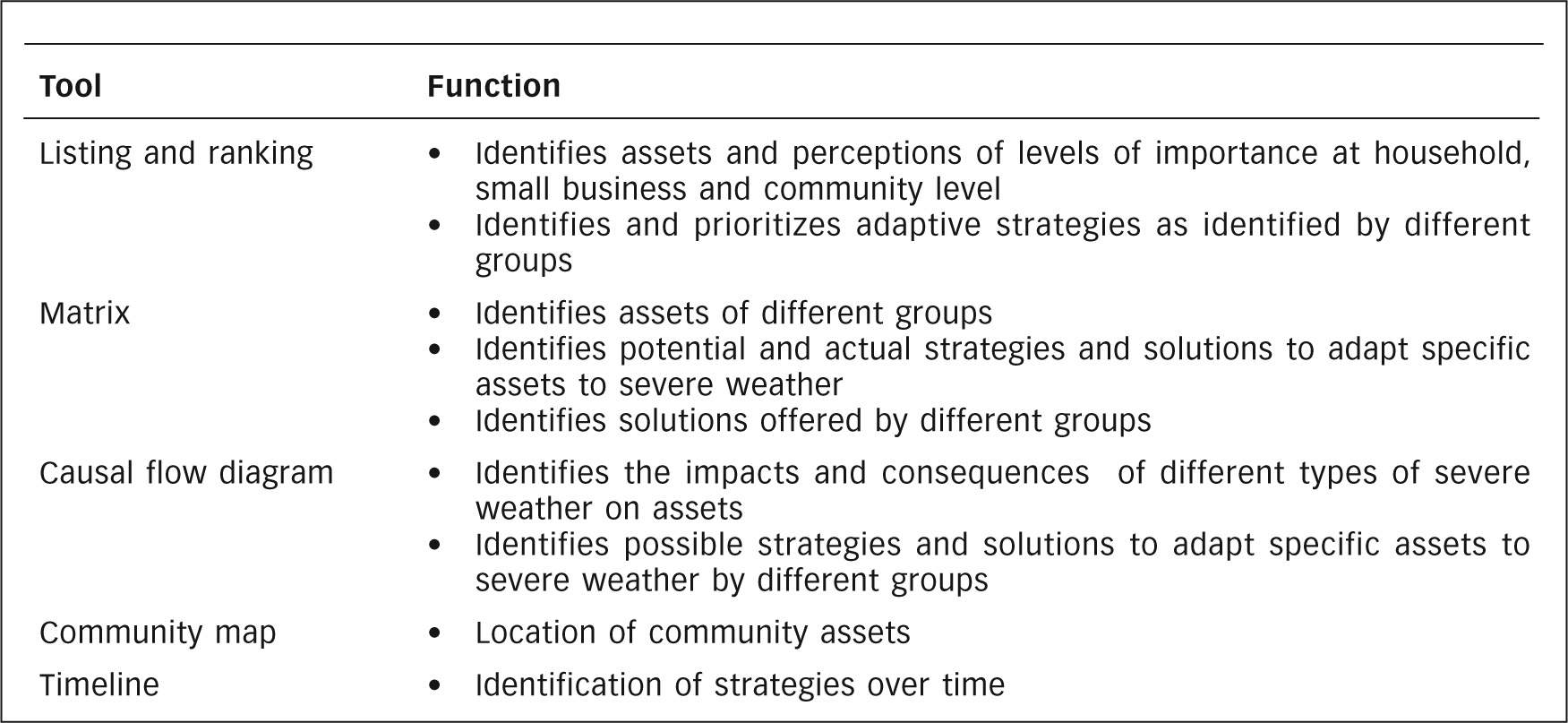
Once the types of severe weather that affect a community have been identified, the next step is to focus on the issue of vulnerability, identifying specific groups, spatial areas and assets vulnerable to severe weather. Some of the tools shown for this purpose in Tool Box 3 (Box 5), such as maps and timelines, are similar to those used to identify severe weather; others, such as causal flow diagrams, trend matrices and problem trees are more specifically focused on the types of vulnerability.
Tool Box 3: Investigating vulnerability to severe weather
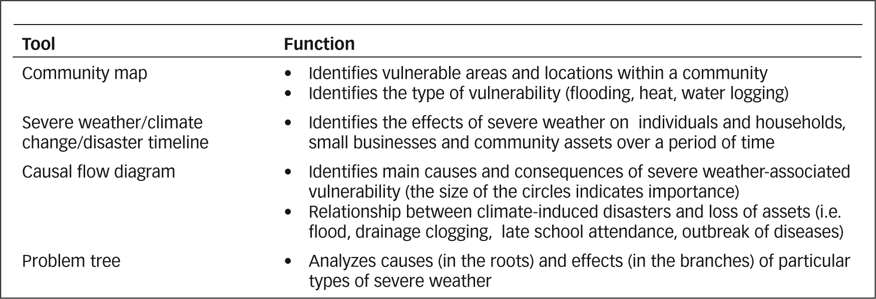
Community maps can identify spatially vulnerable areas and physical vulnerability relating to inadequate drainage, sewerage and garbage collection, but are also an entry point for identifying how the lack of legal land tenure (politico–legal vulnerability) relates to other types of household vulnerability. In Mombasa for instance, vulnerability related to insecurity had three main manifestations: location on marginal land; a lack of adequate settlement planning; and a lack of infrastructure and services.
Causal flow diagrams can be used to identify the causes and consequences of asset vulnerability and the extent to which these are linked with climate variability. In addition, they can identify the nature of networks of relationships among neighbours for lending money, providing child care and so on. This tool can also assess the relationship between severe weather and such factors as employment, education and health. In Kenya and Nicaragua, severe weather was found to erode certain assets, with negative consequences such as disease, truancy or increased mortality, depending on the context and particular asset. Figure 3 shows a causal flow diagram for Timbwani, Mombasa, which highlights the impacts of climate variability on water (a natural asset), but which also shows the variety of problems, such as dirty toilets, truancy and even death, that a lack of water can lead to.
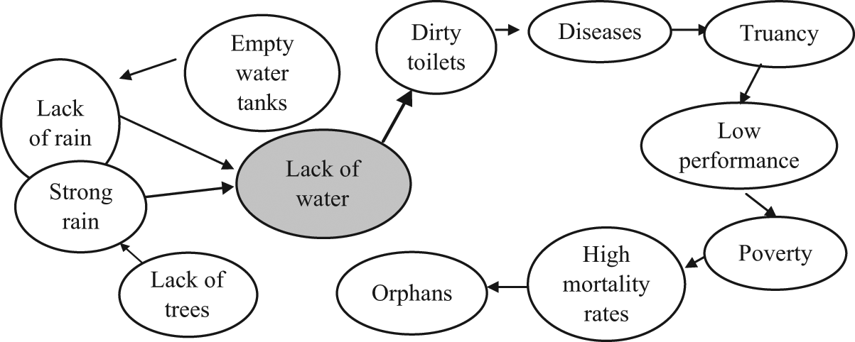
Causal flow diagram of the consequences of lack of water on school children’s health in Timbwani, Mombasa
Vulnerability is also associated with such social characteristics as age, gender, ethnicity or disability. The latter was highlighted in Mombasa, where a causal flow diagram drawn by a group of people with disabilities in Ziwa La Ngombe (Figure 4) identified how their mobility was affected by rain and flooding, and discussed ways in which this could be addressed.
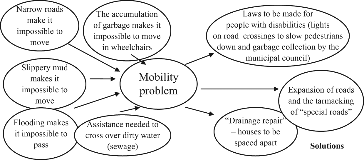
Causal flow diagram on mobility for disabled people in Ziwa la Ngombe, Mombasa
iv. Asset adaptation to severe weather
A critical component of a PCCAA relates to the identification of asset adaptation strategies at household, small business and community level, and their associated sources of resilience. This is undertaken in two stages; first, listings and rankings identify the assets considered most important by the three different groups; and second, matrices assist in elaborating strategies and potential and actual solutions to adapt assets to severe weather. Here, an important time-related distinction is made between the following:
It is important to recognize that responses may not be large scale and highly visible but, rather, small, modest, incremental activities designed to build resilience against, or respond to, increasingly recurrent patterns of severe weather.
Several tools can be useful in this stage, including listings and rankings, matrices and causal flow diagrams, with some tools being used for more than one purpose (Box 6). The first task in this stage of the PCCAA is to list and then rank assets. This identifies assets as well as the level of importance accorded to each by local residents. Table 3 shows a composite listing from all four communities in Estelí, identifying both common and distinct individual assets across communities.
Tool Box 4: Identifying assets and assets adaptation
Focus group listing of key household assets in the Estelí communities
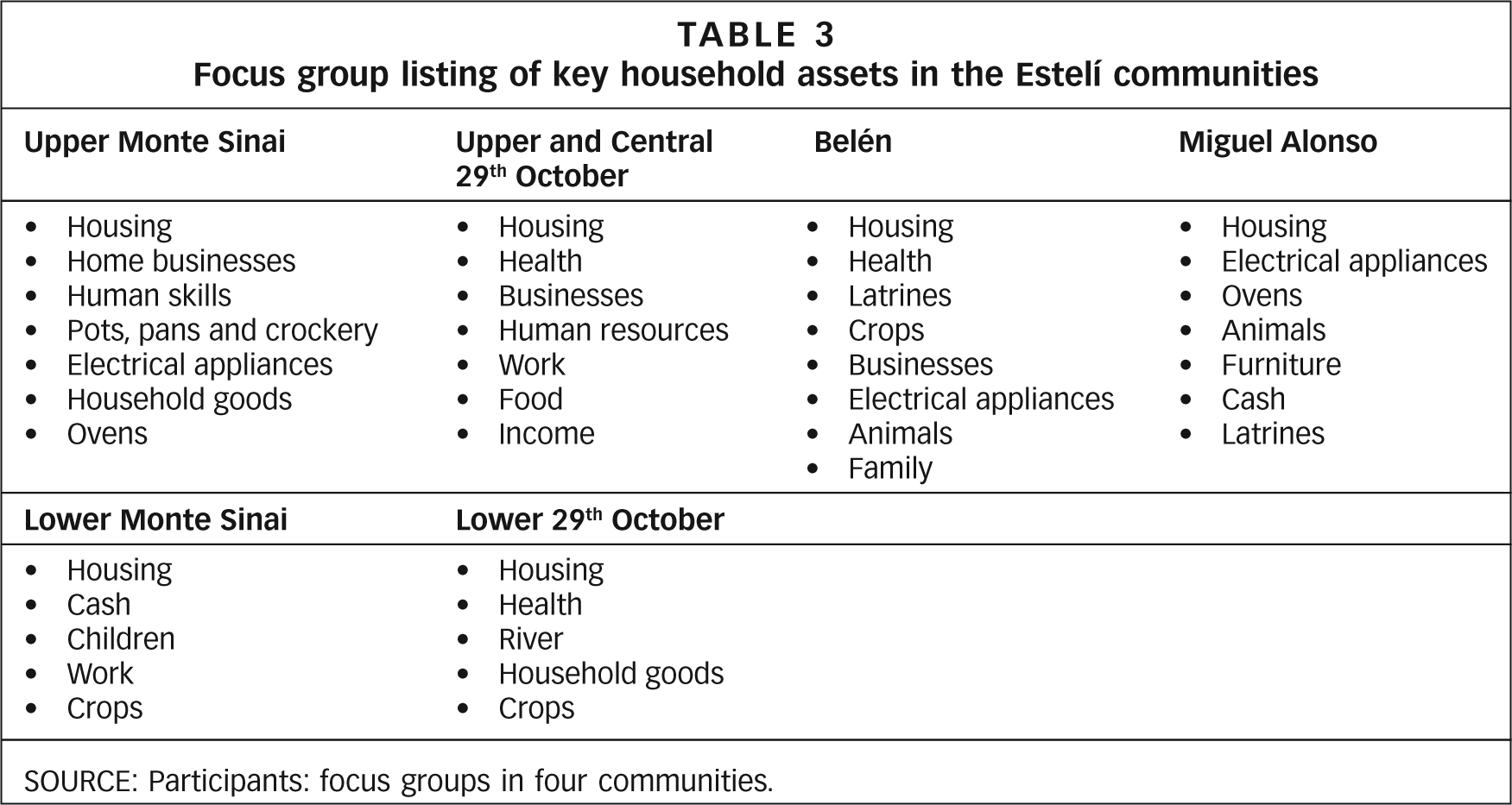
SOURCE: Participants: focus groups in four communities.
Table 4 shows the mechanics of moving from listings to rankings. Members of the Ziwa La Ngombe water project in Mombasa first listed the most important assets in the community, and then each member ranked them, giving three points to the most important, two points to the second most important and one point to the third most important asset.
Listing and ranking of community assets, Ziwa La Ngombe, Mombasa
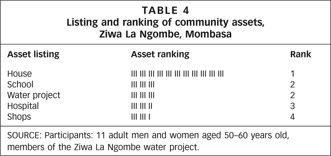
SOURCE: Participants: 11 adult men and women aged 50–60 years old, members of the Ziwa La Ngombe water project.
Such listings and rankings, undertaken with all three groups, namely households, local businesses and community groups, provide the requisite context for identifying perceptions of the most effective interventions before, during and after severe weather. As Table 5 shows, discussions on household adaptation strategies in Mombasa highlighted the different strategies of homeowners and renters.
Adaptation strategies applied by tenants and owner-occupiers during rain/floods in Mombasa
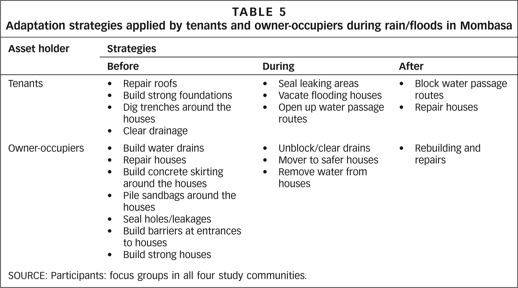
SOURCE: Participants: focus groups in all four study communities.
Finally, causal flow diagrams can be used to show causes and effects of vulnerability, as described in the previous section, but can also be an effective visual tool to identify the relationship between a weather-related problem and solutions to address it. In Figure 5, a mixed focus group from Tudor, Mombasa, discussed the relationship between the causes and solutions of the outbreak of diseases – an issue that had come up in an asset matrix.
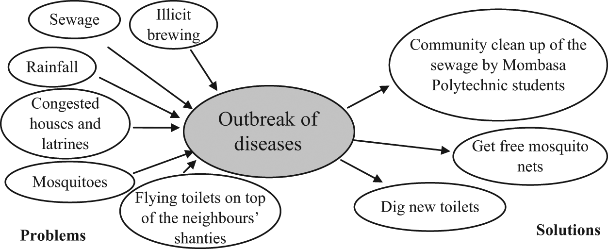
Causal flow diagram on the outbreak of diseases and possible solutions, Tudor, Mombasa
The group identified the main causes of the outbreak of diseases in their community as rainfall, sewage and congested shanties, among others. This tool also allowed them to outline both potential short-term coping strategies and longer-term solutions.
While listings and matrices provide basic information around asset adaptation, causal flow diagrams often produce the most interesting information, as illustrated by the discussion among a group of tailors who rent their space in Ziwa la Ngombe, Mombasa (Figure 6). They said that dust caused by strong winds resulted in health effects that kept them from working, and also caused sewing machines to malfunction when sand got inside them. They distinguished between their own modest efforts to clean their sewing machines and the more permanent solutions that landlords could potentially provide, such as introducing glass doors.
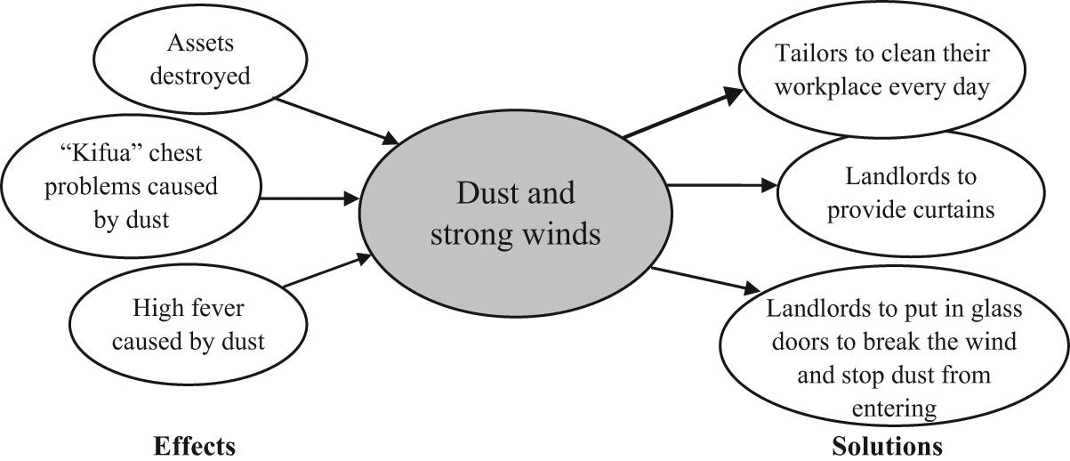
Effects of and solutions to dust and strong winds in Ziwa la Ngombe, Mombasa
v. Institutions supporting local adaptation
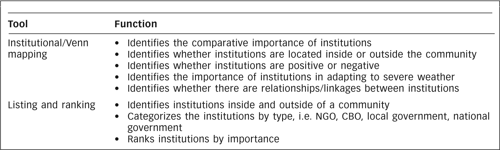
The final stage in a PCCAA is the identification of local institutions in terms of their importance and support to local communities when these are experiencing severe weather; this is also a two-phase process. First, focus groups identify institutions perceived as being important locally, from informal associations to formal state and religious institutions. Institutional (or Venn) mapping is an important tool in identifying three aspects of these institutions:
spatial location (inside or outside the community);
relative importance – indicated by the size of the circle – in terms of their role in the community; and
whether they are perceived as positive or negative – in terms of their contribution to community development.
Second, focus groups identify those institutions that particularly assist local communities in building resilience or in responding to severe weather. This allows them to recognize that they are not always the same institutions as those identified in the first institutional mapping exercise. Listing and ranking tools help prioritize the most important, while matrices can be used to identify institutional strategies and solutions. The different tools are identified in Tool Box 5 (Box 7).
Tool Box 5: Identifying the importance of institutions supporting local adaptation
Institutional mapping in Estelí showed that in all four communities, key individuals, within and outside the neighbourhood, were perceived as important agents in community coping strategies. These were individuals valued for their knowledge, contacts and capacity to solve problems, especially in emergencies. In 29th October, for example, four individuals were ranked higher than some institutions (Figure 7). This map highlights the different relationships among public institutions, NGOs and community-based organizations during and after severe weather events.
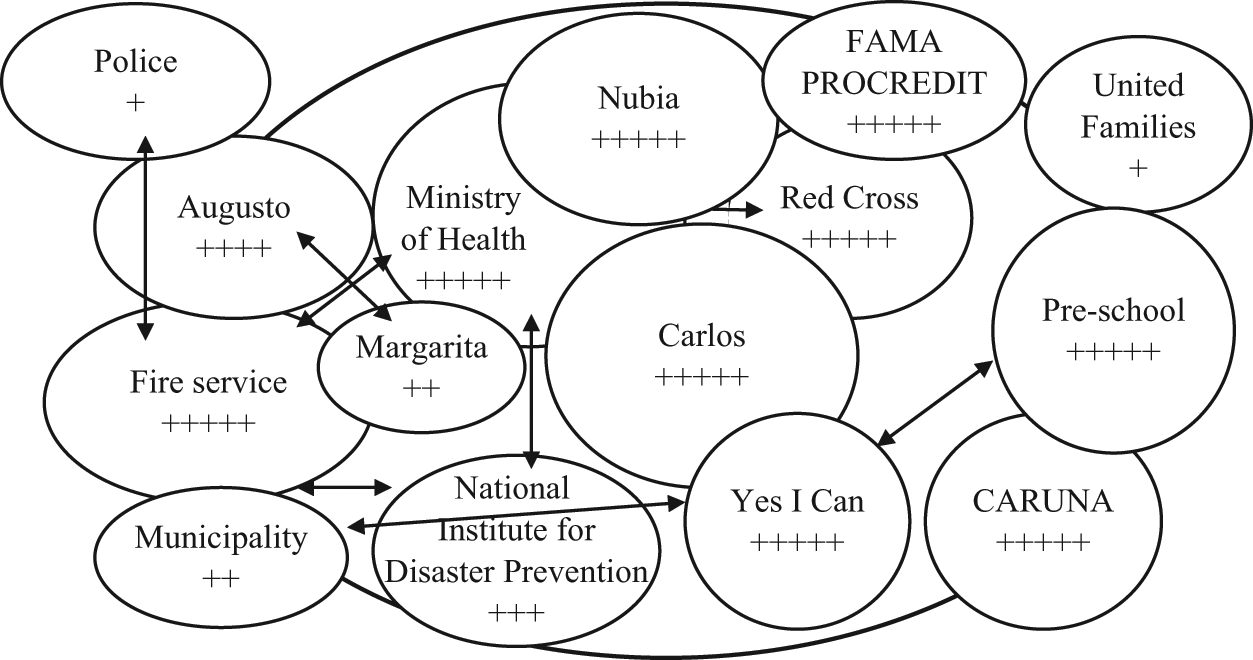
Mapping of important institutions in adapting to weather in 29th October, Estelí
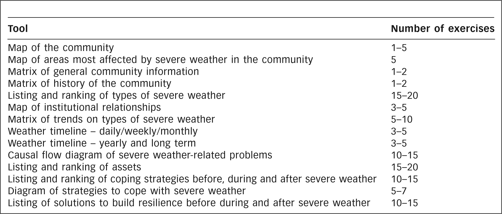
vi. Summary of PCCAA tools
While there are no set rules on the number of tools that should be used when conducting a PCCAA, Tool Box 6 (Box 8) lists the basic tools and the recommended number of exercises to be applied during a PCCAA, such as those that took place in Kenya and Nicaragua. The list serves only as a guideline; other tools can be implemented, depending on the context.
Tool Box 6: Summary of main tools for a PCCAA and recommended number of exercises
IV. Analysis of Pccaa: The Issue of Quantification
The analysis of PCCAA data is as important as its collection. The “generic” methodology described in sub-section III(a) above allocates the final, fifth week to local researchers’ initial analysis and the completion of preliminary results. These are presented to stakeholders inside and outside the community at the end of this final week. More complex analysis can take considerably longer depending on the depth required. Analysis moves from the recorded perceptions of individual focus groups to broader results based on both qualitative and quantitative data – with the latter being particularly useful for sending important messages to those policy makers who dismiss participatory research as anecdotal.
As is the case with all participatory research, it is the focus group reports (FGRs), written at the end of each day (or the following morning), that are the primary data source. Unlike questionnaire surveys, statistical packages for data analysis do not exist; researchers work “manually” from the FGRs, often making multiple photocopies so that team members can divide up the work. The first stage of analysis is a brainstorming session by all researchers to record their initial impressions, based on the FGRs, followed by the development of a thematic structure within which to analyze the results. With appropriate modification, this frequently follows the same analytical framework identified at the outset of the research (see above).
The final report of the PCCAA is likely to include the following components:
community perceptions of change/increases in severe weather;
asset vulnerability to severe weather:
including physical, legal and socioeconomic vulnerability; identifying social groups that are particularly affected;
asset-based adaptation strategies to build long-term resilience, for damage limitation and protection during severe weather and for rebuilding after severe weather:
household, small business and collective (community level) adaptation;
the role of local institutions in adaptation to weather changes:
government, religious, externally supported NGOs, internal CBOs, inter-institutional collaboration; and
conclusions and recommendations.
The resulting work plan allows researchers to divide the analysis into different sections, with smaller groups using all the FGRs to analyze the relevant issue. Research teams undertaking the PCCAA in Mombasa and Estelí each completed their own reports; because an identical methodology and associated tools were used in both cities, a cross-city comparative report was completed subsequently, and the following illustrations of data analysis are drawn from this document.
a. Examples of PCCAA data analysis
i. Community perceptions of changes in weather: quantification of listings and rankings
The quantification of listing and ranking matrices from all focus groups was very useful in providing data that showed similarities in perceptions of severe weather in both cities (Table 6); rain and associated flooding was identified as the most severe problem in both Mombasa (49.8 per cent) and Estelí (69.8 per cent).
Composite matrix of perceptions of the most significant weather hazards in Mombasa and Estelí
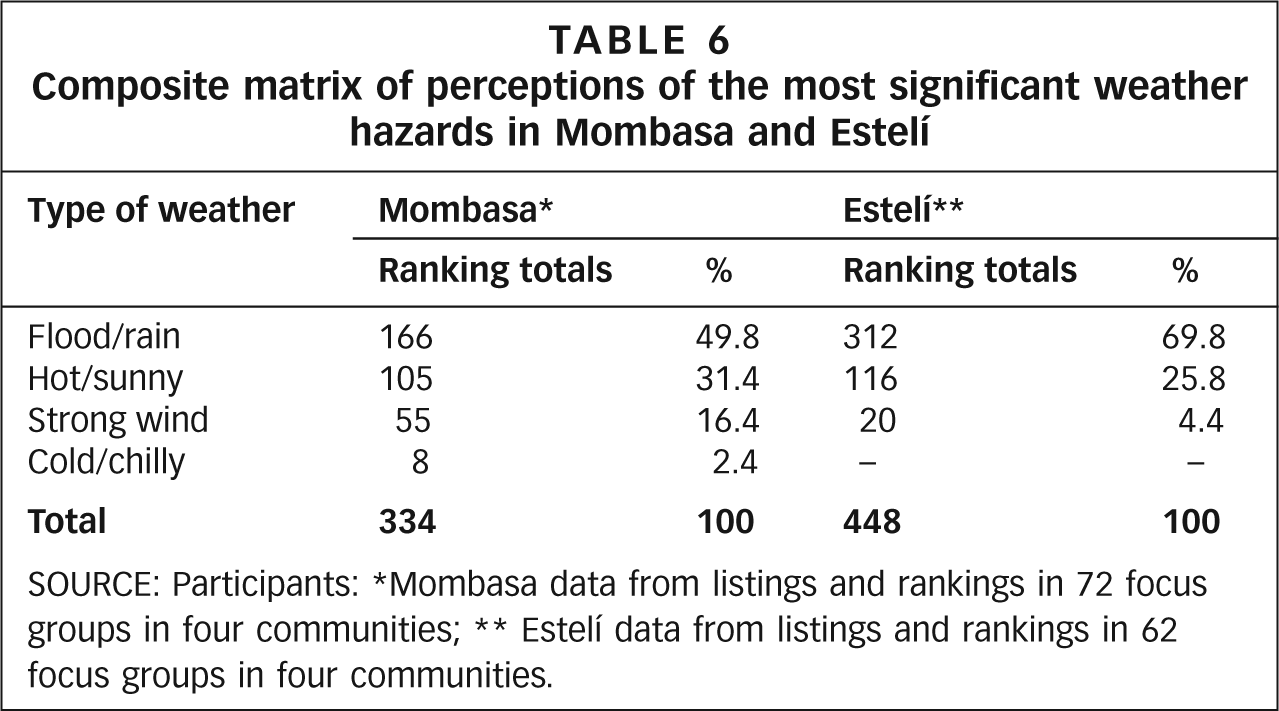
SOURCE: Participants: *Mombasa data from listings and rankings in 72 focus groups in four communities; ** Estelí data from listings and rankings in 62 focus groups in four communities.
ii. Asset vulnerability to severe weather
Participatory tools such as transect walks, community maps, matrices and causal flow diagrams, as well as comments from focus group members, together assisted in the identification of complex physical, legal and socioeconomic vulnerabilities experienced by households and communities in the face of severe weather. Politico–legal vulnerability resulting from lack of tenure involved three inter-related factors, namely location on marginal land, lack of municipal infrastructure provision and reluctance to invest in improved housing. This demonstrated the importance of triangulation of the different qualitative tools.
iii. Asset adaptations before, during and after severe weather: quantification of listings
Further quantification comes from the listed actions in asset adaptation matrices. As shown in Table 7, in Mombasa the majority (89 per cent) of households, small businesses and community groups adopted a range of resilience measures, with households more likely to respond than other groups (94 per cent), particularly during severe weather. Such quantification is useful to highlight the fact that local communities are not passive in the face of weather changes, but proactively respond to the changing weather. At the same time, on its own such data can be misleading if it is not complemented by qualitative data that describes the variation in adaptation measures. While some may involve fundamental structural (re)building, others may be minor adjustments, such as moving household goods to safer locations.
Focus group matrices identifying asset actions before, during and after severe weather at household, small business and community levels in Mombasa, Kenya
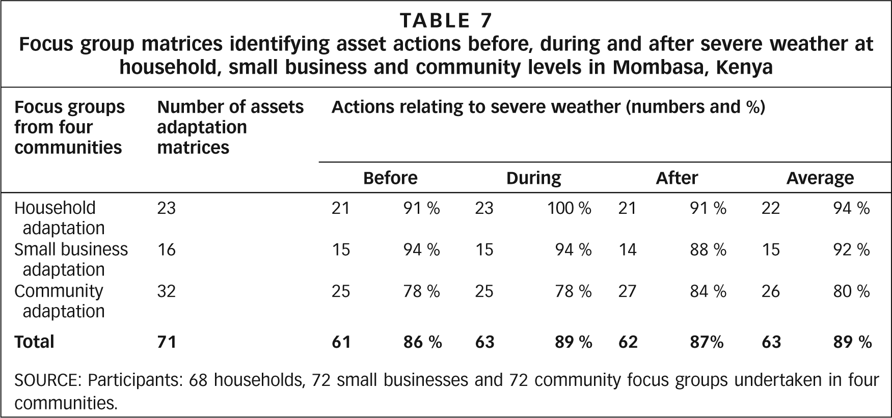
SOURCE: Participants: 68 households, 72 small businesses and 72 community focus groups undertaken in four communities.
b. Institutional maps
Finally, institutional maps provide a wealth of data, both individually as well as comparatively. Interpreting such maps through a quantification of the total circles drawn helps comparative identification of their relative importance in the community, while complementary matrices of those responding to severe weather show that they are often not the most important institutions. Again, qualitative data relating to the size of circles and their identification as positive or negative institutions generates a far richer picture of institutional responses.
V. Concluding Comments
The PCCAA in Mombasa and Estelí provided a better understanding of the asset vulnerability of the urban poor to severe weather. This included the physical, politico–legal and socioeconomic vulnerabilities they faced (the state of water, sanitation and drainage infrastructure, and garbage collection, as well as the legal vulnerability in contexts of precarious land tenancy rights). As important, the PCCAA helped identify the different asset adaptation strategies that urban poor households, small businesses and communities adopt in order to face the impacts of severe weather. The PCCAA is a useful tool for local authorities, NGOs and researchers alike in identifying and recognizing these strategies. Consequently, the PCCAA can become an important tool in the dialogue between communities and local authorities concerning the most appropriate interventions that will best assist them to build long-term resilience in the face of changes in weather conditions associated with climate change.
The limited number of PCCAAs means that, to date, researchers conducting such appraisals have had little experience on which to draw. While recognizing that participatory appraisals are inherently flexible and should be guided by the people in the research communities, this paper provides some basic guidelines and a starting point for designing research and a way of systematizing analysis. It also shows that some participatory urban appraisal tools are more suitable for exploring climate change-related issues than others. Thus, while the guidelines are only based on a potential range of tools, it is hoped that they will help researchers seeking to undertake research in this area.
Footnotes
An earlier version of this paper was published as Global Urban Research Centre Working Paper No 5. It draws on research commissioned by the World Bank Social Development Department undertaken in collaboration with research institutions in Kenya and Nicaragua. We would like to acknowledge the collaboration of Andrew Norton and Sophia Georgieva at the World Bank; Alfred Omenya, Grace Lubaale and Titus Wamae from Eco Build Africa and their research team in Mombasa; Ligia Gómez, Gema Lorio, Yuri Marín and Francisco Pérez from the Institute for Applied Research and Local Development (NITLAPAN) at the Central American University; the research team from the Multiple Discipline Regional Faculty (FAREM) in Estelí; and Irene Vance, an independent researcher.
1
Moser, C and J Holland (1997), “Urban poverty and violence in Jamaica”, World Bank Latin American and Caribbean Studies: Viewpoints, World Bank, Washington DC, 50 pages; also Moser, C and C McIlwaine (1999), “Participatory urban appraisal and its application for research on violence”, Environment and Urbanization Vol 11, No 2, October, pages 203–226; and Moser, C and C McIlwaine (2004), “Drugs, alcohol and community tolerance: an urban ethnography from Colombia and Guatemala”, Environment and Urbanization Vol 16, No 2, October, pages 49–62.
2
Moser, C, A Acosta and M E Vasquez (2006), Mujeres y Paz: Construcción de Consensos, Guía para Procesos Participativos e Incluyentes, Social Policy International, Bogotá, 110 pages.
3
This working paper draws heavily on the empirical data from Moser, C, A Norton, A Stein and S Georgieva (2010), Pro-poor Adaptation to Climate Change in Urban Centres: Case Studies of Vulnerability and Resilience in Kenya and Nicaragua,” World Bank Report No 54947, Washington DC, 84 pages.
4
Moser, C and D Satterthwaite (2008), Towards Pro-poor Adaptation to Climate Change in the Urban Centres of Low-and Middle-income Countries,” Human Settlements Discussion Paper Series, Climate Change and Cities 3, IIED, London, 50 pages; also Moser, C (2009), Ordinary Families, Extraordinary Lives: Assets and Poverty Reduction in Guayaquil 1978–2004, Brookings Institution Press, Washington DC, 360 pages.
5
McGranahan, G, D Balk and B Anderson (2007), “The rising tide: assessing the risks of climate change and human settlements in low elevation coastal zones”, Environment and Urbanization Vol 19, No 1, April, pages 17–37.
6
8
As Robert Chambers stated, participatory methodology is “…a growing field of approaches and methods to enable local (rural and urban) people to express, enhance, share and analyze their knowledge of life and conditions to plan and act.” See Chambers, R (1994), “The origins and practice of participatory rural appraisal”, World Development Vol 22, page 953.
9
See, for instance, Brock, K and R McGee (editors) (2002), Knowing Poverty: Critical Reflections on Participatory Research and Policy, Earthscan, London, 224 pages; also Kanbur, R (2003), “Q-squared? A commentary on qualitative and quantitative poverty appraisal”, in R Kanbur (editor), Q-squared: Qualitative and Quantitative Poverty Appraisal, Permanent Black, Delhi, pages 1–16; and Holland, J and J Campbell (2005), Methods in Development Research: Combining Qualitative and Quantitative Approaches, ITDG, Warwickshire, 256 pages.
10
12
Grootaert, C and T van Bastaelaer (editors) (2002), Understanding and Measuring Social Capital: A Multidisciplinary Tool for Practitioners, World Bank, Washington DC, 320 pages.
13
Appadurai, A (2004), “The capacity to aspire: culture and the terms of recognition”, in V Rao and M Walton, Culture and Public Action, Stanford University Press, California, pages 59–84.
14
Alsop, R, M F Bertelsen and J Holland (2006), Empowerment in Practice: From Analysis to Implementation, World Bank, Washington DC, 386 pages.
15
Moser, C (editor) (2007), Reducing Global Poverty: The Case for Asset Accumulation, Brookings Institution Press, Washington DC, 305 pages; also Ferguson, C, C Moser and A Norton (2007), “Claiming rights: citizenship and the politics of asset distribution”, in C Moser (editor), Reducing Global Poverty: the Case for Asset Accumulation, Brookings Institution Press, Washington DC, pages 273–288.
16
Ginieniewicz, J (2009), The Accumulation and Transfer of Civic and Political Assets by Argentinian Migrants to Spain: a Theoretical and Empirical Review”, Global Urban Research Centre Working Paper No 2, the University of Manchester, UK, 29 pages.
17
Moser, C and D Satterthwaite (2010), “Toward pro-poor adaptation to climate change in the urban centres of low- and middle-income countries”, in R Mearns and A Norton (editors), Social Dimensions of Climate Change: Equity and Vulnerability in a Warming World, World Bank, Washington DC, pages 231–258.
18
See reference 8, Chambers (1994); also Norton, A (1998), “Analyzing participatory research for policy change”, in J Holland and J Blackburn (editors), Whose Voice? Participatory Research and Policy Change, Intermediate Technology Publications, London, 208 pages; and Shah, M (1995), Training Workshop on Participatory Appraisal Methods for Participatory Assessment of Urban Poverty and Violence in Jamaica, September 12–22, World Bank, Washington DC, 30 pages.