
Abstract
This review focuses on recent research literature on the use of Semantic Web Technologies (SWT) in city planning. The review foregrounds representational, evaluative, projective, and synthetical meta-practices as constituent practices of city planning. We structure our review around these four meta-practices that we consider fundamental to those processes. We find that significant research exists in all four metapractices. Linking across domains by combining various methods of semantic knowledge generation, processing, and management is necessary to bridge gaps between these meta-practices and will enable future Semantic City Planning Systems.
Keywords
Introduction
Rapid urbanisation has resulted in the unprecedented growth in the size and number of cities world-wide (UN 2018). Urbanisation has produced a sharp rise in consumption of energy, land and metals and other raw materials. This, in turn, has increased green-house gas emissions that contribute to climate change (Swilling et al. 2018). Planning and managing the growth of cities today and into the future is widely regarded as essential if we are to address the challenge of climate change and the host of associated issues that underpin long-term livability and sustainability (Shukla et al. 2019).
Modern city planning emerged in nineteenth-century England, continental Europe and the United States alongside urbanisation and industrialisation. This modern city planning took shape as a response to new societal challenges triggered by those processes such as managing pollution, sanitation and public health, providing affordable housing for growing populations, integrating new utilities like gas and electricity, and delivering efficient urban transportation (Hein 2017b, 2). Planning developed hand-in-hand with new social scientific, statistical and cartographic techniques needed to empirically record the various social, economic and physical aspects of rapidly growing cities (Seto, Solecki and Griffith 2016; Habitat 2017; Hein 2017a).
The discipline also diversified in response to changing political and social mores in the twentieth century. This saw an increasing multisectoral outlook, with greater involvement of private sector interests and civil society through participatory planning movements. At the same time, a growing interdisciplinarity in planning was accompanied by a tendency towards fragmentation into various sub-disciplinary socioeconomic, environmental and physical design-oriented traditions (Oliveira and Pinho 2010; Gleye 2015; Hein 2017a). These demands, which focus directly on the empirical traditions of the discipline, concern improving the credibility, timeliness and diversity of evidence to support the planning of sustainable cities. Harnessing the rise of information communication technology (ICT), big data and artificial intelligence (AI) has been regarded as imperative to meet these demands (Townsend 2013; Trindade et al. 2017)).
City Planning (CP) has been integrating the growing availability of digital data. The rise of Geographic Information Systems (GIS) and various digital planning support tools e-governance and entrepreneurial governance systems have become central the discipline (Batty 2013; Burger, van Oort and Meijers 2019; Stead 2021). Despite these recent advances, Batty (2017) and Helbing and Pournaras (2015) note that CP has yet to effectively harness the full possibilities of the ICT revolution. The exponential growth in quantity of data on cities and city processes, has been supported by improved capacities to store and manage those data and make them available to city-making stakeholders across the board. Even if these kinds of data are digitised and made available on websites, they remain relatively static and difficult to cross-reference and analyse (Laurian and Inch 2019). The many new digital tools that have emerged lack, as Dominic Stead puts it, a ‘framework for categorizing, analyzing, and comparing’ them (Stead 2021). Providing such a framework would rely on developing ‘a better system of validation and critical assimilation of scientific knowledge’ into city planning (Marshall 2012b, 267).
There are many possible reasons for the relative hesitancy of city planning to harness digital data. They may concern the way the discipline itself has tended to prioritise the craft of planning rather than tending to its scientific foundations (Marshall 2012b). They may also concern the relatively rigid sectoral disposition of the discipline in the face of the rising complexity of cities and growing interdependency of their social, political, ecological and material dimensions (Hein 2017a). This difficulty is underscored when considered in different contemporary geographical settings around the world where the processes of globalization are unfolding in such diverse ways (see Parnell (2020); Kusno (2020); and Abramson (2020) in context of Africa, China and Southeast Asia respectively). They may also concern the data themselves. Although more numerous, big data are typically sourced in many different formats, are stored in distinctive siloes, and managed in inconsistent ways.
This review focuses on the last of these possible reasons. It does so by focusing on recent developments in the field of Semantic Web Technology (SWT). SWT is an area of innovation in the digital revolution that offers a promising approach to solving the difficulties with data fragmentation and supporting the more effective use of big data in planning. SWT is promising in this context because it focuses on structuring and linking data, making it more searchable and accessible.
For the purposes of this review, we define CP in section 3.1 as a complex task that re- quires four Meta-Practices (MP) that occur simultaneously during CP processes: Representational MP, Evaluative MP, Projective MP, and Synthetical MP. Our purpose is to better support planning practice, and its ability to address the challenges of urbanisation, demographic shift and climate change with Semantic City Planning Systems (SCPS) at the intersection of CP and SWT - see figure 1.
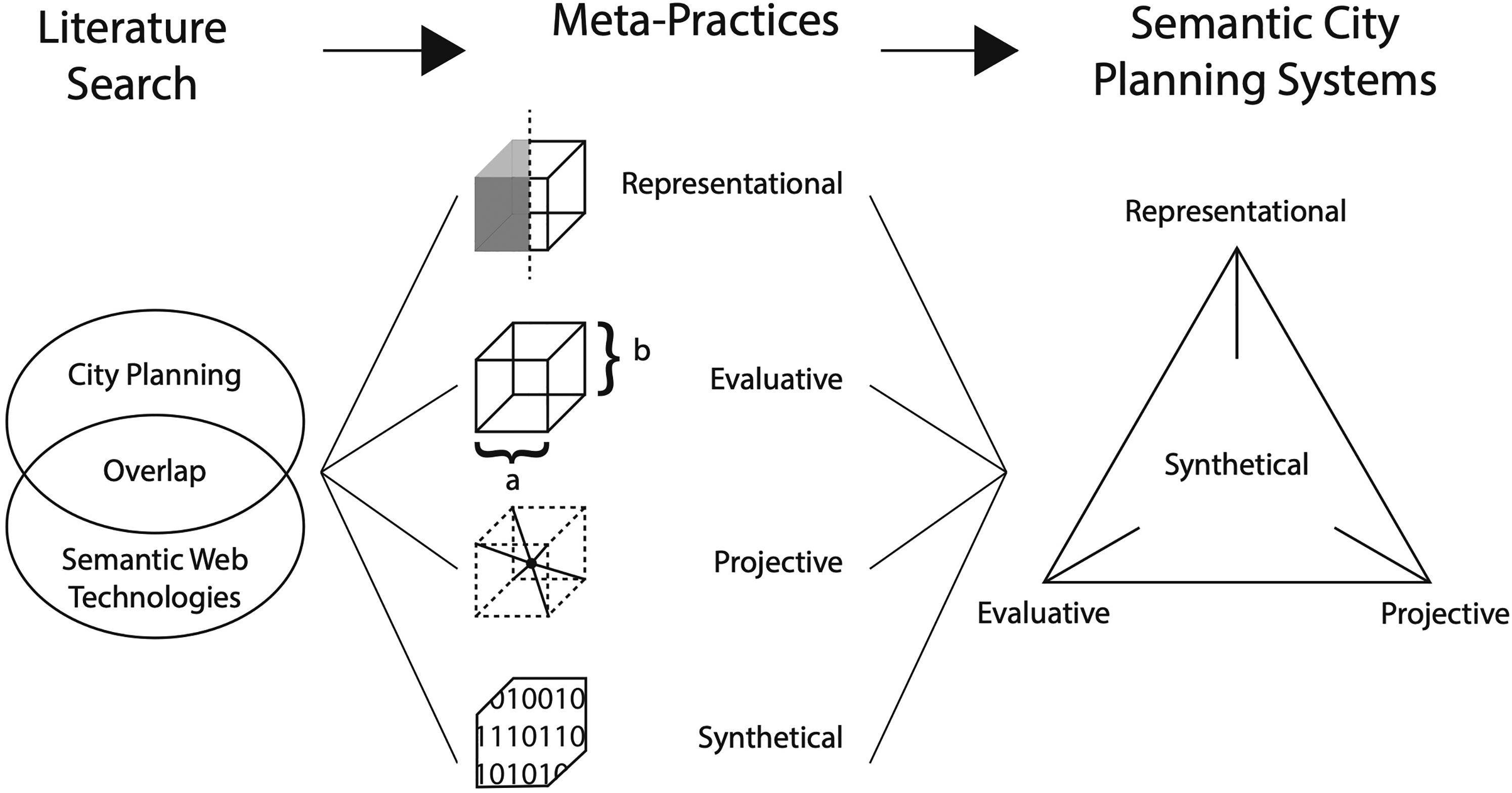
SCPS diagram.
In section 2 we provide a short overview of digital urban planning and describe how SWT present opportunities for CP and how planning-related knowledge is represented in this context. We explain and define SCPS as a necessary endeavor for future CP in section 3. We arrange the found literature and uncover research gaps that we present in section 4. We structure our findings along four MP with section 4.1 on Representational MP, section 4.2 on Evaluative MP, section 4.3 on Projective MP, and section 4.4 on Synthetical MP. We discuss and unify the found research niches under SCPS in section 5.
This background section situates three main domains that form the foundation of SCPS: SWT in subsection 2.1 and their potential for CP, concepts of knowledge representation of planning and design processes in subsection 2.2, and an overview of the diverse state of the art of digital urban planning in subsection 2.3.
Semantic Web Technologies (SWT)
SWT are built on the concepts of linked data and semantic web. Linked data is data that is structured and interlinked with other data. The semantic web aims to make data on the web machine-readable and interpretable (Bizer, Heath and Berners-Lee 2009; Semantic Web 2015). Semantics relate to the study of meaning, reference, or ‘truth’ (Hale and Wright 1999) and can be formulated mathematically based in descriptive logic. The se- mantic web builds on the availability, accessibility of, and the relationship among, data (Semantic Web 2015). SWT are already transforming the Architectural, Engineering, and Construction (AEC) industries (Pauwels, Zhang and Lee 2017). SWT enable the representation of complex systems and can facilitate to represent everything of interest (i.e. cities and their components).
The following terms are crucial in understanding SWT and their potential for CP:
Knowledge Representation and Semantics By virtue of representing data and the relationship among them, based in descriptive logic, SWT enable more integrated knowledge representation. Semantics can be used to infer information from linked data and allow to set axioms or principles that define knowledge in specific domains. Naturally, many SWT concepts and approaches are fundamental to the discipline of Artificial Intelligence - particularly its field of Knowledge Representation and Reasoning (Levesque 1986). Applied Ontology / Knowledge Domains Applied Ontology, also referred to as Computational Ontology, implies the application of ontological approaches (from the philosophical branch of Ontology) to specific knowledge domains, and is commonly practised in Information Science and Computer Science (Guarino 1995). An ontology represents a common vocabulary that is necessary for data and relationships among them to be understandable, meaningful and replicable. Web Ontology Language (OWL) is commonly used as knowledge representation language (schema) of the semantic web. Once a knowledge domain is identified, one can design, define, and compose ontologies for many different applications and purposes. (Semantic) Triples / RDF / Graph Databases Information in the semantic web is stored in triples of ‘subject, predicate, object’ to describe the data and the relationship among them. Each triple can thus link to others, forming a web. Resource Description Framework (RDF) is the data modeling framework for the Semantic Web. For semantic CP, it is thus crucial to represent urban data (geo-location, 3D geometry, textures, attributes, dynamic data, etcetera) as RDF files. Protocol and RDF Query Language (SPARQL) is a query language for semantic webs designed to query data across systems and data-bases. Knowledge Graph If data is represented as a node, and the semantic relation, guided by the common vocabulary or ontology, as their edge, then semantic webs can be represented as mathematical graphs of semantic triples. Knowledge Graphs (KG) represents the full integration of data and web structure of a semantic system. For CP this promises to overcome the fundamental challenges associated with current digital planning of ‘siloed’ expertise; fragmented, incomplete and inaccessible data; ill definition and large scale of problems (Pan et al. 2015). KG can for example enable a multi-scalar and multi-domain simulation (Pan et al. 2016; Eibeck, Lim and Kraft 2019) and the instantiation of Parallel Worlds (PW) scenarios (Eibeck et al. 2020). Dynamic Knowledge Graph / agent systems in KG Dynamic Knowledge Graphs (DKG) are systems that can reconfigure the graph structure dynamically, in response to changing context, to new queries, or to their own increased knowledge, by way of multi agent systems embedded into the KG structure. Examples include industrial process engineering and chemistry processes represented with Artificial Intelligence (AI) composition agents to reconfigure the KG as needed (Zhou et al. 2019; Farazi et al. 2020).
Methods for Design Synthesis
Marshall (2012a, 192) argues to recognise “the positive benefits of a complex system of planning, capable of generating functional urban complexity”. CP is inherently interdisciplinary with implications on design (Marshall, Gong and Green 2019). The adage that planning deals with the basic question ‘How much of what goes where, and why?’ (Herthogs 2016, 25). CP necessarily works towards multiple objectives, establishing satisfactory syntheses that integrate information from multiple knowledge domains. Urban designers and planners have developed a wide range of strategies to design and manage urban projects of which we will list some attempts that explicate design processes using computational methods.
Design Heuristics In practice, designing and planning are routed in heuristic approaches and tacit knowledge formation that designers and planners acquire in their education and by experience. These increase the domain knowledge and expand the solution space for a design problem (Lösch, Dugdale and Demazeau 2009). Designers move from abstract idea elaboration and opportunity-seeking ‘design freedom’ to gradually more concrete solutions and reduction through decision-making ‘design solutions’ (Lösch, Dugdale and Demazeau 2009). Such knowledge based in human creativity is hard to systematise and replicate with computers. Hence, the aim of so-called ‘computational design’ is to enhance the work of designer with digital methods and tools. Urban Elements First attempts to synthesise urban phenomena in ‘pattern languages’ and to collect them in thesaurus-like manner were made by Alexander (1964) and Alexander, Ishikawa and Silverstein (1977). Alexander's concept to draw urban information from observation and to infer ‘rules’, ‘elements’, or ‘actions’ for urban knowledge has been revisited by Lehnerer (2009); von Richthofen et al. (2018), and Cairns and Tunas (2017). Quickly, any system of elements requires a meta-system to be embedded in. Design and Shape Grammars Shape grammars developed by Stiny and Gips (1971) consists of shape rules and generation mechanisms to create complex forms. Shape grammars can we used to explicate design processes. Shape grammars lead to the development of powerful 3D digital modeling tools. These tools based in procedural form generation (Müller 2010). These tools can assist in the automatic and procedural generation of large urban models based in urban development guidelines and zoning codes (von Richthofen 2018). Design Space Exploration (DSE) Design Space Exploration (DSE) describes potential future event spaces and scenarios resulting from decisions in the past (Henchley 1978; Voros 2003). Similarly, planning can be seen as a temporal process of causal relationships in which data and information is gradually combined to form a better picture for decision making: CP unfolds in stages, creating, exploring, and evaluating possible design options, so called design spaces. DSE has been formalised by Fuchkina et al. (2018) and Pimentel (2017).
Digital Urban Planning
Digital urban planning forms a subset of CP and refers to modeling urban systems and urban forms, developing GIS, planning support systems, and spatial decision support systems, as well as City Information Modeling (CIM) tools.
Urban Modeling A first dynamic digital urban model for systems analysis as a tool for urban planning has been developed by Forrester (1969). Forrester suggested to look at urban systems as dynamic interplay of economic, spatial, and social aspects and to model these mathematically for urban simulations. Michael Batty and others built upon the work of Forrester to develop urban analysis models (Batty 1971, 2020). Geographic Information Systems (GIS) GIS allow to represent 3D geographic information digitally (Tomlinson 1969). While a range of geo-processing methods are available to analyse and synthesise information, the data-format is limited in its capacity to store and link data. Besides their functionality for digital mapping and evaluation GIS have also proven to be reliable tools for participation (Keßler, Rinner and Raubal 2005; Hu et al. 2015). Modeling urban form 3D digital modeling of urban forms is concerned with the generation of large and detailed urban geometries. Modeling urban form is based in the study of urban typologies and the observation that smaller forms are nested in larger forms following certain structures. Research focuses on the assembly of rules of typologies and structure to arrive at generative design of urban forms (Beirão et al. 2012; König et al. 2020b). The rule-based approach to urban modeling has been fast forwarded by Machine Learning (ML) techniques (Waddell et al. 2003; Chaillou 2019; Sidewalklabs 2020). As König et al. (2020a) noted, the combinatorial possibilities of automated form generation quickly outpace the possibilities of computers. Planning and Decision Support Systems Planning and decision support systems are a collection of spatial analytical and simulation tools that allow to display (live) geo-spatial and temporal data about cities. These systems often have a ‘dashboard’ visual interface allowing decision makers and stakeholders to visualise, discuss and decide (Geertman and Stillwell 2004; Hasler 2019; Stead 2021). Digital Urban Twins Digital twins complement planning and decision support systems with a virtual ‘twin’ or model to be used for the analytical and simulation work. Digital twins often incorporate large 3D urban models and link these to other city data bases such as cadastral information and census data (Ruston McAleer, Kogut and Raes 2020). Examples of digital twins include Center for Digital Built Britain and University of Cambridge (2020) and Collaborative Interactive Visualisation Laboratory (CIVAL) (2020), and the digital twin for the city of Zürich (Schrotter and Hürzeler 2020). City Information Modeling (CIM) City modeling focusses on modeling form and texture for cities. City Information Modeling (CIM) emphasises the information aspect and aims to include other data sources such as cadastral information, socio-economic, climatic, environmental, traffic and other data into com- prehensive urban models (Gil 2020). Challenges to CIM include the problems of lacking data-interoperability and hindered machine processing. For this, CIM are gradually including SWT to overcome these problems (Stojanovski 2018).
Methodology
In this paper, we argue that SWT is particularly suited to support the synthetic, multi- domain goals and tasks of CP. In order to develop a clearer picture of relevant literature, the present section introduces and uses the term SCPS to indicate possible interfaces be- tween planning and SWT. From this definition, we develop a framework for SCPS to help define the scope of a search through literature, in order to build up a collection of relevant literature.
Defining and Scoping SCPS
We define SCPS as ‘possible uses of SWT to support the process of CP practice’. The practice of planning happens at many different scales, resulting in many related terms, such as regional planning, spatial planning, urban planning, town planning, master planning, infrastructure planning, or urban design, amongst others. Planning is also performed for particular subsets of domains, often systems, e.g. transportation, sanitation, or other planning, and in professional categories, e.g. architecture, landscape architecture, civil engineering, or urbanism. In essence, every one of these disciplines represents a planning process related to cities. We argue that despite the immense variety of activities involved in planning practice, all are essentially anchored in meta-practices – representational, evaluative, projective - in addition to knowledge management as synthetical meta-practice. Knowledge management was previously implicitly incorporated into the representational, evaluative and projective meta-practices. As it is now being enhanced by ICT, big data, and AI, we argue it is necessary to explicitly emphasise knowledge management as a separate meta-practice in planning processes. As we defined SCPS as the use of SWT to support CP processes, we developed a framework of four meta-practices (MP). These MP are common to all planning processes and are meant to facilitate navigating the conceptual space of planning and our scoping of and search for literature. They should not be considered mechanical or formulaic planning devices or standardised routines; these Meta-Practices are inherently interconnected, occur simultaneously, and not in a particular order:
We defined these four MP to help structure our literature review, and labeled our sources according to which MP they contributed to (see section 3.2). Ontologically speaking, we consider these four MP ‘domain-agnostic’, i.e. relating to Design in a general sense. Naturally, our description of MP implies that many sources relate to multiple MP. Nevertheless, for the sake of clarity and brevity, our review places each source under the singular MP most relevant to it. However, this decision does not imply we consider any of the MP as exclusive categories; inherently, planning processes - and hence SCPS literature - will combine all four MP.
However, we argue our introduction of four MP categories has Ontological merit, as it enabled us to highlight and explain the main emphases, goals, and ambitions of particular literature. For example, the framework helped explain links between particular fields and particular meta-practices, such as Geography-related literature strongly focusing on advancing Representation using SWT, or Urban Design literature developing workflows for Projective MP (Creation), for example. In this sense, the MP can be considered as four ‘perspectives’ from which to view the SCPS literature.
Building a Collection of SCPS Literature
This literature review looks into the body of literature that is the intersection between literature on SWT and literature on CP. Moreover, the reviewed collection is naturally bounded in time, covering literature up to and including 2020 (as well as three publications from early 2021). Nevertheless, the selected body of work allows us to review the topic, provide an overview existing result, discuss different sub-topics and the weight of their coverage, and identify research gaps.
We searched for relevant literature in multiple repositories, using several approaches, the combination of which resulted in a collection of SCPS literature, which we discuss below. The collection for this literature review was built drawing on:
The authors’ pre-existing collection of literature (being researchers studying SCPS). Various conjunctive keyword queries in Scopus and Google Scholar, exploring the intersections of particular topics (each ‘topic’ represented by a set of related terms):
– – – – Each of four ‘Meta-Practices’ AND ‘Semantic Web Technology’ Keyword searches for terms related to SWT in CumInCAD (a repository of key conferences and journals related to computer aided architectural design). Papers suggested by Google Scholar and ResearchGate's recommendation engines. Manual crawling of bibliographies and citation chains from particularly relevant papers.
While searching the literature, all sources about ‘the use of SWT to support the process of CP’ (i.e. SCPS) were manually selected for our review collection.
Some of the topics included in our scope and selection do not explicitly mention SWT and CP, nevertheless demonstrate the potential use of SWT to support CP processes. For example, a large part of the body of research on city information modeling format CityGML does not directly relate to SWT, despite its core structure being inherently semantic and ontological (Gröger and Plümer 2012) and its next version (Kutzner, Chaturvedi and Kolbe 2020) demonstrating a much closer connection to core SWT practices (see also section 4.1). Also included are sources about planning supported by proto-technologies predating SWT as a field.
Reviewing the state of the art of SCPS
We structure our review of the state of the art of SCPS per MP and collect the literature in four sections and tables. Each section starts by introducing relevant application domains and the contributions to SCPS identified in the literature. The tables in each section are organised by domain, contribution to SCPS, and source.
Representational MP
The following section covers the Representational MP, presented in table 1. We identified ‘foundations’ and ‘applications’ of SCPS Representations:
Foundations (table 1, part 1) include building information model (BIM)-GIS integration to improve interoperability and enable cross-domain representation from one sphere (e.g. AEC) to another (e.g. cities and geoinformation). The integration and linking of dynamic data aims to capture temporal and periodic data coming from Internet of Things (IoT) data or big data. The visualisation of non-spatial data - such as consensus data or metadata
- is of growing interest. Semantic enrichment is concerned with adding meaning to data in a new context and domain of application and to allow for semantic querying. The foundations also include representation standards based in CityGML (2020). Applications (table 1, part 2) relate to the development of city models with various functionalities, for instance various Level of Detail (LoD), additional city information, and dashboard compilation of ‘vital signs’ to assist CP and management. The idea of a ‘world avatar’ is arguably the widest concept to represent ‘everything’ of interest to an urban model based on SWT.
Literature for the Representational MP.
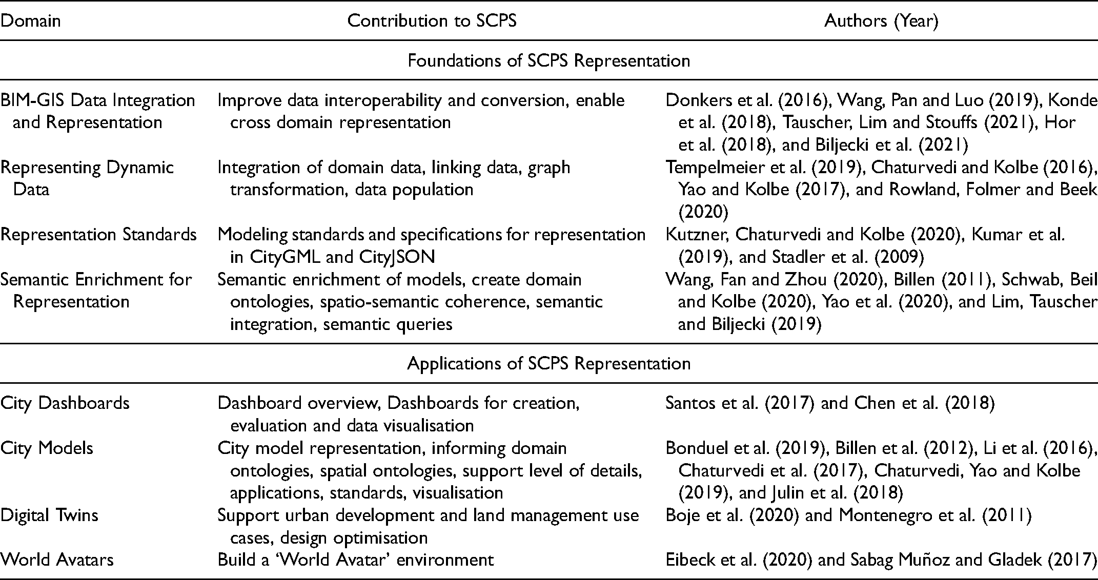
Literature for the Representational MP.
The literature for the Evaluative MP is organised in table 2. We group the literature in this section according to the various states of evaluation: single or multi-criteria; monitoring; and modeling:
Single or multi-criteria evaluation assesses to what extent one or more characteristics of an urban system have reached a certain target. Multi-criteria evaluation is applicable to complex assessment and reasoning tasks as well as to the development of ontologies. Monitoring refers to reporting and evaluating data-streams. Monitoring allows to link various data streams and feeds into platforms for urban analytics and semantic data integration for CIM. Modeling and Simulation refer to assessing time frames within which states change. Modeling tackles dynamic data integration as way to represent the multiple and temporal data-streams. Modeling for urban micro-climatic analysis as well as systems modeling are cited use cases.
Literature for the Evaluative MP.
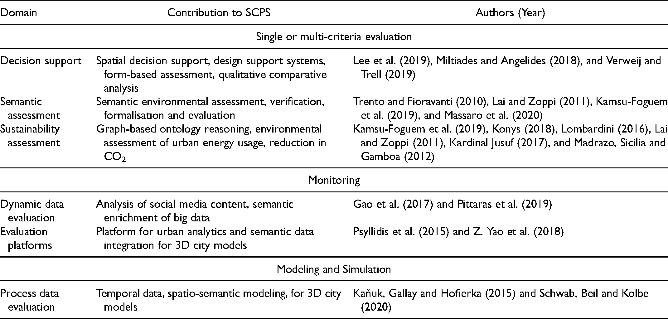
Literature for the Evaluative MP.
Projective MP
The literature for the Projective MP contains the least number of references - and we identify a clear lack of literature here. We attribute this to the fact that creation in design and planning processes is still under-researched and ambiguous (Cross 2007). To overcome this problem, systems of design or design frameworks have been developed (Coyne et al. 1990). Design Space Exploration (DSE) stands out as a strategy for automated exploration, evaluation, and optimisation of design solutions. Automated creation includes generative computational urban design and planning approaches. The linkage between shape grammars for urban form generation and ontologies promises to automate urban form generation. The literature organised in table 3 thus refers to generative processes of creating data, information and knowledge related to planning.
The literature is organised in table 4. This section contains the most references found at the intersection of SWT and CP. The synthetical MP that involves knowledge management enables data interoperability because all data is represented in ontologies that represent the semantic meaning of the data, rather than just their values. It further enables computational interpretation and synthesis, because all data has semantic meaning that is machine readable. It promises to open advanced planning support options, such as parallel simulation of multiple scenarios, automated generation of visualisations and analyses, knowledge inference, and iterative learning.
Literature for the Projective MP.
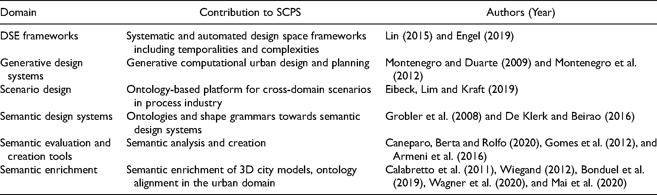
Literature for the Projective MP.
Literature for the Synthetical MP.
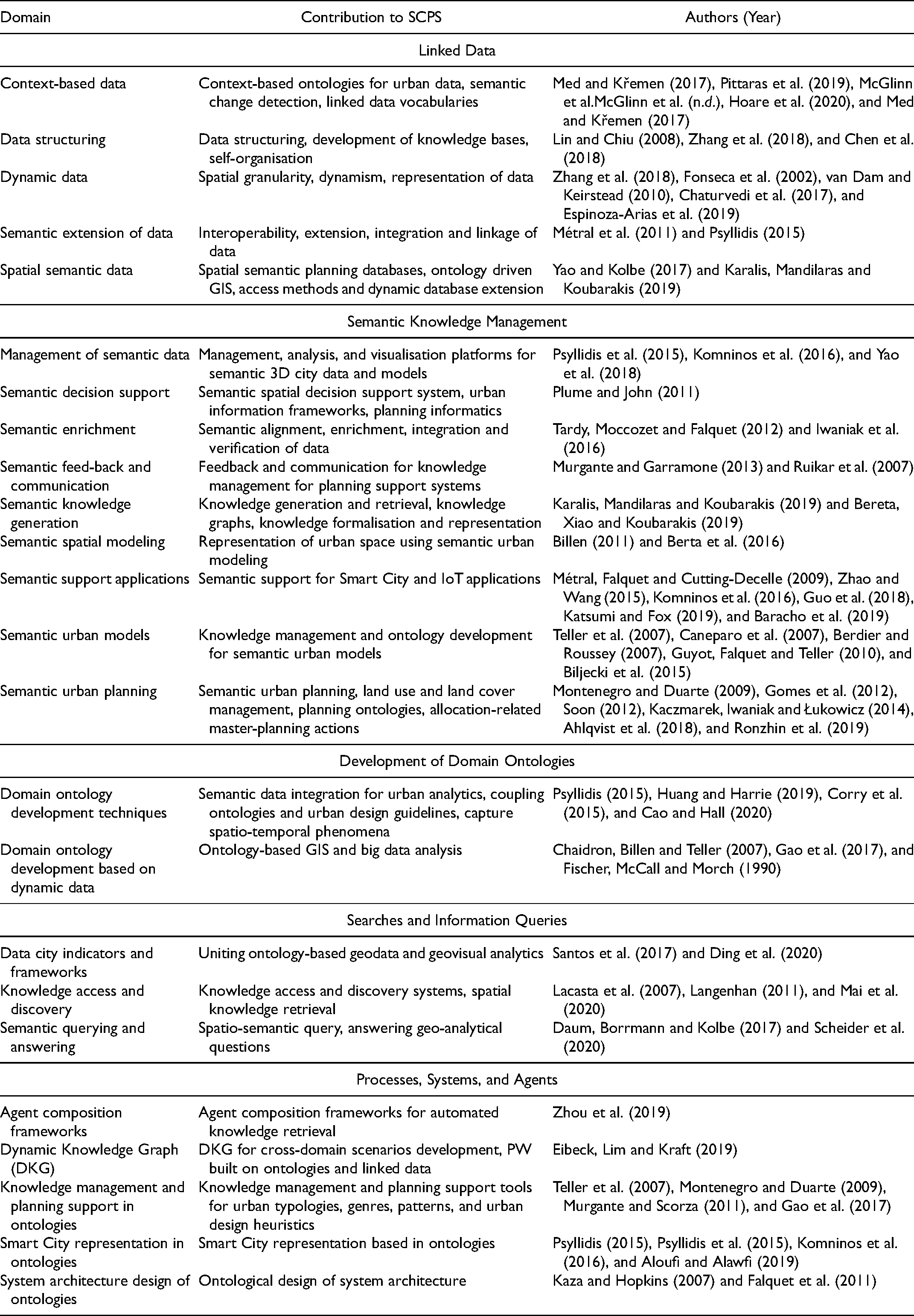
The Synthetical MP provides a clear foundation for SCPS: linked data allows to perform context-based and network proximity analysis; data structuring forms the base for self-organisation of knowledge bases; fundamental challenges of data interopreability can seemingly be resolved. The management of large and complex 3D urban data appears possible with the application of semantics to spatial concepts, urban modeling, communication, decision support, and knowledge generation. Further knowledge domains can be linked in via ontology development techniques and frameworks. We structure this section into Linked Data and Data Processing; Development of Domain Ontologies; Searches and Information Queries; and Processes, Systems, and Agents.
Linked Data addresses the core challenge of interoperability from a knowledge management perspective. It covers context-based data detection, dynamic data, spatial granularity, and management:
Semantic Knowledge Management covers semantic strategies for enrichment and spatial data integration. Development of Domain Ontologies follows similar topics with a focus of ontology creation and applications arising from it. These include knowledge generation, semantic design and decision support, semantic urban models and semantic urban planning. Searches and Information Queries relate to data structuring, as well as semantic querying and answering as methods to infer knowledge based on the descriptive logic of SWT. Processes, Systems, and Agents gathers literature around dynamic systems, agent compositions and systems architecture. Together, they support Dynamic Knowledge Graphs (DKG) for cross-domain scenarios - or Parallel Worlds (PW).
Reflecting on the scope of this review
We represented the scope of this paper as the intersection between SWT and CP. However SWT and CP should not be interpreted as monolithic conceptual wholes. The former's ability to support the latter will much more likely be demonstrated in terms of how particular components or methods of SWT support particular aspects or applications of CP - in the reviewed literature, this is almost exclusively the case. Hence, CP could adopt specific SWT principles or methods that best suit particular applications, domains, or Meta-Practices.
In addition, the potential benefits of applying SWT to CP should also be considered in terms of different ‘levels of technology’, going from simply creating a unified knowledge base of existing CP data (e.g. Ronzhin et al. 2019; Chadzynski et al. 2021a), over the automation of basic information gathering tasks in planning (e.g. Chadzynski et al. 2021), the ability to use novel or more performant multi-domain queries (e.g. Ronzhin et al. 2019; Grisiute et al. 2021), or extending our Ontological representations of planning knowledge (e.g. Montenegro et al. 2012; Katsumi and Fox 2019), to advanced applications such as setting up urban digital twins (e.g. Akroyd et al. 2021), running Parallel World simulations for planning (e.g. Eibeck et al. 2020) or integrating a CP AI through self-organising multi-agent systems (e.g. Zhou et al. 2019; Chadzynski et al. 2021b).
These more advanced applications of SWT highlight the role SCPS could play in pro- viding stepping stones for the ongoing integration of AI in planning tools, particularly approaches related to Knowledge Representation and Reasoning (e.g. to perform multi- domain reasoning across urban knowledge domains, or to develop assistive natural language processing interfaces for planners to interact with) or self-learning multi-agent systems (e.g. to explore design spaces for planning proposals, to automate urban scientific model calibrations using dynamic urban data-sets, or to simulate future development scenarios and trajectories). Of course, the integration of AI in human tools, particularly those tools supporting resource distribution decisions, brings with it a need to define and establish new boundaries, interfaces, and workflows of human-computer interaction. Such a discussion also needs to include on how to handle errors and limits of SWT while using such tools (Janowicz et al. 2016) A detailed discussion of the impacts of SCPS on the integration of AI and CP and the novel human-computer interactions that come with it is out of the scope of the present paper. Nevertheless, such discussions are already taking place and will only increase throughout the coming years - city governments, for example in Singapore (Huang 2021), are already developing AI tools and integrating SWT approaches to expand and strengthen the capacities of city planners. With this paper, we offer a framework to situate SCPS more clearly and its underlying technologies within the rapidly emerging paradigm of AI-supported planning tools.
Discussing gaps in literature and future directions
In the section 4 reviewing the state of the art of SCPS we found that the Representational MP 4.1 foregrounded visual information. This has many research and industry applications outside CP as visual information is essential for navigation and mapping. The Evaluative MP 4.2 focused on evaluating static data first and then moving onto more complex data and dynamic data. The Projective MP 4.3 collected basic practices of evidence-based planning support. This MP suffers from the complexity of planning tasks that often rely on dynamic processes that are not always visual or for that matter visible. We thus argue that the gaps point to three interconnected aspects of 1) Challenging visual primacy, 2) Moving from static to ‘live’, and 3) Evidence-based planning support systems based on city-science.
Conclusion
In this paper we offer a rationale for planners to take note of SWT and their promising applications to help address some of the fundamental challenges of the practice of CP and a relevant field within digital innovation. We present four meta-practices, Representational MP, Evaluative MP, Projective MP, Synthetical MP, expanding the disciplinary triad of representation, evaluation, and projection with the data-synthetic meta-practice emerging to address of the rise of ICT, big data, and AI in relation to planning. We create these four MP to gather dispersed research and join it by related themes. We identify emergent traits in the Synthetical MP literature, for it is the largest and most recent body of research. In contrast, the three others build up on disciplinary traits of design and planning. The tetrahedral model of meta-practices introduced in this paper (see figure 1) will allow to develop future SCPS. We argue that CP is predisposed to be adopt some form of SWT - as it becomes ever more aware of the growing interdependencies of cities - resulting from the greater scale, accelerated pace, and complexity of cities - that is currently met with disciplinary fragmentation. In the discussion section we propose effective areas for further studies. We hope this framework helps to clarify a multitude of approaches that, with this study, may be better understood in the future by the scientific community.
The presented literature on SCPS - at the intersection of CP and SWT - is thus not meant to be a ‘mechanical’ recipe for planning, but a guide to bring closer two groups of readers to the field of SCPS: geographers, city planners and urban studies scholars on one side - and data scientists, software developers and programmers on the other. We believe that the sketched synthesis between CP and SWT is going to be a new frontier for planning in the near future.
Footnotes
Declaration of Conflicting Interests
The author(s) declared no potential conflicts of interest with respect to the research, authorship, and/or publication of this article.
Funding
The author(s) disclosed receipt of the following financial support for the research, authorship, and/or publication of this article: This work was supported by the National Research Foundation Singapore (grant number NRF2019-THE001-0004).