
Abstract
The selection of suitable landfill locations for municipal solid waste has become a top priority, especially in developed countries as a result of rapid population growth, unplanned urbanisation, increasing waste production and the limited area available. However, determining the location of landfill sites is a complex decision-making problem for municipalities and depends on social, environmental, technical and economic factors and regulations. In this study, we combined a geographic information system (GIS), multi-criteria decision-analysis techniques and fuzzy logic to determine the best location for landfill sites in Adana, Turkey, in four steps. Firstly, the threshold values and the coefficient weights of 15 criteria, grouped into environmental and socio-economic factors, were determined by a literature review and expert opinion to select suitable landfill locations. Secondly, selection criteria were standardised using fuzzy logic. Thirdly, we assessed the criteria weights based on their effectiveness on the selection of potential landfill sites using the Simos method. According to the weight coefficients, environmental factors are more important than socio-economic factors. Final maps for each criterion were calculated and overlaid by a GIS. As a result, the final suitability results were divided into four discrete categories: very high, high, moderate and low suitability areas, representing 1%, 76%, 17% and 6% of the location options, respectively. Finally, four different alternative areas were identified as being very highly suitable for landfill locations, which were evaluated in detail using a strengths, weaknesses, opportunities and threats analysis. Three key aspects affect the final decision of a landfill site, in decreasing order of importance: environmental protection, minimising the negative impact on urban life quality and economic issues. Consequently, these results can guide decision-makers (ministries, municipalities, planners, etc.) during the selection of suitable landfill sites in both national and international studies.
Keywords
Introduction
Architects, planners and managers who identify the most suitable spatial decisions have widely used land use suitability to plan and manage the future of urban and rural environments (Collins et al., 2001; Demesouka et al., 2019; Malczewski, 2004). Public authorities and private developers use suitability maps and analyses to set policies and make decisions to select the best land use alternatives, because decisions regarding land use planning can negatively impact sustainability, the environment and urban health due to rapid population growth, urbanisation and limited land space (Demesouka et al., 2019; Khan et al., 2018; Torabi-Kaveh et al., 2016). Municipal solid waste (MSW) landfill site selection requires careful planning. The public and municipality attention paid to environmentally acceptable waste management policy has been increasing (Koda et al., 2017; Wong et al., 2016). The selection and construction of new landfill facilities is becoming increasingly challenging due to the lack of appropriate areas, requirements for increased landfill capacity and public resistance. Given the serious threat of landfill sites becoming a source of soil, water and air contamination, landfill sites should be selected carefully. For this reason, the candidate sites should comply with both strict national and international regulations (Demesouka et al., 2019). Municipalities are conscious of human health risks and environmental impacts associated with poor landfill management strategies (Joseph, 2006) and they are attempting to prevent these risks (Demesouka et al., 2019; Gbanie et al., 2013; Khan et al., 2018; Önüt and Soner, 2008; Soltani et al., 2015; Torabi-Kaveh et al., 2016).
The identification of suitable MSW landfill sites, as outlined in the literature, is a complex and multidisciplinary process encompassing environmental, ecological, social, economic and technical or engineering considerations (De Feo and De Gisi, 2014; Gbanie et al., 2013).Various methodologies and techniques for landfill site selection have been reported in the literature, including a geographic information system (GIS), mathematical models, heuristic algorithms and different multiple criteria decision-analysis (MCDA) methods, such as the analytical hierarchy process (AHP), the fuzzy analytical hierarchy process (FAHP) and techniques for order preference by similarity to ideal solution (TOPSIS). Most of the methodologies are based on the combination of spatial techniques and approaches, such as GIS-based MCDA techniques. The GIS is a powerful tool that helps manage large volumes of spatially distributed data from a variety of sources to evaluate multiple criteria and conflicting policy objectives. It efficiently stores, retrieves, analyses and displays information according to user-defined specifications (Alavi et al., 2013; Sener et al., 2006; Siddiqui et al., 1996; Wang et al., 2009). In this study, we used a GIS to perform an initial screening process to eliminate unsuitable areas, mainly working at the macro-siting level, followed by the use of MCDA to select the most suitable sites.
GIS-based MCDA is an intelligent system that converts spatial and non-spatial data into valuable information, which, in addition to the judgement of the decision-maker, can be used to make critical decisions (Chen et al., 2010; Gbanie et al., 2013; Sumathi et al., 2008). GIS-based MCDA requires a variety of geographically referenced data and a set of alternatives with a series of evaluation criteria. This system aggregates the criteria maps in accordance with attribute values and the preference of the decision-maker (Malczewski, 2004). Approaches to MCDA, including the AHP, analytic network process (ANP), weighted linear combination (WLC) or simple additive method (SAM) and fuzzy logic, have widely been used in the identification of potential landfill sites (De Feo and De Gisi, 2014; Gbanie et al., 2013; Khan and Faisal, 2008; Khan et al., 2018; Kontos et al., 2005; Sener et al., 2006; Şener et al., 2010; Sultana and Kumar, 2012; Sumathi et al., 2008; Wang et al., 2009). However, the MSW landfill location suitability evaluation data for various subjective criteria and the weights of the criteria are usually expressed in linguistic terms; fuzzy logic is a more natural approach to this kind of problem (Önüt and Soner, 2008). Hence, many researchers have attempted to use fuzzy multiple criteria decision-making methods for waste management problems (Chang et al., 2008; Gbanie et al., 2013; Moeinaddini et al., 2010; Önüt and Soner, 2008; Torabi-Kaveh et al., 2016). Fuzzy logic can go further and create a compromise that satisfies stakeholders and helps them communicate their different preferences to reach an agreement.
The land use optimisation issue for MSW landfill site selection is particularly important in countries with advanced environmental legislation, a high degree of urbanisation and low availability of potentially suitable areas (De Feo and De Gisi, 2014). From 2002 to 2016 the total amount of waste generated in Turkey (excluding contaminated soil, sludge and manure) increased from about 25,373,000 to 31,584,000 tonnes; in the same period, the amount of waste that was delivered to controlled landfill sites increased from 7,047,000 to 19,338,000 tonnes, representing a 61.2% increase in waste generated in Turkey (TSI, 2018). The increase in the amount of waste in the region compared to previous years shows the need to create new landfills. For this purpose, the choice of alternative landfill sites is crucial.
The rapid population growth of Adana, Turkey, has led to an ever-increasing production of waste and expansion of industries and urban development, which, in turn, have complicated the issue of urban waste collection and disposal. The existing MSW facility in Adana is located in the centre of urbanisation, negatively affecting social life and causing odour and pest problems. The special unique condition of this city increases the need for appropriate site selection for the new planned landfill. To reduce the negative impacts of MSW in Adana, the use of recent tools and technologies to identify a suitable landfill site is necessary.
The aim of this study was to define a methodology for landfill site selection based on the combination of a GIS, multi-criteria evaluation techniques and fuzzy logic to (i) systematically analyse the range of environmental and socio-economic factors that influence site selection, (ii) to determine alternative suitable landfill sites while optimising the land use in the area by avoiding wasting space and protecting the environment and urban health and (iii) guide decision-makers to select the most reliable, suitable and applicable landfill sites in the province of Adana, Turkey.
Materials and methods
Study area
The study area consists of four selected districts (Çukurova, Seyhan, Sarıçam and Yüreğir) in the Adana province in Turkey, an urban context that is characterised by a high density of urban settlements, the most densely developed and crowded areas (Figure 1). Adana city, bounded by the Mediterranean coast, which is 160 km to the south, has an area of 14,125 km2. The city centre is 23 m above sea level. Adana has a typical Mediterranean climate, with cool, wet winters and hot, dry summers. The mean daily maximum air temperature is approximately 31°C in July and August (the hottest period), and approximately 15–16°C in January and February (the coldest period). The weather in August is arid with no rainfall. However, during the year, the daily mean relative humidity remains high (above 80%). The dominating wind direction in Adana is northeast in winter and southwest in summer (Turkish State Meteorological Service, 2017).
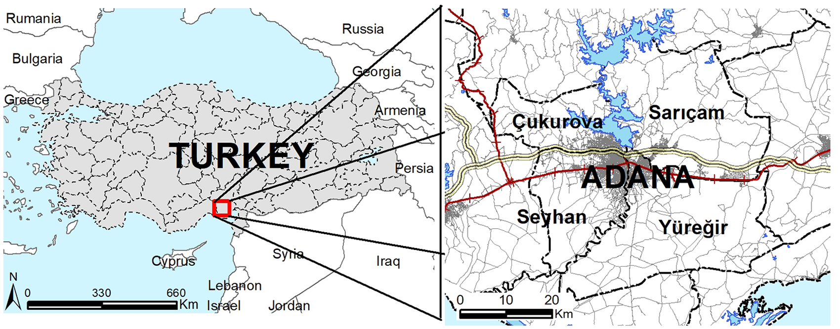
The study area of Adana, Turkey.
Adana is the fifth most crowded city of Turkey. Agricultural and agricultural industries have developed because this area covers the most productive agricultural land in the country. This development created a significant level of employment, resulting in intense internal migration from rural to urban areas (Unal and Uslu, 2018). The population was 500,000 at the beginning of the 1980s, rising to about 2,220,125 in 2018 (TSI, 2018). The development and improvement plans for Adana prepared for 1985–2015 have been prioritised to meet housing needs due to the increasing population in the four districts in the city centre (Altunkasa et al., 2011, 2017). An average of 2000 tonnes of domestic solid waste from the residential, commercial and institutional facilities is collected daily at the Adana Municipality Integrated Solid Waste Disposal Facility. Consequently, this situation leads to an increase in the solid waste produced by intensive urbanisation, increasing the need to plan an alternative solid waste management solution for this dense urban settlement.
Methodology
This study’s methodology includes four stages (Figure 2), as follows.
Determination of landfill site selection factors collected by referring to the literature.
Application of multi-criteria analysis (MCA), including the following: ○ determination of layers; ○ standardisation of criteria by fuzzy logic; ○ determination of the weight of the criteria by the Simos method; ○ overlapping layers to map the MSW landfill suitability.
Determination of planning strategies by strengths, weaknesses, opportunities and threats (SWOT) analysis for suitable areas where MSW landfill facilities can be established.
Developing suggestions according to the findings.
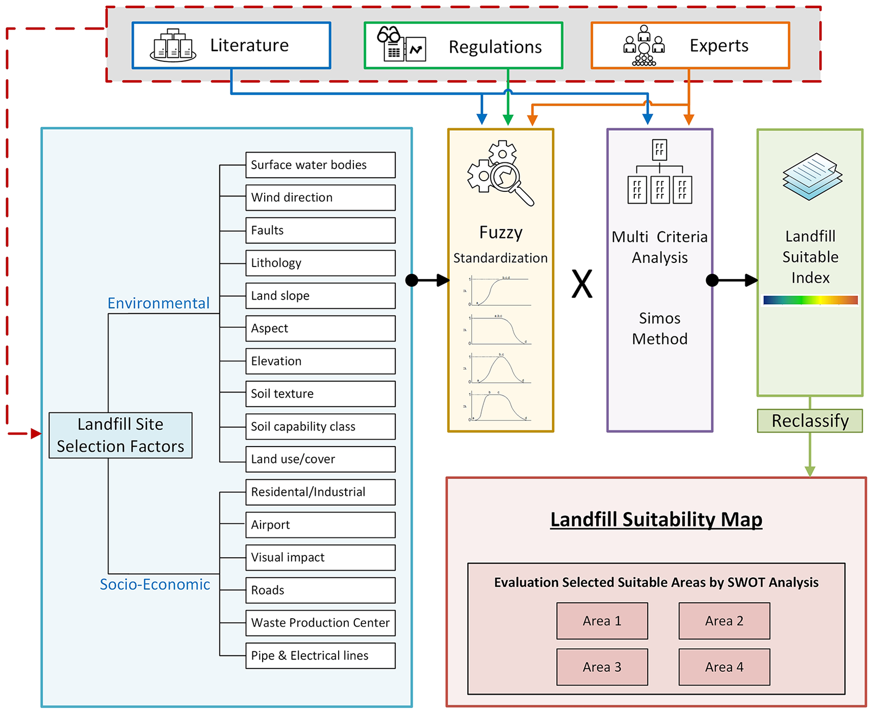
Flowchart of the study.
Landfill site selection factors
The selection of a landfill site requires an extensive evaluation process to identify the most suitable location considering environmental, economic, sociological, technical and political aspects (Ersoy and Bulut, 2009; Nas et al., 2010; Soltani et al., 2015). The landfill site should avoid impacts as much as possible on the environment, public health and safety, and prevent any interaction with other natural and human-made systems (Gorsevski et al., 2012; Soltani et al., 2015). The principal concerns during site selection are environmental protection and public health and safety (Kontos et al., 2005; Önüt and Soner, 2008; Sumathi et al., 2008).
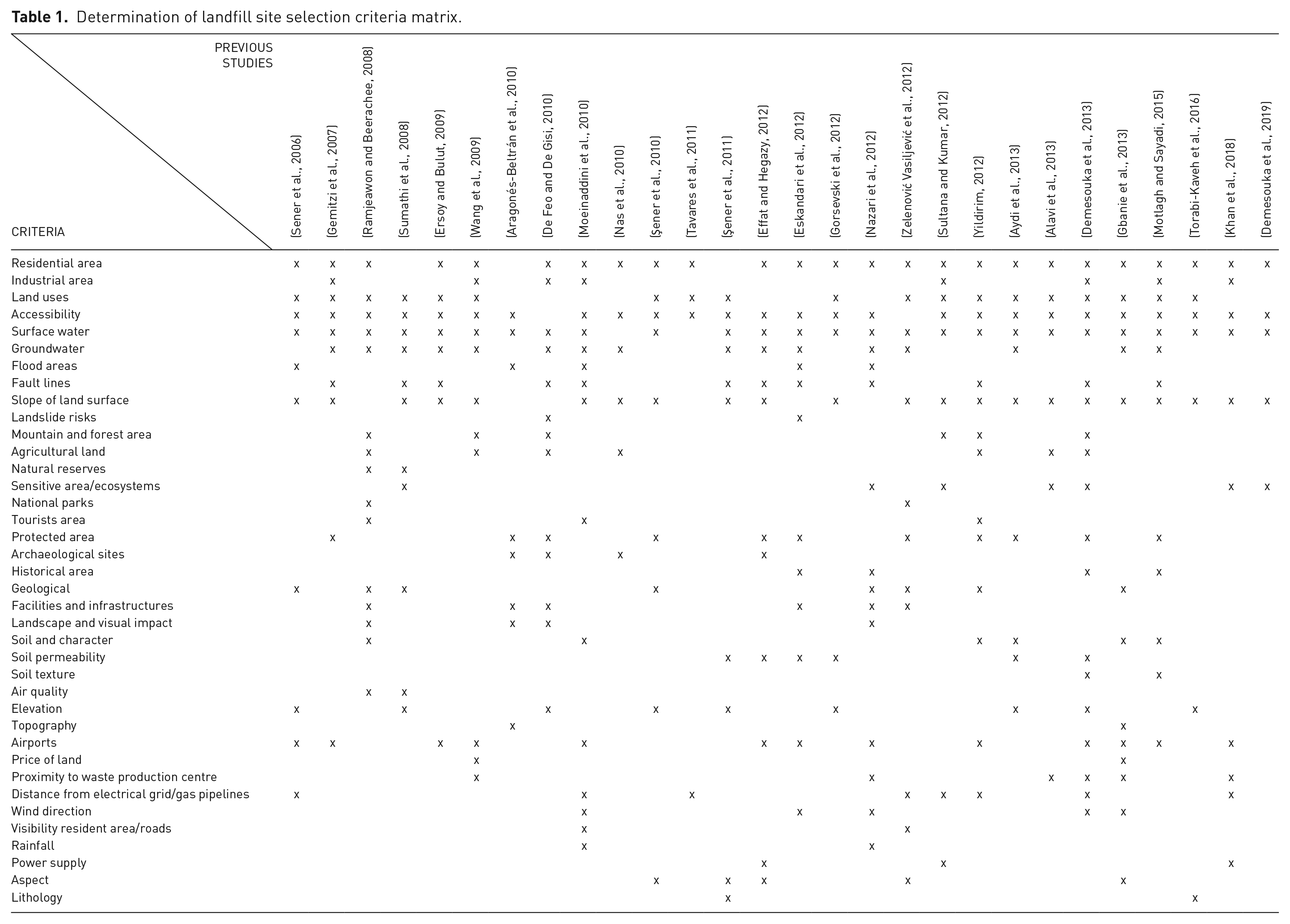
In this study, criteria were identified based on a literature review (Table 1). We examined 38 criteria in previous studies and eliminated their similarities. In many studies, the evaluation criteria of solid waste disposal sites were mainly categorised into two or three factor groups, including environmental or natural, social, economic and technical factors (Aragonés-Beltrán et al., 2010; Demesouka et al., 2013; Effat and Hegazy, 2012; Ersoy and Bulut, 2009; Eskandari et al., 2012; Gbanie et al., 2013; Gorsevski et al., 2012; Motlagh and Sayadi, 2015; Nazari et al., 2012; Ramjeawon and Beerachee, 2008; Şener et al., 2010, 2011; Su et al., 2007; Tavares et al., 2011; Torabi-Kaveh et al., 2016; Tuzkaya et al., 2008; Wang et al., 2009; Zelenović Vasiljević et al., 2012). Table 1 lists the studies, presenting the different criteria used in studies performed over the last 15 years.
Determination of landfill site selection criteria matrix.
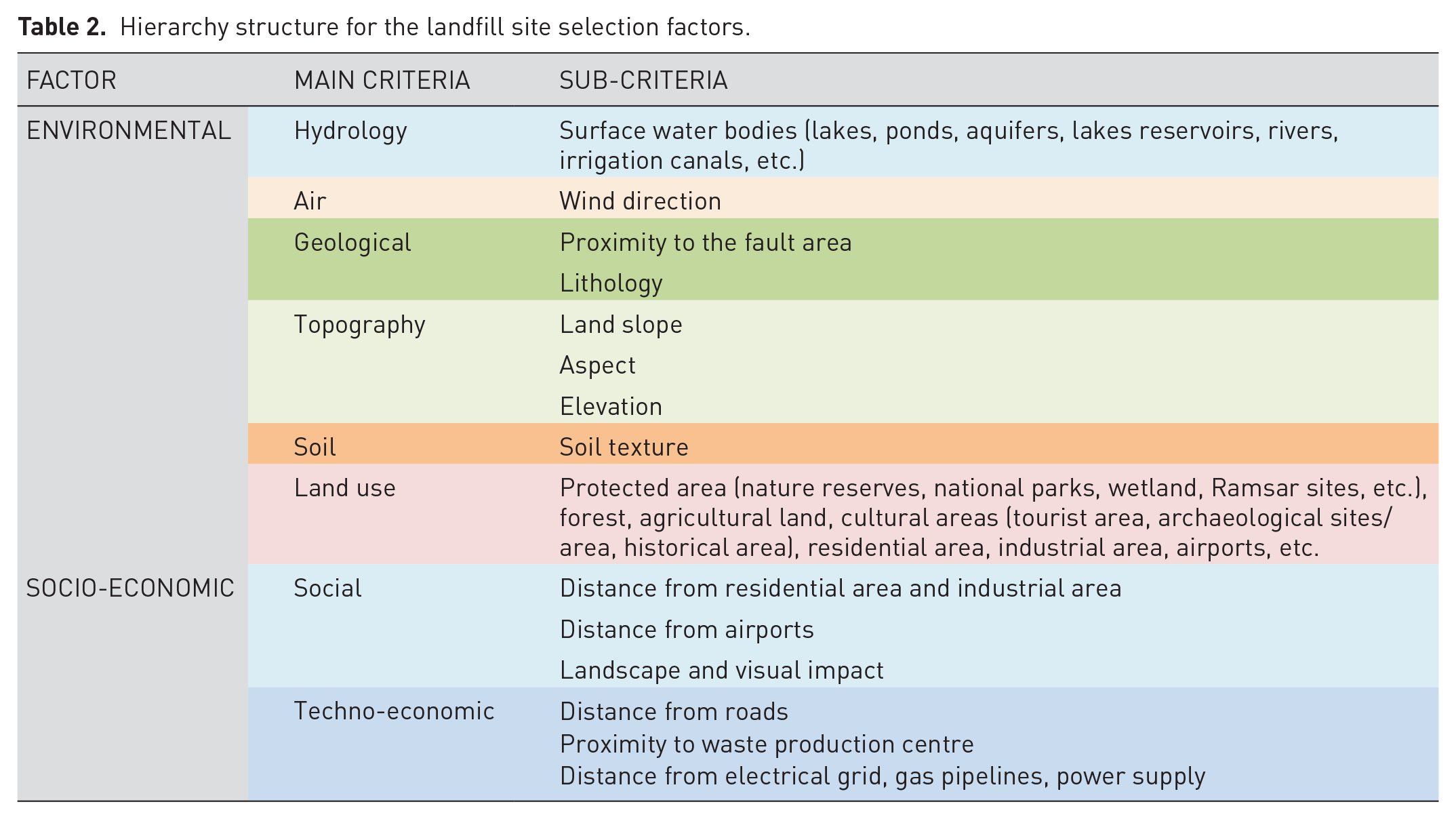
Secondly, two main categories of factors (environmental and socio-economic factors), eight main criteria and 15 sub-criteria were determined to evaluate different alternative waste disposal sites. The environmental factors included hydrology, air, geological, topography, soil and land use criteria; the socio-economic factors included social and techno-economic criteria. Environmental factors are considered to minimise the environmental impacts of the MSW locations and socio-economic factors are considered to minimise the cost of MSW areas, both during the construction and operation phases. Table 2 shows the hierarchy structure for the landfill site selection factors.
Hierarchy structure for the landfill site selection factors.
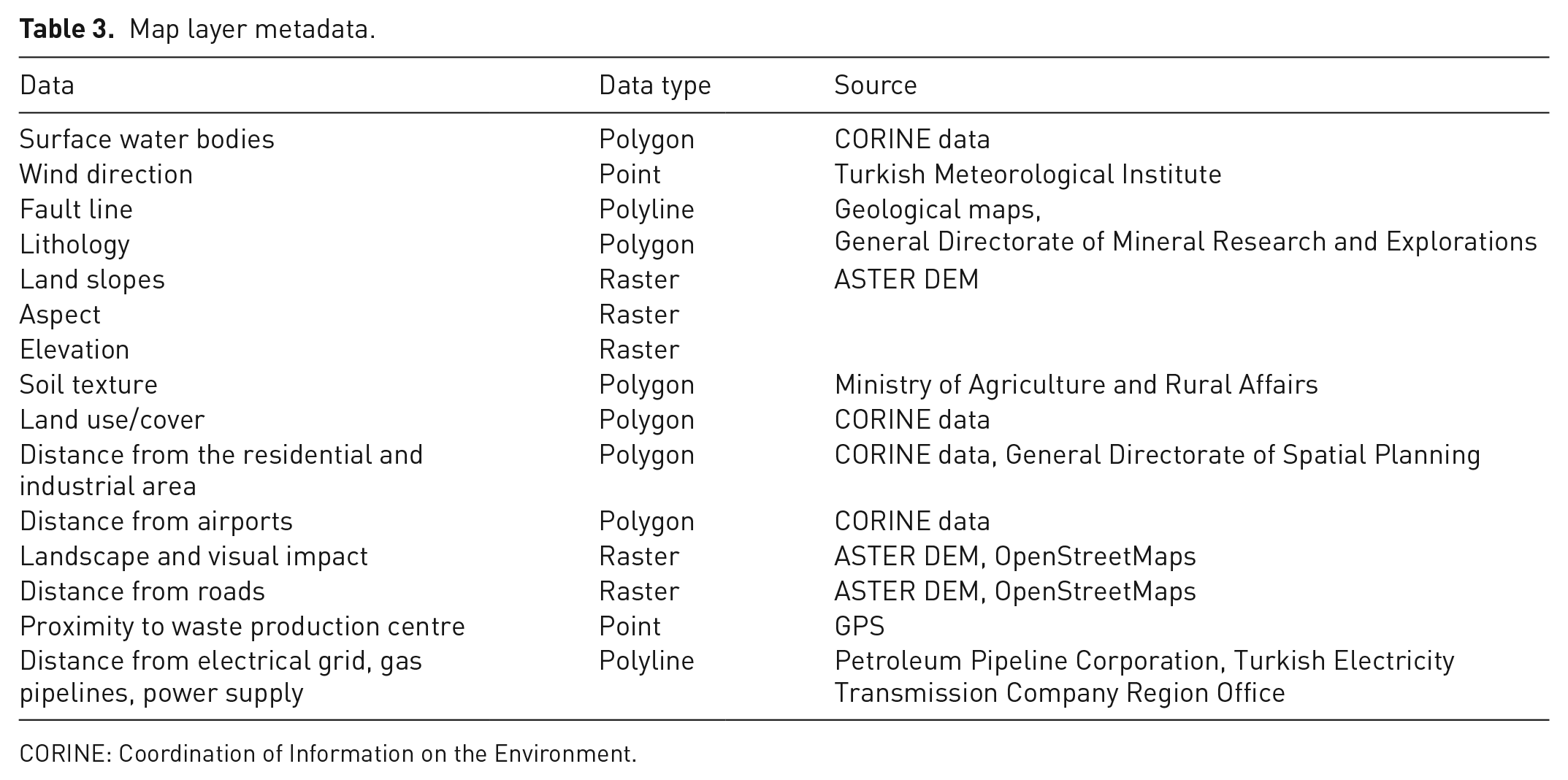
Data
For each factor, we created map layers affecting the process of landfill site selection for use in the GIS database. These datasets were provided by different databases and institutions (Table 3). The soil data were generated from the General Directorate of Rural Services within the Ministry of Agriculture and Rural Affairs as a polygon data layer. Data included soil group class, current land use, land use capability class, land type, agricultural land class and subclass. We gathered soil hydrological characteristics, including permeability and soil texture information for each soil unit, from previous studies and scientific reports for Adana city (Cilek, 2017; Cilek and Berberoglu, 2019). The Coordination of Information on the Environment (CORINE) land cover data supplied from the Ministry of Agriculture and Forestry were used to extract residential area, airports and surface water bodies information. Airport data were then precisely digitised as a polygon data layer over the high-resolution satellite images and topographic maps. Three airports were identified around Adana: two civilian (one of them was under construction) and one military. Residential and industrial areas were digitised over the high-resolution satellite images on the basis of the current and urban and industrial development zones of the region. The global 30-arc-second Digital Elevation Data from the Advanced Spaceborne Thermal Emission and Reflection Radiometer (ASTER) satellite sensor were used to characterise the elevation, slope and aspect at a 30 m resolution. The data for lithology, fault lines, and streams and surface water were derived by 1/100,000 scale geological maps. Seven different lithological groups were classified according to different types of rocks. The road network map was generated by OpenStreetMap, topographic maps and high-resolution satellite images and included major roads and other roads. Pipelines were provided by the Petroleum Pipeline Corporation, and power lines were digitally provided by the Turkish Electricity Transmission Company Region Office.
Map layer metadata.
CORINE: Coordination of Information on the Environment.
Multi-criteria analysis
The second phase for determining site suitability for MSW landfills is the MCA, combined with fuzzy function standardisation in a GIS environment. multi-criteria decision making (MCDM) methods deal with the process of making decisions in the presence of multiple criteria or objectives. A decision-maker is required to choose among quantifiable or unquantifiable and multiple criteria. The objectives are usually conflicting; therefore, the solution is highly dependent on the preferences of the decision-maker. MCDM methods can also be integrated with fuzzy methods to manage uncertainties in the data. Many researchers have attempted to use fuzzy MCDM methods for selection problems (Önüt and Soner, 2008; Pohekar and Ramachandran, 2004). In this study, MCDM was also used to systematically analyse the criteria and determine suitable landfill sites. Therefore, MCDM is applied in four main steps: determination of layers, standardisation, weighting and map overlay.
Determination of layers
the first step is identifying the layers affecting the suitable MSW landfill area. In this study, we aimed to evaluate and analyse the natural and socio-economic factors in the selection of suitable areas for MSW disposal facility in terms of ecological and economic aspects. In this context, a large dataset containing natural and socio-economic factors was produced for the study area. We adopted 15 evaluation criteria to help decision-makers to compare criteria more easily (De Feo and De Gisi, 2010; Saaty, 1990, 2008). Each criterion was then defined as a map layer for systematic analysis and we obtained different thematic maps.
Standardisation
the important step after defining the layers is the standardisation of criteria, because some criteria are nominal data (i.e. land use, wind direction, lithology) and others are numerical data (i.e. distance from residential area, industrial area, airport, water bodies). Fuzzy logic is one of the most common methods used to standardise different data types (De Feo and De Gisi, 2010; Forman and Selly, 2002; Saaty, 1990, 2008). Therefore, each map layer was introduced as a standard; the standardisation of factors was conducted based on the fuzzy logic. Fuzzy logic, first introduced by Lotfi Zadeh (1965), has established various applications in different fields for uncertain knowledgeable values. The weights assigned are not only numbers 0 and 1, in contrast to the Boolean variations between these values. The Fuzzy Membership tool reclassifies or transforms the input data to a 0 to 1 scale based on the possibility of being a member of a specified set. Zero is assigned to locations that are definitely not a member of the specified set, 1 is assigned to values that are definitely a member of the specified set and the entire range of possibilities between 0 and 1 are assigned to some level of possible membership. The larger the number, the greater the possibility. Fuzzy functions are used to evaluate the probability of each pixel of a fuzzy set by evaluating any of a set of fuzzy set membership functions. The fuzzy standardisation process can be configured with the control points obtained from the highest and lowest values on the sigmoidal (S-shaped), J-shaped, linear and user-defined function scale. Control points in the sigmoidal function are defined by monotonically increasing, monotonically decreasing and symmetric configurations (Figure 3). When ‘monotonically increasing’ or ‘monotonically decreasing’ curves are chosen, only two control points are needed to define the fuzzy set membership function. In the first case, they are point a and point b, while in the second case, they are point c and point d. When the ‘symmetric’ curve is chosen, however, all four control points are needed and must be entered in the following order: a, b, c and d (Eastman, 2003).
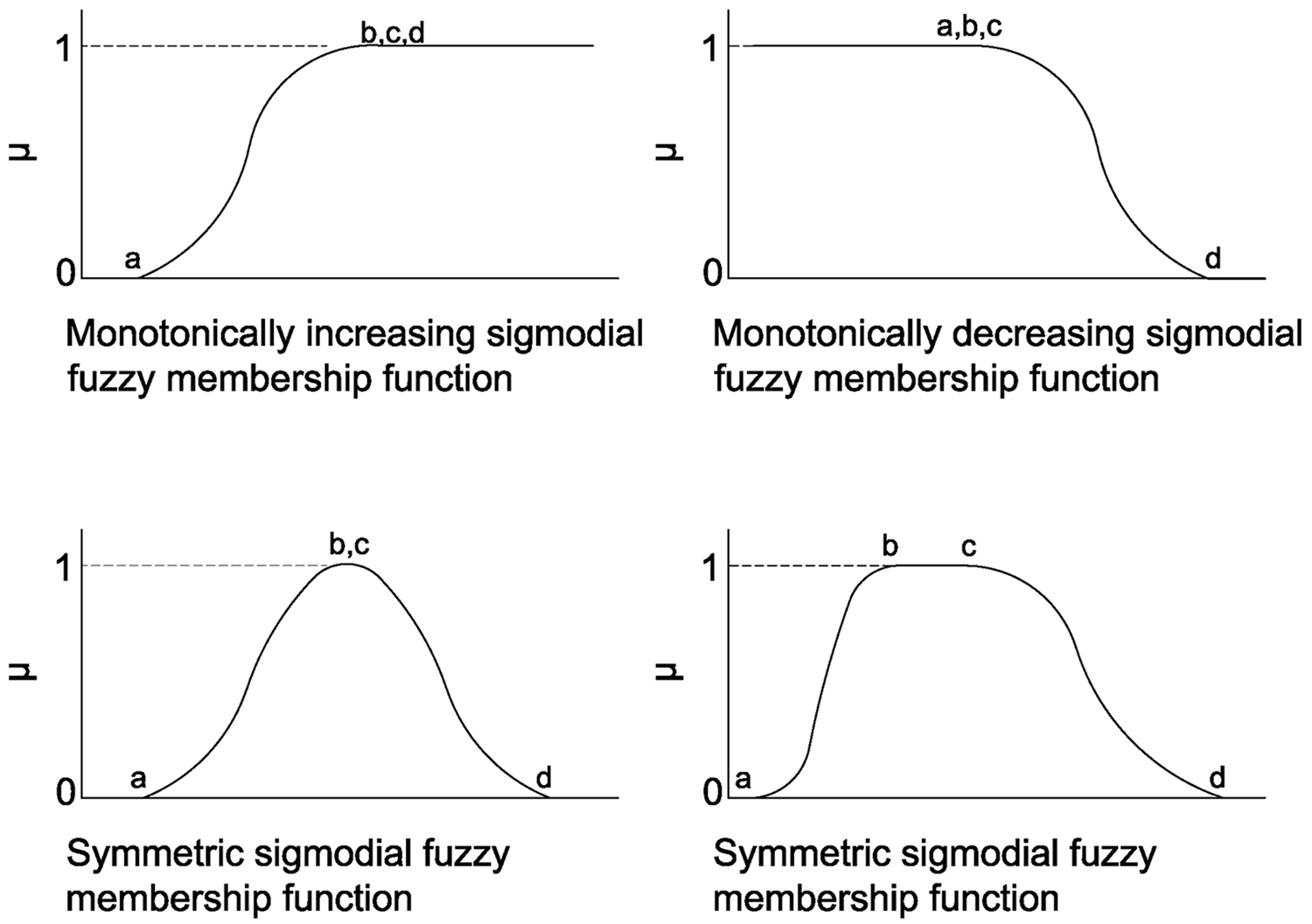
Sigmoidal functions in fuzzy standardisation.
Weighting criteria
MCDM demands the assigning of weights to the various criteria considered in the analysis. Weights allowing the decision-makers to specify the perceived importance of individual factors determine the level of importance of each criterion relative to the others and account for the degree of compensation for each factor in the factor group (Gemitzi et al., 2007).
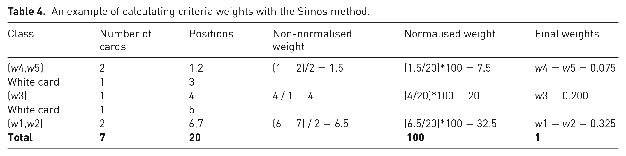
The Simos method was used to determine the general weight coefficients of the criteria applied from the literature and expert opinion. This method is one of the support mechanisms that facilitates and improves the understanding of the scale factor weighting processes. The Simos model is based on the approach of associating each criterion with a ‘playing card’. Table 4 provides an example of the ranking of five cards, taking into considering the number of white cards. Several algorithms are used to calculate the weights of the criteria with the Simos method. Participants rank these cards (or criteria) in order of their importance, from the least to the most important. The order of the criteria refers to the importance the participant wants to assign to these criteria. In the ranking, the first criterion is the least important and the last criterion is the most important. If two criteria are stated to be equally important, they are ranked the same. Another set of cards (white cards) is introduced to enable participants to confidently choose between criteria. The participants are asked to insert a white card between two consecutive coloured cards; the number of white cards is proportional to the difference between the criteria considered. Then, the normalised weight of each criterion is determined by dividing the non-normalised weight of the ranking by the total position of the criteria (without considering white cards). Normalised weights are written by rounding to a lower or higher integer. The non-normalised weight of each rank is determined by dividing the sum of the positions of the considered criteria by the total number of criteria belonging to this rank (Figueira and Roy, 2002; Wang et al., 2009) (Table 4).
An example of calculating criteria weights with the Simos method.
Map overlay
the final step of MCDM is the overlapping of multiple datasets using a GIS. Overlapping enables the combination of characteristics for numerous layers into a single layer in a map to monitor and to model (Carver, 1991). This approach is often used to rank attribute values by suitability or risk, then add them to produce an overall rank for each cell. The various layers can also be assigned a relative importance to create a weighted ranking. The ranks in each layer are multiplied by that layer’s weight value before being summed with the other layers. Thus, the suitable MSW landfill sites were mapped on the basis of environmental and socio-economic factors to guide the problem facing decision-makers, while taking into considering conflicting views and objectives.
SWOT analysis
The last stage of the evaluation process for suitable MSW landfill is the SWOT analysis, which is a useful technique for identifying various factors, including the SWOT of a programme or any other related activity. SWOT analysis can be used to interpret a plan under complex conditions. The choice of a suitable MSW landfill selection is a complex process; therefore, a SWOT analysis is required to ensure the correct selection of a suitable MSW landfill area. The application of SWOT analysis could help with developing strategic action plans to improve appropriate MSW landfill decision strategy (Aich and Ghosh, 2016; Koderi et al, 2018; Mor et al., 2016). Once suitable areas are listed, then the positive and negative contributions of the various criteria to the suitability of the proposed MSW landfill areas are evaluated. Finally, planning suggestions were developed according to SWOT analysis findings.
Results and discussion
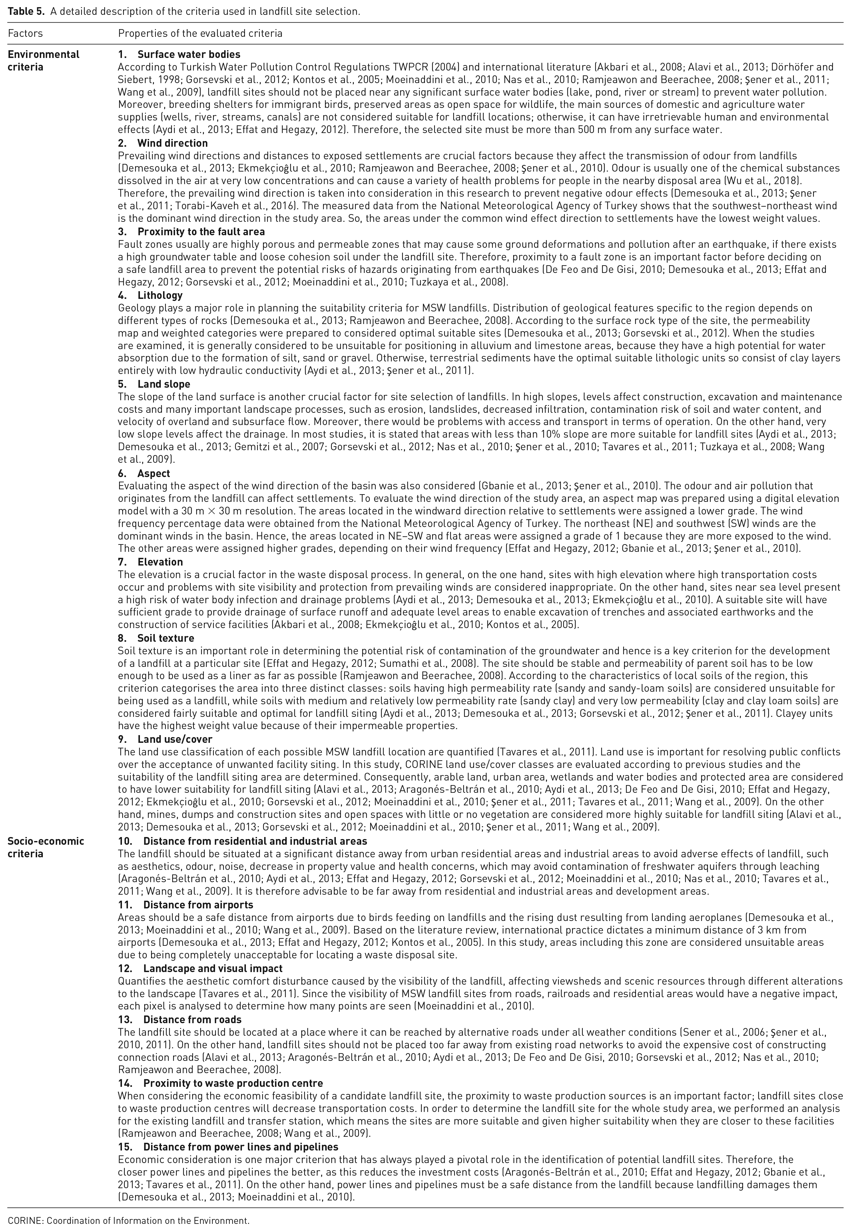
A landfill must be situated and designed to preserve the environment and safeguard public health. Therefore, the determination of landfill site selection criteria was one of the most important steps in this study. Another important step was determining the reasons for selecting the criteria determined and to determine the required limit values for fuzzy evaluation. In this context, 28 studies over the last 10 years were examined and 16 criteria were separated into two main factors, environment and socio-economic, to enable suitable site selection. In the determination of the criteria, the usability of the selected criteria, data accessibility and applicability to different regions were considered. The most frequently used criteria and value scores were selected and evaluated by experts in the field. A detailed description of the factors used in this study is provided in Table 5 and the evaluation of the criteria is outlined in Table 6.
A detailed description of the criteria used in landfill site selection.
CORINE: Coordination of Information on the Environment.
Factors, weighted scores, fuzzy membership function type and references for municipal solid waste landfill.
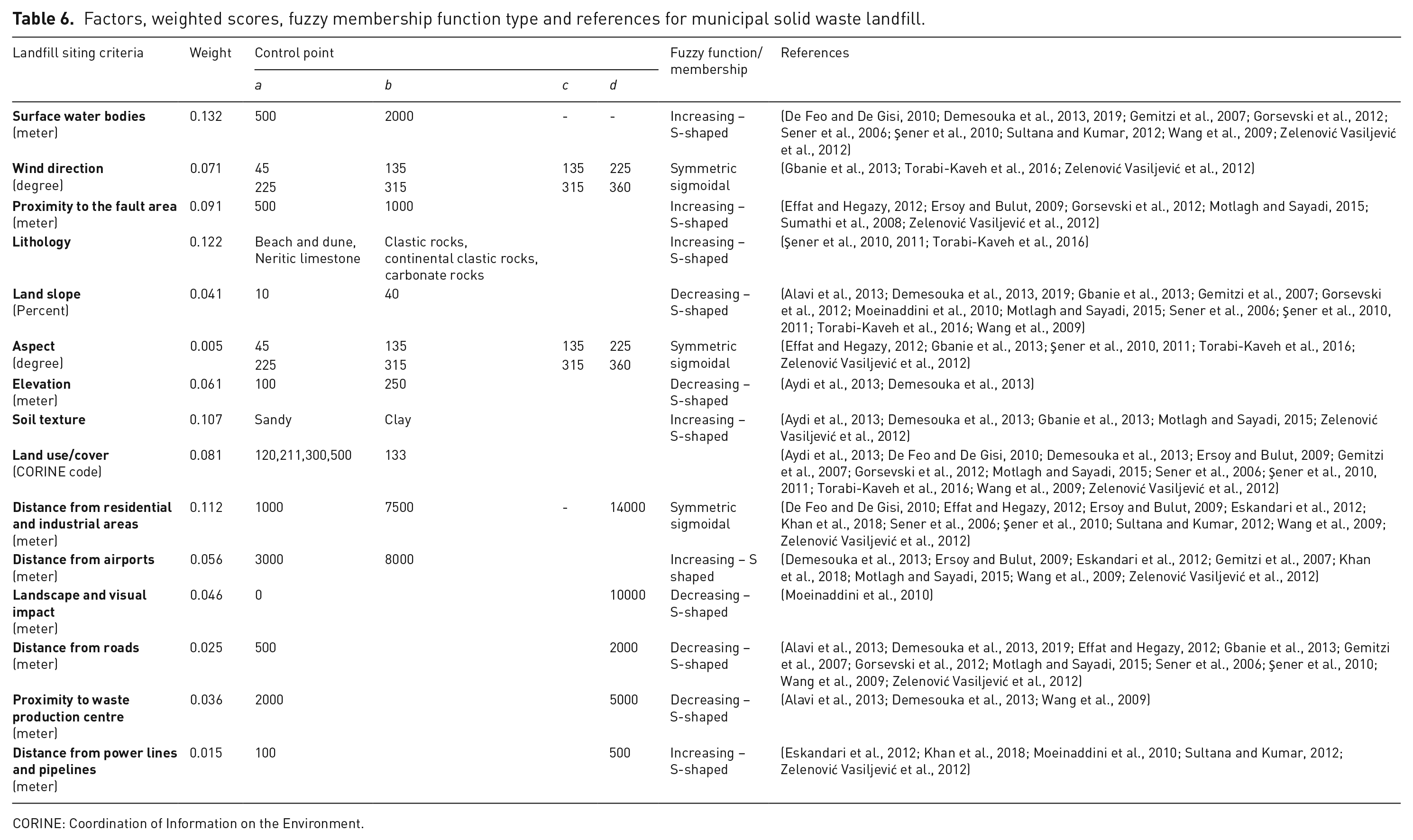
CORINE: Coordination of Information on the Environment.
In summary, a landfill must be located and designed for preserving the environment and reducing the impact of pollution on public health. Areas unsuitable for landfill sites include steep slopes, urban settlements and industrial areas, airports, surface water bodies, areas with faults, areas with a dominant wind direction, those with certain land use, and those with certain lithology. Landfill sites should be situated far away from that with these criteria. On the other hand, the landfill site should be placed as close as possible to existing roads to reduce the need for road development, to the waste production centre to reduce transportation costs and to power lines and pipelines to reduce investment costs. This study was partly based on the relevant Turkish Solid Waste Control Regulations, in addition to international practices that consider environmental and socio-economic factors. This paper also demonstrates the applicability of such methodologies to different areas of study at the international level due to the integration of criteria evaluation and methodology obtained from national and international scientific studies.
The data prepared in the GIS database were standardised with a fuzzy method to align the scales. Each criterion was scaled between 0 and 1 using fuzzy membership methods in accordance with the literature, regulations and expert opinions for compliance with MSW facilities. The fuzzy function applied to the criteria and the values used are provided in Table 6 and their maps are depicted in Figure 4.
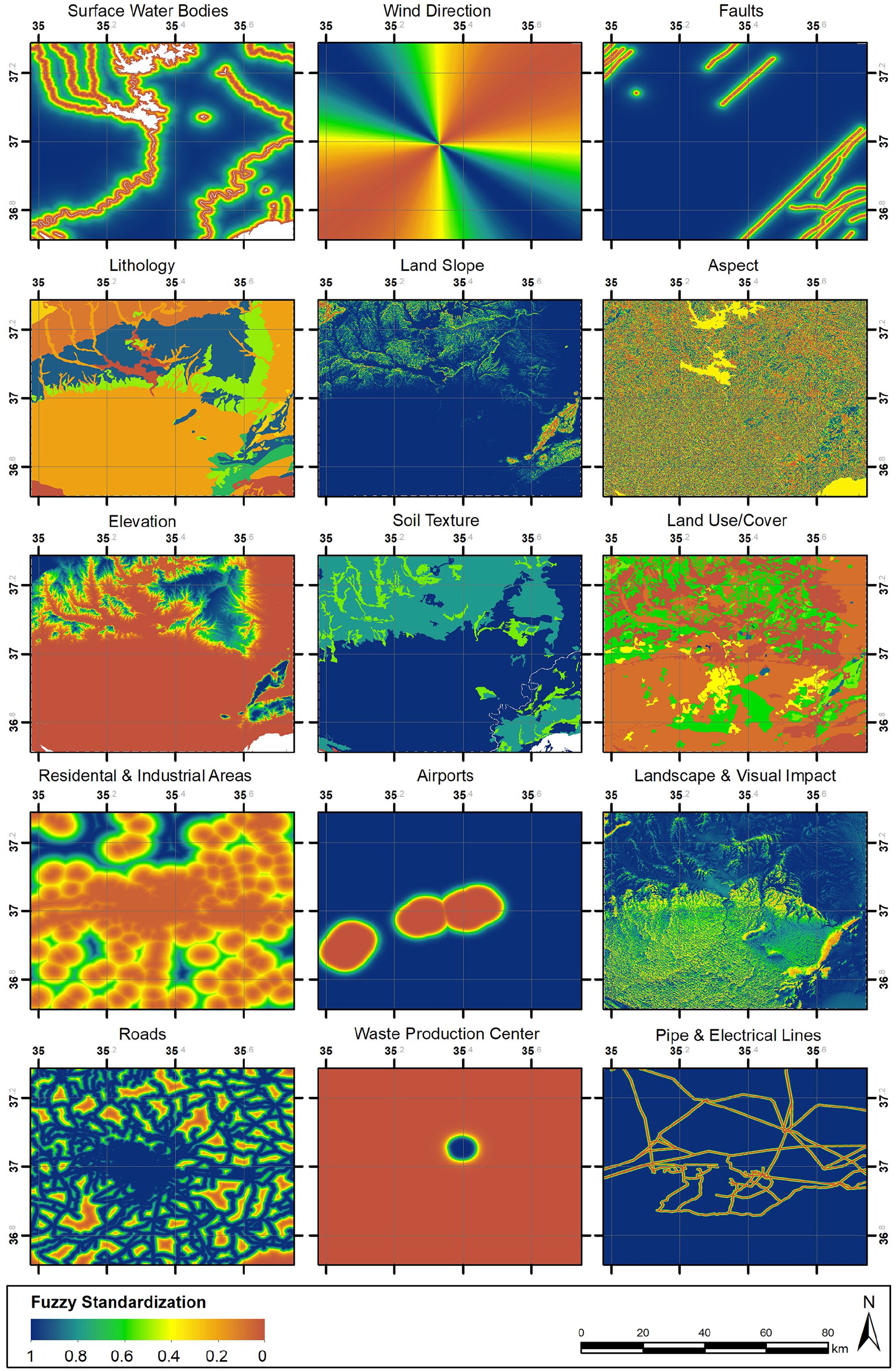
Spatial distribution of fuzzy standardisation maps for each criterion.
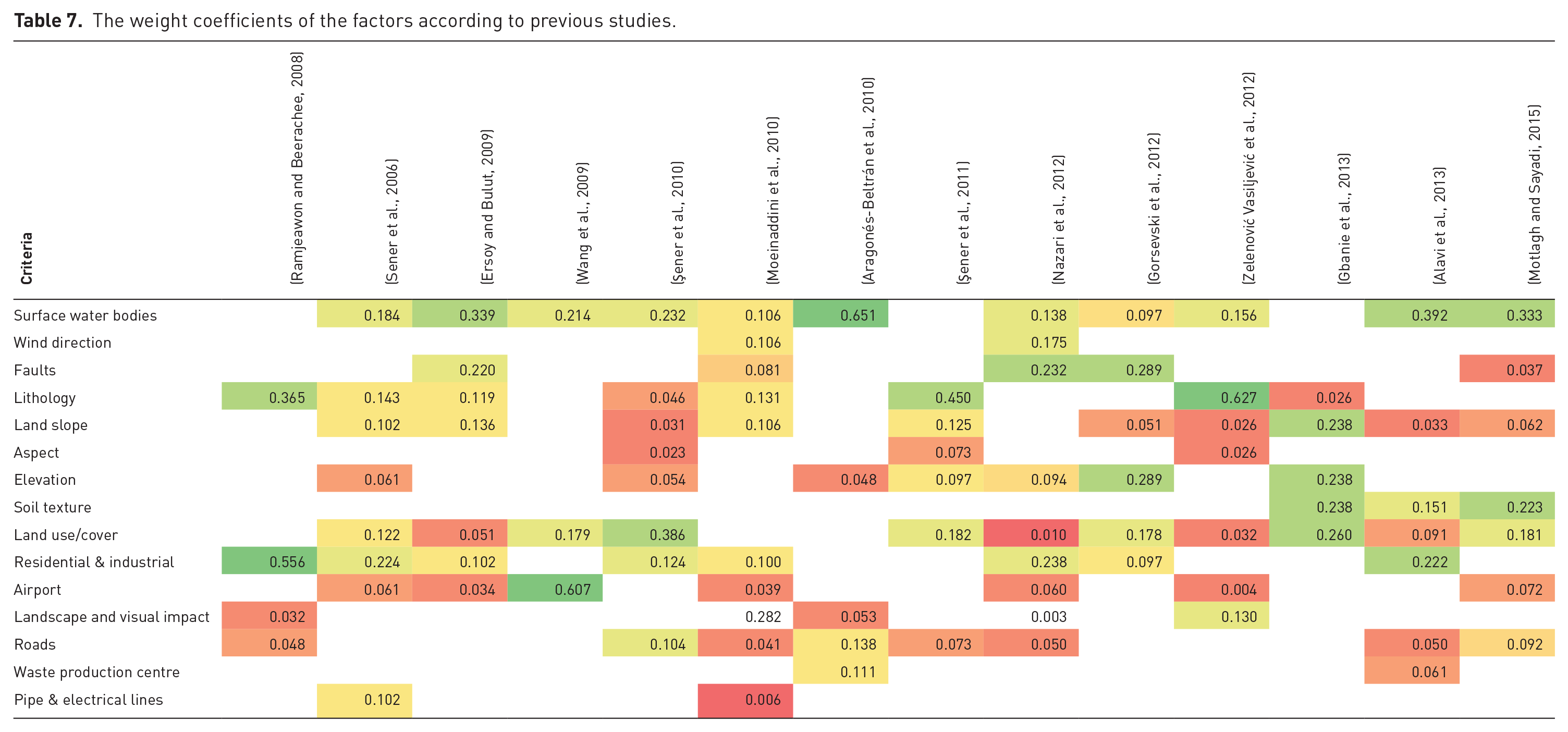
After the standardisation process, the factors for the MSW facility were weighted according to the literature and experts, given the differences in the evaluated importance of these factors (Table 7). In the decision-making process, we evaluated different concepts for data analysis, evaluations, mergers and documentation. MCA is the most common method used in decision-making. A GIS, programming languages or statistical software are used extensively in applications to multi-criteria decision-making processes. In the weighting process, the factors are sorted according to their importance and a coefficient is created for each using the Simos method, which is one of the MCA methods. The significance levels of the factors were determined in accordance with the coefficients in the literature and the opinions of experts. The weight coefficients of the factors found in 15 different articles were evaluated and their significance and the weight degrees between each other were calculated. In addition to this assessment, the data were evaluated with 10 expert opinion values. The weight coefficients of the factors used in this study were calculated according to the Simos method and are listed in Table 8.
The weight coefficients of the factors according to previous studies.
The calculation of the Simos method of the criteria weight.
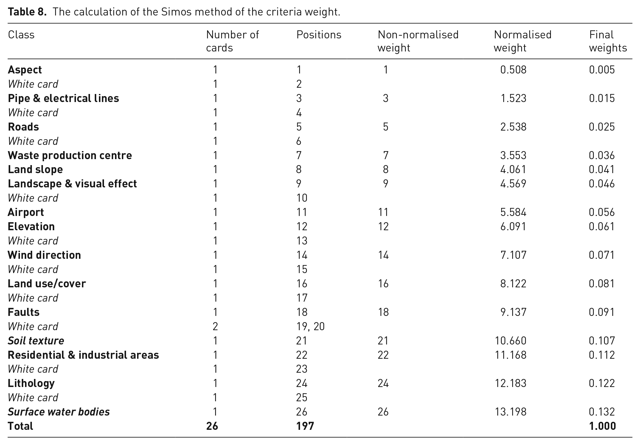
The method classifies the selected criteria into successive classes according to their importance. Initially, the criterion considered the least important is classified, then the next criterion, and so on until all criteria cards are used. The decision-maker can place one or more white cards between the criteria cards to increase the distance between successive criteria classes.
The Simos method was used to measure the weight assessment of the 15 selected criteria. The values indicated in Table 7 were evaluated by experts, and the importance level of the criteria and white cards to be used among the criteria were determined as the most appropriate values for this study. The corresponding analyses and detailed calculations of the criteria weights are presented in Table 8. Among the criteria, one or no white card was usually used, whereas two white cards were only used between faults and soil texture.
The concept of the method is the classification of the selected criteria in successive classes according to their importance. Initially, criteria coefficients are sorted from high to low value. According to the weight coefficients, environmental factors have higher importance than socio-economic factors. However, whereas surface water bodies and lithology, which are important for the protection and sustainability of surface and groundwater, have the highest level of importance, distance from residential and industrial areas affecting the quality of urban life, such as odour from landfills, health and noise from the operation, may have the highest importance level. Topographic criteria, such as elevation and slope, were found to have medium importance. Aspect, pipe and electrical lines, distance from the waste production centre and roads had the lowest weight coefficient, because these criteria affect the costs of the MSW landfill facility and the operation phase. In this case, previous studies and experts found them less important than environmental factors. Thus, the higher weight criteria are dominant criteria for site selection, whereas the lower weight criteria are non-dominant criteria. (Figure 5).
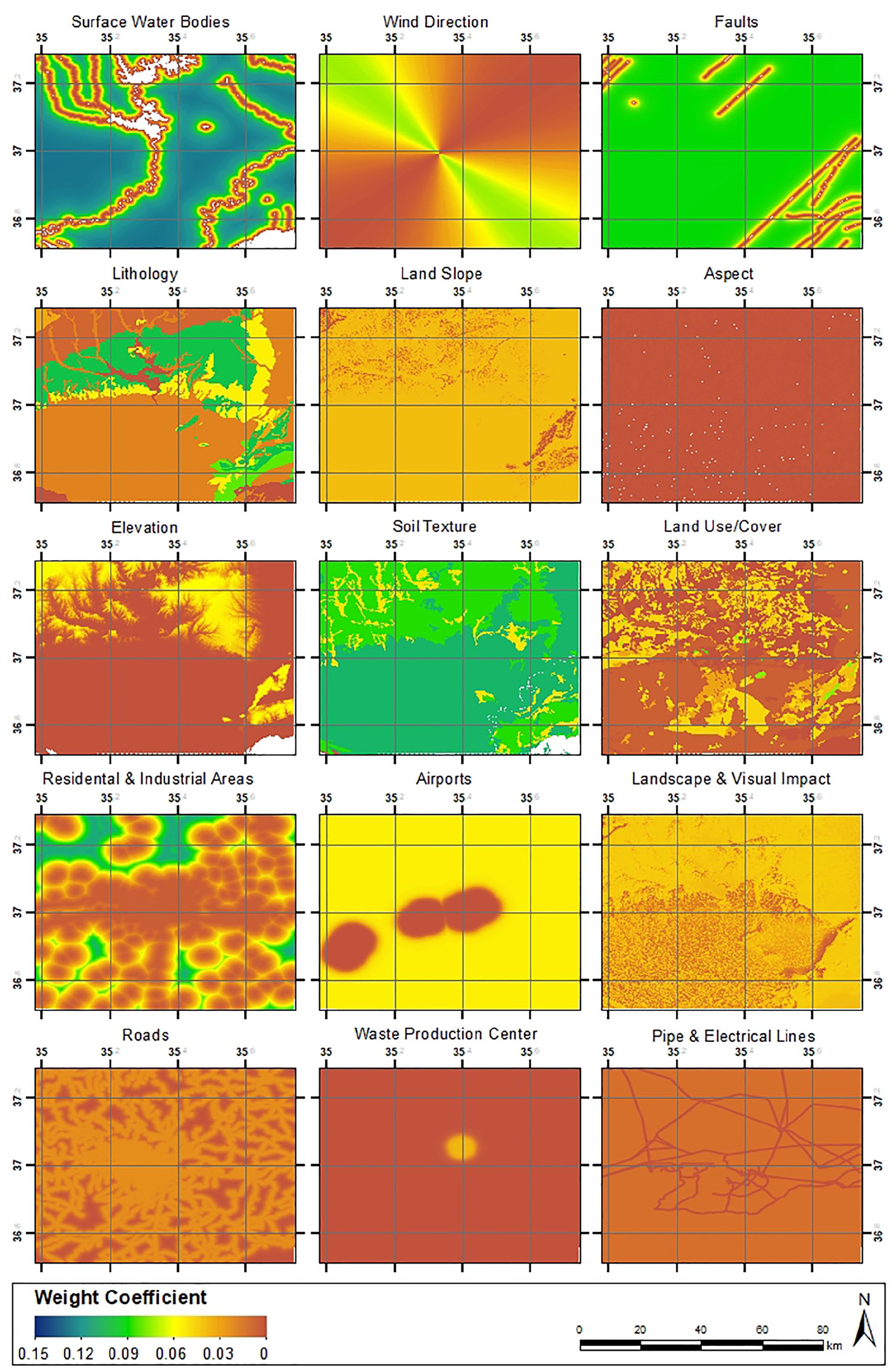
Maps of criteria with weight coefficient of the Simos method.
The MSW suitability map was produced by using overlapping analysis in the GIS by multiplying the weight coefficient maps. The suitability values were calculated as being between 0.25 and 0.85 for the study area. The integration of GIS features and a GIS-based multi-criteria approach involves the use of spatial data and relative weighted criteria to produce more valuable spatial data for critical decision making. In this study, MSW suitability was analysed to emphasise the importance of weighting criteria. Thus, the MSW suitability map was produced by assuming each criterion to be equally weighted. According to the results, when the criteria are used without weight, they will be misinterpreted in most areas. When the weighted method is applied, surface water bodies, residential and industrial areas and soil texture are weighted the highest, so are more important in the map. Pipe and electrical lines criteria should have little effect on MSW selection, but when weighting is not performed, they appear to play a dominant role in the results map (Figure 6).
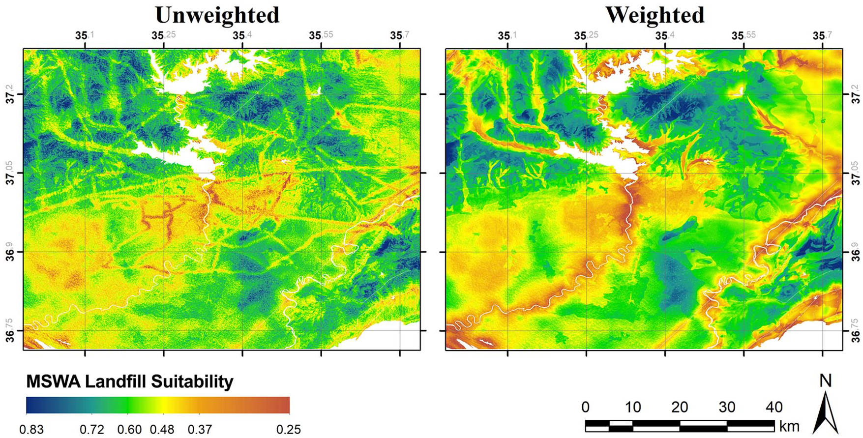
Comparison of municipal solid waste (MSW) suitability analysis using the unweighted and weighted criteria methods.
MSW landfill site selection is important because these areas affect urban life quality, the environment and landfill construction costs. After the MSW suitability map was developed through MCA and the Simos method, four different site options with the highest scores were selected. The final suitability results were divided into four discrete categories from low to very high suitability, that is, 0–25 (low suitability), 25–50 (moderate suitability), 50–75 (high suitability) and 75–100 (very high suitability), as shown in Figure 7. The suitability classes for the study area were calculated as 1% very high, 76% high, 17% moderate and 6% low suitability. Four different areas with high suitability class were identified and evaluated using a SWOT analysis.
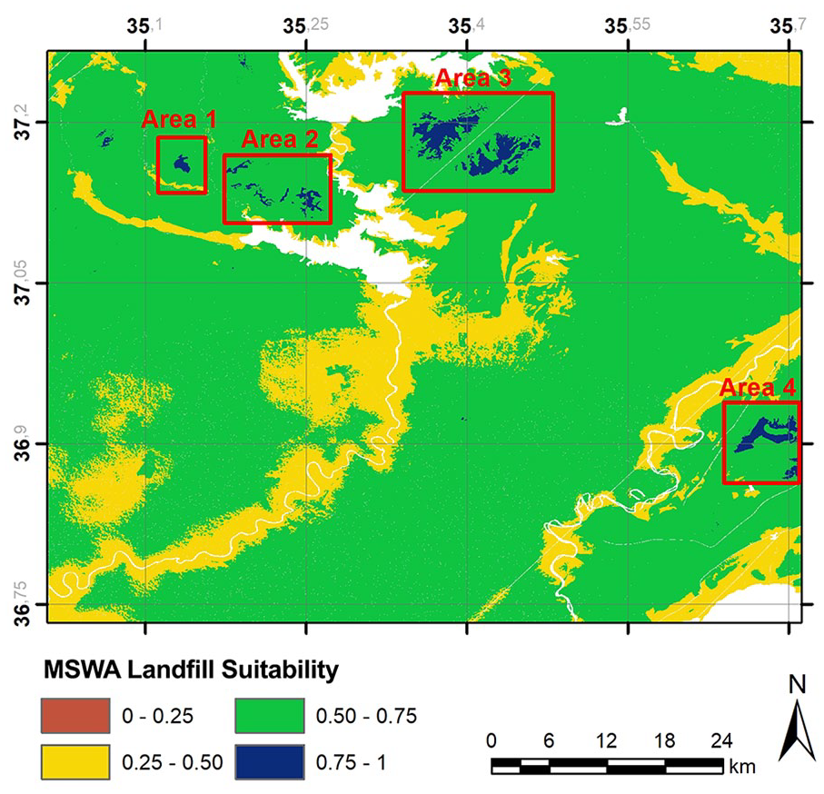
Suitable areas for municipal solid waste (MSW) landfill.
According to the results, the suitability scores of the four alternative areas were calculated as 0.76 for areas 1–3 and 0.77 for area 4. We were unable to sort these areas due to the absence of significant quantitative differences between suitability scores. Thus, SWOT analyses were used to evaluate the SWOT of each area for detailed investigations of the four options to determine the suitability of each of the alternative sites for future planning (Table 9). Depending on the scope of each programme, project and development and management plan, decisions-makers more effectively address problems that are likely to occur and search for methods for converting threats into opportunities and off-setting weaknesses against strengths.
Strengths, weaknesses, opportunities and threats analysis for alternative municipal solid waste (MSW) landfill sites.
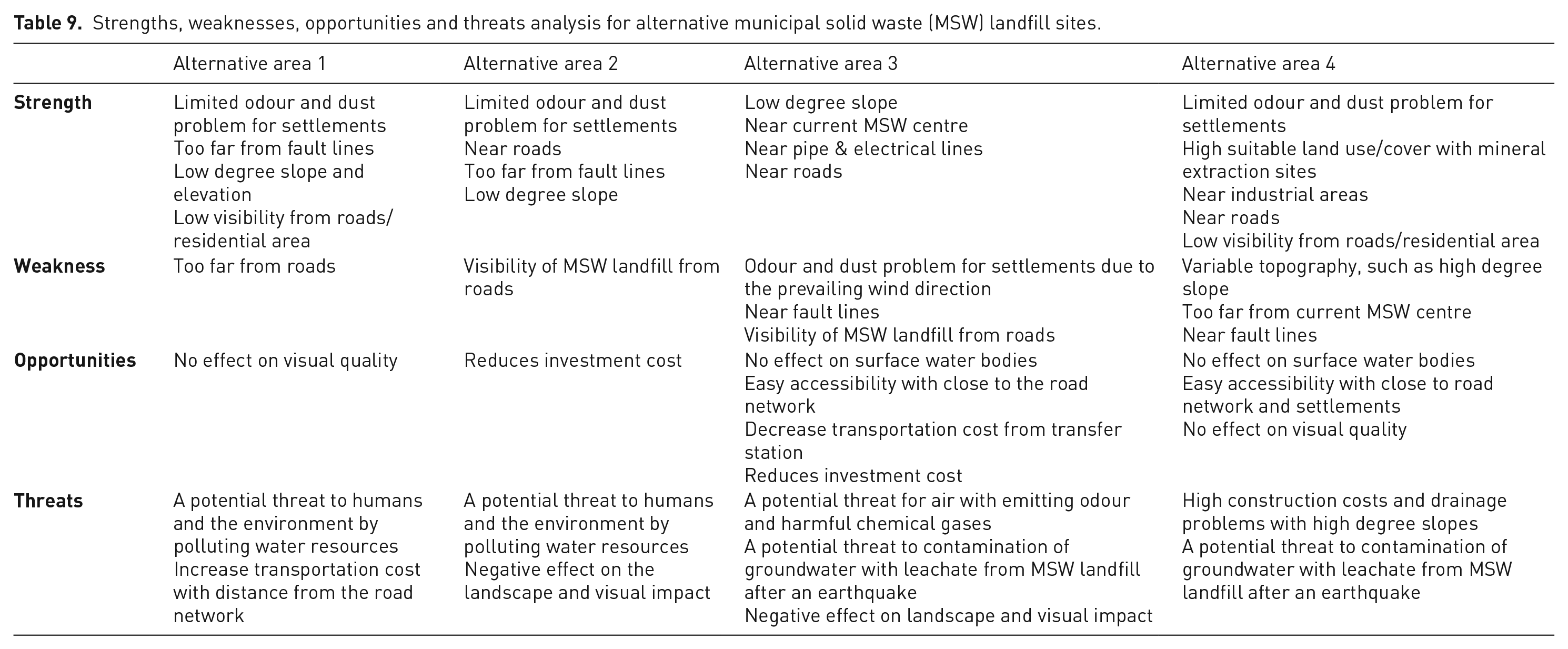
Important points to be considered in the decision of location selection should be as follows: (1) environmental protection of water resources, sensitive ecosystems, wildlife habitat, land degradation, etc.; (2) minimising the negative impact on urban life quality, such as odour, dust, low visual quality, etc.; and (3) financial considerations, such as proximity to roads, slope and transportation cost, which affect investment and construction costs.
Conclusions
The increasing generation of MSW in Adana, Turkey, is a challenge faced by governmental authorities because the existing MSW disposal area remains within the residential area, negatively affects the environment and urban life and is insufficient due to rapid population growth. The existing MSW disposal site is not a suitable location according to the final map. To avoid these problems with the new solid waste facility, selecting the appropriate location for the solid waste treatment facility is crucial.
MSW management involves complex decision-making situations that require the understanding of different factors, including environmental, technical, urban life quality, public health and social life factors. Various studies examined this complex problem and various techniques have been used, such as PROMETHEE, ELECTRE, TOPSIS, Simos and other multi-criteria decision-making techniques to rank the alternatives. In this study, the fuzzy logic and Simos techniques were used to evaluate and rank the most suitable alternative MSW landfill sites. The usage of fuzzy sets to describe uncertainties in different factors simplifies the complex structure of the decision phase. Using linguistic preferences can be useful for uncertain situations. During the selection of the landfill location criteria, political and financial/economic constraints, such as investment cost and area size, are not considered; however, environmental and socio-economic factors were included in the computation process, including 15 criteria categorised into two factors. The coefficient weighted criteria were derived from the literature and experts. The choice of the fuzzy membership function control points, at which set membership becomes either 0 or 1, was a critical issue in the factor standardisation process. The physical meaning of each variable must be considered before choosing the inflection points of the fuzzy membership function. As a result of the study, the result map was obtained by overlapping the maps created for all criteria, and four location options were determined for the construction of a MSW landfill site. Thus, the results can guide municipality authorisation to choose the best solid waste site among the alternatives.
The results here will help with selecting the optimal location for the construction of a MSW landfill, because many national and international studies were combined in the determination, evaluation and weighting of the criteria. This ensures that the methodology here can be applied to single regions as well as to different regions for a more realistic approach to justify why particular sites are chosen.