
Abstract
Precipitation in the Himalayas is vital in sustaining the region’s ecological and economic systems. Rainfall in river valleys supports agriculture, which is crucial for the livelihoods of both upstream and downstream populations. Snowfall at high altitudes contributes to glacier mass balance, ensuring the long-term availability of freshwater. It also affects water resources essential for drinking, irrigation, and hydroelectric projects in the mountainous and foothill regions. In the present study, using Himalayan cedar tree-ring samples 403 years long, extending back to
INTRODUCTION
The Himalayan region, often referred to as the ‘Third Pole’, is a crucial ecological and environmental zone, holding freshwater reserves comparable to those in the polar regions. The Himalaya, known as the ‘Water Tower of Asia’, provides water to nearly 1.65 billion people through major river systems and tributaries. These rivers are essential for agriculture, energy production, and biodiversity across South and Southeast Asia (Immerzeel et al., 2010; Yao et al., 2012). The region’s interconnected cryosphere, hydrological, and ecological systems sustain local livelihoods. However, climate change is increasingly disrupting these natural processes, threatening water resources, ecosystems, and the nearby communities (Sati, 2020).
India is the second-largest producer of agricultural products in the world (Pandey, 2019), where agriculture contributed to more than 18% of the country’s Gross Value Added (GVA) in 2020–2021 (GOI, 2022). Being a large exporter of agricultural products to the world, the Press Information Bureau of India, 2021 reported that in the fiscal year 2020–2021, India’s agricultural exports (excluding marine and plantation products) amounted to US$29.81 billion, reflecting a 28.36% increase from US$23.23 billion in 2019–2020. Agriculture productivity is directly influenced by regional weather and climate; therefore, weather and climate patterns directly impact the region’s agricultural productivity. According to the World Meteorological Organization (WMO, 2021), since the pre-industrial era, global mean surface temperature has increased by 1.2 ± 0.1°C, and the year 2020 was one of the three warmest years on record despite developing La Niña cooling conditions. An overview of crop yield studies shows that global warming has decreased wheat yield by 5.2% from 1981 to 2009 in India (Gupta et al., 2017). Incessant global warming and climate change have brought a direct impact on crop production, food supplies as well as market prices, imposing a grave danger to food security and adversely affecting the livelihood of millions of people in South Asian countries (Aryal et al., 2019; Bandara & Cai, 2014; Schmidhuber & Tubiello, 2007; Shankar et al., 2015; Wang et al., 2017).
Agriculture in the western Himalayan region largely depends upon winter and early spring precipitation. It has been observed that the Westerlies contribute ~40%–45% of annual precipitation. It is essential for cereal production (wheat, barley, etc.) and glacial mass balance, which provides fresh water to millions of people during the dry months of May-June (Alford et al., 2010; Immerzeel et al., 2010; Rees & Collins, 2006). Low precipitation leads to crop failure, resulting in food shortages. Additionally, reduced river flow during dry seasons causes water scarcity for drinking, irrigation, and industrial use. A notable decline in surface water flow in the Beas River at Manali during 1969–2004, and in the Parvati River at Aut in Kullu district during 1968–2004 has been recorded (Rana et al., 2014). Similarly, the Sutlej River at Songtong in Kinnaur district exhibited reduced water discharge during the winter season from 1993 to 2006. A comparable trend was observed in the annual water inflow of the Sutlej River at Bhakra Dam during 1984–2004, which has steadily declined over time (Rana et al., 2014). These findings underscore the long-term impacts of climate change on water resources in the mountainous regions of Himachal Pradesh over the past three decades. Furthermore, Glacier retreat increases the risk of Glacial Lake Outburst Floods (GLOFs), triggering flash floods that severely impact the livelihoods of local communities. A prominent instance of a devastating flood in the Himalayan region was occurred in Chamoli district of Uttarakhand, India, in 2021. A sudden flash flood swept through the Rishiganga, Dhauliganga, and Alaknanda River valleys on 7 February 2021, causing extensive regional destruction (Khanduri, 2022).
The available data on crop production, river discharge, and glacier mass balance from the past few decades are insufficient to understand variability and predict future trends. In this context, high-resolution tree-ring records serve as a reliable proxy for analysing and assessing changes in crop production (Maurya et al., 2023; Misra et al., 2021; Yadav et al., 2015) and river flow in the region (Singh & Yadav, 2012).
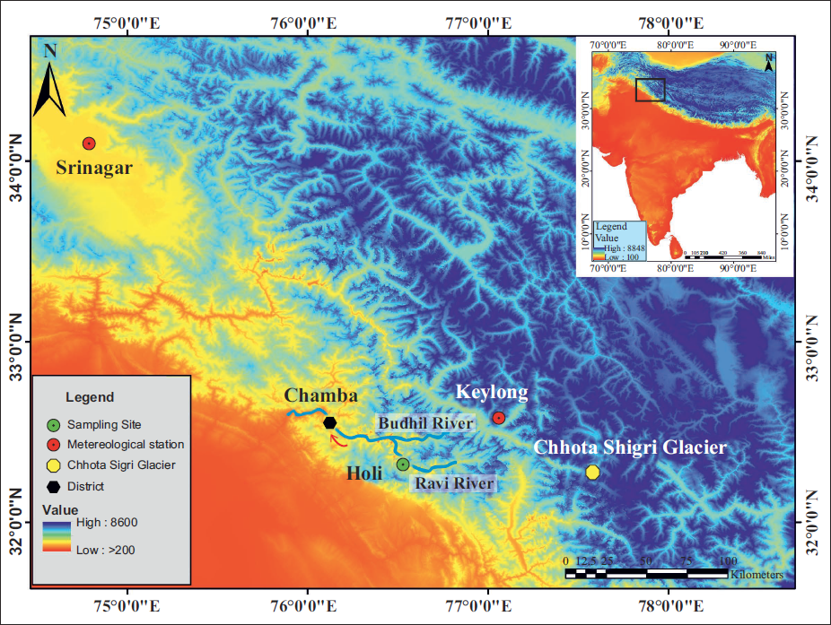
STUDY AREA
Annually resolved and precisely dated tree-ring chronologies allow reconstruction of past climate beyond the limit of instrumental records and thus help to understand climatic changes. In India, many tree species growing in sub-tropical to temperate regions have datable annual growth rings (Gamble, 1902). The tree rings of various conifer taxa from the different localities of the Himalayan region have been studied with long-term climatic variability back to the medieval warm period (Yadav et al., 2011). In the present study, the Himalayan cedar (Cedrus deodara (Roxb.) G. Don) tree-ring samples were collected from the moderate slope site of Holi, Chamba, Himachal Pradesh (Figure 1). Himalayan cedar generally grows at an altitudinal range from 1200 to 3300 masl of sub-tropical to temperate climate, where winter snowfall provides a favourable condition for its growth (Champion & Seth, 1968; Raizada & Sahni, 1960). Krummholz’s nature, with thick lateral branches and an umbrella-shaped crown, is the general characteristic of old Himalayan cedar trees (Misra & Misra, 2013). The species often suffer from wood rotting in humid sites, which limits the extraction of long increment cores to retrieve the maximum age of the trees. However, Himalayan cedar trees at drier sites have the potential to attain an age of up to a millennium and even more (Singh et al., 2004). Chamba is primarily a hilly district of Himachal Pradesh, extended between latitude 32°33’ N and longitude 76°07’ E. Topographically, the region is rugged with high mountains and deeply dissected by Ravi River and its tributaries. From the geographical point of view, the Chamba is in the Higher Himalayan region and experiences great diversity in the climatic conditions from sub-tropical to sub-alpine under varying altitudinal ranges from 600 masl to 6400 masl. The area experiences annual precipitation of ~2213 mm, mainly during the winter to spring season due to western disturbances.
MATERIAL AND METHODS
Tree-ring data
A comprehensive survey of the area was conducted to collect the tree-ring samples from healthy and old Himalayan cedar trees. A total of 35 samples were collected from 25 isolated and undisturbed trees without any visible marks of injury or fire, and efforts were made to extract the maximum number of rings up to the pith at breast height (~1.4 m) of the stem in the direction perpendicular to the natural slope. The openness of the forest ensures that the trees are free from the stand dynamics effect and have a maximum chance of retaining climate signals. In the laboratory, air-dried increment cores of Himalayan cedar were fixed in the wooden biddings with the transverse surface exposed. All the 35 tree-ring samples were polished with different grades of abrasive articles (220 and 400 grit) to make the cellular details of the growth ring discernible under the binocular microscope. The growth-ring sequences of the samples were plotted on the graph strips using the Skelton Plot method (Stokes & Smiley, 1968). The ring-width pattern of each sample has been compared using the cross-dating technique to assign the exact calendar years. The ring-width of precisely dated tree-ring samples was measured at 0.01 mm resolution using the LINTAB measuring system (Rinntech, Germany) coupled with a personal computer and binocular microscope (Rinn, 1966). Good consistency in the growth pattern of trees has been revealed in COFECHA (Holmes, 1983) analysis (mean r = 0.72) and in TSAP (Rinn, 1996), where year-to-year similarities in the ring-width patterns were noticed. Statistical software ARSTAN has been used for standardization to remove age and growth disturbance-related trends. The raw ring-width series has been detrended using cubic smoothing spline with the 50% frequency response cut-off equal to 2/3rd of the series length (Cook, 1985; Cook & Peters, 1981; Fritts, 1976). By calculating biweight robust mean (Cook, 1985), the individual tree-ring series were combined to develop a mean chronology. The standard version of the ring-width chronology spanning from
Himalayan cedar (Cedrus deodara) ring-width chronology (ad 1615–2017), along with the number of tree-ring samples used in chronology preparation, and the dotted line indicates expressed population signal (EPS).
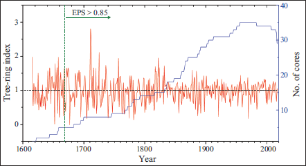
Himalayan cedar tree ring chronology statistics developed from Holi, Chamba, Himachal Pradesh (ad 1615–2017).
Climatic signal in tree-ring chronology
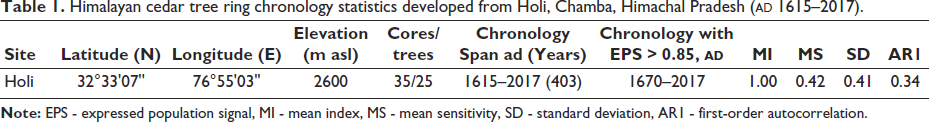
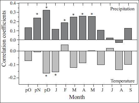
To understand the climate signal in mean ring-width chronology, response function analysis between tree-ring indices and monthly meteorological data (precipitation and temperature) was performed. For this, precipitation data of Keylong (32° 57’ N, 77° 03’ E; 3080 masl; 1903–1999) and temperature data of Srinagar (34° 08’ N, 74° 79’ E; 1585 masl; 1893–2003) were used (Figure 3). The reasons behind selecting these meteorological stations for the study are the similar climatic regimes over the sampling site and the unavailability of close meteorological stations. The bootstrap correlation was calculated using the program Dendroclim 2004 (Biondi & Waikul, 2004) for the respective standard period (i.e., 1903–1999) using monthly climate data from the previous year, October, to the current year, September (Figure 4). Bootstrap correlation analysis indicates that precipitation, except for August, directly correlates with tree growth. However, the relationship is significant for the previous year’s November, December, and the current year’s February to May. Mean monthly temperature showed a negative relationship with all the months except the current year’s February, March and July. However, December and January of the previous year have had significant adverse effects on tree growth, which revealed that increased temperature during these months reduces tree growth. Overall response function analysis showed that the cool and moist climatic conditions favour the tree growth, and increasing evapotranspiration during the summer hamper the growth of Himalayan cedar trees.
Mean monthly precipitation variation of Keylong, Himachal Pradesh, and temperature of Srinagar, Jammu and Kashmir, the meteorological station used in the present study.
Bootstrap correlation analysis between residual ring-width chronology and monthly climate variables (precipitation and temperature). The asterisk shows a confidence level of 95%.
RESULT AND DISCUSSION
Potential of Himalayan cedar tree rings in analysing crop production
Wheat (Triticum aestivum) and barley (Hordeum vulgare) are two major cereal crops belonging to the family Poaceae and order Poales. These two important crops are widely cultivated cereals, spread from 57◦ N to 47◦ S latitude over the globe. Wheat is produced and consumed as a staple source of nutrients for around 40% of the world’s population, although barley is mainly used for cattle feed and brewing (Giraldo et al., 2019). Agriculture over the Chamba region is arduous due to complex orography, absence of a proper network of canals for irrigation (only 5.2 thousand hectares is the net irrigated area), with steep, rocky and pebbly terraced farms that do not permit the mechanisation of farming activity. Due to the paucity of cultivable area (only 45.3 thousand hectares from total 692.4 thousand hectares of geographical area), farmers used most of the fertile land for wheat farming (21.3 thousand hectares in the year 2006–2007) and the infertile rocky land for barley farming (3.1 thousand hectares in the year 2006–2007) (District Agriculture Plan: Chamba, 2013). However, the productivity per hectare of wheat and barley is almost similar yearly because barley is a drought-hardy crop that can grow in infertile land and thrive in high-temperature conditions.
In the Chamba Himalayan region, Rabi crops are sown in April-May and harvested in September-October. Chamba’s wheat and barley production data were obtained with courtesy from the Agriculture Department of Himachal Pradesh to understand crop productivity. The annual production records of wheat and barley extended from 1970 to 2014. The scanty rainfall conditions since the 1980s to post-1990 have caused low rabi crop productivity in the area (Chandel & Brar, 2013). 1984 and 1985 are the two most affected years, with wheat productivity of 751 kg/ha and 885 kg/ha, and barley productivity of 704 kg/ha and 804 kg/ha, respectively. Crop failure during 1998–2001 results from the ENSO (La Niña) cold phase, and unusually warm ocean waters in the western Pacific region have contributed to the severe drought over southwest central Asia (Barlow et al., 2002). Dry phase during the 1990s, based on the area affected per year by drought, Himachal Pradesh (23.7%) was the third most affected state after Saurashtra & Kutch (37.5%) and East Rajasthan (29%), however, within Himachal Pradesh; Chamba was the most severely affected district (Guhathakurta, 2003) showing a heavy loss in crop production. Drought-like conditions due to deficient rainfall during the years 2004, 2007 and 2009 caused heavy damage to the rabi crop, apple and vegetable productivity, as reported from Chamba and other regions of the state.
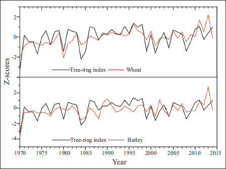
Wheat and barley productivity for 1970–2014 ranged from 689 to 2691.65 kg/ha and 764 to 2159.78 kg/ha, respectively. The correlation between the wheat and barley crop production data is 0.72. Pearson correlations among the tree-ring index and crop production data for 1970–2014 were positive. Wheat and barley productivity with the tree-ring index showed 0.50 (p = 0.0025, 1970–2014) and 0.62 (p = 0.0001, 1970–2014) correlations, respectively (Figure 5). Such a good consistency between ring-width chronology and crop productivity provides the strength to assess crop productivity using tree rings.
Comparison between ring-width chronology and wheat-barley productivity from 1970 to 2014 from Chamba, Himachal Pradesh, is plotted together; the data were normalised with respect to mean and standard deviation for the period (1970–2014).
The Rabi crop productivity of Chamba showed a positive correlation with the crop productivity of Lahaul-Spiti (Misra et al., 2021), Himachal Pradesh, and Kumaun, Uttarakhand (Yadav et al., 2015). The correlation between Chamba and Lahaul-Spiti, with wheat and barley crop productivity, is 0.39 and 0.71, respectively. The barley crop productivity correlation between Chamba and the Lahul-Spiti region is much higher than that of wheat because barley is a drought-hardy crop that can thrive in harsh conditions. However, the Chamba barley productivity significantly correlates with the Kumaun at 0.52 than wheat productivity. The reason for the better correlation between Lahaul-Spiti productivity and the amount of precipitation received by both regions is that Lahaul-Spiti and Chamba receive most of the precipitation in the form of snowfall in the winter and spring seasons due to westerlies. Snow-melt moisture, trapped within soil during spring, plays a significant role in crop growth. On the other hand, Kumaun comes under the Indian summer monsoon (ISM) dominated region, receiving most precipitation in the summer months. The precipitation pattern over Chamba and Lahaul-Spiti regions is somewhat similar, revealing a good correlation between the crop production of both regions. The significant relationship between the Himalayan cedar chronology and crop productivity showed that the moisture-responsive tree-ring chronologies could assess agro-climatic conditions over the high-altitude Himalayan region.
Potential of Himalayan cedar tree rings in analysing river discharge
As a key factor influencing river flow, climate encompasses both long-term moisture availability and short-term weather variations that determine the timing and volume of water reaching the drainage basins. Long-term river discharge data is crucial in assessing climate change effects, managing water resources efficiently, and mitigating natural disasters. It helps track patterns in precipitation, glacial melt, and temperature shifts, which are key for forecasting droughts and floods (Depetris, 2021). However, river discharge data are scarce in the Himalayan region and restricted to only a few decades. In this case, tree rings proved their potential to understand the river discharge variability from a long-term perspective in the western Himalayas (Misra, 2010; Misra et al., 2015; Misra & Yadav, 2007; Rao et al., 2018; Shah et al., 2013; Singh & Yadav, 2013).
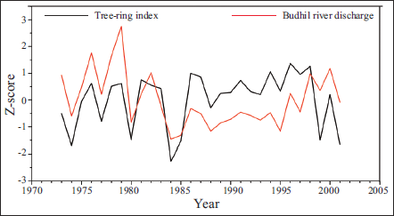
The Budhil River, a key tributary of the Ravi River, flows through the Chamba district in Himachal Pradesh. It originates in the Lahaul range at an altitude of 4,080 meters. It is nourished by glaciers from Manimahesh Kailash Peak and Manimahesh Lake, both of which hold religious significance, and it traverses rugged mountainous terrain before merging with the Ravi River near Kharamukh. To understand the potential of tree-ring analysis in evaluating river discharge, tree-ring chronology was compared with the available Budhil River discharge data for 1973–2001 (Bharmour Hydro Electric Project), which shows a correlation of r = 0.33. Several years of low and high discharge, such as 1974, 1977, 1980, 1984, 1985 and 1995 (low discharge) and 1976, 1979, 1982, 1998 and 2000 (high discharge), show consistency with the tree-ring data (Figure 6). This assessment highlights the potential of tree rings in understanding long-term hydroclimatic fluctuations in the region.
Comparison between ring-width chronology and Budhil River discharge (November–May) from 1973 to 2001 from Chamba, Himachal Pradesh, is plotted together; the data were normalised with respect to mean and standard deviation for the period (1973–2001).
Potential of Himalayan cedar tree rings in analysing glacial variability
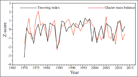
Tree rings are recognised as a valuable and sensitive proxy for reconstructing past glacier variability. Glacier mass balance, which reflects the net gain or loss of ice mass, directly indicates climatic influences on glacier behaviour (Azam & Srivastava, 2020; Hagg et al., 2004; Liu et al., 2020). In the Himalayan region, few studies have been conducted using tree ring proxies to understand the glacial behaviour (Bhattacharya et al., 2001; Rastogi et al., 2023; Shekhar et al., 2017; Singh et al., 2020). In this context, to evaluate the potential of tree-ring data from Chamba, Himalayan cedar ring-width data was compared with the available glacier mass balance data (modelled) of the Chhota Shigri Glacier (Azam et al., 2018) from the Lahaul-Spiti region of Himachal Pradesh. A significant correlation (r = 0.57) has been observed between the tree-ring chronology and glacier mass balance data from 1970 to 2013 (Figure 7). This comparison reflects several negative mass balance years, such as 1970, 1973, 1974, 1980, 1984, 1985, 2001 and 2012, as well as positive mass balance years, such as 1976, 1983, 1998, 2005, 2010 and 2011, which show consistency with the growth patterns of tree rings for the analysed period. This comparison reinforces the potential of Chamba’s Himalayan cedar tree ring chronology in understanding long-term glacier-climate interactions in the western Himalaya.
Comparison between ring-width chronology and Chhota Shigri Glacier mass balance (Modelled) data from 1973 to 2013 is plotted together; the data were normalised with respect to mean and standard deviation for the period (1973–2013) (Azam et al., 2018).
CONCLUSIONS
The present study reveals the significant potential of Himalayan cedar tree-ring chronology in evaluating past agroclimatic, hydroclimatic and glacial conditions in the Chamba region of the western Himalaya. The 403-year-long tree-ring chronology, developed from a moisture-stressed site, reveals a strong relationship with precipitation and an inverse correlation with temperature. Particularly, precipitation during the previous year’s winter and the current year’s pre-monsoon months plays a crucial role in tree growth. The study establishes a significant connection between tree-ring indices, crop productivity, river discharge, and glacier mass balance from Chamba, Himachal Pradesh. The positive correlation with Rabi crop yields, particularly wheat (r = 0.50) and barley (r = 0.62), for the period 1970–2014, underscores the relevance of tree-ring data in long-term agricultural production analysis. Furthermore, the association with Budhil River discharge (r = 0.33, 1973–2001) and Chhota Shigri Glacier mass balance (r = 0.57, 1970–2013) highlights the utility of tree-ring records in understanding long-term hydrological and glacial dynamics. These findings underpin the potential of Himalayan cedar tree ring data as a valuable proxy for assessing past agro-climatic trends and water resource variability from the Chamba, western Himalayan region.
Footnotes
Acknowledgements
We sincerely acknowledge Professor M. G. Thakkar, Director, Birbal Sahni Institute of Palaeosciences, Lucknow, for providing all the necessary facilities, support, and permission to publish the work (BSIP/RDCC No. 13/2025-26). We also thank the Forest Department, Government of Himachal Pradesh, for all necessary help and logistic support during the collection of tree-ring samples and the India Meteorological Department, Pune, for providing climate data. KGM thanks Prof. Mukund Sharma, Chief Editor, for inviting to contribute an article for this special volume to mark the Platinum Jubilee of the Palaeontological Society of India. We thanks both the reviewers for their valuable suggestions and comments.
Declaration of Conflicting Interests
The authors declared no potential conflicts of interest with respect to the research, authorship and/or publication of this article.
Funding
The authors disclosed receipt of the following financial support for the research, authorship and/or publication of this article: This work is supported by the DST-BSIP, Lucknow and ANRF-sponsored Project SCP/2022/000706.