
Abstract
Physical habitat and hydromorphological processes are fundamental to river ecosystem functioning and essential for restoring rivers subjected to multiple stressors. Extensive loss and damage to river and floodplain habitats caused by centuries of industrial, agricultural and urban development are preventing many rivers from achieving good ecological status even in places where water quality has improved. Restoration of river health and long-term resilience cannot be achieved without the foundation of good hydromorphological condition. Despite this, assessment of river health continues to be dominated by water quality monitoring. This imbalance has been exacerbated by increased public anger about serious pollution incidents, prompting an upsurge in environmentalist democracy, often led by activists participating as ‘citizen scientists’ (CS) at a local scale. Compared to chemical and biological water quality monitoring, assessment of physical habitat and hydromorphological quality is difficult and complex and the legal basis for monitoring is weak, resulting in low public awareness. Moreover, hydromorphology is not widely promoted in education, and professional expertise is scarce. We consider how CS volunteers might contribute to survey and assessment of physical habitat, proposing credibility and fitness-for-purpose tests for this activity. Reliable field data collection and valid interpretation are dependent on purpose and end use, deployed through appropriate survey design, sampling strategy, training and quality control protocols. Flexibility in the level of technical competence required for different types of field survey, allows carefully focused CS participation, although substantial professional input is required to ensure scientific and legal credibility. We recognise the invaluable advocacy role that CS volunteers can provide in raising public awareness and habitat restoration work at local level. A technical forum to address methodological validity, harmonisation of sampling effort, compatibility of data platforms and uptake of results would provide scientific credibility and build trust between professional river scientists and volunteers necessary for the effective deployment and uptake of CS surveys. Managed interaction would help to maximise efforts to restore rivers to full health in the context of building resilience for humans and biota under future rapid environmental change.
Keywords
Introduction
A keystone of UK environmental policies for >50 years has been science: ‘the evidence base’ has become a normative policy term. The major environmental regulator in England, the Environment Agency, (EA) prides itself on its ‘scientific leadership, advice, foresight and evidence needed to inform decisions’ (EA, 2023: 5). Political ambition for healthy, resilient rivers remains strong, (25-year Environment Plan: HM Government, 2018, 2023), although the multi-billion-pound costs and decadal timescales of remedying past damage nationwide are stark reminders of the effort required. However, there is widespread agreement that ‘the current system of water and environmental regulation no longer delivers the outcomes that society expects and needs’ (SSWAN, 2025). In response to recommendations made by the Independent Commission on the water sector (https://www.gov.uk/government/publications/independent-water-commission-review-of-the-water-sector), Government now plans to restructure the institutional arrangements for water pollution control in England, to improve industry regulation and environmental investment for river quality (https://www.gov.uk/government/speeches/government-initial-response-to-independent-water-commission-final-report/).
Professional-level application of science across a range of disciplines is fundamental for the sustainable management of rivers. Monitoring how rivers and their wildlife respond to multiple stressors such as land use and climatic change, pollution, water abstraction and engineering work is essential for maximising best environmental outcomes through regulatory, policy and operational decision-making (Jones et al., 2023). Systematic broadscale and project-related monitoring both require a high level of confidence in data collection and interpretation, involving substantial technical, financial and professional staff investment to ensure replication and validity of results. Equally important is provision of appropriate IT platforms for data analysis and harmonised sharing and use of outputs. Increasingly, monitoring information can be derived remotely (e.g. telemetry, drones, and map-based databases), but field survey remains indispensable for ground-truth validation and data interpretation. It is also, with suitable quality assurance and control, amenable to contributions from citizen science (CS) volunteers ranging from amateur enthusiasts to retired ex-professional river scientists. Maintaining the scientific and legal credibility of field survey methods for physical river habitat assessment, whilst identifying the potential for CS involvement is the major focus for this paper and we conclude with recommendations on how that might happen. An important context is provided by differences in the strong legal, technical and public profile attributes of water quality assessment and weaker ones associated physical habitat assessment and its core science of hydromorphology. The general principles of scientific and legal credibility apply beyond the UK but we use examples from England to illustrate specific points.
Context: Why does water quality dominate river health assessment?
Main reasons for differences between water quality and physical habitat assessment of river health in England.
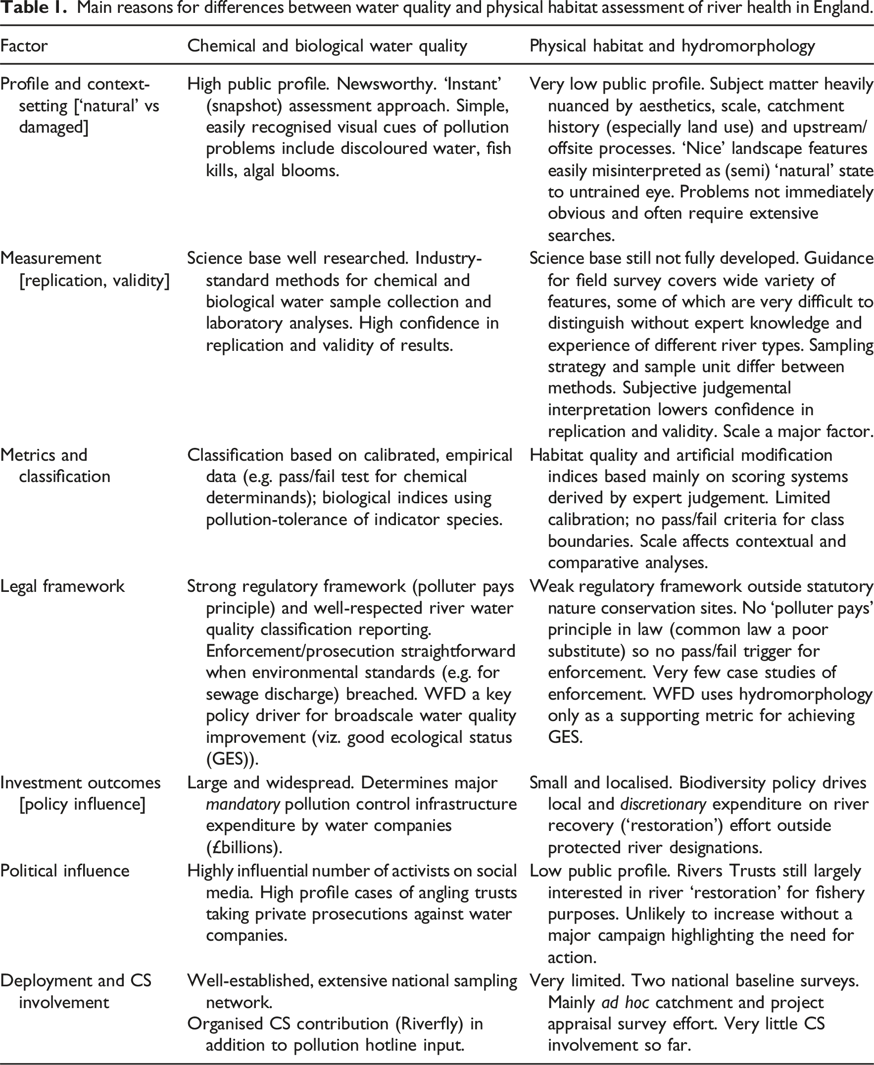
Vitally, chemical and biological water quality assessment of condition (e.g. trends in chronic conditions and the thresholds between contamination and pollution) and compliance (for regulating pollution and other harms) use calibrated, industry-standard methods. Both objectives require careful consideration of the relationship between ‘weight of evidence’ and ‘burden of proof’ because monitoring results can result in legal process. Importantly, courts and judges can determine what counts as evidence and whether the case concerns performance or compliance (Dicks et al., 2014; White et al., 2022). There is no equivalent industry-standard process to support legal enforcement or challenge associated with physical habitat assessment, resulting in a weak EA response to illegal channel reshaping and dredging (O’Brien, 2024).
Despite the strong legal requirements for water quality monitoring, substantial funding cuts in government support for research and river management institutions from about 2010 has severely reduced river monitoring effort, incident response and legal enforcement activity by the EA (Box 1). The consequence is that ‘getting a complete overview of the health of our rivers (our italics) and the pollution affecting them is hampered by outdated, underfunded and inadequate monitoring regimes’ (HoCEASC, 2022: 5). Many environmental monitoring systems are considered not fit-for-purpose (OEP, 2024a), and half the 44 targets for environmental improvement have ‘data deficiencies or need additional indicators to monitor progress sufficiently’ (OEP, 2023). As a result, the Water Framework Directive (WFD) objective of 77% of waterbodies achieving ‘good ecological status’ by 2027 is more likely to be 21% (OEP, 2024b).
Box 1. Impacts of funding cuts on EA activity
• DEFRA grants to the Environment Agency have fallen by 56% compared with 2009–2010. • Despite a rise in 2022/23 there remains a decline in real terms. • Enforcement action has declined by 84% between 2012 and 2022. • Prosecutions under the Agency’s regulatory powers fell from ca. 300 in 2012 to 20 in 2021. • Of 4074 enforcement actions taken against companies during the same decade 59% did not result in a fine. • In 2022, EA staff were instructed to ignore ‘low impact’ pollution incidents due to lack of capacity. • Water pollution monitoring has been reduced to such an extent that few pollutants are monitored and reported in ways that allow preventative action to be taken. • Context: The EA takes water samples for 42 different legislative contexts, >99,000 samples for 1800 determinands. Sources: Colbert (2022); Browne (2024); https://environmentagencyblog.gov.uk/2025/03/06.
The current public and political focus on the ‘water quality crisis’ in England deflects attention away from the importance of multiple stressors affecting river health, including disruption to fluvial morphological processes and consequent degradation of physical habitat and impoverished river ecosystems. Gumiero et al. (2025: 20) wisely conclude that: ‘Pressures and measures with easily identifiable sources often appear more manageable than hydromorphological pressures, which frequently stem from legacy issues or multiple stressors’. It is not surprising that a recent global literature review of CS contributions to river science by Shao and Bishop (2025) reveals a dominant water quality role.
There have been no broadscale national surveys of river habitats in England (and Wales) since 2007–2008 (Seager et al., 2012), following the first, UK wide, baseline survey in 1994–97 (Raven et al., 1998a). Financial constraints in the EA undoubtedly have been a factor, but for pragmatic reasons the interval between these snapshot overview surveys will depend on the pattern and rate of change expected and granularity of sampling in relation to the very low (albeit statistically valid) proportion of river network covered (ca. 2% at 1:625000 scale). More intensive sampling in catchments to characterise specific reaches, detect impacts of planned development and assess the effects of local river restoration work represent another form of monitoring, commissioned as specific project work. Nevertheless, further national surveys will be required to assess long-term broadscale trends in river habitat quality and modification.
The lure of citizen science: A ‘cheap’ policy response to a crisis?
Public anger about the poor state and perceived neglect of rivers has generated considerable local action and therefore propelled CS to the forefront of the policy arena, with Government actively encouraging statutory organisations to collaborate closely with local communities and voluntary groups to help monitor river health (environmentagency-blog.gov.uk/2025/03/18/citizen-science-and-the-environment-agency/). During 2022–2025 the water industry regulator (OFWAT) has funded a national project (CaSTCo: the Catchment Systems Thinking Cooperative), rolling out prescriptions for CS engagement and involvement in all aspects of river quality (https://castco.org). However, under such socio-political conditions (including scarcity of professional expertise) Lave (2012a) has highlighted the very real dangers of ‘extra-mural knowledge production’. Substituting or depleting the critical mass of professional-level science (in any discipline) in favour of CS undermines the credibility of policy level decision-making, particularly in relation to the veracity of expert opinion. However, as a well-directed adjunct to improve local knowledge, CS has substantial potential benefit.
Britain has a long tradition of competent (including professional level) amateur, that is, unpaid, specialists (Allen, 1994; Freeman et al., 2007). As Mulgan (2020: 149) points out, ‘Citizen science has already transformed the everyday work of astronomy and zoology, counting and mapping stars and animals’. He also refers to the contribution of the Zoe ‘symptoms’ project during the COVID-19 pandemic in the UK (https://zoe.com/learn/category/covid/covid-symptoms). Many argue for the National Health Service to make greater use of ‘Patient-Generated Data’ (University of Manchester, 2022) but investigations in the field of human health reveal some of the caveats we make below about CS and river health (Cresswell et al., 2018; West et al., 2017).
The flagship CS participation in river monitoring is the Anglers’ Riverfly Monitoring Initiative, in which trained volunteers can reliably assess water quality conditions using the relative abundance of macroinvertebrate taxa indicative of pollution stress. Brooks et al. (2019) take care to relate the strength of Riverfly indices of pollution to those used in law, citing 5 case studies where their use has brought about water quality improvement without using prosecution. The availability of reasonably priced, accurate monitoring equipment for some water quality parameters, together with ‘real-time’ mobile phone data collection and transmission, has allowed an upsurge in CS engagement. The speed and flexibility of CS volunteers in responding to pollution incidents often beats that of the depleted ranks of the EA; Roger et al. (2024) express this as, ‘being place-based, making it more logistically feasible to capture episodic events’ (p. 1).
At least 10 UK eNGOs currently motivate volunteers to monitor the state of rivers, either in ‘blitz’ sessions, in pollution episodes or as a routine commitment. A major focus for CS involvement in rivers is the network of 65 Rivers Trusts in Britain and Ireland. Collins et al. (2023) highlight the Trusts’ use of citizen science to ‘engage and empower’. However, they admit that ‘the dominant approach within freshwater citizen science lies disproportionately at the lowest level of participation’. The transfer of professional scientific knowledge and capacity from statutory to voluntary sector seemed to represent an ideal opportunity for filling some of the WFD monitoring gaps at low cost (Newson, 2011). This was one element of a deliberate policy to increase involvement of CS across a wide range of disciplines (Fraisl et al., 2022). But there are substantial consequences resulting from a decline in professional field survey expertise and the validity of ‘expert opinion’. In addition, there are considerable costs for training, support and ongoing maintenance of CS participation: CS is certainly not a cheap credible alternative to professional science.
Semantic precautions in a diverse field of public environmental engagement
CS terminology is important because ‘citizen science’ covers a range of competency levels variously labelled with vague confusing terms such as ‘community science’, ‘vernacular/indigenous science’, ‘local knowledge’ or ‘nature noticing’ and defined by purpose and reasons for participation (e.g. Pocock et al. (2023), Guston (2023: 92), Gumiero et al. (2025: 11); Yeung et al. (2024)). The European Citizen Science Association (ECSA) sets out 10 principles for ‘fostering excellence’ in CS (Robinson et al., 2018), while the European Cooperation in Science and Technology (COST) network makes a granular analysis of many components of CS (‘The Science of Citizen Science’: Vohland et al., 2021). Most helpfully, CaSTCO has defined several categories of CS competency (https://www.castco.org/knowledge-categories/purpose/).
Mulgan (2020) sees CS as short-circuiting the existing barriers between science and democracy. ‘Most of the people involved in citizen science observe a strong ethos, a belief in the redemptive power of science, particularly in relation to observation and interpretation’ (p. 150). In this way, ‘science can become a shared activity, something integral to democracy and citizenship’. CS can/should promote environmental activism and strong representation; both these purposes and the relevant socio-political processes (‘the mechanics of virtue’) are behind the failure of public participation in river basin planning under the WFD (Rimmert et al., 2020; Van der Heiden & ten Heuvelhof, 2012).
With the advent of a catchment-based approach and place-based solutions, for example, to create flood resilience (Newson and Lewin, 2024), the involvement of these various sources and acknowledgement of their appropriate role, strengths and weaknesses are important to resolve (Roger et al., 2024). It may well be that ‘the place’ is the best scale for integrating professional and CS contributions to survey and ‘monitoring’: clearly, sampling and data collection harmonisation, supported by compatible IT platforms will maximise use of CS survey information at the national scale.
The Rivers Trust (https://theriverstrust/news/citizen-science-10-ways-you-can-get-involved-in-the-fight-for-cleaner-rivers) publishes a guide to using CS ‘in the fight for cleaner rivers’. All feature water quality and wildlife, none assesses physical habitat; it is concerning that only one CaSTCo demonstrator catchment (https://castco.org) is deploying hydromorphological assessment – that of an estuary. More recently, Shuker et al. (2024) illustrate a CS level hydromorphological appraisal for local river restoration. A more formal strategic and management menu for CS involvement with freshwater issues is provided by Bishop et al. (2021), whilst the River Restoration Centre (RRC) has a comprehensive online resource guiding users to the features of all the available survey/assessment techniques, including physical habitat and hydromorphology (https://www.rrc.org/).
Generic guidance on the suitability, reliability and usefulness of CS involvement in a range of environmental and ecological monitoring programmes has been developed (e.g. Sutherland, 2022), and several reports (e.g. Pocock et al., 2014; Tweddle et al., 2012) set out standards and procedures, albeit without an agreed consensus on ‘rules’ that might define appropriate CS data quality. Indeed, concerns about the consequences of a headlong rush to embrace CS without proper scientific input to planning and deployment have begun to emerge (e.g. Bowler et al., 2024; Fraisl et al., 2022). Tweddle et al. (2012) arrest their readers with an opening section entitled, ‘Before you start. Is citizen science the best approach’? More recently, the EA has provided eight generic guidelines that temper unbridled enthusiasm with sensible precautionary tests in planning and deploying CS project work (environmentagency-blog.gov.uk/2025/03/18/citizen-science-and-the-environment-agency). The main challenge for well-targeted and properly managed CS is the capability to incorporate, (like ‘mainstream’ scientific research does currently), strategically significant data that provide incontrovertible evidence to detect problems and opportunities that support or change the direction of environmental policy, including managing rivers. As with all scientific endeavour, a rigorous approach is required to ‘weight of evidence’, within the peer group even before any legal aspects of ‘burden of proof’ are encountered (Gough, 2007); lawyers also use the term ‘evidential value’. Kucharski (2025) goes so far as to suggest that legal frameworks my provide the best ‘proof’ for all science results. This challenge is uniquely severe in the case of the quality of physical habitat, as incorporated in the WFD’s ‘hydromorphological quality’ category.
Principles for monitoring and assessment of physical habitat
Much of the damage done to rivers has been physical (Newson, 2022) and recovery requires restoration of morphological diversity, with associated benefits for habitat quantity and quality, together with resilience to climate change. Whilst there was protest at the damage (and practical guidance on how to rectify it) it was largely from academics and NGOs (Purseglove, 1988/2017; Lewis and Williams, 1984; Ward et al., 1994).
River science professionals (sensu Newson et al., 2023; Wohl et al., 2015), with very good reason, emphasise the special expertise required in the field of river hydromorphology despite the criticism that ‘a common mode of conducting citizen science is to have lay people act, in essence, as volunteer research labour on a project designed by elite scientists for their own goals’ Guston (2023: 94).
Professional survey and assessment of physical habitat quality of rivers in England developed from the late 1980s when annotated field maps identified features of conservation interest that needed to be retained during river engineering work (River Corridor Survey: NRA, 1992). In the mid-1990s, River Habitat Survey (RHS) was developed (Fox et al., 1998; Raven et al., 1998a), collecting RCS – type information in a systematic, pragmatic way to characterise and evaluate the diversity and modification of river habitats in Britain at a 500 m scale. It was designed to help meet the WFD (European Commission, 2000) requirement for assessing ‘hydromorphology’, a terminological amalgam describing the interaction of flow and channel form that is the basis of physical habitat (Newson and Large, 2006). The first ever state of environment report for river habitat quality in the UK was based on a stratified random sample of >4500 RHS sites surveyed during 1994–97 (Jeffers, 1998; Raven et al., 1998a).
The WFD elevated the importance of river habitat by including hydromorphology as a qualifying variable for assessing ecological status its core river health index. Hydromorphology both directly and indirectly impacts overall river ‘health’: directly via the ‘ecohydraulics’ (Maddock et al., 2013) created by flow-substrate interaction and indirectly through transporting/depositing coarse and fine sediments (and inter alia persistent pollutants), acting as part of the ‘multiple stressor’ dynamics. Describing and assessing this complicated and complex environment is difficult technically and the methodology is still evolving, not the least because research in geomorphology, hydrology and hydraulics operates separately in the academic world (Newson, 2002); efforts to bring an amalgamated ‘river science’ to education have been limited (Newson et al., 2023; Vaughan et al., 2009).
CS hydrology remains the poor relation of engagement and participation, partly because it has remained a sophisticated technical activity, vital enough to be in professional and institutional hands. However, Buytaert et al. (2014) point to the recent availability of ‘robust, cheap and low maintenance sensing equipment’ offering opportunities for citizen participation. These authors also stress the challenge to CS hydrologists to ensure ‘the generated data complement optimally other available knowledge’. Nardi et al. (2022) report on the work of the International Association of Hydrological Sciences to develop online resources to inform and train CS participants.
Damage to physical habitat is also widespread because of the control of river flow regimes for water supply, wastewater and flood protection (Petts, 1988). Flow-regulated rivers with large headwater reservoir impoundments are categorised under the WFD as ‘Heavily Modified Waterbodies’, with the management objective of achieving ‘Good Ecological Potential’: GEP (SNIFFER, 2006, 2012), the equivalent of mimicking natural flow as far as possible. Central to achieving GEP is an environmental flow regime (Acreman, 2016) for reservoir releases; flow characteristics form part of the ‘multiple stressors’ concept. Vezza et al. (2015) develop an Index of Habitat Stress Days, alongside an Index of Habitat Quantity to describe the impact of modified flows on the fish community. The nature of flow regimes means balancing the needs of river ecology, human interests, including flood protection, and the ability of reservoir valves to deliver. Because of the legal restrictions on reservoir operators to balance water stored in reservoirs with downstream flood risk, finding an ideal compromise for releases in flood-prone catchments can be difficult or impossible. Remedying the ‘hydro’ of hydromorphology is, therefore unsurprisingly, considered ‘too difficult’ to resolve. Hydrological science and data streams are also more difficult to access by citizen scientists than simple water quality; a potential exception is mapping hydraulic biotopes via ‘flow types’ (Newson and Newson, 2000) which forms part of RHS. Newson et al. (2002) combined field-mapped biotope frequency and diversity (near flow gauging stations) with flow exceedances and undermined the accepted Q95 protected environmental flows below dams and hydropower plants. Biotope mapping is appropriate to both professional and CS surveys.
‘Natural’ river form and process: A template for repairing physical damage?
A river obviously damaged by organic or toxic pollution offers immediate recognisable cues for deviation from clean-water state, although there are subtle natural forms of contamination. However, assessing deviation from ‘natural’ physical habitat is far more complex and the subject of technical debate. Natural state is defined by EU directives in terms of ‘reference condition’ or, in ecosystem protection, ‘favourable condition’. Whilst Directives relating to water and nature differ in their general approach to reference conditions (Mainstone, 2016), the common understanding is an unimpacted (or nearly unimpacted) state, equates to natural river function.
Inevitably, compromises and trade-offs have to be made in trying to simplify or categorise a very complex subject matter. Problems arise if surveyors are asked to judge the ‘naturalness’ of a particular site without using a full array of supporting information and cues, leading to unverified and often erroneous conclusions. That is why for scientific credibility, most professional surveys are predominantly data- and not opinion-driven; interpretation and associated categorisation are part of data analysis, not field assessment. This gives rise to a stark difference between surveys that characterise the physical form and habitats of channels and floodplains, followed by decisions about ‘what’s been altered’ (e.g. RHS), or purpose-built surveys of modifications and their impact (e.g. MIMAS). This dichotomy also applies to judgemental-based CS surveys, highlighting the pivotal role of professional input to surveyor training and especially data interpretation purposes. The latter is particularly important when distinguishing between morphological features caused by human interventions and those responding dynamically to fluvial consequences of rapid climate change.
In England today, it is virtually impossible to identify a ‘pristine’ river of any size outside remote headwaters (Raven et al., 1998b). Sear (2023) suggests that we have forgotten what a natural river looks like, whilst Moss (2015) asserts that disturbance is so widespread that freshwater reference states are in fact ‘anthromes’, not biomes. In a token acknowledgement of the virtually universal anthrome, the European Committee for Standardisation began its work on hydromorphology standards (CEN, 2020; see also BSI, 2004) by advocating ‘near natural’, with zero tolerance of obstructions like weirs but, arbitrarily, up to 5% (by length) of channel modified by, for example, bank structures. ‘Artificial bed materials’ are, however, limited to <1% by CEN (Boon et al., 2010). Scientific debates and dilemmas concerning reference conditions are explored by Johnson (2001), Johns et al. (2013) and Newson (2022); techniques used to define them vary from expert opinion to mathematical modelling – all having strengths and weaknesses. Szalkiewicz et al. (2020) promote the incorporating of local ecological knowledge to define both ‘natural’ and ‘damage’ prior to restoration design.
Johnson et al. (2020) propose a category of ‘working streams’: most research geomorphologists favour process as the definitive natural element of rivers because forms are locally controlled by the boundary conditions to those processes (Newson, 2002). In trying to counter the problems of scale, dynamic processes and naturalness in one simple survey technique, Rinaldi et al. (2013) devised the Morphological Quality Index; relevant expertise is still required for making competent qualitative judgements of departure from reference condition.
Natural England’s Priority Habitat surveys, deployed by the Freshwater Biological Association using CS volunteers uses ordinal scales of disturbance (i.e. departures) in flow, morphology, biology and chemistry to provide a rapid qualitative evaluation of rivers for the specific purpose of targeting statutory protection or restoration, focusing on smaller headwater streams (https://priorityhabitats.org). Trained CS volunteers make informed subjective decisions on a five-fold scale as to the physical, hydrological, chemical and biological naturalness of a georeferenced survey section, triggering professional follow-up action where needed.
For habitat damage to be indexed, departure from ‘natural’ conditions across an array of river types needs to be calibrated by survey, assessment and data processing systems. Walker et al. (2002), use habitat quality and modification scores (HQA, HMS) from RHS at a catchment scale to guide restoration priorities. Sear et al. (2010) use professional, expert Fluvial Audit to yield greater site detail for restoration decision support.
Hydromorphological factors within the panoply of multiple stressors
Science and the law seek ‘truth’ and both disciplines have strict rubrics about pathways to reach it. Given the range of legal implications possible for hydromorphological assessment and monitoring, both CS and professional evidence must therefore be ‘fit-for-purpose’. That purpose needs to reflect the topic (within, say, river monitoring) and the levels of detail, certainty and accountability scientists consider necessary for producing evidence acceptable as proof. The issue has been carefully addressed by the US Environmental Protection Agency (1996) in guiding CS workforces such as that of the Chesapeake Monitoring Cooperative (2020). It is also a feature of the CaSTCo project, where five tiers of ‘seriousness’ for hydromorphological assessment techniques (five of nine of which are CS) are used to assist project planning (https://www.castco.org/knowledge-base/overview-physical-habitats/).
There have been few comprehensive and critical international reviews of operational hydromorphological survey and assessment systems. Berletti et al. (2015) come close to making useful critical judgement with a tabulation of ‘strengths and weaknesses’. Overview papers attempt to set out the principles of a good physical habitat or hydromorphology survey, including appropriate spatial scaling. Retrospective QA/performance indices are virtually never performed: only ‘successes’ get published, despite reporting failures being equally important to ensure (as in medical science) the best investment of effort and resources.
In addition to the paper by Belletti et al. (2015) there is the more recent and policy-related work by Papangelakis et al. (2023a,b). Both reviews highlight the lack of direct process assessment or variables directed at uncovering morphological process. Papangelakis et al. advocate the need for flexible systems that allow surveys to match more closely with local conditions, project aims and requirement for detail. This was also a theme of the REFORM project (Gurnell et al., 2016; Rinaldi et al., 2013) which led to CS-focused MoRPh (Shuker et al., 2017) in the UK. REFORM was an important influence on moving the WFD away from simplistic ‘refcond’ (Mosselman et al., 2024). Assessing the suitability of a particular method requires clarity about overall purpose so that a deployment plan contains the appropriate sampling strategy, quality control protocols and technical support needed to ensure validity and uptake of outputs. This applies to hydromorphology in particular because of the complex difficulties involved in trying to characterise and measure suitable parameters that relate to the scale and processes associated with the river continuum. To extend and develop the work of Berletti et al. and Papengelakis et al. (and as our contribution to the CaSTCo project) we accessed full technical details, uptake and deployment literature for 26 hydromorphology survey and assessment methodologies. Our purpose was to reveal characteristics that would help user individuals or institutions select a methodology ‘off the shelf’ or develop one of their own. Particular attention was paid to variables qualifying the field survey/assessment for CS deployment or as a basis for collaborative use with professionals. Recommendations were eventually cast according to fitness for purpose (See Table 3).
The pedigree of RHS gives the system ‘fitness’ and it has fulfilled its main purpose of assessing the physical state of rivers nationally and assisting assessment of compliance with the EU WFD. The RHS national surveys of 1994–7 and 2007–8 suggested 62% of sites were obviously modified or significantly modified (Environment Agency, 2010). Of the prominent modifications to channel form, bank resectioning (43%) and reinforcement (8%) showed little change, implying no statistically detectable overall deterioration or habitat recovery in a decade (Seager et al., 2012). Indeed, the most profound change was the increase in invasive non-native plant species, notably Himalayan balsam (Impatiens gladulifera). A CS version (https://www.therrc.co.uk/cRHS/cRHSManual) has been deployed in Wales, linking directly to the full RHS dataset.
The independent advisor to Government on the implementation of environmental law, including the ‘retained EU law’ (the Water Framework Directive, until 2027) and has recently reported on progress made in England (OEP, 2024b) and the Government has responded (Defra, 2024). Separately, the Environment Agency and Natural England have reported on ‘Indicator B3: State of the Water Environment’, a feature of the 25-year Environment Plan (Gov. UK; 2024). Both reports reveal the state of hydromorphology and the physical modification of waterbodies (proxy reporting scales for the WFD). Indicator B3 shows that 58% of rivers and canals have hydromorphology capable of supporting Good Ecological Status (the indicator target for WFD), compared with 76% for aquatic macroinvertebrates, 43% for fish and 45% for macrophytes and phytobenthos.
The Government response to the OEP report (Defra, 2024) refers to ‘the challenge of physical modification of water bodies’ (p. 6), which ‘in some cases over centuries, severely disrupts natural ecological process’. Despite this ‘physical modification of water bodies is the primary pressure preventing good status’. OEP concluded that the current monitoring programme is inadequate and argues that ‘this has resulted from EA budget cuts in this area’. The European Environment Agency (2024) shows that the UK is not alone in failure to reach GES on schedule and many of the pressures are shared. 51% of EU waters do not reach ‘good’ hydromorphological condition.
We have deliberately made frequent references to water quality issues, not only because of their current prominence in CS development in England (an international phenomenon – see Shao and Bishop, 2025), and the lessons for scientific integration already emerging (such as CaSTCo) but because damaged freshwater habitats should be considered the result of multiple stressors and optimal remedial action should reflect this.
The concept of multiple stressors has vital implications for the deployment of both professional and CS in river survey and assessment. It gains momentum from the work by Whelan et al. (2022) who claim that at least seven new stressors undermine the assertion that water quality continues to improve. Awareness of new risks such as microplastics (Dent, 2023; Woodward et al., 2021) and pharmaceuticals (Wilkinson et al., 2022) implies that CS contribution based on the simplest chemical and biological indicators can at best raise awareness because these new compounds require sophisticated analytical laboratory equipment. Likewise, to avoid erroneous conclusions, field survey data validity is fundamental for confirming hydromorphological stress at site, reach or catchment scale. This constrains CS involvement to those with an advanced level of training and competence such as that required for MoRPh and cRHS.
Despite better understanding of multiple stressors the biological response remains debatable. Analyses of aquatic macroinvertebrate data against environmental variables by Jones et al. (2023) reveal that temporal variability in stressors, such as dissolved oxygen, may be more important than average or point values. However, neither those analyses nor similar ones in other studies use the hydromorphological quality variables we advocate in this paper. Of those physical variables used by biologists, fine sediment pollution has dominated (reviewed by Jones et al., 2012). Jones et al. (2023) warn against the use of stressor-specific relationships but not including hydromorphic variables clearly affects this conclusion. Also using aquatic macroinvertebrate data, Qu et al. (2023) reveal no decline in diversity or sensitivity indices between 1989 and 2018 for 1515 sites in England, although improvements slowed after 2003 at some sites. Further analysis of macroinvertebrate data from urban streams (by Qu et al., 2025) illustrates consequences of multiple stressors, suggesting that, ‘the urban pollutant cocktail together with channel modification harm local native aquatic species and reduce biodiversity’ (p. 2), with Lapointe et al. (2022) emphasising the stress posed by stormwater runoff.
Natural, dynamic riverine ecosystems have inherent water purification properties such as hydraulic flow-related oxygenation and carbon sequestration by headwater and riparian wetlands (e.g. Everard, 2012); damaged physical habitats exacerbate the impacts of river pollution and low flows caused by drought or excessive water abstraction. Toxic heavy metals (e.g. zinc and copper) and persistent organic compounds (e.g. organophosphorus insecticides) can remain in river sediment for some time, creating a long-term pollution hazard that delays the recovery of affected biota (Langford et al., 2012). Recovery is also influenced by the proximity of unpolluted habitat refugia that act as recolonisation sources (e.g. Raven and George, 1988; Sedell et al., 1990).
Restoration and river system resilience: Longer-term opportunities for CS
Many of those activists who consider that involvement via citizen science in improving attention to, and remediation of, the poor state of rivers in England will also support river restoration; they are not alone. Currently 41% of water bodies are affected by physical modifications – more than pollution from rural areas and pollution from wastewater. The UK 25-year Environment Plan (HM Government, 2018, 2023) has undertaken to restore 4,000 km of river channel in England damaged by previous flood management interventions – essentially repairing physical habitat. Natural England, bound by the Habitats Directive, has commissioned plans for restoration action needed along 1,684 km of rivers qualifying as 22 Special Areas of Conservation, 16 of which have physical modifications (Natural England, 2015). However, the ideal of restored catchment-wide freshwater ecosystems via local physical restoration has rarely been validated by monitoring and can be largely driven by social or aesthetic designs.
Professional river science has confirmed that the primacy of physical damage in a field of multiple stressors (revealed by WFD reasons for failure) is real. Recovery will take substantial time and require physical and financial resources that are simply not available during fiscal stringency. Realistic integration of professional and citizen science effort is essential to optimise restoration ambitions: that means managing expectations to avoid disappointment. The field of ‘natural channel design’ and the involvement of non-professionals in physical river restoration is highly contested (Lave, 2012a; 2012b) and the ‘Rosgen Wars’ in the USA reveal the dangers and risks faced by ‘extra-mural knowledge’. The entry of extra-mural players becomes more likely given the shortage of professionals in the UK and the lack of specific physical habitat measures in current UK catchment management plans (Robins et al., 2025).
The concept of multiple stressors renders simple restoration of physical features in the river channel liable to disappointing outcomes (Palmer et al., 1997, 2010), who claim (1997: 291), ‘Many untested assumptions concerning the relationship between physical habitat structure and restoration ecology are being made in practical restoration efforts’. In part answer to the criticism, some research attempts to include the diversity of hydromorphology as a leitbild, for example, Gostner et al. (2012) use hydraulic variables; Dawson and Ashmore (2025) employ a more sophisticated analysis and indexation of form diversity. There are no recommendations for restoring the hyporheic zone (Buss et al., 2009) and even advocates of restoring connectivity between channel and emergent/floodplain sediments omit this critical aspect (e.g. McCabe et al., 2025). Worse news on restoration outcomes is presented by Theodoropoulos et al. (2020) who model six restoration structures at a range of four discharges for five biota/life stages. They conclude that physical restoration should be reserved for species of conservation importance at low, dry weather, flows.
The impacts of multiple stressors need to be identified as part of restoration design and post-project monitoring, and the inherent complexity is best handled by modelling. For England, Wilkes et al. (2024) use data for 188 macroinvertebrate taxa with data for abstraction, morphology, nitrates and phosphorous to draw up a restoration strategy, ‘the first national prioritisation’ together with climate change and socioeconomic change. This approach inevitably involves a catchment-based approach and provides a big CS opportunity to work with river science professionals. Even before funding cuts, England was short of such professionals: Newson (2002) (p. 376) ‘we have only a moderate proportion of the intellectual and financial resources needed to satisfy the clients for applied fluvial geomorphology within the short timescales available for providing ideal predictive, prescriptive and precautionary options for sustainable management of rivers’.
Will a coordinated partnership with suitably competent CS volunteers deliver more or better physical habitat survey and assessment? ‘More’ can include local monitoring of restoration (especially whether geomorphic complexity works (Dawson and Ashmore, 2025), extend official monitoring at a time of decline and lead to post-project appraisal becoming a condition of funded restoration projects. ‘Better’ could include ecohydraulic understanding through biotope mapping and a better evaluation of multiple stressors using the best survey assessment of each (e.g. Shuker et al., 2024). Clearly, both ‘more’ and ‘better’ will require substantial, planned and permitted work at the catchment scale, extending well into neglected headwaters (Robins et al., 2025) to determine the extent and location of pressures and impacts. Such a grand scheme of ‘biocomplexity across spatiotemporal scale from headwaters to large rivers’, through river ecosystem synthesis (RES) is advocated by Thorp et al. (2006); Vermaat et al. (2016) contrast project intensity with extent, with most restoration anchored at the reach scale.
This ‘anchoring at the reach scale’ is both the challenge and the experience of CS contributing to river restoration. It is in many ways the best suited, focusing on place. One example of such a joint venture is described by Shuker et al. (2024): trained CS volunteers carried out six pre- and post-project assessments using MoRPh. However, the work involved a river reach about 2 km long within a 43.5 km2 catchment. MoRPh is specifically designed for CS but there are obvious dangers that local bespoke CS initiatives such as Westcountry Rivers Trust’s CSI (Citizen Science Information), which greatly oversimplify physical habitat assessment, will be scientifically invalid for comparative purposes beyond the limited geographical scope of deployment (https://www.wrt.org.uk/westcountry-csi/).
Further deployment of CS volunteers will come through their involvement in the construction of Natural Flood Management (NFM) including simpler, more biologically meaningful in-channel structures (Barrett et al., 2024). For working examples, see https://wyreriverstrust.org/volunteer; https://www.cranevalley.org.uk/.
Ensuring credible professional and CS survey and assessment results
The technical ground for observing rivers and collecting meaningful, high-quality data has been set over recent years but little attention has been paid to defining ‘rules’ or structuring collaborations. Staff in Rivers Trusts have received Defra-sponsored training in fluvial geomorphology but Trusts usually employ professional consultants for detailed project assessments and designs, especially in high-risk situations. Development of the CS-centric Modular River Survey ‘MoRPh’ and cRHS field survey methods (England et al., 2017; Gurnell et al., 2020; https://www.therrc.co.uk/crhs) offer the potential to resurrect process-related river form assessment such as GeoRHS, abandoned by statutory agencies (Branson et al., 2005; Walker et al., 2007). England and Gurnell (2016) highlight the impressive amounts of (web-based) publicly available ‘big data’ at a variety of geomorphological scales that can now form the essential backdrop context for CS survey work. Grabowski et al. (2014) hold the view that ‘restoration solutions can be developed that recognise the underlying drivers of geomorphic change and the constraints imposed on current fluvial processes’ (p. 483). MoRPh also has a very specific link to planning, development and land management under the UK policy of Biodiversity Net Gain (Gurnell et al., 2020).
Newson (2022: 411) stresses that, ‘realism concerning the consistency and legal standing of citizen science data is vital so as not to raise expectations’. The Catchment-based Approach, CaBA regularly stresses the governance and authenticity issues concerning CS (CaBA, 2015).
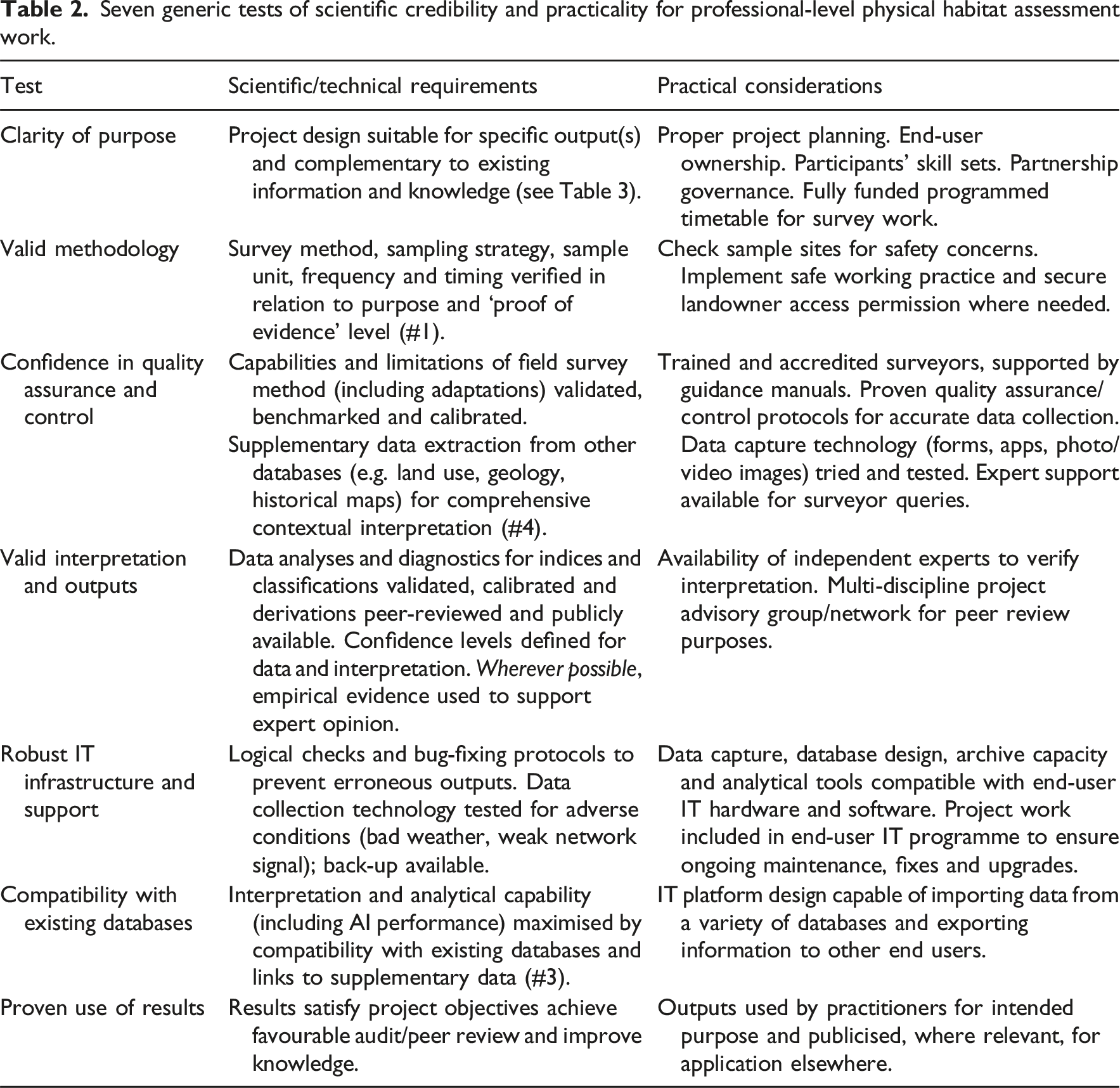
Seven generic tests of scientific credibility and practicality for professional-level physical habitat assessment work.
Seven generic categories of survey purpose and examples of field methods used.
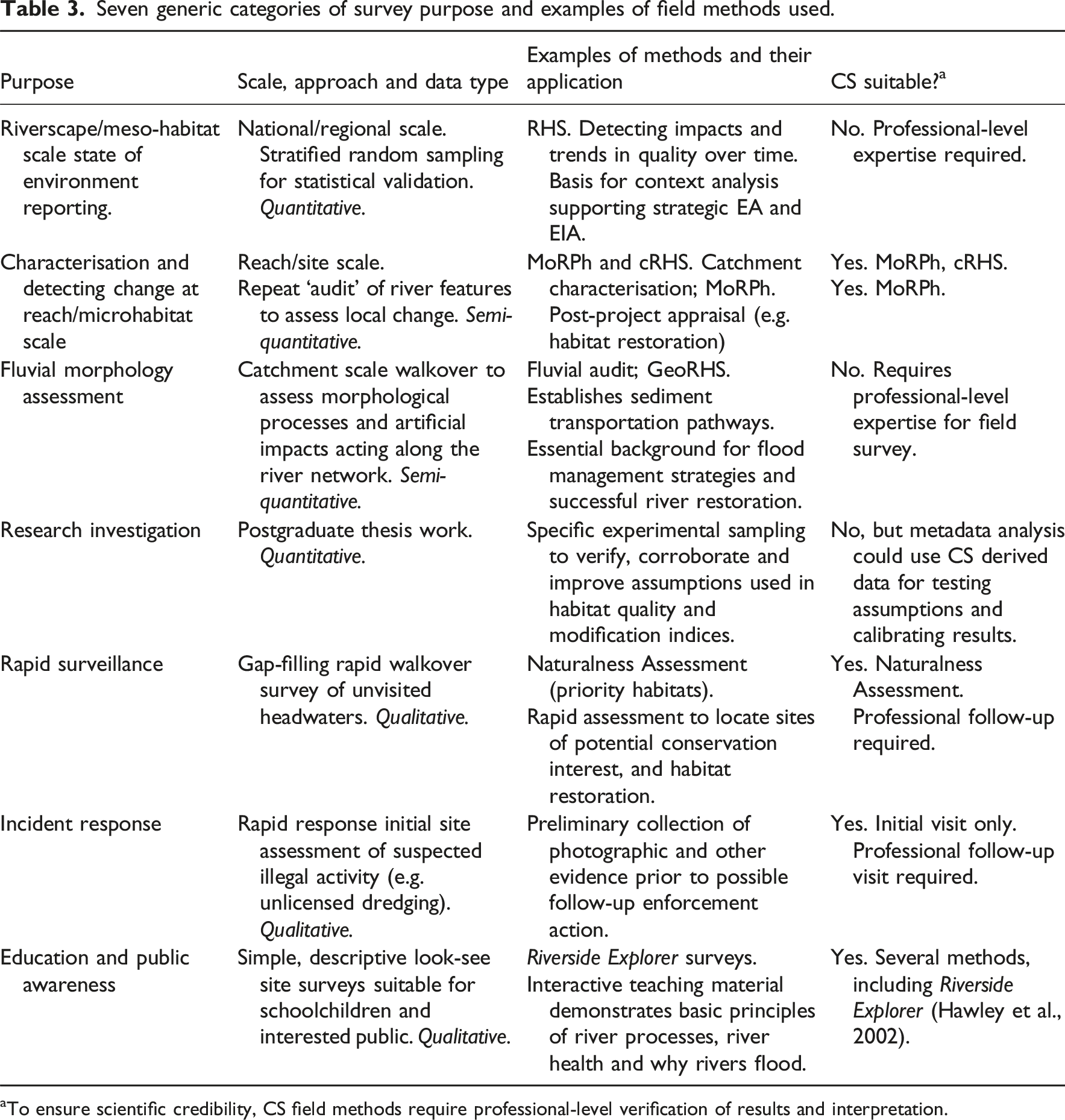
aTo ensure scientific credibility, CS field methods require professional-level verification of results and interpretation.
The three CS-designed methods highlighted in Table 3 have recently been used (two in England, cRHS in Wales) but they are still under development. Although training has been developed, there is no coordinated deployment plan and no formal protocols for independent peer review, data-sharing, harmonising IT platforms and ways of demonstrating environmental benefits resulting from the work. All three would probably fail at least one of the EA’s guiding principles for CS partnership working. Above all, there is uncertainty about funding the survey work, and the associated costs of professional input needed for training, surveyor support, quality assurance and control and interpretation, IT development and dissemination pathways.
The crux of the matter is trust – and therefore use – of CS data by professional river scientists. To that end, we recommend that a special workshop/forum is convened, involving experts from different scientific disciplines, end-users, statutory and NGO professionals, environmental consultancies and CS surveyors, with the specific aims of considering how to harmonise deployment of CS for physical habitat assessment. This would build on the substantial background work generated by the CaSTCO project and European (CEN) guidance standards, plus early experience of CS surveys. It would make recommendations covering topics such as follows: - independent peer review of data collection and interpretation; - common standards on nomenclature and technical definitions; - national and catchment sampling strategies for maximising use of existing data for harmonising planned and ad hoc surveys; - technical specifications for different kinds of purpose-led surveys; - independent provision of training and accreditation; - compatibility of IT platforms for data transfer, interpretation and dissemination; - securing critical mass and career development for professional scientists; - long-term monitoring needs and associated deployment plan; - best practice examples of uptake and use; - a promotion plan to raise awareness of multiple stressor impacts and remedies; - funding streams to deliver the above.
The outputs from these topics could be published as a series of papers in a special issue of a relevant journal, in the same fashion as those that provided the audit trail for method development and deployment of RHS and associated methods (Aquatic Conservation: special issue volumes 8(4),1998: 383-644; 12(4),2002: 327-483 and 20(Suppl. 1),2010: S1-S130).
Organisations such as CIWEM and CIEEM, plus RRC have an important role to play in developing a coherent, coordinated and credible CS contribution to monitoring the physical aspects of river health. Collective understanding and transparent standards of practice would provide reassurance for those commissioning work and build trust between professional scientists and CS volunteers. And, ultimately, improve the chances of environmental improvement that is the common objective of all concerned.
Conclusions
If multiple stressors on river systems are to be monitored and tackled in a coherent and efficient manner there are policy and resource implications for water management. Hydromorphological disruption is an important stressor but its profile and associated assessment and monitoring effort are low compared to water pollution. To restore river health fully in the long-term, redressing the current imbalance caused by the domination of tackling water pollution is needed. CS can play a powerful advocacy and operational role in that rebalance.
Better understanding of morphological (and especially hydrological) processes and disruption at local and broader scales is needed, plus monitored examples that prove beyond doubt the multiple benefits of habitat recovery work. Well-directed and suitably competent CS ‘monitoring’ can contribute to better understanding but more testing, calibration and harmonisation of methods are required to achieve the necessary confidence for wide (but standardised) uptake.
Several scientific, technical, IT and practical challenges need to be resolved to ensure optimum sharing of knowledge and use of resources. Above all, CS cannot and must not replace professional river science. We have made recommendations covering these challenges that would help to provide reassurance to the professional community, scientific and legal credibility and a feasible long-term monitoring strategy.
Whilst nationally identified targets for habitat protection and restoration are readily adopted by local, place-based, projects, involving fit-for-purpose CS involvement, it is vital that for scientific credibility and knowledge transfer, data are compatible with established survey and monitoring programmes and associated IT platforms. The EA’s encouragement of CS comes with, albeit latent, protocols, presumably to avoid a complex and costly legal situation with undisciplined evidence, however useful it is in drawing attention to a problem.
Ultimately, successful harmonisation of professional and CS effort will be determined by those organisations who commission monitoring surveys and use the results to improve river condition. Funding that deployment, especially in times of financial constraint, remains a major concern but that should not prevent all interested parties taking the opportunity to make progress on collective action.
Footnotes
Acknowledgements
Many of the insights, evidence and opinions gained for this paper derive from our participation as advisors to the CaSTCo project. We also acknowledge the help of the many colleagues who have helped us develop and apply systems of hydromorphological survey and assessment over the last 40 years. Special thanks for help with this paper go to Chris Mainstone, John Lewin and Pete Scarlett. We also gratefully acknowledge the help provided by two anonymous reviewers.
Ethical considerations
Neither is relevant to the research methods used: essentially literature-based and collaborative.
Funding
The authors disclosed receipt of the following financial support for the research, authorship, and/or publication of this article: We received funding from the CaSTCo project (![]() ) for advisory work to review hydromorphological methods in relation to suitability for citizen science participation. Our views are entirely personal and do not represent an output from the CaSTCo project.
) for advisory work to review hydromorphological methods in relation to suitability for citizen science participation. Our views are entirely personal and do not represent an output from the CaSTCo project.
Declaration of conflicting interests
The authors declared no potential conflicts of interest with respect to the research, authorship, and/or publication of this article.
Data Availability Statement
Not relevant to this paper. We use public sources with appropriate acknowledgement.