
Abstract
Infilled lakes are a prevalent geomorphic feature in the intricate high mountain landscape of the Cordillera Blanca, Peru. Despite their apparent geomorphic, hydrological, and ecological importance, a systematic inventory of these areas has been lacking. This study presents an inventory of infilled lakes in the Cordillera Blanca. A total of 962 infilled lake polygons have been manually mapped, covering an area of nearly 90 km2 (the area of individual mapped polygons ranges from 0.001 km2 to 1.760 km2), more than double the area of existing lakes (40 km2) and the majority of flat areas (62% of areas with slope ≤5°). The study reveals that infilled bedrock-dammed lakes are the most common type (42%), while moraine-dammed lakes account for the majority of the infilled lake area (52%) and sediment volume (52% to 57%). Considering high uncertainty of infilled basins’ morphology, the estimated sediment volume of infilled lakes ranges between 0.9 km3 and 2.3 km3 (compared to 0.79 km3 to 1.15 km3 of water stored in existing lakes). The case study of Lake Aguascocha catchment reveals a mean sediment yield of 0.64 to 1.63∙106 m3∙km−2 during the past 10.7 ± 0.3 ka, that is, a mean annual sediment yield of 58.5 to 156.4 m3∙km−2∙yr−1. Furthermore, 65 locations where preserved geomorphic evidence indicates possible outburst floods in the past are identified. These areas are particularly important for understanding patterns of lake outburst occurrence on longer timescales than traditionally considered in lake outburst flood hazard studies. The dataset presented in this study is intended to serve as a basis for identifying sites suitable for further site-specific paleo-geographical, sedimentological, geochronological as well as broader mountain landscape evolution studies.
Keywords
Introduction
High mountain lakes exhibit shorter longevity compared to the lakes located in less dynamic environments (Costa and Schuster, 1988; Korup and Tweed, 2007). They may disappear due to (i) gradual or episodic lake drainage resulting from successive dam incision or lake outburst); (ii) drying up of a lake caused by changing climatological, hydrological, or glaciological conditions in the lake’s catchment, or anthropogenic influences; and (iii) sediment infill gradually deposited within the lake’s basin over time. Often, these mechanisms are acting in parallel, such as gradual incision of a dam and gradual sediment infill.
Andean infilled lakes hold significant geomorphic, hydrological, ecological, and social importance (Glas et al., 2018; White-Nockleby et al., 2021). The geomorphic importance of high mountain lakes lies in their role as local erosion base, acting as sediment traps that retain material transported by streams. Consequently, sections downstream of the lakes experience increased erosion. As sediment traps, infilled lakes contain invaluable proxy data for paleo-geographical, paleo-climatological, and paleo-environmental reconstructions (e.g., Sabatier et al., 2022; Swann et al., 2022) but may also accumulate heavy metal contaminants released from recently deglaciated areas (e.g., Custodio et al., 2021).
The hydrological importance of infilled lakes lies in their water storage capacity and flow contribution during the dry season (Glas et al., 2018; Wunderlich et al., 2023). According to Huss and Hock (2018), the Tropical Andean catchments already experienced peak water (i.e., the contribution of melting glaciers already reached its maximum), and Baraer et al. (2012) concluded that a decline in dry season water availability has begun and will continue, underscoring the importance of water storages outside glaciers. Additionally, infilled lakes are often characterized as wetland areas supporting unique habitats of wild as well as domesticated fauna and flora (Domic et al., 2021; Yager et al., 2021) and are perceived as cultural landscape areas with considerable socio-ecological value (Hewitt, 2010; White-Nockleby et al., 2021).
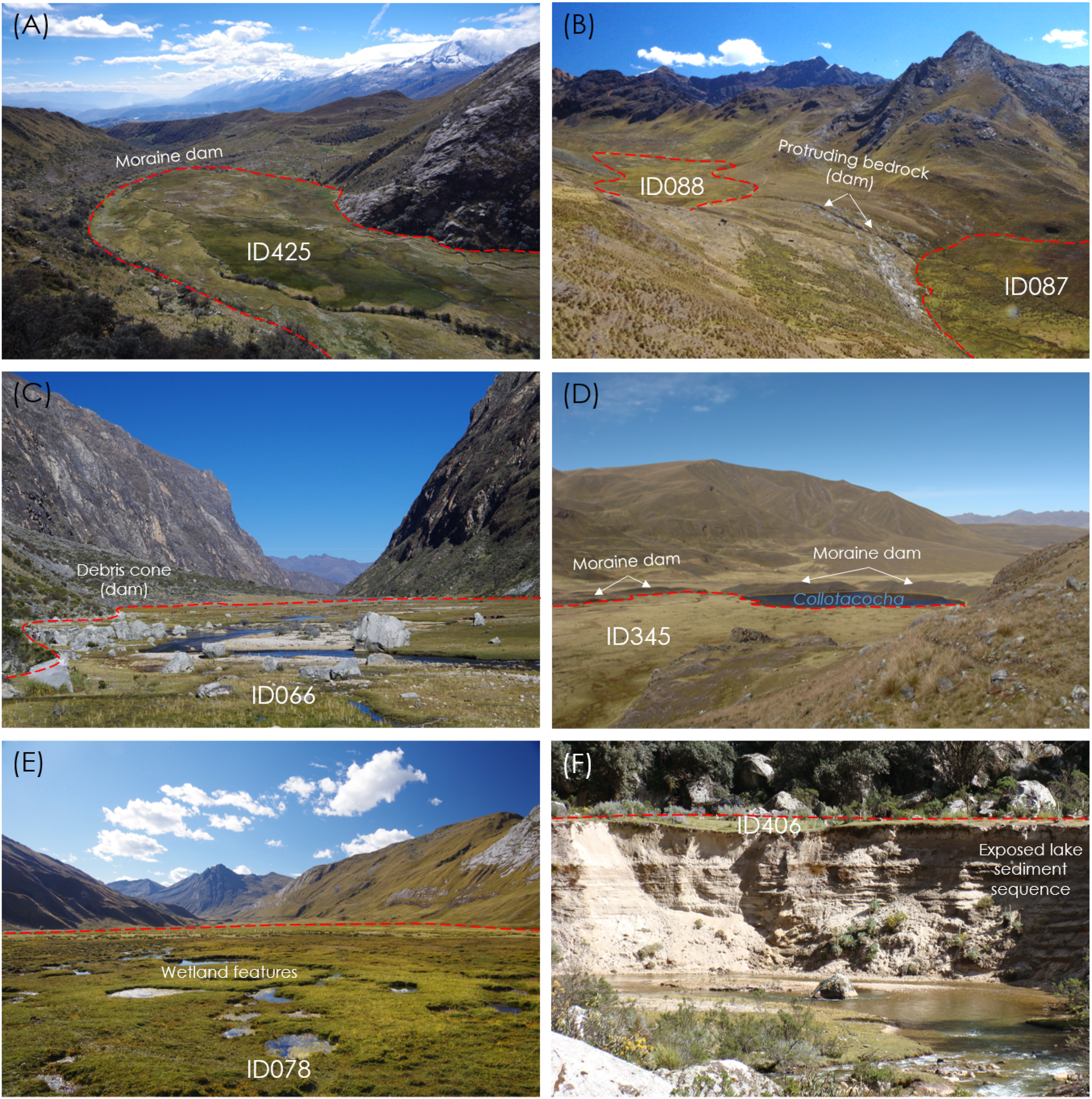
This study focuses on infilled lakes (“pampas”) in the Cordillera Blanca (Peru), where these forms are particularly abundant (see examples in Figure 1). While existing and future lakes, as well as recent lake outburst floods, have been studied extensively in the Cordillera Blanca (e.g., ANA, 2014; Iturrizaga, 2014; Colonia et al., 2017; INAIGEM, 2018; Tacconi-Stefanelli et al., 2018; Emmer et al., 2020; Wood et al., 2021; Emmer et al., 2022), infilled lakes and paleo-lake outburst floods from these lakes have received predominantly site-specific research attention so far, mainly exploiting lake sediments for paleo-environmental reconstructions and hydrogeological studies (see Section Previous infilled lake research in the Cordillera Blanca). However, a comprehensive overview of infilled lakes within the assumed Last Glacial Maximum (LGM) limits in Cordillera Blanca is lacking. The scientific questions are addressed in this study include the following: (1) What is the distribution of infilled lakes in the Cordillera Blanca within the LGM spatial limits and the post-LGM timeframe? (2) What is the total estimated volume of sediment infill and sediment yield in a selected catchment? (3) Does any morphological evidence corroborate the occurrence of lake outburst floods from infilled lakes beyond the LIA period? (4) How similar or different are dataset of infilled and existing lakes in terms of lake dam types, areas, and elevation? The examples of infilled lakes of the Cordillera Blanca and their typical features. (a) an example of infilled moraine-dammed lake in the Mullaca valley, Central Cordillera Blanca; (b) infilled bedrock-dammed lake in the unnamed tributary valley of the Upper Champará river, Northern Cordillera Blanca; (c) infilled landslide-dammed lake in the Santa Cruz valley, Northern Cordillera Blanca; (d) infilled and existing parts of moraine-dammed lake Collotacocha, Pumahuaganga valley, Southern Cordillera Blanca; (e) wetland features typical for infilled lakes (example of infilled moraine-dammed lake in the Upper Champará river catchment, Northern Cordillera Blanca; (f) exposed horizontally layered lake sediments of the failed landslide-dammed lake Jircacocha in the Cojup valley, Central Cordilera Blanca. All images were taken by the author between 2012 and 2021.
These questions stem from the necessity to better understand long-term evolution of lakes and landscape dynamics in the deglaciated areas of the Cordillera Blanca.
Study area
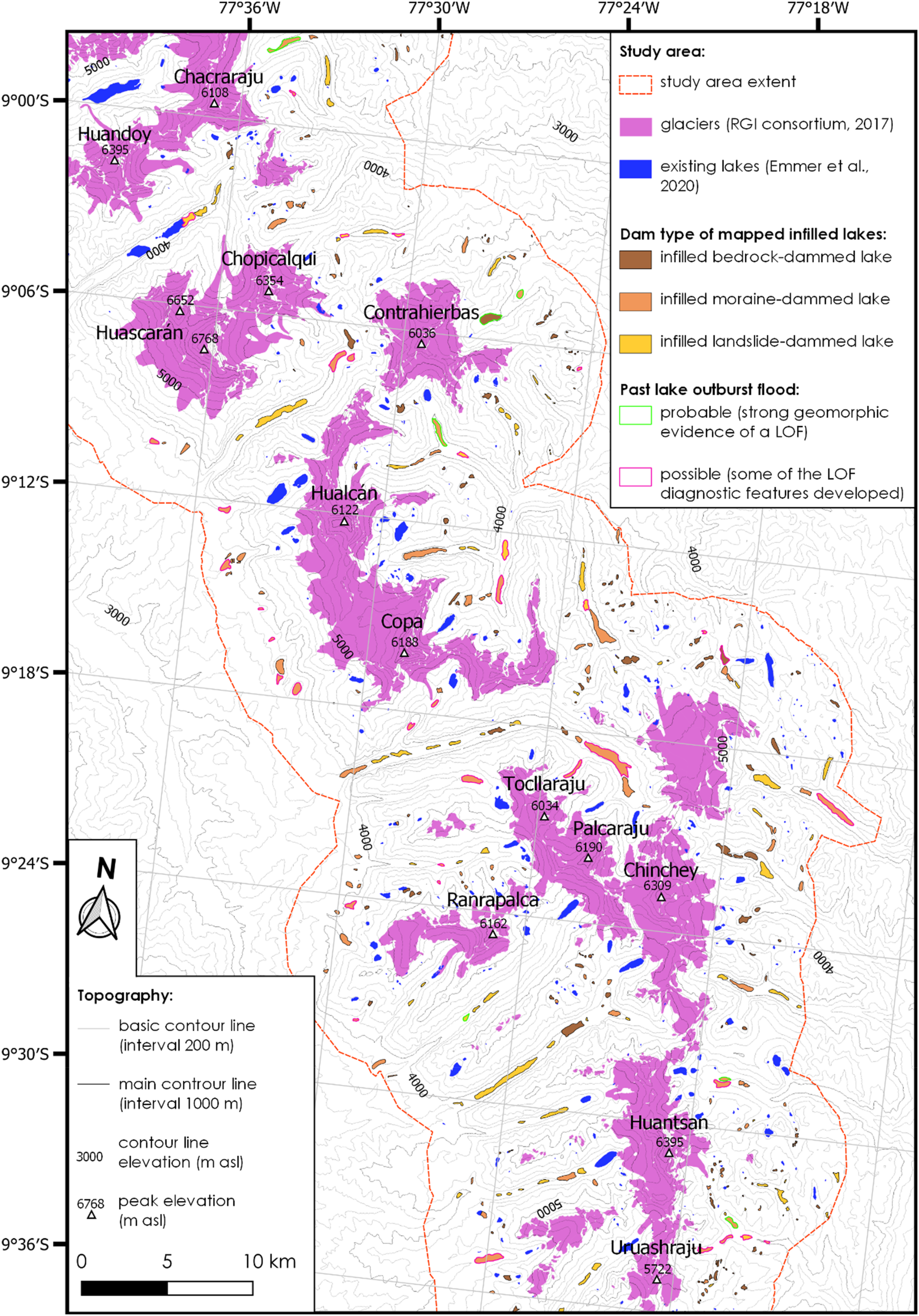
The Cordillera Blanca, spanning from 8°15’S to 10°15’S (Figure 2), is the world’s most heavily glacierized tropical range (Georges et al. 2004; Vuille et al., 2018) with several massifs exceeding 6000 m asl, including the highest Peruvian peak—Huascarán Sur (6768 m asl). The current glacier extent of less than 500 km2 (e.g., INAIGEM, 2018; Seehaus et al., 2019) is only the remnant of past glacier extents (e.g., Clapperton, 1983; Kaser and Osmaston, 2002; Rodbell et al., 2009; Mark et al., 2017). The study area, main glacierized massifs, rivers catchments, existing lakes and the location of field images.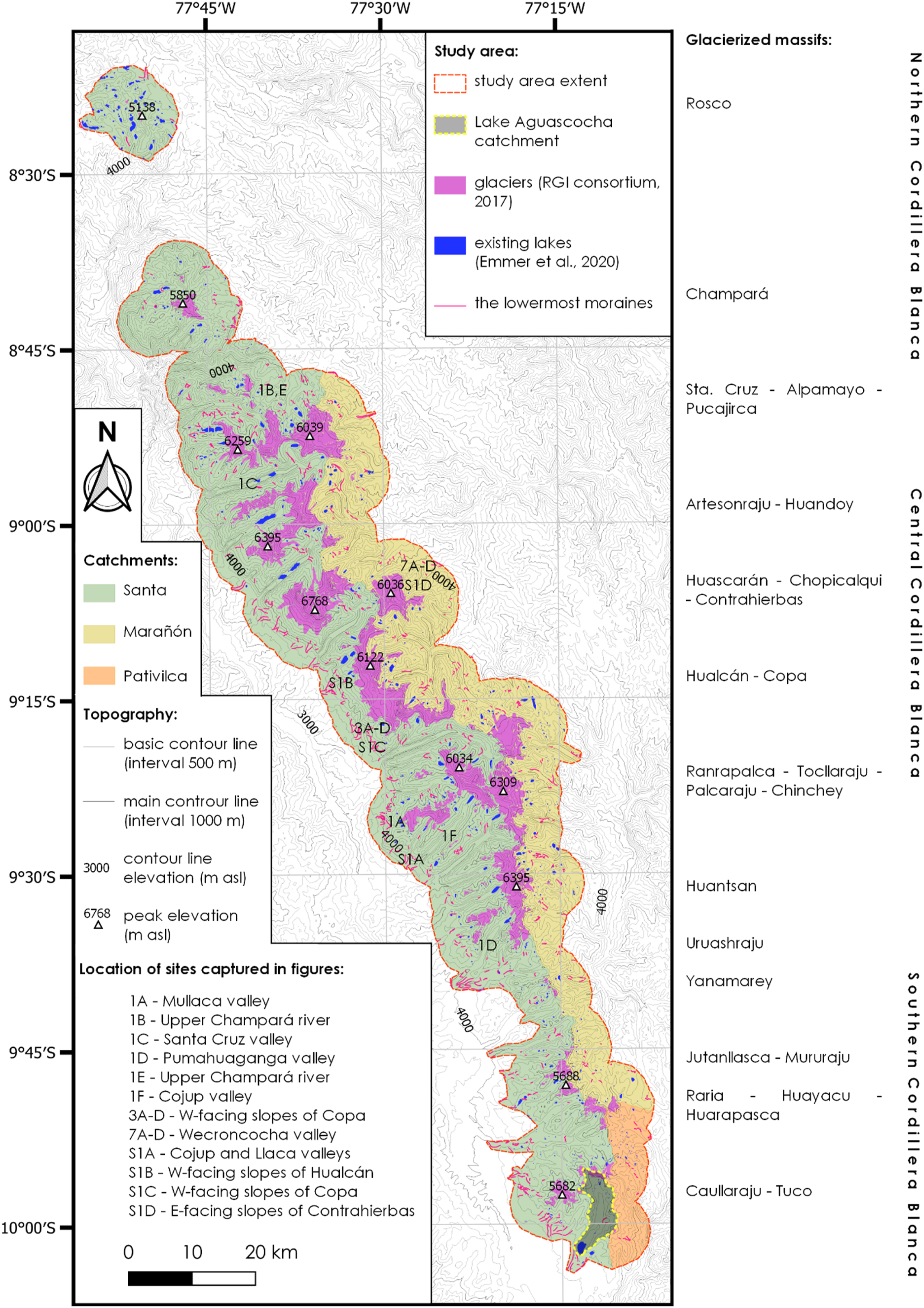
Past glacier fluctuations in the Cordillera Blanca: A brief overview
Numerous studies focused on Late Pleistocene, Holocene, and recent glacier fluctuations in the Tropical Andes in general, and in the Cordillera Blanca in particular. Clapperton (1972) provided an overview of early glaciological studies dating back to the 1930s and 1940s (e.g., Kinzl, 1935; Broggi, 1943; Oppenheim, 1945). Several researchers employed 10Be dating to estimate the age of well-preserved moraines in selected valleys of the Cordillera Blanca (Rodbell, 1993; Farber et al., 2005). Farber et al. (2005) found that the oldest moraines in some valleys date back to >400 ka (i.e., pre-dating the last interglacial). Smith et al. (2008) later provided the comprehensive overview of the LGM reconstructions. The local LGM of Rurec moraines was dated to 29 ka (Farber et al., 2005), while Lateglacial/Early Holocene readvances were dated to 16.5 ka (Rodbell, 1993; Farber et al., 2005).
Using the toe-to-headwall-altitude ratio method, Rodbell (1992a) reconstructed the LGM equilibrium line altitude (ELA) in the Cordillera Blanca to 4300 m asl, while the LGM moraines reached elevations down to 3700 m asl (Smith et al., 2008). Rodbell et al. (2008) reviewed in detail the chronology of Lateglacial moraines in the Andes, including the Holocene glacial history of the Cordillera Blanca. Jomelli et al. (2014) highlighted that glaciers expanded to a larger extent during the Antarctic cold reversal (14.5-12.9 ka) than during the Younger Dryas (12.8-11.5 ka) throughout the Tropical Andes. Based on the evidence from the Jeullesh and Tuco valleys, Glasser et al., (2009) concluded that there were three to four stillstands during the 12.5-7.6 ka, with an apparent cooling period around 8.2 ka. Holocene glacier fluctuations have been more recently reviewed by Solomina et al. (2015). Several studies also investigated local moraine assemblages in selected locations with well-preserved moraine records in the Cordillera Blanca, for example, in the Lejiamayu valley (Emmer et al., 2021) or on the west-facing slopes of the Hualcán massif (Giraldez, 2011), both identifying several generations of moraines embedded within the LGM spatial limits (LGM, Early Lateglacial, Antarctic Cold Reversal, Early Holocene, LIA-Neoglacial, and the most recent advance in the 1920s).
More recently, Mark et al. (2017) reviewed the last deglaciation in Peru and Bolivia. Further, Jomelli et al. (2009) elaborated in detail the fluctuations of tropical Andean glaciers during the last millennium. Withing the Little Ice Age (LIA) timeframe, Solomina et al. (2007) and Jomelli et al. (2008) employed lichenometry to date the LIA moraines, revealing two peaks in the Cordillera Blanca. Kaser (1999) focused on modern fluctuations of the tropical glaciers, Rabatel et al. (2013) reviewed the evolution of tropical Andean glaciers in past centuries, and Vuillle et al. (2018) addressed the impacts, uncertainties and challenges associated with recent rapid decline of tropical glaciers.
While geomorphic evidence of the pre-LGM glaciations is sparse and only present in certain locations (e.g., Cojup valley, Farber et al., 2005), abundant moraines of the LGM age and younger are conspicuous landforms in the landscape of the Cordillera Blanca. These moraines are associated with numerous existing (Emmer et al., 2020) as well as infilled lakes (Figure 1).
Previous infilled lake research in the Cordillera Blanca
Since the retreat of the glaciers from their past limits (especially the LGM and the LIA), many lakes have formed and have subsequently been infilled or have drained or dried up, and a number of studies have focused on infilled lakes of the Cordillera Blanca previously. For instance, the importance of infilled lakes for groundwater storage has been highlighted by Glas et al. (2018, 2019). Lake sediments have been exploited for paleo-environmental reconstruction by Stansell et al., (2017) who explored ocean-atmospheric forcing of the Lateglacial and Holocene glacier fluctuations. Seltzer and Rodbell (2005) analyzed sediments of Lake Parón located upstream Caráz, and another study focused on distinguishing and quantifying sediment sources of this lake later on (Navas et al., 2022). Rodbell et al. (2008) exploited the sediments of Lake Queshque and analyzed 18 ka of sedimentary record there. Recent sedimentation rates have been studied in the proglacial lake Llaca located upstream of Huaráz (Perez et al., 2023), and in the lakes that formed as a result of the rapid retreat of Yanamarey glacier (Lopez-Moreno et al., 2017).
Study area delimitation
The characteristics of the study area.
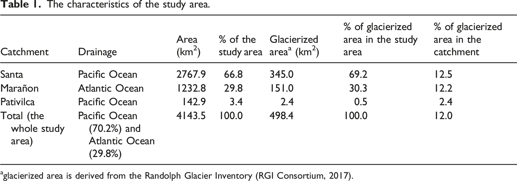
aglacierized area is derived from the Randolph Glacier Inventory (RGI Consortium, 2017).
Data and methods
Materials, data and software
This study integrates the analysis of: (i) remotely sensed images; (ii) digital elevation model (DEM); (iii) existing mapping products; and (iv) field data. High-resolution optical images available from ESRI and Google Earth collections accessible as web mapping services (WMS) were used in this work (see Data availability section for more details). These include CNES/Airbus and Maxar Technologies images with resolution of 0.6 to 1.2 m and acquisition date of the most recent scene ranging across the study area from July 2019 to April 2022 with the major part of the study area (section Alpamayo – Tullparaju) covered by CNES/Airbus images acquired in September 2021. Further, cloud-free (max. cloud coverage 8%) Sentinel-1 and Sentinel-2 optical images and multispectral products (false color, NDVI, NDWI, and moisture index) available from the EO browser (https://www.sentinel-hub.com) were used as additional insight in case of mapping or interpretation ambiguity.
The RGI (RGI Consortium, 2017) was used as a baseline for current glacier outlines. Further, morphometrical analysis is based on the radiometric terrain-corrected 12.5 m ALOS PALSAR DEM composited from four frames (AP_27249_FBS_F6980_RT1; AP_27249_FBS_F6990_RT1; AP_27249_FBS_F7000_RT1; AP_27249_FBS_F7010_RT1) downloaded from the Alaska Satellite Facility webpage (https://asf.alaska.edu/data-sets/sar-data-sets/alos-palsar/). The DEM analysis, as well as mapping, has been performed in the freeware software QGIS v. 3.16.15—Hannover released in October 2020 (available from: https://qgis.org/). Selected valleys have been visited by the author during repeated field surveys between 2012 and 2022 (11 months in total). The purpose of those stays was reconnaissance and photo documentation for the validation of remote sensing data analysis.
Study workflow
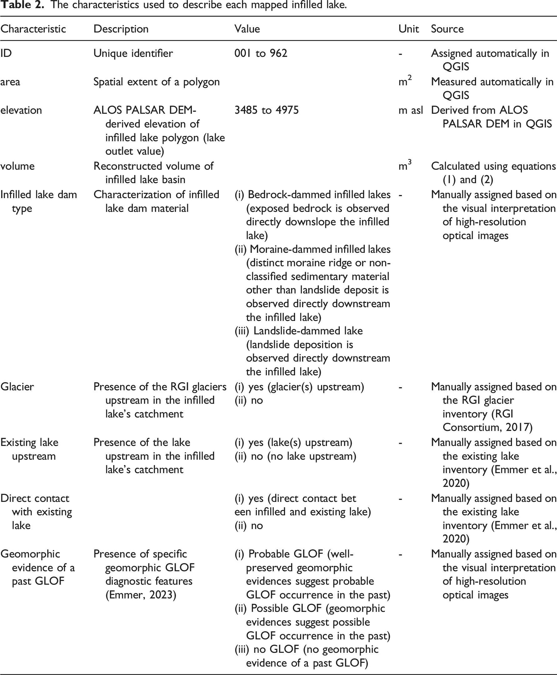
The characteristics used to describe each mapped infilled lake.
Geomorphological mapping of infilled lakes and lowermost moraines
The mapping was performed in QGIS environment, using ESRI and Google Earth WMS image collections and ALOS PALSAR composite DEM. In order to ensure mapping and interpretation consistency, the mapping was performed by a single person (the author) with the constant mapping scale of 1:10,000. The visibility at this scale also defines the minimum size of mapped features to approximately 1000 m2 for infilled lakes and 60 m length for the lowermost moraines. A finer scale was used for assigning qualitative characteristics to mapped infilled lakes.
Building on the experience gained a geomorphological mapping campaign on a catchment scale (Emmer et al., 2021), the criteria used to map a moraine were set as follows: (i) linear, downstream-oriented geometry; (ii) ridge-shaped cross-profile morphology; (iii) unsorted sediment material with the presence of large boulders. In case of valleys where several generations of moraines are present, those located farthest from the current glaciers (in the lowermost elevations) were considered.
Following criteria were used for considering a specific area an infilled lake: (i) the location in predominantly flat areas (ALOS PALSAR DEM-derived slope ≤5°); (ii) the location in areas with sediment cover (i.e., excluding areas with exposed bare bedrock); (iii) the presence of wetland features (small water bodies, water-soaked areas); (iv) the absence of trees and forests; (v) identifiable damming structure (see Figure 3). Three types of damming structures (infilled lake dam types) are distinguished: (i) moraine-dammed infilled lakes; (ii) bedrock-dammed infilled lakes; and (iii) landslide-dammed infilled lakes (see Figure 1 for field examples). A bedrock-dammed type is assigned whenever exposed bare bedrock is observed directly downslope of the infilled lake (typically infilled lakes located in former glacial cirques or over-deepened terrain). A landslide-dammed type is assigned whenever a landslide deposit (mass movement deposit in general) is observed directly downstream of the infilled lake. A moraine-dammed type is assigned whenever a distinct moraine ridge or non-classified sedimentary material other than landslide deposit is observed directly downstream of the infilled lake. The other qualitative characteristics explored in this study include (i) presence/absence of RGI glacier(s) upstream the infilled lake; (ii) presence/absence of existing lake(s) upstream the infilled lake; and (iii) direct contact with existing lake(s). The input data, mapped lowermost moraines and infilled lakes beneath the west-facing slopes of the Copa massif (6188 m asl). (aThe input data, mapped lowermost moraines and infilled lakes beneath the west-facing slopes of the Copa massif (6188 m asl). (a) WMS ESRI optical image overlaid with the RGI layer of glaciers (RGI consortium, 2017) and the layer of existing lakes (Emmer et al., 2020); (b) topographical data derived from ALOS PALSAR DEM, with only visualized slopes ranging from 0° (green color) to 5° (gray color); slopes steeper than 5° are considered irrelevant for the identification of infilled lakes in this study; (c) mapped lowermost moraines and infilled lakes; (d) field image with clearly visible moraines walls of assumed LGM age and three infilled lakes (ID171, ID172, and ID173). Field image was taken by the author in 2019.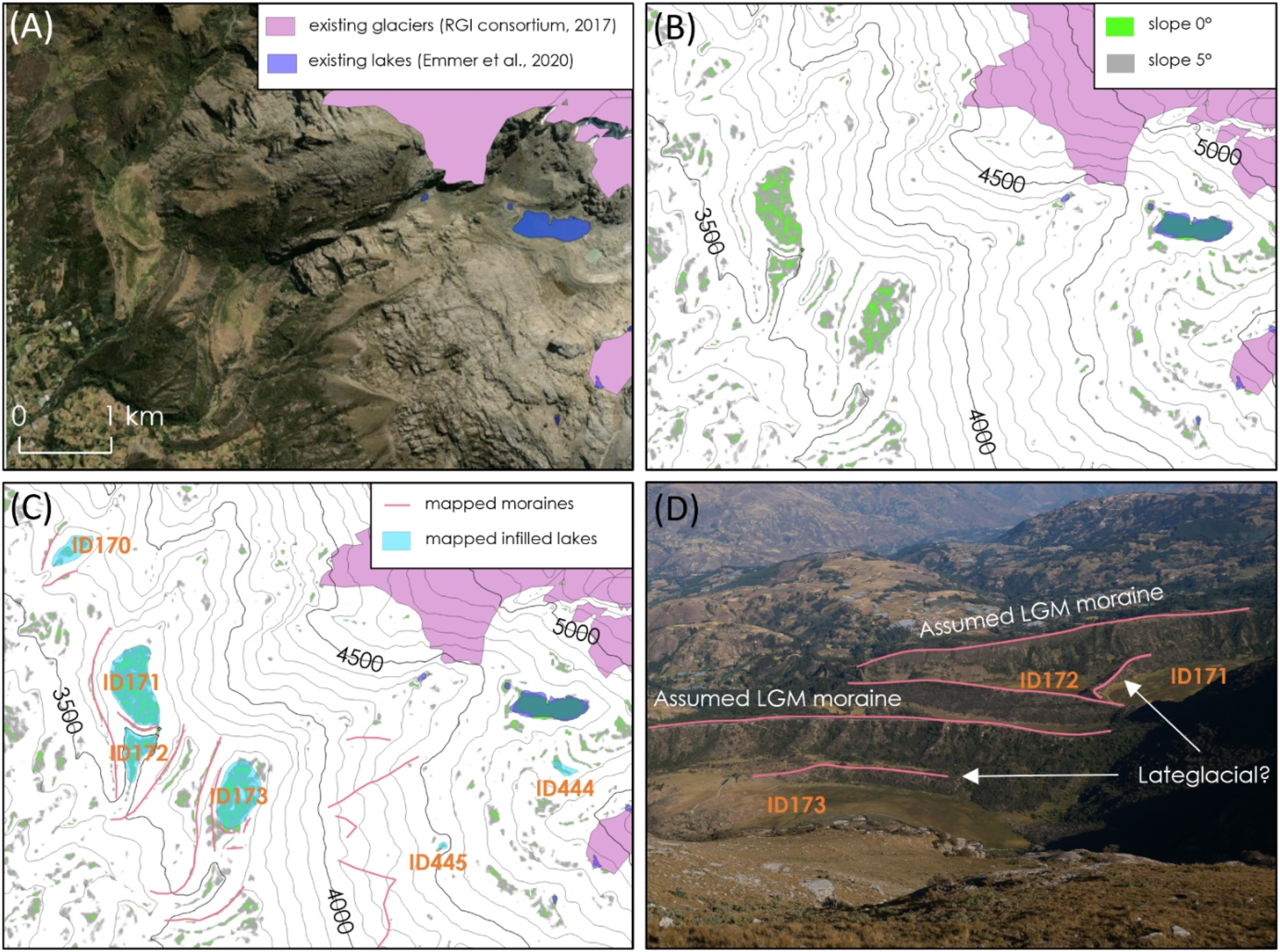
Further, each of the mapped infilled lakes as well as downstream areas were visually checked for the presence/absence of geomorphic evidence of past lake outburst floods (LOFs). It was shown previously that major post-LIA GLOFs created characteristic geomorphic imprints in the landscape (Robitaille and Dubois, 1995; Emmer, 2017; Emmer et al., 2022), although the longevity of these imprints (LOF diagnostic features) may be limited (Emmer, 2023). GLOF diagnostic features that are relevant for the LGM timescale that were sought in high-resolution images and DEM include breached dams (deeply incised dam body, typical for moraine and landslides dams), outwash fans (conspicuous deposition of large boulders located downstream a breached dam), terraces and terraces-like features, disproportionately large erosional features downstream from the lake associated with an excessive peak flow (beyond those of hydro-meteorologically induced floods), eddy bars, etc. However, LOFs typically do not develop all of these features (Emmer, 2023). Each of the mapped infilled lakes was then assigned to one of the three classes: (i) probable LOF (well-preserved geomorphic evidences suggest probable LOF occurrence in the past); (ii) possible LOF (geomorphic evidences suggest possible LOF occurrence in the past); or (iii) no LOF (no geomorphic evidence of a LOF in the past).
The infilled lake volume estimation
The Cordillera Blanca regions is well-known for long-term lake monitoring efforts and a large number of bathymetrical studies performed by Autoridad Nacional del Agua (ANA; National Water Authority) institute located in Huaraz (Carey et al., 2016). One of the first attempts to exploit these data and derive empirical scaling equation was done by Emmer and Vilímek (2014), who compiled data from 35 bathymetrical studies and came up with following power function for the estimation of lake water volume from lake area:
The Q1, Q2, Q3 and mean lake depths derived from the Muñoz et al. (2020) dataset used to estimate the plausible range of infilled lakes volume.
BD = bedrock-dammed lakes; MD = moraine-dammed (+landslide-dammed lakes).
The infilled lake volume is calculated as a product of lake area and mean depth, that is:
Sediment yield in Lake Aguascocha catchment
The sediment yield (m3⋅km−2⋅yr−1) has been estimated in Lake Aguascocha catchment (47.7 km2; 4284 m asl (Lake Aguascocha)—5487 m asl (Nev. Challua)) in the Tuco valley, upper Rio Santa catchment, Southern Cordillera Blanca (see Figure 2). This catchment was selected because: (i) still existing moraine-dammed Lake Aguascocha is located in the main valley and prevents any sediment to leave the catchment, therefore allows the calculation of sediment yield; (ii) moraines damming Lake Aguascocha were dated by Glasser et al., (2009), revealing the age of 10.7 ± 0.3 ka. It is therefore possible to quantify the sediment yield with given timeframe (see Figure S2).
Results
Classification, spatial characteristics, and distribution of infilled lakes
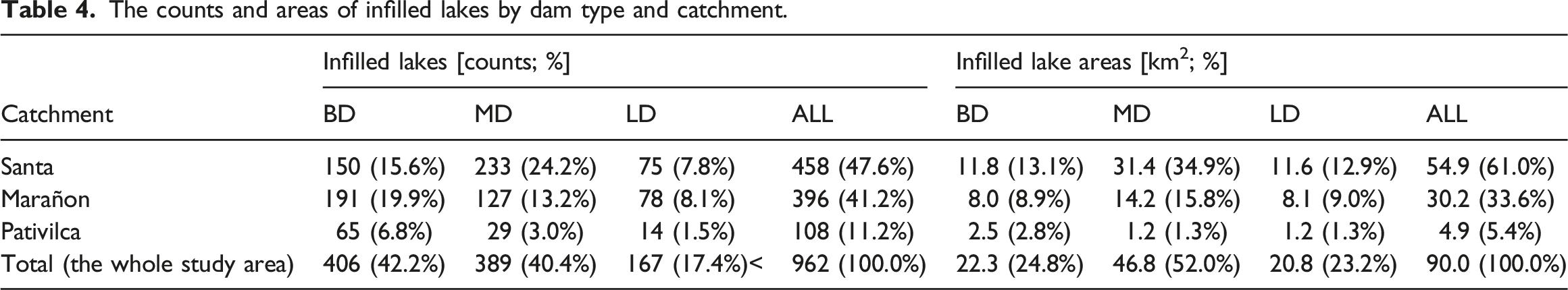
The counts and areas of infilled lakes by dam type and catchment.
Mapped infilled lakes in the Central Cordillera Blanca.
Infilled lakes are located at elevations ranging from 3485 m asl to 4975 m asl; however, the full range is only occupied by infilled moraine-dammed lakes (see Figure 5), and 97.9% of lakes are located above 3700 m asl, that is, above the lowest dated LGM moraine of Farber et al. (2005) and Smith et al. (2008). Infilled bedrock-dammed lakes are found from 3788 m asl to 4874 m asl, while infilled landslide-dammed lakes are located from 3558 m asl to 4602 m asl. Considering elevational bands (bins by 100 m), the highest concentration of infilled lakes is found between 4100 m asl and 4200 m asl (n=135 infilled lakes), between 4400 m asl and 4500 m asl (n = 131), and between 4200 m asl and 4300 m asl (n = 120), that is, around the LGM ELA proposed by Rodbell (1992a, 1992b). Slightly more than half of all infilled lakes (n = 495; 51.5%) are found in between 4100 m asl and 4500 m asl. A similar distribution pattern is observed for lake areas with 69.7% of infilled lake area located in between 3900 m asl and 4500 m asl. Individual elevational bands area characterized by different mean infilled lake area, ranging from 0.387 km2 in elevational band 3500 m asl to 3600 m asl (n = 9 lakes) and 0.150–0.180 km2 in elevational bands 3700 to 4100 m asl to < 0.060 km2 in elevational bands above 4500 m asl. he distribution of infilled lakes (parts A and B) and infilled lake areas (parts C and D) by lake dam type in elevational bands by 100 m.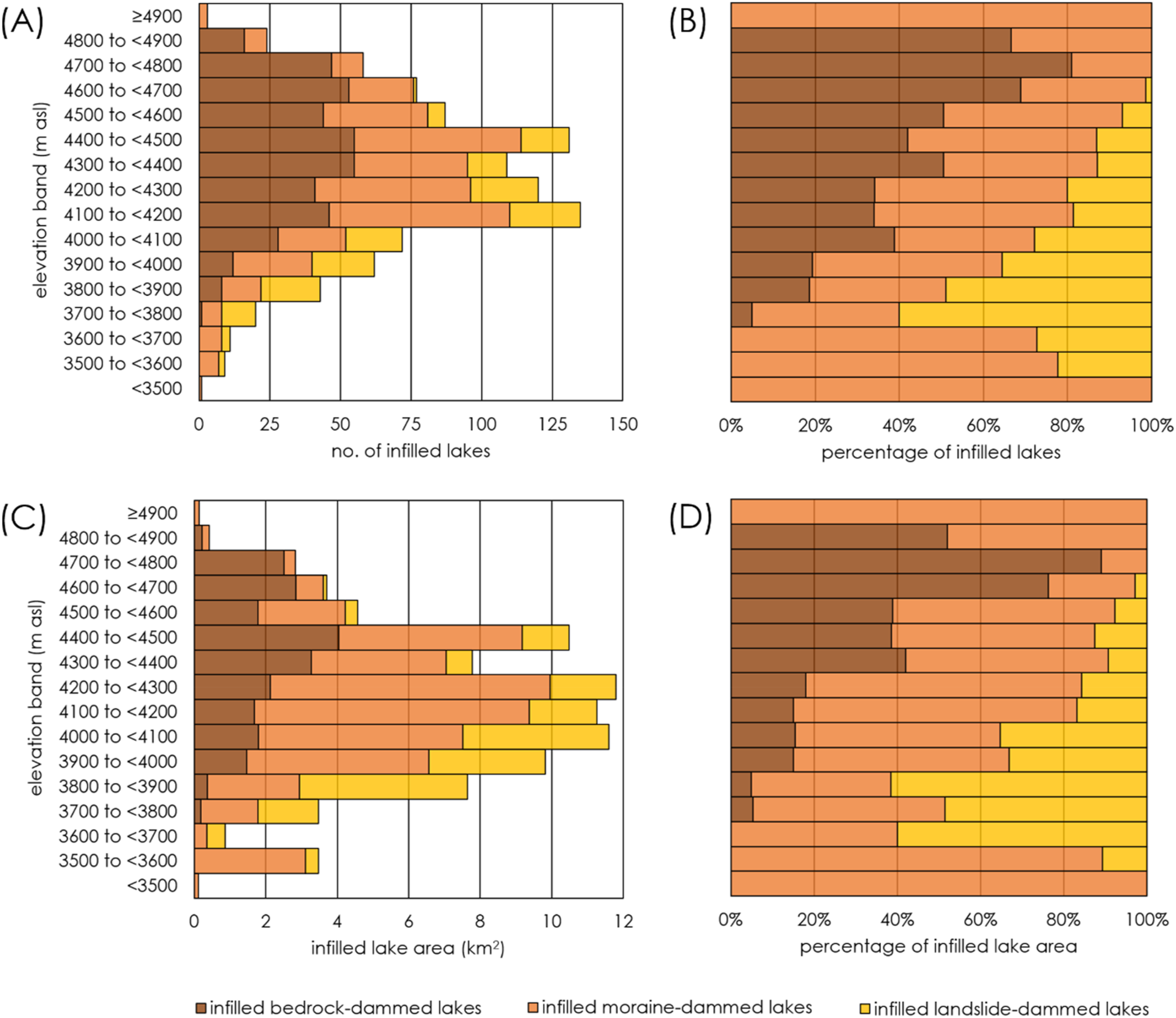
Furthermore, it is shown that a narrow majority of infilled lakes (n = 502; 52.2%) have any glaciers upstream in their catchments, implying that they are hydrologically connected to and fed by meltwater, while the remaining 460 infilled lakes (47.8%) are located in deglaciated catchments and do not at present receive any meltwater. However, substantial differences exist between individual lake dam types. While two-thirds of infilled bedrock-dammed lakes (n = 270; 66.5%) do not have any glaciers in their catchments, more than three-fifths of infilled moraine-dammed lakes and more than three-quarter of infilled landslide-dammed lakes do have glaciers in their catchments, suggesting that the formation of bedrock-dammed lakes is frequently associated with smaller (and short-living) glaciers.
Similarly, 54.0% of infilled lakes (n = 519) have existing lakes in their catchments, with substantial differences between individual lake dam types. While the majority of infilled bedrock-dammed lakes (n = 256; 63.1%) do not have any lakes upstream, 57.6% of infilled moraine-dammed lakes (n = 224) and 86.8% of landslide-dammed lakes (n = 145) do have existing lakes in their catchments. This suggests the position of individual lake dam types in multi-lake valley systems typical for the landscape of the Cordillera Blanca. The vast majority of infilled lakes are not in contact with any existing lake (n = 881; 91.6%), and this applies for all infilled lake dam types. The remaining 81 lakes (8.4%) are in the visually recognizable transition phase from an existing to an infilled lake (i.e., that both water surface and infilled areas are present). Nearly 40% of all lakes have glaciers as well as existing lakes in their catchments (see Figure 6). The Venn diagram of the percentages of lakes with glacier(s) in their catchments, existing lake(s) in their catchments and in direct contact with existing lake(s).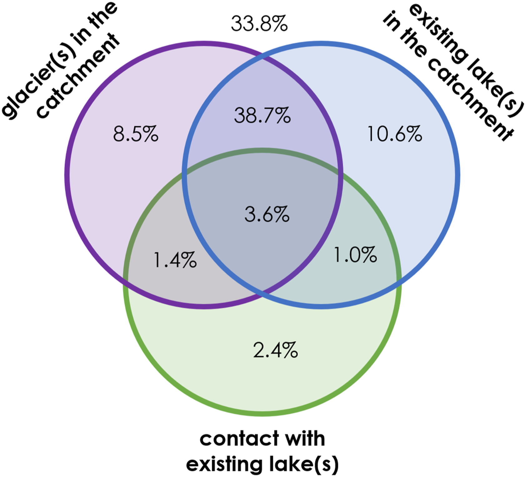
Sediment storage and sediment yield
The total estimated infilled volume is 1.486 (+0.828/−0.599) km3. The lower and the upper bounds considering Q1 and Q3 mean depths indicate that the volume of infilled lakes may range from 0.887 km3 (the conservative estimate) to 2.313 km3 (the least conservative estimate). The area-volume relationship developed by Emmer and Vilímek (2014) suggests the volume of infilled lakes 2.232 km3, that is, slightly below the least conservative estimate. The majority of the infilled volume (52% to 57%, depending on the volume estimation method used) is trapped in infilled moraine-dammed lakes, while infilled bedrock-dammed lakes account for 19% to 26% and infilled landslide-dammed lakes for 22% to 23%.
The total volume of 12 infilled lakes in the Lake Aguascocha catchment (including the infilled part of Lake Aguascocha) is 0.038–0.078 km3. Considering the catchment area (47.7 km2), these numbers correspond to the sediment yield 0.64–1.63∙106 m3∙km−2. Considering the age of a damming moraine (10.7 ± 0.3 ka; Glasser et al., 2009), the mean annual sediment yield during this period varies between 58.5 m3⋅km−2⋅yr−1 (conservative infilled volume estimate) and 156.4 m3⋅km_2⋅yr−1 (the least conservative estimate).
Potential paleo outburst flood sites
A detailed focus on GLOF diagnostic features during the infilled lake mapping (see Section Geomorphological mapping of infilled lakes and lowermost moraines) reveals 65 locations (infilled lakes) that could have possibly sourced an outburst flood in the past (Figure 4, (s)3 and (s)4), out of which 10 infilled lakes are classified as probable outburst flood sources (well-preserved geomorphic evidences suggest a probable outburst flood occurrence in the past; see Figure 7), and 55 as possible outburst flood sources (less preserved/less developed geomorphic evidences suggest a possible outburst flood occurrence in the past). The majority of outburst flood-producing infilled lakes (n = 50; 76.9%) are classified as infilled moraine-dammed lakes, followed by landslide-dammed (n = 11; 16.9%) and bedrock-dammed lakes (n = 4; 6.2%). The mean (median) elevation of outburst flood-producing infilled lake is 4023 m asl (3991 m asl), while the mean (median) elevation of all infilled lakes is 4303 m asl (4310 m asl). The example of a geomorphic evidence of past outburst flood(s) likely originating from the infilled lake ID017 in the Wecroncocha valley located beneath the east face of Contrahierbas massif (6036 m asl). Various outburst flood-associated landforms and features are highlighted. Image: CNES/Astrium from the WMS Google Earth collection.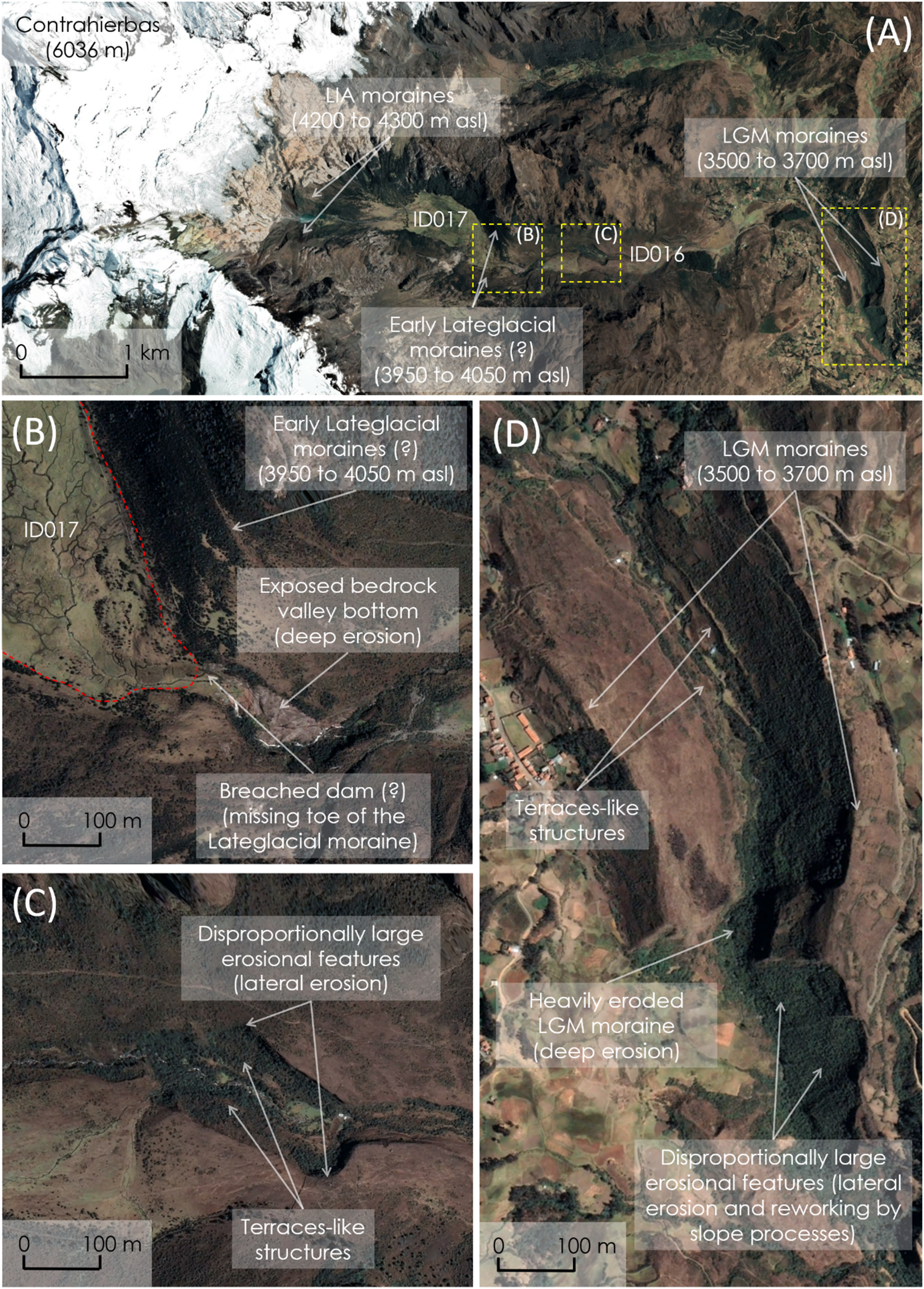
Discussion
Infilled versus existing lakes
Selected properties of infilled lakes (area, elevation, dam types) are compared with those of existing lakes (updated dataset of Emmer et al., 2020). Although the numbers of lakes in both datasets are comparable (924 existing lakes and 962 infilled lakes), existing lakes cover a total area of 40.3 km2, while infilled lakes cover 90.0 km2. Naturally, this is reflected in the total volume estimates. Wood et al. (2021) estimated the total volume of existing lakes in the Cordillera Blanca as 0.790 km3, while Muñoz et al. (2020) estimated the total volume of 1.150 km3 (about two-thirds of this volume is bathymetrically measured). The upper bound of the estimated total volume range for infilled lakes (0.887 km3 to 2.313 km3) is proportional to the total areas of existing and infilled lakes.
Figure 8(a) shows that the mean area of an infilled lake (93,525 m2) is more than a double the mean area of an existing lake (43,659 m2) and the median area of the infilled lakes dataset (35,429 m2) is more than four times the median area of the existing lakes dataset (7880 m2). This pattern is observed across lake dam types with the exception of landslide-dammed lakes. However, a limited number of existing landslide-dammed lakes (n = 29) needs to be taken into consideration here. The most frequent lake dam type in both datasets are bedrock-dammed lakes (49.5% of existing lakes; 42.2% of infilled lakes), followed by moraine-dammed lakes (37.6% of existing lakes; 40.4% of infilled lakes). Finally, the dataset of infilled lakes includes 179 landslide-dammed lakes which substantially enhances the previous inventory of Tacconi-Stefanelli et al. (2018) who found and analyzed 51 landslide dams in the slightly different study area. The increased share of infilled landslide-dammed lakes (17.4%) compared to the share of existing landslide-dammed lakes (3.1%) could be explained by (i) generally short longevity and likelihood of failure of landslide dams (Costa and Schuster, 1988; Korup and Tweed, 2007); (ii) the location of landslide dams in lower elevations and within large catchments, leading to faster sediment infill of lakes that they impound; and (iii) possibly incorrect classification of a bedrock-dammed or a moraine-dammed lake due to the post-infill deposition of landslide(s) in lake dam area. The comparison of areas (a) and elevations; (b) of infilled and existing lakes by lake dam type.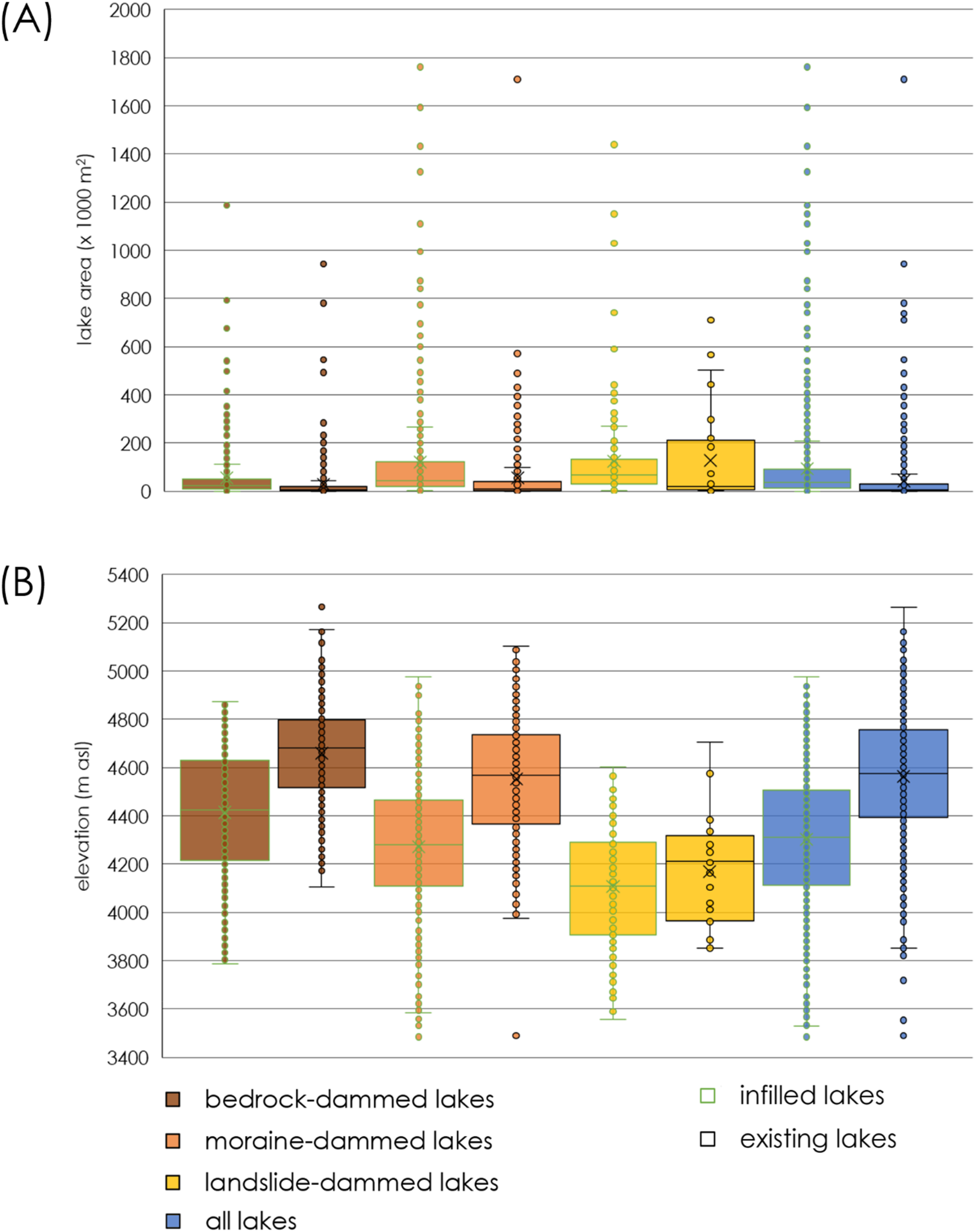
The area of the largest lake is comparable in both datasets (1.76 km2 among infilled lakes and 1.71 km2 among existing lakes) and suggests topographical constraints for the largest lakes in the region; however, the infilled lake dataset includes eight lakes with area >1 km2 while only two existing lakes exceed this size. This difference could be explained by topographical suitability for the evolution of large lakes in lower elevations with wide and less steep valleys (the majority of the largest lakes in the infilled dataset are LGM moraine-dammed lakes located below 4200 m asl). Decreasing mean area of lakes in different elevation bands (see Section Classification, spatial characteristics and distribution of infilled lakes) supports the concept of topographical control on the formation and evolution of glacial lakes (Emmer et al., 2020). However, no correlation is observed between the elevation and lake area (not even if only the large lakes are considered). This is further corroborated by elevation difference between existing and infilled lakes (Figure 8). The mean (median) elevation of existing lakes is 4562 m asl (4575 m asl) while 4303 m asl (4310 m asl) in the case of infilled lakes. The difference of mean, median, Q1 and Q3 elevations between existing and infilled lakes is between 200 and 300 m of elevation for individual lake dam types with only exception of landslide-dammed lakes (Figure 8), while a difference between the modern and LGM ELA is approximately 1000 m (Rodbell, 1992b). The second reason explaining the absence of small lakes among the infilled lakes (the existing lakes dataset includes 355 lakes <5000 m2, while only 54 infilled lakes were mapped in this areal bin) are mapping methodology discrepancies as well as limitations associated with increasingly diminishing recognizability of small infilled lakes in time (larger landforms and features tend to persist longer in the landscape; Emmer, 2023).
Paleo versus post-LIA lake outbursts
In their post-LIA GLOF inventory of the Peruvian and Bolivian Andes, Emmer et al. (2022) found that 61.9% of GLOFs originated from moraine-dammed lakes, while 34.4% from bedrock-dammed lakes and lakes with combined dams. However, only four infilled bedrock-dammed lakes are considered to produce a LOF in the Cordillera Blanca. This substantially decreased share can be explained by the absence of some of the typical diagnostic features associated with this lake dam type (a LOF from a bedrock-dammed lake does not produce breached dam) and limited longevity of others (Emmer, 2023).
The mean (median) elevation of the post-LIA GLOF-producing lakes in the Cordillera Blanca is 4548 m asl (4545 m asl), which is approximately 500 m higher than of mean and median elevation of the paleo outburst sources (see Section Potential paleo outburst flood sites). This elevational difference suggests that paleo outburst sites are especially those where the glaciers reached the lowest elevations, formed the largest lakes and created the long-lasting geomorphic imprints of outburst floods.
The paleo LOF per infilled lake ratio 0.068 (65 LOFs per 962 infilled lakes) corresponds well with the post-LIA GLOF per existing lake ratio 0.075 (Emmer et al., 2022). Importantly, some of the LOF-producing infilled lakes form cascades in a valley and several infilled lakes with developed LOF diagnostic features can actually be associated with only one event, as documented by the 2012 multi-lake outburst flood in the Santa Cruz valley (Mergili et al., 2018).
Mapping limits and uncertainties
Naturally, manual mapping based on visual interpretation of optical remote sensing data is tied with several limitations and uncertainties that need to be acknowledged. First, the qualitative criteria used for the identification and characterization of infilled lakes require expert assessment and thus include a subjective component. A strategy implemented for deriving the most reliable results builds on the experience gained from the previous research of existing lakes in the region, extensive field experience and mapping consistency. Second, the spatial extent of mapped polygons is a compromise between individual criteria. For instance, the spatial extent of an infilled lake basin needs to take into account the spatial extent of flat areas and spatial extent of wetland features, which may not overlap perfectly. This is especially the case of small infilled lakes in deeply dissected terrain where the resolution of the ALOS PALSAR DEM may indicate gently sloped areas. Further, rear parts of the original lake extent and areas close to the steep walls may have been overlaid by colluvial deposits and are not characterized by flat surfaces anymore. In addition, former lake bottoms may be inclined if the lake experienced an outburst flood. Therefore, the shape and the area of mapped polygons may not exactly fit the flat areas derived from a DEM. In addition, a decision as to whether a certain area used to be one larger lake or a complex of several smaller lakes requires expert judgment. The uncertainty associated with the resolution of remote sensing data is neglected since high-resolution optical data are used as the primary data source and other factors listed here may introduce even larger uncertainties.
The methodology of infilled volume estimation (Sections The infilled lake volume estimation and Potential paleo outburst flood sites) is tied with uncertainties that can hardly be quantified since no information about the volume of individual infilled lakes is available. In this study, I assume morphological similarity of the basins of existing and infilled lakes and use the bathymetric dataset of existing lakes of Muñoz et al. (2020) to estimate the volume of infilled lakes. However, it is important to point out that this dataset includes existing lakes in various stages of sediment infill. As a result, obtained infill volumes (especially the conservative estimate) may be underestimated.
Further, It is necessary to mention that the identification of paleo outburst flood sites (Sections Geomorphological mapping of infilled lakes and lowermost moraines and Potential paleo outburst flood sites) is associated with a large subjective component and uncertainty. Hewitt (2010) pointed out that geomorphic evidence such as a breached dam or terraces can also result from long-term erosion and don’t need to be necessarily associated with outburst floods. On the other hand, specific outburst flood mechanisms (such as seepage and piping) may not be captured in geomorphic evidence-based methodology used in this work. These mechanisms are, however, rather rare in the Peruvian Andes (Emmer et al., 2022). Apart from the need for time-consuming expert judgment-based visual interpretation of remote sensing images and identification of potential paleo LOF sites, the limiting factor is the longevity of LOF diagnostic features. Emmer (2023) suggested that the longevity of LOF diagnostic features is a function of LOF magnitude. Considering that the size of the largest lakes of the Cordillera Blanca is topographically constrained (see Section Infilled versus existing lakes; Emmer et al., 2022), the LOF magnitude and the longevity of LOF diagnostic features are limited too.
Paleo LOF sites identified in this work are intended to serve as the first-order guide for the location of detailed follow-up studies rather than a definitive inventory of LOFs in the post-LGM timeframe and spatial limits. To further improve this inventory, it is especially recommended to integrate high-resolution DEM analysis (e.g., Thorndycraft et al., 2016) with field and sedimentological work (Rothe et al., 2019; Vandekerkhove et al., 2020).
Conclusions
This study presents the first attempt to map the location and quantify the spatial extent and volume of infilled lakes within the assumed LGM limits in the Peruvian Cordillera Blanca—the most glacierized Tropical range of the world. It is demonstrated that 962 infilled lakes cover an area of nearly 90 km2 and constitute the majority (62%) of flat parts (≤5°) of the study area. Depending on the lake volume approximation method, the total infilled volume estimate ranges from 0.9 km3 to 2.3 km3. A comparison with the dataset of existing lakes reveals that infilled lakes are located in lower elevations (median 4310 m asl vs 4575 m asl) and that the maximum lake area (<2 km2) is topographically constrained and does not differ substantially between the two datasets. The insights from the catchment studied in detail suggest that mean annual sediment yield varies between 58.5 and 156.4 m3⋅km−2⋅yr−1 during past 10.7 ± 0.3 ka (i.e., mean sediment yield 0.64 to 1.63⋅106 m3⋅km−2). Furthermore, 65 locations with geomorphic evidence suggesting possible outburst flood occurrence in the past are identified.
Despite the clear regional focus of this study, its framework and remote sensing data-based methodological approach can be employed in various geographical settings. The unique insights into infilled lake types and assemblages—in combination with glaciation chronologies—can generate quantified estimates of lake evolution trajectories, lifetime, and dynamics of geomorphic processes in deglaciating mountain valleys. Further, the analysis of lake outburst patterns beyond commonly considered post-LIA timeframe is essential for understanding possible changes in frequency-magnitude relationship of these events over longer periods of time and in relation to (de-)glaciation phases.
The dataset of infilled lakes presented in this work can further be exploited for: (i) paleo-geographical and paleo-environmental reconstructions; (ii) high mountain landscape and lake evolution studies in the post-LGM timeframe; (iii) selection of suitable sites for detailed sedimentological and dating field studies; (iv) sediment yield and sediment dynamics studies in proglacial environments; (v) land use and land cover studies; and (vi) training and validation of semi-automated mapping methods and ice thickness models.
Supplemental Material
Supplemental Material - Infilled lakes (Pampas) of the Cordillera Blanca, Peru: Inventory, sediment storage, and paleo outbursts
Supplemental Material for Infilled lakes (Pampas) of the Cordillera Blanca, Peru: Inventory, sediment storage, and paleo outbursts by Adam Emmer in Progress in Physical Geography
Footnotes
Acknowledgments
The author would like to acknowledge insightful comments and suggestions of two anonymous reviewers that helped to improve the initial version of this study. In response to review comments, the author was asked to improve the clarity of written English, which was achieved using the online large language model, ChatGPT.
Author contributions
This research was designed and the work was done by the author.
Declaration of conflicting interests
The author(s) declared no potential conflicts of interest with respect to the research, authorship, and/or publication of this article.
Funding
The author(s) disclosed receipt of the following financial support for the research, authorship, and/or publication of this article: presented in this study. The financial support by the University of Graz is acknowledged for funding the publication of this study in the open access mode.
Supplemental Material
Supplemental material for this article is available online.
References
Supplementary Material
Please find the following supplemental material available below.
For Open Access articles published under a Creative Commons License, all supplemental material carries the same license as the article it is associated with.
For non-Open Access articles published, all supplemental material carries a non-exclusive license, and permission requests for re-use of supplemental material or any part of supplemental material shall be sent directly to the copyright owner as specified in the copyright notice associated with the article.