
Abstract
Physically, river floodplains have both the subdued morphology of natural terrain created as extreme discharges and sediments pass through catchment drainage systems and, to an increasing extent, the forms that arise from purposeful human constructions. Together, these direct out-of-channel inundation. As defined here, ‘territories’ and their humanly constructed physical forms have historically consumed or modified naturally created ‘terrains’ in a collection of actions that we summarize as ‘morphophagia’. A more inclusive physical geography is presented, adding-in explanations for the evolutionary phasing of humanly-generated, but environmentally functioning, physical forms in the UK in the Modern Era (since c.1500 CE). Floodplain developments here took place in five main episodes of historically-contingent accumulation: the Early Modern (c.1500–1780 CE) started with a framework of purposeful owned land, and then followed periods that can be related to Kondratieff global economic phases (c.1790–1840,1840–1900,1900–1947,1947–2000 CE). Three different groups of forcings operated: (1) the compartmentalizing and patched infill patterns set by territorial units, rights and developer ownerships; (2) the availability, motivations and timings for capital and labour investment; and (3) the evolving technical possibilities exploited by entrepreneurs and agents. Epistemic frameworks for broadening the analysis of coupled terrain and territory systems, exploring actuating social forces as much as their symptomatic physical outcomes, are discussed. Globally, there have been different forcings, timings and emplacement layouts operating at scales from local river reaches to city expansion and economic regions. As perceptions of environmental stasis now disintegrate, enthusiasm for reinvigorating economic growth, with further population increase and sprawling construction may, as in the past, discount the hazards of floodplain occupation. When and why risky anthropo-physical floodplain emplacements occur needs greater systematic understanding as social and economic initiatives are being considered.
Introduction
This paper makes a new case for progressing an analytical reconnection between human and physical geography, systematizing evolving human potency for physically and deliberately changing floodplain forms. The approach adopted parallels recent conceptual understandings in the humanities, though in reverse. In the humanities, there has been emphasis on material and non-human agencies for ‘thought-forcing’ (Bennett, 2010; Latimer and Miele, 2013; Whatmore, 2013). Human motivating and constraining forcings for socio-physical floodplain building construction are examined here, and in a manner that is common-practice for hydro-physical and biological processes. All are dynamic and episodic, and their results build up historically. Following this, humankind has benefited from floodplains from early civilizations onwards, valuing them especially for their fertile soils that can be efficiently cultivated in well-watered warm climates, so enabling prosperous economies and population growth. At the same time, this has carried risks during seasonal flooding, and from episodic climatic extremes and pollution (Macklin and Lewin, 2015, 2019).
Floodplains form nearly flat-lying terrain next to rivers that naturally overflow across them during extreme events. In the UK, rivers self-adjust their bankfull capacities to take only the river discharges that can happen any time and within every year; ones recurring less often naturally use floodplains for flow spillage and water storage. As elsewhere (though with notably different dynamics and extremes in monsoon, snowmelt and arid region discharge regimes), floodplain morphologies with positive and negative low relief on a scale of metres have formed through river positioning shifts, with erosion and sedimentation during spillage being shaped during fill or drying out periods (Lewin and Ashworth, 2014). They are the naturally participating morphological and long-term outcomes of linked-up runoff, erosion and depositional systems. If floodwater storage and passage across floodplains is denied, then in-channel water depths increase, potentially evading what flood defences there may be during unanticipated extreme discharges. Floodwater spread and absorption across floodplains is a genuinely natural form of flood ‘management’ and by far the most important factor in lowering extreme flood peak discharges downstream (Dadson et al., 2017).
Natural floodplains have autogenic, or using near-equivalent biological and social terminologies, autopoietic character. Realised through a changing network of production processes, they regenerate and self-organise polygenetically (e.g., Leli and Stevaux, 2022). But they are also open systems, allogenic or allopoietic ones, in that they process raw material (sediment inputs distributed by water) from beyond themselves (Parrinello and Kondolf, 2021). Furthermore, only to a limited extent do they have homoeostasis – resilience to external destruction from other forces. As elsewhere, UK floodplains have historically attracted parcelled-up human possession and detachment from their rivers so as to develop the considerable advantages of fertile low-relief agricultural land and, especially in the Modern Era, as ground space for buildings and related physical infrastructures. (Lewin, 2010, 2013). This has resulted in morphological changes arising from construction, made ground and excavation. Collectively this ‘colonization of nature’ phase has historically eaten up or modified natural morphologies in processes that together can be called morphophagia (‘form consuming’). Invasive displacement of one morphogenetic system by another can also occur naturally, as for example the slower re-engineering of glacial landforms by fluvial processes in interglacials, or newer fluvial systems and forms replacing older ones as climates changed and earlier deforestation and agriculture led to multiple inadvertent effects, such as soil erosion and overbank alluvial accumulation downstream (Macklin et al., 2014). In reviewing the later Anthropocene, Bonneuil & Fressoz (2016) see present times as essentially defined by human consumption in general. They explore alternative era names: the ‘Phagocene’ or ‘Capitalocene’. A centuries-long consuming of the physical landscape has been both prelude and part of this.
Hydrological changes continue to cause increasing damage for both societies and for built structures across partially detached floodplains with their evolved topographic complexity, artificially modified drainages, channel confinement and vulnerable properties. In the UK, with an urban population of 83%, building has expanded historically onto floodplains. This is exemplified by Carlisle (Figure 1) where city development in all its forms has come to occupy flood-liable zones along the River Eden and its smaller tributaries – but with associated flood damage (O’Shea et al., 2020) and with increasing financial risk as the climate changes (Bates et al., 2022). The fragmenting of physical systems, such as those with disconnected or constricted floodwater flows, can result in serious unintended consequences just as for transformed biological ones (Dasgupta, 2021; Knox et al., 2022; Steiger et al., 2005; Viles and Coombs, 2022). Global comparisons suggest that the structures once created early on by global civilizations, and now developed further with multi-millions of floodplain-dependent occupants in the developing world, have become at greater and growing risk in an entanglement of socio-economic and environmental processes, with crises for both (Lewin and Macklin, 2010; Eckers and Prudham 2015; Macklin and Lewin, 2019; Mazzoleni et al., 2020; Tellman et al., 2021). It is advancing understanding of deliberated patterns of socio-physical floodplain land consumption by human agency in the UK that is the focus here. We stress also that floodplain histories and the drivers of change have been diverse across the globe, and historically evolving trajectories elsewhere will not follow the UK pattern. Floods at Carlisle in 2015 (see also O’Shea et al., 2020). The floodplain, its relief and near-natural functioning (foreground) have been detached and consumed by urban and railway development. (Image courtesy of Neil Entwistle).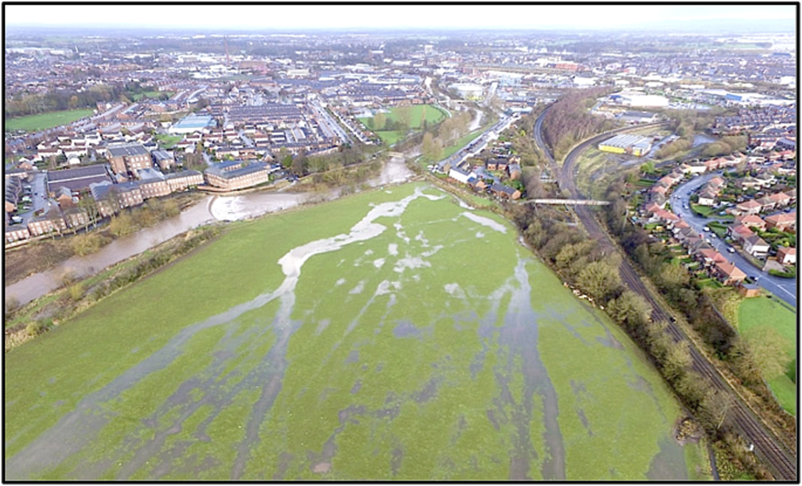
Morphophagia, terrain and territory
For present purposes, we make a conceptual distinction between ‘terrain’ and ‘territory’ (Figure 2), each with their systems of drivers and created forms. Terrain, or ‘t-natural’, is taken as being the form product of natural processes from the geological and hydrological to the ecological, as created over timescales and in events and episodes from single floods to decades, centuries and much longer. Such system dynamics are explored in the so-called natural sciences including geology, ecology and hydromorphology. Territory, ‘t-human’, by contrast, is taken here as landscape adapted by and for human occupation, notably as partitioned into owned property units with their constructions and the infrastructures connecting them. Beyond their construction technologies and architectures, these are largely studied within the humanities, including politics, economics and sociology. Whilst human/environment relations are affective for humans (Latimer and Miele, 2013; Werther et al., 2021), it is also true historically that this has worked the other way round. Increasingly there is now a human hardware element to the physicality of landscape. A conceptual representation of floodplain terrain forms (‘t-natural’) together with the conflicting processes of territory (‘t-human’). Consumption of the former (‘morphophagia’) results.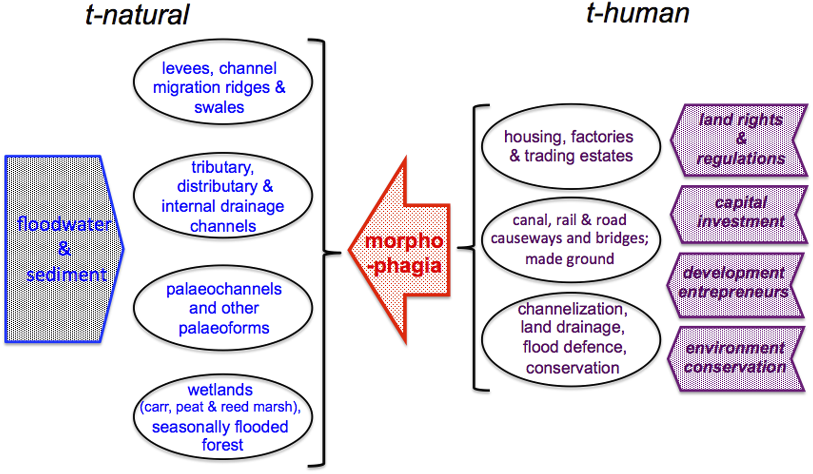
‘Territorialisation’ is used here for the human establishment of physical installations in bounded ownerships, but without going into the psychological aspects of human territorialisation or the weakening of ties between culture and place as seen in postmodernism and globalization (Deleuze and Guattari, 1980). But related social systems and the drivers of evolving physical capital investment, as associated with the trio of ‘power, profit and pleasure’ (Wootton, 2018), are embodied within modern socio-physical systems. As well as acting more generally as sources for the present ecological crisis (Guattari, 1989), these have instigated the ‘grounded’ process of terrain morphophagia. Territorial hierarchies cover a scale range from empires and states to local authorities and personal property, the territories discussed here being what Storey (2012) calls ‘micro-scale’. Physically they fit within the dimensions of floodplains or extend onto them, and of course higher-level actors (governments, local authorities, and trans-national and international businesses) also exert wider powers over what happens.
Epistemological issues
In the UK, any visitor contemplating the historically evolved landscape must deal with the ‘shock of the old’, to use David Edgerton’s phrase (Edgerton, 2019). What have been called entwined or hybrid morphologies have accumulated in contexts set by older social and physical forces, and historically-contingent spatial patterns have emerged. Although socially driven processes are here examined like other physically generative forcing episodes – such as Quaternary climatic phases or Holocene climatic oscillations (Gibbard and Lewin, 2016; Toonen et al., 2017; Macklin and Lewin, 2019) – the drivers themselves have been very different. We here employ collective ‘mid-range’ social mechanisms as outlined by Yeung (2019): time-framed ideological and economic perceptions; changing entrepreneurial motives; the timing of wealth generation and permissive financing; and empowering property ownership and juridical frameworks. Malm (2020, p.71) has observed that physical environmental destruction does not occur at the droplet or cloud level but at the level of society/nature interfaces, and comparable reasoning applies to the identity level of socio-physical forces used for present purposes.
Beyond usefully documenting socio-physical ‘incursions’, as pioneered by George Perkins Marsh (1801–1882), and as recently exemplified in contemporary terms for river channels at reach, catchment, national and global scales (Downs et al., 2013; Downs and Piégay, 2019; Hohensinner et al., 2013; Lewin, 2013; Macklin and Lewin, 2019), we put forward an explanatory framework for the socio-physical constructional transformations of floodplains. Like socio-ecological (Ekers and Prudham, 2015; Barton et al., 2016; Butler et al., 2021) and solely physical flooding/landform interactions (Foulds et al., 2014; Toonen et al., 2017; Blöschl et al., 2020), these involve internal levels of complexity, as do the elements of flood-responding alluvial architectures (Miall, 1996). But human and non-human alike, all involve episodic actions, non-linear dynamics, generating connections and forces from a distance, accumulative development, and emergent properties. To cite Moore (2015, p. 291), ‘There has been too little investigation of how bundles of human and non-human relations constitute modernity’s historic natures, and how patterns of power and capital are producers and products of these natures’. This echoes also David Harvey’s earlier concept of ‘socio-spatial fixing’: how accumulated capital moves into constructional use that then becomes physically anchored in particular territorial locations (Eckers and Prudham, 2015).
Floodplain forms have to date been explained by pulsed flooding and erosion/sedimentation events, episodes and phases: causative drivers then include erosion arising from upstream catchment land use change, small-scale high intensity precipitation cells, atmospheric moisture plumes, regional switches such as ENSO (El Niño/Southern Oscillation) or winter NAO (North Atlantic Oscillation), and now progressive global warming leading to variable monsoon and hurricane/typhoon intensities on a sub-continental scale (Aalto et al., 2003; Delile et al., 2013; Foulds et al., 2014; Toonen et al., 2017; Macklin and Lewin, 2019; Leli and Stevaux, 2022). Though with different timescales and via entirely different mechanisms, floodplain development from socio-physical drivers can be rationalized in a manner that is similarly episodic (DeLanda, 1997).
The history of UK floodplain incursions
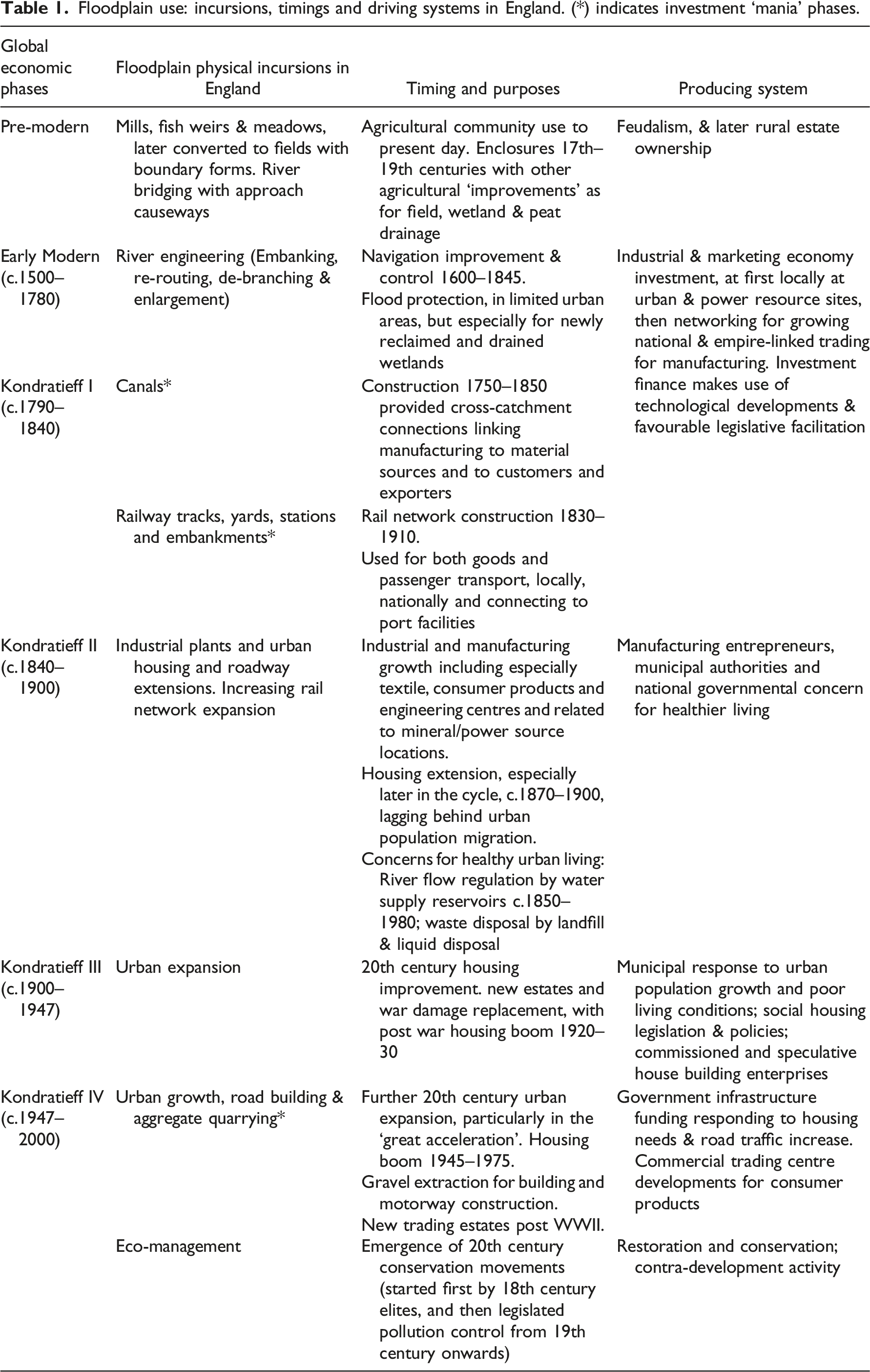
Floodplain use: incursions, timings and driving systems in England. (*) indicates investment ‘mania’ phases.
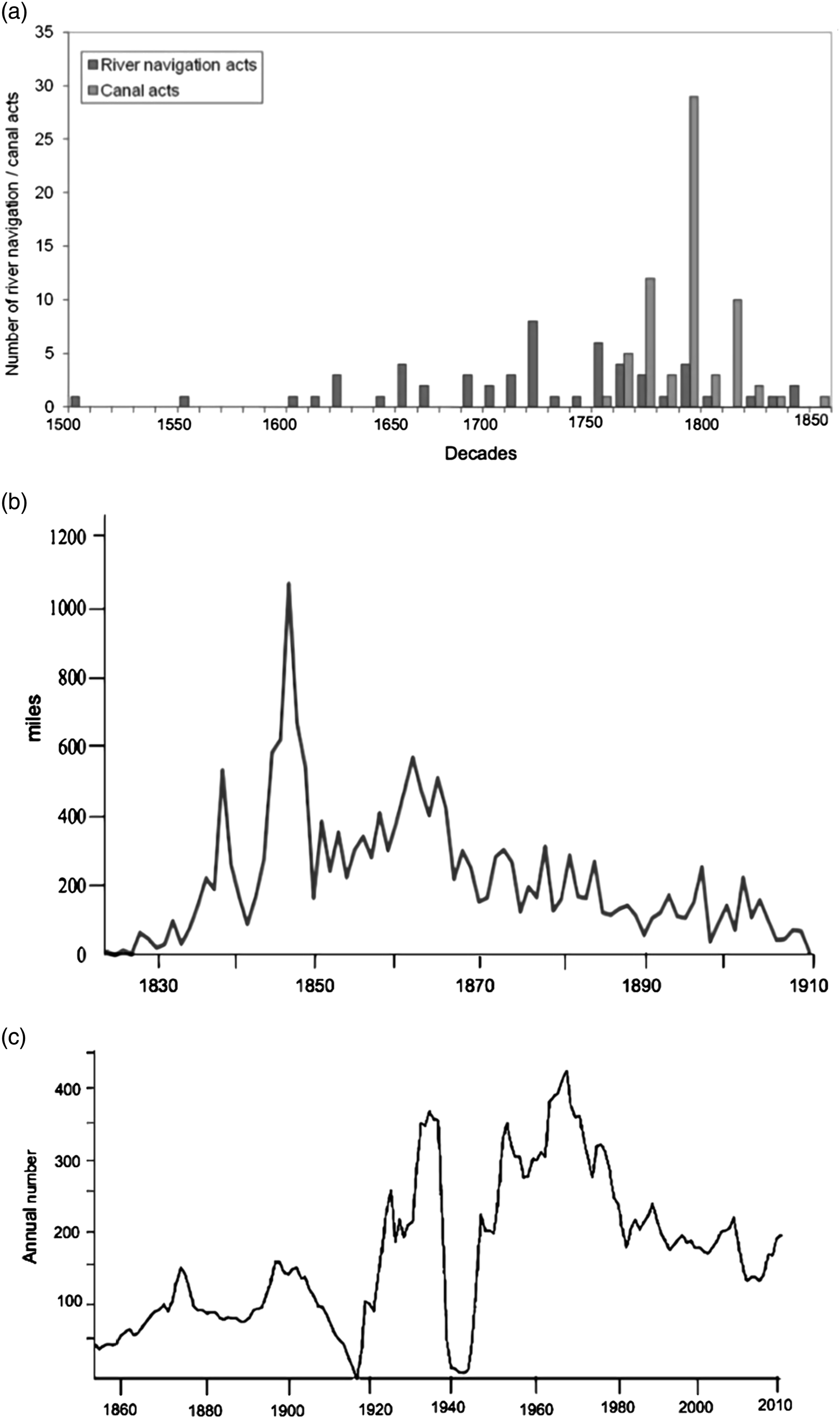
Cyclic patterns in developing the UK built environment: (A) British river navigations and canals, decadal Parliamentary Acts since 1500–1860 (from Lewin, 2013), (B) Annual British railway mileages constructed 1825–1911 (Shaw-Taylor and You, 2018), (C) UK house building, 1855–2010 (see Powell, 1996).
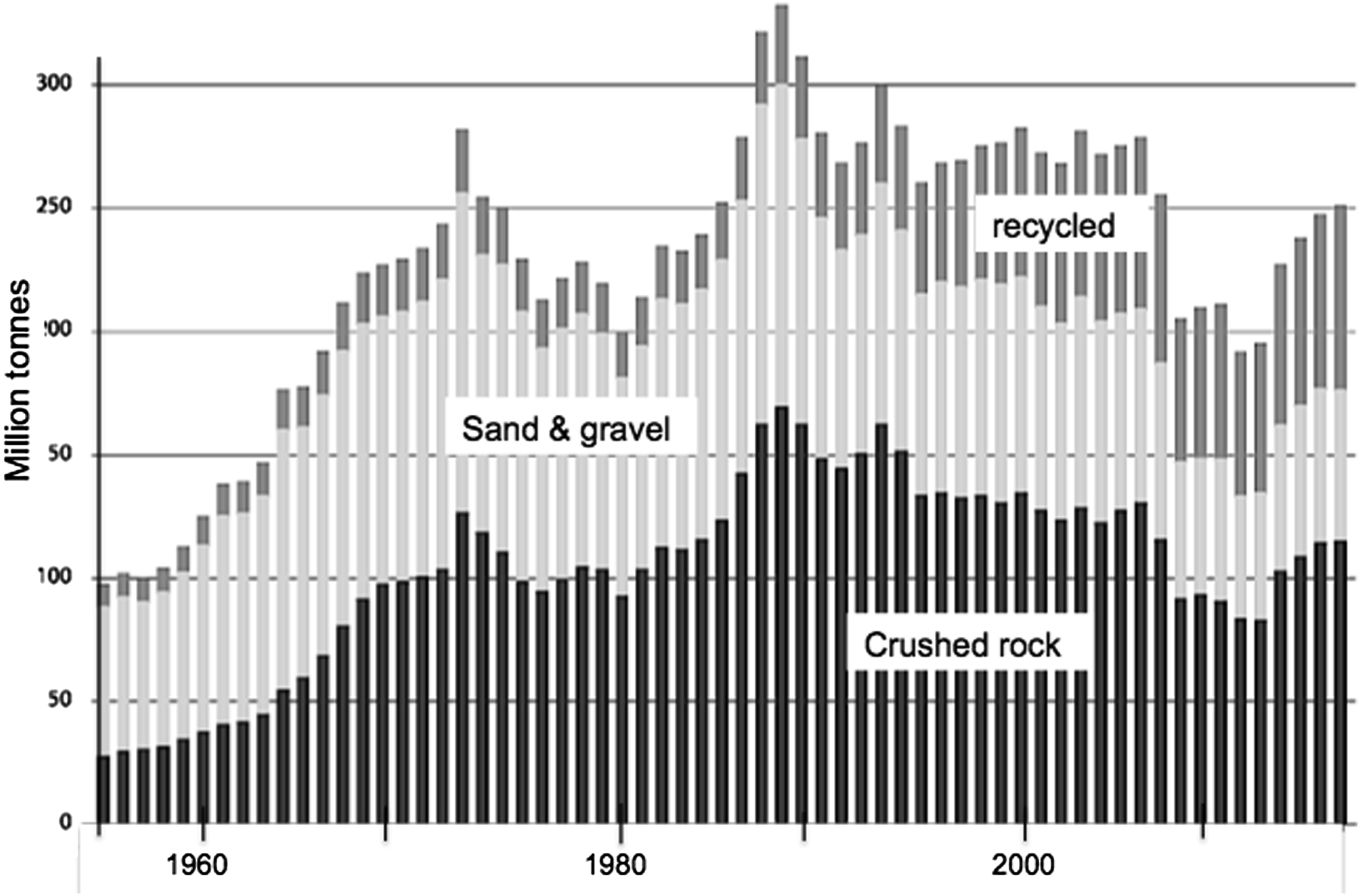
UK aggregate production, 1950–2017 (British Geological Survey data). This short time period covers the post-World War II ‘great acceleration’, particularly involving urban and industrial building, road construction and, for sand and gravel, the direct effects of alluvial extraction from floodplain sites.
After c.1500 CE in the UK, major engineering to improve river navigation largely preceded canal construction (Figure 3A), the latter with modal peak activity (or ‘mania’) at the end of the eighteenth century. A railway boom followed, notably with a manic period in the 1840s (Figure 3B). These three locally detached floodplains by erecting linear barriers to floodwater flow. Urban-industrial centres attracted in-migration, and infilling housing construction with linking road networks occurred across floodplains in the later nineteenth century, with further suburbanization after the two world wars of the twentieth century (Figure 3C). The increase globally in ‘anthropogenic mass’ (Elhacham et al., 2020) with its unprecedented material and energy use was then extreme in the period from the end of World War II. This is reflected in the use of construction material in the UK (Figure 4). All this meant a localised but incremental spread of built environment infilling laterally from transport lines – whether river, canal, railway or road. New housing later filled the gaps between prior structures, at first largely with straight Victorian/Edwardian terraces, but later by curving layouts with cul-de-sacs of semi-detached housing. Needed building aggregate came partly from gravel extraction from floodplains like those of the Thames, Trent, and Nene. These water-filled excavations were subsequently revalued as wildlife sanctuaries and for water sports, sport and recreation being another reason for some open-ground retention such as Worcester’s racecourse and Nottinghamshire’s Trent Bridge cricket ground.
All these developments followed each other in re-purposing floodplain land use, progressively modifying flood routing in the process. What may be called ‘sociometabolic transitions’ (Krausmann et al., 2008) have led to physical changes. After the Early Modern period in which bounded land ownership became largely set, development waves relate to Schumpeter’s four long-wave Kondratieff economic cycles (Lloyd-Jones and Lewis, 1998). Morphophagic cycles are conceptually summarized in Figure 5 as simplified pulses of initiation and extension, with subsequent form retention. Each phase involved capital investment purposed differently under changing economic and social values. Canals enabled increasing prosperity at the start of K I; railways also came early, setting off the second economic boom (K II). But housing was especially extended during the increasingly wealthy K III/K IV ‘peak-recession’ periods (distorted also by wars), with floodplains treated as a kind of abstract space with limited recognition of their distinctively hazardous nature as well as their locational advantage. This was to improve working lives with better housing, sanitation and health, & was made possible by economic growth. Trading estates, extending road transport and recreational needs (including water sports, playing fields, and nature reserves) as well as suburban housing has characterised the most recent consumption-led K IV prosperity/recession period, the so-called material ‘Great Acceleration’. With economic globalisation, this included a re-purposing of floodplain ‘brownfield’ industrial plant and defunct railway siding properties (as along the Sheffield Don floodplain) as storage and redistribution centres for global as well as national products. Each phase produced new structures, mostly as permanent incorporations into floodplain physical landscapes – but contingent upon contemporary property rights, a re-valuing of properties, capital wealth availability and the technologies newly available to entrepreneurs. (A) A simplified theoretical representation of floodplain development cycles in England; (B) intra-cyclic development phases leading to near-permanent floodplain structure retention or re-use; (C) the actual detail of peaks and troughs, with periodic intensities or development ‘manias’ (house construction taken from Figure 3C; compare also Figures 3 and 4).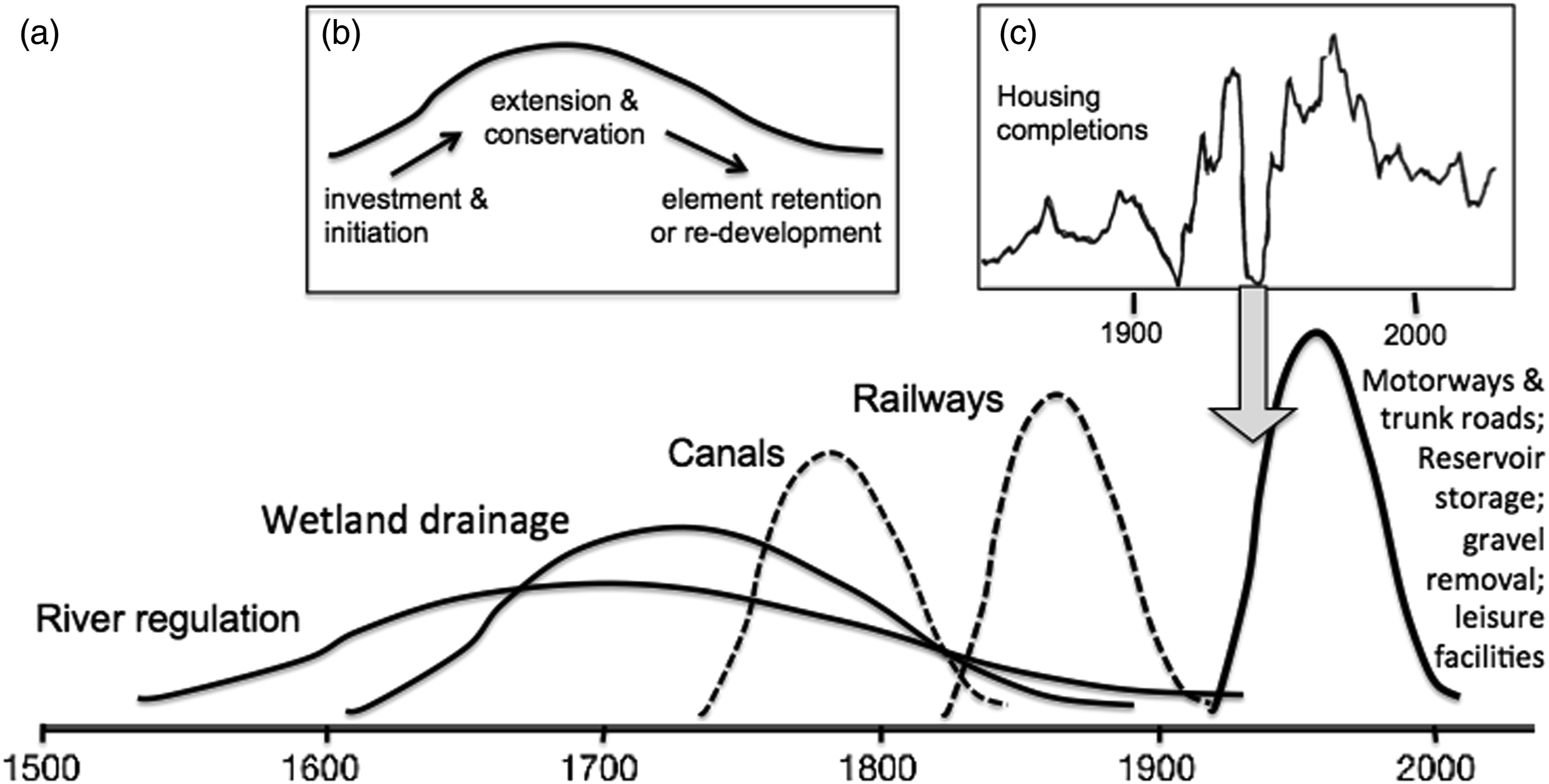
Land rights and values
Territories are anthropological or biological units that differ from the functioning and integrating hydromorphic ones of river catchments. Containing human barriers and patched developments disturb floodplain systems while non-local economic and political drivers impose controls on their invasive morphologies. Deleuze and Guattari (1980) thought of territorialization as a form of stagnation within otherwise fluid processes of human assembly. In a sense, this applies also physically to floodplain processes of water transfer and sedimentation that became ‘frozen out’ to prevent terrain processes acting naturally across developed land.
Within their social process units, land and water rights in England have a long and complex history (Getzler, 2004), but for present purposes may briefly be summarised as follows. By the Domesday survey (1086–7 CE), bounded feudal and manorial estates (held from the king who had dispossessed the entire population at the 1066 Conquest) were well set, with their value quantitatively expressed in terms such as hidage (area), population classes (freemen, villeins, bordars, slaves) ploughs, mills and fisheries (Williams and Martin, 1992). As Werther et al. (2021) have emphasised in central Europe, cultural history (with its bounded ground spaces) set the framework for later developments well before the industrial revolution.
In medieval and early modern times, floodplain terrains had intrinsic and distinctive human value for powering an essentially agricultural economy: directly as waterpower for mills, and indirectly via the meadowlands feeding livestock and the oxen that powered work on the land. In fenland border economies, wetlands had integrated and custom-set roles in local economies for food (fish, wildfowl), reed thatch and summer grazing (Oosthuizen, 2017). After the Black Death (from 1348 CE onwards), significant parts of the country transitioned from arable to sheep grazing, with the loss of traditional rights. The edge-defining enclosure of open fields and meadow took place, at first by individual landowners, and after 1604 by Acts of Parliament, including wastes and common floodplain meadows (Cook and Williamson, 1999). Ancient field boundaries (some of longer-standing than post-medieval) have determined the layout style of much subsequent ‘barrier and patch’ infilling. Settlement boundaries in some cases became impermeable, solid blocks of buildings and raised causeways were patched into the landscape, and together these have fragmented runoff systems or imposed new underdraining, ditch and culvert networks for the benefit of both agricultural land and settlements.
Further change involved massive reclamation of ‘wastelands unused’ (often major wetlands), a state viewed with moral disgust by elites in the seventeenth century (Di Palma, 2014). Fenland appropriation and drainage behind river embankments was instigated on a large scale by royal prerogative, often with local resistance and in conflict with common law (Ash, 2017; Boyce, 2020). Compartmentalization and draining of fen and floodplain increased, as in the Humberside levels, the Hull valley, Norfolk Broads, Lincolnshire and Cambridgeshire Fenlands, Somerset Moors and Levels, and coastal marshes as in Essex, Kent and Lancashire. This involved extensive channelization of rivers, the creation of rectilinear ditching systems, and installation of levee embankments and pumping stations (Ash, 2017; Darby, 1956; Williams, 1970). Some floodplains, amounting to c.40,500 ha, were also enhanced in value by being engineered as ‘floated’ (irrigated) water meadows (Cook and Williamson, 1999). But little urban encroachment occurred until the eighteenth century, bar bridges and arched approach causeways (Lewin, 2010).
Another and different phase followed with the industrial revolution when floodplains were again revalued on a broader scale as trans-local economic arteries for commodity trading (Figure 5): first by refashioning rivers, including with weirs and locks (especially c.1600–1840), and then by constructing both canals (c.1750–1840) and railways (1830–1910). National network extension grew by innumerable parliamentary acts that over-rode the frequent local opposition from landowners. It was the centralised permissive legislative power of parliament on a national scale that now facilitated entrepreneurial development across property ownership lines at these times, as for approving speculative railway schemes over local interests in the railway boom periods of the nineteenth century – in the event, whether economically viable or not (Ellis, 1954: pp.153–162). The sequestrating power of Parliament over-riding local land ownership to impose nation-wide development (like the extensive railway network) has now become more constrained through drawn-out planning processes, while corporate business power (often now foreign-owned) has become more general – again at the expense of local interests. It was also flood-liable lands next to expanding urban and industrial sites (including town commons) that was still ‘open’ for reconditioning use in the later nineteenth century, rather than other more valued peri-urban agricultural or ‘green’ sites – if inundation were discounted or was expected to be preventable.
Municipal and private property owners were nevertheless involved locally. Cities like Bristol sold off their common town marsh for building (there for Queen Square in 1699). In nearby Bath, the wealthy owner of American plantations Sir William Pulteney developed his marriage-derived estate with a half-kilometre causeway lined with speculative housing orthogonally across the Avon floodplain in the 1770s. Its cellars were promptly flooded. At Nottingham, following local government reform in the 1835 Municipal Corporation Act, the council fostered housing development on the burgess’s former floodplain common meadow conveniently ‘undeveloped’ right next to the town. Urban migration and poor living conditions in the later nineteenth century initiated over-riding and widespread social demands for housing, including on floodplain sites – still ‘free’ and revalued for the purpose. Such housing boom extension onto floodplains affected many urban centres, and then again following the wars of the twentieth (Powell, 1996).
Capital investments: sources and timings
Where did the necessary investment come from? Some was from post-medieval augmented agrarian production and wealth generation from aristocratic and gentry ownership of land, as from sheep farming and land holding expansion (Broadberry et al., 2015). Other investments came from ‘adventurers’ (who would now be called venture capitalists) like the 4th Earl of Bedford and his 12 associates draining the Fens from 1630 (Ash, 2017). Such projects were forms of internal appropriation and colonisation; later ones used capital from trans-global trading, including profit from shipping, plantation and slavery income from the Americas and looting from India (Barzewski, 2016; Sanghera, 2021). Other projects involved share issues by bodies like the directors of the Great Western Railway Company. Widening capital ownership gave profit-making opportunities through investing in transport innovation. For wealth sourced from the Americas, it is interesting to see from the UCL Legacies of British Slave-ownership project and database (
Agents of floodplain development
Commissioned entrepreneurs and agents actually directed the execution and layout of projects. These included Cornelius Vermuyden (1595–1677) for fenland drainage; civil engineers like William Jessop (1745–1814) continuing drainage work and executing a considerable number of river improvement schemes facilitating trans-national trade (Hadfield and Skempton, 1979); railway engineers like Isambard Kingdom Brunel (1806–1859) and Robert Stevenson (1772–1850), and the many housing master builders following in the footsteps of Thomas Cubitt (1788–1855). As Edgerton (2019) has emphasised, there has been a time lag between innovation inventions and their actual use, specifically in the case of railway engineering when the great development boom was driven decades later by a swarm of imitative market investment, this being when capital became available (Lloyd-Jones and Lewis, 1998).
Engineering and house building decisions largely determined alignments, building-block layout, and consequent overbank flooding restrictions. Many railway lines crossed rather than followed floodplains, often with impressive viaducts. Brunel’s Great Western line generally avoided floodplains except where necessary, as at Bath with long viaducts either side of the main station elevated above the Avon floodplain. Robert Stevenson, by contrast, rapidly and cheaply built the Northampton to Peterborough line on the floodplain of the Nene, involving 26 level crossings and 13 river bridges; it promptly flooded when built (Butler, 2006). The technological and manpower available to these construction agents changed considerably in the last 150 years, with mechanization and earth moving equipment replacing the large itinerant workforces (‘navvies’) for canals and railways, but involving other developing skills organised for house building (Powell, 1996).
Terrain into territory
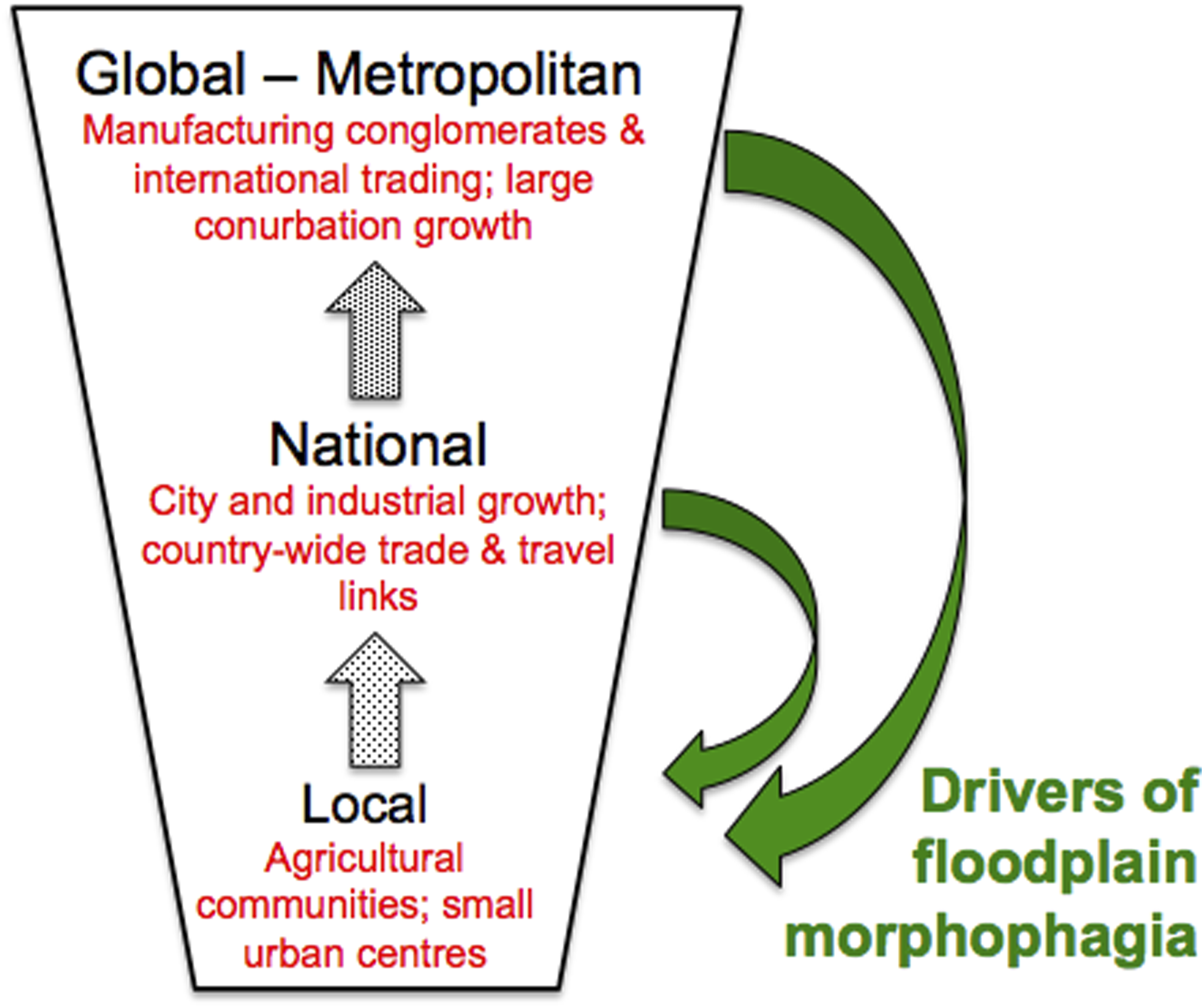
We have described a national process sequence broadly aligned with Immanuel Wallerstein’s Modern World-System (Wallerstein, 2004) with its transition from feudalism to capitalism followed by internationalization. Floodplains have been ‘radically restructured’ (Werther et al., 2021) in the Modern Era with the re-valuation of such land echoing the economic episodes of Wallerstein, Kondratieff and others (Rostow, 1975). On the ground this meant an infilling, stage by stage, of floodplain space as graphically set out in Figure 6. Also evident are the near-indelible physical results of upward power transfer within a changing capitalist system (Figure 7). Development episodes have lagged technological breakthroughs until investment-favourable times (Quinn and Turner, 2022). In an environmental context, UK development pulses have largely taken place following the Little Ice Age in a relatively quiescent environmental period before the present phase of accelerating climate change, although one still with infrequent extreme events (Blöschl et al., 2020). A spatial model of UK floodplain development. At first a medieval arched causeway from the town (A) was followed by isolated housing (B) along the approach; then Early Modern field enclosure, compartmentalizing the floodplain (C); and finally in Kondratieff phases housing estate/factory infilled the floodplain (D), ultimately with retrospective flood defences (E). The upward translation in time of power over territory, with feedbacks passing down locally to generate floodplain morphophagia.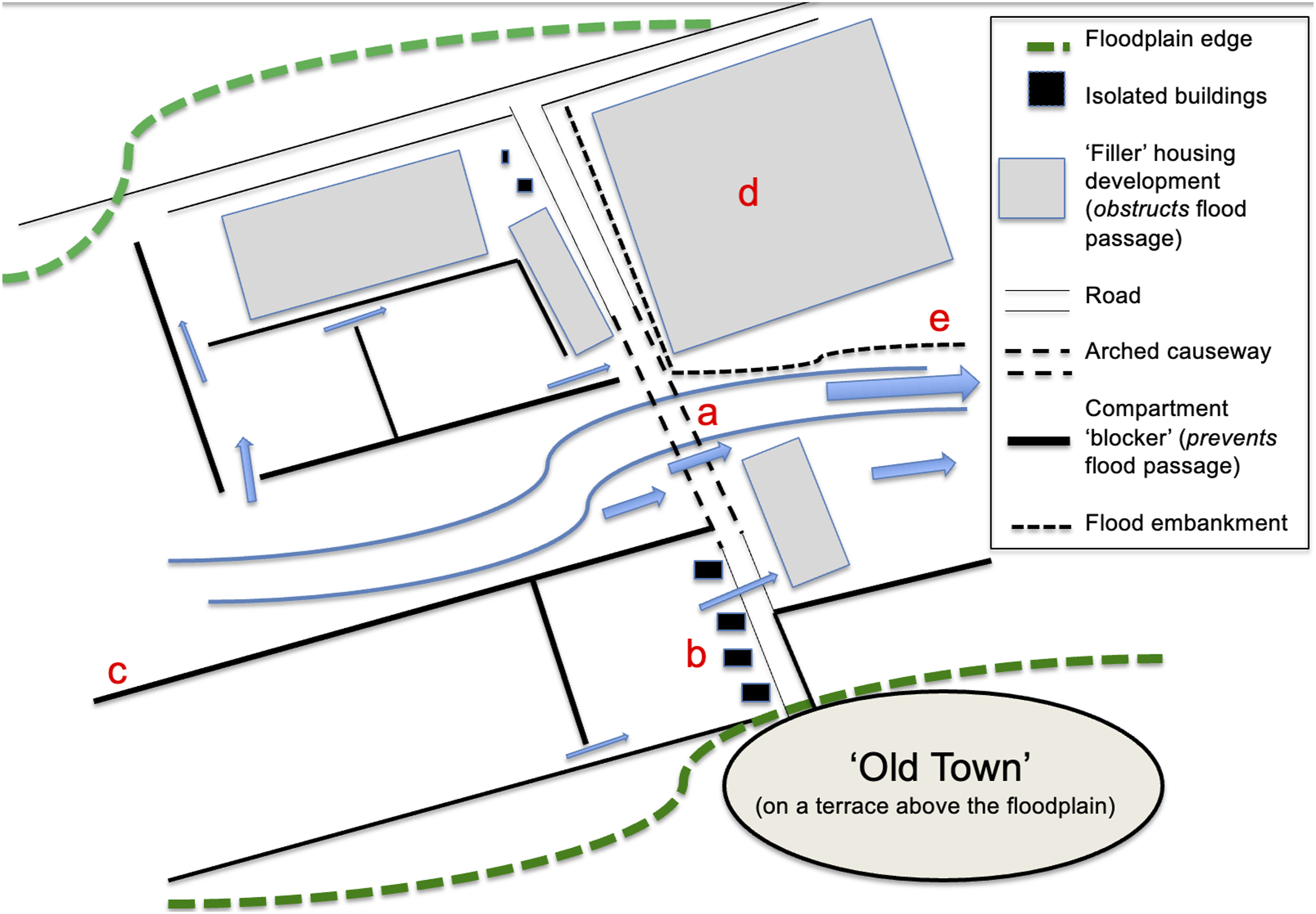
But as Moore (2011) has suggested, developments also reflect Marxist changing notions of value and of metabolic rift. The broad environmental decoding and recoding for the opposed values of capitalism (the sanctity of property and capital described in Section III above) has been characterized by an under-theorization of socio-physical environmental history. We here suggest that historical surges in floodplain development relate to periods when several drivers came into alignment: capital availability, land made available and novel technologies – but especially changing perceptions of value and consequent land re-purposing. For physical floodplain change, these became the mid-to late-modern socio-physical equivalent of explanatory drivers for naturally determined flood-rich periods and floodplain change (Lewin and Macklin, 2010; Toonen et al., 2017; Blöschl et al., 2020).
Unfortunately, the near-permanent physical inheritances from territorialisation episodes under capitalism now leave us ill-prepared for changing and unanticipated environmental dynamics that do not respond to short-term capitalist drivers (Guattari, 1989; DeLanda, 2006). Technocracies are, by their nature, ideological – centring also on the application of ‘scientific’ methods to social problems (Friedman, 2020). Coupled with a protection-of-value system that emphasises property and capital value, technocracies have tended to divide and ‘squeeze out’ adjunct social values, historic affiliations and environmental challenges that are deemed not to contribute towards, or add to, the capital or property values of their day. The extensions, or encroachments, of the environment (floods) into territories containing such emphasised values, whilst clearly influential, have been treated as circumstantial inconveniences.
Climate change is now beginning to have disastrous consequences, as constituting a likely contributor to flooding in Pakistan, Nigeria and southern Africa in 2022. A post-enlightenment development re-think in progress can be attributed to a re-valuation of the natural, and to phenomena such as levee failure disasters (Collenteur et al., 2015; Barendrecht et al., 2017). These illustrate a schism between the realities of terrain behaviour on the one hand and the unwary assumptions of the social values developed historically for territorial living on the other. In the UK, both the Early Modern and early Kondratieff phases valued intrinsic properties of floodplains (for river travel and power generation, as communication corridors, and for the agrarian resources of wetlands and meadow land). But later phases didn’t need, want or respect the natural properties of such terrain, and in effect aimed to eliminate and control much of it. It was territorial system needs (such as urban peripheral location and legal construction on land parcels) that came to dominate.
Flood hazard responsibility in the UK today is primarily expected retrospectively from controlled government funding, emergency services, engineered flood barriers and insurance. But the Pitt Review (2008), following the 2007 floods, and subsequent surveys (e.g., Bonfield, 2016; O’Donnell and Thorne, 2020; Jackson, 2021) have revealed the risky but unprepared state of many developments, and even the numerous emergency service facilities located in flood-liable sites. In adaptive cycle terms (Fath et al., 2015) applied here to human activities, resilience has in general been achieved through protection works only after floodplain exploitation and after destructive events have locally demonstrated needs. Despite what is known about flood hazard incidence and location, and now climate change, the Environment Agency also remarkably expects the number of English properties built on floodplains to almost double by 2065, whilst more than 5 m homes are now at risk of flooding (Environment Agency, 2019). For the Agency, financing maintenance let alone the upgrading of out-dated flood defences is a major challenge. The UK reflects the global picture where floodplain developments and consequent economic loses have increased and will continue to do so (Mazzoleni et al., 2020; Bates et al., 2022).
International comparisons
Across the world, there have been local studies of road and rail floodplain incursions (Li et al., 2005; Blanton and Marcus, 2014), levee effects in the context of floodplain restoration (Knox et al., 2022), and multi-element historical studies of river and floodplain detachment and transformation in the developed world (Arnaud-Fassetta et al., 2010; Downs et al., 2013; Hohensinner et al., 2013; Arnaud et al., 2019; Werther et al., 2021; Wilson, 2021). In Europe along the Danube, as revealed by the analysis of hydrological, historical and current geospatial data (Eder et al., 2022), floodplain detachment is considerable. Werther et al. (2021) suggest that 95% of central European floodplains have been ‘extensively restructured or destroyed’. In Europe, this relates back to medieval and preindustrial periods as well as to later happenings. This leaves such environments susceptible to unanticipated allogenic (allopoietic) changes under new flooding extremes.
Global timings and drivers for cascading morphophagic incursions have differed, with contrasts between industrialized and developing countries, the latter with dispersed floodplain communities focused on sustaining agriculture, some with high population densities and long-settled, others with lower densities and focused on the export of cash crops (Krausmann et al., 2008). Positive terrain valuations have outweighed the costs (or negative value) of inundation, and some agrarian civilizations have essentially required hazardous floodplain occupation despite the loss of life and property. Globally, urbanisation of floodplains appears almost to have doubled since 1985, with actual rates increasing after 2000 (Andreadis et al., 2022). In complete (if uncommon) contrast, Ivanov et al. (2022) report a massive abandonment in the late 20th Century of land long under agricultural use along the River Ob floodplain in Western Siberia. Any emerging global picture is not going to be a simple one.
Annually flood-affected and total national populations in 1950 and 2020.
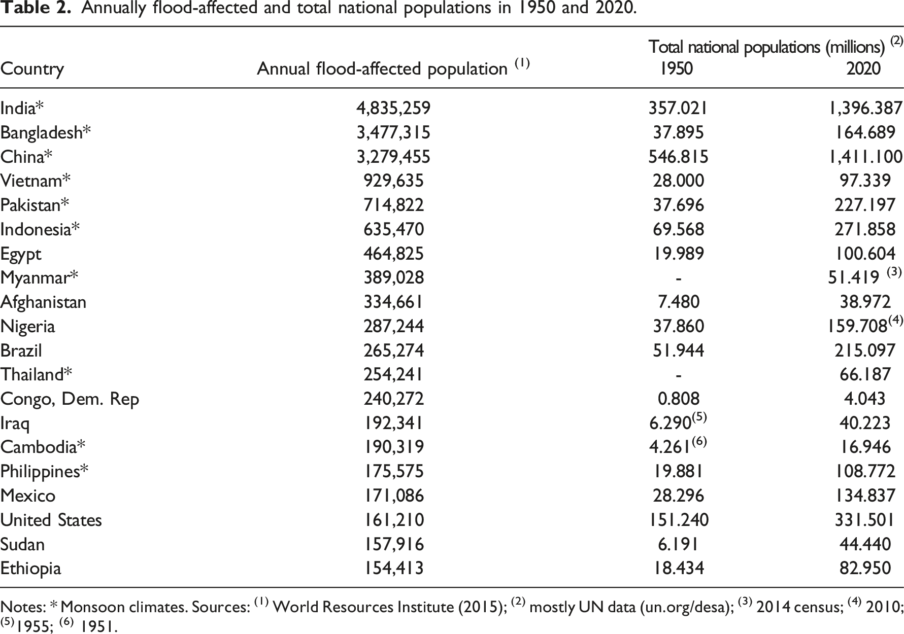
Notes: * Monsoon climates. Sources: (1) World Resources Institute (2015); (2) mostly UN data (un.org/desa); (3) 2014 census; (4) 2010; (5)1955; (6) 1951.
Thus, while the UK shares many characteristics with other European states, drivers have been different elsewhere, and differently timed (Krausmann et al., 2008). The particularities of place and time are crucial for any comprehensive and global understanding of floodplain territorialization and incremental transformation. We need to recognise why, when and how serial floodplain morphophagia has extended, and how, set within preceding activities, this has responded globally to social factors in different patterns than those outlined in Table 1 and sections 3.1–3.3 above. UK experiences do not provide a globally applicable template, but rather support the case for local understandings of what lay behind socio-physical floodplain transformations – from which lessons, and future actions, may come.
Discussion and conclusions
For the last several hundred years in the UK, we have outlined a phased accumulative progression in socio-physical construction. Locally-focused floodplain use for power and provisioning has been followed by speculative investment for extensive wetland drainage and reclamation, and then to terrain revalued as communication corridors to satisfy national economic drivers (in K I, with transport connections and the urban expansion of work-supported communities, some living on floodplains, and some of these clustered along confined valleys). Urban-centred industrial growth, especially from K II onwards, was locally driven and accompanied by urgent housing needs. Floodplains became valued simply as free land space. Finally (K IV) there has been some further floodplain re-evaluation for fragmented quasi-natural ‘reserves’ and for open-air recreational purposes. Layouts demonstrate historical contingency, with new developments inserted between older ones. The same is true of other global locations, though differently, and there is a need to further document and explain widespread episodic but cumulative floodplain impacts as set historically elsewhere.
The hydrosystem manipulations of history, some intentional and others not, have bequeathed vulnerable structures and unreasoned expectations of safeness. Capitalism & its phases since the Middle Ages in the UK exhibited minimal regard for full environmental functioning (of which floodplains are a natural part) and until late in the nineteenth century paid little enlightened attention to environmental degradation other than in the aesthetic-redesigned estates of the elite. The intrinsic value of floodplain terrain, recognised specifically as floodplain, has been largely replaced by the values of territory. Terrain has been modified into territory at will – with instrumental power moving upwards, and in response to wider-ranging socio-economic drivers.
But developments have avoided the long-term consequences and costs for the installation, maintenance and improvement of security measures. At some level, state, community and individual actors have had repeatedly to deal with these retrospectively and largely by engineering means. From the enlightenment onwards, this is rather than planned behavioural syntheses that avoid setting people, property and activities in harm’s way. By changing focus, recognising river catchment terrain processes jointly with those expected in territories, we might conceive of an improved, less adversarial, but necessarily co-existent future (Lane et al., 2010; O’Donnell and Thorne, 2020). There are the beginnings of another re-valuation of river valleys as ‘blue green corridors’ for both ecological and human health benefits (Thorne, 2020) with a ‘behavioural turn’ in progress (Kuhlicke et al., 2020). In the UK ‘making space for water’ (Defra, 2005) surely must continue to mean what it says – and to be planned for, with a better-organised and educated community of purpose that hasn’t previously existed. Whilst this is realistically possible in countries such as the UK, the developing and likely overwhelming scale of flooding and vastly increasing urban and rural floodplain populations, as in southern and eastern Asia (Fang et al., 2018; Tellman et al., 2021; Renschler et al., 2022), makes this extremely difficult.
Physical emancipation from the past is not practicable, but coming environmental changes do need to be more strongly accommodated alongside other means for achieving healthy economies and societies. A great deal about floodplain development, its security and global differentiation remains unknown: also available unused is ‘knowledge in the dark’ (Jeschke et al., 2019), and a public conversation is needed on what is and isn’t known. If the natures of both t-human and t-natural process systems, co-occurring in the same physical space, are equally understood, with avoidance as much as possible of hazardous sites, then both may be better managed to face future extremes without the previous insouciant developments we have outlined. In such ways, long-term DRR (Disaster Risk Reduction) and SDG (Sustainability Development Goal) objectives may be achievable in the UK, if not so readily globally (United Nations, 2020; O’Shea et al., in press).
Footnotes
Acknowledgments
We thank Professor Paul Bates, Dr Jeff Neal and colleagues in the University of Bristol, School of Geographical Sciences Hydrology Group, for help and support in developing the concepts in this paper.
Declaration of conflicting interests
The author(s) declared no potential conflicts of interest with respect to the research, authorship, and/or publication of this article.
Funding
The author(s) received no financial support for the research, authorship, and/or publication of this article.