
Abstract
Natural flood management (NFM), or working with natural processes, is a growing flood risk management method in the UK, Europe and worldwide. However, unlike the current dominant technical flood management, it lacks an established evidence base of flood risk parameters. This lack of evidence base can limit the uptake of NFM as a flood management method. This paper critically evaluates examples of NFM and wider relevant literature in order to identify NFM knowledge gaps and suggest how to overcome these. The UK is used as a microcosm of different environments for diverse examples. The sections include: land cover, land management, landscape interactions and trade-offs, evaluating the wider benefits of NFM and, finally, scaling from plot to catchment. This concludes in a suggested framework for a new approach to NFM research, which encompasses spatial scales, interactions and trade-offs of NFM and consistency of reporting results. Widening the NFM empirical evidence base should be seen as an opportunity for a new approach to flood research through exploring new habitats and new flood resilience methods.
I Introduction
Flooding is the result of intricate relationships between weather and catchment characteristics. The hydrological cycle is highly sensitive to changes in landscape and climate, and there is plentiful evidence that hydrological processes are being impacted by climate change, and by landscape modification such as deforestation and urbanisation (IPCC, 2013; Min et al., 2011), with the effect of increasing flood frequency and magnitude (Evans et al., 2006; O’Connell et al., 2007; Wheater and Evans, 2009).
White (1942) was the first to state that a society becomes modern when it accepts that risk cannot be eliminated but is a probability that must be confronted. Such a statement is true of the shift in flood management within the UK and Europe, where since the 1990s it has been accepted that flood risk cannot be eradicated through defensive structures put in place through technical flood management (TFM). Ideally, flooding would be treated as a natural process that should be accepted and mitigated accordingly at all spatial scales within a catchment (Tunstall et al., 2004). This principle of acceptance and mitigation underpins natural flood management (NFM) approaches. Whilst multiple definitions of NFM exist (see Ball et al., 2013; Bracken et al., 2016; McLean et al., 2013), a definition is used herein which combines those from the Scottish Environment Protection Agency (SEPA, 2015) and the Environment Agency (2010): NFM aims to reduce flood risk by protecting, restoring and emulating the natural hydrological and morphological processes, features and characteristics of catchments using environmentally sensitive and beneficial techniques to manage sources and flow pathways of flood waters.
NFM can be classified into four broad categories, which operate across the upper, middle and lower catchment: the storage of water in the landscape, increasing water infiltration, slowing the flow of water and reducing hydrological connectivity within the landscape (Pescott and Wentworth, 2011). Detailed descriptions of the types and benefits of NFM have been summarised in previous publications and, therefore, are not the focus of this paper (see Burgess-Gamble et al., 2017; Cook et al., 2016; Dadson et al., 2017; Iacob et al., 2014; Rogger et al., 2017), but can include approaches as diverse as the use of beavers to reduce river connectivity (Puttock et al., 2017), restoring peatlands (Holden et al., 2008) or reintroducing river meanders (Mathias Kondolf, 2006).
In contrast, TFM currently dominates flood management within the UK and Europe (Butler and Pidgeon, 2011; Cook et al., 2016; Johnson and Priest, 2008; Meyer et al., 2012; Plate, 2002). TFM typically directs the flow of flood water away from the area at risk through structural defences such as flood walls, dams, raised embankments and levees. This approach has historically been employed in response to major floods, particularly when there is public demand for an immediate response (Butler and Pidgeon, 2011).
The current UK TFM strategy is insufficient to address complex catchment issues in a changing climate (Tunstall et al., 2004). Installation of structures is often a fragmented response to flood risk management, only considering the immediate risk area and giving little consideration to wider catchment implications and smaller floods, such as the rapid redirection of flood water to another area causing secondary flooding (Demeritt and Nobert, 2014). Engineered structures carry a high financial cost; two thirds of the UK flood mitigation budget is spent upon river and coastal defence maintenance. Structures can fail as flood frequency and magnitude increases with climate change (e.g. dam failures or flood wall breaches) and structures typically only provide the benefit of flood risk reduction with few other environmental benefits (Ligon et al., 1995). Evidently, TFM alone is inadequate in reducing flood risks across a whole catchment (Bracken et al., 2016).
TFM support is maintained by an established evidence base of physical processes and numerous case studies across differing environments. NFM currently lacks a similar, robust empirical evidence base describing the impact of NFM upon flood risk parameters, including before and after impact measurements. Such an evidence base is needed to enhance confidence in implementing NFM measures (Table 1) (Cook et al., 2016; Iacob et al., 2017; McLean et al., 2013; Waylen et al., 2017). The aim of this review is, therefore, to critically review new approaches for NFM progression through a series of evaluations of NFM interventions. This includes: (1) land cover and management, which is currently poorly understood; (2) landscape interactions and trade-offs; (3) wider benefits of NFM; and, finally, (4) scaling of NFM interventions from plot to catchment. The review concludes with a proposed research framework through which knowledge of multiple NFM-relevant parameters can be evaluated, thereby creating an empirical baseline for NFM decisions, which may support wider implementation of NFM to manage flood risk.
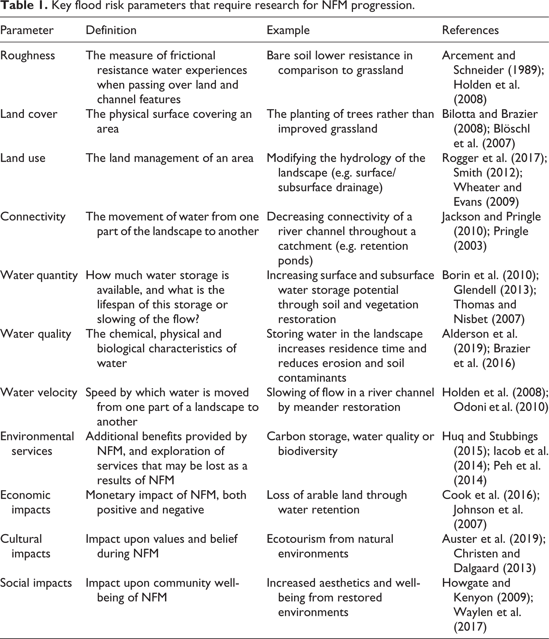
Key flood risk parameters that require research for NFM progression.
II Land cover and land management
1 Woodland
In spite of the reasonably widespread deployment of NFM approaches (Burgess-Gamble et al., 2017), the evidence base of land cover is still in development. However, some approaches to alter hydrological process within different land covers have been studied in more detail. Woodland restoration (including riparian, cross slope and floodplain reforestation) is a highly cited NFM strategy with a fundamental belief that trees may intercept overland flow and increase hydraulic roughness, infiltration and soil water-holding capacity (Bradshaw et al., 2007; Thomas and Nisbet, 2007) (Figure 1). Since 1959, Manning’s roughness coefficient for woodland has been set to five times higher than grassland (typically 0.03 versus 1.50), underpinning countless hydrological response models since (Chow, 1959). Small- or medium-sized field studies have demonstrated woodland effectiveness as a popular form of NFM. Examples include the planting of trees and reduced stocking density in 12 m × 12 m plots of the upper catchment of Pontbren, Wales, which reduced surface runoff by 78% (Marshall et al., 2014; Wynne-Jones, 2016). In the soil erosion literature, woodland plot experiments have shown wooded plots with minimal disturbance produce less runoff than control plots of grassland (Ludwig et al., 2005; Pierson et al., 2014; Wilcox et al., 2003). Through studies such as these examples based upon fundamental woodland process understanding, woodland restoration has become an accepted NFM strategy. What we lack is quantification of how these processes operate in different catchment conditions, with climate change trajectories and, therefore, the potential catchment-wide impact of woodland restoration.

Wet woodland after a rainfall event restored to provide natural water storage (source: author’s own).
Thus, caution must be taken when implementing woodland planting as an NFM strategy based upon existing studies. Conflicting evidence is available, such as the weak relationship found between flood frequency and natural forest cover by Bradshaw et al. (2007) across 56 countries, which shows that even well-forested areas can still be sources of flooding. In addition, Soulsby et al. (2017) found in winter 2015/2016 there was increased saturation excess runoff despite woodland presence on the River Dee, Scotland, due to saturated conditions from preceding storms. Stratford et al. (2017) acknowledge that the impact of tree planting upon flood peaks is often mixed and significant in smaller floods but less so in larger floods. Also, as Connelly et al. (2020) state, the majority of woodland evidence reviews are UK-based; therefore, research needs to expand to a wider array of international studies of different woodlands (e.g. Leyer et al., 2012).
To some extent, modelling work has been deployed to bridge the gap between our limited empirical understanding of woodland NFM and the landscape-scale knowledge of potential flood risk reduction that is needed (Odoni et al., 2010; Thomas and Nisbet, 2016). Therefore, the conclusion that woodlands can reduce flood peaks with catchment-scale restoration is primarily based upon modelling and not field observations (Stratford et al., 2017). For example, Thomas and Nisbet’s (2007) use of one-dimensional (1D) and two-dimensional (2D) models concluded the addition of a 50 ha woodland block on 82km2 of the River Parrett in southwest England could decrease river velocity in a 1% annual probability event. While such modelling is a valuable tool, it is currently poorly validated, and, even at the plot scale, results comparing NFM model predictions and observations are inconsistent (Birkinshaw et al., 2014; McIntyre et al., 2012). Thus, empirical data or monitoring studies of woodland are needed to validate models, and a stronger dialogue is vital between field observations and modelling studies than currently exists.
There is also a clear need for catchment-scale woodland restoration in medium to larger catchments, with comprehensive flow monitoring to understand dominant woodland processes which govern runoff (Thomas and Nisbet, 2007). The process-based data can then be used to validate models and reduce uncertainties. In addition, to account for changes in land use, weather and measurement accuracy (Birkinshaw et al., 2014), the use of a before-after-control-impact (BACI) framework would be beneficial (Nyssen et al., 2011). Where mature woodland is being studied, paired plots of landscapes with similar characteristics may be a viable alternative. This would include studying the impact of soil (e.g. hydrological properties and antecedent conditions), tree type (deciduous versus coniferous), tree lifespan (e.g. time from planting to become effective, vegetation succession) and woodland management. Through multiple experiments it would then be possible to build large-scale evidence of NFM impacts on flood risk parameters (Table 1). Finally, with growing interest in reforestation and the potential for observations to quantify change, the framework for reporting results needs to be consistent for comparison, including acknowledging both model and field-based uncertainties. This is especially vital when the contribution of individual NFM interventions to the overall hydrological response may be modest, until the full suite of NFM techniques implemented at catchment-scales are considered.
2 Grasslands
Whilst the fundamentals of woodland NFM are becoming established in practice and there has been some integration of woodland restoration in flood modelling, there are other common land uses that are poorly understood for their NFM potential (or potential to cause flooding). Grasslands are a good example of this, particularly in the UK where grassland accounts for 40.5% of the landscape and 70% of agriculture (Silva et al., 2008). Improved grassland has conventionally been classified as exhibiting low hydraulic roughness according to roughness coefficients such as Manning’s N values (Arcement and Schneider, 1989). It is now recognised that improved grasslands, typified by monocultures of Rye grass, are indeed sources of enhanced overland flow, limited water-holding capacity and erosional processes under poor management, due to high levels of compaction (and, subsequently, low infiltration and through flow) and low hydraulic roughness (Bilotta et al., 2008; Brazier et al., 2007; Pilgrim et al., 2010). These assumptions form the basis of many physically based catchment-scale models (see Bilotta et al., 2010; Dadson et al., 2017; Metcalfe et al., 2015). Yet, it is important to recognise that not all grasslands behave in this way and that the land cover of grassland can be more diverse ecologically and hydrologically.
Grassland hydrological behaviour can be altered by the presence of subsurface drainage. The aim behind drainage is to increase potential soil storage capacity by removing excess surface water, thus potentially decreasing overland flow (Armstrong and Garwood, 1991; Needelman et al., 2007). However, research by Bilotta et al. (2008) showed that sediment erosion driven by both runoff and subsurface flow from drained fields was significantly higher than control sites where no drainage was present. Water draining rapidly from grasslands may, in fact, result in more rapid transfer to the river system and, therefore, contribute to downstream fluvial flooding. This calls into question how much water improved grassland can store with the correct management of drainage. Research by Bilotta et al. (2008) demonstrates that improved grassland should no longer be treated as exhibiting just one type of hydrological response and requires research into land management impacts to be reflected within future modelling. Flood and landscape managers should invest in research such as the monitoring of parallel fields of different management styles (e.g. drained versus undrained grasslands) being assessed for runoff to determine the most beneficial form of management for NFM in that area, as opposed to the best management for agricultural productivity.
Of course, improved grassland can be reverted to unimproved grassland, whether this be in field margins or the whole field, with significant environmental and ecological benefits. Unimproved grasslands constitute 2% of UK grassland cover, but are highly species diverse with low-intensity agriculture in comparison to improved grassland (Blakesley and Buckley, 2016). Sward extent of unimproved grasslands have been reduced by 97% since 1930 with agricultural improvement (Critchley et al., 2004; Manchester et al., 1999). Unimproved grasslands are, therefore, valued for biodiversity, but are only just being understood in terms of their potential hydrological benefits. For example, Puttock and Brazier (2014) concluded rush pasture and Molinia Caerulea (known as Culm grassland, or Rhôs pasture more widely in northwest Europe) stored more water within the surface and subsurface than intensively managed, improved grassland due to surface pooling within grass tussocks and high soil water-holding capacity (Figure 2). Other publications have alluded to potential hydrological benefits from the hydraulic roughness and improved soil conditions associated with unimproved grasslands (Critchley et al., 2004; Haygarth et al., 1998; Humphreys et al., 2013). Unimproved grassland is, therefore, an example of a land cover that lacks the hydrological baseline understanding of improved grasslands or woodlands, which subsequently informs model inputs, land management decisions and NFM potential. Further investigation is thus required of minority vegetation (such as unimproved grassland) so that hydrological properties including water storage can be quantified, better parameterised and, therefore, modelled as NFM components of the wider landscape.

Molinia caerulea tussocks in north Devon, UK, providing surface water storage after a high rainfall event (source: author’s own).
3 Soil management
Even in areas of constant land cover over space and time, hydrological function can be altered over space and time by land management practices (Hess et al., 2010). Soil is a vital component of the landscape and central to NFM schemes including soil aeration, sub-soiling and increasing soil organic matter. This is based on fundamental soil property literature; by restoring soil properties, soil infiltration and water storage, floods can be alleviated (Vereecken et al., 2015). For example, soil aeration and subsoiling has been suggested to reduce soil compaction and increase organic matter accumulation (Lal, 2001; Wallace and Chappell, 2020). In practice, the results of soil management vary significantly in trials with factors such as land use, soil type and slope. Smith (2012) reported the impact of soil aeration experiments ranged from insignificant to a 100% increase in water storage and runoff delay. Curran Cournane et al. (2011) found no differences between aerated soils and control plots in cattle-grazed pasture with a poorly structured silt-loam soil. Yet, experiments reported by Franklin et al. (2007) demonstrate the value of soil management, when soil aeration decreased surface runoff in well-drained soils by 35% in comparison to previous conditions. However, Franklin et al. (2007) also found poorly drained aerated soils increased soil runoff compared to non-aerated soils, thus demonstrating the importance of the effects of different soil series on runoff generation. With such varied results, evidence suggests the range of soil properties need evaluating in regard to soil degradation and subsequent management. This includes poorly understood soils, such as the chalk soils of south England or peatlands (e.g. Netherlands, Finland and north England) (Hodnet and Bell, 1990; Holden et al., 2006). There is little research on the role of soils within NFM (particularly in the UK), and conflicting results of pilot studies such as those above show that more quantitative knowledge on the mechanisms that soil management might deliver via NFM. Further research might address knowledge gaps relating to social acceptance of NFM and economic drivers for NFM via approaches such as soil management (see Wingfield et al., 2019).
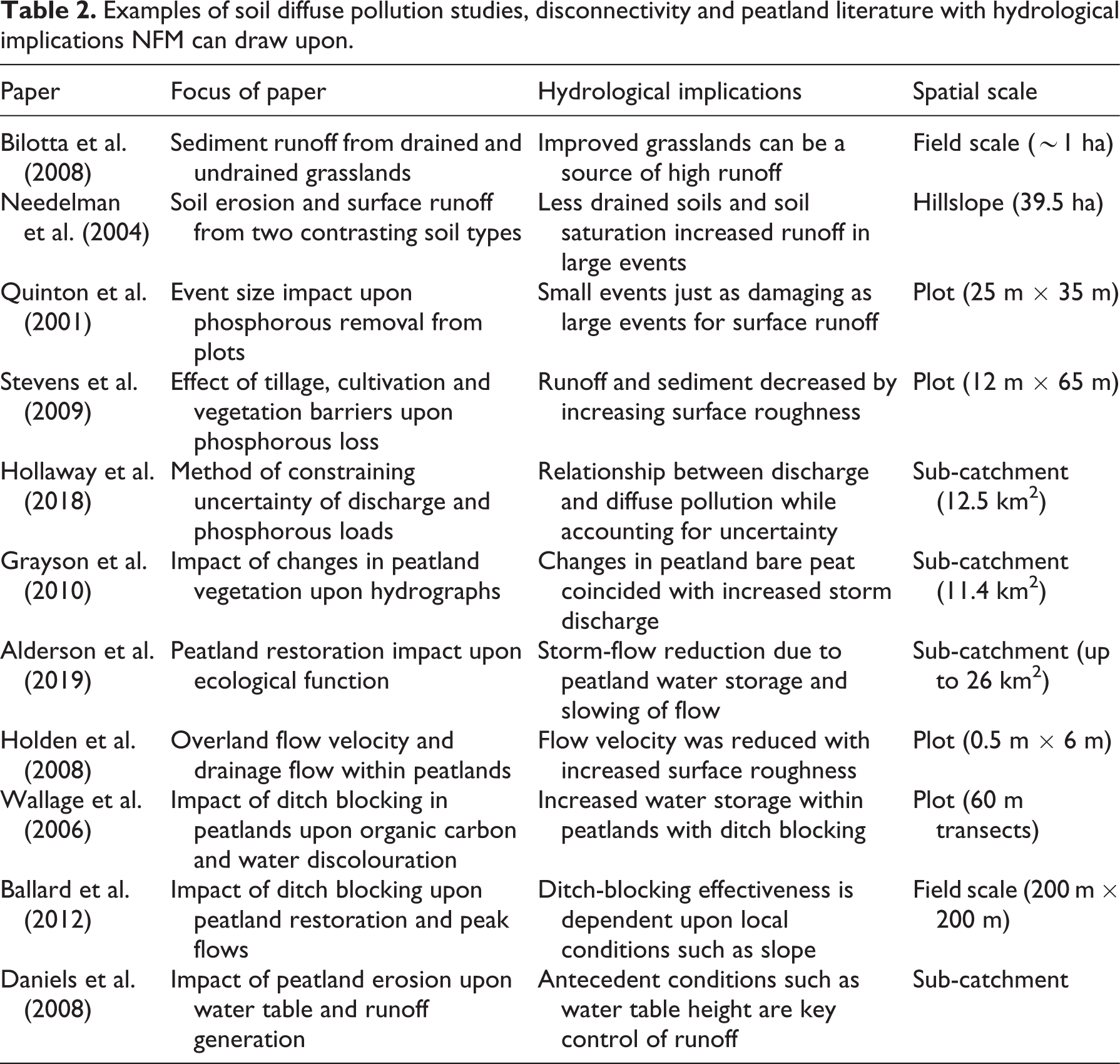
Evidence of soil hydrological properties is available within research outside NFM, or, indeed, hydrological studies – namely, within soil erosion and diffuse pollutant transport research. Typically, data describing soil water response to different interventions can be found. Multiple studies of phosphorus loss and soil erosion from agricultural management techniques also draw upon measurement of runoff mechanisms which transport pollutants. For instance, a study of comparisons between minimal tillage, contour cultivation and vegetation barriers concluded that phosphorus loss was reduced by the management techniques that improved surface roughness, which was a direct control upon surface runoff rates within fields (Stevens et al., 2009). Other experiments have found relationships between rainfall/runoff event size and removal of sediment from plots, including Quinton et al. (2001) and Bilotta et al. (2010), who found that phosphorus and sediment loss increased with increased peak discharge. Research described by Hollaway et al. (2018) and Bilotta et al. (2010) has even explored river discharge and catchment-scale changes upon pollutant transport, an omission for which NFM research is criticised. There is a lack of soil hydrology knowledge within NFM, but expanding into the wealth of knowledge available within diffuse pollution and soil erosion studies may aid NFM research alongside new studies (as exemplified in Table 2).
Examples of soil diffuse pollution studies, disconnectivity and peatland literature with hydrological implications NFM can draw upon.
4 Drainage of intensively farmed agricultural land
The surface drainage of soils as a land management technique involving the maintenance of field-side ditches has shown contrasting results within NFM research. Historically, such drainage has been a widely used land management technique to increase land productivity (Needelman et al., 2007) and, indeed, such drainage prevails across the majority of intensively farmed landscapes. The core concept is to lower the water table to keep soils dry; however, this accelerates the movement of water to the river (Bilotta et al., 2008). Evidence regarding flood risk management by disrupting such drainage is limited and confined to headwaters. Research suggests that modifying ditches themselves may reduce flood impacts and diffuse pollution, via ditch widening or increasing surface roughness through the reintroduction of appropriate riparian vegetation (Holden et al., 2006).
Model predictions of ditch widening and increasing within-ditch roughness both show decreased and delayed hydrograph peaks within one-in-20- and one-in-25-year events at Nafferton Farm, County Durham (Jonczyk et al., 2008; Kutija and Murray, 2007), illustrating the potential for field-side ditches to slow flow or be used to capture water within the field rather than rapidly divert water from the field. For instance, studies such as Wilkinson et al. (2014) and Ockenden et al. (2014) suggest open boundary ditches may be used for sediment and phosphorus capture, and, therefore, also runoff capture. A sandy wetland site captured 70 tonnes of sediment over three years in Cumbria, with significantly slowed flow (Ockenden et al., 2014). This finding could easily be translated to provide additional confidence in NFM interventions, where the field-scale benefits from surface water storage manifest alongside sediment and nutrient capture. Evidence of the value of drainage modification needs to progress to field trials across a range of land uses and management, as drainage is so commonplace within the intensively farmed world that it is a resource that, if altered, may prove hugely beneficial in terms of NFM.
5 Drainage of extensively farmed uplands and peatlands
Restoration through ditch blocking in catchment headwaters may deliver NFM benefits. Using a conceptual model, ecosystem services provided by the restoration of peatlands, including enhanced water storage, and the potential to slow the flow by ditch blocking, were assessed by Grand-Clement et al. (2013). Similarly, Alderson et al. (2019) and Shuttleworth et al. (2019) found that the restoration of bare peatland led to storm discharge reduction. Alongside the multiple environmental benefits of habitat restoration, the blocking of ditches raised the water table and reduced connectivity as well as increasing base flow, all factors which deliver NFM. Methods do not even have to be human-based, as multiple beaver reintroduction studies across Europe and North America have proven when beaver dams raise water tables and store water (Nyssen et al., 2011; Puttock et al., 2017). However, only a handful of studies have started to explore the impact of damming surface water channels and peatland restoration (Table 2); this evidence base now needs to expand to include larger spatial scales and the impact of local conditions such as slope and climate.
Finally, drainage and ditch-blocking impacts will depend upon multiple local conditions, which should be evaluated to form a baseline for ditch-blocking NFM that currently does not exist. For instance, the soil type will hugely impact drainage requirements. Well-draining soils may transmit soil throughflow in a drainage system, potentially increasing peak discharge (Zucker and Brown, 1998). Antecedent conditions will be a potentially significant factor affecting drainage NFM potential, as will the type of drainage used – for example, surface versus subsurface (Quinn et al., 2008). The challenge in drainage and drainage blocking for restoration is exploring how these individual aspects control the flood risk response of ditches within each different sub-catchment. Experiments which have a clear before versus after drainage-blocking monitoring design would be desirable to assess how the environment changes in accordance with parameters in Table 1.
III Landscape interactions and trade-offs
A key criticism of TFM is the trade-off of environmental services for flood reduction. NFM research needs to consider the impacts of interventions holistically to avoid similar criticisms, but balance this with advocating the additional benefits of NFM to secure funding (see section IV). Trade-offs between ecosystem services will be inevitable when altering an environment, but quantifying and understanding these has not always been possible unless on a long timescale or undertaken theoretically. For instance, Acreman et al. (2011) highlighted the conflicting potential services of wetlands; raising water levels may reduce potential water storage but can increase methane emissions. As many NFM schemes often focus upon agriculturally dominated headwaters there may be similar conflicting trade-offs. Offline storage ponds are a prime example, which are the areas of water storage disconnected from the river system within a floodplain, such as those in the Belford catchment, Northumberland (Nicholson et al., 2012). There may be direct conflict between flood mitigation benefits and later loss of income to landowners as more land is flooded, to attenuate floods downstream. The impact of continuous flooding of land has yet to be quantified by studies, but anecdotal reports of this impact are emerging. For example, after months of flooding of the Lugg and Hampton meadows, Herefordshire, UK, the meadows became anoxic and weeds became the primary vegetation, thus losing a habitat to improve flood defences (The Guardian, 2020). Similar anaerobic conditions have been reported in studies assessing anaerobic conditions created by prolonged flooding in soil, meaning these conditions are possible in farmland (Unger et al., 2009). Trade-offs are not well understood within NFM as it can be many months or years to understand the impacts of flood management schemes upon a complex environment with multiple interlinked components (Figure 3). Studies, therefore, need to understand trade-offs of flood management schemes and balance conflicting services if NFM is to be deployed correctly.

Interactions of NFM impacts upon the environment, showing that altering an element will have further consequences (such as hydrograph impacts). These interactions are complex and often hard to predict. –ve and +ve indicate whether an element decreases or increases another element, +/–ve shows there is uncertainty in the outcome (e.g. drainage). Adapted from: Rogger et al. (2017); Van der Werf and Petit (2002).
The social trade-offs and interactions will be an important component of NFM but are challenging to quantify. This includes the impact of lost land upon a land manager or the willingness of individuals to engage with NFM. Social and economic impact studies upon NFM are presently limited. NFM may again benefit from exploring approaches beyond flood management. For example, within wildlife reintroduction, guidelines state potential impacts of reintroduction should be assessed to avoid conflict which may undermine the project (Auster et al., 2019; IUCN/SSC, 2013; Reading et al., 1991). Flooding, after all, often creates conflict and a blame culture as the cause of flooding and subsequent management causes discord, with expectation that authorities manage flood risk rather than individuals (Raška et al., 2020). For instance, Pontbren in Wales successfully reduced surface runoff using land management, but found designating land to flood (even though it was floodplain land) to be highly controversial, for water-logged fields were not productive land for farmers already under economic pressure, which may undermine future engagement. This problem was exacerbated by negative media coverage of farming practices, which future highly publicised flagship NFM projects would do well to learn from (Wynne-Jones, 2016).
The effective implementation of NFM to mitigate trade-off impacts will involve communities as stakeholders from the onset and will require flexibility to meet local needs (Rollason et al., 2018). A good example of integrating stakeholders to communicate trade-offs and avoid potential conflict is the Floods and Agriculture Risk Matrix, which is a decision support tool designed by Wilkinson et al. (2013). The aim to reduce flood risk from farmland runoff was communicated through a visual tool with management options and was a successful tool, with 86% of flood risk communicators finding it easy to use with stakeholders. The challenge little explored in the literature is maintaining participant engagement beyond the design phase of NFM. It is important that stakeholders are involved from the beginning and dialogue maintained throughout NFM lifetime as per species reintroduction research. The research opportunity is now to explore how to maintain community involvement throughout NFM implementation until it becomes normalised.
IV Evaluating wider benefits of NFM
As well as trade-offs, a key incentive for NFM implementation is the benefits beyond reducing flood risk, which may add value or compromise the natural environment (D’Odorico et al., 2010; Dufour and Piégay, 2009; Iacob et al., 2014). Quantification of these benefits is not standardised across NFM research, but promising results are emerging. NFM can benefit immediate water and soil quality – for example, via the restoration of meanders, which has been shown to reduce phosphorus and nitrogen levels by storing sediment in the river (Hoffmann et al., 2011). NFM schemes may potentially deliver climate benefits through habitat restoration, increasing terrestrial carbon sequestration. Peatlands are a prime example of this – for instance, on the Norfolk broads, soil is now estimated to store 38.8 million tonnes of carbon after wetlands were reconnected (Tinch et al., 2012). The benefits or costs of NFM can be difficult to value alongside flood alleviation benefits, but any possible benefits should be built into a research framework as standard. This may include simple methods such as assessing soil samples for carbon storage potential, or visual surveys of species change through NFM implementation. The assessment of these benefits over the long term needs to become standard practice, incorporated into government agency funding as the maintenance of engineered structures currently is. Through this, NFM will have increased value as a form of flood risk reduction.
In comparison to benefits such as carbon storage, information concerning social benefits of different NFM schemes is lacking (Wingfield et al., 2019). These may involve economic benefits or costs to a community, NFM aesthetic impacts, recreational and education value (Iacob et al., 2014). The social consequences of flood schemes and flood protection inequality based upon cost–benefit analysis have been explored by authors such as Johnson et al. (2007), who looked at the inequality of flood events, including the availability of coping mechanisms such as insurance and home adaptation, which depend upon income. Waylen et al. (2017) considered the difficulties in securing NFM resources and uncertainty in NFM effectiveness undermining scheme uptake. Conversely, Mell et al. (2016) found the willingness of participants in Sheffield, England, to pay for green infrastructure could be up to 2% more in monthly rent if there were multiple environmental and economic benefits such as increasing local house price as the area became more desirable. NFM research needs to be interdisciplinary in the future, quantifying economic and social benefits alongside hydrological and ecological benefits. This may be achieved through simple cost–benefit analyses and through studying how risk is perceived, quantifying the potential costs of a scheme to a landowner weighed up against the benefits of downstream flood alleviation – for example, reduction in insurance premiums or reduced costs of conventional flood defences.
Ecosystem services of NFM are often assumed and quantitative data to support assumptions can be absent. A review of literature shows that studies have alluded to multiple NFM benefits, but many of these benefits lack full understanding (Figure 4). The research approach to NFM needs to be adapted to quantify such benefits. Unlike TFM, NFM may not only deliver flood risk reduction, but other additional services such as biodiversity and societal benefits. A new research framework, which aims to provide empirical evidence of other benefits, would be best suited for NFM. This may be an approach such as an interdisciplinary ecosystem services approach, which is quantified by natural capital (Daily et al., 2009; Laurans et al., 2013). Such an approach would eliminate uncertainty associated with trade-offs and further NFM knowledge. The approach would allay fears of income loss by NFM methods – for example, quantifying economic loss of productivity to a landowner whose land stored water during a flood, while balancing this with the economic gain of reducing flooding downstream. Even a small cost or benefit assessment could provide better understanding of NFM value. At present, no framework exists for ecosystem services approaches or how to evaluate natural capital associated with NFM across a catchment. This is certainly an avenue for research which may aid NFM in becoming part of flood risk policy. Potential examples include those from TFM, such as Brouwer and Bateman’s (2005) framework of long-term contingent valuation studies that found willingness to pay for flood control decreased with time, thus suggesting NFM assessment needs a longer time scale than immediate before and after assessment. Hewett et al. (2020) present a holistic approach to flood management across the catchment, which involves both NFM and TFM. The framework is geared to providing ecosystem services while identifying potential conflicts and trade-offs. Putting theoretical examples into practice will be the next step in progressing NFM as a method of flood management.
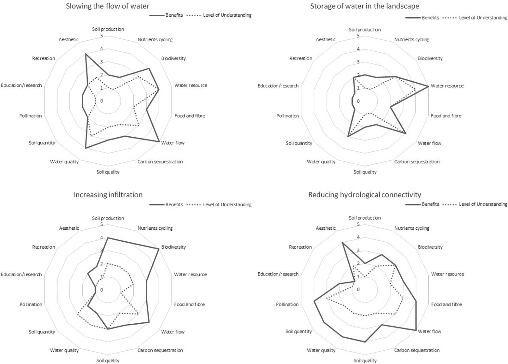
The potential benefits of each category of NFM plotted (as per Burgess-Gamble et al., 2017) against the present level of understanding of ecosystem services concluded from current studies. 1 = poor benefit/limited understanding; 5 = hugely beneficial/great understanding. All categories have a gap in potential benefits versus our current understanding.
V Scaling from plot to catchment
It is important to assess how, as NFM measures upscale, the dominant hydrological processes will change. At the plot scale, microtopography and soil properties such as bulk density, infiltration capacity and soil texture are dominant for runoff generation (Schmocker-Fackel et al., 2007). Some experimental models on the plot and hillslope to field extent (∼1–100 m2 up to 1 ha) have shown the benefits of NFM in reducing water flow and delivering environmental improvements such as soil and water quality. Field-based (1–10 ha scale) models have been successfully developed using plot scale experiments (see Ballard, 2011; Iacob et al., 2017; Wilkinson et al., 2014). For instance, a trial by Thomas et al. (2008) simulated water transpiration of 6 m of hedgerow using field observations, concluding that transpiration reaches 5.6 mm day–1, twice that of the same area of trees. Fluvial hydraulic based models can also be used on small extents for scenario modelling, such as the 1D/2D ESTRY-TUFLOW model (Fewtrell et al., 2011), which has shown simple models were valid at assessing channel dynamics in the Carlisle floods of 2005. It is vital such research continues across differing environments so hydrological processes are understood at a fine spatial scale – for example, through the use of in situ monitoring to understand an environment’s response to rainfall (e.g. infiltration or water storage potential), or experiments designed to mimic NFM intervention response to floods (e.g. rainfall simulators or infiltration meters) (Abudi et al., 2012). Plot-scale experiments are important to understand runoff mechanisms, but it is also important to recognise that as the study or implementation area increases in scale, dominant runoff generation processes will change, thus compromising the ability to upscale experimental understanding.
NFM quantification, therefore, requires studies of greater spatial extent to determine dominant processes, exploring the impact of schemes on the catchment in the way TFM is evaluated – for example, the investigation of management in the catchment headwaters and the subsequent impact upon flood risk in the lower catchment (where highest risk, urban areas are located). Research at this extent is vital to evaluate an NFM strategy’s ability to reduce flood risk in the long term, against the lowest return period, but highest magnitude events. However, the impact of NFM beyond the plot/hillslope scale upon the wider catchment is filled with uncertainty, often resolved as too limited to be conclusive (Dollinger et al., 2015; Lane et al., 2007). Critics claim NFM lacks proof of measurable impacts upon a catchment and within large floods, and is, therefore, unproven (SEPA, 2015). This was identified at experiments with woody dams in the Belford catchment in Northumberland, England, where the positive impact of leaky dams was difficult to quantify beyond the immediate area (Wilkinson et al., 2014). This is not a reflection of NFM ineffectiveness, but rather the complexity of large catchments where signals of NFM effectiveness are easily lost, the small amount of NFM trialled within the experiment may be insufficient or the timescale of impact being greater than the short-term monitoring (Rogger et al., 2017; Wheater and Evans, 2009). Catchment runoff generation is a combination of water storage and the lateral/vertical movement of water within the catchment as a function of interactions between land management and use as described earlier. Determining the dominant processes and flood risk parameters and how these are changed by NFM will require a combination of field-based studies and informed modelling at the appropriate scale.
Upscaling is understandably a challenge within NFM due to the intricacy of catchments not being reflected in a single small extent experiment of different dominant processes to those which manifest across a whole catchment (O’Connell et al., 2007). Previously, it had been suggested that models which fully address catchment complexities and plot-scale processes are required, such as physically based models with detailed process interactions (e.g. Bashford et al., 2002; Mendoza et al., 2015). However, these require specialised knowledge, can be overwhelmed by catchment complexities (and uncertainties) and typically comprise a sum of plot-scale validated processes rather than catchment-scale water movements, in turn limiting their validity at the catchment scale.
1 Integration of modelling and field observations
In order to overcome the problems highlighted above, the integration of field observations and modelling will require four key steps: (1) the monitoring of hydrological processes at a wide range of spatial scales – for example, gauging first-order tributaries to large river channels in a nested manner; (2) carefully selecting a control and impacted sub-catchment, with as many controlled processes as possible – for example, similar land management to minimise external impacts upon the monitoring; (3) as with the species reintroduction research alluded to in section III, it is vital that there is before and after monitoring of NFM implementation (e.g. BACI) to assess the impact NFM has had upon hydrology; and (4) this is all brought together in catchment-scale modelling, which is validated against the through network of monitoring. Only with this setup will we ‘believe’ upscaled models that predict NFM impact and avoid problems of spatial equifinality, whereby different combinations of NFM representation in models can lead to just the same hydrological changes at the catchment outlet, as has confounded other environmental models (Beven and Brazier, 2011).
Often, research focuses upon the investigation of one land use or land management to form an understanding of the processes. However, ideally, flood management schemes would combine multiple NFM measures in an area, each mitigating flooding caused by different hydrological pathways or dominant processes, to be effective. This is concluded in many studies of single forms of NFM, but in reality there is limited research to substantiate these conclusions (Burgess-Gamble et al., 2017). Few studies have reached the point of combining schemes when the basic hydrological processes in individual forms of NFM are still being understood. Nonetheless, a handful of important studies exist of multiple NFM schemes within a catchment. Adams et al. (2018) used field observations of swales, ditches and small ponds on the River Eden, northwest England, to assess the impact of further measures being added, concluding that peaks could be reduced by 5–10%. Wilkinson et al. (2010) created retention ponds and cascading channels in a pilot scheme that delayed flood peaks. Short et al. (2019) combined channel, riparian, field and woodland structures to reduce peak flows, but openly acknowledge more data are needed to confirm findings. Studies such as these now need to be built upon to even larger spatial extents, ideally at whole catchment scales, to assess the overall impact NFM may have. This might include delaying or reducing flood peaks, and the impacts of desynchronising flood peaks from tributaries can then also be explored. Arguably, reducing flood peaks should be the main goal to reduce flood risk, but all studies of NFM measures across a catchment would be valuable.
Finally, no studies have yet monitored a combination of NFM with TFM measures. The closest to this is research by Quinn et al. (2013), which combined storage ponds with earth bunds in Belford, UK. Though the objective was not the study of these interactions, it did show promising flood mitigation by catching bund overtopping. NFM will never fully replace TFM, but should be combined alongside it to enhance resilience of TFM measures. Yet, research of NFM and TFM to date remains siloed. A key opposition to NFM is the concern that schemes may be overwhelmed in the larger events that cause the most economic and environmental damage (Dadson et al., 2017). NFM may be confirmed to have a place in reducing smaller floods, which cause disproportionately large impacts on smaller areas, but if combined with TFM this may unite to form a more flood resilient catchment, especially under changing climatic and hydrological regimes. This is an area of vital importance that needs research, particularly as flood event magnitude and frequency increase (IPCC, 2013).
VI New approaches for evaluating NFM impact upon flood parameters
The above discussion and critique of examples of NFM current research is now summarised into a working framework to guide further research. For NFM to progress as a widely applicable form of flood risk management, NFM impact on flood risk parameters shown in Table 1 and throughout the above examples would ideally be addressed. In order to achieve this objective, a research framework is proposed:
This framework could be carried out over a variety of NFM schemes, some established (e.g. woodland restoration, flood plain restoration and leaky dams) and some barely explored (e.g. unimproved grassland, beaver reintroductions). Through further research, a firm baseline of knowledge for NFM can be established, which can be called upon to make future decisions about addressing flood risk in the UK.
Ongoing NFM implementation and monitoring, as suggested in this framework, will carry costs. In the UK, main river channels are the responsibility of the Environment Agency, making them eligible for funding streams such as the programme of flood and coastal erosion risk management (FCRM) scheme or ongoing monitoring through Light Detection and Ranging (LiDAR), routinely acquired by the Environment Agency Geomatics group for flood forecasting purposes (Brown et al., 2016). Headwaters have traditionally been under management by landowners and district councils, but with potential in the future for funding by the incoming Environmental Land Management Scheme (ELMS), which will pay landowners ca. £2bn per year to deliver ecosystem services from agricultural land, there is potential to fund both installation and maintenance as well as the potential monitoring of NFM.
VII Conclusion
This review has highlighted the key challenges and subsequent opportunities for further research to advance the understanding of flood risk in association with NFM. A research framework for future NFM to fill knowledge gaps was proposed, including working beyond an experiment to explore catchment scale impacts, unexplored environments and investigating trade-offs, wider benefits and costs. This framework provides a platform upon which to build an NFM evidence baseline through future research, which may make NFM a more viable flood risk management strategy. The framework is relevant to any scheme of NFM implementation.
Widening the NFM empirical evidence base should be seen as an opportunity for a new approach to flood research and the exploration of habitats and new flood resilience methods. Flooding is a significant global hazard predicted to increase in frequency and magnitude. NFM already forms pockets of community resilience to flooding, which will only expand with furthering NFM understanding.
Footnotes
Declaration of conflicting interests
The author(s) declared no potential conflicts of interest with respect to the research, authorship, and/or publication of this article.
Funding
The author(s) disclosed receipt of the following financial support for the research, authorship, and/or publication of this article: This work was supported by the University of Exeter; Devon Wildlife Trust; and the Environment Agency.