
Abstract
Since the inception of volunteered geographic information in 2007, this area of study has seen a proliferation of terms and concepts representing diverse forms of user-generated geographic data and systems. Despite the rich development of VGI (volunteered geographic information) in geography, recent trends indicate a disjointed research field. This progress report critically examines the trajectory of VGI, mapping its journey from an emergent set of practices to a fragmented research domain. Moving forward, it is up to the research community to either reignite the interaction and integration required to build a subdiscipline of GIScience or allow this research domain to extinguish.
Keywords
I Introduction
We have reached a critical juncture in the usefulness of the term volunteered geographic information (VGI). VGI was initially used to characterize geographic information generated by multi-point non-authoritative sources: location of incidents, observation of species, photos, and comments (Goodchild, 2007). Complications with the term were introduced early on, with terms such as ambient geographic information, involuntary (iVGI), and social sensing countering that not all contributions are knowingly or intentionally volunteered (Fischer, 2012; Regalia et al., 2016; Stefanidis et al., 2013).
With the growing body of literature, the division continued to grow. The range of concepts whirling within the VGI realm led to the emergence of terms that are more specific to the modes of user contributions, geographic contexts, and types of data: including digital skin (Rabari and Storper, 2015; Robertson and Feick, 2016), location-based social media data (McKitrick et al., 2022), facilitated-VGI (Kalvelage et al., 2018), location sensing (Ashton et al., 2017), social sensing (Janowicz et al., 2019), geo-social media (Ostermann et al., 2015), volunteered geographic videos (Lewis and Park, 2018), and multi-user digitizing actions (Vallejo Orti et al., 2024).
Many authors use terms like crowdsourcing, or a geographic variation thereof—crowdsourcing geographic knowledge (Sui et al., 2013), geo-crowdsourcing (Ballatore et al., 2013), or crowdsourced data and imagery (Gliozzo et al., 2016)—both independently and in tandem with VGI as a more explanatory descriptor. Resch (2013) distinguishes between collective sensing (aggregated anonymized data), people as sensors (subjective human observations), and citizen science (requiring additional human expertise), whereas See et al. (2016) use crowdsourced geographic information generically to connect crowdsourcing, citizen science, and VGI. A recent review paper on crowdsourcing geospatial data for earth and human observation refers to VGI as part of the growing trend of non-authoritative data sources (Huang et al., 2024).
There is such a proliferation of terms that it’s like all the synonyms for VGI have been loaded on slot machine reels; every pull yields a new combination. The multiplicity of neologic terms has led to the fragmentation of VGI, ultimately carving up and segmenting the concept.
Interestingly, Goodchild (1992) warned of the same risk of fragmenting in early GIScience days: “Without such arguments [the argument for taking a broader scientific view of GIS], the GIS field will fragment, and the GIS storm will blow itself out. […] Vendors will specialize in data input workstations, spatial analysis workstations or facility management systems, with little potential for interaction or integration” (Goodchild, 1992: 43).
From this warning, scholars took on the challenge of debating, and effectually establishing, the science of geographic information and the discipline of GIScience (Elwood, 2010; Longley et al., 2011). Key points along the road to GIScience include the distinction between GIS for science and as science (Goodchild, 1992). GIS for science can be viewed as a tool and toolbox for supporting scientific inquiry, insight, explanation, and understanding. Whereas GIS as science can be understood as “the extent to which GIS as a field contain a legitimate set of scientific questions, the extent to which these can be expressed and the extent to which they are generic, rather than specific to particular fields of applications or particular contexts” (Goodchild, 1992: 32), thereby avoiding the proliferation of diverging labels on top of overlapping concepts.
The GIS research community further advanced theories of GIS as a tool (hardware, software, and data), toolmaking (advancement of the tool’s capabilities), and science (fundamental issues raised by its use) (Pickles, 1997; Wright et al., 1997). An important point that Goodchild (1992), Wright et al. (1997), and others make is that GIScience has united diverse fields—remote sensing, cartography, geostatistics, and what is to become webGIS and GeoAI—within the spatial science discipline.
Fast forward 30 years, though, and this eerie prediction—that the GIS field will fragment—seems to be coming true for VGI. The concept of VGI has been driven by a research community keen to articulate, challenge, and expand its various subfields. However, these very subfields threaten the sustained value of VGI, especially if, and as, scholars abandon VGI in favor of more specific terms.
In operational contexts, the fragmentation of the concept is unlikely to matter. Whether social media feeds or OpenStreetMap data are considered VGI is trivial to emergency responders and humanitarian aid workers, for instance. For them, what matters is how any of these data and practices can be useful in understanding disaster impacts and saving lives. Similarly, as practitioners, we rarely use the term VGI when engaging communities in VGI projects because of its contextual irrelevancy; rather, the focus is on the purpose of the engagement: to better understand local food systems (Fast and Rinner, 2018), campus planning (Pierre et al., 2019), or building accessibility (Fast et al., 2023a).
Where the unification of the term does matter, like that of GIS (Goodchild, 1992), is in the interaction and integration required to build a scientific discipline. The fragmented nature and emergence of alternatives that better suit the specificity of individual topics erode opportunities for scientific interaction and integration that is required to sustain, critique, and propel VGI as a research domain within GIScience.
Yet, this fragmentation occurs alongside the rapid evolution of scientific, intellectual, and ethical questions surrounding the creation and use of VGI. It is being used as a tool to inform research and policy and a new way of accessing community and contextual knowledge: “[W]e are seeing VGI being used to answer new kinds of questions, representing real advances in geographic knowledge” (Goodchild et al., 2017). VGI is reaching communities that have been missing from authoritative data, and presents new ontologies, epistemologies, and methodologies with which to engage in research (Chen et al., 2019; Elwood and Leszczynski, 2013; Sieber and Haklay, 2015). VGI is powerful, and with that power also comes concerns of exploitation and misrepresentation, privacy, and data quality, among other concerns (Antoniou and Skopeliti, 2015; Medeiros and Holanda, 2019).
Going back to the seminal GIScience article, Goodchild (1992: 44) states “I believe we ensure the future of GIS by thinking about science rather than systems, and by identifying the key scientific questions of the field and realizing their intellectual breadth.” While I allow the question of VGI “science” to lurk below the surface, avoiding the boundary work that comes with defining science (for more on defining geography as a science, see Castree, 2005), this progress report aims to take a step toward understanding the rise, fragmentation, and future of VGI. The goal is not to introduce new terms or suggest a singular name, but rather to report on the progress in VGI by examining the scholarly literature that underpins the field.
The report begins with a review of VGI-related articles published between 2007 and 2023, setting the stage for a deeper exploration of the foundational research. Drawing on this literature, the paper uses word clouds to empirically illustrate the core concepts circulating within key themes common to all VGI studies: information, geographic, and volunteered. While all three core concepts exhibit signs of fragmentation, the discussion then delves deeper into the volunteered aspects of VGI, examining established models of participation to illuminate varying degrees of engagement and potential biases. As a productive way forward, the paper concludes by positioning VGI as a unifying language among many dialects.
II Tracing VGI publications through time
Inclusion and exclusion criteria applied to articles returned in literature search.
The trend depicted in Figure 1 shows a growth phase, a peak, and then a decline in the number of publications from 2007 to 2023. In the initial growth phase (2007–2013), there was a steady increase in the number of publications. This suggests a growing recognition of VGI in the academic community. Articles published from 2014 to 2018 show a pattern of fluctuating growth, reaching a peak of 242 articles in 2018. This peak represents the height of interest, where the concept saw both widespread application domains and scientific considerations such as methodological innovation, data quality investigations, and explorations of the impact the tool had on civic engagement, ethics, and privacy. Number of VGI-related publications from 2007 to 2023. 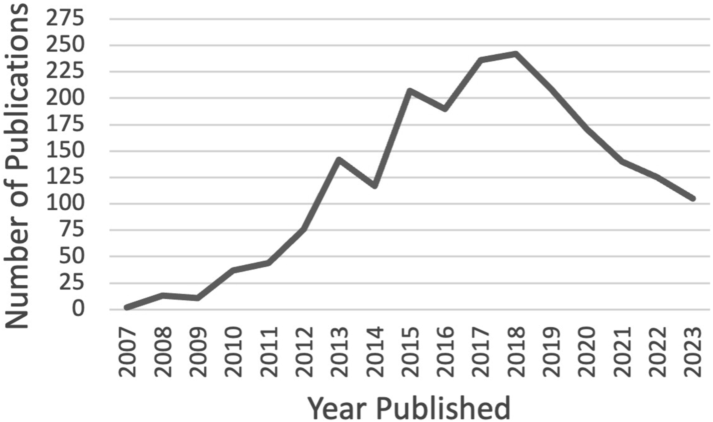
The subsequent years, however, mark a steady downward trend, revealing a more complex picture of the research landscape in which VGI now finds itself. Some of the decline post-2018 can be explained by the conceptual fragmentation, as discussed, as the review missed an unknown number of papers that engage with geographic information that is volunteered but do not use the term VGI or crowdsourcing; this is especially true for projects from outside of geography. This body of literature also misses similarly unknown research publications that employ VGI systems and their methodologies without being explicitly labeled as such in the title, abstract, or keywords; in a similar way we do not need to specify “GIS” on the front page of publications that use GIS.
Despite the limitations, this body of literature sets the scene for a deeper exploration of the key concepts that substantiate VGI literature. For scholars who would like to make their own exploratory and evaluative inquiries with the body of literature created here, a Zotero database that includes all the VGI citations is openly available (Fast and Falahatkar, 2024).
III The many synonyms of VGI
As the domain of VGI matures, the language used to describe its core themes become increasingly important. Terminology is not just a matter of semantic preference but a foundation for shared understanding (Bracken and Oughton, 2006). Conversely, a lack of shared terminology can indicate an increasingly fragmented and splintered intellectual community.
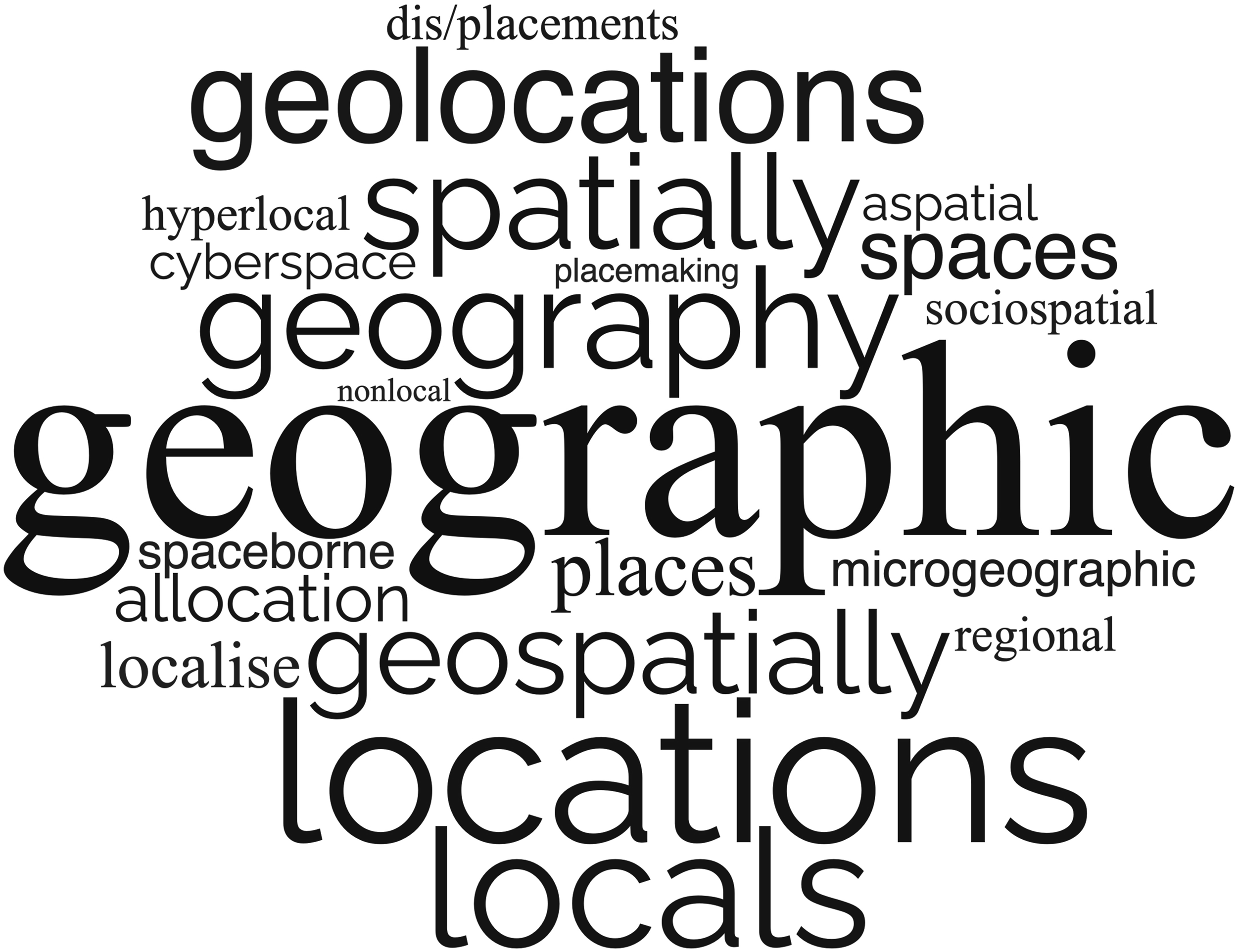
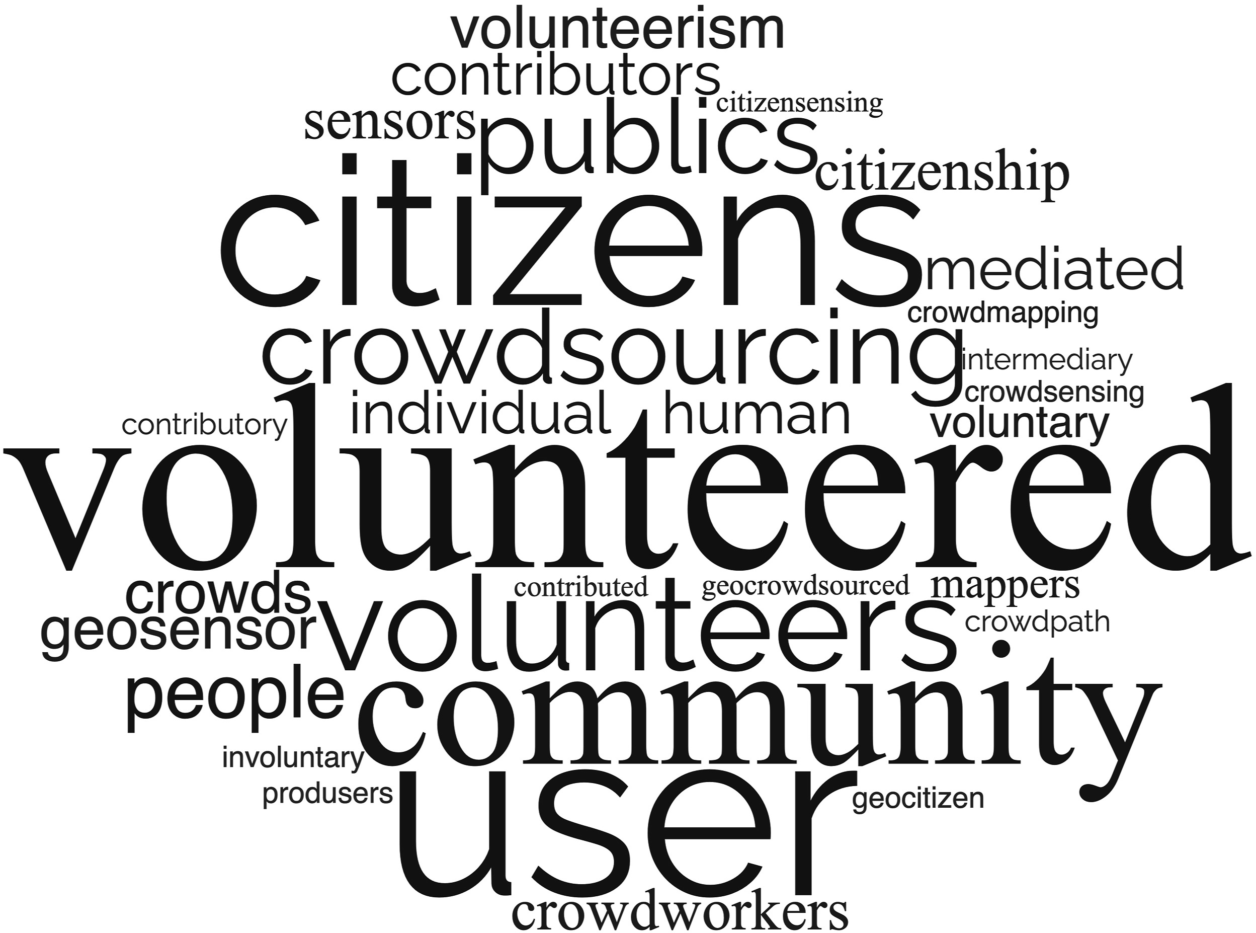
Building on the tradition of revealing the intellectual core of disciplines through literature and language (Sidorova et al., 2008), word clouds can effectively demonstrate the diverse and evolving vocabulary that encompasses the central themes prevalent in the literature. NVivo’s word frequency function, manual language model-assisted synonym extraction, and word clouds (via https://www.wordclouds.com) were used to collect, analyze, and visualize the variations related to the three core themes: information (Figure 2), geographic (Figure 3), and volunteered (Figure 4). A word cloud showing word frequency for “information” and related synonyms from the titles and abstracts of VGI research literature. A word cloud showing word frequency for “geographic” and related synonyms from the titles and abstracts of VGI research literature. A word cloud showing word frequency for “volunteered” and related synonyms from the titles and abstracts of VGI research literature.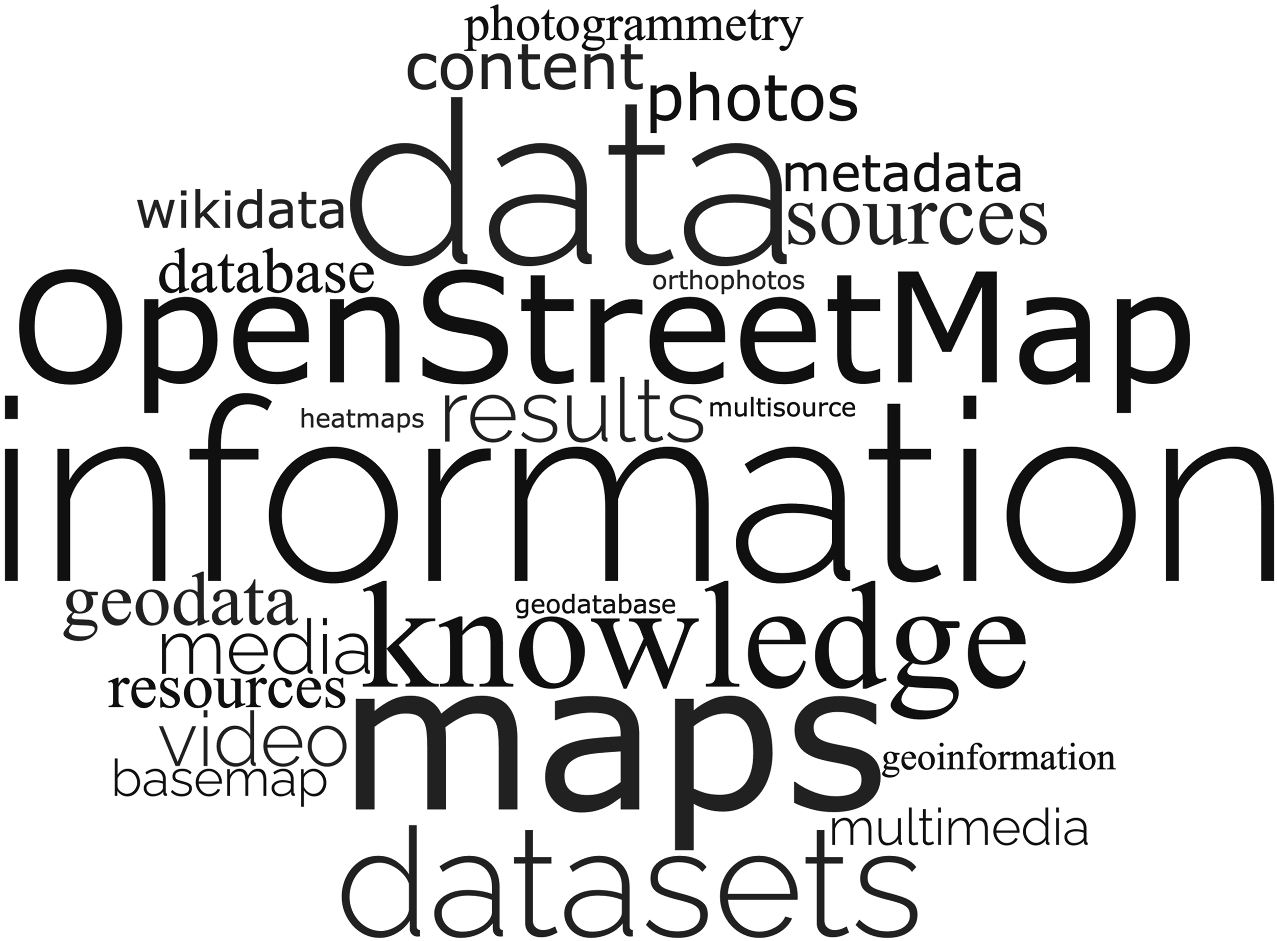
By scrutinizing the synonyms that have emerged around these key themes, I strive to demonstrate the field’s potential fragmentation, but also how these core concepts can provide a common orientation for diverse research practices and approaches, within an increasingly crowded conceptual landscape. Consider, for instance, how projects on “location-based social media data” and “multi-user digitising actions” have overlapping concepts and methods. Yet, the fragmentation forces researchers to navigate and integrate across disparate literature—to put the fragments together—when learning and developing VGI projects. Taken together, these illustrations are intended to challenge us to reflect on which terms we gravitate towards and how these choices influence our understanding of contributions, and contributors, in the field.
1 Information
Most prominently, by frequency, is the term “information.” The body of literature highlights that VGI, at its core, represents different types of data, information, content, and contributions. Other variations dig deeper into the specifics of content types, such as volunteered geographic videos, photos, digital traces, maps, and sources (Rinner and Fast, 2015). The literature also extends into the realms of media and results.
Closely related to research in GIS and spatial data infrastructure (SDI), VGI encompasses elements of data collection, processing, and validation methods that transform raw data into actionable information. It also involves the rigorous scientific principles that ensure the reliability, accuracy, and usability of VGI, including the semantic processing required to derive meaningful interpretations from vast, or small, datasets. I view this as the backbone of the domain.
2 Geographic
Next is the term “geographic,” which inherently links the information to a location, broadly defined, as evidenced by its frequent co-occurrence with spatially oriented terms such as geospatial, local, location, place, regional, space, and spatial. This extensive list reflects the diverse and nuanced ways in which geographic concepts and spatial relationships are represented and discussed in VGI, covering a broad spectrum from spatially explicit locations, local contexts, and broader spatial theories.
If information is the backbone, then the geographic element is what makes VGI special. The location is where the data acquires significance. Despite the conceptual overlap with citizen science, it is the spatial specificity and commitment to geographic contextualization that define VGI’s unique contribution to the field (Fast and Haworth, 2020).
The geographic component is also more closely associated with the application domain, emphasizing the practical use of VGI in real-world contexts. It is the geographic—where things happen—that facilitates nuanced understandings of place-based phenomena, catering to diverse geographic research inquiries ranging from urban planning, environmental monitoring, disaster response and humanitarian efforts (Granell and Ostermann, 2015; Haworth, 2018; O’Brien et al., 2016).
3 Volunteered
Volunteered—with the broadest array of synonyms—encompasses a range of actors including citizens, contributors, communities, corporations, crowd, humans, individuals, participants, people, publics, sensors, users, and volunteers. The breadth of participation represented by these terms has led to a persistent divide between active and passive VGI systems (Fast and Rinner, 2014). Active VGI requires the knowing and intentional participation of volunteers, akin to participatory GIS (Dunn, 2007; Kar et al., 2016; Sieber, 2006), whereas the passive form emerges from mining digital interactions that were not expressly generated for a research study, such as geolocated social media data. However, participation in VGI is not as binary as the active and passive framing suggests.
Questioning the role of the volunteer parallels a recent debate about citizen science, which has undergone its own conundrum of rebranding (Cooper et al., 2021). The conundrum lies in the global north definition of the “citizen,” a legally recognized, tax paying, and voting subject. Some are calling for more intentionally inclusive terms, such as community science, which have their own history and problems. Cooper et al. (2021) conclude that replacing the term can do more harm than good and instead suggest focusing on advancing opportunities for more inclusive citizen science. Similarly, in the realm of VGI, deepening our understanding of volunteers, or civic data sources (Sangiambut and Sieber, 2016), becomes essential to cultivate more inclusive and diverse forms of engagement.
IV The spectrum of participation in VGI
Understanding participation in VGI requires models that can provide a structured way to assess the nuances of participation and highlight the complex landscape where these interactions occur. Turning to established models of participation, Haklay’s (2013) ladder of participation in citizen science, ranging from crowdsourcing to extreme citizen science, articulates varying degrees of representation, yet cautions against a hierarchical valuation: the higher up the ladder does not mean “better” participation, but rather, different participation for different purposes.
Moving beyond a linear scale, participation can be envisioned as a multidimensional space where diverse models coexist. The wheel of empowerment by Rock et al. (2016), and the parity of participation framework by Blue et al. (2019)—combining Arnstein’s (1969) ladder of participation and Fraser’s (2009) tripartite of justice—emphasize the multifaceted nature of participation.
Here the task lies not in counting or classifying contributions but in appreciating the depth and breadth of participation, as well as paying acute attention to misrepresentation and potential exploitation. True parity of participation, explains Blue et al. (2019), involves not only representation (those who already have a seat at the table, or rung on the ladder) but also the recognition of historically excluded actors and the redistribution of resources and power.
Historically, the predominance of cisgender white male professionals in the discipline of geography and GIScience has led to a knowledge landscape that disproportionately reflects that worldview, often resulting in the underrepresentation and misrecognition of minority groups. VGI presents an opportunity to diversify this landscape and acknowledge geographies that have been marginalized or overlooked.
From early on, we saw a “changing publics that undertakes and underpins” VGI projects (Lin, 2013). The diverse backgrounds, varying motivations, and different contribution behaviors highlight VGI as a socio-technical system that differs significantly from the traditional authoritative systems for producing geospatial information (Elwood, 2008; Elwood et al., 2012; Johnson et al., 2015; Leszczynski and Elwood, 2015; Sieber and Haklay, 2015).
VGI projects fill gaps in authoritative data, often addressing areas where traditional datasets are lacking. These projects not only generate new data representing missing perspectives (Fast et al., 2023b) but also include perspectives that might otherwise be “ontologically impossible” (Elwood, 2022). For instance, speaking to indigenous knowledge of place, Briggs et al. (2020) show that VGI and public participation GIS can “reshape and adapt geospatial technologies to be more in harmony with an explicit social and cultural context.” Similarly, projects like QueeringTheMap capture the voices and memories of situated everyday encounters in “digitally mediated community spaces” and build “visibility, representation, recognition and solidarity for/in communities” (Kirby et al., 2021:1046; also, an instance of literature that contributes to scholarship on map-based crowdsourcing without using the term VGI anywhere in the paper).
Disability mapping is another example, where active mapping communities across the globe—AccessNow (Fast et al., 2023a), OpenSidewalk (Mobasheri et al., 2018), Project Sidewalk (Saha et al., 2019), and WalkRollMap (Laberee et al., 2023) to name a few—are responding to missing official data by crowdsourcing barriers and accessibility features in the built environment for people with disabilities. These mapping initiatives, driven largely by disabled communities, are not only filling in data gaps, but enhance data quality, engage with the communities they aim to serve, and achieve broader social and policy impacts. In short, this domain holds the promise of supporting and knowing other geographies (Oswin, 2020).
Of course, demographic differences and geographic unevenness in the production of VGI remain. The proliferation of VGI-enabled technologies, paired with the recognition that VGI is a social process (Elwood et al., 2012) has unequally impacted spatially and socially diverse groups. Geosocial media, a common conduit for passive VGI, has more users characterized as young and affluent (Robertson and Feick, 2016; Schweitzer, 2014). On the other side of the demographic spectrum, Bruce (2016) and Bishop et al. (2023) found that older adults have reduced access to web-based knowledge exchange and lower representation in the resulting data. The composition of OSM contributors and contribution patterns (e.g., social networks among OSM contributors) vary significantly based on time, location, and gender (Bégin et al., 2018; Gardner et al., 2019; Stephens, 2013). Young et al. (2021) emphasize that the global data landscape remains heavily skewed towards English-speaking, urban, and affluent areas in the Global North, and they highlight VGI provides opportunities and challenges for organizations in the Global South to produce their own data to counteract these inequalities.
The nature of VGI, relying on contributions from broad, diverse, and sometimes unknown (and unknowing) communities, can lead to variability in accuracy and completeness (Chehreghan and Ali Abbaspour, 2018; Mozas-Calvache and Ariza-López, 2019). As ethical implications continuously arise from the misuse of data, such as carto-vandalism (Juhász et al., 2020), many academics are calling for stricter data protection measures and ethical guidelines for locational information (Goodchild et al., 2022). Paralleling research on digital geographies (Ash et al., 2018), future studies should prioritize understanding how contributions vary across socioeconomic profiles and geographies, addressing digital divides and data colonialism, enhancing data quality and accuracy, and exploring ethical and privacy implications.
V Conclusion: Towards a unified language of VGI
Reflecting on 17 years of progress in VGI, the proliferation of synonyms—each with its own shade of meaning—highlights the intellectual vibrancy within VGI research but also challenges the field’s coherence. Through the lens of longstanding concerns in GIScience about the fragmentation of tools and techniques across specialities, this examination of linguistic variations illustrates the ongoing conceptual fragmentation occurring in VGI literature.
As researchers continue to adopt hyperspecialized nomenclature to describe similar processes and outcomes, conceptual ambiguity grows. Establishing a strong and unified foundation of scholarly inquiry is essential to challenge and expand the currently exclusionary boundaries of what we know and whose knowledge is recognized, represented, and redistributed. Here we need a productive way forward that embraces diversity rather than fuel divisiveness within the domain of VGI.
To conclude, I propose that we view VGI and its variations using a language and dialect analogy 1 . VGI can be seen as a unified language with local dialects—active, passive, digital skins, geotagged media, crowdsourced geographic information—applicable to various use cases, research agendas, and community scenarios. If we accept this framing of VGI, then VGI sustains its value as a language that unifies the many dialects.
The framing presents us with a choice, not unlike deciding the fate of a language teetering on the brink of obsolescence. Do we let the unique dialects of VGI drift apart, losing the coherence of our collective understanding? Or do we hold on to VGI as a lingua franca, a unifying language, to create the scholarly space to explore the potential and limitations of its application and scientific study? The decision rests with the collective: to revitalize and harness the scientific potential of VGI or to watch as it becomes a footnote in the progress of geographic inquiry.
Footnotes
Declaration of conflicting interests
The author(s) declared no potential conflicts of interest with respect to the research, authorship, and/or publication of this article.
Funding
The author(s) received no financial support for the research, authorship, and/or publication of this article.