
Abstract
The sub-discipline of electoral geography contains research threads that draw on different theoretical, philosophical, and methodological traditions. I link these threads to the ‘digital turn’ that is occurring in the electoral landscape and in the discipline of geography itself. The use of digital technology is increasingly shaping electioneering and data regimes, providing new conceptual challenges concerning the spatial mediation and subsequent knowledge politics of voting and campaigning. Responding to these challenges requires not only building on the subfield’s tradition of interdisciplinarity but also on strengthening intra-disciplinary dialogue, in particular working across the quantitative–qualitative divide.
I Introduction
Geographical research has undergone a ‘digital turn’ as digital technology and practice have come to fundamentally influence what is studied, and how (Ash et al., 2018, 2019; Elwood and Leszczynski, 2013; Wilson, 2018; Zook et al., 2004). Notable areas of geographical engagement with this turn include urban studies and smart cities, governance, critical GIS, and geospatial big data. However, surprisingly absent from recent overviews of these developments are discussions of voting and electioneering, and the sub-discipline of electoral geography more generally (see Ash et al., 2019; Kitchin et al., 2017). Yet it’s clear that digital developments are having far-reaching impacts on issues of electoral practice, activism, campaigning, and data (Council of Europe, 2017; Margetts and Dommett, 2020; Magin et al., 2017; Miller 2016). The technology available to campaigners and citizens is evolving from one election to the next. The hybridisation of the media makes it difficult to track and understand where people get information from and how they now communicate about political issues (Bennett and Segerbeg, 2012; Howard, 2005). Concerns of micro-targeting, fake news, and interference are now commonplace, with issues of transparency and regulation high on the agenda (Harker, 2020; Power, 2020). Data sources have changed dramatically – big data and social media data require new techniques and data conceptualisation (Arribas-Bel, 2019; Dommett, 2019).
This digital turn does not mean that we must all now study digital technology – although it is hard not to overstate its importance as a topic of inquiry – but rather that we think critically about ‘the inflection of geographical scholarship by digital phenomena’ (Ash et al., 2019:5). This also does not mean creating a new silo of ‘digital geography’, which would be decontextualised and apart from the rest of the discipline. Rather, we should re-contextualise our sub-disciplines by exploring how digital technology functions ‘as a site and mode for intersectional research’ (Ash et al., 2019:5). Whilst this process is underway in fields such as urban geographies, it has been neglected when it comes to electoral geography and so this paper instigates this by drawing attention to issues of data, methodology, and conceptualisation in the context of contemporary elections.
Previous critical interventions concerning the sub-discipline (Agnew 1990; Forest, 2018; Johnston et al., 1990; Leib and Quinton, 2011; McGing, 2015; Page, 2019; Page and Dittmer, 2015; Scott and Wills, 2017; Secor 2004), whilst highly useful, have tended to generally conclude with the need to widen the location of case studies and promote the use of the authors’ favoured theoretical approach. These aren’t problematic suggestions per se, and indeed, the former point features in the argument of this paper. However, such suggestions can feel like building extensions onto a house but without adding internal doors. If we’re not careful, we can be left with extensions upon extensions: annexes built with limited access to the main house. Therefore, I hope not to neglect the internal doors and corridors needed to develop intra-disciplinary dialogue. I primarily go about this by pinpointing a need to bridge the qualitative–quantitative divide. I argue that reckoning with the ‘digital turn’ offers a way to frame and begin this move. In order to effectively unpack the digital and spatial dynamics of modern elections, we must better interweave the existing analytical threads within the study of electoral geography, and we must also continue the sub-field’s history of interdisciplinary analysis by engaging with a new set of research areas, in particular computer science and social movement studies.
To justify this argument and the work it entails requires understanding the nature of electoral geography as a sub-field and so I begin by outlining the different approaches and threads of analysis that have developed, putting them in their historical context. This helps to better understand the nature of existing critiques – especially those that point to a narrow methodological repertoire and under-theorisation – whilst also highlighting existing strengths such as an inherent multi-disciplinarity and acute sensitivity to issues of spatiality. I then explore the ‘digital turn’ in the discipline of geography (Ash et al., 2019), discussing what this turn means for approaches to geographical research more broadly, before detailing ideas of spatial mediation and knowledge politics in particular. Two short case studies follow, exploring electioneering and digital developments in recent UK and US elections. I then discuss how such developments are challenging key ideas in electoral geography. I demonstrate how it will be difficult to get a handle on such challenges unless analytical approaches evolve to tackle data, method, and conceptualisation issues that are being driven by the digitising electoral landscape.
II The Study of Electoral Geography
The topics and phenomena considered under the label of electoral geography can be organised in multiple ways. Table 1 collates different attempts to summarise what constitutes the subject. Drawing across these examples we can see the following areas of interest: 1. How voters and political parties interact with place, understood as a multi-scalar ‘milieu’ 2. How this interaction manifests in spatialised patterns of voting behaviour 3. How electoral systems and the drawing of electoral districts translate votes into representation 4. How political power can influence processes in 1)-3) (i.e. explicitly through gerrymandering or ‘pork barrel’ politics and more generally through the impact of social and economic policy) Areas of focus for electoral geographers.
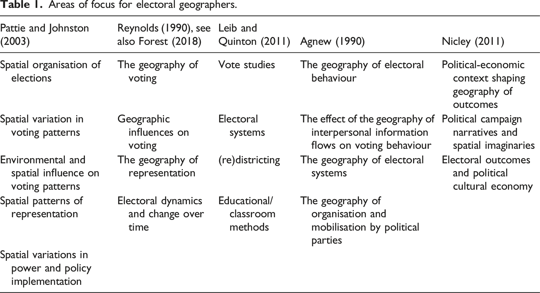
Below, I outline points of interest most relevant to the later case studies. This means I do not focus on redistricting, gerrymandering, or ‘pork barrel’ politics, as important as they are and despite the numerous studies on such issues.
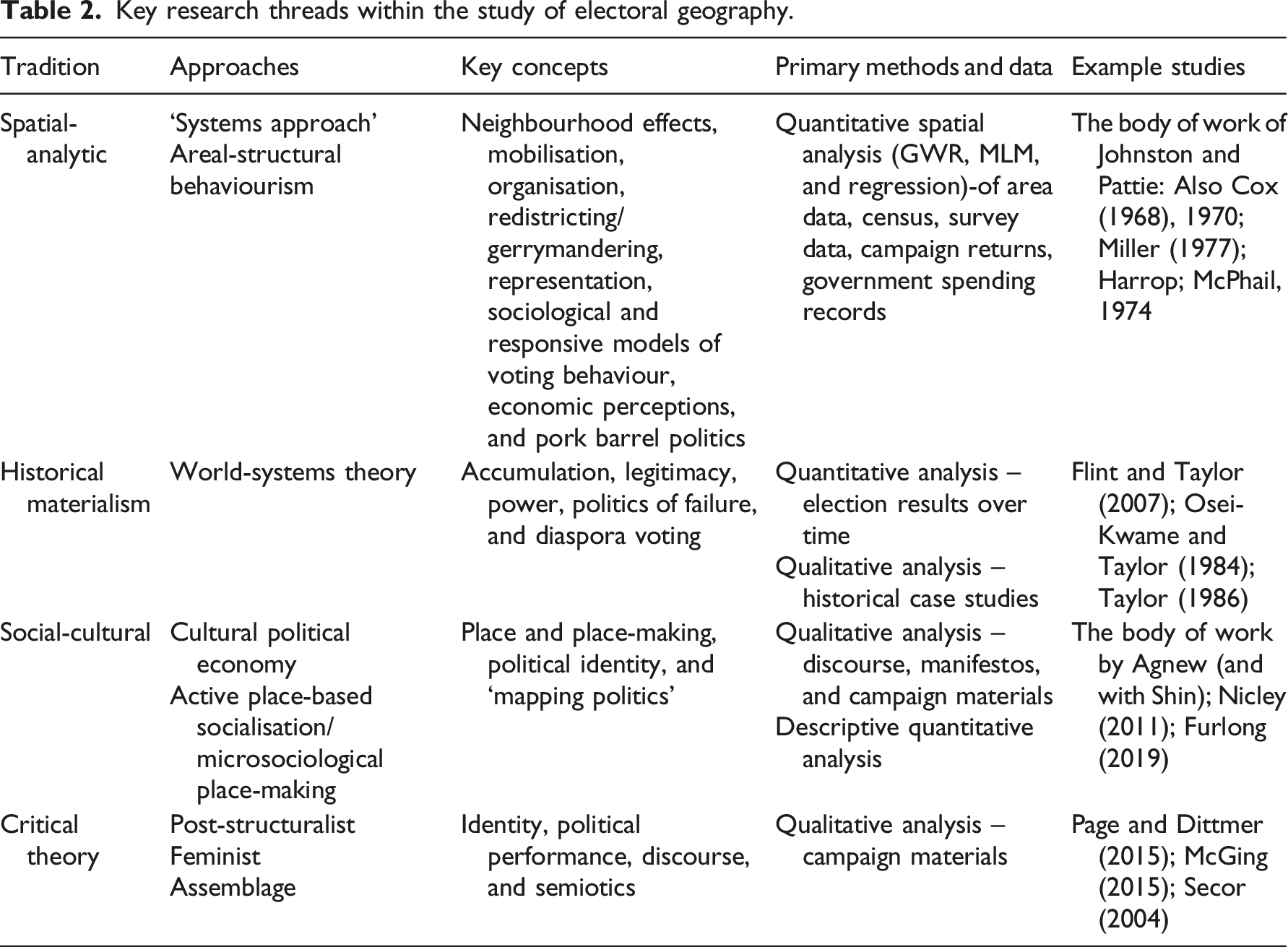
Key research threads within the study of electoral geography.
1 The Research Threads
Electoral geography research initially focused on the spatialised patterns of votes, linking these to the presence of agriculture, mining, and the like (see overview in Forest, 2018: 2–3). Such analyses were somewhat limited to speculating on correlations presented in maps; critiques of such geographical analysis have charged it with undertaking a rather descriptive and ‘bland empiricism’ (Johnston et al., 2019a: 1135). However, as data availability and computing power increased, statistical analyses were better able to consider the dynamics between areas and voting outcomes. In the wake of the ‘quantitative revolution’ (Barnes, 2004), there followed an explosion of studies taking such an approach; elections were described as a ‘geographer’s delight, providing researchers with large amounts of data that can be mapped and spatially analysed’ (Johnston and Pattie, 2009: 1865). This ‘positivist’s dream’ (Taylor, 1978: 153) informs the ‘spatial analytic’ approach.
Work in this area initially explored area-level data (Prescott, 1959). However, as individual survey data became more readily available, the two were integrated in attempts to mitigate the ecological fallacy (presuming aggregated trends and patterns map onto individual ones). Matching trends in social sciences at the time, this ‘quantitative-theoretical orientation’ in electoral geography was often behaviourist in nature (Rowley, 1969: 398) but also interdisciplinary, linking primarily to research in political science but also law, history, social psychology, sociology, economics, and opinion surveying (Kovalcsik and Nzimande, 2019: 208).
Important to this earlier work was empirically demonstrating the importance of a spatial approach for electoral analysis (McPhail, 1974), captured in the composition versus context debate. Those in the former camp argued that we best understand spatialised voting patterns by looking at the composition of individual characteristics in an area, with any remaining variance likely to be so small it can be safely classed as epiphenomenal (King, 1996). What matters most are the sociodemographic cleavages in a society around which parties form. These can then be linked to responsive models of voting behaviour as voters respond to party cues and assess the performance of government, usually in relation to their handling of the economy.
In contrast, geographical analysis acknowledges the importance of these phenomena but sees issues of space, place, and scale – context – as in fact being constitutive of them (Agnew 1996). This point is central to Johnston and Pattie’s (2006) authoritative overview, Putting Voters in Their Place. One key spatial idea is ‘the neighbourhood effect’. Multiple analyses demonstrate spatial voting patterns stronger or weaker than what would be predicted by composition alone (Johnston and Pattie, 2006: 46–54; Miller, 1977). The strength of these dynamics is different for different demographics in different places and can be influenced by processes such as migration (Cox, 1968, 1970). Such patterns have been shown across studies; more difficult is explaining them. Consumption-oriented explanations highlight the importance of local labour and housing market dynamics (Dunleavy, 1979). Communicative explanations argue for the importance of conversation and information networks (see Johnston and Pattie, 2006; Pattie and Johnston, 2000: 106–143). Furthermore, geographical analyses draw attention to the importance of scale when it comes to voter perceptions and responsive approaches; assessments of government performance are not done in a vacuum but in place and at varying scales in relation to perceived conditions of the household, the neighbourhood, the city, the nation, etc. Voters must also consider what level of government is responsible, a process that varies between electoral systems (Johnston and Pattie, 2006: 144–185; Lewis-Beck, 1986).
A further research area central to this approach concerns campaigning. Analyses have demonstrated how, especially in first-past-the-post (FPTP) systems, targeted campaign expenditure and emphasis on local campaigning and canvassing can be influential. Parties can improve their electoral outcomes by rationally prioritising their campaign resources in marginal seats. These arguments have been made by electoral geographers and political scientists, usually using a mix of survey and campaign expenditure data (Denver and Hands, 2004; Pattie and Johnston, 2003; Whitely and Seyd, 2003).
So far, this discussion has focused on the topics of interest that have been pursued primarily (although not solely) from the spatial-analytical perspective, exemplified in particular by the work of Ron Johnston and Charles Pattie. This constitutes the largest thread of electoral geography and has generally focused on Anglosphere examples and quantitative methodology (Johnston, 1981; Johnston and Pattie, 1998, 2004, 2009, 2011, Pattie and Johnston, 1997, 1999, 2000, 2009). It has tended to take what has been called a ‘systems approach’; a framework of input (geographical influences on voting), throughput (the translation of votes into seats), and output (spatial effects, such as spending). Such analyses have tested and explored the concepts discussed above, whilst being sensitive to the feedback loops across these system elements (Taylor, 1978; Johnston, 1979). I now turn to the other contributions to electoral geography research.
Taylor’s work draws upon world-systems theory and takes a historical materialist approach; elections are assessed within a wider framework of capital relations, with parties understood as seeking to balance accumulation and legitimacy in a dialectical fashion. Taylor has criticised the dominant approach in electoral geography for a tendency to accept the liberal democratic model as the status quo for elections, meaning that ‘[A]ll of a sudden, conflicts have disappeared, history is forgotten and political parties are nothing more than vehicles for transmitting candidate and voter preferences’ (Flint and Taylor, 2007: 202). For Taylor, the historical socio-economic developments of liberal-social democracies support a ‘congruent politics’ in which there is a societal cleavage mirrored by a clustering of policy interests. In contrast, peripheral states tend to be characterised by an unstable ‘politics of failure’ in which disconnected, or even entirely contradictory, dynamics have developed between the demos and the elite (see Flint and Taylor, 2007: 203–234; Taylor, 1986; Osei-Kwame and Taylor, 1984). Taylor’s work then, is an explicitly theoretical attempt to engage with electoral geography, more macro in scale and historical than much of the systems-approach. As Leib and Quinton (2011:18) note however, compared to the spatial analytic, the world-systems approach has generally received less attention in electoral geography overall.
The last threads of electoral geography I class as social-cultural and post-structural in character, and both can be broadly linked to the ‘cultural turn’. Barnett (1998: 380) summarises the turn as committed: ‘...to epistemologies…that emphasise the contingency of knowledge claims and recognise the close relationship among language, power, and knowledge. Both epistemologically and in the construction of new empirical research objects, the cultural turn is probably best characterised by a heightened reflexivity toward the role of language, meaning, and representations in the constitution of “reality” and knowledge of reality’.
Here, the most long-standing work is probably that of Agnew whose case studies of Italy (Agnew 1997, 2002, 2007; Agnew and Shin 2008) draw attention to what he calls ‘micro-sociological place-making’, a perspective that examines political identity and party organisation alongside everyday life. Notable in Agnew’s work is a combination of qualitative and descriptive quantitative approaches to map the politics of place and understand the effect of the geography of interpersonal information flows on voting behaviour (see also the study by Furlong 2019 which works in a similar vein). Other studies in this strand emphasise qualitative analysis, and recent work has engaged with feminist perspectives (McGing, 2015; Staehli et al., 2004; Secor, 2004) and assemblage theory (Page, 2019; Page and Dittmer, 2015) to explore how campaigning strategies and materials draw on place, identity, and spatial imaginaries. The nature of this turn has therefore produced an interesting, but disparate, set of studies.
2 Picking At The Threads
The threads discussed above draw upon very different methodological traditions. The spatial-analytic approach is closer to political science than anything else under the umbrella of contemporary political geography (Ethington and Daniel, 2007, although Kovalcsik and Nzimande, 2019 make a case for some overlap with quantitative urban geography). In contrast, the social-cultural and post-structural strands are part of the cultural turn. Aside from the mixed-methodologies of Agnew, we can see the divide manifests through quantitative and qualitative approaches. This mirrors the context in geographical analysis more generally, where Johnston et al. (2019b: 965) have described the situation as one where the approaches are essentially separate, coexisting with limited interaction and operating in relative ignorance of each other’s activities. Whilst there is methodological diversity and innovation within these approaches, there is next to no dialogue between them.
I return to this divide later. However, for now, we turn to the critiques historically levelled at electoral geography. As the largest thread is the spatial-analytic (by some margin), most criticism has tended to come from other approaches (see Agnew, 1990; Cupples, 2009; Forest, 2018; Leib and Quinton, 2011; Reynolds 1990; Secor, 2004; Taylor, 1978; but see also acknowledgement and discussion in Johnston and Pattie, 2004). As well as the broad materialist critique already discussed from the perspective of Taylor, critiques of the spatial-analytical approach have included the following: • A narrowly quantitative approach – an ‘unrepentant positivist or naive empirical outlook’ as Warf and Leib (2011:3) put it. • Over-emphasis on institutionalised politics – that is, political parties and electoral systems – to the detriment of other political actors in the electoral process. • A propensity to shy away from developing social theory.
We should consider the defence against these charges. Critiques of quantitative approaches have had a tendency to sketch a rather caricatured picture of blinkered positivists stuck in the 1950s, seeking universal laws via number-crunching (see discussion in Johnston et al., 2019a, 2019b). In reality, the philosophical worldview of quantitative approaches is often far more subtle than it is given credit for, and ongoing innovation has seen multilevel modelling, propensity-matching, and spatially weighted regression utilised to try and account for the complexities of scales and networks. Next, elections are institutionalised events, and the institutionalised actors – political parties and MPs – remain the key players, and the spatial characteristics of electoral systems are hugely important. Whilst other actors should be given more space in relation to digital developments (see below), it still makes sense to keep political parties at the centre of any electoral ‘ecosystem’ (Dommett et al., 2020).
Finally, whilst electoral geographers in the spatial-analytic thread have not necessarily devised masses of social theory surrounding voting behaviour, they have certainly quantitatively tested political and sociological theories, frequently exploring key theoretical approaches including theories of ideology, socialisation, and valence, whilst integrating key geographical issues stemming from the neighbourhood effect. The voting models built by electoral geographers are therefore suffused with theory, and indeed, after decades of electoral geographies evidencing the importance of context, elections are now being explored by political scientists in ways sensitive to issues of scale, space, and place (see Ethington and Daniel, 2007; Fisher et al., 2018).
To counter to some of the existing critiques of electoral geography is not to say there is no need for research to evolve. The rapid development and integration of digital technology into elections provides a fundamental challenge to the way that the sub-field of electoral geography has historically operated. Whilst there will remain research opportunities for these different approaches, to more comprehensively capture the complexity presented by digital technology requires dialogue between these threads and methodological approaches. To demonstrate why this is the case, the following section outlines the way in which the ‘digital turn’ has been conceptualised by geographers, before providing context via two case studies related to digital developments in electioneering.
III What is the ‘Digital Turn’?
When it comes to the term ‘digital geographies’, Wilson (2018) identifies a ‘productive slippage’ in its conceptualisation which he traces to Zook et al. (2004). As Wilson (2018:10) puts it, in the late-1980s and early-1990s research was using digital technology to explore a geographic phenomena. However, the move in thinking highlighted by Zook and others was to recognise ‘that digital technology, itself, shapes and impacts geographic phenomena’ (Wilson 2018: 9). This second view has only grown in relevance as digital technology increasingly permeates our lives. The approach to digital technology, then, went from thinking about its use as an analytical and communicative tool (in particular GIS) to analysing its embedded role in the fabric of our daily lives, and the new geographies and spatialities it was itself generating.
Considering the role of digital technology in a holistic fashion therefore requires a broad conception of digital that considers not just GIS or social media but also databases, software, hardware, email, and apps, alongside wider issues concerning practice, engagement, and discourse associated with such technologies. With this understanding scholars tend to refer to ‘the digital’, rather than just ‘digital technology’. It is this move to a wider conceptualisation of the digital that has recently been linked to a ‘turn’ in geographical scholarship.
Ash et al. (2018) draw out three overlapping elements of this turn. Firstly, geographies produced through the digital relate to geographical knowledge production. This is an epistemological concern, examining changes in ‘knowability’ brought about by increasing availability and use of geographical data. In other words, digital technology, especially GIS, remote sensing, and spatial statistics, enables new geographical knowledge by allowing geolocated data to be collected, analysed, and presented in ways not previously possible. This change has concerned speed (of collection and analysis), scale, efficiency, precision, and degree of shareability, allowing for political engagement in ways not previously possible, and generating knowledge in ways system providers often did not foresee. I return to these new ‘knowledge politics’ below.
Secondly, geographies produced by digital relate to how digital mediates, augments, and creates place. Earlier accounts suggested the rise of ICT rendered key aspects of geography irrelevant (e.g. Cairncross’s (1997) notion of ‘the death of distance’), whereas later accounts have instead pointed towards the potential for the digital to ‘splinter’ or ‘fragment’ places (Graham 1998; Graham and Marvin, 2001). Work in this area has often focused on the ‘smart city’ (Shelton et al., 2015; Kitchin, 2014). Ash et al. (2018: 32) argue that digital technologies and georeferenced data are ‘having profound effects on the production of space/spatiality, mobility, and knowledge politics’ since they ‘mediate social encounters within spaces and provide different ways to know and navigate locales...augmenting a whole series of activities such as shopping, wayfinding, sightseeing, and protesting’. In this paper, I add electioneering to the list.
Finally, geographies of the digital refer to the examination of the material infrastructure of digital technology – smartphones, tablets, and data centres (Blum, 2012; Malecki, 2002; Zook, 2005) – and the digital architecture of, say, a social media platform, and how it intermeshes with embodied practice (Barns 2019). This means being sensitive to the digital affordances offered by different digital platforms and making sure not to lump them together: for instance, the highly individualised and micro-blogging nature of Twitter offers something very different to the pages and private groups on Facebook.
This threefold heuristic summarises the different angles that geographical scholarship can take concerning the digital. However, further conceptual specificity is helpful to discuss more specific implications for geographical thinking around elections, and here I focus on spatial mediation and knowledge politics, with a particular focus on work by Leszczynski and Elwood.
1 Spatial Mediation
There are numerous ways we can think about our relationship with digital technology and the way that it interacts with, and produces our understandings of, space and place. Early conceptualisations of the web drew upon geographical imagery; cyberspace in particular, but also cities, highways, and the ocean (‘surfing’ the net). Such metaphors are helpful for trying to get a handle on the complexity presented by the internet, but a side-effect of such thinking is that it is easy to slip into a binary online/offline model where the internet is somewhere out there, a distinctive and separate place. This unhelpfully demarcates the ‘real’ from the ‘virtual’.
In contrast, Leszczynski (2019, 2015) encourages us to consider networked spatial information technologies as spatial media and so forefronts the process of mediation (see also Kitchin et al., 2017; Timeto, 2015; Verbeek, 2012). This prompts the need to make sure that technology is not considered in isolation. Taking the example of traditional newspapers, we do not just study the artefact of the newspaper itself: we study the politics of newsrooms, ideological positioning of editors and owners, the language of the paper, habits of readership, and so on. A critical analysis of the role of newspapers in society would think it naive to conceptualise the newspaper as a sort of neutral mirror. The same applies to digital technologies: ‘enrollments of spatial media do not simply result in the translation of spaces into digital content that comprises an unadulterated reflection of a set spatial reality’ (Leszczynski, 2015: 745, emphasis added).
A mobile device, however, collects user data in real-time and uses it to provide individualised feedback. Therefore, the nature of web 2.0 technology and geolocated data moves us past the traditional newspaper mediation analogy in fundamental ways. Now the feedback loops between the user and the technology are very different; search engine results, map applications, social media threads, and adverts, are shaped over time by our browsing history and by where we’ve been (and have looked to go). Therefore, in contexts with high levels of internet access and mobile ownership, citizen behaviour is now digitally augmented (Graham, 2017). We do not create an online world and then enter it, leaving the offline one behind. Rather, spatial mediation is a constitutive phenomenon that evolves in an ontogenetic fashion; this means it is never completed but always ‘becoming'. This has important implications for what we know about places, and how we generate and use that knowledge.
2 Knowledge Politics
The idea of knowledge politics is about epistemology and the perceived authority and legitimacy of data and subsequent knowledge claims. It has been scrutinised in particular in the context of our increasing use of spatial media (Elwood, 2010; Elwood and Leszczynski, 2013; Young, 2019). We can consider this through the example of reporting potholes. In the UK, this once involved ringing the local council and then describing the hole and its location to someone. Now, council websites usually have a portal to report the issue, with the option to add geo-location data. If an email address is provided, the citizen will be updated if action is taken. But in contrast, the ‘Fill That Hole’ campaign by activists Cycling UK has developed an app allowing the user to geotag a pothole location, take a photo of it, and upload the details to be forwarded to the relevant council. Cycling UK then collates these data, publishes maps of hazards, and puts together a league table of local councils according to the number of potholes they have fixed (with monthly reporting totals dating back to 2007).
This exemplifies three trends Shelton (2019) outlines in relation to digital civic engagement. The first is the spatialisation of digital civics, in which more and more geo-located data are available to shape and inform civic action. This also forms part of a wider ‘datafication’ of citizenship, as citizens are increasingly responsibilised to actively upload data, as well as to passively function as data points themselves. Secondly, the increasing corporatisation of digital civics: here, the example concerns the state (at the local level), but such infrastructure is increasingly reliant on expertise and resources from the private sector. Notions of monopolisation of data perhaps speak to the broader pattern at play. Finally, oppositional uses of spatial media, such as Cycling UK, hope to challenge and confront these monopolising tendencies with a more radical and emancipatory ethos.
Essentially, the same data in these two cases are used in very different ways. The council approach deals with a citizen one-on-one, and in most cases the data then do not ‘go’ anywhere else. Cycling UK politicises the data by making them open and comparing them. Digital spatial media has therefore changed the context in which knowledge claims can be made. In many cases, it lowers the resource costs for generating and presenting data (and different types of data). Elwood and Leszczynski (2013) also argue that this practice frequently uses geovisualisation to present and therefore legitimise the data, and they pick out further key characteristics of the new knowledge politics that spatial media allow, including hyper-granularity of data; immediacy; individualised and interactive ways of exploring data; transparency (in some cases); and data credibility asserted through peer verification.
IV Electoral Geography and the Digital
Now that the historical development of electoral geography and the nature of the digital turn have been outlined, the remainder of this paper is about bringing them together. I present two short case studies to outline the way in which the digital has potential to impact upon long-standing electoral practice and its spatiality. There are a large number of examples I might have chosen. These two were picked for their relation to the research threads I have outlined, to draw out key concerns related to data, method, and conceptualisation. These case studies reflect Leszczynski’s (2019) use of a ‘vignette’, that is, these are not empirically fleshed out but used as illustrative devices to highlight the new challenges faced by electoral geography. The discussion draws from research in politics, journalism, and computer science, and it is complemented by reflections from my own ongoing research into the 2017 and 2019 UK general elections. The first case outlines changes in political campaigning, especially the rise of campaigns conducted by non-party organisations, whereas the second focuses on Facebook advertising in the US.
1 Case study 1 – Non-Party Campaigning
Non-party campaign activity is not new (Farrell and Schmitt-Beck, 2008); however, the 2017 and 2019 UK general elections saw an explosion of activity using digital technology (see Election Analysis, 2019; Dommett and Temple, 2018; Langer and Temple, 2019; Temple and Langer, 2019; Temple and Langer 2020). Campaign organisations varied dramatically in structure (from individual activists with large social media platforms to sprawling networks of ‘clicktivists’) and frequently utilised campaigning dynamics more associated with social movements than established electoral actors such as parties or trade unions (McDowell-Naylor, 2020). Examples include: Momentum, a ‘movement faction’ (Dennis, 2020) which grew out of the successful Labour Party leadership campaign of Jeremy Corbyn and which developed resources such as the ‘My Campaign Map’ app to help activists identify nearby marginal seats; campaigning hubs like the Progressive Alliance and Campaign Together which promoted cross-party organisation of canvassing to defeat Conservative MPs; Grime4Corbyn, Rize Up, and Turn Up which used mailing lists, social media, and music events to push voter registration drives; and tactical voting campaigns such as Swap My Vote and GE2017 which helped users examine past results in their area or answer questions to find out the party ideologically closest to them (Dommett and Temple, 2018). Whilst some of these digital-enabled campaigns were non-partisan (voter advice apps and registration drives), many were explicitly partisan but outside party control, acting like satellites: orbiting a party campaign yet distinct from it (Dommett and Temple, 2018). Given the lower resource costs and reach of spatial and social media platforms, many campaigns operated on shoestring budgets, meaning they did not require registration with the Electoral Commission.
Such organisations have entered the campaign space in novel ways. For instance, Campaign Together and Momentum used digital technology to organise car-shares to move canvassers between constituencies quickly and informally, with activists who simply sign up online (such campaigners did not even need to be a signed up member of the Labour Party). These groups innovatively utilise digital resources in the form of email lists, social media presence, and organisational tools (such as Slack, WhatsApp, and Facebook) that help convert ‘digital foot soldiers’ into ‘boots on the ground’ (Aldrich et al., 2016; Lilleker and Jackson, 2010: 74–75). This is in stark contrast to party strategies which can struggle to provide a balance between centralised control and flexibility when it comes to using digital tools and data effectively (Anstead 2017; Dommett et al., 2021; Gibson 2015; Labour Together 2020). In light of falling party membership, studies have highlighted the increasing use of party supporters or activists (not full members) in party campaign activity (Chadwick, 2007, 2017; Fisher et al., 2018; Gauja, 2015; Scarrow, 2015). Now parties face stronger competition for those ‘sporadic interventionists’ (Dowse and Hughes, 1977) who may be put off by a perception of a restrictive formal party membership and seek the autonomy and flexibility offered by these new actors (Dommett and Temple, 2018: 196).
Two examples highlight the complications such developments bring to the electoral space, focusing first on Momentum, as the most high-profile campaign group, and then on voter advice apps (VAAs). It should be noted that in the 2017 UK general election the Labour Party exceeded many expectations and the Conservative Party lost their majority and formed a minority government in partnership with the Democratic Union Party of Northern Ireland. The mood of this election was buoyant and vibrant on the Left, especially in relation to the use of innovative digital technology (Chadwick, 2017). The 2019 election was a more muted affair. The Conservative campaign was much improved, with a powerful ‘Get Brexit Done’ slogan that increased their appeal to those who had previously voted to Leave the EU in traditionally Labour areas. Cross-party campaigning also waned. Labour’s historic defeat sparked the resignation of Corbyn and a party review of campaigning strategy (Labour Together, 2020). The following discussion should be understood in this context but is not intended to offer explanation of the election results.
Figure 1 presents a Tweet from prominent Left activist Owen Jones directed at centre-left Labour MP Stella Creasy. Such back-and-forth was not uncommon at this time, in this case framed by Momentum’s campaign to give Labour members more say in the MP selection process (Jones, 2018). My focus here is on Jones’ claim that Momentum activists helped increase Creasy’s majority by 9000 in 2017; Creasy held an extremely safe seat, being elected in 2010 with a 23% majority which increased to 51.5% in 2015. Directing any activists to this seat was therefore a highly inefficient use of resources under the FPTP system. Quite how frequently this happened is extremely difficult to quantify. From digital ethnographic observation, when claims were made by Momentum (or sympathetic activists) on Twitter, counter replies would frequently pop up from party members claiming that Momentum actions (which were often focused or one-off campaign days using supporters or even non-members) had little to do with the result, or even jeopardised it. A Tweet from Owen Jones related to Momentum campaigning.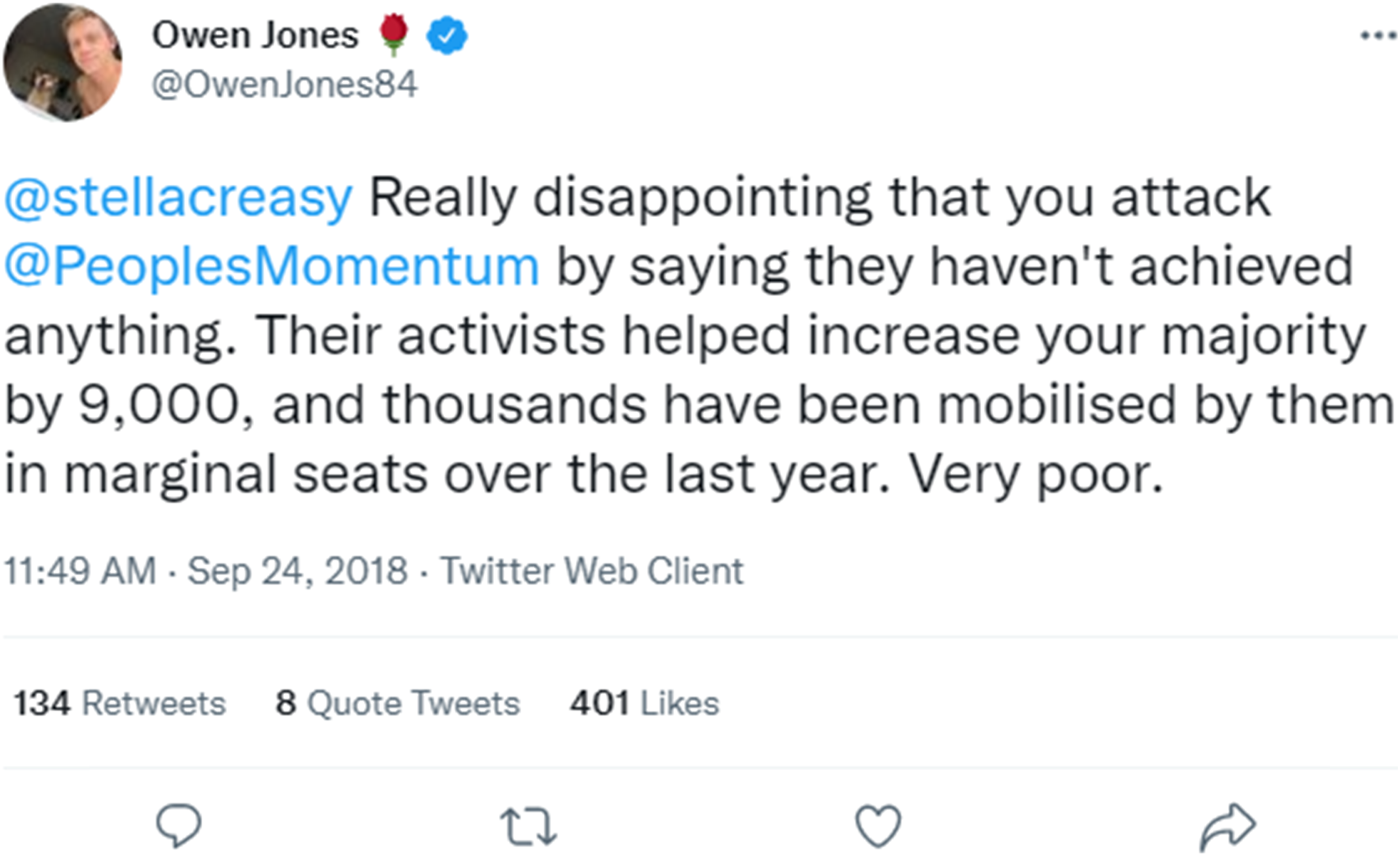
In the 2019 general election, 11% of surveyed Labour activists used the ‘My Campaign Map’, but Momentum subsequently noted their campaign materials were undermined by data built on 2017 expectations and had an urban bias (Labour Together, 2020: 104, 109). Therefore, approaches such as car-sharing through their app may have in fact misallocated resources. Furthermore, whilst Momentum claimed their online strategy in 2019 outperformed the party and filled substantial gaps, an election post-mortem report suggested large swathes of this activity operated in echo chambers, ‘resulting in little reach beyond those who are already supportive of Labour’ (Labour Together, 2020: 95–97). Finally, there are also key issues concerning message control, clarity, and tone. As an interviewed Labour Party campaign organiser observed to me in the run up to the 2018 local elections, ‘once we had one campaign message in our constituency, now it feels like we have about 28’.
Following investigation, Momentum was fined £16,700 by the Electoral Commission for multiple cases of inaccurate financial reporting of their 2017 election campaign. Since then, other non-party groups deemed to have committed offences (in most cases not fined), include HOPE not Hate Ltd, Best for Britain, 3rd Party Ltd, Health Campaigns Together, and Stand Up To Racism (Electoral Commission, 2022). This suggests a clash of logics precipitated by more informal, social-movement style campaigners moving into the formalised sphere of electoral campaigning (Temple and Langer, 2020). Importantly, almost all of this activity is ‘invisible’ in terms of the data used by the traditional spatial-analytic approach in electoral geography.
Whilst Momentum and a handful of others raised and spent enough money to be registered with the Electoral Commission as official non-party campaigners, many campaign groups did not. VAAs, whilst demanding in terms of data and time, can be developed on tiny budgets and shared widely on social media. Digital VAAs are not new (Farrell and Schmitt-Beck, 2008); however, in 2017 and 2019 a greater number than ever before sprang up. Such resources are seen as increasingly important in an era of waning party allegiance. They vary in terms of their partisanship – some are billed as neutral, others as progressive and linked to tactical voting.
Many VAAs use a short survey to help people choose the party to vote for (usually drawn from party manifestos) which raises questions on how these are designed and built and the political and epistemological uncertainties about what this sort of activism means for representation (Fossen and Van der Brink 2015). Furthermore, in socio-political terms, as more VAAs spring up there are questions concerning the degree to which campaigns co-ordinate or not. Choosing the suggested tactical vote in a constituency is not always straight-forward, and campaigns run the risk of providing conflicting advice depending on how they crunch their data and integrate local knowledge.
Assessing just how influential these campaigns are, and the general impact of their proliferation in the electoral landscape, is extremely difficult. To answer questions about how many people and what sort of people use them – and whether they subsequently adapt their political behaviour – requires a lot of thinking about data, methods, and concepts. And, whilst the campaigns themselves acknowledge the difficulty in measuring their impact, they also make claims that they do, for instance, on the Tactical Vote website for 2017: ‘Take Kensington for example: around 7800–15000 people used Tactical vote 2017 to see the recommendation for that seat (Labour) and Labour won by just 20 votes. We are confident that if those 7800-15000 people hadn't used Tactical vote 2017 then the Conservatives would have held on to it’.
The Conservative Party won this seat back in 2019, with a very small majority. Analysing how and if these sorts of campaigns can in fact impact election results is therefore a key issue.
2 Case Study 2 – Facebook Advertising
Public discourse around Facebook advertising took off following the Cambridge Analytica scandal. The idea goes that campaigners ‘micro-target’ through Facebook adverts (and indeed elsewhere) by creating a psychological profile based on demographic and ‘Like’ data and then both target key users and subtly tweak adverts to match their predicted personality type (Bakir and McStay 2017). In the wake of Trump and Brexit breathless media coverage suggested that such ‘dark advertising’ – described as algorithmic, data-driven psychological warfare funded by shadowy corporations - was persuading voters and delivering results (Cadwalladr, 2017). There are multiple problems with this data-dystopia narrative, as Kefford (2021) points out in detail. It’s questionable whether the harvested data really are as sophisticated and useful as these companies claim. But crucially, campaign literature for decades has pointed out just how difficult persuasion is – that is, to get a voter to change their mind and vote a different way. The evidence that campaign advertising can have such an effect is sketchy at best; face-to-face conversation seems the most fruitful avenue for such persuasion, and even that depends on specific circumstances (Kefford, 2021:1–5). The thrust of this discourse is therefore misleading.
It is not persuasion that should be the focus then, but mobilisation. More accurately, de-mobilisation and voter suppression. Analysis in the US by Kim and others (Kim, 2016, 2018, 2022a, 2022b; Kim et al., 2018) innovatively traces digital advert exposure, advert content, and voting behaviour in their sample. Early results suggest that dark advertising tactics focused on disinformation about voting procedures and candidates and were aimed at Democrat-leaning voters (i.e. low income and ethnic minorities) in battleground states. The intention was not getting them to vote for Trump but to dissuade them from voting at all (such results support earlier work showing the demobilising effect of attack adverts, see Ansolabehere et al., 1994). A related strategy appears to have been to sow general discord and confusion by promoting disinformation on divisive and inflammatory issues such as abortion, gun ownership, immigration, and terrorism (Kim et al., 2018). Forthcoming work suggests that exposure to these adverts did indeed lower voting propensity (Kim, 2022). The groups running these adverts operate under the radar of the US Federal Election Commission.
It is worth considering the methodology of Kim et al.’s work that allows such dynamics to be analysed. The study required the installation of Facebook monitoring software on the devices of almost 10,000 volunteers, which recorded five million advert impressions over six weeks. The participants had to be surveyed at key points to capture their demographics, political attitudes, and voting behaviour. Furthermore, the types of adverts, which ran into the thousands, had to be coded and categorised. This enormous endeavour required setting up far in advance of an election and robust analysis of the data takes years. Replication and verification of the findings are also extremely difficult.
This is not to say that before these digital developments it was easy to study campaign effects. However, previous studies were able to gain insight using standard survey techniques, for instance, asking respondents if they had seen political adverts on TV and then comparing voting propensity (Johnston and Pattie, 2006:189–193; Pattie and Johnston, 2002), or, as discussed, comparing party campaign expenditures with constituency results. The campaign information environment is now so highly fragmented, individualised, and informal, that the data which previously gave electoral geographers such ‘delight’ threaten to become either a deluge, or, barely visible at all.
V Discussion
Whilst only scratching the surface of the digitally enabled developments occurring in elections, these examples provide context to throw light on the relations between the digital turn and electoral geography.
Digital technology has empowered the informal aspects of electioneering, in particular non-party actors and their campaigns; it increases citizens’ ability to network, innovate, and spread their message. There has been a rise in both citizen activism and rogue actors seeking to influence elections. The sort of campaign dynamics and effects traditionally focused on by electoral geographers (and political scientists) emphasise the formal aspects of elections and centre on the political party – this makes sense, they are ultimately the vote-seekers after all. However, we should also take the non-party campaign seriously; it is unclear how embedded they are in the electoral landscape and what impact they have. On social media these organisations can appear highly active and vibrant, but that does not have to translate into electoral impact in terms of outcome. From a partisan perspective, they potentially offer not only support and innovation but also competition for activists and can muddy party messaging. From a non-partisan perspective, they can provide valuable advice and promote voter registration drives but might just as easily spread disinformation.
When it comes to the threads of electoral geography, important to reiterate here is that the traditional sort of data analysed under the spatial-analytic approach – surveys, campaign finances, area demographics, results, etc., – will struggle to capture the behaviour of these digitised informal actors. Despite themselves often being quite data-driven in their campaigns, they do not in fact generate data themselves that is easy to analyse quantitatively. Their spatial mediation and subsequent development of differing knowledge politics means that new forms of data collection are needed. Computer science approaches, such as use of APIs to scrape social media to undertake content or network analysis (Gorrell et al., 2019; Kim et al., 2018), can help to try and map and understand the big picture trends. But this will only take us so far. Exploring these campaigns requires complementary qualitative analysis – interviewing, digital ethnography, and the like – to understand motivations, strategies, and rationale, drawing from the field of social movement studies (Mathieu, 2021; Tilly et al., 2019). How to understand who uses these online platforms – something these campaign actors themselves struggle to understand – will be important and require consideration of how to capture these data effectively. Therefore, without combining quantitative and qualitative methodological approaches, much will remain hidden to each separate thread of electoral geography.
A key strength of geographical analysis is contextualisation and comparison. The examples in this paper – drawing from the UK and US – reflect the author’s areas of knowledge and research but continue the Anglo-centric focus of electoral geography. Following previous critiques, this still requires broadening as these digital developments are not guaranteed to play out in the same way in different places. Studies from other contexts are proliferating (examples include India [Basavaraj 2022], Indonesia [Beta and Neyazi, 2022], and Colombia [Vanden Eynde and Madens 2021]), but little work has compared differences. A key area of interest that electoral geographers can therefore contribute to concerns the impact of the electoral system itself; FPTP systems arguably put a higher premium on spatial data as only select areas will swing an overall result. This will likely exacerbate existing inequalities between places and communities in terms of their strategic importance to an election, leading to what have been called ‘data shadows’ in other contexts (Shelton et al., 2014). Therefore, the role of place, and the impacts of the spatial mediation of place, will vary across electoral contexts.
Finally, the digital developments under discussion inevitably prompt renewed scrutiny of the neighbourhood effect. Explanations for the neighbourhood effect were not often about the physical propinquity of voters but rather about the networks of information an individual was embedded in, and perceptions they have of their political context, from the local to the global. The fundamental issue, then, as Agnew (1990) put it, is interpersonal information flow and its impact on voting behaviour, or, the ‘spatially structured sources of political information’ (Johnston and Pattie 2006: 144). The individualisation of knowledge politics is at the core of increasingly digitised elections – does the growing embeddedness of spatial media in communities reduce the neighbourhood effect? In many ways, we might expect it to as many social media platforms connect people at previously unimaginable scales. However, at the same time, people now have more access than ever before to geolocated data about their area. Indeed, this has been used – in often questionable terms – since digital political campaigning began (Dorling et al., 2002). But where do citizens get such information from? Whilst research so far has explored Facebook advertising, an under-explored avenue of research concerns local Facebook groups, which can be highly active political spaces (Spring and D’Urso 2019). These are difficult to target in any automated or systematic way for political disinformation (but not impossible) and also difficult to analyse in any quantitative way; however, these forums have sizable memberships and provide important sources of local information for citizens, potentially informing their voting behaviour.
VI Conclusion
Taking these issues together suggests that digitised spatial mediation and its subsequent knowledge politics have deep and complex implications for electoral behaviour and analysis. The digital turn highlights the requirement for expansion into areas that can handle new quantitative data flows, such as computer science, and that can offer insight into informal campaign practices, such as social movement studies. It prompts the need for intra-disciplinary communication between electoral geographers working within the different analytical threads to better handle the interconnections between new sources of data (and gathering that data) and the behaviours and practices of citizens (Blok and Pedersen 2014; DeLyser and Sui, 2013).
Alongside these considerations, there are of course many more angles to consider moving forward. The discussion here has primarily focused on Left-leaning and progressive non-party organisations, but those operating on the Right are crucial to understand too. As noted, the exploration of case studies from outside the Anglosphere – and comparative analyses – is of importance. And it’s also worth re-iterating a key point of the spatial mediation approach, which is a conceptual move beyond the online/offline dichotomy. It can be tempting when looking at digital technology to drift into a primarily online focus. But just because digital engagement is on the increase does not mean that physical canvassing and campaigning stop. For instance, one of the most widely reported stories in the US 2020 presidential election concerned the voter registration drives of marginalised communities in Georgia and the work of activists such as Stacy Abrams – much of this was traditional door-knocking and mobilisation, approaches which are, as Abram’s spokesperson put it, about much more than the ‘really expensive tech tools’ (Krieg and McKend 2022). However, tech tools – potentially the mundane and cheap ones – will still be playing their part, underpinning targeting, communication, and organisation. Spatial mediation must be considered in all its complexity to get a handle on the nature of campaigning, interpersonal information flow, and subsequent election outcomes.
Finally, a question has perhaps gone begging throughout this paper – in light of the digital developments under discussion, has the sub-discipline of electoral geography had its day? Will studies in political science, which are ever more sensitive to issues of scale, and big data political studies in computer science, render the spatial-analytic thread redundant? Are qualitative analyses of election campaigns better subsumed into political geography more generally and sundered from the disciplinary organisation of electoral geography? I would argue not. A sub-discipline helps maintain a recognisable core; conceptually it helps scholars navigate research, and pragmatically it remains useful for funding and networking (see Sharp, 2004; McGing, 2015). Even though dialogue across the research threads has been limited, the historical evolution of inter- and intra-disciplinarity, and the fact that these multiple threads are there and active, means that the sub-discipline offers a fertile space for methodological bridge building. Indeed, using the digital turn to demonstrate the potential fruitfulness (and pressing need) of such a direction, I have hoped to justify turning our energies to exploring how. The ambition to work across qualitative and quantitative approaches has a long history, and it is moving up the agenda in the social sciences (Maxwell 2016). Other sub-fields in geography have also started this complex conversation (see Bathelt and Pengfei, 2021 in economic geography and Goetz et al., 2009 in transport geography). Arguably, electoral geography is in fact in a prime position to engage with and contribute to these discussions, and doing so offers an opportunity to strengthen its capacity to explore and understand the increasingly digitised electoral landscape.
Footnotes
Declaration of conflicting interests
The author(s) declared no potential conflicts of interest with respect to the research, authorship, and/or publication of this article.
Funding
The author(s) received no financial support for the research, authorship, and/or publication of this article.