
Abstract
Rather than an integrated project of modernity, the provision of energy in Mozambique is characterized by social and territorial fragmentation. Our concern in this article is with spatial-political projects that enlist energy-related infrastructure as a means of furthering national unity across the national territory. We argue that the Mozambican state’s efforts to knit together its territory through energy provision have heightened divisions, such as between urban and rural areas, subnational regions and socioeconomic groups. We draw on geographical political economy and landscape research to consider the space and territoriality of Mozambique’s energy systems. We use the lens of energy landscapes to examine the spatialities and historical legacies of energy-related infrastructural state projects, and how such spatialities and legacies shape new energy projects. These landscapes are material expressions of the social, political and institutional relations bound up in energy extraction, distribution and consumption. They reflect historical legacies, revealing traces of successive developments. While previous studies have focused on local energy landscapes in a variety of settings, our aim is to examine how such landscapes connect with wider nation-building projects and the operation of political economies. To elucidate these points, we examine two energy-related projects and their landscapes in Mozambique: Cahora Bassa hydropower dam and the Moatize coal extraction zone. The article concludes by reflecting on the ways in which energy landscapes can be used to interrogate the dynamics of power inherent in energy systems, the evolving links between state power and electric power, and the interests being served by these developments.
Introduction
In 1988, an article published in Politique Africaine described the Cahora Bassa hydroelectric dam in Mozambique’s central province of Tete as a ‘paralyzed colossus’ (Ollivier, 1988). The largest project representing the modernizing aspirations of the Portuguese colonial government, Cahora Bassa became a symbol of spatial imposition and socio-environmental transformation for the Mozambican independence fighters during its construction in the early 1970s. The project displaced thousands of Mozambicans, and Frelimo (Frente de Libertação de Moçambique – Mozambique Liberation Front), then leading a guerrilla war against the Portuguese, attacked the construction site repeatedly, viewing it as a strategic asset of the colonizers. It became the great ‘white elephant’ and an infrastructural symbol of imperial dominance (Isaacman and Isaacman, 2013).
After gaining independence in 1975, however, the Frelimo government turned its interest to the electricity generating giant. Samora Machel, the first president of independent Mozambique, argued for the need to harness it as an asset vital to the success of the liberated country (Isaacman and Sneddon, 2000). Although the company managing the dam, Hidroeléctrica de Cahora Bassa (HCB), remained under majority Portuguese ownership until 2007, the Mozambican government participated in extracting value from it. Mozambique still sells most of HCB’s output to South Africa and the Southern African Power Pool, with only a small portion remaining for domestic consumption (EDM, 2018; World Bank, 2015).
As such, the structure of the landscape today reflects both historic attempts to deliver modernity-making projects and their continuous fragmentation when these projects encounter the realities of energy production and use. Mozambique faces substantial challenges in reaching its goal of universal energy access. Recent estimates suggest that only 26% of Mozambique’s 28.8 million inhabitants have access to electricity (EDM, 2017; INE, 2017), while less than 5% can access clean and sustainable fuels (Global Tracking Framework, 2017), one of sub-Saharan Africa’s lowest energy access rates. Simultaneously, Mozambique is a major exporter of hydropower, coal and natural gas (IEA, 2014), with the aim of becoming southern Africa’s energy hub (EDM, 2018). This brief overview of the country’s energy situation suggests that the political economy of energy in Mozambique is intermingled with the spatiality of the country’s energy systems, their historical legacies and prospective futures.
This article investigates the ways in which energy systems are visible in the landscape while also transforming landscapes. For our purposes, ‘energy landscapes’ reflect the spatial arrangements of energy systems accumulated over time in particular places (Castán Broto, 2019). Our particular concern is with political-spatial projects that enlist energy as a means of furthering national unity across the national territory. We will argue that the Mozambican state’s efforts to knit together its territory through energy provision have served to heighten divisions between urban and rural areas, subnational regions and socioeconomic groups. In the process, new geographies of connectivity and exclusion are unfolding through resource development, energy flows and everyday patterns of energy provision and use (Argent, 2017; Bridge, 2009). We draw on geographical political economy and landscape research to examine the spatial arrangements and historic legacies of state-led energy infrastructural projects, and how these histories and spatialities shape new energy projects. In Mozambique, national modernity-making projects intersect with the actual practices of energy production, provision and use (Castán Broto, 2017b). The resulting energy landscapes are not static or predetermined but rather diverse and in flux, with local expressions produced by the intersections of space, energy systems and social practices. Energy landscapes provide a material terrain that shapes the ways different energy technologies are configured across various conditions, with implications for how we might understand the geographies of energy transitions (cf. Bridge et al., 2013). By doing so, we extend the notion of energy landscapes as an analytical lens to study broader regional and national transformations.
The article proceeds by outlining the conceptual basis for our analysis of energy landscapes in Mozambique, followed by a discussion of state legitimation strategies through energy projects. This framework enables a detailed analysis of particular energy landscapes in Mozambique, looking at two specific sites linked to the expansion of the electricity grid and coal exports. The article suggests that a multitude of contingent practices constitute energy landscapes, with different results in different locations across the country. This leads to uneven patterns of development, and unsettles governmental efforts to exert territorial control. The article concludes by reflecting on the ways in which energy landscapes can be used to interrogate the dynamics of power inherent in energy systems, the evolving links between state power and electric power, and the interests being served by these developments.
Methodologically, the study is supported by field observations, 16 semi-structured interviews and unstructured conversations with public officials and residents during field visits to Maputo and Tete in 2012, 2013 and 2014, as well as follow-up unstructured interviews with representatives of key institutions in the energy sector and international donors in 2017 and 2018. Our research included visits to mining-related sites in Tete and Moatize district, including the offices of Vale and Rio Tinto, Rio Tinto’s job training centre, the provincial directorate of mineral resources and energy, and the resettlement site of Cateme. One of the authors frequently travelled from Tete to Moatize on chapas (privately run minibuses), making detailed notes of landscape features along the EN103 road. This was repeated from Tete to Songo, in Cahora Bassa district, where this author interviewed HCB officials, employees and local residents. This primary data is supplemented by online sources including Electricidade de Moçambique, E.P. (EDM)’s and HCB’s websites and annual reports, while drawing on extensive previous research in the country by all the authors.
Energy landscapes: A critical perspective
In this section, we aim to bridge the spatial, temporal and symbolic dimensions of energy landscapes with the broader political economy of energy production and consumption. Recent work in energy geographies has developed the notion of ‘energy landscapes’ as reflecting the spatial arrangements of energy systems accumulated over time in particular places (Castán Broto, 2019). While previous studies have mostly focused on local, place-based and resource-related struggles (Bouzarovski, 2009; Castán Broto, 2017a; Tschakert, 2016), there is less understanding of how energy landscapes connect with wider nation-building projects and the operation of political economies. In this section, we propose to investigate these connections by examining energy landscapes as shaping and reflecting strategic energy projects and contingent energy practices. To this end, we turn first to an examination of energy landscapes as an analytical lens and then to its relationship to energy infrastructure provision as central to state political projects.
Much of the work on energy landscapes draws on broader, interdisciplinary landscape theory and research (Cosgrove, 1998; Duncan, 2007; Wylie, 2010). This interdisciplinary research has characterized landscapes as expressions of socio-ecological relations in three distinct ways. First, the idea of landscapes as a ‘way of seeing’ highlights how perceptions of landscapes reflect social relations of domination. Accordingly, relations of capitalist production bear their imprint on landscapes, reflecting the material transformations of capitalism and the social relations that make them possible (Mitchell, 2003). Landscapes thus enact and reproduce systems of power and authority (Duncan, 2007). Second, this scholarship has also suggested that landscapes are dynamic and performative, resulting from everyday actions that operate alongside, but sometimes outside, dominant relations. Landscapes result from the multiple processes through which humans and non-humans inhabit the world (Ingold, 2000; Olwig, 2002). In this conception, landscape is a lived, evolving web of pathways and dwelling places (Wylie, 2010). Third, bridging both perspectives, landscapes connect experience and memory with political histories in particular locations. Landscapes are actively involved in processes that embed memories, collective histories and ‘institutional debris’ in the fabric of the Earth (Rasmussen and Lund, 2018: 395; Selman, 2010; Tolia-Kelly, 2011). In sum, the reading of landscapes exposes the spatial arrangements and material legacies of political projects and associated struggles, their memories and everyday actions and experiences accumulated over time in particular locations.
Drawing on these insights, scholars have used the lens of energy landscapes to examine the spatial arrangements and material legacies of processes of energy extraction, conversion, distribution and consumption, including how these have been maintained and contested over time (e.g. Castán Broto, 2017a; Haarstad and Wanvik, 2017). Energy landscapes are spaces created by material expressions of particular regimes of energy resources, infrastructures and the institutional and cultural practices associated with them (Castán Broto, 2017a; Nadaï and van der Horst, 2010; Schafft et al., 2019). In this vein, Bouzarovski (2009) provides a framework for understanding the production of energy landscapes in eastern and central Europe in relation to the historical relations of post-socialist transition, and through the integration of regulatory technologies that are transferred through global circulations and political ordering. Energy landscapes thus consist of ‘natural and cultural features across a broad space and the history of their production and interaction’ (Bridge et al., 2013: 335). As such, energy landscapes constitute a visual record of the political economy of energy systems and the power relations embedded in them.
Correspondingly, energy landscapes are also dynamic registers of energy systems’ multiple trajectories and the everyday practices associated with them. Scholars of urban energy landscapes have shown the layered, and at times fragmented or even conflicting, expression of energy production, distribution and consumption practices in the built environment of cities (Abi Ghanem, 2018; Baptista, 2019; Castán Broto, 2017a; Luque-Ayala and Silver, 2016; Monstadt and Schramm, 2017; Rutherford and Coutard, 2014; Silver, 2014). Other scholars have suggested that energy landscapes are contingent, characterized by instability and disruption, and thus open to change. Haarstad and Wanvik (2017), for instance, use the notion of ‘carbonscapes’ to question the inevitability of energy-society relationships. These authors use the vocabulary of assemblages to explore stability and change in carbonscapes, which have materially and socially embedded fossil-based infrastructures over many years. In their view, change is not ‘dependent on some future overthrow of the “system as a whole”’, but instead occurs ‘by way of reconfiguration, adaptation and conversion’ (Haarstad and Wanvik, 2017: 441). Thus, rather than thinking of energy landscapes as materializing from specific, large-scale projects, such as the example of Cahora Bassa dam in Mozambique, they are enacted through multiple features, which may include such large projects, alongside everyday practices of place-making and territorial control.
Nevertheless, energy landscapes embed the experiences, meanings and memory of such large schemes in particular locales, not least because energy projects often convey particular political projects, structures and imaginaries of the state (see Hecht, 2009; Perreault and Valdivia, 2010). Among the different forms of energy provision, electricity has been particularly associated with state-building, national development and modernization schemes (Hecht, 2009; Labban, 2012). For example, representations of the energy network as underpinning a project of modernity have been central to postcolonial projects of independence (Kale, 2014). By expanding grids, African states and leaders increase their visibility among local populations, at least in rhetorical form (Boyer, 2014; Power and Kirshner, 2018). Some of this work draws on landscape-oriented writings on the geographical imagination (van der Horst, 2014). In this view, electricity is a commodity with distinct space-time features, produced in one location and instantaneously consumed in distant locations (van der Horst, 2014). Efforts to gain political authority are often expressed in landscapes, for example, as they are made visible in ‘the fixed physical infrastructure that enables [electricity] transport and utilization’ (van der Horst, 2014: 68). In sum, energy landscapes are also symbolic representations of broader political state projects through infrastructures and the wider political economic contexts in which these take place.
The connection between energy projects and state-building in Africa is well rehearsed. Many observers considered large-scale infrastructure – power stations, oil pipelines, railways, equipment depots, highways and irrigation systems – an imperative to modernizing new nation-states in the postcolonial 1950s and 1960s (see Cooper, 2002). During the period of rapid decolonization, some leaders and independence movements hailed conventional energy sources (coal, oil, gas) as key means of spurring industrialization and mobilizing a sense of national identity (Showers, 2011; Winther, 2008). By gaining effective control of a country’s energy sources and infrastructures, according to this view, political classes could reaffirm their independence vis-a-vis former colonial powers and fulfil expectations for national progress and modernization (Showers, 2011). Infrastructural networks were also central to postcolonial urban planning regimes in African contexts, lending shape to a modernist vision of development (Freund, 2007; Pieterse et al., 2018). These efforts were thoroughly informed by Western imaginaries of centralized infrastructure development and management, and universal service (see Graham and Marvin, 2001). Scholars have subsequently questioned whether this model can apply to countries in the global South, where such ideals were rarely achieved (Coutard, 2008). More recently, researchers have shown how fragmentation and heterogeneity are inherent to infrastructure systems (Jaglin, 2016; Monstadt and Schramm, 2017).
Indeed, many of these modernizing aspirations have failed to materialize across sub-Saharan Africa, not least regarding electrification. In many sub-Saharan African states, the electricity sector faces a daunting set of capacity and infrastructure-related barriers, including low generation capacities, inefficiency, price volatility, unstable supply and truncated access rates (IEA, 2014). These dynamics carry over to fuels. Sokona et al. (2012: 4) observe that although there is an urban/rural divide in terms of distributions of energy systems and practices, ‘the boundary is not clearly demarcated’ in lived experience. Accordingly, energy systems are subject to fragmented governance. Policymakers have struggled to coordinate interventions around household cooking, electrification and mechanization needs in agriculture into long-term, integrated planning (Hafner et al., 2018). The challenge also reflects the divide between urban and rural development planning and the everyday realities of these spaces. Furthermore, it points to the importance of recognizing new social and material practices of acquiring and using energy, produced by new technologies and their configurations, and how people interact with them (Castán Broto, 2017b, Abram et al., 2019).
Overall, these analyses have implications for the ability of sub-Saharan African states to promote and sustain their legitimacy through energy projects. Such challenges are particularly visible and can be read off the energy landscapes that have evolved over time in particular places. We now turn to these challenges to state legitimacy in Mozambique and the related energy landscapes in the next section.
Mozambique’s state legitimation through energy projects
Frelimo é que fez; Frelimo é que faz.
(Frelimo is who did it; and Frelimo is who does it.)
Electoral campaign slogan, 2014
The constitution of a modern state – clean, rational and productive – was central to the post-independence Frelimo government in Mozambique. Underlying this vision was Frelimo’s positioning as a vanguard party, itself shaped by foundational ideas of non-racial, non-ethnic and non-regional ‘national unity’ (Hanlon, 1984; Pitcher, 2002). Frelimo underemphasized the expression of identity and territorial differences, which they saw as key to the colonial regime (Cahen, 2006; Macamo, 2017). In fact, under Portuguese rule, in the 19th and early 20th centuries, the territory that was to become Mozambique was divided into separate concession areas and governed by charter companies, often British (Newitt, 1995). Deep divisions between the northern, the central Zambesi valley and the southern regions emerged. Geographical constraints to an integrated national development strategy also stemmed from the location of the capital in the extreme south, isolated from the rest of the country, and the development of infrastructure networks (e.g. railway corridors and roads), which linked regions of the country to their inland neighbours (South Africa, Zimbabwe, Malawi) rather than to interior regions (Newitt, 1995). The vision of national, territorial unity was part and parcel of Frelimo’s post-independence state legitimation project (Sumich, 2010).
While Frelimo has since maintained a relatively durable regime, tackling this fragmentation was made more difficult due to two particular challenges. First, Frelimo’s territorial authority was challenged by the entrenched civil war against then rebel group Renamo (now the main opposition party), a conflict that ended only in 1992. Since the late 1970s, Renamo controlled large (primarily rural) areas for extended periods (see Geffray, 1991). The consequences of this conflict are still felt today. In 2013, Renamo began attacking government forces amid difficult negotiations over electoral processes and access to energy resource rents (Azevedo-Harman, 2015; Wiegink, 2018). Second, the unsuccessful economic policies of the post-independence regime, compounded by the 1980s structural adjustment programmes that followed, constrained Frelimo’s ability to invest in its modernization project (see Pitcher, 2002). Even with the economic liberalization that followed the post-war transition from socialism to multiparty democracy, state-led investment in much needed infrastructure remained piecemeal. In many cases, the priorities of foreign investors and aid donors, which make up a significant portion of Mozambique’s state budget, led the way. The discovery of extractive energy resources has created opportunities for resource rents through major infrastructural and logistics projects (Castel-Branco, 2014; Hanlon, 2004; Wiegink, 2018). These energy resource rents have been increasingly captured by Frelimo-linked domestic business elites, who participate in various energy-related projects as shareholders and local partners for foreign investors (Macuane et al., 2018). This has widened inequalities and class stratification (Castel-Branco, 2014), thus overshadowing Frelimo’s initial attempts at modernization and national unity.
Similar dynamics of fragmentation and rent seeking can be observed when looking at Mozambique’s energy system and energy-related projects. After independence, the Frelimo-led government sought to use energy infrastructures as part of the larger transformative project of national unity and modernization. The political fragmentation of the colonial territory was also visible in how the electricity network developed as three distinct ‘systems’: one system in the south, around Lourenço Marques (the colonial designation of Maputo); another system in the centre, associated with the city of Beira; and a third ‘system’ consisting of dispersed urban centres, but largely disconnected from each other (hence a ‘system’ only in metaphorical terms) (see Baptista, 2017). As noted in the introduction, the Cahora Bassa dam was to play a key role in the state’s project of national unity, but it would also require the integration and expansion of the fragmented colonial electric grid.
To this end, the government created a state-owned electricity utility, Electricidade de Moçambique, E.P. (EDM) in 1977, integrating some 26 dispersed colonial production and distribution units (Baptista, 2017). The government mandated EDM to support national development and citizens’ wellbeing, but this was significantly curtailed until the end of the civil war in 1992. From 1995, EDM began to expand the domestic grid, with support from the donor community, regional partners and foreign investment (Baptista, 2017). Since then, the grid has expanded substantially (see Figure 1), connecting all provincial centres and all 128 districts (as of 2014). However, several limitations remain. The existing network bypasses extensive rural areas, where the low-density and low-income population makes it difficult and costly to connect people to the grid (see World Bank, 2015). The northern-most province, Cabo Delgado, depends largely on a single transmission line, such that one failure on the lines is enough to cut electricity to a vast area (EDM, 2017). The low electricity access rate of 26% remains a key problem in the country’s economic development and social wellbeing. Electricity access rates also vary considerably from urban to peri-urban to rural areas and by province (EDM, 2017). Moreover, urban population growth has outstripped the pace at which households are connected to the grid (Cipriano et al., 2015; cf. Brew-Hammond, 2010). Since 2011, amid an upsurge in domestic demand, there have been supply deficiencies and the load has exceeded capacity (Cipriano et al., 2015). These dynamics suggest that EDM has a major challenge on its hands if it is to fulfil the state’s drive for national unity through the electric grid.
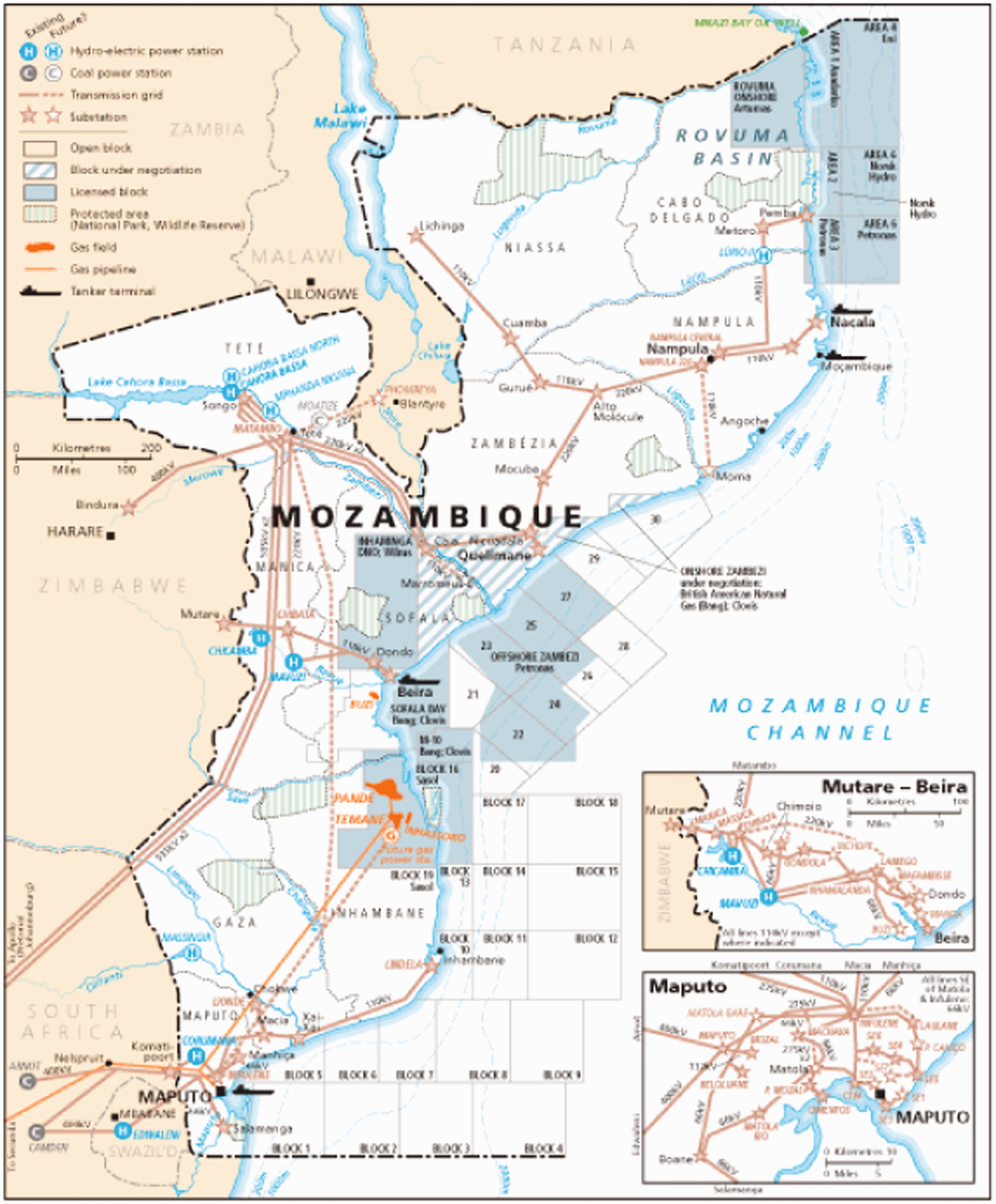
National electricity grid network in Mozambique.
Part of this challenge relates to the limited production of energy and the state’s inability to promote generation infrastructures. Hydropower is Mozambique’s primary energy source, accounting for about 77% of all electricity generated (EDM, 2017), and a combined capacity of 565 MW (Cipriano et al., 2015). In recent years, a number of gas power plants run by Independent Power Producers (IPPs) have contributed to mitigate this shortfall, but at a higher cost to EDM than it can recover from current electricity tariffs (World Bank, 2015). With the economic liberalization of the 2000s, investments in the exploitation of hydrocarbon resources to build coal and gas power plants indicate the growing appetite in Mozambique for using carbon-centric sources for domestic generation and export. Through these large-scale foreign investments, the state intends to reduce long-term aid dependence while developing untapped, frontier markets (Castel-Branco, 2014; Pérez Niño and Le Billon, 2013). Even though many of these projects have been slow to take shape on the ground, plans for their implementation risk pushing more sustainable sources out of the energy mix and entrenching high-carbon sources in Mozambique’s contemporary infrastructures and economies. Such shifts suggest the socially contested and power-laden features within energy systems (Newell and Mulvaney, 2013) and the ways in which control over particular pathways can be maintained ‘across material, institutional and cultural spheres of power’ (Johnstone and Newell, 2017: 7).
These changes in the political economy of the state’s energy infrastructure projects have yet to significantly transform everyday energy practices on the ground. The majority of the Mozambican population remains dependent on fuelwood (in rural areas) and charcoal (in urban areas), especially for cooking (Castán Broto, 2017b; Cuvilas et al., 2010). The consumption of biomass is of concern to authorities because of rapid deforestation, particularly within the hinterland of major cities. Fuel supply chains remain entirely disconnected from the electricity generation and distribution systems and the extraction of resources such as coal or natural gas (see Mavhunga, 2013). In sum, fragmentation, rather than a coordinated project of modernization and national unity, remains the main feature of Mozambique’s energy landscapes. In the two sections that follow, we engage with an examination of two energy-related projects and their landscapes – the Cahora Bassa hydropower dam and the Moatize coalface – and explore how these reflect the spatial, temporal and symbolic dimensions of the broader political economy of state legitimation through energy production and consumption.
Cahora Bassa, EDM and grid expansion
At the heart of Mozambique’s energy system is Cahora Bassa, the giant hydroelectric dam on the Zambezi River in Tete province, which opened in 1977. Colonial planners viewed Tete as a frontier, far removed from centres of population and economic activity (Newitt, 1995). Framed in high modernist discourse (see Scott, 1998), colonial authorities unveiled the dam project as a testament to Portugal’s commitment to remain in south-eastern Africa and enhance infrastructure in the region through large-scale hydroelectricity generation (Isaacman and Isaacman, 2013). Construction began in 1969, with the project financed by foreign investors and the guaranteed sale of electricity to South Africa at below-market prices, in exchange for its support in the colonial war (Isaacman and Isaacman, 2013, 2015).
Despite Frelimo’s hostility to the dam as a means to perpetuate white minority rule in the region and its attempts to sabotage it, Cahora Bassa was completed six months prior to Mozambican independence. As noted in the introduction, when Frelimo took over the reins of power in June 1975, it shed its objections to the dam, seeking to turn an exploitative colonial project into a national developmental asset (Isaacman and Isaacman, 2015). While many felt it represented a ‘white elephant’, President Machel argued, ‘This elephant has to provide our agriculture and industry with the ivory that are [sic] electricity and irrigation’ (Machel, 1979: 36). Although its principal aim was to export power to South Africa and attract foreign exchange, Frelimo attempted to coax peasants to its planned rural villages with the promise of electricity (Geffray, 1991), while incorporating the dam into its vision of socialist modernity.
With limited access to capital, however, the Mozambique government agreed in 1975 to holding a minority position in HCB, leaving Portugal to control an 82% stake (Ollivier, 1988; Sebitosi and da Graça, 2009). Decades later, in 2007, the Mozambique government signed an agreement to reverse the dam’s ownership from majority Portuguese to Mozambican state ownership of 85% (later rising to 92.5% in 2012). The government also announced its intention to construct a new hydroelectric dam at Mphanda Nkuwa, 70 km downstream from Cahora Bassa, a project that had been on the cards since the 1990s.
When the Mozambican state assumed control of Cahora Bassa, it sparked expectations that it would foreground domestic energy needs (Power and Kirshner, 2018). The slogan, ‘Cahora Bassa is ours!’ proclaimed by then President Guebuza, aimed to inspire national unity based on these prospects (Isaacman and Isaacman, 2013). Yet, a high proportion of the dam’s output continues to be exported. Cahora Bassa has a capacity of 2075 MW, of which 1500 MW (or 70%) is committed to South Africa’s Eskom utility under a long-term agreement through 2029 (EDM, 2018: 16). Cheap power fizzes into South Africa on high-voltage lines directly connecting to Pretoria, with a portion re-imported into southern Mozambique on lines owned by Eskom (Cipriano et al., 2015; EDM, 2018). In 2017, the state unveiled plans to list HCB on the Mozambique stock exchange and sell 7.5% of its shares to investors (All Africa, 2017). HCB also said it plans to expand sales to Malawi, Zambia and Tanzania (All Africa, 2017).
Notwithstanding its use by the state as an emblem to affirm development and assert spatial control through a hydroelectric landscape of tamed water, the electricity produced at Cahora Bassa has yet to be significantly mobilized to power Mozambican society. This condition reflects the wider difficulties of postcolonial African states in generating capital for infrastructure investment, and the contradictions of expressing a national ‘infrastructural ideal’ without being able to guarantee universal service provision (Brew-Hammond, 2010). It also resonates with Herbst’s (2000) thesis on the challenges of state consolidation in Africa, in which relatively low population densities and vast physical expanses have impeded many African states from projecting their power over geographic distance. It has proven particularly difficult and costly for states to extend power in sparsely settled rural areas, where many citizens live (Herbst, 2000).
Amid such limitations on state building in the Mozambican case, EDM has drawn on Cahora Bassa to sustain grid extension. The resulting landscape reflects centralized state-led practices. As a state-owned company, EDM is closely linked to Frelimo. 1 EDM plays a key role in grid extension and related provision of new electric infrastructure, including transmission lines, power plants, substations, transformers and household connections. Siting decisions are centrally managed by EDM in its Maputo headquarters in coordination with the central government. These tend to prioritize areas of high demand in main urban centres. The rapidly expanding urban peripheries have had to wait long periods of time for the grid to reach them. Many people settling in these urban peripheries have needed to resort to solar home systems and other alternatives if they want electricity. Expanding the grid to new areas would fall under EDM’s ‘social mandate’, but would also widen its debt burden (Baptista, 2017). Universal grid extension thus requires a long-term horizon with low rates of return.
Despite the potential for implementing decentralized, off-grid energy systems in diverse geographical settings, energy policy in Mozambique has assumed a spatial separation between rural and urban areas. This situation has effectively translated into two models of energy provision (Castán Broto, 2017b). One model, led by EDM, focuses on expanding the grid, largely in urban areas. The other, managed by Mozambique’s National Energy Fund (FUNAE), a public agency under the Ministry of Mineral Resources and Energy, focuses on delivering off-grid renewables in rural areas. The binary model reflects the constraints on centralized supply and emerging donor priorities. But it is complicated by lived realities, as both centralized and decentralized modes of provision may coexist in rural and urban areas, and sometimes both are absent (Castán Broto, 2017b). Further, neither model addresses the consumption of charcoal and fuelwood, which are deeply embedded as fuel sources across urban and rural regions (Castán Broto, 2017b; Cuvilas et al., 2010).
Moreover, the Mozambique government and EDM’s push for grid-based electrification has sidelined other supply options. These include solar micro-grids, ground-mounted solar PV plants or stand-alone systems to meet underserved energy needs at multiple scales and locations. This is beginning to change, as suggested by EDM’s investment in a 40.5 MW photovoltaic power extension in Mocuba district, Zambézia province, Mozambique’s first utility-scale solar project, initiated in 2018 (Club of Mozambique, 2018; EDM, 2018). 2 However, many peri-urban residents lack grid access and fall outside FUNAE’s state-subsidized rural energy initiatives. Renewable sources are abundant and well distributed in Mozambique – with high levels of solar irradiation in particular – reducing the need for major new investments in conventional transmission networks (DFID Mozambique, interview with authors, 2 June 2017).
Yet, the coverage of off-grid systems remains modest (Ahlborg and Hammar, 2014; EDM, 2018; World Bank, 2015). By agreement with EDM, FUNAE only works in areas projected to be over 10 km from the grid within five years (FUNAE official interview, 28 July 2014). Adding to the challenges surrounding off-grid energy, grid access has become a symbol of full citizenship and recognition, as in many African countries (Brew-Hammond, 2010). Grand, national energy visions spurred by large infrastructure are less easily achieved through decentralized energy and landscape governance (Nadaï and van der Horst, 2010). Furthermore, although these alternative forms of supply are available and are being promoted by development agencies and many scholars, many Mozambicans seem to accept them only as intermediate, temporary steps to being connected to the grid.
Overall, what the example of the Cahora Bassa hydropower dam exemplifies is the continued piecemeal ability of Frelimo to mobilize the energy giant to its project of national unity. A look at the town of Vila do Songo, located near the dam, can further elucidate the ways this fragmentation can be read off its localized energy landscape.
Energy landscape 1: Vila do Songo
Beside Cahora Bassa dam, the regional landscape of Vila do Songo (or Songo), a town that seems detached from its surroundings, reflects a wider separation, an HCB-led enclave that is more closely attached to South Africa’s economy – via high-voltage transmission lines – than to Mozambique’s (cf. Isaacman and Isaacman, 2015). The 300 m-wide and 160 m-high Cahora Bassa dam was erected in a narrow gorge of the lower Zambezi River. During its construction from 1969 to 1974, the contractors’ installations and financial services were set up in Vila do Songo, a town purpose-built to accommodate the personnel working on the dam and hydroelectric project (The Economist, 1972). Songo sits on the Songo plateau, 6 km south of the dam and power station. It has a spacious layout with broad, paved roads linking a series of decentralized neighbourhoods with little visible centre. This contrasts with many Mozambican towns of similar size, which feature compact grid layouts, central plazas and traders dotting the streetscapes of formally planned centres.
Nowadays, there is a central shopping plaza with several ATMs, a supermarket and a post office. The HCB substation looms on the town’s outskirts, while HCB headquarters sits nearby in a leafy residential area, with its private Centro Social (community centre), sports fields, three swimming pools and two tennis courts. HCB owns a housing stock of some 600 houses for its employees, distributed in several blocks, including eight houses for the board of directors. The HCB housing is laid out in categories corresponding with employment rank, such as senior managers, specialized technicians and workers (HCB employee interview, 12 July 2013). HCB reserves additional housing for visiting district government officials. Overall, there is a feeling of spatial order, income segregation and stratification of uses, all stemming from the town’s original purpose as a site for the dam workers. Rather than a planned village, Songo appears more like a gated community.
By day, Songo languishes, with little activity on the streets. At night, the bass thud of several nightclubs is audible, and the major roads are illuminated. Outside the nightclubs congregate groups of smartly dressed HCB employees. The other main visitors to Songo are a trickle of sport fishing enthusiasts, mostly South Africans. Apart from producing electricity in quantity and at low cost, the dam created an artificial lake of 5180 km2, which, among other regional development purposes, was intended to ‘promote the establishment of fishing and tourism industries’ (The Economist, 1972). The South African-owned Ugezi Tiger Lodge, one of the few tourist accommodations, feels deliberately rustic with its detached cabins. It sits on the lakeshore 3 km from the dam’s mouth and attracts anglers with its fishing and birdwatching opportunities. By all appearances, such visitors are rare.
The road from Tete to Songo (roughly 130 km) stretches through arid, low-lying plains of the Zambezi Valley, covered in acacia scrub and occasional baobab trees, punctuated by dispersed, thatched villages and machambas (cultivated plots) of corn and beans. Goats run unhurriedly along the road. Sharply ascending to the plateau 5 km before reaching Songo, the dry fields change to wooded, green and boulder-strewn hillsides. It takes nearly four hours to reach Songo from Tete on the ungraded road. Chapas (mini-buses) stop frequently, finally terminating at a perimeter road. Official authorization was required to enter Songo in the 1980s and 1990s due to security concerns (HCB employee interview, 12 July 2013); a letter of approval from HCB is still needed to visit the dam and power station.
With its well-kept asphalt and beaten dirt roads, spotless walkways, gas stations, brightly lit nightclubs and enormous HCB substation, Songo appears a world apart from other Mozambican towns. Yet, in the surrounding villages beyond the perimeter road, the streets are dark at night, while others are lit by poles equipped with solar panels. The 600-kVA generator that was supposed to supply electricity to outlying villages had failed during one of the authors’ visits in October 2013. Small generators and kerosene lamps, made of tin, served as alternative lighting sources on Songo’s edge.
Hydropower generation and distribution has ramifications in the surrounding energy landscape in both obvious and subtle ways. There is a sense in which the massive dam is a violation of the landscape, through its sheer size and alteration of the waterways. Yet, since independence, rejection or protest over the dam and its destructive social and ecological effects has been muted, as developmental narratives and debates over ownership and energy exports have taken precedence. Residents of informal settlements in the distant capital, Maputo, speak of Cahora Bassa with pride (workshop with residents in Chamanculo C, July 2014). Cahora Bassa has acquired an iconic, even monumental, status in this transformed landscape, transcending its role in energy production and export through the promise of progress and modernity. As such, it is an expression of Frelimo’s particular idea of a modern society and nation while benefitting those loyal to it, not least through HCB jobs and company housing, notwithstanding its divergent and patchwork effects on the ground.
At the Moatize coalface: Mozambique’s coal extraction zone
If Cahora Bassa was a symbol of modernization that has lingered since independence, a new energy frontier rose to prominence not too far way, in the town of Moatize. With the rise of global commodities prices in the mid-2000s, coal operations at the Moatize coalface regained attention from Frelimo, its business elites and foreign investors. The (re-)opening of this new frontier market created a land rush, while various types of infrastructure have become imperative to generate energy, transport and export products, accommodate newly contracted workers, and facilitate urban consumption (see Sassen, 2013). The town of Moatize and the city of Tete (all located in the landlocked province of Tete) exemplify new landscapes in the making through coal operations.
A signpost reading ‘Bem-vindo a Moatize’ welcomes visitors to the town. Many investors have acclaimed Moatize as having the world’s largest untapped coal reserves (Besharati, 2012; Mosca and Selemane, 2011). Moatize, a district capital, 3 sits 35 km from the provincial capital, Tete city, with some 350,000 residents (INE, 2017). It is part of an expanding frontier of extraction in Africa, having received, in 2004, some US$2m in initial investment from the Brazilian mining giant Vale. The coalfields of Moatize had been productive since the 1920s. After independence, East German technicians provided assistance to develop extractive techniques in the early 1980s (Bucuane and Mulder, 2007). But prospects for investment, exports and growth were not considered promising until the mid-2000s, when systematic exploration led to the discovery of vast deposits of high-quality coking coal (Bucuane and Mulder, 2007).
Vale began operations in 2008, aiming to ramp up production and to supply markets in South and East Asia and the Gulf states. An influx of capital investment, technicians and job seekers ensued (Kirshner and Power, 2015; Mosca and Selemane, 2011). But these developments stalled amid plummeting global coal prices from 2013. Compounding this was the recognition of infrastructural gaps and resurgent political conflict in the central provinces (Azevedo-Harman, 2015; Wiegink, 2018). In 2011, Vale was joined by Rio Tinto, the UK-Australian metals and mining corporation. Rio Tinto’s stint in Moatize was short-lived, abruptly selling its Mozambique assets in 2014 to International Coal Ventures (ICVL), a newly formed joint venture made up of three state-owned Indian coal firms. 4 These disruptions eroded revenues and profit margins for investors and the government, casting doubt on future investments. Since 2017, some recovery has occurred as coal prices lifted.
From 2011, major multinationals – Vale, Rio Tinto and India-based Jindal – were transporting coal from Moatize to Beira port, for overseas markets, through the Sena railway corridor (see Figure 2). Increasingly, traffic has shifted north to the Nacala Corridor, inaugurated in May 2017, along with the newly rehabilitated Nacala port (Wiegink, 2018). The Nacala Corridor, Vale’s largest investment outside of Brazil (at US$4.4bn), is envisioned as an ‘integrated logistics corridor’ linking northern Mozambique, southern Malawi and the Moatize coalfields – a new regional landscape. These developments suggest investors’ belief that coal and other extractive resources will catalyse spatial readjustment and new ‘growth points’, including Tete city, Nacala’s historically underutilized, deep-water harbour and the port of Beira, managed by Cornelder de Moçambique. 5
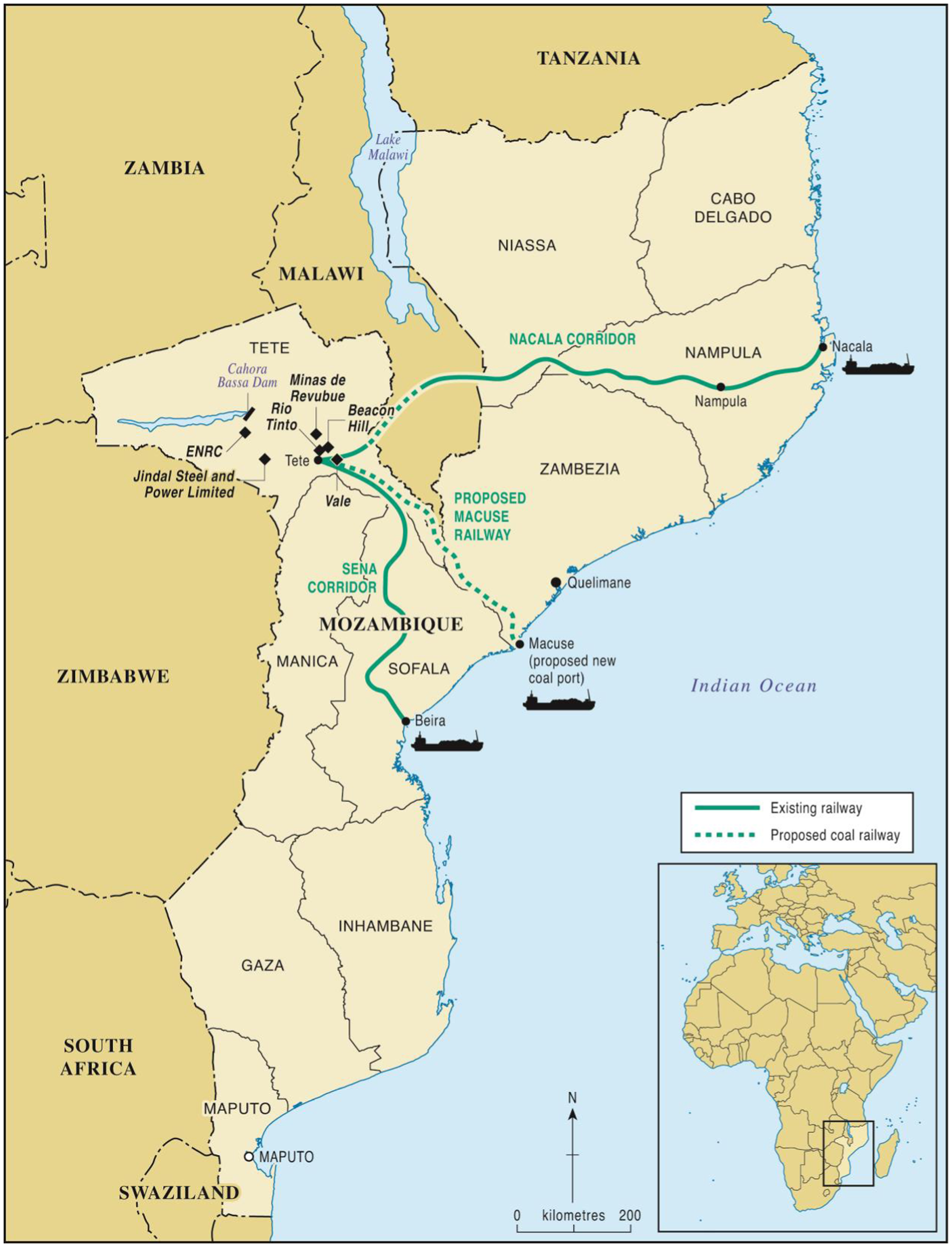
Location of coal extraction and transport infrastructure in Mozambique.
Despite the initial promise of a resource boom, many residents of Tete feel excluded from these developments, bitterly recounting, ‘o carvão só passa na estrada’ (the coal just passes by on the road). Mining companies have mostly imported skilled labour from foreign and Maputo-based firms, showing little interest in integrating displaced farmers or informal local labourers into new jobs (Mosca and Selemane, 2011). IPPs proposed constructing several coal-fired power plants to supply mining sites, with excess power for the grid, but nearby villages remain largely disconnected. Tete province has among the lowest levels of electricity access in the country (EDM, 2016), despite hosting Cahora Bassa and the Moatize coal concessions. Further, hundreds of households were displaced for Vale, Rio Tinto and Jindal’s operations, with the process lacking transparency and public deliberation (HRW, 2013).
In the open-pit mines of Moatize, forms of political life are circumscribed. Local civic groups are limited, and Tete city has no local newspaper (Feijó, 2016). In 2012, an estimated 500 residents of the resettlement site of Cateme protested about their conditions, blocking the Sena railway and coal exports for three days. This protest was met with police repression. The protestors highlighted their uprooting and the interruption of their everyday activities and livelihoods by the coal mega-projects.
Narratives of local development led by resources extraction, advocated by mining companies, the World Bank and some donors, promote the unimpeded flow of resources to global markets. But questions over who benefits from the new operations and infrastructure, such as dedicated railway corridors, amid persistent poverty, food insecurity and environmental hazards, remain unresolved (Feijó, 2016; HRW, 2013).
Energy landscape 2: Tete city
Tete city is bisected by the Zambezi River and sits in a low-lying basin. Designed by Portuguese town planners in the 1940s and 1950s, its compact centre has a grid layout with low-lying colonial-era buildings and villas. At the city’s heart lies a suspension bridge, built in 1973, and since renamed for Samora Machel. The bridge serves as a critical link between southern and northern Mozambique. At peak times, it gets clogged with trucks, cars, pedestrians, bicycles and mopeds. It is joined by a newer bridge, completed in late 2014, for heavy cargo vehicles, which have increased amid the coal operations.
Colonial officials and Mozambicans from more established urban centres have long viewed Tete city as something of a backwater, a place for long-distance truck drivers to stop overnight on their way to and from Malawi and Zimbabwe (Newitt, 1995). Yet, the recent coal investments have sparked demand for mining support services, with perceptible land use changes in the city centre and its outskirts. During the boom period, stretching roughly from 2009 to 2012 (cf. Wiegink, 2018), Tete attracted a buzz of entrepreneurial activity to meet surging demand for accommodation, catering, transport, telecommunications and other services for expatriate workers and business visitors. However, efforts to encourage a diversified economic base outside the mining sector have since faltered (Wiegink, 2018).
Urban growth has concentrated across the bridge from Tete’s colonial-era city centre along the road to Moatize, in Matundo, Matema and Chingodzi, neighbourhoods that sprung up following Vale and Rio Tinto’s investments. This area hosts several mining services and logistics firms. Rio Tinto set up a training centre on the same road in 2011, but it closed in 2014, when the company sold off its assets in Mozambique. New hotels, including the upmarket Radisson Park Inn, retail spaces and warehouses have appeared. A Shoprite supermarket, bank branches and several gas stations equipped with long-distance trucking facilities have also sprouted up, often supported by Portuguese, Brazilian and Chinese capital. More recently, the Tete Mall opened in 2017, developed by South African McCormick Property Development, which houses the fast-food outlet KFC, the Botswana-based restaurant chain Choppy’s and the South African clothing store PEP. Additionally, many commercial tobacco and dairy farmers who lost their farms in Zimbabwe have set up operations in the area. Such new commercial facilities often adjoin self-built adobe huts and unplanned settlements. During the boom period, several Portuguese firms supplied prefabricated structures, suggesting the undersupply of space. Along the road to Moatize, informal traders sell items such as work boots, dried fish, mobile phone credit and stacks of charcoal.
Beyond Matundo, the road (EN103) passes Tete International Airport, crosses a small bridge over the Revuboè River and approaches Moatize, the district capital, which now abuts Vale’s mining operations. There is a turnoff with a sign for Benga mine. A clutch of businesses, occupying ‘big box’ buildings, vies for space in this potentially strategic thoroughfare. There is a Motorcare Moatize car dealership, displaying a range of 4x4 trucks and sport utility vehicles, FH Bertling Logistics, Lucky Trading hardware shop, Builders Warehouse, Pro Ferragem building materials, a customs office and JPL Coal India headquarters. Chapa mini-buses criss-cross every few minutes, with young boys shouting their destinations.
However, there is no available transport to Cateme, the resettlement village set up by Vale 40 km outside of Moatize. The village was built in 2009 to receive the 1365 smallholder rural households from four riverine communities affected by Vale’s operations (HRW, 2013). To reach Cateme, one must find a truck willing to take extra passengers, as none of the privately owned chapas goes there. The houses in Cateme are basic concrete structures arranged in tidy rows. Power lines traverse Cateme, connecting the houses, but most cannot afford to use the electricity. Cateme is an isolated settlement not yet turned into a living community.
The rise of coal mega-projects is a major driver of landscape transformations on the road between Tete city and Moatize. There is a sense of different social worlds coming together along this interchange, awaiting an expected resource boom, suggesting a space of possibility and encounter. There is visual and aural disruption, a pastiche of different uses, along with traffic, pollution and excavation. We observe the physical imprint of the political economy of coal and its effects on people’s lives. Official narratives of development, investment and state building through natural resources jar with the realities of concentrated environmental harm and relocation of those residents unlucky to stand in the way of mining investments.
Conclusion
In this article, we have suggested that processes of social and territorial fragmentation, rather than an integrated project of modernity, characterize Mozambique’s evolving energy landscapes. These landscapes are the material expressions of energy resources, infrastructures and the institutional and social practices associated with them. They reflect historical legacies, revealing traces of successive developments and the operation of political economies. In Mozambique, these landscapes have been shaped in relation to Frelimo’s efforts to enable a particular idea of modern society and nation to prosper, which have collided with the realities of prevalent gaps in infrastructure, the geopolitical imperative for energy exports and unequal provision of basic services to its citizens. We have suggested that many ordinary Mozambicans see little benefit from the Cahora Bassa dam’s productive power or from the potential wealth generated through extractive coal operations in Moatize. A key exception is the Frelimo-linked domestic business elites, who are included as beneficiaries in these operations, such as through jobs and company housing in the case of Songo or lucrative businesses in Tete, drawing them more tightly into international networks of investment and enabling access to resources and social advancement, while perpetuating the current structures of power and relationships on which they rest (cf. Sumich, 2010). For Frelimo, bringing together the territory under a banner of national unity has been paramount, with state power and electric power becoming entwined in this endeavour. Yet the state’s efforts to bridge urban and rural, regional and socio-cultural divides have been hindered by the uneven, incomplete and piecemeal aspects of energy landscapes being produced.
The material surroundings and built environments along the corridor from Tete to Moatize, and in the HCB company town of Songo, illustrate the multiple ways in which energy transforms landscapes. Songo, perched on a plateau high above the enormous dam complex, seems abruptly detached from its surroundings, reflecting the broader export linkages of Mozambique’s hydropower sector, and the prioritization of specific strategic sites and population groups. In Tete’s growing edges, particularly on the road leading to Moatize, big-box buildings, warehouses, equipment storage and informal commerce has sprung up to supply all manner of ancillary mining services. These structures may one day be dismantled or reused for some other purpose, when the coal no longer has a market. They are finite, facing inevitable closure. They sit adjacent to underserviced yet rapidly growing informal settlements, where there have been conflicts around land ownership, and existing titles are often unclear (Mosca and Selemane, 2011). It is a socially produced landscape of fragmentation, despite official narratives of development and state-building through resource extraction and commodification (Rasmussen and Lund, 2018). Investments in these strategic resources have shaped landscapes beyond these immediate sites, such as along the Nacala Corridor, through institutional rearrangements, new ‘growth points’ and reordering of space.
In an analysis of energy ‘counterfactuals’, van der Horst (2014: 70) asks, ‘how can we work back from the energy future we want, to design and adopt the right policies today?’ The question is relevant for 21st-century Mozambique. Creating more integrated and socially responsive settings in which energy systems might develop will require opening public debates about what energy is for and whom it serves, rather than foregrounding utopian ideals or techno-scientific solutions premised on the quantity and accessibility of energy resources (van der Horst, 2014). We have argued for the importance of using energy landscapes as a means to examine broader regional and national transformations and their imprint on the everyday spaces that people inhabit (Castán Broto, 2019). Analytically, energy landscapes bring together the state-led political project of producing infrastructure in specific places over time with everyday practices relating to, and potentially challenging or resisting, these unfolding projects. If energy landscapes can capture the ways in which energy resources engage with spaces and the political economy of places, both near and far, then they can also be used to interrogate the dynamics of power inherent in these landscapes. Using energy landscapes as a lens can reveal political challenges as well as political opportunities for promoting change.
Footnotes
Declaration of conflicting interests
The author(s) declared no potential conflicts of interest with respect to the research, authorship, and/or publication of this article.
Funding
The author(s) disclosed receipt of the following financial support for the research, authorship, and/or publication of this article: This research was supported by the UK Department for International Development (DFID) Energy and Economic Growth Research Programme (project number A0534A), and by the British Academy/GCRF Sustainable Development Programme (grant number GF160020).
The authors wish to thank all the people that have supported this research, especially Domingos Macucule, Luís Lage, Shaun Smith, Marcus Power and Joño Feijó.