
Abstract
The 1990s witnessed a rapid rise of relational thinking in economic, urban and cultural geography. This trend accentuated the importance of networks and connections, and challenged the conceptualizations of region in which borders are taken for granted. Relational views have become particularly prominent in the context of strategic planning, especially in the European Union. Drawing on an analysis of 18 strategic regional plans prepared by Finnish Regional Councils and interviews of the planners responsible for compiling them, this article scrutinizes and problematizes the commensurability of open and bounded notions of regions both conceptually and in terms of concrete strategic regional planning. We argue that the rise of the relational approach in planning is a fitting example of policy transfer, and the embracing this thinking causes a ‘planning paradox’: in strategic planning, planners need to think increasingly in terms of open, porous borders despite the fact that in concrete planning activities, politics, and governance the region continues to exist largely in the form of bounded and territorial political units. We then extend the idea of the planning paradox onto the question of borders and argue that borders in planning could be better understood as ‘penumbral’ borders rather than porous, since they are not solely either ‘hard’ boundary lines or ‘fuzzy borderscapes’, but typically manifest themselves only in certain practices. More generally, our observations suggest that the relational character and possible ‘boundedness’ of regions is inevitably a phenomenon that is multilayered and complex as well as context- and practice-bound.
Introduction
“… whenever administrative regional divisions and all kinds of divisions are made, this begins to severely limit the ideas on what is our sphere of operations. They are doing their own things in that region, so let’s do our things here, because we do not belong together. Our turfs do not actually overlap anywhere. These kinds of narrow interpretations worry me.” (Planner)
1
“When we now have the instruments for communication and our cooperative culture and possibilities, the border is merely a line on the map. If there is a will for cooperation, our experience has shown that also the means can be found and cooperation can be done. So the border is not really a terrible hindrance that would stymie all cooperation already at the starting block.”
Basically, relational thinking has challenged the understanding of the world as a simple continuum of bounded territorial entities and suggests that regions are social constructs and results of power struggles, and that their borders are increasingly porous. Yet not all proponents of the relational approach claim that borders will never adequately define a region or that they can be assumed to be of no importance. Rather, they suggest that borders should never be taken unquestionably as adequate definitions of regional spaces (Allen et al., 1998: 137). Especially researchers studying the links between regional and urban planning, governance and policy-making have stressed the need to balance the relational and territorial views. Cochrane and Ward (2012: 7; cf. McCann and Ward, 2011; Paasi, 2012), for example, have proposed that “Policy-making has to be understood as both relational and territorial; as both in motion and simultaneously fixed, or embedded in place. Rather than merely seeing this as an inherently contradictory process, however, what matters is to be able to explore the ways in which the working through of the tension serves to produce policies and places, policies in place. The conventional distinction that is often made between the two misses the extent to which each necessarily defines and is defined by the other—territories are not fixed, but the outcome of overlapping and interconnecting sets of social, political and economic relations stretching across space, while the existence of identifiable territories shapes and in some cases limits the ways in which those relations are able to develop (in other words relational space and territorial space are necessarily entangled).”
Perhaps the most recent developments in the debates on territorial/relational spaces have been the ideas of ‘soft spaces’ and ‘fuzzy boundaries’. These are related to a new situation in which new soft forms of planning have emerged to parallel traditional statutory ‘hard’ planning (Allmendinger and Haughton, 2009; Haughton et al., 2010; Heley, 2013). Haughton et al. (2010: 52) note that soft spaces and fuzzy boundaries represent a “deliberate attempt to insert new opportunities for creative thinking, especially in areas where public engagement and cross-sectoral consultation has seen entrenched oppositional forces either slowing down or freezing out most forms of new development”. They suggest that soft spaces are often informal and appear to be defined in ways that are purposely ‘fluid’ and ‘fuzzy’ in the sense that they can be modified and (re)designed effortlessly to reflect different interests and challenges. Accordingly, Allmendinger and Haughton (2009: 619) suggest, “So whilst planning still needs its legal ‘fix’ around set boundaries for formal plans, if it is to reflect the more complex relational world of associational relationships which cross across a range of geographies, planning also needs to operate through other spaces, and it is these we think of as ‘soft spaces’.” In practice such spaces often refer to sub-regional units (at times supra-state regions, cf. Metzger and Schmitt, 2012) and/or cross-border regions (e.g. development zones, corridors, etc.) whose porous boundaries do not have statutory meanings, regardless of whether they formally cross state or regional borders (cf. Davoudi and Strange, 2009). They are thus fundamentally different from statutory, administrative regions, whose borders are normally by no means ‘fuzzy’ even if they may be ‘porous’. Deas and Lord (2006) have labeled such new spatial units “unusual” (or non-standard) regions, for they often jar against established territorial bodies and structures. Haughton et al. (2010) suggest that soft spaces serve as ‘glue’ that binds more formal scales of planning and government together. Metzger and Schmitt (2012) take this idea further and suggest that soft spaces have a tendency to harden (or become solidified) as a result of the labor of regional spokespersons.
Thus one of the issues in the debates on territorial and relational spaces, albeit often implicitly, has been the role of borders. In spite of this fact, since the seminal article by Massey (1995) the complex meanings of borders in relational thinking and in strategic regional planning have relatively rarely been objects of inquiry (but see Davoudi and Strange, 2009; Healey, 2007: 212–214). By following the recent recommendations to empirically study ‘micro-practices’ (Healey 2013: 1515), this article will tackle this deficiency and study and problematize the meaning of regional borders in planning as well as look at their role contextually both in plans and in the thinking and practices of planners.
As an empirical example we will study the strategic regional planning carried out by 18 Finnish Regional Councils. The Councils operate in Finnish provinces, which are, contrary to the newly established ‘unusual’ ad hoc regions, well-institutionalized ‘old regions’ with a relatively long history. The Councils have been since 1994 responsible for land-use and strategic planning in their regions. As objects of strategic planning, these regions became part of a multiscalar planning system when Finland entered the European Union (EU) in 1995. The Europeanization of planning that followed encouraged planners and other stake-holders to utilize increasingly a new relational vocabulary in their work (cf. Haughton et al., 2010; Healey, 2007).
Our inspiration to problematize borders stems mainly from current political geography, which recognizes borders increasingly as processes, institutions, and symbols that are spread widely in states (or territories) and even outside of them (Axford, 2006; Johnson et al., 2011; Paasi, 2012). Thus, borders are not understood here as fixed, neutral lines surrounding regional spaces, but as elements that are deeply entangled with institutional and symbolic practices. Respectively, borders are conceptualized as features that can be—and usually are—mobilized in planning, for instance, in the making of spatial distinctions for various purposes in governance: to gain benefits and subsidiaries, in the production of identity narratives for regional marketing, or in making claims about the identities of citizens and state spaces which are all common elements in contemporary visionary strategic planning. We propose the concept of penumbral border to better illustrate the temporary significance of social practices and contexts in defining the character of borders, that is, when they are important and when they are not. By penumbral we refer to occasionally ‘clouded’, yet relatively clearly delineated borders that, reflecting such social practices, act like a membrane in permitting and blocking flows, events and ideas.
Respectively, rather than routinely belittling the significance of borders in general (whether on normative political or ontological grounds), or alternatively taking the territorial borders as given, we suggest that it is more fruitful and nuanced to study how borders and bounded regional entities exist, are narrated and represented to exist, and seen to enable or hinder social practices and discourse in the context of planning. We thus acknowledge that borders themselves are relational in the sense that their meanings and impacts are based on social relations and networks (cf. Massey, 1995; Murdoch, 2005). It is also important to scrutinize the power relations that are embedded in bordering (cf. Law and Urry, 2004). As the two quotations at the beginning of the article illustrate, ‘territorial’ and ‘relational’ are perhaps not always simply clearly distinct, but neither are they straight-forwardly intertwined or embedded, as has been suggested in recent literature (cf. Varró and Lagendijk, 2013). We thus suggest firstly that the planning context is critical in dictating how and why relational and territorial elements come (or do not come) together in these contexts; and secondly that the social practices in question (e.g. region promotion, image and identity-building, land-use and zoning of regional spaces, the shaping of motives in regional policy) may be similarly critical. Both the context and practices in question may indeed cause tensions and challenges in spatial planning and in the professional roles and expectations faced by planners.
Research design
Massey (2004: 3) concluded some time ago that although thinking about space relationally quickly became one of the theme tunes of geography, this idea was “more easily cited in general than excavated in practice”. This paper contributes to such ‘excavation’ by scrutinizing how borders and an understanding of spaces as relational manifest themselves in strategic planning, both in concrete plans and in the thinking of planners. We suggest that the recognition or rejection of borders, and more generally boundedness, should not be seen one-dimensionally as a theoretical or empirical question but as both at the same time, and that the idea of a penumbral border is useful in understanding this complexity. We also seek to contribute to the debates on what regions are, and how the interplay of their open and bounded qualities can be understood. This is important since contemporary perspectives on regions accentuate the role of power relations and the constitutive power of borders in the production and governance of regional spaces (Jones and Paasi, 2013).
To operationalize the research setting, 18 long-term (20–25 years) regional plans, each prepared by a Finnish Regional Council, are first analyzed. Close reading and an analysis of the plans (including written texts, figures, maps) through our conceptual framework are utilized to reveal how and to what extent regions appear as bounded and/or open units in the plans. The plans analyzed for this study were published between 2009 and 2011 and their ‘strategic eye’ extends to 2020–2030. They provide the backbone for the annual execution plans that are prepared in each region under the relatively strict guidance of the Finnish Ministry of Employment and the Economy (TEM).
Strategic plans are prepared every four years and are confirmed by the politically chosen decision-making bodies of the Regional Councils. Since Councils do not have directly elected political representation, their political members are representatives of elected local municipal councils. The analyzed plans display a contemporary trend towards coalition-based or partnership planning (cf. Haughton et al., 2010), and are the result of collective work, implemented through the interaction and meetings of numerous regional actors (planners, academics, entrepreneurs, civil servants, politicians) which Regional Councils have arranged in their respective regions. The texts of the regional plans are often presented in their forewords as the ‘strategic will of the region’, implying that the plans are the result of wide debates and numerous public deliberations among key actors and politicians in the regions. The ‘will’, if there is such a thing, is more representative, then, of a ‘balanced consensus’ between political aims and of the voices of regional advocates and elites.
In terms of causal relations, power, and agency, the plans are relatively narrow research materials and it is crucial to seek beyond such documents in order to gain a better understanding of their relational–territorial character. We have therefore interviewed the key actor of each Regional Council, most often the planning chief who has been the person responsible for coordinating the work, putting the plan together and in many cases also writing at least part of it.1 The analysis of the plans and the interviews helps to reveal the ideals, ideologies, concepts, and motives that manifest in the plans and which may remain invisible to the observer of the mere plans. This methodological approach is relatively uncommon (but see Harrison, 2013), but it is highly advantageous because planners often have multiple roles in the production of plans. They are ‘moderators’ that try to bring into balance the specialist knowledge and vocabularies of academics, political interests, and the economic interests of the Council and entrepreneurs, for instance. As part of their social and institutional roles as planners they are also advocates that try to promote development in their respective regions. Further, they are also citizens whose personal opinions may differ from their ideas/ideals as planners. By focusing on the plans and planners’ views as well, we try to proceed from an analysis of specific ideas or products (plans) to a “critique of the institutions and structures that produce them, thus pointing towards the need to understand, explain and perhaps transform such structures” (Joseph and Roberts, 2004: 3). The plans and the interviews render it possible to approach the theme in a dialectical and contextual way, and to raise questions on how regionality and regional spaces are shaped in the context of strategic planning. Our materials thus help to scrutinize the “situated contingencies, the particular histories and geographies of contexts within which planning ideas are shaped and adapted, and get to flow around” (Healey 2013: 1521).
We will begin with a discussion of planning, ‘fuzzy spaces’ and porous borders, and then will study this issue empirically by using the dual-methodology defined above. The first section of the empirical analysis examines how the strategic regional plans produce and reproduce regions as bounded versus open entities, as well as whether the plans actually try to move beyond this divide. In this part we examine how the plans represent the regions and their boundaries in cartographic terms, that is, what is the role of relational (‘porous’) and container-type territorial cartographic representations in the plans (cf. Davoudi, 2009; Harrison and Growe, 2014b). The second part of the analysis studies how the planners understand relationality and the roles of borders and bounded spaces in regional planning in their respective contexts. After discussing the co-existence of relational and territorial notions of space in planning, and the possible paradoxes that their tense interplay may cause, the article attempts to advance the idea of penumbral borders.
Framing the regions in strategic planning
Strategic planning has gained prominence recently, especially due to new program-based development perspectives (Healey, 2007). Healey (2007: 9) emphasizes the nature of strategic planning both (1) as a political project which seeks to mobilize attention, change discourses and practices, as well as to alter the way resources are allocated and regulatory powers exercised, and (2) as an intellectual project through which new understandings are produced and new concepts of framing policy interventions are shaped to ensure the political project’s success. Healey and Underwood (1978) accentuated the significance of the perpetual invention of new planning concepts already in their seminal article, and later Healey (2013) highlighted the need to study how the transnational flows of planning ideas and practices are created and how they transform along the way.
Strategic regional planning is also part of the continuous making of social space, its regionalization and scalar shaping, as well as shaping temporal dimensions and future visions. Kornberger (2012) suggests that strategies can be understood as socio-political practices that shape spaces, and as performative devices that transform the objects they are concerned with. In the same way, the diffusion of relational thinking into strategic spatial planning is illustrative of two important processes. First, it discloses the power of certain concepts and ideas to create ‘truth effects’ (i.e. their potential to create ‘facts’, their own objects and realities) as part of their articulation (Eriksson, 2009: 230; Miller and Rose, 1990, cf. Healey and Underwood, 1978). Strategies are also rhetorical texts that can tease out specific understandings of the ‘shape of space’, which is one of society’s key codes (Brown, 1987). This is obvious from the fact that relational ideas and concepts rapidly became almost taken-for-granted elements in much of the research and in planning theory (Massey, 2004). Second, the rapid spread of new planning-related concepts is itself a relational process that is associated with policy transfer, a process that Dolowitz and Marsh (1996: 334) defined in their seminal article as one “in which knowledge about policies, administrative arrangements, institutions, etc. in one time and place and/or space is used in the development of policies, administrative arrangements and institutions in another time and/or place”. Geographers and planning theorists have taken this idea further by accentuating the complex spatialities, power relations, and transformations in policy mobilities, through territorial, scalar, and networked dimensions, for instance (see McCann and Ward, 2010, 2011, cf. Healey, 2013; Stead, 2012).
Davoudi (2009) suggested that much of relational thinking in strategic planning has manifested in practice through the use of ‘fuzzy maps’. Instead of the positivist portrayal of space as absolute and fixed, more dynamic and fluid representations thus gained prominence. She states that: “What features less in the plans is the Euclidean focus on geometric accuracy of key maps that depict spatiality as a mosaic of land-uses, criss-crossed with roads and rail lines. In its place, the plans’ key maps show the spatial relations of the planned territory as fluid, with fuzzy boundaries” (p. 225). ‘Fuzzy maps’ are relational cartographic representations that, at various scales, epitomize space through networked regional imaginaries and aim at illustrating the increasingly complex regional configurations of planning spaces, yet not completely abandoning territorial representations and territorial politics (cf. Harrison and Growe, 2014a).
“If we take another approach then, 15 years ago our maps could be such that … the basic map did not extend outside of the border of the province, so the province was, as it were, a patch on a white background that had been dropped down from a spaceship.”
The presence of relational and territorial maps in the regional plans (2009–2011) of Finnish Regional Councils (shading means such map exists in the plan, number indicates the amount).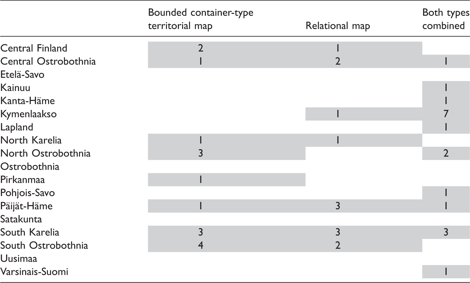
Only four of the analyzed plans (South Savo, Ostrobothnia, Satakunta and Uusimaa) do not include maps. While the educational background of the planners may explain the absence of maps to some degree (none of these planners were geographers), the tendency to omit maps is more specifically related to the changes that have occurred in the strategic planning of the Regional Councils since the turn of the millennium. Instead of the former comprehensive, literally ‘thick’ and wide plans, in most cases new plans are relatively brief. They also often contain carefully chosen, stylish photographs depicting landscapes, events and urban and rural areas of the regions that serve as important elements in regional image and identity-building. Six plans embrace both container-type and relational maps. The former typically depict either the internal regional structure of the region or the administrative division of the region into municipalities. The latter demonstrate visually how the region in question ‘leaks’ into surrounding spaces, or locate the region as part of wider national or supranational spaces, typically within the wider ‘space of flows’. Our first example, depicting the situation of Southern Ostrobothnia (Figure 1), displays the tendency to locate the region within a wider European space and the use of soft regions, fuzzy borders, and corridors in this positioning (cf. Harrison and Growe, 2014a).
Southern-Ostrobothnia and Bothnian Corridor in the European context. The map shows the relational location of the ‘Bothnian corridor’ in the wider network of Northern European connections (South-Ostrobothnia, 2010: 19).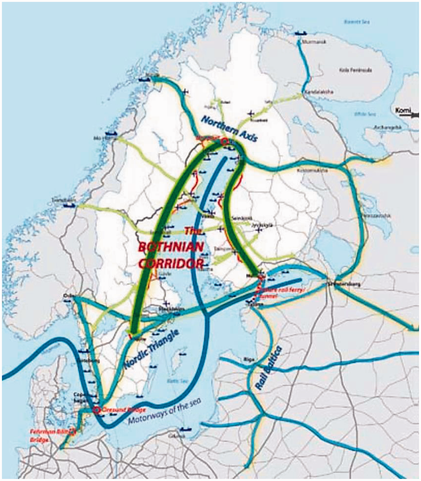
In general, maps have an important role in making planning spaces visible through ‘framing’ them. As Wood (1992: 10) has noted, “Maps link the territory with what comes with it”. The basic structure of the regional plans is similar in most cases, since the major tasks of the Councils are dictated by national legislation on land-use and regional development. On the other hand, however, the plans also characteristically concentrate on the respective ‘internal affairs’ of the region in question. This can be based on various rationalizations that are related to the “institutionalization process” of each region (Paasi, 2009, 2010). In some cases the distinctions made draw on culture, history, stereotypes, future expectations, or regional identity. It seems that more often than not the region in the plans is merely a given spatial setting for social action, a territorial framework where things (and planning processes) occur rather than something that is involved in directing the process through the organization of social relations, for example.
Regions are not regarded as strictly bounded units however (even if the interviewees often perceive that such boundedness is present, in very restrictive ways, in planning practices that extend outside of the regions): the maps used in the plans effectively accentuated the relational qualities of the regions, more precisely their connections to other regions, and often contained soft regions with fuzzy borders, i.e. diverging development zones that seem to be popular in these plans (cf. Haughton et al., 2010). Relational spatial representations can be seen not only as reflecting the emergence of new, soft forms of governance, but also as a means to depoliticize the spatial politics of strategy-making, as “a means to camouflage contested spatial politics” (Olesen and Richardson, 2011: 361). Thus, relational approach can be conveniently utilized in efforts to build consensus around spatial strategies and planning, especially in situations where borders are contested: “So passions arise at latest when people start to think where the borders should go. And all kinds of ‘mapping exercises’ are extremely explosive. So such discussion is very meaningful and it is sensitive. Very sensitive.”
Our second cartographic example concerns the Northern Ostrobothnia region. Its regional plan provides an example of a map in which the traditional territorial representation is paralleled by an overlapping flexible, relational space that expands and stretches across regional and even national borders to Sweden and Russia in the form of development zones, connections, and flows. It thus represents a new networked regional imagery, with a highly relational understanding of space (Figure 2). Maps like this underline well the increasingly complex configurations of regions that are utilized in planning, and illustrate that planners are expected to think simultaneously both relationally and territorially.
Strategic vision of the spatial structure of Northern Ostrobothnia in year 2030 showing the network of development zones (kehittämisvyöhykkeet) and ‘soft spaces’ of tourism development with fuzzy boundaries (Matkailualueet-ja keskukset) (Source: Northern Ostrobothnia, 2010: 28).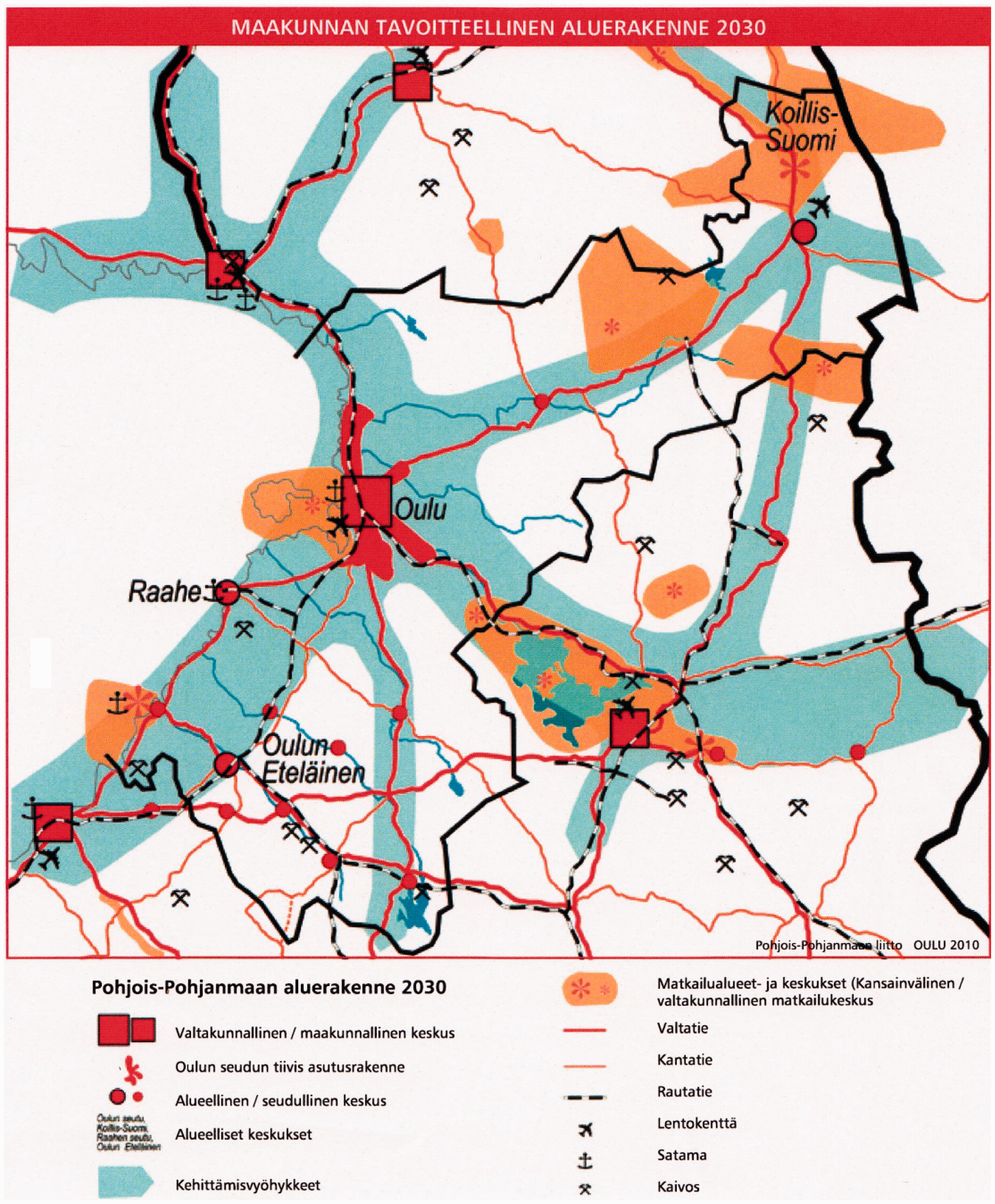
Planners at work: Planning practice and the territorial/relational world
In the next two sections we scrutinize how planners face borders in planning practice and how penumbral borders work. First we must emphasize that in some cases both the plans and planners accentuate the open/porous character of regions and their boundaries within wider networks of interactions, whereas in others the plans/planners display a more inwards-looking orientation, just as the two quotes at the beginning of this article show. Our observations are thus generally supportive of the recent arguments according to which it is unhelpful to make a sharp distinction between relational networked geographies and bounded regions and rigid notions of scale, as these elements are simultaneously relevant in planning, causing “messy” notions of space (Jessop et al., 2008; Morgan, 2007). Nevertheless, planners often feel frustrated by the fact that the strategic horizons of the plans are limited to their own regions. The planning practice is thus largely territorial and focuses on the region in question. Planners often accentuate—in line with the plans and their cartographic representations—the relational character of the contemporary world and their region largely because planning policies and concept are indeed mobile (cf. McCann and Ward, 2010; Prince, 2012), but at the same time they think that it is their professional obligation to create an image of an existing territorial community with a unique identity. The administrative territory sets a statutory frame for their work, and planners are at times irritated by the restrictive roles that territorial borders play in the planning process. “Yes, they (borders) are present, because Finland is divided into provinces, and Regional Councils have their tasks, based on legislation, so it is rather difficult to go on to plan with the neighbouring regions … there would immediately be a question like What are you doing here?” “Well, we are of course still in a situation that we make, you know, the plan for our own province with those borders that we have . … During this round we (different Regional Councils) have prepared our plans simultaneously, but this has not meant much more than asking routine comments and statements and discussions between colleagues like ‘How is this issue seen in your region’?” “The province is a cooperative network of regional actors which improves the competitiveness of enterprises, and the incomes, welfare and influence of citizens in South Savo. The aim of fulfilling the strategy is to support the success of the region.” (South Savo, 2009: 1) “Networks and interaction provide the means to achieve all other aims of the regional plan. At the same time they are also the key in the effort to reconcile the aims of various actors and provinces. Networks and interaction exist between human beings, themes and sectors, public actors, centers, population centers and villages, provinces; nationally and internationally.” (South-Ostrobothnia, 2010: 15)
Another side of the planning paradox is that in the context of governance ‘network talk’ often becomes expressed through borders and bounded wholes, even if network thinking in principle tends to downgrade their role (Eriksson, 2009: 226). This is based on the idea that governance aims at rendering coherent action possible (cf. Miller and Rose, 1990). Therefore, it is a condition of coherent thinking and action in governance that there exists some consistent ‘whole’. Eriksson (2009: 229) argues that as soon as an idea of the existence of a network achieves a ‘technical meaning’, it is transformed into a useful political tool, a ‘whole’, and it begins to generate a border between the inside and outside (cf. Zimmerbauer, 2014). Similarly, Allen and Cochrane (2007: 1162) note, “Rightly or wrongly … political institutions lend themselves to the language of territory, fixity and boundaries … territorial focus has remained much the same, despite a more flexible spatial vocabulary that speaks about regionalization and the re-scaling of the state”. Planners recognized the territorial focus well, yet they are also aware of the power of language in form of new, often ‘imported’ keywords: “… we have to remember that we are operating in rather small circles in Finland when regional development matters are concerned … when one keyword breaks through, it is extremely strong. It becomes a mantra that is repeated, and any challenge to it, or let’s say, translation of it into Finnish, will be doomed to failure in these circles.” “Yes, we always have this boom of fashionable terms in Finland. At one time it was innovation, then networking, then globalization. These words were learned and used in all possible connections.” “… competitiveness is a word that I have started to avoid—the second one after ‘excellence’. It involves a certain narrowness . … I have not used the word competitiveness at all in our new plan.”
Beyond the fuzzy maps and relationality: Penumbral borders in planning practices
For many planners borders are largely given entities that accentuate the limits of power embedded in the planning process and how this power is contextualized into a specific administrative unit. The interviews demonstrate how the planning process simultaneously pulls together actions and processes occurring at and across various scales and contexts, hence displaying how borders and networks closely resonate in planning practice (cf. Davoudi, 2009; Healey and Upton, 2010). “Well, of course in the administrative sense we are forced to think about (regions) very much as bounded. But, as I referred earlier to the matters related to regional structure, … and here to ‘dimensions’ that cross borders and similarly to logistic issues and problems related to accessibility. And as you mentioned networks, so networks cannot be restricted by any administrative border. But because of some bureaucratic dictates—I take the question of structural funds as an example of issues where we have to stay within certain ‘formulas.’”
The idea of a penumbral border refers to the fact that borders are deeply multilayered (cf. Zimmerbauer, 2011), consisting of administrative, juridical, social, cultural, economic, identity, linguistic, and possibly other layers, and while some layer might be highly permeable, other layer(s) can simultaneously make borders high and hard. Thus, instead of speaking of fuzziness or porosity in general, we think that the notion ‘penumbral border’ better captures the multilayered roles of borders in planning, as it underlines that the various layers of borders have an effect only when “the light is cast from a certain angle”, i.e. in certain practices and discourses. This concept also underscores the temporal aspect of the issue (cf. Walsh et al., 2012): a penumbral border may be visible and meaningful (that is, relevant) only occasionally, for instance when funding is applied for or when the regional plans (with supporting cartographic representations) are being made. Thus, penumbral borders are highly selective in terms of flows and closures, and they are activated in both context- and time-contingent junctures. The notion hence does not at all imply that these borders would be phantasmal, vacuous, or illusory.
As Haughton et al. (2010: 52) remind, formal planning mechanisms, with their legal responsibilities, are above all rooted in statutory spaces, the ‘hard spaces’ of governmental activity. As we saw above, the idea of soft space seems to resonate with regions that cross statutory regional borders, for instance enterprise or development zones, potential future ‘growth areas’ and ‘internal’ development initiatives that are not coterminous with the borders of old, established standard regions (p. 52). Soft space might thus be a relevant and appropriate concept in describing and representing new, non-standard regions that do not follow any established administrative boundaries, but is perhaps not so useful in the case of fully institutionalized territories or planning regions that have an uncontested, statutory position in regional structures. While new, non-standard (Deas and Lord, 2006), soft planning spaces may have fuzzy borders, the borders of old statutory regions are typically not fuzzy, although they can be functionally porous in the wider relational space.
Thus, a distinction between old and new regions (Paasi, 2009) also becomes important for our study. Consequently, we argue that in the case of Finnish provinces the notion of penumbral border becomes salient due to one fundamental fact: these regions are old, well institutionalized and have relatively uncontested delineations. Implementing the new planning agenda with its ‘fuzzy borders’ to old established regions with histories decades, even hundreds of years long, means that statutory hard spaces are being ‘softened’ in planning. This occurs through imagining sub-regional and cross-border ‘soft-spaces’ (and putting them on maps) (see Figure 2). This process illuminates the penumbral borders even more clearly in planning practices, as besides the formal administrative layer, other layers of borders (culture, identity, economy, etc.) can be relevant, too, and ‘haunt’ the newly-presented soft spaces from within. This relative softening of hard spaces must be highlighted because much of the recent literature on soft spaces and fuzzy borders has focused on how newly conceived soft spaces tend to become hardened (cf. Metzger and Schmitt, 2012).
However, penumbral borders are not merely lurking under the porous ones in old regions. They are also actively and consciously produced in (re)territorialization practices. First, they exist because they are manifestations of power that derives from agency that is not one-dimensionally located in certain powerhouses like planning offices but is embedded in a complex assemblage of actors, interactions, interests, negotiations, struggles, and events that occur through networks. As Cochrane and Ward (2012) succinctly note, the administrative power embedded in the increasingly networked forms of governance characteristically includes a territorial element. Moreover, such penumbral borders may also have a variegated effect on how different factions of public and private sector actors, politicians, and coalitions operate within bounded spaces and across borders. Yet, as Jones (2009: 494) suggests, “when performing their practical politics, agents imagine and identify a discrete, bounded space characterized by a shared understanding of the opportunities or problems that are motivating the very nature of political action.”
Second, penumbral borders also matter in the context of regional identity, one of the keywords in contemporary regional planning (Hague, 2005, Paasi, 2013). A certain boundedness has namely been, by tradition, associated with the idea of regional identity, which echoes the common view that identities and penumbral borders are closely related to each other. Interviewer: Do the borders of the provinces matter today? You mentioned earlier that in this province certain ‘episodes’ have served to highlight borders? Planner: Yes, they certainly have, since regional identity is somewhat bounded.
Third, marketing and image-building in particular often utilize identity-discourses and tend to lean on the idea of regions as bounded spaces. This is emphasized in regional promotion which is normally more outwards-oriented than identity-discourses (Paasi, 2013; Zimmerbauer, 2014). Although the inwards-looking idea of a fixed and bounded identity has been challenged by relational thinking (Allen et al., 1998; Paasi, 2013), regional promotion tends to mobilize the ideas of relatively fixed spatial entities and identities through territorial representations. As one planner explained: “Yes, it is said that they (borders) are not important, and when we go to our southern border between municipalities X and Y its such that X-Y forms an economic region and they have many common things for instance in education … so in this context borders seem to matter little … . But when we think about the marketing of the province … and come to the identity of the province, that it should be marketed, municipality Y does not at all feel that it belongs to this region and of course is not part of it.” “Entrepreneurship, or the largest part of it, has operated across borders since the beginning of the 19th century especially during the 1980s–1990s … foreigners have increasingly become the owners of the entrepreneurship … . And then this, you know this research and scientific world, it is increasingly tied with international research programs and the EU’s finance … . So, … it is difficult to be here inside of our own borders, to barricade ourselves in.”
Discussion
Many scholars have shown that the conceptions of space used in strategic spatial planning have developed by following a certain logic that displays, perhaps with some delay, the evolution of wider scientific thinking, certain conceptual frameworks, and the development of cartographic techniques (Davoudi and Strange, 2009; Haughton et al., 2010; cf. McCann and Ward, 2011). These elements are embedded in the wider circuits of knowledge and techniques that constitute the transnational flows where planning ideas and practices travel (Healey 2013). Much of strategic planning occurs today in the framework of relational thinking, which can be seen in changes of planning vocabularies and concepts, as well as in concrete plans and their cartographic representations. Regions are currently seen as social constructs that have, especially in relational thinking, relatively porous or even fuzzy borders.
However, our empirical analysis based on an analysis of regional plans and the interviews of planners demonstrates that territorial dimensions and networks exist simultaneously in planning practices, which causes a degree of inconsistency and friction in the thinking and work of planners. We have illustrated that despite the current emphasis on networks, flows and connectivity, planning occurs in many respects in a ‘regional world’ that is perpetually characterized by a sort of boundedness and a certain degree of fixity (cf. Harrison and Growe, 2014a; Jones and Paasi, 2013). Our analysis has revealed that while borders may be porous or even fuzzy in certain cartographic representations as well as in planning rhetoric, they are often less porous in planning practice that is embedded in statutory contexts.
We have been particularly interested in borders which have often been taken for granted in planning debates (but see Davoudi, 2009; Healey, 2007). Both the analyses of planning documents and planners’ interviews demonstrate that borders are seen as rather ambiguous in the context of regional planning. They are sometimes very clear-cut, yet context bound, and they typically manifest in certain practices but not in all: the context and practice clearly make a difference. Respectively, we have suggested that contemporary borders in planning are not either territorial lines or porous (or ‘fuzzy’) relational ones. We have proposed the concept of ‘penumbral border’ that makes this complexity more comprehensible. Respectively, this notion suggests that borders can manifest themselves in some practices and discourses and respectively be made illuminated by observing these practices and discourses in the planning process in the context of some specific activities, discourses, and temporalities. Thus this concept does not by any means suggest that a penumbral border would be delusory, chimerical or purely imagined, but rather provides a more nuanced viewpoint for understanding the meanings of borders in a situation where planning processes, contexts, and vocabularies are increasingly complex.
Our empirical observations show that it is not always easy to think and act territorially and relationally at the same time in planning practice, which is why there is occasionally a mismatch between practice and discourse/language/vocabulary, and between plans and planners. It should also be acknowledged that despite the new planning lexis accentuating fluidity, fuzziness, and connectivity, neither the networks of governance nor the planning itself are able to escape the penumbra of the politico-administrative units. Thus, spatial planning invariably entails some ‘thick’ ontology of bounded regions which stems from formal organization, hierarchy, and spatial identities (Axford, 2006: 164). Yet territories often result from and are maintained by complex networks. Relational and territorial should therefore be viewed not as entirely commensurable categories, but as sometimes, but not always, mutual and intertwining, contextual, dynamic, and contested dimensions in planning practices.
Footnotes
Acknowledgments
The authors are grateful to the anonymous reviewers and editors for their very useful comments. Usual disclaimers apply.
Funding
The authors wish to thank the Academy of Finland’s RELATE CoE (Project grant number: 272168) for financial support.