
Abstract

Maps bring power, and yet the people on the map have rarely had any say in how they are drawn.
It all started with a visit in the mid-90s from then-president Cheddi Jagan who – perhaps unintentionally – set them the challenge to take map-making into their own hands. Conversation soon turned to the Wapichan’s longstanding claim to 2.6 million hectares of land, which has been ongoing since before Guyana gained independence from Britain in 1966. The president put forward an ultimatum: the Wapichan needed to show how they use their land and why they demanded its control.
Guyana has long been a hotbed for territorial disputes. Even its international borders remain contested. Suriname, the former Dutch colony to the east, claims a southern chunk. Venezuela, to the west, wants an even larger portion, refusing to allow any border crossing as a result and leaving Guyana even more isolated from the rest of the world. “It must be a pretty claustrophobic experience being a map nerd in Guyana,” wrote self-confessed map nerd Frank Jacobs in a New York Times piece about centuries of “cartographic aggression” in the region.
Internally, the fights are even fiercer. The country is 80 per cent covered in virgin rainforest; the little development it has hugs tightly to the coast and its muddy-brown stretch of Caribbean (so coloured for its proximity to the sediment-churning mouth of the Amazon). Guyana is a country the size of England with a population less than 800,000, and it is ripe for prospecting. Gold and diamonds are found here, as are bauxite, uranium and high-quality wood. Many concessions have government approval, but a large proportion of the mining and logging activity is illegal, often involving clandestine operations in the dead of night. Repercussions felt by the local community include deforestation, pollution – including mercury in the water, a byproduct from gold panning – and increased reports of rape, prostitution and human trafficking.
The Wapichan took President Jagan’s challenge seriously. They went to the capital, Georgetown, to seek training and funding from the Amerindian Peoples’ Association [APA], a national NGO representing the nine indigenous peoples of Guyana. The then chief, Kokoi, told Index that the aim was to build on an initial report lodged with the Amerindian Lands Commission in the 1960s. “Back then most of our chiefs did not know to read and write, so when I became chief, I kept reminding our peoples of the need to continue to pursue our land’s legal recognition,” he says.
Repercussions felt by the local community include deforestation and pollution – including mercury in the water, a byproduct from gold panning
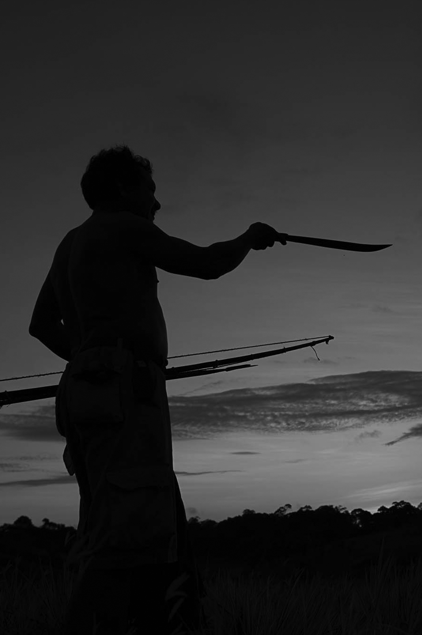
ABOVE: A Wapichan man watches the sunrise on the top of Savannah mountain, south-west Guyana
Credit: Gregor MacLennan/Digital Democracy
The on-the-ground mapping took until 2000 to get under way. Much of it involved collecting GPS points, with the Wapichan setting out on expeditions by bike, motorbike or on foot – with some trips taking several days. Simple pen and paper played its role, too, as they called on members of the communities to join in, asking them to share picture of local sites that were important to them. Crucially, the communities were the ones deciding what was worthy of mapping. They mapped sacred sites, burial grounds, hunting areas, wildlife zones, rock carvings – and all were referenced in the Wapichan language.
“Amerindian land use is invisible to many,” says Tom Griffiths, who works for the Forest Peoples Programme, an NGO that has provided assistance with the project. “People just don’t see hunting, gathering and fishing as active use of the land. They only see it if you build a house or a bridge, or dig a hole.” The Wapichan’s map is concerned less with showing the way from A to B than with showing traditional occupation, negotiating inter-community politics and tracking illegal mining. “Baseline maps, based on surveys conducted decades ago by the British, with their 1:50,000 ratio, show limited detail and contain many errors,” says Griffiths. “This led to confusion in official land use plans. Community boundaries are also misrepresented; and arguments over title boundaries abound.”
The Wapichan’s map took more than 10 years to produce and was compiled from over 30,000 GPS points. These points were then cross-referenced using satellite images to make sure everything lined up in the right place. In 2013, the US-based organisation Digital Democracy joined with the Forest Peoples Programme to offer technical support after receiving a grant from the Knight Foundation to fund a new remote-access project. “[Digital mapping tools] aren’t made with these end-users in mind,” says Digital Democracy’s director and founder Emily Jacobi. “These are people living in remote parts of the jungle, accessing the internet on their mobiles, with no broadband and very different needs. Which Silicon Valley investors are focusing on making apps for people with limited literacy and no bank accounts?”
This is where they step in to the bridge the gap. Digital Democracy has been working with the Wapichan to develop new mapping tools that can be used offline to suit their specific needs. As a starting point, they looked to OpenStreetMap, an open-source program that was used during the Haitian earthquake in 2010. During the crisis, the lack of decent maps of the country was inhibiting the response teams, so volunteers began tracing satellite images to create workable plans. Even when street signs were gone, aid workers and rescuers could still follow the contours of the map.
Since then, an in-browser tool called iD Editor has been devised to make OpenStreetMap easier to use, but it can only be used online, which, when traversing the depths of Guyana, is impossible. Digital Democracy has been working on an offline version that it is currently trialling. “The added bonus of an offline tool is data can be uploaded later. The community can choose when to share their information, and who to share it with, be it a legal group, an advocacy group or the government,” says Jacobi. She believes it will be of benefit to other indigenous populations around the world, including Native American reservations in the United States.
The Wapichan are currently receiving funding from the UK’s Department for International Development and Size of Wales, a Welsh initiative to protect an area of rainforest as big as the country. They have formed a local NGO, too, called the South Central People’s Development Association. These have helped fund an office – a small building on the open savannah, surrounded by mango trees – with solar panels, a satellite internet connection, three laptops and a printer. Jacobi says the introduction of technology needn’t be seen as a threat to tradition. “So many [indigenous] people have been dealt this false dichotomy – where your choices are to assimilate so you don’t get left behind, or be completely isolated,” she says.
The idea is for the map to be dynamic and evolving, rather than static. The next stage involves monitoring all activity on the land and using the information in dialogue with national government agencies and to denounce deforestation and human rights abuses on global online platforms. Ron James, Kokoi’s son and the community’s mapping technician, says he is looking forward to the next phase. “The monitoring team just came back with loads of information, in terms of how many illegal crossings are taking place from Brazilian ranchers coming in to rustle our cows and hunt in our land,” he says. “We can upload their photos and information via the few internet points we have and, in a matter of days, our people can see, our leaders can see. Then we can make decisions, we can take it to the relevant authorities.”
Which Silicon Valley investors are focusing on making apps for people with limited literacy and no bank accounts?
Of course, not everything important to the Wapichan makes the map. The areas rich in gold and diamonds, which the Wapichan know well, are not marked. “No map is ever neutral,” says Peter Barber, head of map collections at the British Library and author of Magnificent Maps: Power, Propaganda and Art. “All are bound by conventions. All, for example, face north. Everything you put on it is hostage to fortune.”
Barber also points out that it is a misconception to think that indigenous people have never been a part of the mapping process. Their knowledge has often been drawn on and many joined Western cartography expeditions as guides. However, their needs would not have been put first. “The West would get out of it what they wanted, without understanding the underlying values,” says Barber. He references a chunk of beech bark, held in the British Library, which shows a hand-drawn route map drawn by indigenous people in Canada in the mid-1800s. It was collected by the British military and written beside it was a note, reminding young officers “how small an effort is needed to acquire that most useful art of military sketching, since even savages can make an intelligible plan”.
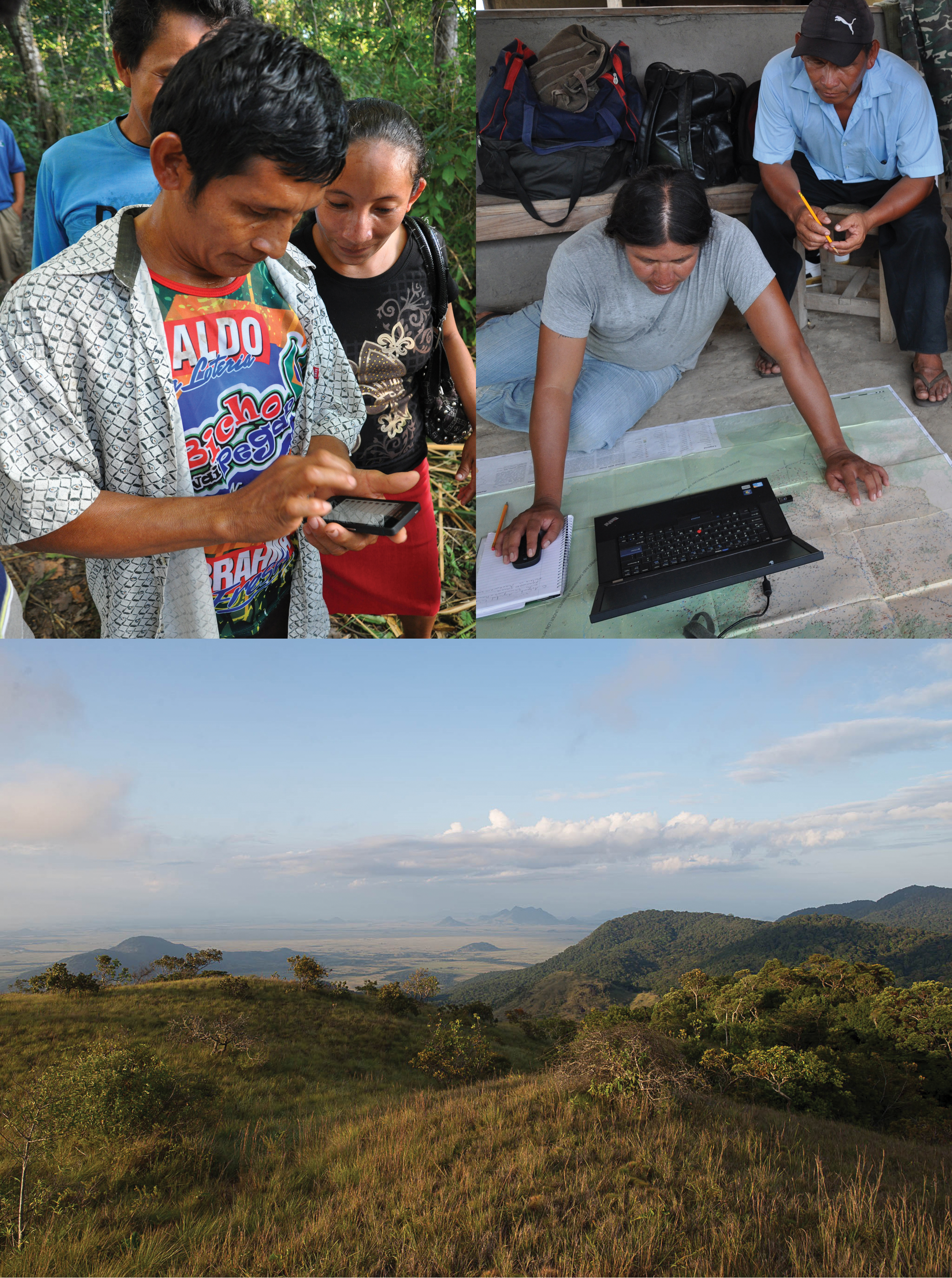
TOP LEFT: The Wapichan mapping project in progress
Credit: Tom Griffiths/Forest People Programme
TOP RIGHT: The Wapichan mapping project in progress
Credit: Tom Griffiths/Forest People Programme
BOTTOM: Rupununi savannah from the Kanuku mountains
Credit: Gregor MacLennan/Digital Democracy
Historically, the best-known example of an indigenous mapmaker is Tupaia, a Ra’aitean priest whom James Cook met in Tahiti. His charts were used by Cook to navigate Polynesia in the late 1700s and were incorporated (after being modified to meet Western mapping requirements) into his own maps, which formulated standard Western views of the region. Recent research has suggested that a similar set of circumstances occurred in around 1500, when the Portuguese reached the East Indies and shortly after, thanks to local navigators, found themselves able to chart the coast of Indo-China.
It’s a leap backwards for indigenous people to have no say in official maps now, and a situation the Wapichan have been trying to correct – and not without problems. What happened to President Jagan, who first laid down the idea of proving the territory is in use? “He died,” says Kokoi. “Now it’s getting much more difficult. We are seen as extremists, and against development. My life has been threatened more than once.” But James says there are shoots of optimism, too: “Villages have presented detailed maps of their proposed land extensions to the government, complete with river and place names, and the government is now taking notice. The monitoring aspect of the project is very exciting and I can only hope that our leaders make maximum use of it.”
Guyana once claimed it would be the world’s first truly green economy. There is still a long way to go and, 50 years since first lodging their claim, the Wapichan’s work goes on. “Most people don’t understand why land is important to us,” says Kokoi. “We do not see the land as a commercial commodity, which can be sold for money. Our water sources are important for the entire world, but extractive activities are and will continue to destroy in the name of money and economic development. The lands are our supermarket, our university, our science labs, our libraries, our hospital, our recreational grounds, and, most importantly, they have spiritual value.”
We are seen as extremists, and against development. My life has been threatened more than once