
Abstract
Protected areas are seen as one of the primary instruments to halt biodiversity loss, but it is not always clear if a protected status designation contributes to the preservation of endangered species and ecosystems. One way to address the issue is through monitoring, the regular counting and measuring of ‘nature’. However, more than merely representing nature in a protected area, monitoring enacts nature. In this article, I explore a specific protected area by way of an ethnography of different monitoring programs in Neusiedler See–Seewinkel National Park in Austria. Characterized as a quintessentially naturecultural landscape, the formal boundaries of the national park only partially match when and where monitoring is done. To make sense of the differences, I trace practices of monitoring of the soda lake ecosystem, vegetation, and geese as multispecies activities, shaped by both human and non-human performances in and of space and time. I thereby suggest considering protected area monitoring as a distinct knowledge practice that contributes to shaping protected areas as lived conservation infrastructures.
Introduction
As an instrument for addressing ongoing species extinction and biodiversity decline, the idea of putting a certain percentage of the Earth’s surface under protection is highly influential. It is seen in such recent political agreements and strategies as the 2022 Kunming-Montreal Global Biodiversity Framework, the 2020 European Union (EU) Biodiversity Strategy for 2030, and the 2024 EU Nature Restoration Law. Particularly with reference to the Global Biodiversity Framework, the 30x30 target would place 30% of the Earth’s surface under protection by 2030; this has become a guiding light for conservation efforts (Zeng et al., 2022). So-called protected areas include a wide array of spaces assigned for biodiversity conservation under divergent criteria and regulatory formats. Existing protected spaces are considered building blocks already contributing to the 30% aim, and are further stepping stones to reach that aim.
In spite of their currency, the idea of protected areas is contested. At one level, the implication that conservation excludes other land uses has raised concern about such sustainability goals as food security (Arneth et al., 2023) and the continuation of colonial legacies of forced displacement (Blanc, 2022). Even where the idea of protected areas is well-established, observers have flagged two paradoxes: On the one hand, commitments to protection on paper do not necessarily translate into protection in practice. For example, the idea of protecting 30% of the planetary surface raises questions about which 30% should be dedicated to conservation and about how effective conservation measures should be implemented. Often, some analysts argue, protected areas are designed and mapped out opportunistically, without sufficient consideration of their conservation aims (Mouillot et al., 2024). On the other hand, designation, implementation and management of protected areas do not automatically result in thriving and resilient species and ecosystems, not least due to a misalignments with the habitats and range of species considered of conservation interest (Cole & Johnson, 2025; Hoffmann et al., 2018). Even though protected areas are considered a ‘backbone of global conservation efforts’ (Li et al., 2024, p. 1), their contributions to halting biodiversity decline are surrounded by uncertainty.
The uncertainty is in part due to the tension between the framing of biodiversity decline as a global problem and the necessarily situated and specific character of any species, habitat, or ecosystem (Devictor & Bensaude Vincent, 2016). Hence, while many publications questioning the effectiveness of protected areas for conservation are based on large datasets and machine learning approaches (Li et al., 2024; Mouillot et al., 2024), assessing conservation success simultaneously requires consideration of conservation activities in individual protected areas. In other words, ‘[if] biodiversity is the conservation target, protected area planning and management will have to measure biodiversity’ (Hoffmann, 2022, p. 337). Measurement, which in the context of conservation refers predominantly to (regularly) counting or ‘monitoring’ species and ecosystems (Langhammer et al., 2024), is thereby presented to be critical for identifying the need for and effects of conservation measures (Casetta et al., 2019). In that light, both protected areas in general and specific such areas may be understood as infrastructures for conservation and knowledge infrastructures, due to the ways their legal, organizational and material form facilitate knowledge production and management of endangered species and ecosystems.
Work in science and technology studies (STS) and environmental humanities on species extinction and conservation has emphasized the importance of considering specific, situated cases and stories (Bird Rose et al., 2017; Boonman-Berson & Turnhout, 2013; Van Dooren, 2022). In this article I focus on scientific field practices in the context of various monitoring programs in a single protected area (see Lorimer, 2008). I present ethnographic observations to trace how these practices jointly constitute a protected area as both a conservation and a knowledge infrastructure. I further understand this infrastructure as a space when and where ‘species meet’ (Haraway, 2008; Hinchliffe, 2010) to do justice to the more-than-human constitution of this infrastructure. I thereby aim to show how a protected area forms a naturecultural, multispecies contact zone both as a category for ordering conservation and as a particular place.
I develop this argument on the basis of an ethnography of monitoring practices in Neusiedler See–Seewinkel National Park in the east of Austria. A tourist guide on all six of the country’s national parks characterized ‘Austria’s steppe national park’ as ‘a paradise for birds and birdwatchers’ (Platzgummer, 2013, p. 1)—all translations from the German are mine. While the wide variety of birds that appear in the area are surely key to the national park’s public profile, its variety of ecosystems more broadly signals its conservation value. Moreover, another distinctive characteristic of the national park and the surrounding region is how the landscape ‘has been shaped by centuries of human use’ (Platzgummer, 2013, p. 20). As such, a key feature of conservation in the region is how to respond to the paradoxical influences of agricultural activities, which both contribute to and threaten species and ecosystems in a manner typical of many protected areas (Zavattoni et al., 2025). This particular field of tension is reflected in the spatial and temporal formation of species and ecosystem monitoring I describe in this article.
To set the stage, I discuss how national parks, as specific naturecultural entities, enact particular, measurable natures through both regulation and monitoring. I then consider the latter as a form of infrastructuring to make sense of how a national park is enacted through counting and measurement practices. However, I consider these practices to be multispecies practices that negotiate multiple spatialities and temporalities. By attending to particular instances of monitoring practices, I will show how national park monitoring is a multispecies activity. I substantiate this idea by presenting ethnographies of soda lake, vegetation and goose monitoring practices. Focusing on the multiple forms of space and time that intersect in these practices, I conclude by suggesting lessons that can be drawn from such an ethnography for both STS and the idea of area-based conservation.
Multispecies Spatiotemporal Enactments of a Protected Area
Conservation infrastructures are circumscribed by laws, regulations, classifications and other means of administrative ordering. As such, protected areas are anthropocentric in their aim of preserving non-human forms of life. Protected areas exist in a wide variety of forms with distinct purposes; they may be designated on the basis of nationally or regionally specific criteria, as well as internationally authoritative categories assigned by such entities as UNESCO and the International Union for the Conservation of Nature (IUCN). The latter organization distinguishes six categories of protected areas that allow an increasing degree of human intervention. Among these categories, areas in category II are commonly labeled national parks, although this designation has different meanings around the world, not all of which fit the IUCN criteria (Dudley, 2008). Neusiedler See–Seewinkel National Park is recognized as a category II area, which for IUCN means that its primary objective is ‘[to] protect natural biodiversity along with its underlying ecological structure and supporting environmental processes’, while also ‘promot[ing] education and recreation’ (Dudley, 2008, p. 16). According to IUCN criteria, national parks should be of sufficient size to maintain distinct natural regions, species diversity and ecological processes, but at the same time need to balance such conservation aims with (certain) human uses.
Various historians have proposed to understand national parks as primarily cultural achievements, that project visual rhetorics of power and identity onto landscapes (Hanisch, 2019; Patin, 2012). Furthermore, a collection of studies on the global circulation of the idea of national parks has illustrated how they are shaped by both ecological and political criteria, and affect relations between nature and culture in various ways. These studies suggest that national parks civilize nature as distinct from but related to culture, territorialize nature within specific, contained spaces, and categorize nature under specific management criteria and forms of (scientific) legibility (Gissibl et al., 2012). Historians thereby describe national parks as a specific institutionalization of the relation between nature and culture that attributes particular meanings to nature. This perspective thereby confirms how defining nature is ‘not merely an objective scientific exercise’, but a culturally informed practice that has taken various shapes historically (Keune et al., 2022, p. 25).
Different historical characterizations of the natural world have implied distinctive valuations of its importance. Notions ranging from wilderness (Cronon, 1995) to biodiversity (Takacs, 1996) thereby each imply distinct perceptions of human relations to nature, how nature can be known and how and by whom it should be cared for. As the most authoritative present (scientific) description of nature, the concept of biodiversity ‘sought to put numbers on the dramatic loss of species’ (Warde et al., 2018, p. 92). Defining nature predominantly in terms of numbers through biodiversity allows for particular forms of governance (Turnhout et al., 2014), including those that frame the importance of conservation in terms of biodiversity’s economic value calculated in the contested terms of ecosystem services (Borie & Hulme, 2015). Biodiversity thereby invites an approach to knowledge making and conservation governance that some authors have characterized as biopolitical, due to its focus on calculative techniques as a basis for governing nature (Lorimer, 2015; Youatt, 2015). As the quintessential measuring practice, monitoring in national parks is deeply implicated in the construction of this particular kind of nature.
Monitoring is a form of infrastructuring, in which human societies organize their relations to more-than-human lives in space and time (Blok et al., 2016). The notion of infrastructuring, brings ‘into view the activities, materialities and concepts through which an environment is performed in always situated and contested ways’ (p. 2). This includes conceptualizing the environment in terms of biodiversity, which entails particular practices of data generation and handling. Based on the various monitoring (and other) practices applied in a national park, nature takes on multiple forms.
If nature in a national park is multiple and formed through practices, then space and time are not singular entities. In this vein, Hinchliffe (2007, p. 165) has suggested, that ‘spaces for nature’ are ‘matters to come, things to be made’. Thinking of spaces, including the spaces of protected conservation areas, in terms of practice, Whatmore (2002) stresses the wide range of practices that include regulation, legal classification, scientific knowledge-making, and more.
A national park is thus practiced in multiple, overlapping, but not synchronous forms, enacted through multiple temporalities or ‘timescapes’ (Adam, 1998). According to Adam (1998, p. 11), timescapes ‘emphasize their rhythmicities, their timings and tempos, their changes and contingencies’, thereby providing a perspective that ‘stresses the temporal features of living’, thus forming ‘the embodiment of practiced approaches to time’. In the context of the temporality of the Anthropocene, Bensaude-Vincent (2022) uses the idea of timescapes to challenge singular, linear framings of time, which reduce its complex, situated character to a homogeneous global narrative. She thereby shows how applying the notion of timescapes to contemporary environmental issues can show the complex, intersecting, and possibly conflicting temporalities of different forms of life.
Conservation often treats protected areas as laboratories in which nature can be controlled, managed and framed in the form of measurable populations, or ‘conservation as composition’ (Lorimer, 2015). Lorimer characterizes this kind of conservation as reactive, aiming to maintain an equilibrium of questionable viability in a changing world. While there is merit to this critique, focusing on the locally and temporally specific practices of national park monitoring—which on the surface appears to be the essence of doing conservation in terms of enclosed abstractions of nature—can suggest an alternative reading of conservation (see Aisher & Damodaran, 2016). Research objects in ecological field research cannot fully be controlled (Lorimer, 2008); however, rather than seeing this as a problem, I suggest that researchers involved in national park monitoring see it as a possibility to engage with non-humans in research and conservation.
Monitoring in a national park consists in mundane practices through which species and ecosystems are made known and how they thereby make a formally designated national park into a lived reality (Scherzer, 2025): a naturecultural space, both in terms of organization and in terms of the landscape itself. This perspective builds on work that has emphasized the inseparable entanglements and relationality of all species, humans included (Haraway, 2016; Ingold, 2013; Tsing, 2012). Attending to the practices of enacting a national park from this multispecies perspective requires an attentiveness to more-than-human lives (Van Dooren, 2018; Van Dooren et al., 2016). A national park is made through multispecies relations, for which monitoring, as a way of delineating and knowing the park, is particularly salient. Central to this multispecies enactment of the national park are the multiple, intersecting spatialities and temporalities of monitoring practices, park management, and the interactions of non-human species with their environments (Bull et al., 2018).
Multispecies Assemblage Ethnography of Multiple Monitoring Practices
The monitoring practices I observed in Neusiedler See–Seewinkel National Park include a variety of independent yet intersecting efforts, most of which are focused on specific species, taxa or ecosystems. There is no single, integrated monitoring program for the national park, nor are the various existing programs aligned. There is a research department within the park’s administration that coordinates monitoring programs, but does only a small section of the actual research. In my ethnographic research on monitoring, I therefore considered organizational aspects of the selection of programs I was able to observe, in addition to attending to routines and materialities of measurement. Across various monitoring programs I pursued an approach I characterize as multispecies assemblage ethnography.
I draw the idea of assemblage ethnography from Wahlberg’s (2022) approach to studying complex contemporary sociotechnical practices that operate across sites and scales. In the context of national park monitoring, the idea of assemblage implies understanding how a set of practices ties together space(s), species, regulations, and criteria. I approached monitoring as an assemblage of practices and forms of life across multiple spatiotemporal sites and scales. As a result, the national park and monitoring practices within it are always multiple.
As much as possible, I take the active participation of non-human life forms in monitoring practices seriously, while acknowledging the limitations of fully accounting for them (Bell et al., 2018). I therefore find multispecies ethnography useful for the sensitivity or ‘attentiveness’ it cultivates towards non-human forms of life (Van Dooren et al., 2016). Multispecies ethnography attends to ‘studying contact zones where lines separating nature from culture have broken down’ (Kirksey & Helmreich, 2010, p. 546). Species and ecosystem monitoring in a national park form one such contact zone, where we can observe the interactions of humans and non-humans (Van Dooren & Rose, 2016). Multispecies ethnography allows insight into how researchers understand the non-human world, how non-humans perform a protected area (or not) and thereby also shape research practices, and how these practices are assembled into multiple, intersecting, spatial and temporal scales.
This multispecies assemblage ethnography is based on fieldwork that consisted of multiple one- or two-day visits on which I joined researchers in the field for data collection, as well as a handful of contextualizing interviews. My observations betray the conflicting temporalities of various monitoring programs and my own academic work. Periods of fieldwork have been scattered across two years. Many monitoring programs involve only a few field days per year and in many cases I could not align them with my other professional responsibilities. Moreover, monitoring plans were often changed on short notice, whereas my presence usually required some planning ahead. I made a few trips to the region when inclement weather (rain and fog, specifically) made monitoring impossible—although such experiences did provide insight into how precarious work in the field can be. Overall, I had the opportunity to observe five monitoring programs on at least two occasions, and two programs only once. Adding seven interviews that provided context provided insight into two further programs, and related monitoring to other activities and responsibilities of the national park. This fieldwork has generated a broad understanding of practices of monitoring ecosystems, flora and various species of fauna in the Neusiedler See–Seewinkel region.
After setting the stage by providing a broad sketch of the national park’s naturecultural geography and history, I present three distinct monitoring programs as examples. I focus on their temporal and spatial characteristics, both in terms of researchers’ work routines and the dynamics of species and ecosystems. I further present details of the sociomaterial infrastructures of knowledge production that involve, for example, both aspects of collaboration and organization, and use of particular tools and instruments. Finally, I attend to the kinds of data generated and how it is further processed and analyzed, providing a look into the status and challenges of conservation in the national park.
The first of my examples concerns one of the most highly valued, distinctive and threatened ecosystems within the region, known as soda lakes. Here I focus on the spatiotemporal configuration of the national park in relation to the surrounding region and researchers’ work routines. Next, I turn to vegetation monitoring, in this case looking at how grazing cattle affect the region’s flora; this provides insight into different temporal features of the national park, the region in which it is integrated, and individual habitats. Finally, I turn to the monitoring of birds, focusing on the monitoring of geese during winter. Here, monitoring is spatially and temporally positioned in a much wider environment, due to the high mobility of geese.
Situating Monitoring in Neusiedler See–Seewinkel National Park
Neusiedler See–Seewinkel National Park is located on the eastern edge of Austria, where it borders the ecologically similar but administratively separate Fertö-Hanság National Park in Hungary. It is one of six national parks in Austria, which a government document described as ‘the natural jewels of our country’ (Austrian Federal Ministry of Sustainability and Tourism, 2018, p. 6), serving the preservation of national heritage and identity as well as ‘help[ing] to increase the long-term survival chances of species and ecological communities [and] achieving national biodiversity targets’ (p. 7). A study of species coverage in Austria’s national parks confirms that, in spite of the limited spatial coverage (of roughly 3% of the country’s surface), national parks cover 70% of all flora and 90% of vertebrate fauna in the country, with the largest percentage of species unique to one national park occurring in Neusiedler See–Seewinkel (Zulka et al., 2022). Moreover, both the ministry’s strategy and the national park’s management plan (Nationalpark Neusiedler See-Seewinkel, 2021) emphasize the importance of research and monitoring as core objectives.
The national park is not only located at and across a geographic border. Part of the complexity in national park monitoring and management emerges from various other border crossings. For starters, the national park is subject to different but intersecting legal regimes. In Austria’s federal political system, nature conservation falls under the remit of the states (Kraemmer & Onz, 2018), which means the national park was established by a regional law. At the same time, as a member of the EU and signatory of several international agreements, the national park’s regulatory framework also includes Natura 2000 status, which is based on the EU habitat and bird directives, as well as the international Ramsar convention for the protection of wetlands. Several forms of legal protection, each with their own conservation criteria, thus are layered onto each other. These are part of what constitutes the national park in a formal, legal sense.
Furthermore, this particular park’s liminal status also results from framing the landscape as atypical for Austria, a country mostly known for its alpine regions (Hanisch, 2019; Schön, 1999). The broader Neusiedler See and Seewinkel region, by contrast, is flat, dry and often characterized as the westernmost edge of a steppe landscape extending to Central Asia. It is located at the intersection of alpine, steppe and mediterranean climatic zones, each of which leave traces in the region’s biological diversity (Fally & Fischer, 2021; Schön, 1999). Moreover, the landscape straddles the boundaries between nature and culture. The habitats now considered worth preserving have largely been shaped by centuries of hydrological works and extensive cattle farming creating a ‘secondary’ steppe (Berger & Fally, 1995; Kohler, 2024). However, more recent intensification of agriculture is seen as a threat to the most valued ecosystems, which are therefore seen as requiring continued intervention and management for conservation (Berger & Fally, 1995; Schön, 1999).
Formal protection of specific areas in the region are largely the outcome of serendipitous developments (Prickler, 2003). Initial preservation efforts for parts of what is now the national park date back to the 1920s and 1930s (Berger & Fally, 1995; Schön, 1999; Weikovics, 2021). With structural changes in agriculture away from cattle farming, species-rich common pastures rapidly disappeared, which motivated the World Wildlife Fund (WWF) to buy the last remaining pasture and put it under protection in the 1960s. Such intermittent expansion of protection stood in tension with the more rapid growth of other land uses for agriculture, residential developments and tourism. Readers well-versed in STS, however, will appreciate that plans to build a bridge across Neusiedler See provided a push for political concern over nature in the region (Prickler, 2003; Triebl, 2021). Yet efforts to establish a national park only bore fruit in 1992 when the regional national park law was adopted, one year after the establishment of the Hungarian equivalent.
At present, the national park includes the large, shallow, high-salinity lake Neusiedler See and several areas in the adjacent Seewinkel region (see Figure 1). Following IUCN criteria, the national park consists of one strictly protected ‘nature zone’ (Naturzone) and five ‘preservation zones’ (Bewahrungszone). The former consists of the southern part of the lake and its surrounding reed belt; the latter cover a variety of ecosystems including traditional common pastures, arid grasslands, the remnants of a bogland and the highly valued soda lakes (Sodalacken) characteristic of the region. The preservation zones consist of multiple smaller parcels, often described in the literature and in conversation with national park staff as a ‘rag rug’ (Fleckerlteppich). This is a result of the highly fragmented land ownership in the region, rooted in the particular historical system of inheritance (Prickler, 2003). To secure regional acceptance for the establishment of the national park, all of the parcels included in the protected area fall under voluntary leases that run for as long as the national park exists. The national park thus has lease agreements with over 1200 (mostly small) landowners, who receive compensation payments for lost income (Berger & Fally, 1995). As a result, the national park is scattered among mostly conventionally managed agricultural land (primarily vineyards), which, in the words of one staff member makes the national park somewhat ‘impalpable’ (ungreifbar).
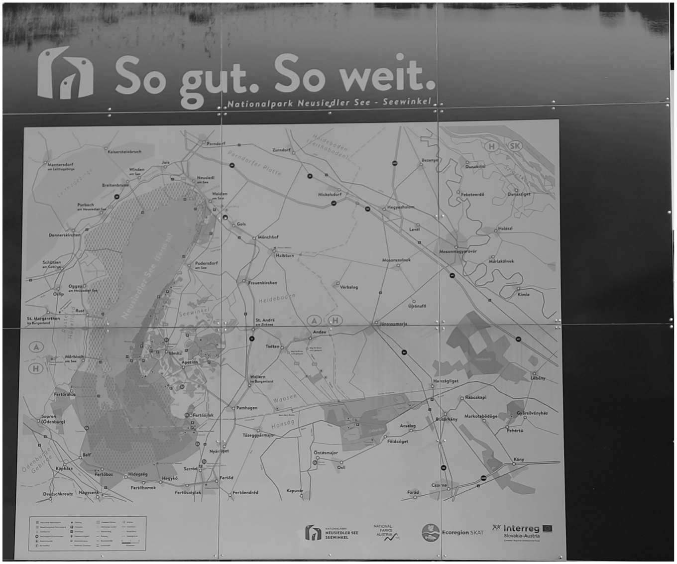
A map of Neusiedler See-Seewinkel and Fertö-Hansag national parks as exhibited outside the (Austrian) visitor center. Neusiedler See is on the left; the darker areas are nature zones, the slightly lighter ones preservation zones. Photo by the author.
Research and monitoring have been central elements of national park management from its establishment onwards (Herzig, 2021). The national park law of 1992 includes monitoring in both types of zones as an obligations of the national park society (its formal administrative form). The current management plan further emphasizes the importance of monitoring for informing conservation strategies for species and ecosystems for which the park is responsible. Monitoring outcomes are also used for media appearances and to supply up-to-date information on the presence and status of certain species to rangers leading visitor tours. Monitoring is thereby a central infrastructure for various other national park activities and obligations. Monitoring is largely financed from the national park’s core budget and carried out by both internal staff and external contractors. A wide range of species and ecosystems—obviously including expansive programs focused on birds, but also fish, insects, spiders, bats, flora, and more— is monitored, albeit with different frequencies. The aim is for all monitoring to be continued consistently and long-term, although financial restrictions often pose a challenge.
Monitoring Soda Lakes–On the Spatiotemporal Entanglements of a National Park
Soda lakes are considered the most significant and unique ecosystems included in Neusiedler See–Seewinkel National Park. In Europe, these relatively small, shallow, and high-salinity lakes are only found in Central European lowlands and serve as important habitats for specific plant and insect species and (migrating) wading birds. They form unique elements of the region’s landscape and were key in periodic arguments for putting parts of the region under protection. Much of the current national park’s preservation zones cover one or more of these lakes, which are considered to be at risk due to hydrological interventions in the region (see Kohler, 2024). They have also long been of scientific interest, although regular monitoring only started in the form of a pilot in 2015, which was turned into a full program by 2020.
When I arrived to do fieldwork on soda lake monitoring on a day in late summer, the national park researcher I was set to join told me that together with a colleague, they shared responsibility for this program. They had developed a particular route to cover the roughly forty lakes included in the program as efficiently as possible. This would take about two days, depending on, for example, water levels. Moving along the lakes like that, they told me, also allowed them to get a sense of what was happening in the landscape and its various ecosystems overall. Usually, the two researchers would do the monitoring separately, although they would occasionally go together to calibrate some of the more interpretative assessment the monitoring includes. Soda lakes are monitored on a bi-weekly basis in the summer months and once a month in winter, when the lakes are less subject to change. Once a month, the researchers would also take water samples for further chemical analysis at the biological station of Neusiedler See.
Once we arrived at the first lake scheduled for that day (and at all those that followed), I got to observe how various biotic and abiotic parameters were collected. Monitoring started by marking a point on the lake’s edge in a dedicated smartphone app. From here, the researcher made some first estimates of the lake’s condition. These included a broad estimate of the number of birds in the lake and of the percentage of the lakebed filled with water. For this estimate, it is important to also consider weather conditions, since, strong wind, among other conditions, can make the lake seem fuller than it is. Next, the researcher, who was joined by an intern and me on this day, waded into the lake (which is at most a few decimeters deep). At a point with sufficient depth, they used a scoop net to look for Branchiopoda (a class of crustaceans) and determined the water’s turbidity and color, which are indicators of its chemical composition. The latter assessments are based on limnological standards, proposed by members of a working group that had developed the list of measurements to be included in the monitoring program. The water’s color is usually described as a combination of two colors (e.g. yellow-brown), but the half-joking routine in which the researcher let the intern make the assessment only to consistently disagree, shows how this is quite a subjective, yet not easy, thing to do.
Further measurements were taken from a sample of water we took back to the pickup truck. Key measurements of the condition of a soda lake include its acidity and salinity. These characteristics were measured with sensors measuring the water’s temperature (which influences other measurements), pH-levels and conductivity (an indicator of salt levels). On this particular day, we also collected the aforementioned water samples for further analysis, which were taken in small plastic bottles, on which the researcher wrote the name of the lake each sample came from. They told me that each of these various measures individually do not say much about the condition of any one lake, nor are they collectively very informative at any single point in time. The value of these measurements is found in their repetition, which generates regular longitudinal data that show how the lakes develop within a single year, and over longer timeframes.
Taking water samples from the lakes on a day in September turned out to be not always straightforward. Many of the soda lakes see a significant decrease in water coverage over the course of the summer (see Figure 2), and this had been a particularly dry year to begin with. In some of the lakes, we therefore found no more than a small puddle of water. This is not abnormal, as the lakes’ water volume is almost entirely based on precipitation and evaporation. These dynamics point to the highly complex calibration of these ecosystems (see Draganits et al., 2022; Krachler et al., 2012 for more detailed discussions). Since they are shaped by a variety of factors, each lake is unique, yet, in broad terms their surface water is separated from ground water due to microparticles that close off the soil. A combination of acids and soda in the surface water contributes to rapid degeneration of organic materials and allows only plants adapted to the salinity to grow. However, to remain intact, the lakes require high levels of ground water that facilitate capillary transport of salt through the soil.
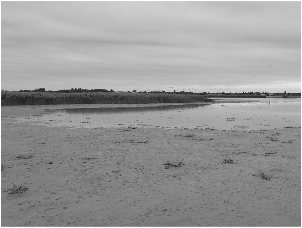
A soda lake in late summer, with a segment that has run dry over time in the front. Photo by the author.
These particular characteristics of soda lakes pose a challenge for monitoring. Since any fluctuations in water levels change the lakes’ chemical composition—and thereby the measurements that are taken—monitoring should ideally follow these hydrological dynamics. However, this would not be compatible with research staff’s working schedule, a researcher explained as we drove from one lake to the next. The biweekly monitoring frequency in summer is therefore maintained as the next best thing.
Added to the temporal dynamics of monitoring, threats to these highly distinct ecosystems create the impetus for a spatial approach that extends beyond the boundaries of the national park proper. As we moved along a string of lakes throughout the day, the researcher I had joined told me that additional permits were needed for monitoring some lakes that were located on private property and not leased to the national park. Several of these were barely recognizable as soda lakes, since they had degraded to the extent that they were covered in dense vegetation. This is the fate of the vast majority of (former) soda lakes in the region. Estimates suggest that about three quarters of them have ‘died’ (as some observers seeking to push the urgency of their disappearance in public consciousness have labeled it) since the 1850s. Moreover, most of the remaining ones are in bad condition (Kohler, 2024; Krachler et al., 2012).
While soda lakes are estimated to have existed for over 10,000 years, a few centuries of human intervention have had significant impact. From the seventeenth century onwards, several hundred kilometers of drainage canals were constructed to make the region suitable for agriculture. Structural transformations in agriculture that brought about a shift from cattle farming to the cultivation of vegetables—especially water-intensive crops such as maize and potatoes—has resulted in increased irrigation and an accompanying decrease in ground water levels. To assess whether drainage canals affect the soda lakes, we made a few stops along the canals on the monitoring route. These were not extensively monitored; we only looked at the direction in which the water flowed and briefly put the conductivity sensor in the water to see if any salts were being washed out.
This combination of observations and measurements taken from both lakes and canals inside and outside the spaces legally classified as national park shows some of the spatial complexity of the park in relation to its most significant ecosystems. In a similar vein, we see how monitoring is temporally complex in the pragmatic choice for biweekly monitoring, which balances researchers’ work routines with the dynamics of soda lakes. This shows how ecosystems in a protected area are characterized by spatiotemporal entanglements with their surroundings, which directly affect the object of conservation and thus need to be accounted for. The infrastructure for knowing soda lakes thereby does not only exist of the various instruments and assessments that inscribe the lakes into data (see Latour & Woolgar, 1986). Perhaps as important is for the infrastructure to also account for the dynamics of the lakes and their relation to their environment, situated in time and space. This applies to other conservation concerns in the national park as well, and I turn to an example of multiple temporal scales intersecting next.
Monitoring Vegetation—On the Temporal Dynamics of Monitoring and Management
As we sat in a coffee house in Vienna for an interview on botanical monitoring, I asked my respondent what makes the region botanically interesting. Their answer again reminded me of its ecological border position and associated diversity of ecosystems on a relatively small area. In particular, the areas around the soda lakes, including arid grasslands, are of botanical interest due to the relatively small number of (salt-resistant) plants that can thrive there. However, the area’s botanical diversity depends on functioning soda lake systems and their fluctuating water levels, as well as regular, spatiotemporally variable grazing that limits the growth of e.g. common reed (Korner et al., 2008). Grazing is therefore of importance for maintaining the cultural landscape of a ‘secondary steppe’ that is among the main characteristics of the region considered worth preserving (Berger & Fally, 1995, p. 113). Botanical monitoring in the national park is therefore more accurately described as a ‘grazing monitoring’ (Beweidungsmonitoring).
As both the botanist I interviewed and others I joined in the field emphasized, monitoring the effect of grazing on vegetation has a number of characteristics that make it distinct. Two people do the monitoring together, which—I was told—is uncommon in botany. The monitoring plots, too, come in pairs. This is to be able to assess the effect grazing has on the vegetation. The halves of each pair are located close together, yet one half is fenced off to make it inaccessible to (larger) grazers. This ideally allows for a comparison between plots where herbivores such as cows and horses do and do not get to eat. At the moment, around 60 plots are monitored on an annual basis. These are mostly located on what is called a transect, an imaginary line that runs from the center of a soda lake outwards. A large number of monitoring plots in the national park are located on transects along one soda lake.
To assess the effects of grazing, monitoring on these plots focuses on the variety of plant species and both their individual and collective surface coverage. To consistently monitor the same plots, researchers put down a 2×2m wooden frame, for which two corners are already marked in the field by metal plates. This should make sure that the frame is always put in the same position at a particular plot. The plot is further divided into four quadrants with a thin rope (see Figure 3), for each of which a separate inventory is made. When I observed this monitoring for a day, we spent several hours at the first plot, which contained a surprising diversity of species that, in the case of the inconspicuous grasses that form a large part of the Seewinkel vegetation, are not always easy to distinguish (not even for experienced botanists). However, it turned out that determining coverage—which not only includes plants, but also dead organic material, open soil, cryptogams (i.e. mosses, lichen, fungi, etc.) and animal feces—is not straightforward either. The two botanists independently estimated a certain percentage for each category by using markers on the wooden frame that gives a rough indication of how much 1% is. They also worked with implicit rules, such as that overall coverage would always be (slightly) more than 100% (since plants do not grow in neat rows). Still, and even though these botanists were experienced working together, they would regularly arrive at substantially different results. However, they did not just note down averages. Instead, they tried to convince each other, explaining their logics and looking at the plot from various angles.
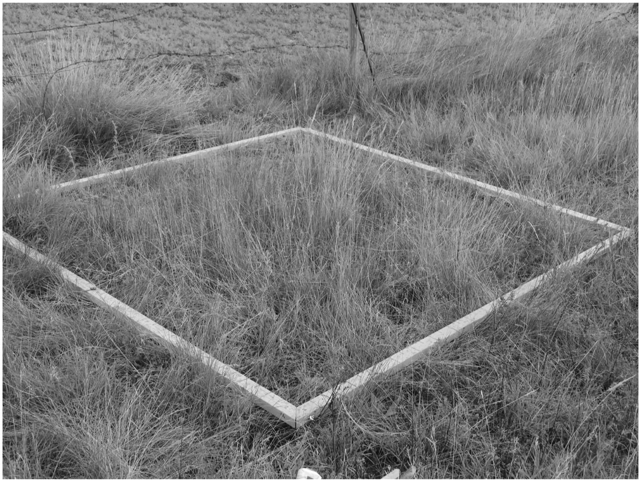
The wooden frame marking a monitoring plot, with a thin rope dividing the quadrants. The barb wire fence in the back marks the separation between a grazed and a control plot. Photo by the author.
Monitoring of grazing takes place between spring and late summer, moving along the transects from the outside in. This approach follows the spatiotemporal dynamics of the soda lakes; as they dry out, vegetation becomes increasingly accessible. The earliest dates thus focus on the meadows surrounding the lakes, moving increasingly close to its center later on. Along the transect, different plant communities are found, corresponding to the salinity of the soil and the time of year a given surface is under water. The number of different plant species also decreases as one gets closer to the lake’s center.
Ideally, each plot is monitored around the same time every year, but weather conditions can interfere with this logic. My first attempt to observe a day of vegetation monitoring was restricted from the beginning, as it turned out that all the plots scheduled for that day were still under water. To make matters worse, it soon started raining and we therefore spent the day in a local bakery, where the two researchers explained in theory how monitoring was supposed to work. Most plants are easier to identify when blooming, and certain species are only visible for a short period each year. When a specific plot is monitored may thus have significant effects on the results. Temporal variation in monitoring specific plots should therefore be kept to a minimum, and so extraordinarily wet years create problems.
Apart from the challenge of temporal consistency from year to year, grazing monitoring is of particular historical significance for the national park as a whole. A key reason for designating a protected area in the region, after all, had been to preserve the highly diverse arid grasslands that resulted from the use of soda lakes and their surroundings as common pastures. Over centuries, this tradition had created suitable habitats for various species of plants, insects and birds. Conservation initiatives in the Seewinkel region were therefore largely motivated by concern over the grasslands’ disappearance as cattle farming gave way to other forms of agriculture. Preserving and reintroducing grazing was therefore defined as an important function for the national park upon its establishment. However, concern about its effects on (especially) rare plant species meant that the national park was obliged to monitor the effects of grazing from the beginning. This monitoring continued for about twenty years, after which it went on hiatus. A handful of years later, it was restarted, ‘on the back burner’, as one national park staff member commented.
A botanist I interviewed explained that initial results showed that both plants of conservation concern and overall botanical diversity benefited from grazing. This is not only because herbivores keep rapidly expanding vegetation such as reeds in check, but also because the footprints of cattle and horses create minimal height differences that result in distinct micro-environments suitable for specific plant communities. However, the botanist considered continued monitoring worthwhile (and the national park administration agrees) since other changes, such as the effects of climate change, can be distilled from (now) over three decades of data.
In addition to illuminating long-term trends, monitoring results are used as the (scientific) basis for park management strategies, such as to determine where grazing should take place and how large the herds should be to achieve the desired results for vegetation, insects and ground-breeding birds. One botanist explained how results from monitoring in specific parts of the national park can inform management elsewhere. Nevertheless, it is a challenge to organize sufficient ‘grazing pressure’ to achieve the desired results. While the national park has a few herds of buffalo, cows, donkeys and horses—mostly traditional and presently rare breeds—it requires contributions from local farmers to have enough animals. For these farmers, maintaining the grasslands is not their first priority and financial incentives favor mowing rather than grazing. It is therefore not always easy to find enough animals for the distribution of grazing that would be desired from a botanical point of view.
Several temporal (and spatial) dynamics thus intersect in vegetation monitoring to shape the conservation knowledge and management infrastructure of the national park. They include multiple temporal scales, ranging from the long-term decrease in cattle farming in the region, to the intermediate timeline of monitoring showing longitudinal effects of grazing, to the year-to-year distribution of herds for management purposes, to the in-season dynamics of what, depending on the weather, can be monitored when. These temporal dynamics further show how, within the national park as a conservation infrastructure, temporalities of people, institutions, cattle and plants jointly shape how the question of whether the national park helps plant diversity may be answered. At the same time, this range of actors also shapes spatial scales of, for example, where grazing takes place, monitoring plots are located and vegetation can thrive. However, the negotiation of space becomes more complex with animals, particularly with highly mobile species such as geese.
Monitoring Geese—On the Multiple Spatial Layers of Animal Species Monitoring
The Neusiedler See–Seewinkel region is especially well-known in the public eye for the wide variety of bird species its diverse ecosystems attract. Overall, 142 species are believed to regularly breed in the region, and 370 have been sighted at least once (Dvorak, 2024). While not all of these species are subject to monitoring, the national park finances a substantial number of programs that range from ringing breeding and migrating birds to ones focused on species as diverse as herons and spoonbills breeding in the reed belt of Neusiedler See, hoopoes in vineyards and birds like northern lapwing and common redshank breeding around the soda lakes (Cimadom et al., 2024). Among these species, geese appear to have a special position as they are (to my knowledge) the only taxon monitored both as breeding birds and as winter ‘guests’. Moreover, the number of geese spending the winter months in the region is so substantial that it represents a high enough percentage of the overall European population to call into effect a monitoring and conservation responsibility. One researcher further described the winter counting program, which covers a wide variety of goose species as ‘the mother of all counting programs’ in the region.
The water surfaces of Neusiedler See and the soda lakes, together with surrounding grasslands and agricultural fields position the region including the national park as a significant space for geese migrating from Siberia and Scandinavia in winter. To know how many geese from which species do so, their numbers are counted once a month between November and February. Two of these counts are part of a broader, European survey. When I joined a national park staff member on one of these counts, we met an acquaintance of theirs who asked if we were counting geese. They confirmed by saying it was ‘Saturday before the Sunday closest to the fifteenth of the month’, which suggests how there is a fixed pattern to the counting dates. Yet this is not set in stone. Counts in Austria are synchronized with those in the bordering Hungarian national park. One of the counts I was set to join consequently had to be rescheduled from Saturday to Friday on short notice, since the Hungarians were organizing an event on the weekend. This meant that, in the words of one researcher, the counters were ‘flying blind’, as they had not had a chance to previously canvas the area to see where geese could be found, and I had to scramble to make it to the national park in time.
Arriving in time was a challenge because geese counts start early in the morning. All of the participating researchers need to be at their assigned location by 6:15, before sunrise. Geese sleep in large groups on open bodies of water and start leaving to feed on surrounding fields at the first light of day. One researcher explained that early morning was the only viable time for counting. During the day, they told me, geese fly back and forth between fields and on the fields they sit too close together to be counted. They further explained how they had tried counting in the evening, but since some geese only arrived at their sleeping place after dark this did not work either. An additional advantage to counting in the morning, they added, was that geese could be counted on the water and in flight, which allows for comparing the numbers.
The number of geese in the region during winter are vast and can easily consist of groups of hundreds or even thousands of animals. This creates challenges, both for each individual person counting and for generating good overall numbers. To make individual counts comparable, watches are synchronized (although one person observed that this is no longer necessary, with clocks on mobile phones) and each person monitoring keeps a list that includes their name, the date, weather conditions and possible disturbances (e.g. hunting), as well as the time, species, number and, where applicable, direction of flight of any group of geese. The counts I observed started with figuring out when there was enough light to be able to count. This usually took a while, but once the sun was up, things could get quite hectic.
At one count I joined, a researcher took me along several soda lakes. They used some colorful language when a group of several hundred geese they had almost finished counting flew off, which meant they had to start over. In the next moment, several groups of geese appeared simultaneously from different directions. The researcher continued attempting to count these groups while spending quite some time (as they later suggested, more than usual) on the phone coordinating with others. Counting the large groups in which geese occur can be quite a challenge (see Figure 4); one way researchers try to make it more manageable is by first counting a few groups of ten animals and then continue by counting them in ‘blocks’ of ten. Moreover, and even though one researcher joked to me that ‘it is called counting geese, not guessing geese’, numbers do not have to be exact. Geese counts are about orders of magnitude, and with thousands of geese in the area, mistakes in the order of dozens or even a few hundred are not considered to matter.
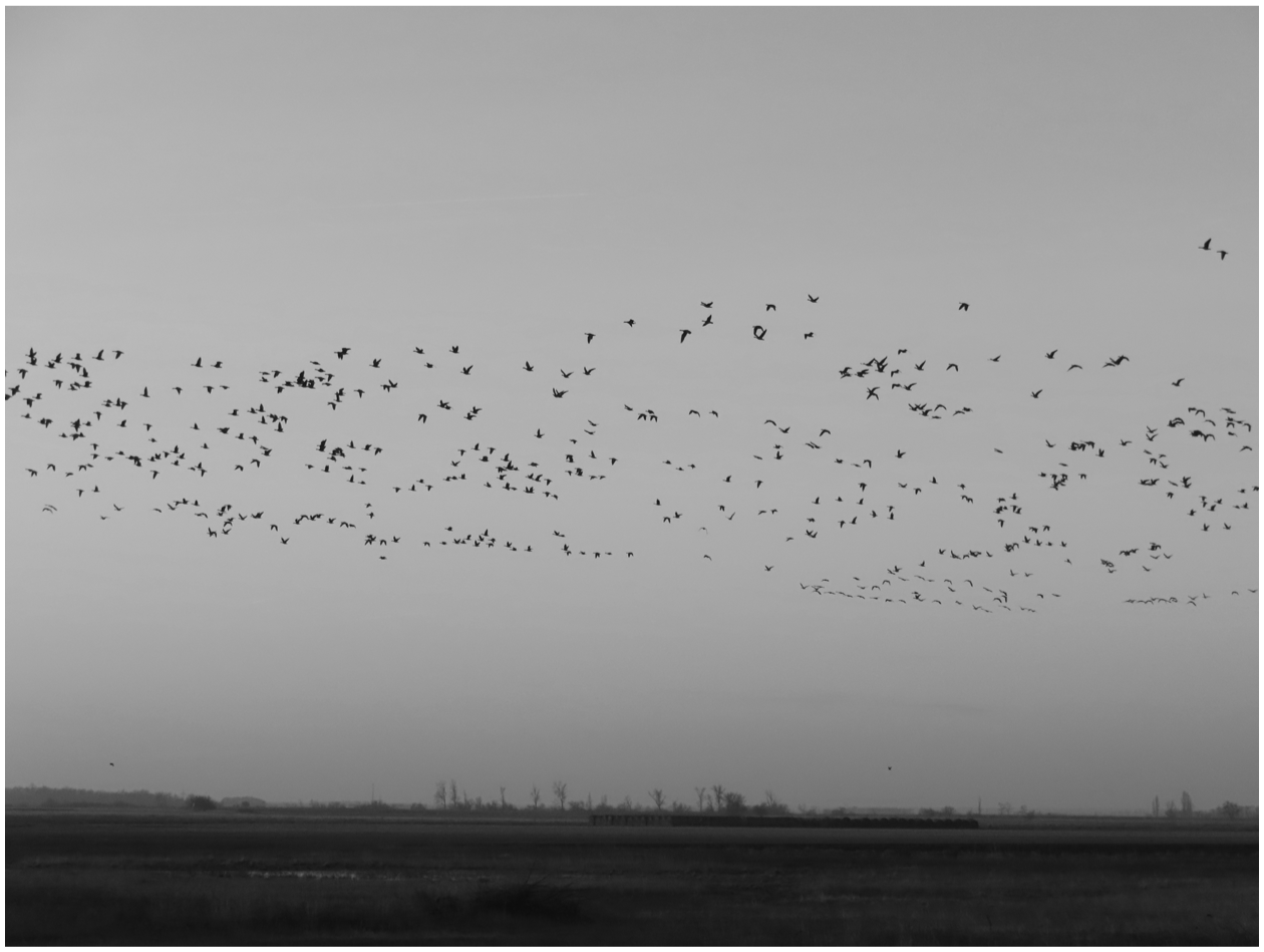
Part of a flying flock of geese, illustrating the challenge of counting. Photo by the author.
Nevertheless, to arrive at numbers that are as accurate as possible, geese counts involve a number of people and some coordination mechanics. Although I never had a chance to count all the people on the Austrian side, my estimate is that there were about fifteen, with several more on the Hungarian side. These people included national park staff, interns, staff of the biological station, and volunteers. Together, these people should ‘surround’ Neusiedler See and adjacent soda lakes, with each of them being responsible for a particular segment of the area. In some cases, this would include several soda lakes close to each other; in other cases, large bodies of water would be divided. In those cases, one person would count on one side of a landmark (which in the flat and open Seewinkel landscape could be a tree or a hunter’s blind), and someone else on the other. Time and direction of flight were noted to allow for comparison. This was partially done in the field, on the phone, yet a more systematic comparison of notes took place in a local bakery after the counting was finished.
Although only graylag geese breed in the region, several other species come to the region in winter, when greater white-fronted geese are the most common species. Counting these ‘winter guests’ serves various purposes. On a local level, it provides insight into the suitability of local habitats. When notes were compared, part of the discussion I witnessed was about finding explanations for the relatively low numbers counted that winter. Results of two of the counts also flow into a program to count all geese in continental Europe. Since geese are highly mobile, their distribution across Europe can rapidly change if the conditions in a particular region change. To know how the overall population of different goose species develops therefore requires a comprehensive European perspective. Moreover, geese may also move on a more regional scale, which is why the person collecting and analyzing the data for the Neusiedler See–Seewinkel region told me they also tried to obtain numbers from counts in neighboring Slovakia and the Czech Republic, which they considered to be part of the same (sub)population moving around this wider area.
In these countries, they told me, geese tend to frequent the reservoirs of hydropower dams. Indeed, although geese counts are run by the national park, they are not restricted to national park surfaces. Similar to the soda lake monitoring, they include other bodies of water. A significant portion of my fieldwork on geese counts as well as other aquatic bird monitorings therefore happened around a long-degraded soda lake that for years had been used as a public swimming pool for the local population—until it ran dry a few years ago. It has since refilled, but is now left to the birds. Like the monitoring of soda lakes, getting insight into how populations of species of monitoring interest are doing occasionally requires leaving national park boundaries.
The monitoring of a highly mobile group of animal species such as geese shows the multiple spatial (and temporal) scales of national park monitoring. Across these scales, multiple layers of scientific practice and of non-human life intersect. At a local level, monitoring requires an infrastructure for covering as well as possible the entire area and for generating as accurate numbers as possible while geese move through space. This infrastructure needs to account for the fact that Seewinkel geese do not stick to the borders of either the national park, nor national ones. Moreover, the tendency of geese to rest on water bodies is taken up to make the infrastructure workable. At the same time, this local monitoring infrastructure is tied into a broader European infrastructure for counting very mobile geese across the continent. This is the scale at which development of species’ populations independent of specific habitat conditions is assessed. Counts thus show in various ways how a national park is always tied into other spatial scales.
Conclusion
Protected areas are currently seen as critical instruments for an approach to biodiversity conservation focused on protecting a certain percentage of the Earth’s surface. However, the conservation success of protected areas are contested, as it is often unclear if and how areas designated on paper are actually protected in practice, and whether protection focuses on areas that can contribute most to species and ecosystem preservation (Cole & Johnson, 2025; Li et al., 2024). Measuring protected areas’ success through species and ecosystem monitoring is therefore considered of critical importance to conservation (Hoffmann, 2022), positioning protected areas as both knowledge and conservation infrastructures. Yet this intersection of knowledge and governance has been critically evaluated in the social sciences, not least due to the reductive understanding of nature it presupposes. From this perspective, counting species is a biopolitical operation that results in a reactive and reductive approach to conservation (Lorimer, 2015; Youatt, 2015).
In this article, I engaged with the question how protected area monitoring frames conservation by focusing on specific monitoring practices in a single protected area, Neusiedler See–Seewinkel National Park in Austria. While I conducted ethnographic observations of a wider range of monitoring programs, here I focused on three salient examples: the monitoring of soda lake ecosystems that are highly characteristic of the region, the monitoring of vegetation in relation to grazing as a management strategy, and the monitoring of geese in winter, for which the national park is a significant habitat. In this particular naturecultural region, where the national park is scattered within a landscape still used for agriculture and many of the elements considered worth preserving result from human intervention, monitoring must be understood in terms of the interaction of many different actors, species, and conditions. More specifically, the three monitoring programs on which I reported here are shaped by the formal organization and regulation of the national park, biologists’ work routines in doing research, and the ways non-human organisms shape and are shaped by time and space. Within distinct monitoring practices, these various actors thus enact multiple spatialities and temporalities that jointly make the national park beyond its formal boundaries.
The national park was enacted in the form of multiple spatial scales in both its formal organization and in monitoring practice. It matters to operations in the field that the national park consists of a ‘rag rug’ of leased parcels of land embedded in an agricultural landscape. As a result, not all monitoring can be done within the boundaries of the national park proper and in some cases has to explicitly consider the effects of activities beyond its boundaries, such as the effects of drainage canals in relation to soda lakes. Spatial considerations may also feature into management decisions, for example when botanists give their informed opinions on where herds of herbivores should be employed. At the same time, space is also ordered by the logics and routines of scientific work, as when botanists map out transects and plots for monitoring (including control plots). Similarly, goose counts feature in several questions of scientific interest at the local, regional and European levels. Goose monitoring is also a primary example of how monitoring, finally, needs to adapt to the spatial scale of its living objects. Researchers need to canvas the area, divide who counts what and consider directions of flight to make sure they get accurate counts of these highly mobile animals.
Multiple temporal scales result from various dimensions of national park monitoring. The longitudinal monitoring of the effects of grazing, for example, is tied to the history of the establishment of the national park itself, and both form a response to long-term transformations of agriculture in the region. Both for soda lake monitoring and vegetation monitoring, researcher’s desire for a consistent monitoring frequency run up against the unpredictable dynamics of ecosystems and the weather. The desire for consistent counts that are comparable across years also informs the scheduling of goose counts, and the time of day these are conducted is determined by how geese behave.
To extend this observations beyond the few monitoring programs I could present here, a national park staff member reminded me how ‘neither a black-tailed godwit, nor a catfish or a great white egret knows about any of these [administrative] categories’ of the boundaries of a national park or the Republic of Austria. Hence, this staff person continued, it would be ‘meaningless’ to count species in national park areas alone. A similar observation may be made about time: To insist on looking at vegetation on a specific date, even if it is under water, or to try and count geese during normal working hours, would make just as little sense. Looking at national park monitoring as a multispecies activity located across multiple temporal and spatial scales and dynamics consequently transcends the formal boundaries of the protected area as knowledge and conservation infrastructure. This observation holds some lessons for both social studies of science and conservation practice.
On the one hand, monitoring forms a distinct knowledge practice that entails different dynamics than the laboratory sciences that have been the main interest of STS research. As Lorimer (2008) has observed, there are still lessons to be drawn from practices of field research. I propose that seeing monitoring as a multispecies activity challenges the idea that conservation in protected areas is reductive, since it lays bare how researchers engage with other forms of life not as a hindrance to research practice, but as something they can mobilize for knowing the landscape and its dynamics better. In addition, by considering multiple spatialities and temporalities in monitoring includes the institution of the national park (in a formal, legal sense), which suggests a new direction for multispecies ethnography beyond its focus on practices—especially since various forms of regulations, strategies and other institutions shape the lives of more-than-human species in important ways.
This observation is important for conservation practice, too, but in a reverse sense. Monitoring as a multispecies activity suggests that a protected area as knowledge and conservation infrastructure cannot only be formally designated or evaluated through counts and measurements. Considering how more-than-human lives for which protection is intended transcend protected area boundaries implies that it is critical to consider conservation in a broader spatial and temporal sense.
Footnotes
Acknowledgements
I would like to thank all staff members and researchers in the Neusiedler See–Seewinkel National Park who made their time and insights available for my research. Any opinions expressed in this work are solely the author’s and do not necessarily reflect positions of either research participants or the National Park administration.
Funding
The author received no financial support for the research, authorship, and/or publication of this article.
Declaration of Conflicting Interests
The author declared no potential conflicts of interest with respect to the research, authorship, and/or publication of this article.