
Abstract
This article examines a science-policy interface from the age of empire. Focusing on the ‘Anti-Locust Research Centre’ (ALRC), the British Empire's pioneering attempt to monitor and eradicate locusts and protect colonial agriculture, the article approaches the ALRC as an information system, exploring its origins in the 1920s to its heyday in the 1950s. It argues for the value in distinguishing between the organisation's ‘information territory’ – the domain in which its claims of knowledge were made – and its ‘data terrains’ – the material environments and experiences from which its data was gathered. Through a combination of archival research and original data visualisations, the article examines the place of the ALRC and its archive within conceptions of space, the working of data, the exercise of power, and the histories of colonialism and war. Doing so allows us to interrogate contemporary claims about the extent and capacity of the ALRC's performance, and to reveal the multiple spatial and temporal obstacles that constrained its ambitions. With an eye to debates about science-policy interfaces today, it uses the ALRC story to reflect on how territories and terrains wholly outside the experience of locusts themselves affected its judgements, forecasts, and operations.
In a grey and unremarkable building in southwest London – set back from the road, and with no signage to catch the eye – the Natural History Museum stores part of its vast offsite collection. For the past twenty years two large rooms have housed the records of the Anti-Locust Research Centre (ALRC), a former UK-government organisation with long links to the Museum itself. The archive sits quietly now, and predominantly in darkness (the building is closed to the public), but from the 1920s until the 1970s these materials formed the nerve centre of an undertaking that spanned the world, from West Africa, through the Middle East, to India and Central Asia. The ALRC led global investigations into the biogeography and periodicity of locust swarms. It was especially dedicated to seeking out and destroying the desert locust (Schistocerca gregaria): a commitment, often framed as a long ‘locust war’, of which successive British governments were vocally proud. At times it was animated by a palpable sense of mission. Never before, it would claim, had this biblical pest been subject to such large-scale surveillance or control.
By the 1960s the Centre employed more than 60 staff in London, but its work directly affected the lives of many thousands more: entomologists, of course, but also toxicologists, photographers, meteorologists, cartographers, laboratory technicians, administrators, drivers, mechanics, village elders, tribal shaykhs, day labourers, ‘locust scouts’, soldiers, pilots, and politicians, and across three continents (Asia, Africa and Europe). Making sense of this interdisciplinary project requires a collaborative and interdisciplinary approach; the very richness of its records invites exploration at different levels of analysis. 1
This article examines the ALRC as an information system, and as an example from the age of empire of what would later be called a science-policy interface. It looks back, past the apex of its activities in the 1950s and 1960s, to its origins in the 1920s through to the Second World War. It focuses on the establishment and operation of the ALRC project through a study of its archival documents. These often contained correspondence, which themselves contain data, out of which a view of locusts across Africa and Asia was constructed by the organisation's London centre (one of the few locations within its orbit where wild locusts were unlikely to ever be seen). Writing as a historian and as an ecologist interested in data visualisation, we are interested in the place of the ALRC and its archive within conceptions of space, its data practices, the exercise of power, and the histories of colonialism and war. This brings us into dialogue with literatures and concepts across history, critical cartography, and data studies, in order to surface, understand, and characterise a story that is often flattened and simplified within scientific and more biographically orientated accounts.
Indeed, much of the existing writing on the ALRC focuses on the converging ambitions of its most influential figure (and ‘father of modern acridology’) Sir Boris Petrovich Uvarov and the wider international entomological community; it also commemorates the achievements of its large-scale information system (Baron, 1973; Roffey, 1970; Uvarov, 1943a). Such works offer a partial insight into the nature of the organisation, and especially the activities involving information processed from data, and data collected from the field. At various points since our investigation began in 2016, museum professionals and scientists have asked us about the potential of extracting historic data from the ALRC archive in support of current research in entomology or climate science – that is, to see if this vast and partially catalogued collection might be resuscitated to work in a similar way to how its creators originally intended. Such data extraction may indeed prove possible (our work has required us to re-build connections between archival materials which had been broken during successive relocations of the archive), but it is not our focus here. 2 Instead, this paper studies the ALRC's data setting, not the data set (cf. Loukissas, 2019). In the process of accumulating data, many contextual and situated aspects of the data were lost. The ALRC formed a more singular, curated narrative by flattening data that was sourced from diverse and distant localities. Focussing on the data and data practices allows us to shed new light on how the ALRC built and defended its extensive zone of operations, spanning multiple jurisdictions and political authorities, and how the circumstances and conditions of late colonialism and war intertwined with its growth. Borrowing a phrase from Stoler and Cooper (1997), our goal is to unflatten understandings of the ALRC and its outputs, by investigating how data was collected and inscribed on one continent, passed through varied communication networks to another for information processing and reporting, and then often relayed back to the continent from whence data originated in the first place.
To explain this unflattening, we propose the concept of an ALRC ‘information territory’, building on the work of geographer Stuart Elden (2013). Elden defines territory as the transformation of landscape into a new and modern sensitivity around space: a bundle of relations connecting political theory, legal jurisdiction, sovereignty, and technologies such as surveying, cartography, and the census. More recently, however, Elden (2017) has invited scholars to also consider ‘terrain’ in order ‘to make work on territory account more fully’ for the physical materiality of the earth, and to consider how this both enables and frustrates political, economic, and strategic projects. In this conceptualisation, the distinction between territory and terrain is one between political and legal units on the one hand, and the material experience of the places they encapsulate on the other. We examine these distinctions and alternative experiences by following data and correspondences, often through the conflicting claims and ontologies they represent. The term ‘terrain’ is most associated with physical and especially military geography, where, as ‘topography’, it is normally considered as a factor affecting military outcomes. As Gordillo (2018) notes, however (and as Elden reminds us), terrain has remained under-theorised as a concept in these fields, and scope remains to use it in an expanded sense to consider the constraints acting on state projects; to take it beyond the built environment and urban contexts in which it is most applied; and to engage with Derek Gregory's suggestive concept of ‘corpography’, in which the lived experiences of soldiers (rather than the abstractions of surveillance or logistics) are seen as crucial to understanding the spaces of war (Gregory, 2016). All these extensions seem particularly apposite in the case of the ALRC, which operated in environments far removed from urban centres; where connections between the geophysical and the geopolitical were of daily concern; and in which, as we shall see, not merely military metaphors but actual military organisations and campaigns played a central part.
This paper transposes Elden's ideas into the ALRC's ‘information territory’ – the domain in which its claims of knowledge were made – and its ‘data terrains’ – the material environments and experiences from which its data was gathered. For the ALRC, its information territory was mapped, certain, and international in scope. For locust officers working at the information front, by contrast, the data terrains were challenging, ambiguous, and sometimes hostile. We posit the ALRC's information territory as a political technology, coarse-scaled and operating in a rhetorical space that flattened the data terrain, within which data collections mediated connections to the heterogenous dimensions of real-world environments and experiences. It invited exploration of regions within the terms of science and anti-locust operations, in order to expand and further establish the information territory, a depiction somewhat aligned with the process of the ‘commodification’ of world regions within scholarship on colonial cartography (Braun, 2015, 2024). By exploring the information territory that the ALRC claimed, with an eye to the work carried out in the vicissitudes of its data terrains, we seek to chart relations among the ALRC's data, data sources, its analysis, and its dissemination as information.
Doing so also serves to reveal the socio-technical workings of this science-policy interface, and to revisit the claims made at the scale of its information territory in terms of the realities of the many terrains from which that data was taken. This also permits us to re-interrogate the data from which the terrain was removed. Questioning the status of maps in this way, through a consideration of data practices, connects our work to scholarship in critical cartography and data studies (e.g., Edney, 2018; Stoler and Cooper, 1997; and Gitelman, 2014); but our own disciplinary backgrounds have also combined in a project-specific approach that has developed through improvisation within the archive as a working space, and porting some concepts from ecology and ecological methods into historical and geographical analysis. At times, our work has employed rudimentary methods such as physically weighing the abundance of documentary material, or developing methods of mapping documents’ spatio-temporal flows, and then employing understandings of these dynamics to reconceptualise the ALRC's knowledge claims in light of the technocratic system it had itself created. In this sense, rather than focusing on mapping practices themselves, we look through maps into the epistemic practices of ‘documenting’ (Gitelman, 2014) as a gateway into the data practices and communication networks of the ALRC. In this paper, we approach the various forms of documents within the archive as interfaces between data and information, and so provide insight into both the data terrain (made visible through field notes and communiques) and the information territory (constituted by maps, reports, and bulletins). We term this aspect of our investigations an ecology of information, constructed through a focus on the distribution and abundance of data, and the agents and interactions involved in information production and consumption. As we shall demonstrate, understanding this ecology is crucial to deconstructing the information territory through its relationship with, and representation of, the data terrain. We believe that our ecological approach – however crude – provides insights into relationships between power and knowledge production (see also Stoler and Cooper, 1997: 21) by following the paper trail across continents, and from field notes and correspondences that were latterly synthesised into information bulletins. Our approach allows us to explore various forms of incompleteness that arise through the processes and assumptions embedded in locust research by the ALRC.
After introducing the ALRC, its archive, and our joint investigation, we begin with a discussion of contemporary claims about the extent and capacity of the ALRC's information territory. A second section brings archival material and new visualisations of the ALRC archive into counterpoint, to peer behind the curtain at the workings of this system. The third section focuses on the system's data terrains, revealing multiple spatial and temporal obstacles that constrained its ambitions. Our concluding section returns to consider the ALRC as an early twentieth-century science-policy interface, and reflects on how multiple territories and terrains wholly outside the experience of locusts themselves affected the ALRC's information territory and the conduct of its anti-locust operations.
Introducing the ALRC and its archive
While separate colonial authorities had long devised ad hoc responses to individual locust outbreaks, the British government only recognised locusts as a serious threat requiring coordinated management in the wake of the First World War. It initially entrusted investigative work to a small body of scientists based in the Natural History Museum (then part of the British Museum) and in the Imperial Bureau (later, Institute) of Entomology. In 1929 the ‘Locust Sub-Committee’ of the UK Government Committee of Civil Research – a new body tasked with making recommendations on the locust problem – created what would become the forerunner to the ALRC and placed it under the Bureau's Director, Sir Guy Marshall. Boris Uvarov was charged with supervising its investigations. Locust spatial and temporal distributions are dynamic (increases in locust density trigger swarming behaviour and large-scale movement from ‘breeding areas’), and the ALRC was tasked with understanding how recession-plague fluctuations played out across local and continental scales. From the beginning, protecting colonial agriculture was a central objective.
Uvarov's drive to centralise data collection and forecasting activities laid the foundation for a global information service, but its internationalist credentials were always in tension with its ties to the Colonial Office and, especially in the Second World War, to the military, when a ‘Middle East Anti-Locust Unit’ enabled the Centre to run its own paramilitary locust control campaigns. Nonetheless, it took pride in its position as the leading body to issue locust warnings worldwide, and in the postwar period it supported a Desert Locust Survey to maintain this role. But when the ALRC was incorporated into the Centre for Overseas Pest Research in 1971, and then the Tropical Development Research Institute in 1983, budgetary constraints and the broader focus served to dilute British expertise in locust control. Responsibility for the information service passed to the United Nations Food and Agricultural Organisation in 1978, and the archive to the UK's Natural Resources Institute in 1990, later part of the University of Greenwich.
When the Natural History Museum acquired the archive in 2005, it took on the entirety of the ALRC's paper-based information system. At its core, that working collection consisted of physical notes and reports of locust sightings from around the world, sent to ALRC to be filed, plotted onto maps, and analysed to produce forecasts, issue warnings, and offer advice to control campaigns. The data was also revisited for successive in-house biogeographical studies. Joyce Magor, who worked in mapping during the ALRC's heyday and who met with us inside the relocated archive at the start of our investigations, recalled the locust reports being ‘stored in a wall mounted hanging file system, alphabetically in chronological order by source … [O]ur files ran from left to right in rows and we wasted time running back and forth to find specific countries as there was no place to label the rows’ (private correspondence 2016). These are the documents which, upon accession, were re-filed into 336 archive boxes across 18 bays of compactor shelving. Metal filing cabinets hold an additional 13,000 photographs and around one hundred 16 mm films, while a second room of map chests holds approximately 18,000 maps detailing locust distributions and weather and climate data. Most of this overwhelming collection is only catalogued to box level, greatly complicating closer study. Whole sections are not catalogued at all.
This article reports our work on a suite of focused investigations into the data and information underlying the knowledge claims made by the ALRC. With limited access to the site, we often had to work fast, improvising methods as new research questions arose. It became clear that we would need to build our own catalogue to understand how the archive's various components had once functioned together, when it was a live set of information continually updated. A further challenge to researching the ALRC is the multi-scalar nature of its operations, as shown by the creation of a single data point, wherein a locust swarm sighting somewhere in Afro-Eurasia might become, successively, a narrative report, a written letter, a mailed packet, data transcribed onto a map, an inference of locust dynamics, and finally a telegraphic or written warning or forecast. We have written elsewhere about the experience of anti-locust campaigns on the ground in East Africa and the Middle East, their connection to the histories of regional states, and the resulting frictions between local, national, imperial, and international actors (Fletcher, 2024). Instead, this article focuses on Britain's ALRC as an ecological system consuming data and fixing information, though our picture is also informed by the work of our collaborators Dr Kat Brown (a forensic entomologist) and Dr Amanda Thompson (an artist) developing studies on other components of the archive.
Claiming the information territory
In 1943–1944, at the height of new locust plague, Boris Uvarov published a series of articles lauding the ALRC's achievements (Uvarov, 1943a, 1943b). In these, he made clear that he fundamentally conceived of the Centre as an information system – he sometimes called it an ‘information service’ – and made numerous claims as to its extent and capacity. Across the 1930s, he argued, ‘intense efforts’ to ‘collect data’ had built a system through which ‘information’ was ‘received in London from over 40 countries’. Plotted onto charts, this had enabled the London Centre to identify the ‘few particular areas’ from which ‘nearly all’ locust outbreaks originated. The ALRC's gaze and competence thus ranged across space and time: its ‘main duty’ was ‘to keep abreast of all developments’ across the locust's habitat ‘and, by comparing them with the past, to forecast what areas will be in danger’ in the future. ‘News of locust movements are cabled to London by all countries every fortnight’, he added, ‘and monthly forecasts are cabled back for the guidance of local Governments’. 3 This was only possible, an official memorandum explained, because the ‘centralisation of information in a single institution’ had enabled British experts ‘for the first time in history to obtain a complete and clear picture of the locust situation in the entire continent of Africa and in south-west Asia’. 4 The ALRC would even go on to claim that victory over the great locust plague of 1942–1948 was only possible because of this unique information system: an outcome, in a line Uvarov himself often repeated, that ‘more than justified’ the £5 million spent on surveillance and control during the war. 5
This was the information territory of the ALRC. It was substantially created at the London Centre itself and distributed through its own geography and networks via written correspondence, conversations, publications, and maps. It meant very little to the desert inhabitants and agricultural communities whose lives were most impacted by locusts (for whom the information territory, being principally located in cupboards, filing cabinets, and map chests in London, had no substance), but it was immensely powerful, nonetheless. Through the information territory, data and information coalesced into something new, and which served to increase the capacity for organised anti-locust campaigns. Through the centralisation and analysis of data on the desert locust, and the subsequent dissemination of forecasts, the ALRC laid claim to an information territory that conferred authority over and enabled action across multiple political jurisdictions.
This information territory contained its own gradations and subordinate units, arranged hierarchically. As Uvarov explained to Nature in 1943, the ALRC bridged countries with ‘efficient local entomological organisations’ (such as Egypt, Palestine, Sudan, and Kenya); countries with modest organisations but ‘resources insufficient for large-scale operations’ (Persia/Iran); and countries with ‘no organisations capable of undertaking locust operations’ (including most of Arabia and Ethiopia). The in-flow of data, however, and the authority that flowed from its possession, enabled the ALRC to see and to issue forecasts across these spaces, and indeed into ‘areas which used to be inaccessible, so that now the developments in the whole region can be fitted into a single picture on which forecasts … can be based’. The ‘large and important blanks in the maps of locust movements’ were being filled (Uvarov, 1943a).
Within and through the information territory, ‘a clear picture of the whole problem became available’, so that ‘every country has received a timely warning, and these warnings have proved to be correct’. At the peak of activity in 1953–1954, the Centre's “Geographical Section” received 1363 reports from at least 38 different co-operating countries.
6
With steady improvement, Uvarov claimed as early as 1943, the ‘unified reporting system … now covered
In these articles, Uvarov linked the efficiency, certainty, and power of Britain's war on locusts to the existence and capacity of the ALRC's information territory. There were specific rights and forms of authority that the information territory conferred, including the capacity to launch interventionist locust ‘Special Missions’ to Saudi Arabia and Ethiopia. It enabled the production of abridged reports of the overall ‘locust situation’ through which, in turn, strategy was considered and communicated. States that failed to co-operate with the information territory became ‘information blanks’. Thus the sheer breadth of the ALRC's vision across ‘locust space’ and forward and backward through ‘locust time’ became its unique asset and the basis for its interventionist prerogative: this approach alone ‘supplied a sound scientific basis for solving the problem’ (Uvarov, 1943a). Yet even as the ALRC staked claim to its information territory, it seldom acknowledged the data terrain, despite the substantial impact that physical, human, environmental, political, biological and cultural factors had on determining what was seen, and where. In the work of countless locust officers, cartographers and analysts, the materiality of the data terrain was filtered out, as observations become ‘inscribed’ in coordinates, symbols, notes, telegrams, reports, and maps. 7
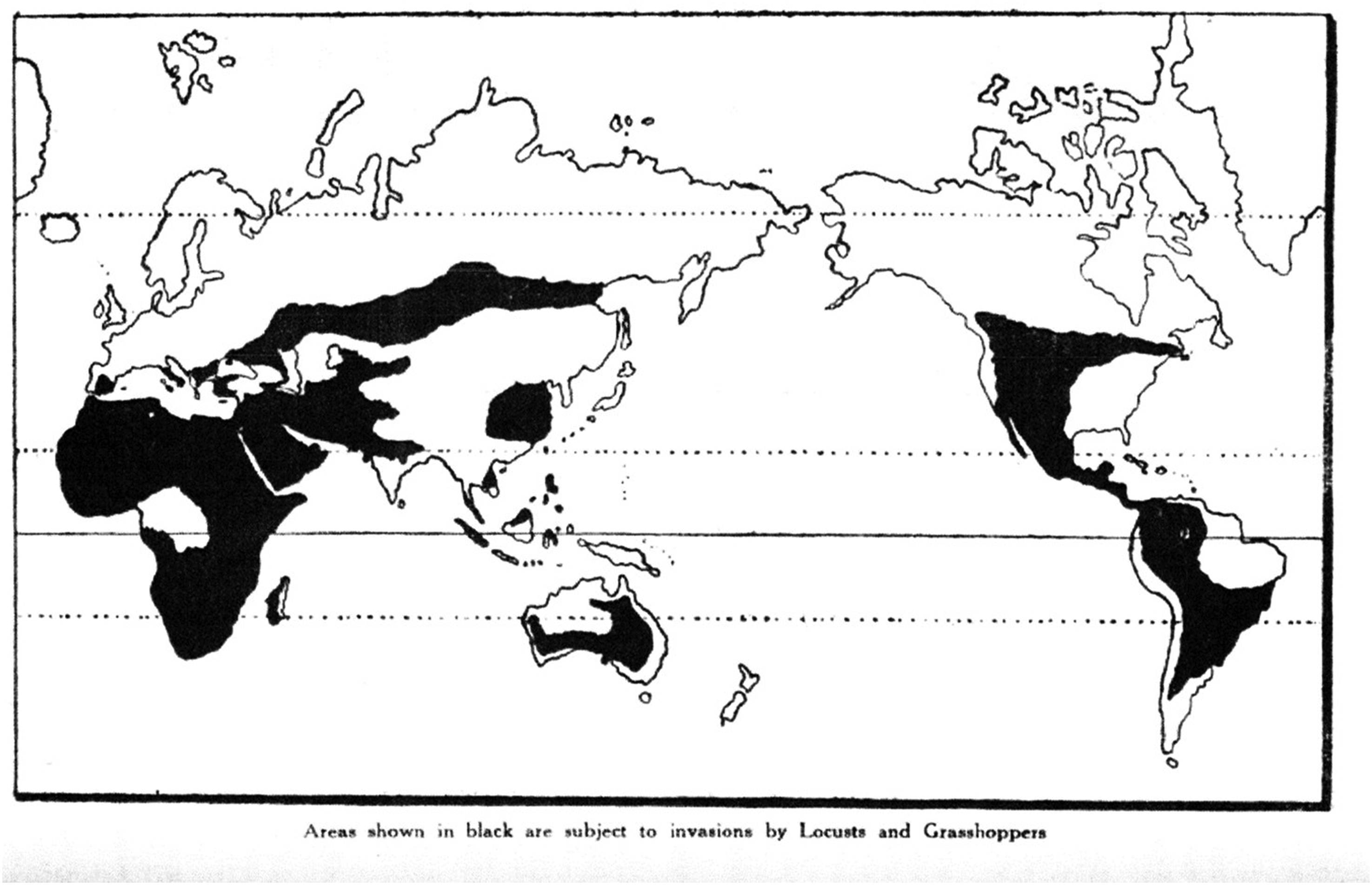
Uvarov and the Centre deployed numerous visual strategies to communicate the extent and capacity of their information territory. The first was the routine habit of circulating world maps of the locust's recession area without reference to political or administrative boundaries (Figure 1). This was the locusts’ territory. The Centre's own biographical research had shown that ‘the whole region from India to East Africa forms an interconnected migration area’, over which the information territory had made it possible to develop and deploy ‘a single plan embracing all the countries involved’ (Uvarov, 1943a): maps such as Figure 1 served to underline the sheer expansiveness and fluidity of the ALRC's gaze and activities. A second visual strategy was the ALRC's production of its own 1:10,000,000 scale ‘Locust Maps’ onto which swarms and hoppers were plotted by hand. Each carried a distinct legend (standardised ‘conventional signs’ for reporting locust swarms) and centred on locations that were key nodes in the information system, but were otherwise stripped of topographical features. 8
This mattered because the ALRC's information territory had no direct political authority. Its real-world operations were neither coterminous with the locust's habitat, nor with the boundaries of the political units through which the locusts passed – though they had a relationship with both. Instead, the information territory worked above political territories to generate its own spatial properties through negotiation, proposing or assuming conventions, and – most importantly – through the act of turning information into data, data into forecasts, and forecasts into advice or proscriptions for action. Indeed, it was this very act of distancing the information territory from the data's contextual settings that made it such a powerful tool for the ALRC, as this underpinned its ability to be readily communicated to political audiences of imperial administrators, bureaucrats, and statesmen.
As Steven Connor has argued, the act of ‘counting’ reduces the dimensions of the real world while simultaneously affording ‘access to a vast multiplicity of mathematical relation … performable on different scales’. That is, once data points shed the residues of their prior situatedness, they become compatible with other data components to supercharge macro-scale analyses and forecasting. 9 For the ALRC, this involved reshaping the various terrains and systems of classification that each correspondence or observation originated from, in order for the data to operate within the geospatial and classification systems the ALRC developed, mapped, and subsequently summarised. Reid and Sieber (2020) refer to this as information loss and subsumption which, in our context, was critical to how the ALRC was able to present itself as a professional and calculated (rather than chancy or frantic) endeavour. Its information territory was simultaneously information rich through connection with other data (a fact which helped it to suppress dissent or to foreclose and deflect criticism), but it was also information poor owing to both the disconnection of that data from its context of collection, materiality, and situatedness, and the information lost through recasting and transcoding ontologies into a single scheme: that of the information territory.
Contemporaries even remarked on this fascinating contradiction between information richness and poorness as a feature of the ALRC information territory at the time, noting how it worked to reduce the dimensionality of data and ‘distil’ its terrain. As a 1962 account of locust reports being made in the field observed: From a little block of offices in South Kensington, [Boris Uvarov] mapped, plotted, negotiated, schemed, conducted research – and became so well known to those miles away from SW7 that there are said to be Tauregs, Borans and Somalis who know no words of English except ‘Latitude’, ‘Longitude’, ten numerals and the name of the man at the bottom of the telegram to whom they refer as ‘Uncle Boris’.
10
While the information territory had the objective of transcending political borders, it proved incapable of transcending politics. By the late 1940s the ALRC faced numerous critics and competitors, from concerns about its costs to nationalist demands to withdraw cooperation from an organisation associated with British oversight and interests. In this context, the information territory served not merely to claim but also to attempt to defend the scope and the logic of ALRC interventions: justifying its expense, seeing off its rivals, and expanding the reach of its influence. And yet, its archive also affords private glimpses of uncertainty and doubt excluded from its public pronouncements. The Centre's own major cartographic analysis of the 1930s and 1940s, for example – later identified as ‘the best documented and most representative of both the plague and inter-plague periods’ – was not completed until 1956.
11
D. Vesey-Fitzgerald, acting Chief Locust Officer in Arabia during the war, expressed frustration at the difficulty of judging the campaign's success: The assessment of results is fraught with difficulty owning to the absence of recognised standards to apply, and to the state of mind acquired by the observer after weeks in the wide-open spaces covered with a living carpet of hoppers.
12
In Figure 2 we show some of the core aspects of this problem. 13 One of the most voluminous components of the archive is its map collection, yet for all the maps’ intrinsic interest they present significant challenges to analysis, being so individually large, so collectively numerous, and so fragile. By chance, however, we found an in-house ‘Catalogue of Maps of the Occurrence of the Desert Locust’ wedged between two of the map cabinets, which we infer to have been created c.1960–1964. It records the region name of the base map and whether adult locust, hopper, or egg distributions were mapped. The maps cover great stretches of the ALRC's early decades of operation, sometimes with multiple maps existing for a single month. In Figure 2 we have used this catalogue to visualise the cumulative and ‘comprehensive’ vision afforded by the ALRC's information territory. As data points were added over time, the map library for Africa was incrementally ‘revealed’. The catalogue deals in fixed geographical blocks which have only an indirect relationship with political boundaries and locust biogeography: they are more properly a function of the information territory. They also have a powerful flattening effect, conveying a consistency in both the frequency and quality of data flows, and projecting a strong impression of the Centre's capacity and vision.
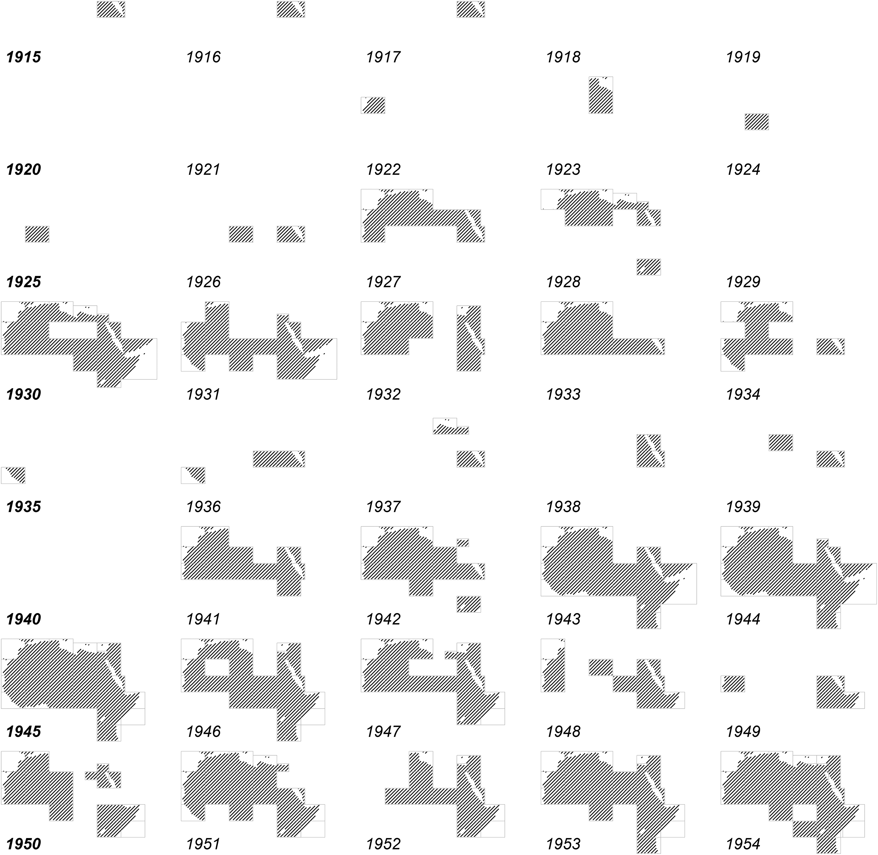
Visualisation of the Anti-Locust Research Centre (ALRC) African map catalogue showing regions in which at least one data point was catalogued for Adult Locusts or Hoppers. In some years, the information territory has no extent due to a lack of data and/or a lack of locusts. Asian distribution not shown. International Map of the World, 1:2,000,000, Polyconic Projection. Produced with R (R Core Team, 2023) and the sp (Bivand et al., 2013), spatial (Venables and Ripley, 2002), maps (Becker et al., 2022b), mapdata packages (Becker et al., 2022a).
But the map catalogue is also a provocation: from our perspective, it is an example of the vital work that the information territory was doing. Consider the example of a single data point, such as the location of a locust sighting (which may or may not have had accompanying coordinates), and which may have been the only sighting in that month (or even that year). Here, the information territory involves both a reduction in information content (loss of context, meta-data, or some abstraction of abundance to an ordinal scale) while simultaneously producing an expansion in its extent. Because ALRC forecasts were often made at the national scale, our single data point concerning, say, the Danakil Desert region of Ethiopia at LAT_LONG, results in the shading in of a map sheet block, and the broadcast warning, ‘ETHIOPIA BEING INVADED’. Indeed, the data may not even have originated from within the shaded area itself. In this way we can see how the information territory absorbs and filters uncertainty to assert, with some re-scaled assurance, an alternative picture of data, a picture containing the ‘silences’ and ‘distortions’ that Harley (2009) emphasised as crucial when understanding the presentation of territories and commodities. As opposed to deriving its power from a single political authority, the information territory arose from precisely this centralisation of data – even as it was physically located outside the geographical, political and ecological territories it encompassed. The information territory emerged from rescaling, reshaping, and remodulating data from the terrain.
All this makes the case for a closer examination of what lies beneath such flat, grand cartographic statements of reach, panoptic vision, and authority. If maps ‘emerge through practices and have no secure ontological status’ (Dodge et al., 2009), then the wartime ALRC is an especially rich subject for exploring the philosophical underpinnings of cartography, given the great innovations occurring in emergent cartographic practices at precisely this time. Viewed in this way, the information territory operates as a somewhat ‘glossy’ vision of what the organisation sought to attain (which in itself was always depicted as having always been the case). This might have been necessary: a stoically literal description of the situation would never have attracted the resources or support necessary to develop the organisation. But this nonetheless made the information territory central to questions of legitimacy and to the act of seeking to develop and deploy a monopoly of knowledge. To put this in terms of academia itself, the ALRC deployed knowledge generated from within a discipline of its own making, not derived from a single distinguishable science or method. The ALRC approach was mutually conceived through a pragmatic approach to developing methods in relation to its study objects (see Gitelman and Jackson, 2013) – and all against the backdrop of powerful extrinsic factors. Colonialism added a particularly fraught context, and one that necessitates interdisciplinary study as the logics of science were woven into by those of empire, racism, state power, and war. As we shall see, the ALRC was issuing advice and making forecasts in the thick of them all.
Building the territory
In their work on information infrastructures, Karasti et al. (2010) observe that the work processes surrounding data are too often under-described and under-documented. For its part, the ALRC was opaque about how its ‘information service’ – so central to its rationale – actually operated (Roffey, 1970). Read critically, however, its archive contains valuable behind-the-scenes glimpses into these processes. We believe there are many uses in distinguishing an information territory and its data terrains, but this is not to suggest that issues of materiality and situatedness are exclusively a matter for data terrains (and those locust breeding grounds) at the periphery of the ALRC system. The London Centre had its own terrain, too, determined by the habits of documentation, collation, archiving, and assessment practiced there.
From the outset, organising ‘a regular system for the collection of locust information’ and ensuring a steady flow of updates was prioritised as the major task of the ALRC (Roffey, 1970). In 1929, the very first interim report of the government's Locust Sub-Committee urged ‘the collection of information regarding the Desert Locust from all possible sources’ to commence ‘without further delay’. 14 Uvarov began with his fellow entomologists: by 1930 he had gathered 460 papers and books from ‘various’ academic contacts and produced 310 abstracts ‘indexed according to subject’. 15
The next task was to supplement this scholarship with the latest reports of locust sightings. Uvarov initially focused on getting the cooperation of British colonial Governors and administrators, and then, as the system built capacity, from foreign governments (usually via their Foreign Affairs ministries, but ideally through their Agricultural Departments or equivalent). 16 In 1936, Zena Waloff was hired in London as a technical assistant to summarise these reports, ‘correlat[e] them with meteorological and other data’, and assist Uvarov's own investigations into locust variation. 17 Wherever possible, the ALRC's own experts would be sent to locust outbreaks to observe directly, too. By the 1940s, as the ‘Middle East Anti-Locust Unit’ allowed the ALRC to conduct its own control operations, officers were instructed to ‘rely on the tribal police’ in the course of their information-gathering duties, as well as ‘asking the local inhabitants where the locusts have laid eggs’ where appropriate, and appointing ‘special locust scouts’ to conduct investigative tours where not. 18 When the ALRC despatched ‘special missions’ to bring hitherto ‘blank’ areas under surveillance, sets of ‘reporting instructions’ were on hand to distribute to all possible government and military agencies. 19 Alongside these incidental and opportunistic observations, the Centre was meant to receive brief monthly cabled summaries from each affected country, to be ‘immediately summarized’, forming the basis for ‘a general summary’ for the month and ‘a forecast of expected developments’ during the next (Roffey, 1970).
Viewed up-close, however, Uvarov's ‘information service’ looked a lot more homespun. Financial records of the London Centre's early years show Uvarov contracting newspaper cutting services to send any and all clippings about locusts, while he hopefully scoured Admiralty handbooks ‘and other publications prepared by the Geographical Section of the Naval Intelligence Division’ for incidental mentions himself. 20 Much depended on the initiative of individual employees. O.B. Lean, a leading entomologist who later coordinated MEALU and ALRC activities across the Middle East, started the 1930s by trawling for locust references in the correspondence of the Imperial Bureau of Entomology. 21 Zena Waloff – a leading figure in later research – confided as late as 1946 that ‘the available records’ ranged from the ‘full and precise’ details of a swarm's position, direction, and maturity through to ‘such vague statements as “a large number of swarms is moving in a generally northern direction over most of the district”’ (Waloff, 1946).
This is revealing, as the challenge of standardising data collection had been recognised as a problem from the very earliest days of the organisation. 22 Well into the Second World War, however, members of the ‘information service’ were still being schooled in the importance of consistently reporting even the most basic information, such as the date and locality of the observation, coordinates where possible, direction of swarm movement, and – if species was too challenging to determine – the locusts’ colour and approximate size. 23
Some locust information was filed by subject matter, but the bulk of the archive is comprised of these observations (locust reports). We know from Joyce Magor that the London Centre sorted them alphabetically by country (or geographically proximate groups of countries), and then reverse chronologically by order received. 24 The modern archive's compactor shelves of boxes recreate the essence of that working structure (while naturally prioritising preservation over speed of access).
Figure 3 paints a picture of the temporal dynamics of information aggregation through time, for selected regions. To gain a foothold on the quantities of information, in December 2016 we weighed all 168 of the correspondence boxes (roughly two-thirds of the total boxed archive) using a set of DYMOTM 10 kg digital scales. Together, they weigh 691.77 kg, or the equivalent of roughly 350,000 locusts. That may seem a lot, but it would constitute only 0.875% of the more than 40 million individuals known to have comprised at least one recorded swarm. As such, the exercise illustrates not only the sheer volume of the archive (which any attempt to understand the ALRC must deal with), but also the differential between the actuality and the data. Because these boxes sometimes contain material for multiple years and regions, we carried out a more refined weighing exercise in May 2017 to visualise the growth in the inflow of data over time for selected locations. Together, these weighing exercises yielded multiple insights.
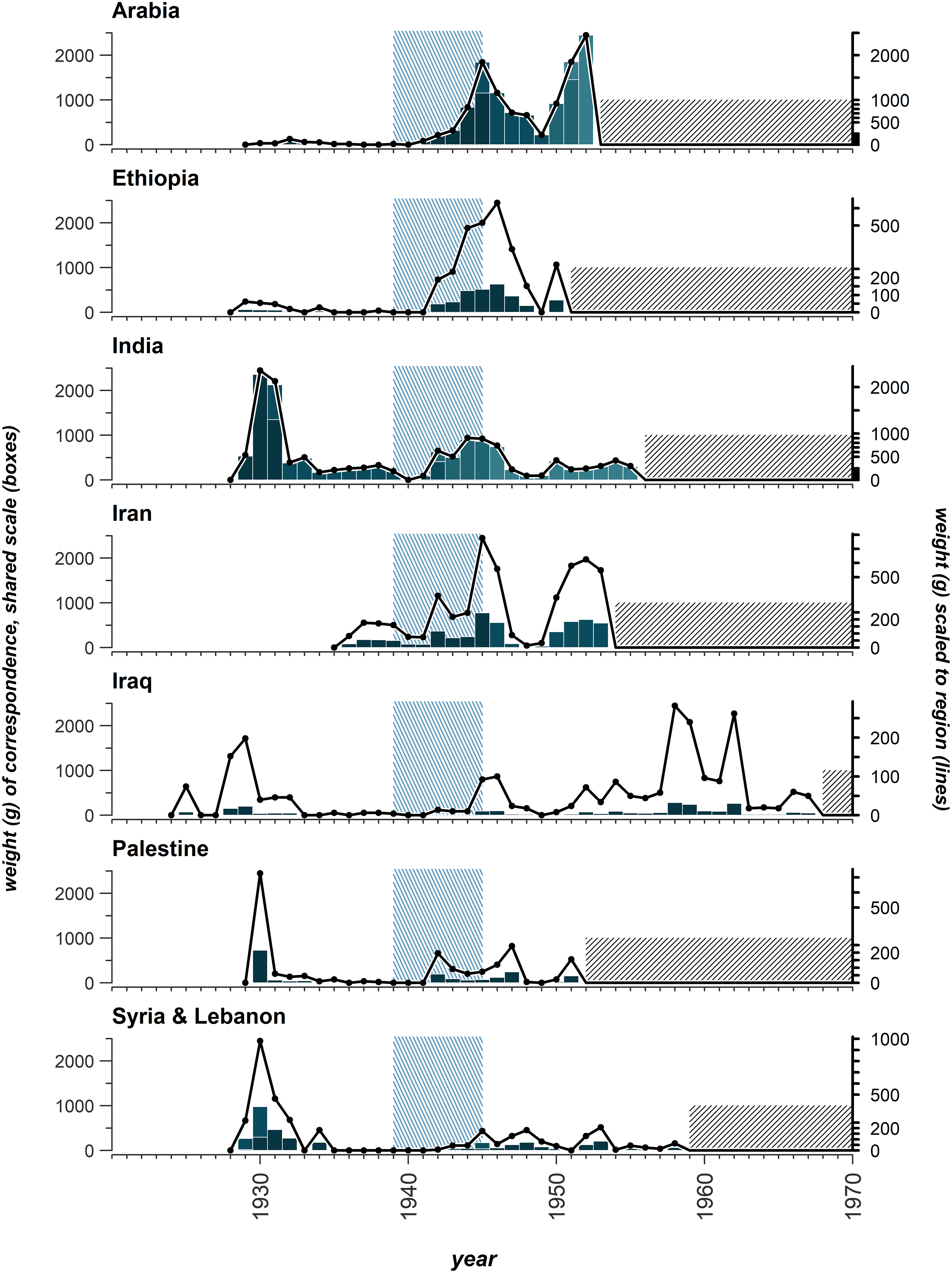
The accumulation of correspondence to the Anti-Locust Research Centre (ALRC) for seven regions, recorded as weight (in grams) by year. The data is shown on two scales. The black line, right axis, show weights for each individual region. The boxes, left axis, are on a shared scale, relative to Arabia. The box graph is stacked to indicate where correspondence is stored in multiple boxes. The green colour links to the archive box colour. The war period 1939–1945 is shown as a green hashed area. Weights were not recorded for the hashed region ending each plot.
The first is that ALRC correspondence was by no means distributed evenly across time and space. Certain countries (for that is how the reports were filed), each constituting particular data terrains, loomed larger in the information territory than others. The second is that there are sufficient indications that this variation cannot be explained exclusively as a function of locust biogeography or recession-plague dynamics (that is, either ‘locust space’ or ‘locust time’). Instead, this indicates the power of the assumptions that brought the information territory into existence, which, as Elden (2013) has demonstrated with reference to territory, were as much about imaginings and culture as they were new technologies of surveying and statecraft, and which, again, we can follow up with closer archival work. Four key assumptions hide behind the peaks and troughs of correspondence in Figure 3 beyond locust activity itself, reminding us that the ALRC information territory was far from neutral, and played a critical role in determining how resources were allocated, and activities conducted.
The first is about the supposed value of information and space, and is best illustrated by the centrality afforded to certain regions within the overall control scheme long before data existed to substantiate such an argument. This was especially true of Saudi Arabia and Ethiopia: two countries which were both unusual in having resisted the advance of European colonialism in their respective regions (at least until the Italian occupation of Ethiopia in 1935), and which both became the focus of intense European speculation about the potentialities and ‘mystique’ of their relatively inaccessible interiors. Thus it was only in 1943, once the ‘special mission’ specifically designed and resourced to build a locust reporting network in the country from scratch was underway, that Uvarov finally had data to test ‘the supposition’ that Ethiopia formed the crucial interface zone between a northern and eastern locust breeding ‘system’. The Italian occupation and subsequent breakdown of communication with this ‘enemy territory’ in the early war years had only made it a more tantalising prospect: these culturally-driven assumptions shaped ALRC efforts to pressure local authorities into securing access. 25
The second is about informational value and race: reporting on certain territories was slow to take off until the ALRC was satisfied that white European (and preferably British) authorities were on location to produce or verify the information relayed to the Centre. Despite the increased likelihood of them actually encountering Schistocerca gregaria, nomads such as the Bedouin were seen as particularly unreliable informants. Wartime instructions on the ‘organisation of locust control’, for example, wrote disparagingly of ‘nomad areas’ where ‘people might not know (or care) sufficiently’ about locusts to be useful. 26 Even in the 1950s Uvarov was still advising the Desert Locust Survey (which was running local training courses in locust observation and control in Asmara) to water down the instruction so as to reduce the possibility of trainees making their own assessments, or indeed of thinking for themselves. ‘By describing to them eg the phase characteristics, or the diurnal regime, etc’, he wrote in 1951, ‘you may easily get them to imagine that they know what to expect and what to put in the reports’. This was ‘particularly dangerous’, he warned: these were only ‘semi-educated men’. 27
In this way, the information territory was working to shut out different cultural and informational traditions about the locust, while arrogating unto itself all right to conduct analysis (from London); it policed the line between data, information, recommendation, and action. A third assumption, then, was about the supposed value of information and its place within the ALRC information hierarchy. It was only through the strict centralisation of data gathering that the locust problem in any given area could effectively be seen. Planning for a future ‘International Desert Locust Security Service’ in 1945 (and based on supposed ‘best practice’ pioneered during the war), Uvarov dreamed of 27 separate jurisdictions all passing their reports to a unitary Head Office to be summarised and analysed: ‘only in this way will it be possible to see …’. Anticipating ‘friction’ if countries with ‘efficient national organisations’ were permitted to control their own outbreaks, he instead favoured a ‘unified international control’ operating everywhere. (The scheme was not adopted). 28 Sometimes, ALRC locust information was explicitly forbidden from being shared with individual countries: indeed, ‘a great deal of the information’ referring to and generated by military anti-locust campaigns in East Africa and the Middle East was classified as ‘secret’. 29 More broadly, the quantification of locust data served as ‘a technology of distance’ (Porter, 1995), compounding its centralisation and the exclusion of alternate interpretations. As Kennedy and Hill (2018) observe, ‘in datafied times, it is not only numbers, but also the feeling of numbers that is important’.
Fourthly, Figure 3 reveals the importance of war in the ALRC information system. This goes beyond the apparent coincidence of the 1942–1948 plague with military conflict and occupation across East Africa and the Middle East. In some of his publications, Uvarov claimed that the Second World War had upset his hopes for tighter international locust control, and it is true that the coming of the war could devastate reporting arrangements in some theatres. 30 In the Middle East and East Africa, however, it was the making of them. Here, the presence of British and imperial armies directly affected the volume of information to ALRC – the coming of the war enabled unprecedented levels of observation and action – so that the ALRC's correspondence archive is as much a reflection of the British military state as it is the movements of locusts themselves. 31 The surge in reporting from Ethiopia in Figure 3, for example, tracks with the fortunes of the East African campaign rather than locust swarms per se. From the ALRC's perspective, this inward rush of resources was welcome, but it also suggests how the wider currents of war distorted the information territory: what it saw, calculated, and did. The creation of MEALU as a semi-autonomous force and Uvarov's ability to direct its movements alleviated some of this effect, but not fully. When, as in November 1944, military priorities directed the withdrawal of mechanised transport from the Middle East theatre, locust reporting in southern Arabia and Oman duly suffered. 32
The ALRC presented itself as an independent organisation, and its information territory as a space above politics, responding to and reflecting the biogeography of the locusts themselves. Behind its data flows, however, the information territory contained myriad proclivities and assumptions that affected what it saw and how it saw it. Nowhere would this be more manifest – or its implications for the smooth operation of the information system be more exposed – than in the vicissitudes of the ALRC's data terrains.
Spatial friction and temporal resistance: among the ALRC's data terrains
Terrain, as theorised by Elden, is where the geopolitical and geophysical meet. Its particularities, irregularities, and characteristics enable political, economic, strategic, and state projects, even as it is transformed by those projects in turn. In the same way, our information territory would have been nothing without its data terrains. Yet their realities also posed serious problems to the smooth operation of this information system, and familiarising ourselves with them must necessarily question many of the ALRC's own claims to its objectivity, efficiency, and capacity.
The ALRC may have taken the view that ‘since locusts do not recognize political frontiers, it would be useless to examine the problem on a narrow national basis’ (Roffey, 1970). But operating so seamlessly across locust space frequently proved impossible, contrary to Uvarov's effusive remarks that ‘the co-operation of the various countries concerned was obtained without difficulty, because their self-interests coincided with the common interest’ (Uvarov, 1943a). After 1932, for example, the government of the newly independent state of Iraq, freed from its obligations as a British mandate, ceased to submit locust reports to London with anything like the regularity Uvarov desired or expected. 33 In Ethiopia, the British officer in charge of the ‘Special Locust Mission’, David R. Buxton, warned London that the development of a reporting network would be delayed, possibly for years, by ‘the general absence of communications and very scanty telegraphic services’. Nor was this purely a matter of physical infrastructure: Buxton wrestled with how to overcome a reluctance of tribesmen to, as he put it, travel outside their home territory, for while ‘some routes are in fact dangerous’, all were ‘believed to be so’, greatly hampering his attempts at locust investigation. (‘It is necessary, in this country, to adapt oneself to continual frustration’, he wrote to Uvarov). 34 Thus a single data point which might have taken Zena Waloff a matter of minutes to plot in London may have taken an officer on the ground, like Buxton, several weeks to create. Sometimes, access was simply impossible. In the winter of 1943, Buxton could not reconnoitre along the direct road from Addis Ababa through southern Ethiopia ‘owing to serious disturbances in that part of the country’. At Adagalla, where numerous bands of hoppers had been reported, he was unable to set up camp ‘owing to the hostile attitude of the local Somali population, upon whom one is dependent for precise news of hopper distribution, as well as for animal transport’. Buxton even marked out an ‘Area which cannot be dealt with owing to insecurity’ on his own annotated map of his attempts to gather information in Ethiopia – an altogether more cautious and uncertain visualisation of anti-locust work from that conveyed by Figure 2 above. 35
‘Ethiopia required special treatment’, Uvarov conceded (1943a), but these problems were much more widespread. In 1942, the Governor of Aden warned that ‘large areas of the Protectorate are not under effective control’ and would only permit anti-locust work ‘where cooperation of chiefs is likely’. 36 Indeed, the mere anticipation of political and logistical difficulty was enough to constrain the Arabian locust campaign the following winter. 37 Yemeni authorities refused British requests to assist in locust destruction in the Beidha Province, so that ‘the necessary early intelligence of any group of locusts reaching the incipient swarming stage could not … be obtained’. 38 The MEALU Confidential Report for the first quarter of 1945 accepted that shortages and obstruction had forced the Unit to operate ‘in cultivated areas only, while leaving desert areas uncontrolled’, and that there were whole areas where ‘even visits for the purpose of issuing warning reports have not always been frequent or, in some cases, even possible’, resulting in crop damage, especially in eastern Arabia and Oman. 39
All this, it is worth remembering, was happening at the very height of the ALRC's powers. In Figure 4, we have sought to show how even locust data for a country of prime interest such as Saudi Arabia was often collected from locations beyond its borders, or right at its spatial limits. We show this by plotting the reports within the ‘Arabia’ boxes against the locations from which they were actually sent. While direct reporting certainly intensified between 1943 and 1946, it still tended to favour nodes and pathways with a longer history of communication with the London Centre. As decolonisation progressed, however, growing numbers of countries were reluctant to cooperate with a British organisation whose relationship with colonialism was not as obscured as Uvarov sometimes suggested. In private remarks to the Colonial Research Council in November 1952, he lamented the ‘gaps’ being created ‘by political interference in this purely scientific field, and by the difficulties put up by nomadic tribesmen’. 40 These gaps could not be filled, placing extra value on indirect, improvised reporting.
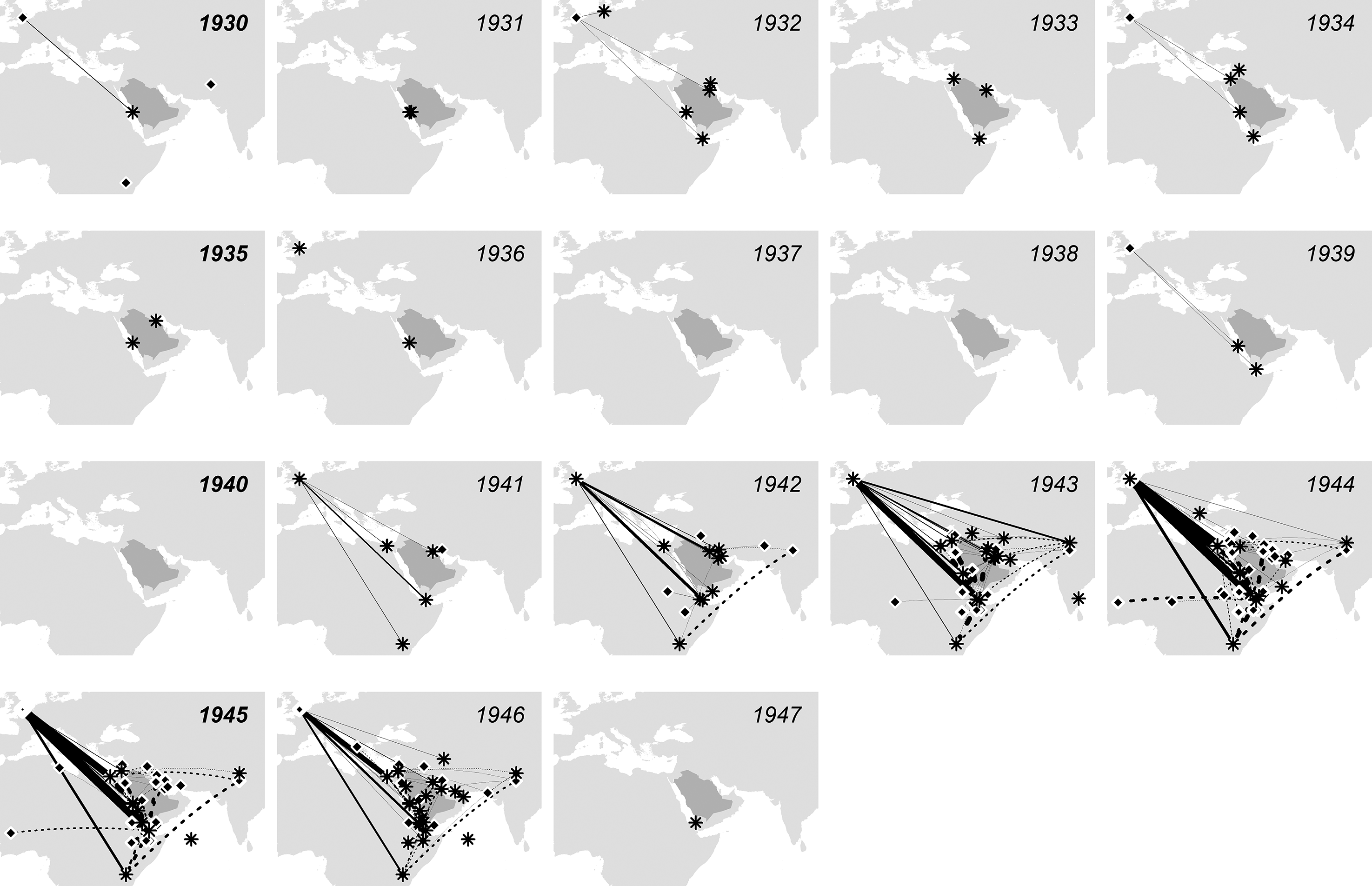
Origins and destinations of locust correspondence relating to Arabia for the period 1930–1947 inclusive. Stars indicate the origin of the correspondence and circles indicate the destination. Solid lines indicate correspondence directly sent to London, and dotted lines indicate correspondence sent elsewhere, but later forwarded to the Anti-Locust Research Centre (ALRC). Coordinates were not originally recorded in correspondences and were pieced together from historical records and contemporary maps. No data is shown when coordinates could not be reliably retrieved.
The range of locust migrations, the harsh environments in which they bred, and the logistical and political ‘friction of terrain’ that resulted all worked to frustrate the ALRC's ability to operate across locust space. But the ALRC information territory was not solely a matter of data collection; it also entailed the construction of a processing and communications system that was sufficiently fast that data could be turned into actionable information. Given the imperfection of any given model, whether built on expertise and opinion or otherwise, forecasts degrade when spatially and temporally dynamic phenomenon are recorded with delays. In our case, the movements and other behavioural responses of the locusts, and logistical, environmental, topological, and political barriers all resulted in a reduction in information value over time. Beyond the recession-plague dynamics of the locusts themselves, therefore, this was a further dimension of the problem of ‘locust time’. Data had to be sent, received, processed, and reported upon within time constraints; but that data followed a very different path, on different timescales, to that of the locusts. It had to be communicated from the location of an observation to London, and then back to the governing authority of the territory affected, probably via multiple political and administrative hubs along the way. While a desert locust swarm might fly up to 150 km a day, the communications about them covered much greater distances. If we can liken this to a game (and locust officers often did), it was less one of ‘cat and mouse’ (or a ‘chase’ after the locust) than of ‘battleships’, wherein information produced actions, from which more information was updated, and more bets were made. If the phenomenon was fast moving enough, then information would have a narrow window of relevance. A fast-moving game of battleships could last forever.
A pivotal moment in the ALRC's activities, therefore, came in the autumn of 1943 with the external dissemination of its first forecasts, in the form of ‘Bulletins’ and cabled messages. As the hub for data communications and from which information emanated, timeliness was at the core of London's claims to authority. ‘No country’, claimed Uvarov (1943b), ‘has been invaded without receiving a timely warning from the ALRC (…) based on exact and timely information’. Yet the archive contains indications of how our data terrains generated temporal resistance, too. In Figure 5, we compare the dates that locust reports were sent by the Ethiopia ‘Special Mission’ with the dates they were received by the London Centre. This allows us to assess the speed in data exchange, and to observe the many possible steps at which delay could be introduced, including the time window covered by the data (the first and last date of the events covered by the correspondence), the delay before it was sent and, where possible, and time spent in transit before it was received. We find that the majority of the correspondence was received more than 30 days after the first sighting it recorded, suggesting a picture of the ALRC studying events after the fact rather than engaged in dynamic action.
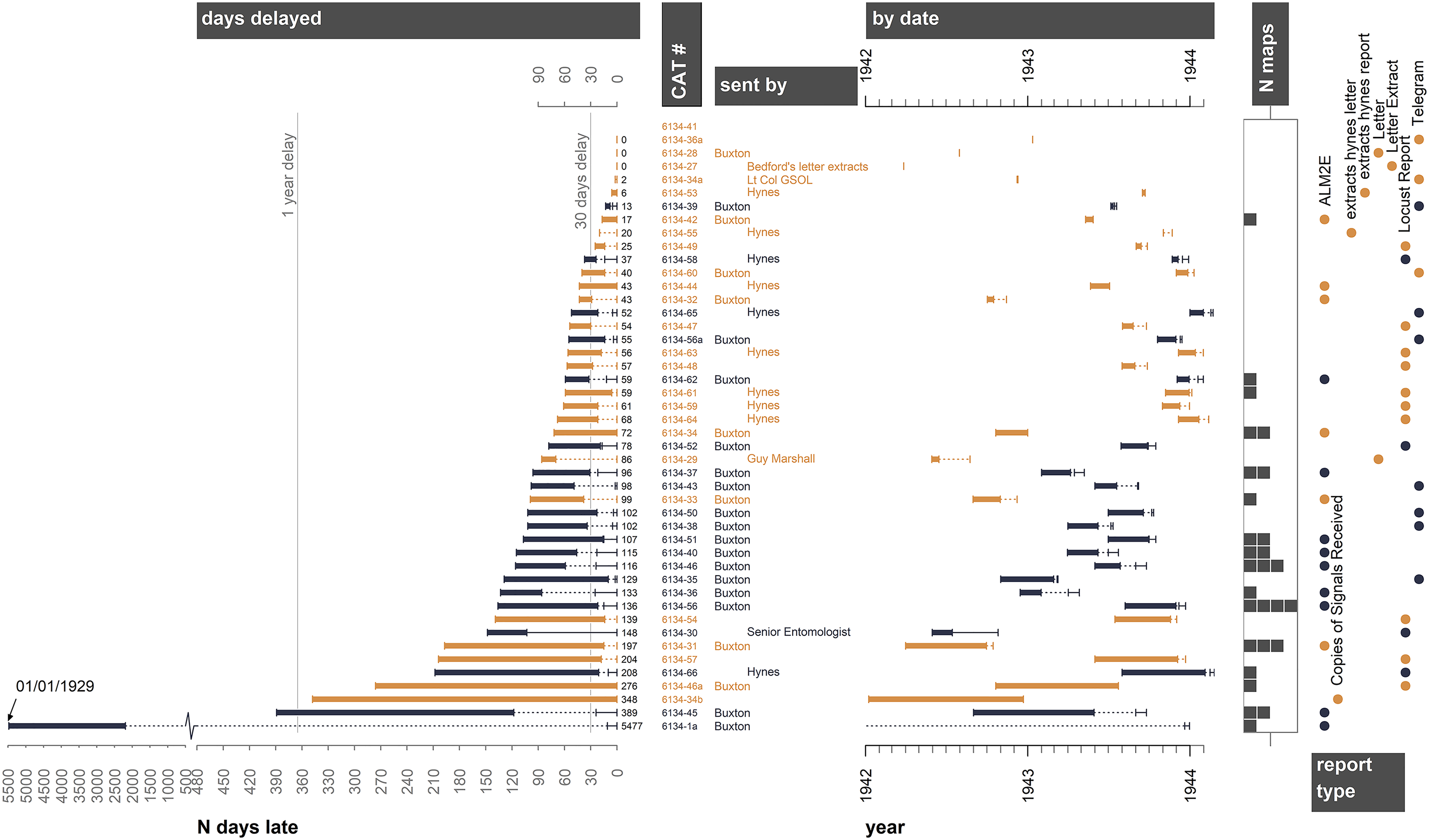
Delays and lags in the information system visualised for correspondence received from Ethiopia during the period 1942 to early 1944. The left-hand side plot shows the days elapsed from the date an item was received by the Anti-Locust Research Centre (ALRC) to the first report of locusts within that correspondence. Note that the time axis is broken as one correspondence contains a sighting in 1929 that was received 5477 days later. The bars show the data reporting period, the dotted line shows any time elapsed before the report was sent, and the solid line shows the sent and received dates, that is, transit time. Data shown in black includes all 4 dates (beginning and end of data, sent and received). Brown colours indicate that the date sent and/or received was not recorded (such as for telegrams). The catalogue number (cat #) is shown next to the sender's name, with Buxton, the locust officer, indicated by left alignment. The data are shown in real time in the right-hand plot. To the right the number of maps included in a correspondence are shown as grey blocks. The report type is indicated by dot symbols at the far right-hand side.
Such evidence of delay is further substantiated by written evidence within the archive. Breakdowns in the flow of locust information, including delay caused by the despatch of information to incorrect addressees, were not uncommon. 41 Upon returning from leave in February 1940, the British Senior Entomologist in Kenya failed to check the locust reports being produced by his Department of Agriculture for three months; when he finally did, as he confessed to London another month later, he ‘felt uneasy with regard to the position within our own territory’. 42 Delays could equally result from communications coming out of the London Centre. Some administrative and political authorities had difficulty interpreting how the ALRC represented its data visually, despite early attempts to standardise a set of map symbols for locust activity. One Colonial Office hand found an ALRC Bulletin map ‘a little difficult to understand … [It] has on it a number of black circles scattered all over the area including Tanganyika, Sudan, and as far as India’. ‘I should be glad to know what these black circles indicate’, he wrote. (They were towns). 43 In October 1942, Zena Waloff in London sent David Buxton in Ethiopia copies of all locust reports on file for Ethiopia to date, including her tentative ‘scheme of seasonal movements of locusts in East Africa’ built on careful analysis of information from the previous outbreak. This was probably very valuable, Buxton replied some five months later, but he was so busy wrestling with getting his own information service off the ground that he ‘scarcely had time’ to study it. 44 Indeed, finding it ‘difficult to arouse real interest in the affairs of locusts in official quarters’ in Ethiopia, Buxton doubted if it would ever be possible ‘to obtain prompt or frequent reports’ from the country. 45 It was, he told Uvarov privately a few days later, ‘rather a poor return for the efforts and tribulations involved’. 46
But it was in forecasting that the ALRC's timeliness was most important. A central goal of the entire organisation was to forecast the future dynamics of the desert locust to better direct control operations. In practice, however, and as Figure 6 reveals, the ALRC experimented with a series of communication methods as it attempted to meet this goal. The first of these – the ‘Summaries’ – were actually intended for the edification and improvement of the ALRC itself. They documented and summarised vast amounts of locust activity across multiple years, at a stage in operations when the priority remained locating the desert locust's suspected breeding grounds. The first Summary, composed by Zena Waloff, covered 1937–1941 but was only circulated in May 1942, and to a limited distribution of trusted ALRC collaborators. Only later were forecasts afforded wider circulation, first in the form of printed ‘Bulletins’, then through cabled forecasts, and followed by monthly ‘Locust Situation Reports and Forecasts’.
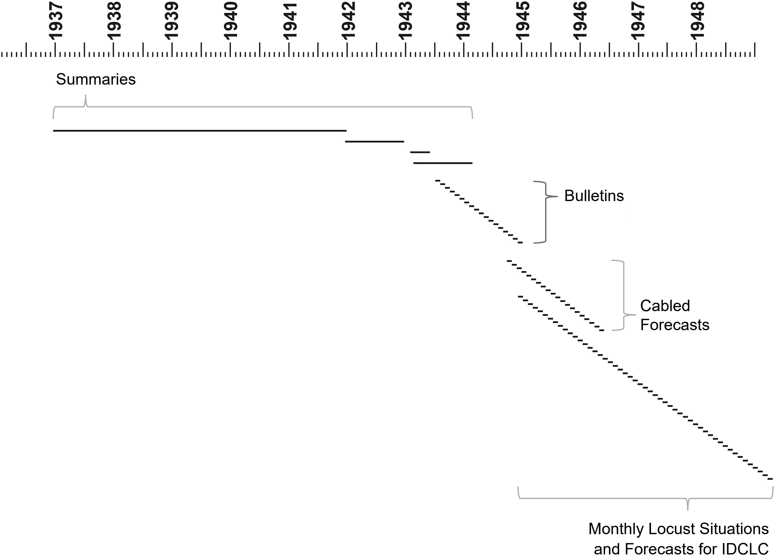
A timeline diagram showing the changes in frequency of reporting as the Anti-Locust Research Centre (ALRC) developed different kinds of reports. Initial summaries covered long periods, with monthly summaries being upstaged by monthly Bulletins, and then faster cabled forecasts, alongside slower monthly situation reports.
We believe the first anti-locust ‘Bulletin’ was based on data gathered partly by cable in July and August 1943, and sent, on 22 September, as 38 copies for distribution through the Colonial Office, with another copy to the Foreign Office for wider circulation. This was a moment in which the tempo of information production within ALRC changed dramatically. Even so, its appearance came some eight months after Uvarov's bold claims about forecasting referenced above (1943a, 1943b). As Figure 6 shows, it was a further full year before the ALRC issued its first cabled forecasts (the first being a telegram to O.B. Lean, then Chief Locust Officer in the Middle East). These naturally constituted a substantial improvement in the speed of transmission to targeted recipients within a broadening but still closed circle of ALRC colleagues.
All this is important because the entire enterprise of locust reporting and its data was ostensibly crucial in the planning of control operations, but the degree to which it was actually used remains unclear. In his final report on the MEALU campaign in Arabia for 1943–1944, Vesey-Fitzgerald noted how often ‘faulty early forecasting’ had led to anti-locust detachments concentrating in the wrong place. 47 A rare private comment from Uvarov on that first Bulletin is also suggestive. Asking David Buxton in Ethiopia for his ‘frank criticism and suggestions for improvement’, Uvarov claimed the Bulletin forecasts were ‘intended mainly to provoke people into trying to catch us out, and thus make them interested in comparing the actual events with the forecast’. 48 That may have been a tongue-in-cheek remark, but it affords a very different depiction of the forecasts’ function and predictive power from that which Uvarov and the ALRC repeatedly claimed in public.
Even when data could be communicated, processed, analysed, and relayed in time to be actionable, individual governments and regional authorities – even those under British colonial rule – were under no compulsion to follow ALRC guidance. Despite the pivotal importance of forecasting to the very rationale of the ALRC, we have discovered few efforts to critically evaluate their accuracy in light of subsequent locust dynamics. Crucially, the forecasts’ materiality as determined by the data terrain – which may define its uncertainty, relevance, reliability, or precision, amongst other critical qualities – was rarely communicated alongside the forecasts themselves. A key terrain within the information territory, therefore, may have been that of belief itself.
Conclusion: a science-policy interface from the age of empire
Narratives around the ALRC often focus on the historic destruction that locusts have wrought on humankind, and the foresight and fortitude of Boris Uvarov. Yet the story of the ALRC is much more multifaceted. In this paper we have sought to offer a preliminary analysis of the archive it left behind, and a reflection on how our own interdisciplinary approaches were shaped by its provocations.
First, we find that there is much to be gained by approaching the ALRC in terms of the creation of an information territory and its work among data terrains. Viewed in this way, the ALRC becomes an organisation that was attempting to construct an information infrastructure with the speed to understand and respond to locust biogeography. Conventional narratives of the ALRC tend to describe it as an information processing unit that acquired data on locust distributions to inform its reports and maps. We find that such simple models of ‘data in, information out’ are only partially true, for they overlook the structures underlying a system that was evolving across our study period, and which was operating through pen and paper, telegraphy, postal systems, and radio. In this respect, our ecology of information approach, as something of a spatio-temporal audit, resonates with the work of Stoler and Cooper (1997) in that it ‘ask[s] harder questions about how official accounts were produced, transmitted, classified and stored’, and also with that of Braun (2024) in revealing the ‘incremental and opportunistic approach to mapping’ behind the ALRC's information territory. Thinking with a concept of an ecology of information enables contrasting perspectives by connecting data terrains to the information territory, and a more nuanced analysis of the distribution and abundance of data in relation to the information and knowledge claims trumpeted by the ALRC.
This approach also helps to reveal important aspects of the interactions, conditions, and actors that determined the distribution and abundance of data, and the transformation and flux of data and printed matter, whose relationships with information are again crucially important. Exploring the structure of information within the ALRC archive offers glimpses into a web of uncertainty and error, delay and feedback otherwise masked by the Centre's own pronouncements and the sheer difficulty of external reviewers holding its processes to account. Indeed, we find that the spatial structure and temporal dynamics of the ALRC information system were just as important to understanding its activity as the behaviour and life cycle of the desert locust – if not more so. Bringing an analysis inspired by ecological surveying into dialogue with one built on historical analysis of the ALRC's documentary record has revealed a system that was altogether more contingent, opportunistic, uncertain, fraught, and indeed, more interesting than the ALRC's own in-house histories suggest.
Secondly, thinking about the ALRC as an information territory – a political technology producing coarse-scaled analysis and comfortable operating in a rhetorical space – gets to the heart of its relationship with epistemic and political power: aspects of its history downplayed in many existing accounts, but which seem to us critical to understanding that history in context. One way to think about this is to assess the ALRC as a Science-Policy Interface (SPI) through attributes relevant to science-policy today, namely credibility, legitimacy, and relevance (Heink et al., 2015). The ALRC's information territory may have been its public face, but its relevance or credibility in terms of locust dynamics, or even anti-locust operations, was questionable – and certainly lower than the store set by it in public discussions of the ALRC's value and role, both at the time and since.
Viewed in this way, the ALRC's information territory conferred many advantages, but we must consider chief among them its capacity to leverage the ‘war on locusts’ into a form of ‘British expertise’ which, in an age of global war and emergent anti-colonialism, proved a boon to Britain's flagging reputation in Africa and the Middle East. In a sense, the information territory served to not merely turn data into information, but into yet another valuable resource: rhetoric. In lieu of outside bodies capable of assessing its work, questions over the credibility, legitimacy, and relevance of the ALRC were addressed through the rhetoric it projected. The establishment of an information territory was foundational to this: it exceeded the realities of the data and its uncertainties. The ALRC information territory presented a narrative of locust dynamics within Uvarov's vision for the organisation, but it did so amidst a general context of colonial mapping projects, including (as noted by Braun, 2015) their many improvised practices, often carried out with threadbare staff or resources. Understanding this context is crucial to assessing ALRC claims to knowledge or capacity, and to reading all the materials it produced, including its archive. Campaigns needed maps (Collier, 2015), and campaigns needed resources. In this organisation's formative years (whilst its processes and sources were developing), a better descriptor than the prevailing ‘data in, information out’ model, would be one of ‘partiality in, completeness out’, as the ALRC explored how to harmonise data from multiple, distant, and heterogeneous sources and times, into outputs that could influence diverse audiences and stakeholders. To some extent, rhetoric protected the status and resourcing of the information territory.
In turn, communicating with the information territory expanded the ALRC's capacities. In the contexts of late colonialism, global conflict, and the early Cold War, doing so necessarily assumed political consequence. Indeed, thinking about the ALRC in this way offers striking parallels with current discourse around ‘British leadership in the fight against climate change’: then, as now, British ‘expertise’ in a given field was leveraged to boost the British brand at a time of global relative decline.
This leads to a third conclusion, about the potential of using the imperial past to provoke questions of science-policy interfaces in our global present. Science and colonialism have a long and storied relationship, of course, but the ALRC's aspirations to operate on a worldwide scale makes for a particularly rich subject in this regard. Hailed as a success by so many influential participants and observers, it was perhaps the prototypical international science-policy interface of the first half of the twentieth century. 49 Two points leap out to us. First, we recognise the enormous enterprise that international science-policy can be, and understand the information territory as having close links to science. But the information territory was also a key boundary object, constituted partly outside of ‘science’. As Beck et al. (2014) have written, international politics can strongly influence how scientific assessment bodies form and function. The ALRC story allows us to explore how those pressures have developed and played out over time. Secondly, the ALRC story is a powerful reminder of the problems that follow when such enterprises fail to open up sufficiently to recognise ‘multiple knowledges or diverse standards of evaluation’, including addressing ‘the reality of uncertainties, political antagonisms, and power struggles’ that inform their work (Beck et al., 2014).
Shining a light on the conditions among which the ALRC's data practices operated provides important qualifications to its scientific work. For example (and inspired by Reid and Sieber, 2020): given that archival records and correspondence were received from varied, shifting, and ad hoc sources, it would be unlikely that they would represent a singular, coherent ontology. Expansion of the scale and extent of the ALRC's operations broadened the diversity of the spatial, empirical and cultural ontologies on which it depended; and that inevitably extended the scale of trimming, reshaping, or collapsing of ontologies in producing a single archive. As we have noted above, the ALRC were selective about whether local inhabitants’ voices were expressed in the record, despite locusts being part of their lives and their terrain for millennia. From this position, the ALRC's information territory seems further detached, as the data they might report became a kind of information product for which there was negligible scope for community or public re-use: information, as ALRC property, was deployed in defence of ALRC authority. Together with its archive, it became a communication device constructed for what Martin Bauer (2008) has referred to as ‘knowledge marketing’. By the later 1940s this was already taking a toll on the willingness of publics across Africa and Asia – outside London – to listen.
Ultimately, all science-policy interfaces are historically contingent and home to assumptions that affect their work and utility. Yet it is rare to get glimpses into their inner workings in real-time, and this is where historical analysis can be instructive. Systems for producing and maintaining the ALRC's expertise were neither fully formed when its forerunner was established in 1929, nor available off the shelf through investments of time and money. Theirs was also a risky undertaking, absorbing significant resources, placing bets across time and space, and with the potential food security of communities across Africa and southwest Asia on the line. Little wonder, then, that the ALRC did not immediately produce a system of quantification that was – in the parlance of today's SPIs – ‘rigorous, defensible, and enduring’, and instead exhibited a certain defensiveness and a tendency to evangelise about its achievements. Compared with the contemporary science-policy juggernauts such as the IPCC and IPBES, however, the ALRC grew outwards from a science that had significant applied relevance from the outset. It did not draw a line between accumulating the best of knowledge and its influence on policy: data collection, basic science, scientific synthesis, pest control, political advice, international development, logistics, technological advancement, and informal diplomacy – even military strategy – were all entangled in its ongoing and evolving activities. Historical study can ‘illuminate the constraints on contemporary policy’ (Divall, 1993), but also, by way of contrast, its real achievements. There is plenty of reason to return to this forgotten archive yet.
Footnotes
Acknowledgements
This paper draws on a wider examination of the ALRC archive dating back to 2016. The original research was funded in part by two awards from the UK Arts & Humanities Research Council (AHRC) Science in Culture scheme (AH/N007085/1 & AH/R004633/1), and we thank our collaborators on those projects, Amanda Thomson and Katherine Brown, and institutional support from the Natural History Museum, the National Museum of Wales, and the United Nations Food and Agricultural Organisation's “Locust Watch”. For the purpose of open access, the author(s) has applied a Creative Commons Attribution (CC BY) licence to any Author Accepted Manuscript version arising.
Funding
The authors disclosed receipt of the following financial support for the research, authorship, and/or publication of this article: This work was supported by the Arts and Humanities Research Council (grant number AH/N007085/1, AH/R004633/1).
Declaration of conflicting interests
The authors declared no potential conflicts of interest with respect to the research, authorship, and/or publication of this article.