
Abstract
The increasing use and integration of space technologies in International Development projects raises fundamental questions about the ways in which these technologies are produced and applied, for what purposes and what ideas of innovation underpin their knowledge frameworks. With reference to two UK Space Agency (UKSA)-funded projects aiming to create an environmental information system using remotely sensed data, this article considers the possibilities and threats of user-centred technology design for the management of Indigenous territories. The team of Indigenous and non-Indigenous researchers grapples with the contradictions and sites of tension emerging at the intersection of the space sector, development, Earth system science and Indigenous sovereignty. Can space science and development be re-interpreted in the light of local needs, knowledges and right to self-determination? While common reliance on Western epistemologies feeds into deterministic understandings of technological benefits, this article presents Indigenous worldviews and practices as integral to codesign and co-implementation of innovations that are both technical and social. It argues that data are grounded and must be kept in connection with the contexts, culture and knowledges that make up a place. Praxis – as a theoretically inspired practice of doing development projects – thus emerges as a worldmaking activity inspired by a vision of design that foregrounds Indigenous sovereignty.
Introduction
The ubiquity of space-enabled technologies, such as satellite communication, navigation and remote sensing, and their impact upon human activities has reframed outer space as contiguous and entangled with Earth (MacDonald, 2007). 1 The role of remotely sensed data is often hailed as fundamental for the monitoring of climate change and its effects, such as deforestation and flooding. The harnessing of benefits of space technologies on Earth has motivated new funding streams promoting the use of environmental monitoring for international development. In the United Kingdom, the International Partnership Programme (IPP), funded jointly by the UKSA and the Foreign and Commonwealth Development Office, aimed to “fund space-related projects that improve people’s lives in developing countries”. 2 A significant number of projects under this scheme used Earth Observation as a tool for monitoring forest and coastal change, and to inform risk models in areas ranging from disease control to disaster management. The IPP made use of development buzzwords, such as local participation and co-production (Cornwall, 2007), to suggest that embedding user-centred design in the delivery of space-enabled innovation and increasing the use of satellite data in the Global South will support achieving the United Nation’s Sustainable Development Goals. However, as Ramesh Srinivasan shows in Whose Global Village? (2019), Indigenous knowledges and worldviews, which have been threatened with extinction by centuries of colonialism, are often erased in the creation and implementation of sociotechnical systems, even when participatory design processes are used or advocated for. For this reason, given the persistence of colonial power inequalities and development’s ‘technocratic turn’ (its increasing demands for technical expertise, see Greenwood, 2020; Read et al., 2016), the power to see, connect and interpret data from space enabled technologies need to be critically analysed in the context of the asymmetries that constitute international development as a discourse and a method of control over the Global South (Escobar, 1995).
In this article, a team of Indigenous and non-Indigenous researchers presents a collective journey through the discovery phase of an IPP-funded project called DETECT (Integrated Space Technology Vector Control), which ran between 1 August 2020 to 31 March 2021, and a spinoff project called SMART (Landscape Sensor-based Monitoring Assessment using Remote Technologies) active from 1 August 2021 to 31 March 2022. The projects carried out within Indigenous communities of the North Rupununi in Guyana proposed to combine satellite data with other mapping information into an environmental information system to be used by the partnering communities for monitoring the health and status of the extensive wetlands within which these communities live and make a livelihood. The possible applications of this system range from flood monitoring to vector control (in this case, the surveillance and management of mosquitoes that are vectors of diseases). 3
Inspired by post-development thinker Arturo Escobar’s statement that “the entry of design into development is both troublesome and hopeful” (Escobar, 2018: 60), this contribution investigates how to attempt to create pluriversal technologies. These are here defined as technologies emerging out of collective processes of design led by Indigenous communities, which can foster forms of postcolonial resistance. Pluriversality stands for the possibility to deconstruct the universality of Eurocentric knowledge and open up the world to a plurality of views which have been historically subjugated. Design can help build a world where many worlds fit (Escobar, 2018: 21) Pluriversal processes of design must privilege “localization, self-organization, and a collaborative social praxis” (p. 163). Collaborative social praxis as the theoretically-inspired practice of doing development projects together, and collectively creating new ways of living and thinking, is thus at the heart of this examination of the troubles of bridging space and development and of the hopes for more just partnerships in research and innovation.
The discussion of the work undertaken to integrate satellite data within environmental monitoring systems co-designed with Indigenous researchers expands the literature on the use of digital environmental monitoring for protecting and managing Indigenous territories (Cummings et al., 2017; Paneque-Gálvez et al., 2017; Tilley, 2020). It also adds to the burgeoning field of critical remote sensing by examining “alternative sociotechnical and geospatial practices” (Bennett et al., 2022: 743) within the disciplining apparatus of development projects. Moving away from the deficiency model of development, which sees lack of innovation within communities as an obstacle to development, this article de-emphasises the importance of new technological objects as project outputs, and focuses on critical and creative processes that underpin innovation, and on their potential to generate new dialogues and forms of solidarity. It approaches technology design and research methods as battlegrounds for resisting the universalist logics of development and innovation.
The article starts by describing the approach taken to propose a community-led form of innovation. It then focuses on the collective journey that saw the emergence of different methods used to pluralize understandings of and plans for future-oriented technologies. These included community consultations, interviews and surveys, creative exercises such as drawing and oral storytelling, as well as reflections shared during and after discussions and workshops. 4 It then highlights that it is necessary to shift discussions about the use of space-enabled technologies and data in marginalised and oppressed communities away from an emphasis on inclusion, which constrains the ambition of development interventions, and to embrace the importance of foregrounding community sovereignty. As Bennett et al. summarise, critical remote sensing is well-placed to “foster discussions surrounding Indigenous self-determination and sovereignty over their epistemologies, knowledge and information systems, and data” (Bennett et al., 2022: 741). This article fills a gap in the literature by presenting our collective journey through two connected projects, presented in more detail in the section below, which aimed to prioritise Indigenous sovereignty in research and innovation activities involving remote sensing technologies.
DETECT and SMART: decentralising monitoring through pluriversal design
DETECT and SMART built upon 20 years of partnership between UK-based and Guyana-based researchers, Indigenous associations and communities of the North Rupununi (Berardi et al., 2017; Mistry et al., 2014, 2015, 2016). The full team of these projects comprised over 40 individuals from 10 organisations, including research institutions, non-governmental organizations (NGOs) and commercial partners, in three different countries (Guyana, Scotland and Sri Lanka). However, the authors of this article make up a subgroup who actively engaged with exploring the intersection of the space sector, development, Earth system science and Indigenous sovereignty within Guyana. All the authors associated with the North Rupununi District Development Board and Caiman House are Indigenous researchers of Makushi and Wapishana communities – hence they were both part of the team and system users. 5
Our collective story of entanglement with the space sector started with DETECT, which was competitively awarded funds from the UK under the IPP programme in 2020 and entered one year of consultation and preparation phase between team researchers and Indigenous community members. The first year was aimed at the co-design of a system for environmental monitoring, to be followed by a longer implementation phase of four years. Funds to the IPP were terminated abruptly in 2020, when the UK Government cut aid spending from a target of 0.7% of gross national income to 0.5%. The effects of this decision unravelled in 2021, when many funding schemes dedicated to international collaborations were significantly scaled down or axed. Our project was among the ones that lost funds. The team then applied and was awarded a grant from the Technology Development Programme of the UKSA to trial the designed system in situ. This project was called SMART, but it covered only one year of activities, so the original four year-long implementation phase had to be rethought as a short-term and pared down pilot. In particular, the pilot focused on creating and testing a user-friendly interface for communities to download and check satellite data on surface water distribution. The objective was for Indigenous people to inform local development plans and decisions on environmental management. As the two projects built on each other, here they will be treated as one.
Thirteen Indigenous researchers from Yupukari, Annai and satellite villages led on community consultations, co-design of the environmental monitoring system, the gathering of environmental data, and shaped plans for future collaborations. The system was first conceived as a tool contributing towards disease vector control measures. Satellite remote sensing can provide data on factors such as temperature, vegetation, and land cover, all informative in the presence of vectors such as mosquitoes and indicative of disease outbreak. Our project aimed to combine environmental data from satellite maps, drones and ground data, such as density of larvae in the water, to identify and monitor breeding locations of Anopheles mosquitoes, the vectors of malaria. Technically, our proposed monitoring tool used Synthetic Aperture Radar (SAR), a type of satellite imagery using radar waves to map the Earth’s surface. Differently from optical sensors that detect natural energy sources, SAR uses sensors that emit their own source of energy, and then records the returned information (backscatter) to create an image. SAR can penetrate through darkness and clouds, which makes it particularly useful for military and defence objectives, but also suitable to monitor tropical areas that are covered in clouds for long periods of the year. The main technical innovation of the project was to apply an algorithm able to compare images and highlight changes (change-detection algorithm) to surface water extent to accurately track shifts in environmental conditions. 6 Automated surface water maps were produced every 12 days, extracted from images emerging from the passage over the Rupununi region of Sentinel-1, a two-satellite constellation owned by the European Space Agency.
The sequence of system decision-support was co-designed in four phases: (1) the SAR analysis would provide near real-time surface water distribution at a region level; (2) this would enable more targeted drone surveys to assess the characteristics of waterbodies as potential mosquito breeding sites; (3) Indigenous community members would assess the imagery and combine this with their traditional knowledge to identify specific sites for water sampling; (4) Confirmed presence of high densities of mosquito larvae would then trigger biocontrol measures using Bacillus thuringiensis israelensis, which would exclusively kill the larvae without impacting other wildlife or people (Land et al., 2019). Also, the co-design and testing of the sequence successfully deployed the first three phases, but DETECT never trialled the use of biocontrol as it was unexpectedly terminated early. SMART focused on repurposing and further operationalising the environmental information system by creating new features that allow the seamless and rapid display of surface water maps derived from the SAR analysis and diversifying the range of participatory environmental data collected by Indigenous researchers beyond just mosquito larvae, to include other meaningful data for communities such as size, type and density of fish, in order to inform a wider range of environmental decision-support of interest to these communities.
In Guyana, 267,000 people (35% of the population) are within high malaria transmission (>1 case per 1000 population) regions. The incidence levels in specific areas of the hinterland are above many sub-Saharan African countries (Aerts et al., 2020). The Ministry of Public Health's National Malaria Programme Strategic Plan for 2020–2025 has among its objectives to move towards a more decentralised, regional approach to data gathering, capacity building and management of malaria. This objective is in line with existing calls for tailoring interventions to local contexts by engaging communities (Atkinson et al., 2011). A decentralised approach embraces traditional knowledge, understood as the knowledge, innovations and practices of Indigenous peoples often passed over generations and responsive to changes to the environment (Mistry et al., 2021). It also uses accessible technologies. 7 This participatory approach requires meaningful and trusting partnerships with community members and capacity-building for using appropriate, low-cost and accessible technologies, which government officials and medical professionals are rarely trained to deliver. In the case of DETECT and SMART, existing local partnerships and the availability of international funds enabled us to attempt this approach.
The DETECT/SMART projects started with opening up questions about the possibilities and limits of using space technologies as low-cost and accessible tools for community-led environmental management and vector control. But with the label of “space for development”, mandated methodologies, such as quantitative measures for evaluation, a strong emphasis on product development and the interest in scalable innovation and commercialisation quickly became obstacles to genuinely community-led process. The languages and skills necessary to fulfil the obligations of development bureaucracy and commercial interests required input from outside the communities. For this reason, the team had to openly explore some of the contradictions inherent within the promise that space-enabled tools and development funding from the Global North can be used to further community objectives in Indigenous territories. For example, it was debated if supporting Indigenous-led and owned solutions was compatible with the commercialisation of the tool as required by the funder.
The intersection between space science, development, and Earth system science (underpinning environmental monitoring and decision-support), with Indigenous sovereignty creates sites of tension. Scientific knowledge of botany or astronomy for navigation were tools of colonial control over the Earth’s land and seas (Ferdinand et al., 2022; McClellan III, 2010). This same knowledge underpins the fields of space science and environmental science, which have been criticised for their involvement in neocolonial processes of land appropriation (Davis, 2017; Redfield, 2002; Smiles, 2020) and their use in development (Escobar, 1995; Kothari et al., 2019). The legacies of these histories of oppression reverberate into the present through the marginalization of Indigenous knowledges and leadership in these fields of research and practice.
In face of the neocolonial expansion of processes of appropriation of land, knowledge, data, Indigenous sovereignty stands for the independent authority of a community to determine its own development trajectory while retaining control over its traditional territory. Sovereignty is a promise of prosperity and resurgence despite the injustice and violence perpetrated through colonialism and settler state formations (Coulthard, 2014). In the postcolonial context of this study, technology is discussed as a potential means to monitor ancestral territories and incorporate, rather than bypass, traditional cultural practices. Pluriversal technologies need to further Indigenous sovereignty: this means supporting Indigenous people’s rights to choose and curate data and content related to their own peoples, cultures and lands, as well as to decide if and when this is to be released publicly through their own interpretations and understandings.
Given the rise in use of space technologies within contemporary development, it is fair to ask: what are the possibilities of constructing pluriversal, rather than universal, technologies within the hard logics of neoliberal accumulation and extraction? Tackling the universalism of technologies (the belief that they have universal applicability) and their disassociation from cultural and social practices is a fundamental objective of participatory and decolonial-inspired design processes. Our projects see co-creation as a form of “doing-with”, a sympoiesis – as argued by philosopher Haraway (2016), which requires experimentation with different methodologies. Design theorist Ansari affirms: “any engagement with articulating a relation between decoloniality and design necessitates articulating the relation in terms both poietic and praxical” (in Schultz et al., 2018: 83). The chosen practices of collective co-creation here described are considered as gateways towards realising the worldmaking possibilities of design. However, discussing the possibility of pluriversal technologies requires dwelling first upon the big picture of the colonial entanglements between space technologies and development. Then, it means placing attention onto the interconnections between the design of these technologies, the socio-technical practices of their use, and the state and capitalist structures that underpin them.
Grounding the space ‘gaze’
Within development, the use of space technologies raises questions about the ways in which spin-off technologies are produced, for what purposes and what ideas of innovation underpin them. Morozov (2013) has called ‘solutionism’ the belief that engineering solutions, such as digital technologies, can fix problems that are long-term and structural in nature, such as poverty and inequality. With schemes such as IPP, the technical challenge of creating new space-enabled technologies is coupled with the aspiration of enabling transformative change in managing resources or the risk of diseases. However, rather than solutions, we saw technologies as possible tools to be created and deployed within spaces where overlapping authorities (state/local), contested territorial claims and histories of Indigenous dispossession and repression remain centre stage. These tools can enable or resist instances of dispossession and marginalization, but they are imbricated in neo-colonial and capitalist processes of accumulation of data that are feeding a ‘datafication’ of life and nature.
The power to see, capture data from, and map environments needs to be understood in relation to at least three questions: who owns the technology? What are the processes of data capture? And who owns the data? These questions are at the heart of processes of technology creation, and critical remote sensing should be sensitive to the (geo)politics involved in the production, use and analysis of satellite imagery. The use of space data within development appears to be integral to the ever-expanding capitalist capture and concentration of resources, information and knowledge (e.g. Goldstein, 2020; Li, 2007; Thatcher et al., 2016). Processes of ‘data extraction’ increasingly blur the boundaries between private and public ventures (Zuboff, 2019), and intensify and complicate divisions between high-income and low-income countries. Couldry and Mejias (2021) endorse the use of the term ‘data colonialism’ as a reference to the ‘capitalist accumulation by dispossession that colonizes and commodifies everyday life in ways previously impossible’ (p. 1). The asymmetrical extraction of value from participative processes of environmental monitoring, such as crop identification or mapping of coastal erosion, for example, relies on the constant surveillance of the natural world and life. This practice unmasks the reality of exploitation behind the supposedly emancipatory promises of technological solutionism.
Environmental surveillance often results from interlinked activities of remote and local data collection (and brings to the fore the issue of data sovereignty dealt with in the last section of this article). In the case of satellite data, communities are often asked to validate information on the ground to perfect the maps, or to collect additional data to complement them. During our projects, Indigenous researchers validated or refuted spatial information by travelling to specific locations and double-checking changes to the boundaries of water bodies, as well as measuring water depth and, if needed, the density of mosquito larvae in the water. They also 'augmented' the information within their own experiences, cultural understandings and interpretations of what determines lower or higher risks of malaria infections, such as return from seasonal migration to mining areas, etc. These activities are grouped together and expressed with the phrase ‘ground truthing’. However, rather than emphasising the existence of a single truth, ground truthing activities can be said to show that the veracity of mapping is enabled by people’s knowledges and experiences and that these truths literally make the scientific maps (Robbins, 2003). Truth does not simply reside in the algorithmic abstraction of the time-series algorithm produced by the UK-based researchers on the project. As Machen and Nost (2021) state: Directing and disciplining our attention, algorithmic abstractions give the appearance of a whole while obscuring exactly what is being discarded in the process. As well as losing the richness of temporal and historical context, this work of abstraction produces a claim to universalism that obscures the partiality and situatedness of knowledge claims. (Machen and Nost, 2021: 561)
In our projects, validating the algorithmic accuracy of the remote sensing analysis was dependent upon other situated knowledges of the Indigenous researchers. One of the researchers on the projects asked to map a supposedly flat area outside the village unexpectedly found an inaccessible mountainous zone and simply remarked: “your satellite is a liar!”. Remotely sensed data must be and are, in effect, grounded by the truths and the experiences of those who have resided in their landscape for generations. In other words, the information portrayed within satellite remote sensing analyses need to be verified and validated by those communities that are embedded within the environment subjected to this top-down ‘space gaze’. Localised perspectives may actively challenge the abstraction and universalism of the technological gaze. However, while doing so, these knowledges may also remain unacknowledged and effectively get subsumed in the finetuning of the algorithmic abstraction.
While the reach of digital technologies is increasing, associated processes of centralization and storage of information favour a narrow group of users: these could be private companies that carry out large-scale, profit-driven data collection, or in the case of open access data, users that have access to high computing abilities and reliable internet connections. Despite the fact that programs such as Google Earth are widely accessible and relatively lightweight, inequalities remain in the possibility to access and use remotely sensed data, and Indigenous researchers in our projects struggled with access to computing equipment and online access. These two conditions can outright exclude the communities that live where data collection takes place and often generate the data through participatory research. In development and humanitarian programmes, Read et al. (2016) highlight the one-way direction of information provision from local communities to the organisations that attempt to provide help via data technology: Although cloaked in the language of empowerment, data technology may be based on an ersatz participative logic in which local communities feed data into the machine but have little leverage on the design or deployment of the technology. (Read et al., 2016: 11)
During one of the workshops with Indigenous communities in December 2021, participants remarked that too often their tasks are limited to the generation of data, while control of access to data, data analysis and interpretation are separated and outsourced away from their ancestral places. One of the effects of this separation is the marginalization of Indigenous knowledge and cultural practices about their land in data processing and analysis, which can actively undermine Indigenous sovereignty.
Satellite data present this tension in extreme terms. The fact that such data are often publicly available allows researchers and other actors to access Indigenous territories remotely, without needing community permissions or ethical approvals, and without knowledge of Indigenous practices. In the critique of a paper by Aguiar and Martins (2020) , which used satellite imagery to detect anthropogenic fire distribution in Central Brazil, Welch et al. (2022) demonstrate that the decontextualised use of satellite maps, which excluded Indigenous participation in the “ground truthing” and in the analysis, led to erroneous and harmful claims about the unsustainability of resource use in Indigenous territories. A superficial remote sensing analysis of the frequency and extent of burning within Indigenous territory was labelled by researchers as excessive and harmful to the landscape, thus blaming Indigenous communities for damages to natural habitats. After outlining land borders and considering longer temporal intervals, Welch et al. (2022) demonstrated that former cattle ranches with pastures and hunters were to blame for habitat degradation, while Indigenous people were misconstrued as reckless burners. This type of analysis “risk(s) providing the anti-Indigenous cause with apparent evidence that Indigenous peoples are irresponsible caretakers of their lands and therefore undeserving of them” (p. 4). The same authors argue for ethnographic insight to support responsible research. That is certainly important, but it still assumes reliance on external observers of Indigenous territories. We maintain that better design and deployment of space technologies and improved analysis of data are dependent upon Indigenous leadership in these processes.
Design beyond inclusion
The IPP programme incorporated and promoted aspects of human-centred design, in which user participation in the creation of a technology guarantees the delivery of a solution to a problem. Bordering solutionism, this view implicitly “continues to feed and be fed by ideas of development and improvement of communities that need ‘help’” (Taboada et al., 2020: 147). This idea of help presupposes that on the singular path to development, some actors are deficient and need to be helped by various means including investment and technology transfers. In accordance with this deficit model, the lack of innovation is often blamed as an obstacle to social progress (Pfotenhauer et al., 2019). Instead, this article and the projects de-emphasise the object of design as the product of innovation and focus on the potential of the creative processes ignited by the co-design process to give rise to new dialogues, perspectives and forms of solidarity. This view acknowledges that participatory pathways towards design can be outcomes in themselves and can be conducive to new creative and justice-oriented processes. In our projects, the process of exploring tensions and possibilities, including imagining opportunities for the future, created new forms of sociality and agendas for Indigenous-led projects to come.
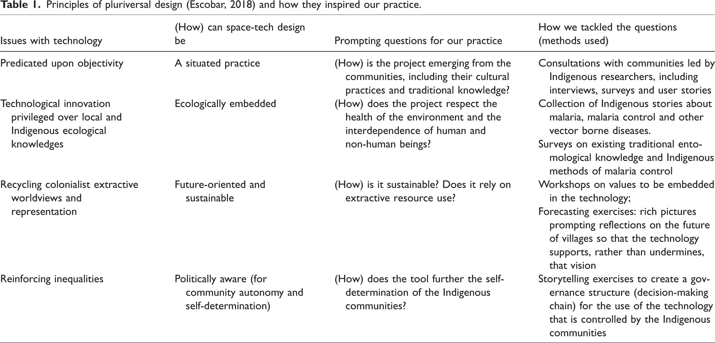
Table 1 summarizes some of the ways in which the design of technology can reproduce colonial forms of knowledge, as well as some of the alternative principles that have inspired our practice. In the third column, prompting questions supported collective discussions on how to imagine technologies differently. The last column summarises how we attempted to respond to these questions.
Principles of pluriversal design (Escobar, 2018) and how they inspired our practice.
To resist the impulse to rush into technological innovation, we started from the consideration that all communities practice forms of design, whether through the creation of tools, governance mechanisms, or community organization. For this reason, the whole consortium, and particularly non-Indigenous practitioners, had to start thinking beyond the expert/participant binary. This shift placed researchers in a position of co-designers, rather than actors at the centre of, or even directing the design process. Through the imagination of place-based solution in our projects, the localization of design actively resisted the impetus to create scalable solutions and focused on centering community objectives: autonomy, sovereignty, and self-determination.
In pursuing these objectives, weaving together Indigenous knowledges and other knowledges, including dominant science, became crucial. 8 Much design originating in the Global North tends “to ignore design epistemes that come from other places, cultures, or forms of practice” (Taboada et al., 2020: 146). Instead, a “decolonial approach must undermine stark oppositions that marginalize the subjectivities and epistemic traditions inferiorized by modernity” (in Schultz et al., 2018: 93). This means not only valuing and making room for dialogues between different knowledge systems, but also foregrounding Indigenous views of ‘benefits’ arising from technologies, as well as collecting and, where possible, collectively looking for answers to doubts and uncertainties. This leads to participative approaches that welcome dissent as a productive force.
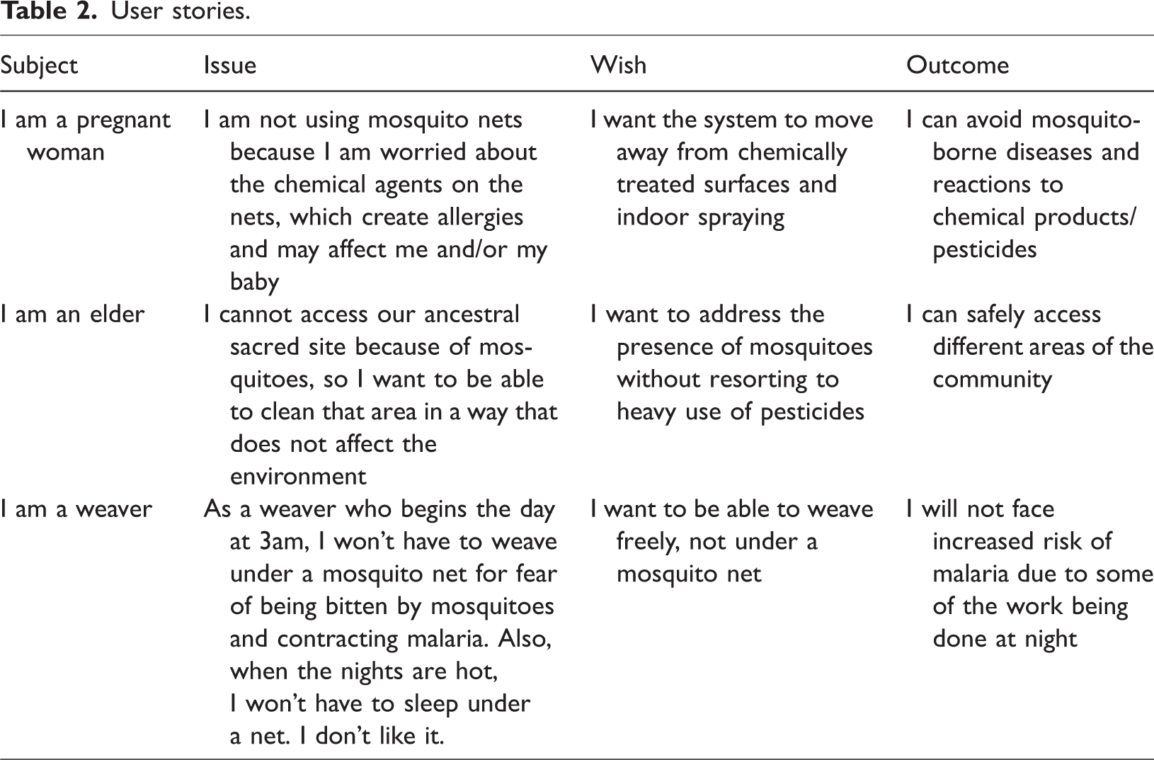
With this in mind, our design process tested the very utility of the proposed system. Stories were collected about the desirability of a locally operated tool for vector control. The responses emphasised the need to live with the environment differently, reducing the use of pesticides and recuperating cultural practices and traditions that changes to the climate have impeded. Some stories are summarised below.
These perspectives challenge a simplistic view of cultural traditions as opposed to technological innovation. While the environment changes due to ever increasing climatic disruptions, and existing malaria control measures are inadequate to address people’s needs, technological innovation, when qualified and directed by those communities requiring control intervention, can facilitate a closer alignment between Indigenous views of environmental and human health. Table 2 shows that resistance to the use of insecticide-treated mosquito nets, which are at the centre of the global and Guyanese government’s strategy for tackling malaria, relates to their perceived adverse effect both on human health and on productive activities. These resistances must be taken seriously in the design of interventions that put at their centre people’s health and well-being.
User stories.
Epistemologies and interconnections
It is crucial for justice-oriented practices of design to interrogate collective understandings of main terms, concepts and values. Health is a fundamental one. For this reason, our projects sought to centre the Makushi health epistemology and saw better health as emerging at the intersection of environments and communities’ wellbeing. Ideas of “together living” (Simpson, 2011), not necessarily aimed at bringing about a Western idea of progress, better define living well. “Morî pe Komanto” is the name for the local Makushi conception of wellbeing: “Literal translations of the concept in English would render living well together since it emphasises harmonious communal relationships” (Thompson, 2019: 73). A close rendition of this concept is as Buen Vivir. 9 This idea of collectively living well provides the possibility to radically re-think the main tenets of development discourse, including the emphasis on models that are growth-oriented and rely on the extraction of natural resources (Escobar, 2018: 148).
In accordance with this view, favouring modes of being in good relationship with the environment has to be a key objective in any health-related intervention, including proactive strategies of malaria management. In previous research on health in the North Rupununi, testimonies on mental wellbeing of community members have pointed to the importance of taking into account the entanglement of health, economic prosperity and environmental awareness to define a programme that can truly support communities with long-lasting solutions (Berardi et al., 2020). In particular, DETECT interviews strongly highlighted the link between good health and economic prosperity. When individuals contract malaria, the illness affects their health but also the health of their families and communities. One of the interviewees stated: “When I was younger, it did not affect my family; when I got older malaria affected my working conditions” and then “this affected income as my job was affected”. Prolonged illness and the necessity of hospitalization away from the village mean the impossibility to contribute to the household and the community’s subsistence economy. The effect on household income, nutrition and overall health can snowball and become more serious than the illness itself.
Embracing the Indigenous conception of health as holistic, in which individual and community wellbeing are interdependent and, in turn, they are intertwined with the prosperity of the environment, our projects move away from a deterministic approach to the diagnosis and treatment of malaria cases and question the universalism of vector control strategies that rely heavily on pesticides and other activities harmful to the environment. During other consultative activities, community members highlighted that the impact of fogging their villages with chemicals to free them of mosquitoes negatively affected the fruiting of cashew trees planted within household forest gardens (which require pollinating insects, also killed by the fogging activities), whose nuts have a crucial role in subsistence and the local economy. This systemic complexity informed by Indigenous worldviews led to drawing the project’s intended impacts as interlinked, spanning across health (less mosquitoes leading to less infections), environment (no loss of biodiversity and impact on subsistence activities), economy (no loss of work due to illness) and community governance (community in full control of the technology and its use). More discussions on the methods for collectively drawing the impacts are in the section below.
Speculative methods
The choice and use of methods enable the sym-poiesis (doing together). Indigenous scholarship has denounced the ways in which research historically promoted colonial modes of knowledge (Smith, 2012) and disavowed others. This history remains present, because the creation of (un)worthy knowledges cannot be readily undone. In the pursuit of dialogues among multiple “ecologies of knowledge” (Santos, 2018), however, our research design had to make room for the possibilities of unexpected conversations to arise and take centre stage. Walter Mignolo calls ‘epistemic disobedience’ (2009) the possibility to break away from the Eurocentrism of modern rationality, its exclusionary humanism and the promise of economic reward that goes with it. Within research, epistemic disobedience can materialise through modes of methodological experimentation. Our research disobeyed the requirements of the funding programme to chiefly employ quantitative methods to inform project development and determine success; instead, we experimented with a variety of tools.
During consultations about methodological choices, team members highlighted the importance of using visual methods and celebrating the community’s oral culture. After an initial phase during which oral surveys on national malaria management, traditional practices of malaria control and interviews were conducted by Indigenous and non-Indigenous researchers to understand the desirability of the system, creative visual methods were introduced, building on past experience and expertise of the Indigenous researchers (Berardi et al., 2017). They were used in three overlapping phases:
Forecasting: Rich pictures (15) were used depicting a vision of the future in Indigenous villages; Backcasting: Storytelling (108 people) activities were used as an aid to define technology requirements; Mapping: Remote sensing, drone and Geographical Information System activities used to map community resources, threats and monitor environmental change (monthly campaigns).
The first two methods recall science fiction narrative strategies and attempt to facilitate imaginative conversations and speculations about future worlds. As Ilstedt and Wangel (2014) highlight, design fiction is an approach to speculate about the future through a combination of prototyping and storytelling. We did just that and used storytelling in the technology design process, building on previous successful scenario analysis work with Indigenous communities in the North Rupununi (Mistry et al., 2014).
Rich pictures (Figure 1), consisting of pictures, text, symbols and icons, were used to graphically explore concerns about health and health intervention in the villages. Originally developed as part of Soft Systems Methodology for gathering information about complex problems (Checkland, 2000; Checkland and Scholes, 1996), rich pictures are a method to prompt explanations, the creation of connections and new understandings of a problem. As rich pictures represent an issue from the viewpoint(s) of the people who draw them, they are helpful to gain more layered appreciation of the problem to solve, to support community participation (Bilbao et al., 2019) and take into account “the emotional or political elements of a system” (Conte and Davidson, 2020). Rich pictures served reflexive objectives by allowing collective discussions of the changes community members wished to see in their villages.
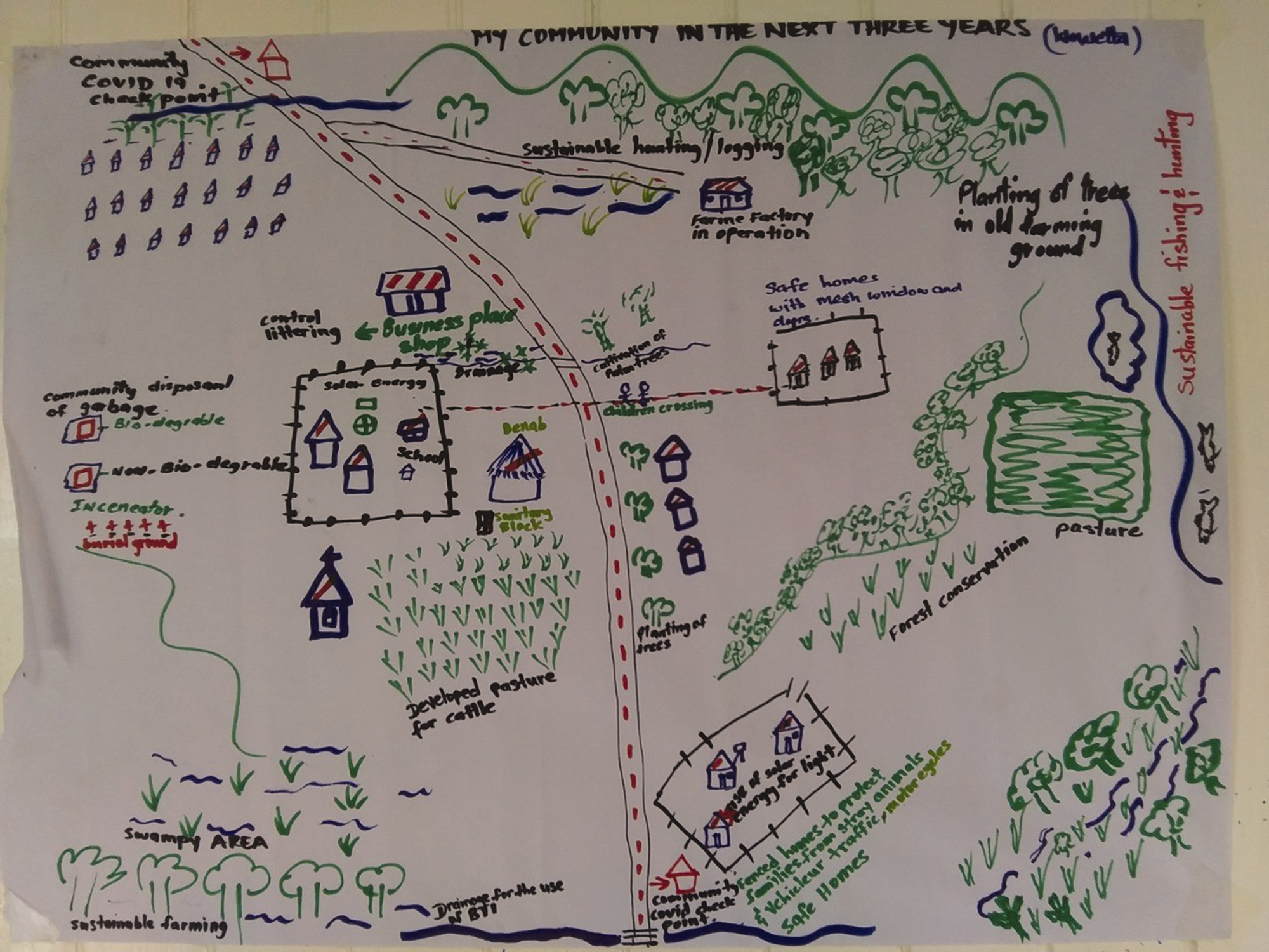
Rich picture produced in the village of Wowetta.
The exercise asked participants to draw pictures of the impact of the imagined system on their villages within a 3-year time period (including both positive and negative impacts). Instead of being directed towards prescriptive use of icons and symbols, participants were left free to decide how best to work on their pictures. In total, the rich pictures were drawn (in groups of 5–10 people) with the aim of future-proofing the system. 10 Other participants were selected as part of a national stakeholder engagement strategy and these included other village toshaos (chiefs), rangers, and ‘professionals’ working in relevant fields (doctors, environmental officers, etc.). Community perspectives on system impact were fed into its design in two ways: they supported the refining of the desired impacts (where environmental and economic impacts appear as interrelated and enabled by community governance over decision-making related to health and use of resources) and outlined other areas for the projects to consider. For example, the pictures revealed that communities seek to combine more traditional forms of protection from mosquitoes, such as using natural repellent oils extracted from local plants, with more innovative forms of vector control, as long as these were still under the control of communities.
The pictures showed that vector control cannot be disconnected from Indigenous practices of community living and livelihood generation. In a holistic view of health, people’s health, environmental sustainability and prosperity are interrelated. For this reason, while the designed vector control system aimed to produce a reduction in the numbers of mosquitoes, it also needed to take into account other community concerns: lack of jobs, changes to the climate, unlawful uses of Indigenous lands, etc. One rich picture from the village of Wowetta represents a positive view of a ‘safer’ community, where the system has not only contributed to a reduction in cases of vector-borne diseases but has also supported the communities’ plans for sustainably managing environmental resources, such as forests and the improvement of swampy areas (bottom left of the picture).
While the rich pictures enabled high-level representation of a socio-technical system, storytelling was useful to zoom into the specificities of people’s needs and their resulting system requirements. Storytelling is used in system-centred design to understand subjective impressions, motivation, unknown and unspeakable aspects of the relation between people and the objects to be designed. For its promise of challenging hierarchies of power inherent within social and political (Chan, 2021), storytelling (or counter-storytelling when directly opposing colonial narratives) is often considered as a pathway towards decolonial justice (Dutta et al., 2022; Flicker and MacEntee, 2020; Iseke and Moore, 2011). User stories captured people’s perspectives, impressions, and desires for the system and defined both the technical requirements and the social innovation that needs to underpin technology development. Social innovation is here defined as pertaining to two aspects raised by participants: the importance of collectively designing a governance structure (which includes decision-making) and identifying community needs for capacity sharing. 11 Given the oral culture of the Indigenous communities in the North Rupununi, storytelling is aligned with their knowledge systems (Iseke, 2013); it is already a tool for building relationships and strengthening community memory, which can be used in broadening networks of support (Caxaj, 2015). In challenging dominant narratives about diseases, storytelling foregrounded Indigenous agency. For example, testimonials confirmed and supported the need to practice vector control in ways that deviate from top-down approaches reliant on use of pesticides.
What differentiated our approach from other practices of user-centred design was its open-ended nature. Exercises provided a starting point for conversations and group discussions, rather than being prescriptive of expected outcomes. These (albeit limited by operating within a development framework) acts of epistemic disobedience enabled the creation of unforeseen outputs that challenged development bureaucracy. For example, while monitoring and evaluation tools were confined to the grids of a systematic logical framework (or logframe) presented as a table, the rich pictures shattered that rigidity. They depicted existing ways in which communities monitored biodiversity through Indigenous knowledges, such as the recognition of bird sounds. Incorporating this knowledge into mechanisms of monitoring the project impacts was key to propose a locally embedded process of monitoring and evaluation, as opposed to the common reliance on international consultants and development professionals. In brief, we fought against strict and quantitative measures to monitor the project and its outcomes and looked at flexible, qualitative and community-centred methods to support locally-led evaluations. Storytelling helped gather views of possible project impacts and crowd-source main system requirements.
The third method applied was the mapping and monitoring of resources, threats and environmental change through community-controlled drone surveys, access to automated remote sensing analysis of surface water distribution, and visualisation of these through a mobile phone-based mapping app. The remote sensing visualisation and mapping was carried out through a customisation of the Mapeo app, an offline open-source tool jointly developed by US-based non-profit organisation, Digital Democracy, and Indigenous peoples in Suriname and Guyana. 12 The Mapeo tool was specifically developed to address the data sovereignty concerns of Indigenous peoples. The tool operates through a peer-to-peer database, allowing mobile-to-mobile data exchange without the need for a central online server. This tool was selected to ensure that community data were protected from external uses that could provoke harm – the lack of a central data repository responded to Indigenous peoples’ request that their data was not abstracted onto the cloud and made open access for anyone to use. Open access data may make communities even more vulnerable to external harms (Carroll et al., 2020; Kukutai and Taylor, 2016). Crucially, the team worked with Indigenous researchers and Digital Democracy to augment the functionality of Mapeo to ingest remote sensing image analyses so that these maps could be used to assess resources, threats and change in-situ. The augmentation of an existing tool, rather than the creation of a fully new one, may appear to undermine the innovation potential of the projects. However, as the projects prioritised community-led decision-making, it was deemed important to invest in an app that had already responded to Indigenous peoples’ security concerns.
The collaboration with Digital Democracy created another alliance and contributed to a process foregrounding Indigenous researchers as controlling the whole ‘data sovereignty cycle’ (Figure 2). Mapeo did not simply provide users with complete information and maps – leaving them dependent only upon the external ‘cartographic gaze’ of satellite images. Instead, Indigenous researchers had the possibility to overlay their own data and fashion the information in ways which make it contextually understandable, culturally appropriate and practically useful. Due to the peer-to-peer architecture of the tool, only community members could access the information overlayed onto the local maps. Non-Indigenous researchers in the project were equally excluded from accessing the data, unless a collective decision was made to export and share it.
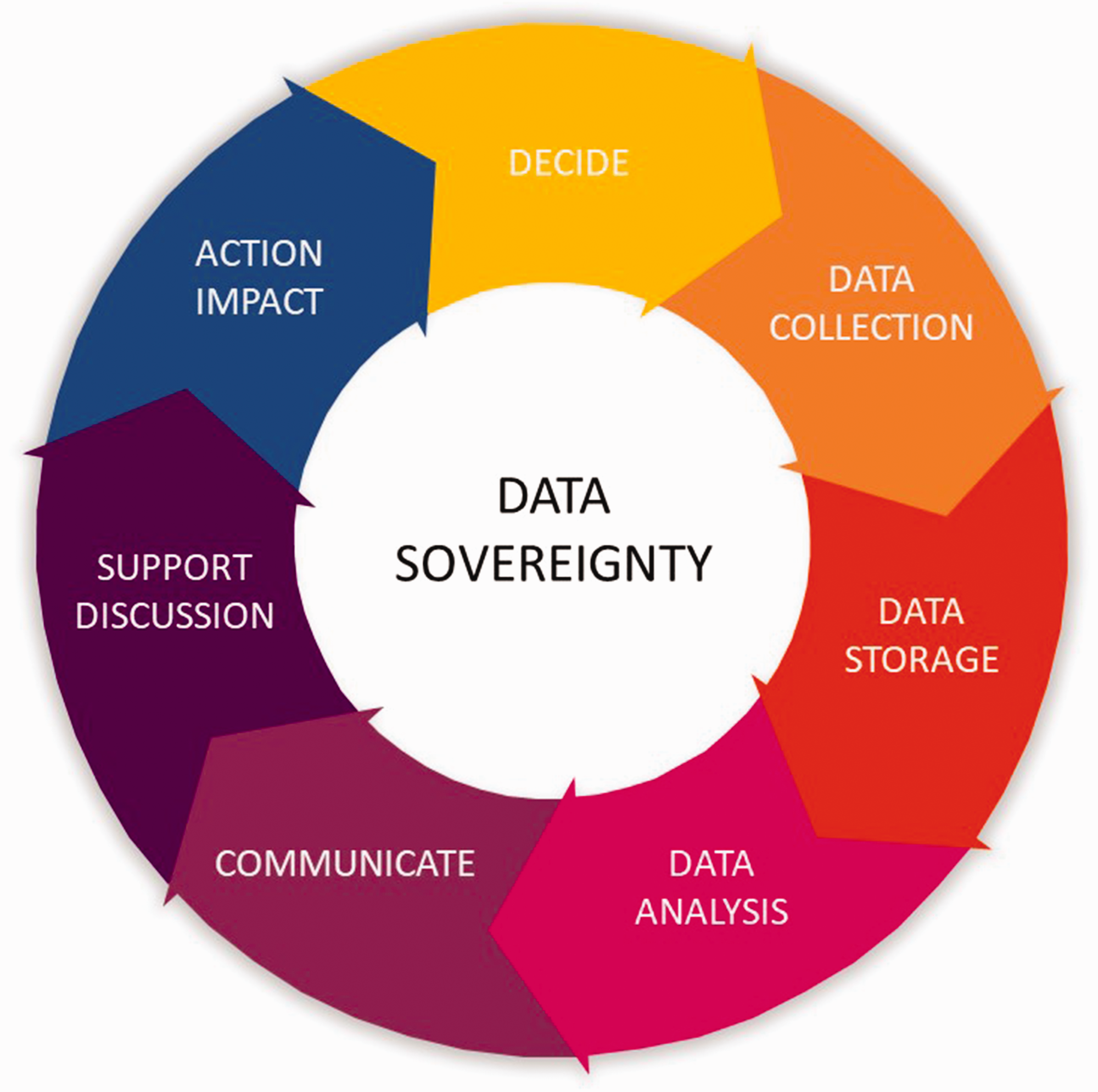
The Data Sovereignty cycle, as depicted above, may seem like a simplification of a conventional research approach. However, it was a powerful advocacy visualisation object used with Indigenous researchers to emphasise that their role was to control the whole research process, rather than the typical role of just being data collectors for foreign researchers.
Thus, our project addressed the challenge of data sovereignty by going beyond basic technology development, focusing on the Indigenous researchers managing the whole data cycle, from data collection all the way to decision-making. To this end, Indigenous researchers created participatory videos to showcase how they used the data sovereignty cycle in addressing their own local needs and challenges. 13 One of the videos, now accessible online, shows how Indigenous researchers carried out regular environmental monitoring and then used the mapping and analytical tools to identify areas that contained rare bird species which could directly support their ecotourism activities. The whole process was executed independently of non-Indigenous researchers and, months after the end of the projects, Indigenous researchers continue to use and communicate results from their Mapeo analyses through social media and other means. For example, Facebook was used as a platform to share insights from data analysis and discuss them with friends, which were mostly with members of their community or neighbouring ones. Their choice was to curate data for a known audience with a stake in community life.
One of the team’s objectives was to support an independent unit of Indigenous researchers driving environmental and social research. However, we found that the technical language of experts and Monitoring and Evaluation professionals can be a barrier to community-led initiatives. The role of experts too often entails little community consultation before deciding on what data are collected, how they are analysed and what decisions are made from the analysis. This practice of marginalising community knowledge is unjust and counterproductive: project leads often cite fear that deliverables will not be met to the required standards and timeliness if too much control is handed over to Indigenous communities. Yet, project outcomes reported on paper by those external experts disconnected from communities rarely reflect true impacts on the ground, particularly once project funding is over. Many Indigenous organisations, however, do depend on these international projects for survival, even though the knowledges these programmes value, their bureaucracy and top-down power dynamics may effectively undermine Indigenous sovereignty (although we also witnessed, and encouraged, subversive redirection of these top-down projects to meet Indigenous priorities, such as in the case of technology use for purposes other than those originally intended). Our team continues to be involved in more of those projects and will keep trying to subvert these structures. Just as the normative framework of Free, Prior and Informed consent, introduced in 1989 by the International Labour Organization Convention 169 (ILO 169), has transformed how projects are introduced into communities, there is now a need for a new international framework that enshrines Indigenous Data Sovereignty into all projects operating with and within Indigenous communities.
Data and practice: reframing impacts (a year later)
DETECT and SMART officially concluded in March 2022, and time has enabled collective reflections on their outcomes and impacts. Modest levels of ongoing funding have enabled the team to continue working on data sovereignty and accessible technologies. There is, as yet, no fully operational surface water monitoring tool or community-led vector control system, but there is progress in developing and using smaller components of it. In particular, researchers have continued to collect and analyse data from drone surveys and satellite maps. There are also other changes, which would be overlooked without a nuanced understanding of research impact. Edwards and Meagher (2020) proposed a useful evaluation framework that divides changes in five categories:
Instrumental: changes to plans, decisions, behaviours, practices, actions, policies Conceptual: changes to knowledge, awareness, attitudes, emotions Capacity-building: changes to skills and expertise Enduring connectivity: changes to the number and quality of relationships and trust Culture/attitudes towards knowledge exchange, and research impact itself
Impacts of our projects can be seen across all categories, with capacity-building being one that instigates more changes. Indigenous researchers reported that controlling the data cycle means being better able to progress Indigenous autonomy and control. As mentioned, Indigenous researchers undertook, outside the framework of the project, independent analyses of issues pertinent to local decision-making and posted their work on social media for their communities to see.
Instrumental impact was also observed also in unexpected ways. In late 2023, the Guyanese government allocated funding to individual Indigenous villages to autonomously develop and implement ‘Village Sustainability Plans’ (VSPs). Indigenous team members in one village decided to invest some of this VSP funding to purchase further environmental monitoring equipment (drones, GPS units, computing infrastructure). The aim is to undertake detailed natural resource mapping and evaluation of their territory to assess the sustainability of current land use and introduce new strategies for protecting their resources.
In workshops held in March and December 2023, Indigenous researchers spoke about their changing views and attitudes. All reported valuing their role in research differently and proposed that recognition of their leadership is now essential for any research to be carried out: Other monitoring projects or works could be coming into our communities. We are there as local people because we know our people, we know our community, we know our environment. And no one outside can come and tell us you know, let me do it for you. We have learnt, we have experience … we can do these things, you know, instead of someone from outside come in to do it for us. (Indigenous Researcher, March 2023)
The new skills gained proved instrumental for the Indigenous researchers to forge new relationships with non-Indigenous groups coming into the North Rupununi. For example, a BBC nature documentary filming crew, on realising the drone-piloting abilities of one Indigenous researcher (originally hired to simply provide guiding and logistics services), progressed to establish a new relationship where the Indigenous researcher took over the drone-filming activities and decision-making, significantly increasing the Indigenous researcher’s salary and status within the expedition. Alliances in projects can create or consolidate solidarities.
Remotely sensed data are situated and, for them to be useful and used within social settings, they need to be integrated with local, traditional, and Indigenous knowledges and practices. Instead of merely training marginalized groups to use remote sensing technologies and data, this article has focused on the possibility of technology creation to be a process that delivers changes in capacity, values, and relationships which centre Indigenous sovereignty. These impacts and outcomes reinforce our point that the pursuit of space innovation within oppressed communities should not narrowly focus on producing new technological objects as project outputs, but should account for the creative and critical processes underpinning social innovation.
Conclusion
This article discussed the inclusion of design in development using the example of two projects funded by the UKSA and implemented in Guyana. It argues that design for justice is not simply about inclusion of historically marginalised actors in technology development; it is a radical agenda for a future built around Indigenous sovereignty; one in which environmental monitoring responds to genuinely local demands. Mainstream narratives about democratising access to satellite data and space-enabled technologies, promoted by the United Nations and national agencies through various programmes, are often supported by citizen science projects that welcome the benefits of open access data. However, we have discussed an instance in which Indigenous data sovereignty, and local resistance to the abstraction of data away from the territories (and onto cloud), posed a challenge to the supposedly universal appeal of centralised storage systems and open data.
This article argued that without Indigenous leadership democratising planetary data can be at the expense of local communities. Space technology tools developed for interpreting Indigenous territories can be used for objectives that do not match, or can even actively oppose, community priorities and their self-determination. Instead, we propose that data should be grounded in local contexts, knowledge, and aspirations. This decentralization of research tools and infrastructure can be read as an effect of epistemic disobedience: a refusal of accepting the inevitability of innovation and scalability. The idea of pluriversal technologies has provided a fundamental inspiration to create a journey towards the design and use of space-enabled technologies that do not merely respond to the imperatives of development funding or the impetus of the commercial sector.
At the beginning of this article, we asked salient questions that underpin critical examination of technological solutions: who owns the technology? What are the processes of data capture? And who owns the data? In our project, the physical infrastructure (drones, computers, tablets) belonged to communities, the peer-to-peer data architecture of the app kept the data on the ground rather than backed up in Cloud, and the leadership of Indigenous researchers in setting agendas for data gathering meant that community priorities were centred in processes of data capture and use. Through a series of methods testing the needs for new technologies, as well as how the technologies vehiculated the imagination of more prosperous futures, the article followed a co-design process placing Indigenous communities at the centre of space technology development and application. While complex, this process delivers a range of material impacts that strengthen Indigenous sovereignty, from the possibility of exercising new skills to the creation of new solidarities and alliances. Imagining a more just future into being, through the medium of space technologies, appears to be both a process and an outcome of a collective practice that values Indigenous knowledges and leadership.
Footnotes
Acknowledgements
We acknowledge funding from the UK Space Agency within the IPP and the PIN2D initiative. We also want to acknowledge the support and contribution of Raquel Thomas (Iwokrama), Grace Roberts (Iwokrama) and Indranee Roopsind (Cobra Collective) to establish some of the early project activities.
Declaration of conflicting interests
The author(s) declared no potential conflicts of interest with respect to the research, authorship, and/or publication of this article.
Funding
The author(s) disclosed receipt of the following financial support for the research, authorship, and/or publication of this article: This work was supported by the UK Space Agency (UKSA) International Partnership Programme Call 3 for the '