
Abstract
Critical scholarship has interpreted ongoing mega-projects of infrastructural expansion in Africa through the lens of colonialism. Deepening this scholarship, the article questions analytical models of global coloniality or colonial continuity. To avoid reductive accounts of the ways individuals and collectives engage mega-infrastructure projects, the article proposes an alternative model of historically informed analysis, more attentive to the contingent refractions of colonial relations in geographies of insurgency, dispossession, and racialization. In particular, the article analyzes how inheritances of the Kenyatta era (1963–1978) inform communities’ engagement with Kenya’s ongoing Lamu Port–South Sudan–Ethiopia Transport (LAPSSET) development corridor project. This analysis shows how the promise of infrastructure-led development reactivates violent histories of displacement and forced resettlement. These histories orient collective efforts to transform state-sanctioned infrastructural futures, framing anticipation as a mode of redress. Closer attention to the ways in which historical experience shapes collective subjectivity and everyday agency, the article concludes, will allow scholars to develop more situated and more accountable analyses of the coloniality of infrastructure.
Abstract (Kiswahili):Usomi muhimu umefasiri miradi mikubwa inayoendelea ya upanuzi wa miundombinu barani Afrika kupitia lenzi ya ukoloni. Kukuza na kuthibitisha usomi huu, karatasi inahoji mifano ya uchanganuzi ya ukoloni wa kimataifa au mwendelezo wa ukoloni. Ili kuepuka akaunti za kupunguza jinsi ambavyo watu binafsi na vikundi hushiriki miradi mikubwa ya miundombinu, karatasi inapendekeza mtindo mbadala wa uchanganuzi wenye taarifa za kihistoria, makini zaidi kwa miondoko ya kawaida ya uhusiano wa kikoloni katika jiografia ya uasi, unyang'anyi na ubaguzi wa rangi. Hasa, jarida hilo linachanganua jinsi urithi wa enzi ya Kenyatta (1963-1978) unavyofahamisha ushirikiano wa jamii na mradi wa ukanda wa maendeleo wa Kenya wa Bandari ya Lamu–Sudan Kusini–Ethiopia Transport (LAPSSET). Uchambuzi huu unaonyesha jinsi ahadi ya maendeleo inayoongozwa na miundombinu inavyowezesha upya historia za vurugu za watu kuhama na kulazimishwa kupata makazi mapya. Historia hizi huelekeza juhudi za pamoja za kubadilisha hali ya baadaye ya miundombinu iliyoidhinishwa na serikali, na kutunga matarajio kama njia ya kurekebisha. Uangalifu wa karibu zaidi wa njia ambazo uzoefu wa kihistoria unaunda utii wa pamoja na wakala wa kila siku, karatasi inahitimisha, itaruhusu wasomi kukuza uchanganuzi uliowekwa zaidi na wa kuwajibika zaidi wa ukoloni wa miundombinu.
Keywords
Introduction
What will Lamu Port–South Sudan–Ethiopia Transport (LAPSSET), one of Africa’s most ambitious mega-projects, bring to the region? To this question, my interviewee Dr. Hussein Isack, responded with a quote he remembered: “The problem of northern Kenya cannot be solved by the same problem that created it.” 1 These words, which he attributed to Mohammed Ibrahim Elmi, Kenyan Minister of Development of Northern Kenya & Other Arid Lands, oriented the long and deeply moving conversation that followed. We were sitting on a hotel terrace in Isiolo on an April day of 2022, as election politics were stirring up altercations over cattle grazing areas in the drought-stricken region. I had come to speak with Hussein, founder of a local trust committed to the well-being and empowerment of the region’s pastoralist communities, about infrastructure development. Yet our conversation quickly shifted to his memories of the Shifta War (1963–1967). This war was launched by the Kenyan state against insurgents, after the region’s unsuccessful attempt to attain political self-determination in the process leading to Kenya’s independence from Britain in 1963. Hussein lamented the silence of his generation, which hardly talked about the destruction of their livestock, the concentration camps, the surveillance, and the systematic physical abuse they and their families suffered during those years at the hands of the Kenyan military. In his mind, the problem—now and then—was the Kenyan state and LAPSSET was only its most recent manifestation.
Officially launched in 2012, the LAPSSET (Lamu Port, South Sudan, Ethiopia Transport) Corridor aims to connect a new port at Lamu with landlocked Ethiopia and oil-rich South Sudan. Its pipelines, highways, fire-optic cable, railway, three airports, resort cities, dam, and special economic zones promise to spur unprecedented economic development (Figure 1). LAPSSET is central to Kenya’s current national development vision, known as “Kenya Vision 2030,” which aims to turn Kenya into a middle-income country by 2030 (Browne, 2015; Fourie, 2014). But it is not just a Kenyan project. Financed by a global mix of institutions, it has been adopted as one of the leading projects of the African Union and the East African Community and forms part of China’s Belt and Road Initiative (Otele, 2020). The corridor is to be extended into Central and West Africa, creating a “Great Equatorial Land Bridge” that would facilitate continental economic integration.
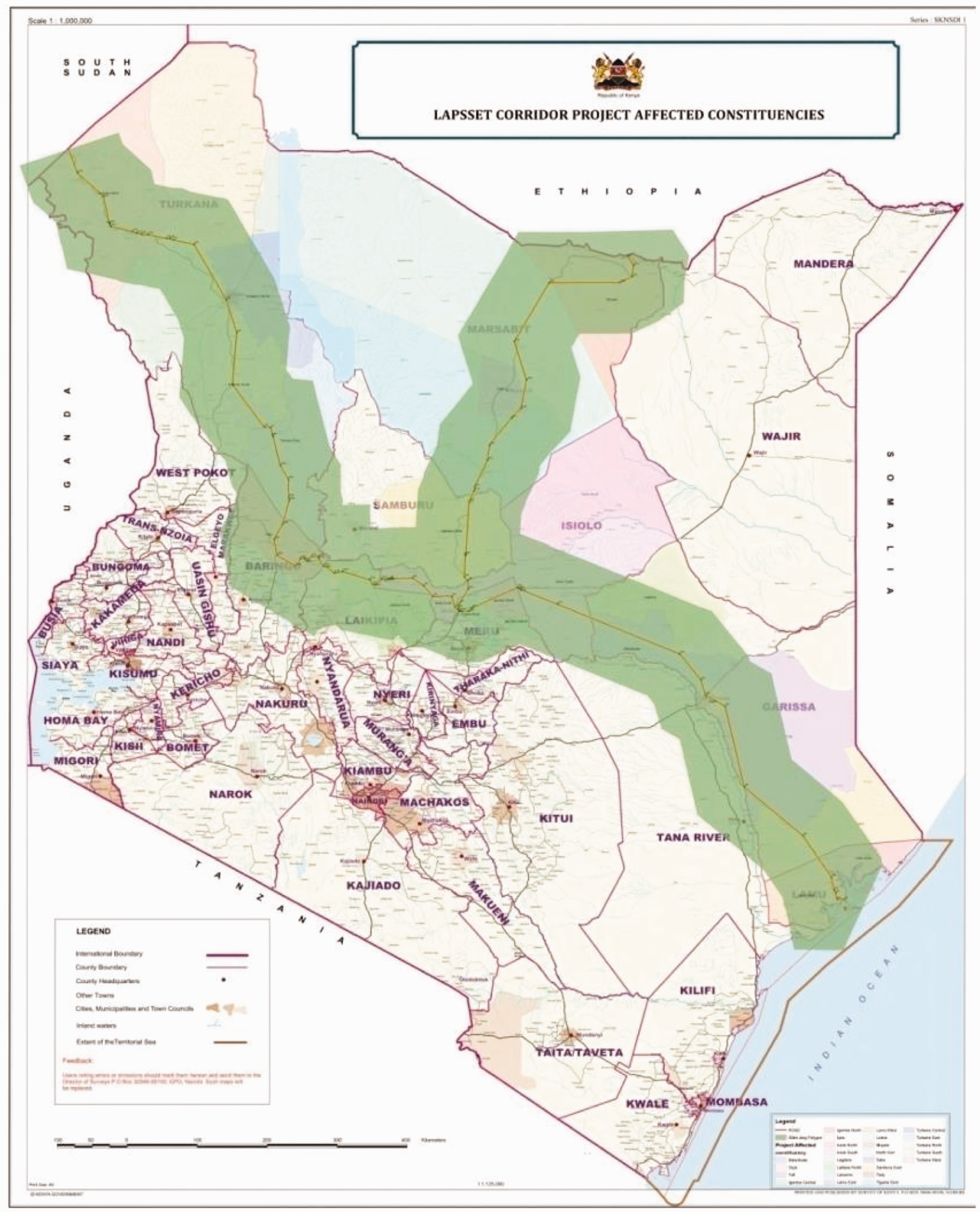
Map indicating LAPSSET’s trajectory through northern Kenya, highlighting its promise of development (Source: LAPSSET Corridor Development Authority, “LAPSSET Corridor Program: Status Report,” September 2017 (online).
LAPSSET’s future, however, remains uncertain, with geopolitical shifts and with communities contesting and engaging the project in different ways (Aalders et al., 2021). Land speculation and the opportunities of incoming investment have already turned promise into wealth for some. For many others, including fishing communities in Lamu, where the first part of the new port opened in 2021, LAPSSET is a Nairobi-dictated project engendering environmental destruction, land dispossession, and the loss of livelihoods (Bremner, 2013; Chome, 2020; Lesutis, 2022; Mahajan, 2017). In Isiolo, the project has spurred communal and individual processes of land speculation and homebuilding but also threatens vulnerable pastoralist livelihoods (Aalders, 2020a; Elliott, 2018). International consultants and political elites may present the LAPSSET corridor as the answer to economic uncertainty and regional conflict, but for many residents in the region it is a cause of unsettlement. Entangled with these infrastructural dynamics is the specter of terrorism. From the perspective of the region’s predominantly Muslim communities, the Shifta War never really ended and remains at the heart of the current “war on terror” the government now wages on Al-Shabaab militants in collaboration with the American military. LAPSSET facilities and construction workers have been targeted in deadly attacks, casting doubt on the idea that this development corridor is a road to peace (Kilaka, 2022).
Studying African infrastructural futures, this article argues, requires a sustained engagement with the ways in which historical inheritances are contested and remade. Scholars have framed corridors like LAPSSET as “global infrastructure,” tying Africa into an Asia-centric logistical world and thus into the planetary fabric of late-capitalist urbanization (Neilson et al., 2017; Wiig and Silver, 2019). Instigated by the unprecedented scale of China’s Belt and Road Initiative, they analyze mega-scale infrastructure development as a spatial fix to the overaccumulation of Chinese capitalism, as a new geopolitical race for resources, and as a new form of urbanism (e.g. Apostolopoulou, 2021; Elliott, 2018; Ross, 2020; Silver, 2021). An emerging strand of scholarship foregrounds the endurance of colonial relations of power at the heart of this global infrastructure push. 2 In this vein, Charis Enns and Brock Bersaglio (2019) have shown how LAPSSET and other ongoing corridor projects in eastern Africa reiterate European colonial projects of territorial penetration, control, and exploitation. Comparing LAPSSET to the Uganda Railway, Johannes Theodor Aalders (2021 b) has traced colonial continuities and discontinuities in terms of mobility patterns and temporal orientations. Focusing on the Standard Gauge Railway, another Chinese-backed mega-infrastructure project in Kenya, Wangui Kimari and Hendrik Ernstson (2020) have analyzed how such new infrastructure projects can be seen as “imperial invitation,” arguing that colonial racism underlies what they see as the persistent anti-Blackness of Kenya’s infrastructure boom. Most recently, Gedimanis Lesutis has argued that the Lamu port project shows how the “coloniality of power reverberates through contemporary mega-infrastructures” (2023).
Altogether, this scholarship does much to account for the ways in which colonial, and thus racialized relations of power inhabit African mega-infrastructure futures. As Kimari and Ernstson suggest, engagement with the Black radical tradition offers a much-needed deepening of current “Southern” scholarship on infrastructural politics, particularly in terms of race. Following this suggestion, Lesutis draws from the coloniality/modernity literature and Black feminist theory, which leads him to interpret individual and community responses to the LAPSSET project as relying “on colonial grammars of sub-humanisation to maintain a sense of self in the world of not their own making” (2023: 1). While his analysis offers a powerful interpretation of the category of ethnicity as integral to global structures of racism, it risks reducing people’s sense of belonging to racial biopolitics and colonial grammar.
To appreciate the ways individuals and collectives engage mega-infrastructure futures on terms that are also their own, I suggest attending to the models of history undergirding infrastructural analysis. Despite repeated recourse to Ann Stoler’s (2016) work on imperial durabilities, infrastructure scholarship would benefit from attending to her insistence to attend to the multiple temporalities in which people live: what is past but not over; how the articulation of past and present may recede and resurface; how colonial relations are disparately and partially absorbed into social relations and ecological disparities and are productive of very distinct dispositions toward how—and, indeed, whether those histories matter today. (Stoler, 2016: 25–26)
Answering these questions contributes to a theory of history that centers the capacity of individuals and collectives as both history-makers and future-makers. This means shifting away from showing how “the coloniality of power reverberates through infrastructure from the past into the present” (Lesutis, 2023: 3) and instead to pursue situated analysis that accounts for historical refractions of both colonial power and anticolonial struggle. The notion of refraction exceeds linear understandings of dis/continuity as well as structural models of inheritance as it foregrounds changes in direction, intensity, and duration.
Grounded in empirical research, the following analysis thus builds on two established strands of argument. First is the longstanding argument in Africanist and Southern scholarship that a rigid focus on colonialism’s enduring legacy tends to underplay African agency (e.g. Jennings and Burton, 2007: 1), and risks reproducing Western views of the rest of the world as no more than “the consequence of an original agency identified as exclusively and deplorably its own” (Tadiar, 2022: 258). In infrastructural scholarship, this argument is reflected in Van der Straeten and Hasenöhrl’s (2016: 374) insistence that to “avoid straightforward ‘tools of empire’ stories, we moreover need to analyze the fullness of system interactions and actors, not just the (colonial) ‘system builder’ at the top.” Aalders (2021b: 1010) similarly explores “the ways in which different actors, including people living near the LAPSSET corridor, actively imagine, shape and challenge the complexity and ambiguous scalar hierarchies of modern globalised capitalism.”
The second line of argument is to take more seriously the ways in which the infrastructures of post-independence nation-building disrupted or otherwise transformed colonial structures (Miescher, 2022; Monson, 2006; Reynolds, 2017). In the case of Kenya, such a focus needs to extend beyond the rhetoric of nation-building to include its associated conflicts, in particular the Shifta War as already indicated by Aalders et al. (2021: 16). Furthermore, infrastructural analysis should integrate historical scholarship on belonging, mobility, and racialization in Kenya and the larger Muslim and Indian Ocean worlds.
In what follows, I build on these scholarly insights to show how historical experience shapes individual and collective forms of subjectivity and agency in the context of imposed infrastructural futures and global, racialized hierarchies of power. New infrastructural projects bring up old grievances and aspirations, historical injustices or memories of a glorious past, and these multiple reactivations in turn influence their course. To explore how anticipations of infrastructure constitute forms of historical redress, this article focuses on histories of racialized violence and infrastructure building during and after the Shifta War. These historical experiences, linked to anti-colonial liberation in complex and indirect ways, orient community engagements with the LAPSSET project and shape efforts to transform its state-sanctioned future.
My research entailed three months of fieldwork, 30 semi-structured and life story interviews with representatives of non-profit and community-based organizations in Lamu and Isiolo, and archival research at the Kenya National Archives. Archival research provided key insights about national infrastructure policies, the stated and implicit aims of which often contradicted those perceived by local communities—as discussed in section ‘LAPSSET’s infrastructural inheritance’1. It is in such contradictions that the research finds refractions of colonialism after formal independence. Sited research focused on Lamu and Isiolo, as LAPSSET’s primary “hotspots” where infrastructural futures are contested and negotiated—though in different configurations of state and non-state actors, as discussed in sections ‘Building pastoralist futures in Isiolo’ and ‘Displacement and the prospects of resettlement in Lamu’, respectively. Some respondents were selected in collaboration with coastal heritage expert Mohammed Mchulla and Nairobi-base architect Kabage Karanja (Cave Bureau), with whom I conducted the initial phase of interviews (in English and Swahili) in Lamu. In Isiolo, Dr. Hannah Elliott and Dr. Hassan Roba were instrumental to the establishment of a local network of respondents, as was the on-site logistical assistance of Emmanuel Ekiru. All the interviews were conducted by myself in English or Swahili with assisted translation. The range of respondents limits the claims made in this article to their role in mediating community experiences, which is further corroborated through existing historical scholarship.
LAPSSET’s infrastructural inheritance
Large-scale infrastructure became central to Cold War techno-politics and its promises of development, and this fundamentally impacted the course of state-led decolonization and nation-building in Africa. In the 1950s and 1960s, emerging African political elites portrayed roads, dams, ports, highways, railways, and other large-scale construction and infrastructure projects as the unquestioned material basis of national and international development. Some of these projects originated as late colonial schemes, retooled to suit new development goals. Yet despite reliance on foreign expertise and funding, newly independent African governments were often successful in bargaining advantages with competing Cold War powers.
Despite its rhetorical alignment with African socialism and the Non-Aligned Movement, the Kenyan government, under the presidency of Jomo Kenyatta (1963–1978), sustained close ties with Britain and favored the West (Cullen, 2018). This position shaped not only national infrastructure development but also the project a Trans-African Highway network across the continent (Cupers and Meier, 2020). As opposed to the colonial infrastructure of railways and ports, highway infrastructure was imagined as a means by which Africans could become economic producers as well as consumers, and African countries could connect with themselves to finally turn capitalism to their advantage. After independence, road development was portrayed “as nation building in its truest sense,” in the words of Minister T.C. Chekwe. 3 At the same time, highways were paradoxically imbued with dreams of mobility and belonging tied to aspirations of political self-determination—not just of individual states but of the African continent as a whole. In this sense, the Trans-African Highway can thus be understood as an inspiration for LAPSSET, as is illustrated by the concept of an “equatorial landbridge” (Figure 2).
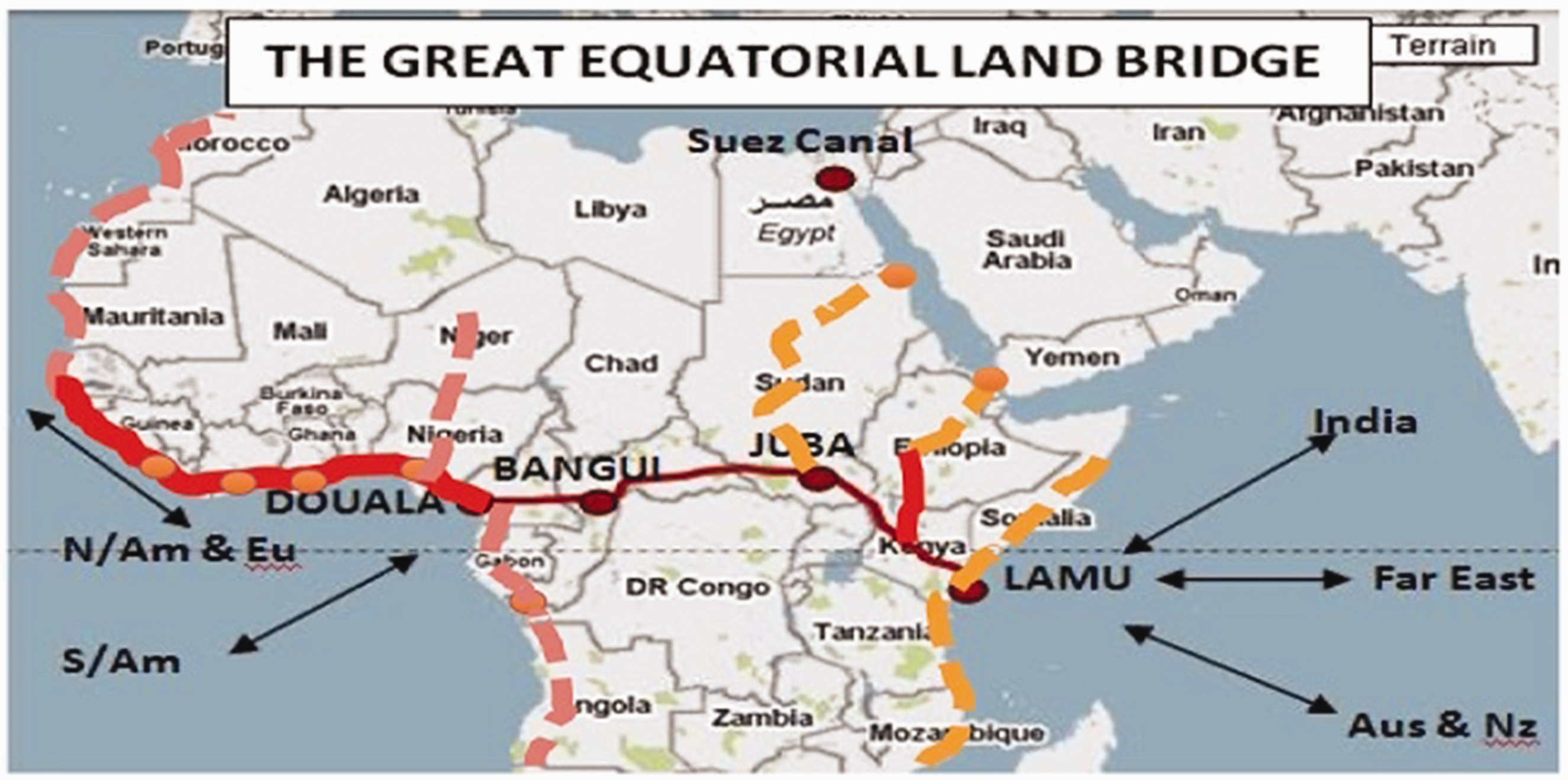
The Great Equatorial Landbridge was presented in 2013 as part of the LAPSSET project, illustrating its ambition to boost continent-wide interconnectivity between African cities and nations (Source: LAPSSET Corridor Development Authority, “LAPSSET Corridor Project, presented during Kenya-UK investment conference,” 3 December 2013 (online)).
Despite this Pan-African imaginary, however, infrastructure development in Kenya remained organized around extractive logics inherited from colonial era. The work of the road department, as stated in its 1970 report, was focused on long-distance “trunk roads” such as the Mombasa-Nairobi highway and on “economic project roads such as tea, sugar, and tourist roads.” 4 The effect of this policy was particularly palpable in the so-called “white highlands” area of central Kenya, where road construction and maintenance decisions were made in the interest of tea and coffee plantation producers. 5 Smooth-asphalt “tea roads,” funded by the World Bank, facilitated access to large-scale plantations on alienated land, while the homes of their rural workers were often accessible only by dirt road. 6
When we look beyond this official discourse of infrastructure as development, its role in ongoing struggles for self-determination emerges from the shadows of Kenya’s nation-building project in the period following formal independence. These struggles are represented in this map (Figure 3), drawn in 1968 by Edward Soja, the geographer who later became known for his work on postmodern geographies based on research in Los Angeles. Soja spent about a year in Kenya. The aim of his study was to map what he called the country’s “spatial patterns of modernization”. Soja stated that these patterns were to a large extent the result of the British colonizers. He understood modernization as a linear process of development, resulting from the construction of transportation, communication, and media networks that would foster geographic mobility, social mobilization, political participation, and the breakdown of what he called “ethnic compartmentalizations.” His view of African polities as premodern tribes becoming modern only through contact with Europeans was part and parcel of late-colonial racism—hence, ancient globally trading port cities like Lamu had to be “Arab,” because they simply could not be African. 7 The map, however, can also be read as a representation of the infrastructural legacies of colonialism at independence. Key to this was the Uganda railway line, built from 1896 to 1901 to connect Mombasa with Uganda, running through the white settlements in the highlands of the Rift Valley. The colony of Kenya was historically built around this trunkline, which fueled the growth of Nairobi and facilitated the plantation economy of central Kenya. The LAPSSET project is similarly presented as ‘opening up’ the vast northern region of Kenya to development (Aalders, 2020b; Enns and Bersaglio, 2019). As a technique of governing and motor of accumulation, the colonial trunkline thus conceptually prefigures the development corridor.
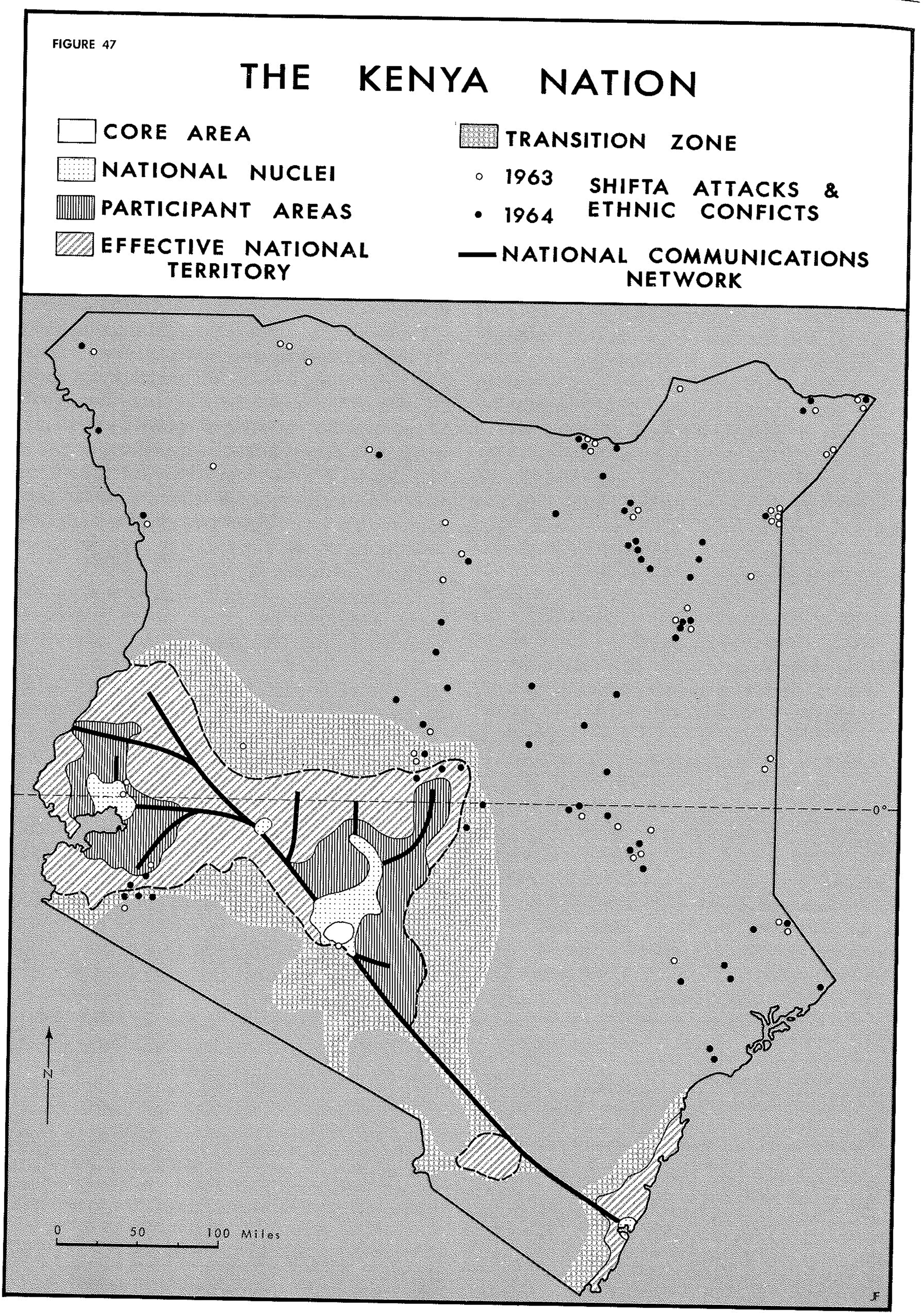
“The Kenya Nation” by geographer Edward Soja (Source: Edward Soja, The Geography of Modernization in Kenya: A Spatial Analysis of Social, Economic, and Political Change (Syracuse: Syracuse University Press, 1968, p. 108).
By all Soja’s quantitative and qualitative measures, the vast northern and coastal regions of the country (the majority of Kenya’s land surface) were undeveloped and peripheral. That was very much how British colonialists had long viewed and attempted to govern these lands: as no-man’s land or buffer zone between its settler colonial heartland around Nairobi and its neighbors—the Ethiopian empire and Italy-occupied Somalia. Soja’s map of the “Kenya Nation” then not only summarized the infrastructural legacy of British colonialism, but also conveyed its epistemological legacy—a colonial, racist model of modernization mapped onto space. A key to the troubled nature of this double inheritance are the dots on the map, which Soja labeled “Shifta attacks and ethnic conflicts.”
Even today, inhabitants of this region still speak about “going to Kenya” when they plan a trip to Nairobi or the southern central areas of the country, conveying their historical marginalization as well as an alternative sense of regional belonging (Kochore, 2016; Mosley and Watson, 2016). A referendum in 1962 showed overwhelming support by the region’s Somali majority to join the newly formed Somali Republic. Yet the Kenyan government refused to cede the territory. Following growing conflict with Somali irredentists, the government launched a series of counter-insurgency measures, directed against the region’s predominantly pastoralist population. These measures involved the strategic deployment of security infrastructure and bore strong similarities with the counter-insurgency strategies used by British colonialists against the Kenya Land and Freedom Army (also referred to as the Mau Mau) just a decade earlier (Whittaker, 2015). During this anti-colonial struggle, British forces had forcibly moved Kikuyu communities into guarded settlements, some of which also functioned as labor and detention camps (Anderson, 2012; Elkins, 2005; Kariuki, 1975). In an obscene twist, the Kenyan government, now led by the Kikuyu-dominated Kenya African National Union (KANU) party, adopted this same strategy of forced villagization to control the insurgency in northern Kenya. In 1967, they rounded up Somali and Borana pastoralists and forced them into “villages,” guarded by the military, surrounded by barbed wire and thorn bushes, and lit with surveillance lighting (Bloch, 2017).
The Shifta War may be understood as a refraction of colonialism after independence. Yet it is not simply the colonized becoming the colonizer, with a new economic elite capturing the (colonial) state apparatus. The war was shaped by complex power relations and social dynamics in which the racialization of Africanness took an important role. Many of the region’s Cushitic-speaking, predominantly Muslim residents were sympathetic to secessionism because they did not want to be ruled by “Africans,” by which they meant Black Kenyans (like Kenyatta himself) who had come to dominate the state in the transition to independence. 8 This anti-Blackness was shaped not only by North Atlantic colonial hierarchies but also by other, older histories of enslavement and Muslim communal belonging in eastern Africa (Becker et al., 2023; Weitzberg, 2017). At the same time, this particular mobilization of race was but one of several layers in what was ultimately a struggle over self-determination. As roads and camps were central to the Shifta conflict, infrastructure is not to be understood as either an instrument of colonialism or a symbol of self-determination but rather as a complex disposition through which we can see racialized relations of power being contested and rearticulated.
The Shifta War also adds another new dimension to our understanding of the politics of infrastructure development during the Kenyatta era. In the late 1960s, the government invested in the upgrading of an existing trunk road from Nairobi to Ethiopia’s capital Addis Ababa. This marram road, “Hell’s Highway,” was presented in the press as a grand gesture of pan-African cooperation with Ethiopian Emperor Haile Selassie. Elders in the region, however, remember this marram road as a rough track, only used by trucks, and thus rather a sign of the region’s marginalization from development. Both Kenyan and Ethiopian governments had already been cooperating in their response to the Somali conflict since the signing in 1964 of a Mutual Defense Treaty. Soon after the UNECA adopted the Trans-African Highway, the route was integrated into the network. Regardless of its accompanying pan-African rhetoric, the road extended Kenyan state power into the northern region, which experienced continued conflict even after forced villagization. Highway construction, by an Italian firm, was regularly disrupted by attacks, “which involved the use of modern methods of war, laying of mines and ambush of people traveling the road. This required the services of the army and GSU units.” 9 Highways were thus not only instruments of regional integration, but also instruments of state territorialization in a region whose inhabitants sought another form of sovereignty (Kochore, 2016).
In Kenya’s national road plan of 1978, right at the end of Kenyatta’s reign, road development was still predominantly focused on southern and central Kenya (Figure 4). Infrastructure projects and other forms of development in the northern region after the Shifta war remained similarly minimal. The Kenyatta government did build some schools and other basic amenities in the concentration camp villages. 10 These were supposedly meant to “uplift” their distrusted populations, mirroring British colonial rhetoric. Yet the forced resettlement villages and the period of the Shifta War more generally are known as dhaabaa in the Borana language, “life interrupted” (Khalif and Oba, 2013). Not only did people suffer beatings and rape at the hands of the Kenyan Army in these camps; they also saw their livestock killed, and their pastoralist way of life destroyed. The few investments that the Kenyan government made in the northern and coastal regions affected by the Shifta War were largely focused on the settlement of landless people, particularly those who had been dispossessed by the British in central Kenya. The only positive legacy of this era was the construction of schools—even though literacy in the region is still below national average.
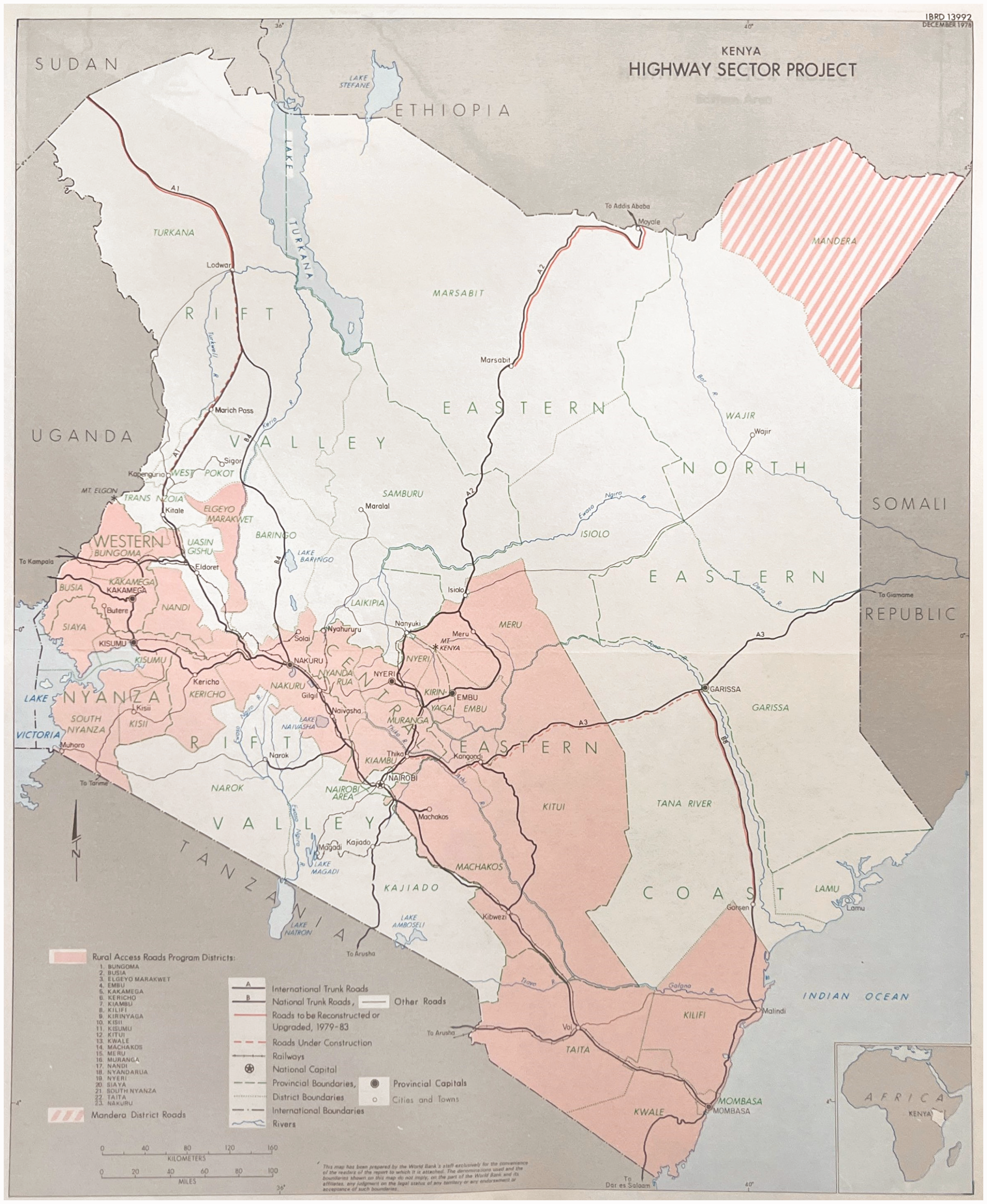
Kenya’s highway sector plan of 1978 (Source: Kenya National Archives, AVQ/15/46: Road transport policy vol 3).
In the north, LAPSSET-fueled urbanization builds on the physical and psychic imprints of this violent history. Military impositions and state development interventions have fundamentally reshaped lives in the region, including practices and meanings of settlement and mobility. The implementation of LAPSSET reactivates memories of a difficult past and fuels further mistrust. At the same time, some elements of the LAPSSET project are celebrated as vehicles of economic opportunity and are even placed in the historical context of African liberation. For example, Marsabit Governor Mohamed Mohamud called the Isiolo-Moyale highway, the first completed element of LAPSSET, a game changer in Northern Kenya: “Completion of the road is like another liberation for us. Kenya fought for independence for so many years until 1963 when we attained that freedom but for us complete freedom was realised when that road was launched.” 11
The Kenyatta era thus constitutes a complex and contradictory set of inheritances that LAPSSET contends with. The project does much more than replicate Kenya’s colonial-era trunkline to “open up” the country’s new resource frontier for development. It also mobilizes aspirations of national and Pan-African development, even as the project builds from a darker history of expanding state power and quelling regional self-determination. These inheritances are tied to British colonialism, though in oblique and refracted ways.
Building pastoralist futures in Isiolo
Despite its location in Kenya’s geographical center, Isiolo has long been understood as a frontier town. Marking the transition between the more densely inhabited agricultural area of central Kenya and the arid pastoralist lands of Kenya’s northern and eastern regions, the town is also a crossroads. The city’s cattle herders, khat sellers, market people, military officers, businesspeople, and government workers that find their home in Isiolo often move between remote rural towns and homesteads, house plots or rentals in town, and business or employment in Nairobi or beyond. For pastoralists from the surrounding region, Isiolo is often the “first stop,” the first urban center they encounter as they bring their herds to market. But until recently, Isiolo was more often described as the “last stop,” before travelling on the marram road up north.
On 26 July 2017, president Uhuru Kenyatta (Jomo Kenyatta’s son) opened the newly tarmacked road from Isiolo to Moyale at the Ethiopian border. 12 The road, as was widely appreciated, cut down travel time from three days in the back of a truck to a mere six hours. Consequently, Isiolo’s LAPSSET officer Abduba Nagele insists in our interview, it has significantly boosted prosperity in the region. 13 Trading centres have sprung up all along the new road, and the increasing regional connectivity (including mobile phone reception on the road) has led to a significant expansion of commerce and improvements in medical service delivery. Isiolo’s new public market building, currently under construction, is also a direct consequence of LAPSSET’s infrastructural investment, Nagele asserts. 14 Other local elements of the LAPSSET project include the international airport, the road from Lamu to South Sudan over Isiolo, a planned resort city, and a new slaughterhouse. 15 Feasibility studies for the resort city, planned in the Kipsing Gap area outside town, have been finalized, but after communities protested its location on an important wildlife corridor, the government is currently exploring alternative locations according to Nagele.
With these LAPSSET-related developments, Isiolo is being recast as a future metropolis and a gateway to Kenya’s “new frontier.” Anthropologist Hannah Elliott (2018) has shown how anticipations of infrastructure development have fueled practices of property-making in Isiolo, as individuals and collectives claim increasingly valuable plots of land on the urban outskirts. The city has seen rapid growth: from little more than a roadside settlement a few decades ago, the city now counts around 200,000 inhabitants, and many locals believe it might become five million in the not-so-distant future. At the same time, her study shows how LAPSSET-fueled property-making is rooted in a longer history. Towns in the region, including Isiolo, were first established by the British. They were effectively “places of government,” and even though thriving pastoralists would have avoided these for various risks not in the least taxation, they were also places to which poor and marginalized people gradually sought political access and belonging (Elliott, 2018: 88). After its establishment as the district headquarters of the northern region in 1929, the British colonial government discouraged so-called “natives” from settling in Isiolo, much like they did in other colonial towns. Isiolo nevertheless grew with small villages around it as different groups settled to generate political power and claimed belonging to town.
Portrayals of the town as a peripheral backwater having suffered long-standing neglect and now becoming a “new frontier” of development may give the impression that the LAPSSET project constitutes the first or most direct encounter of the region’s inhabitants with the state. Nothing could be further from the truth for people like Hussein Isack. When the Shifta War started, Isack explains, I was very young, like 8 or 9. I was at home in Merti. I never saw any permanent building at the time. I never saw rice, a bottle, chapati … Independence, we were not aware of it. Suddenly the Kenyan army were everywhere.
16
Other representatives of community and non-profit organizations, established in recent decades to support pastoralist communities, recount similar experiences. Jarso Mokku, leader of the Dryland Learning and Capacity Building Initiative, was also born into a pastoralist family in Merti. There was no permanent settlement in the area until the Kenyan military forced him and his family into the camp, where they continued to live after the end of the war. He remembers the camp was fenced with shrubs and had only a few makeshift shops. Families had built their own houses, traditional round structures that made up the camp. The military built a primary school in 1966—Mokku remembers the year because his brother was one of the first students then. “The weakest ones went to school, the stronger ones continued herding. This created conflict, as those schooled tended to become close to government.” He himself feels like he is in between two worlds. “I can explain what is coming [with LAPSSET], but they just see their village and their pasture.” Mokku now works to secure title deeds for community land in the region in response to LAPSSET, as “land is the most important thing to prepare people for what is coming.” 17
Dr. Daoud Tari, one of the founders of the Kenya Pastoralist Forum, was also interned in a camp. His extended family became destitute after having their livestock annihilated by the Kenyan army. “The only positive impact of war was education, school for some people,” including himself. 18 Even those born after the war had officially ended in 1967 remember growing up in a period of terror. Insurgents would continue to attack pastoralist communities in smaller groups, and government intervention continued through targeted military actions and camp management. Dr. Abdub Molu Ido, a development scholar and activist for pastoralism in the region, was born in 1972 “in a village called ‘prison,’ a suburb of Garbatula. It was called like that because it was a concentration camp.” His community never fully recovered from the experiences of terror. Many died from disease in the concentration camps. Others fled in search for a new life abroad. Still others were trying to “pick up the pieces” amidst the ruins, as Ido recounts. But with their livestock confiscated or shot, families could not return to pastoralism. Despite the construction of schools, hospitals, and some communication networks, the majority remained dependent on aid. People moved to bigger towns like Isiolo in search for subsistence. Churches came with food relief programs and orphanages. “This is how life began again,” according to Ido. “The current insecurity of this area today can be traced back to this era.” 19 As a representative of Ardha Jabesa, a recently established foundation that aims to support women and girls from pastoralist communities in Isiolo county, states, “most problems we have now are caused by the Shifta war.” 20 Whether it is in livelihood programs, natural resource management and advocacy, or educational support to maintain traditional culture, the consequences of the war are felt everywhere.
The war did not only destroy pastoralist lifeworlds; it also shaped the fraught course of urbanization in the region. The military strategy of villagization was not meant to “urbanize” the region as such, but to pacify it by violent means. The counter-insurgency infrastructure of roads, fences, and camps remained as a landscape of ruins in which people tried to build new lives with the continued involvement of the Kenyan state, missionaries, and non-profit organizations. This is not a new “frontier” of the urban, defined by the petering out of urban activities in some sort of untouched pastoralist realm, or by extended operational landscapes tied to urbanization (Schmid and Topalovic, 2023), but a region shaped by colonial history, the traumas of state violence, and the extensive reach of the international development industry.
Isiolo, like other towns in the region, was thus shaped by the Shifta War in multiple ways. For traumatized and impoverished individuals and families who were unable to build up new livestock and stay in the region, Isiolo offered refuge. At the same time, Isiolo was also targeted by the counter-insurgency program of the Kenyan military, with existing Somali and Borana neighborhoods fenced off. Mwalimu, a Somali pastoralist and teacher I interviewed on several occasions, grew up in one of these fenced neighborhoods in Isiolo. 21 Mwalimu’s father was born in Ethiopia, but moved to work in a white settler farm in Nanyuki (central Kenya) in 1944, where he met his wife. When the Shifta War broke out, the family was forced to leave the farm and moved to Isiolo, where they were interned. Mwalimu’s village, one of several fenced villages in Isiolo during the war, had first been settled by Somali soldiers who had fought for the British in the First World War.
For Mwalimu, like for so many others, the notion of settlement and the experience of home is inextricably tied to state violence. His village was entirely fenced, with only one, closely guarded gate. Military forces could come at any time to round people up, dividing them into groups of women, men, and children. Mothers were beaten up, their head scarfs removed. Fathers were beaten, forced to work, some died. In four years, their family’s livestock was continually destroyed. During our walk, Mwalimu showed me where the entrance gate was, how the fencing ran around the village, and where people were rounded up. 22
The impact of the war on Isiolo, however, extended beyond these neighborhoods as such. The town grew with many pastoralists from the region settling in Isiolo, not only as a result of the war violence but also due to the subsequent years of drought. Many continued to keep livestock either on their plots or on the outskirts of town. During the 1970s and 1980s, the central government continued to rule the North primarily in terms of security. The establishment of more military facilities turned Isiolo into a modern city of sorts. The government built two military camps, the School of Infantry, and Tank Battalion, around 1978. This was the time when Isiolo was electrified and piped water became available. The military fundamentally changed the face of Isiolo. New roads were built to serve the camps, and many businesses, such as butcheries and groceries, sprung up to supply the army population. This brought architectural changes too, with modern concrete construction for new shops and hotels.
State investment in educational and medical infrastructure, however, remained minimal, and the region was still considered a “low potential area.” The few development projects launched by the government were markedly anti-pastoralist. In Isiolo, the government ran agricultural settlement and irrigation schemes that aimed to permanently settle pastoralist families. Such schemes were successful in so far as they helped some of these families to sustain themselves economically until they were able to buy new livestock and resume their traditional livelihoods (Hjort, 1978: 56). This push for sedentarization mirrored colonial interventions, Elliott notes (2018: 106). At the same time, it can also be understood as a refraction of historical experiences of colonial dispossession elsewhere. The ruling party, the KANU had come to power in central Kenya, where agriculturalist communities were alienated from their land to make space for British plantations and settlements. This regional context shaped the Kenyatta government’s approach to agricultural land ownership as cornerstone of post-independence citizenship and development for Kenya as a whole.
In a city where many families still hold livestock, the central question is the extent to which Isiolo’s future will include pastoralism. Many elements of LAPSSET’s plan for Isiolo, such as the international resort city, are blueprints from elsewhere. These imports map onto a long history of government schemes whose logic is derived from different contexts. In addition to the push to preserve an important wildlife and pastoralist corridor against the construction of the resort city, the element of LAPSSET that perhaps speaks most directly to the stakes of pastoralism is the slaughterhouse. This project was not originally part of LAPSSET, but has been recently included in its portfolio, signaling LAPSSET’s commitment to “support the local livestock industry and connect it with international markets.” 23 Representatives of non-profit organizations supporting pastoralism, however, question whether this project will serve local interests. The project brings up questions not only about the future of pastoralism but also about the past. The site for the slaughterhouse project is Isiolo Holding Ground (also known as Livestock Marketing Division), on the western side of the town. The holding ground was established by the British colonial government in the 1920s as a cattle disease buffer, which would protect white settlers’ cattle in central Kenya from pastoralist cattle migrating southwards for sale or butchering. The Kenyan government inherited the vast site and its sprawling veterinary facilities after independence, when the site continued to be used for quarantining and livestock marketing. The plan to develop the site and build the slaughterhouse has not moved forward as several competing groups of pastoralists, and the Kenyan military, have conflicting historical claims on the land.
But even when the project moves forward, the kind of future it would bring remains uncertain. For Nagele, “livestock keeping is endangered by climate change and land scarcity. The answer to this is quality over quantity.” The future of pastoralism as he sees it is ranching in small, enclosed paddocks, which could radically increase meat production. Such a shift, however, would be the end of pastoralism as those who practice it today understand it. A lifeworld essentially grounded in mobility across arid lands would be replaced by agro-industrial, capital-intensive business. Nagele portrayed the slaughterhouse as a key step in this desired transformation. Yet the possibility remains that it may lead to further inequality rather than local prosperity if it entails non-local investors and uneducated locals reduced to cheap labor. It is unclear as of yet if and how the slaughterhouse will put pastoralism in the service of global accumulation. Yet if the recent success to move the location of the planned LAPSSET resort city away from an existing wildlife and pastoralist corridor is any indication, the slaughterhouse project might be transformed to safeguard pastoralist livelihoods, and in doing so redress a long history of injustice.
Displacement and the prospects of resettlement in Lamu
In Lamu, the planning and construction of the new LAPSSET port have provoked a strong response, which in contrast with Isiolo has been uniquely organized. In 2010, as the project was being planned, several local non-profit organizations and civil society groups come together under the alliance of Save Lamu (Bremner, 2013). Since then, this umbrella organization has challenged the Kenyan government’s approach to the implementation of LAPSSET in the High Court of Kenya. Gedimanis Lesutis (2022) has recently framed the efforts of Save Lamu as the constitution of a “biopolitical subject of care,” with much of the organization’s work being focused on the livelihoods of fishing communities. Fishing is the backbone of Lamu’s economy, which has seen a significant portion of its fishing grounds disturbed by the construction of the port in the last decade. After a long drawn-out court case, the Kenyan government has finally begun to compensate the local fishing communities for their loss of livelihoods, but cash handouts hardly offer any long-term prospect for prosperity.
As Ngala Chome (2020) has argued, the court case illustrates not so much resistance to state-led development (a point explicitly made by Save Lamu representatives themselves against accusations of being “anti-development”) but rather the ways in which individuals and communities negotiate their inclusion in an anticipated future. Most pertinent for such negotiations in the wider region is the issue of land. As LAPSSET fuels unprecedented speculation, ideas of land as individual property conflict with other meanings of land as a common resource or ethnic territory (Chome, 2020). These conflicts, and the ways indigeneity and ethnicity are mobilized as political resource, also spur mobilizations of the past. These come to the fore with a closer look at Save Lamu’s role in a discourse about Lamu’s recent and ancient past—mobilized as part of what Nidhi Mahajan (2023) calls Kenya’s “coastal nationalism” (see also Cupers et al., forthcoming).
At the heart of the Save Lamu alliance is the Shungwaya Welfare Association, established in 1993. Representing Bajuni interests grounded in claims to ancestral belonging in the Lamu region, this association has led civil society action and legal initiatives against land grabbing in the Lamu region. Many such cases involve political or foreign elites buying land or private or tourism development, including in natural conservation areas such the Kiunga Marine National Reserve.
24
In 1999, Shungwaya went to Kenya’s High Court with an order to prevent the commissioner of lands from making illegal land transactions in Lamu District. While patronage networks facilitate profitable land acquisitions for those who are well connected, there is no formalization process for customary rights, the society argued, leaving local people with ancestral connections to the land but without title deeds vulnerable to expropriation. The organization argued in court that: (…) most of the community land and especially the land around the beautiful beaches has been grabbed by politicians and businessmen who later re-sell it to astronomical high prices or put up tourist hotels. The Community continues to wallow in poverty and cannot access financial services like any other Kenyan citizens. The land ownership is communal and land is generally unadjudicated with no title deeds and generally regarded as valueless by financial institutions and hence the owners have no access to financial credits and loans.
25
Conflicts around land, infrastructure, and development thus predate the launch of the LAPSSET project, and scholars have long traced such conflicts to colonial impositions of racial classification and private property. Yet what is at the heart of such conflicts in the Lamu region is not British colonialism but state violence in Kenya’s post-independence years, as the Shungwaya Welfare Association argued in its 2011 statement to the National Land Commission: In 1964, after the Shifta menace, people in Lamu were displaced and found themselves refugees in their own country. These people settled in places like Shanga, Mtangawanda, Manda, Amu, Ngomeni, Malindi, Watamu, and other neighboring countries like Somalia, Tanzania, and Uganda. To date, these people have not been resettled. These were the first IDPs immediately after independence. The IDPs mainly from Lamu East used to feed the entire Lamu County and had surplus to expert but then the GSU invaded their homesteads, destroyed property and chased people away.
27
Abdul was 12 years old when the Shifta War began. He and his family ran away from their home in the mainland farming village of Simambai. Lamu was a safe haven, as it is today, and they were amongst hundreds of people who were given a piece of land for living and farming. They cultivated land on nearby Manda Island, but were displaced again due to the extension of the airport. They rented a house in the Langoni neighborhood of Lamu town, which “changed a lot with many IDPs moving there.” 31 None of the villagers, he stated, has been able to return to Simambai, and its abandoned stone mosque is covered by trees now. His friend Hussein, born during the Second World War, fled from his home village of Bauri in 1964 because the Kenyan army burned their house as the insurgents were suspected to include locals from the area. He and his family fled to Somalia at first, but then returned to Kenya and now farm in the small village of Basuba in the Boni forest area. 32 Omar, also an IDP, remembers how the insurgents came at the start of the war, beating them, raping the women at gunpoint, and taking their belongings. The Kenyan army came in next, not to help but to beat them again. 33 Ahmed is 42, too young to have experienced the Shifta War. But when bandits, which he identified as shifta, came to his village in 1992, he and his family fled to Kiunga, where he still lives. 34 His association of bandits with the Somali insurgents during the Shifta War (1963–1967) is widely shared amongst local communities and Kenyan security forces alike.
Interlaced with these memories is an awareness of Kenyatta-era settlement and development projects in the region. Key amongst these was the Lake Kenyatta scheme in Mpeketoni near the coast in Lamu county. 35 Established in 1971 as a cotton growing scheme, it was soon transformed into a settlement scheme. Government-led settlement schemes were meant to redress British colonial crimes of land dispossession by settling landless farmers in allotment schemes and to boost agricultural production. The Mpeketoni scheme, however, failed to accommodate many of the locals, including IDPs. 36 Local businessman and chairman of the Community Forest Association Abdulrahman Lali described how the schemes tied legal land ownership to proof of cultivation—which ended up excluding many locals lacking the resources to do so. 37 The Shungwaya Welfare Association denounces the schemes for targeting “immigrants from Central Province” while “failing to re-settle the Bajunis to their ancestral land.” 38 Furthermore, in subsequent government settlement schemes “numerous landowners were not informed nor compensated for their land that was appropriated for resettlement.” 39 The Lake Kenyatta scheme, supported with West German development aid, included the construction of churches—which compounded the perceptions of marginalization amongst the predominantly Muslim population of Lamu.
Government settlement schemes are thus understood as instruments of indigenous dispossession, refracting historical injustices rather than redressing them. Even projects explicitly meant to benefit locals, such as the Amu community ranch project, are denounced for leading to opposite outcomes. During the 1980s, the government (then led by Arap Moi) gave Ibrahim and his family of pastoralists from Lamu island grazing land in this ranch. 40 In 1992, however, shifta attacked and took all their livestock, forcing them to abandon the land. “So many people from the mainland settled in the ranch area now. They call us terrorists because they don’t know us. But we know the place very well,” he states. He is currently organizing with a group of people in Lamu to reclaim the ranch and register it as community land. 41
Following the 2010 constitution, the government has launched new settlement schemes, explicitly targeting locals. These “Swahili Settlement Schemes” as they are called have been contested as well, including for their designation as “Swahili.” According to the Shungwaya Welfare Association, the number of locals who have been able to acquire land through these schemes is still lower than the number of non-locals. 42 Asked about the schemes, Bwana states: “We don’t know how we can get into them. But no one knows who will. Unless you can be given support by government, you cannot move.” 43 Walid Ahmed, director of the Lamu Youth Alliance (another organization under the umbrella of Save Lamu) similarly argues that “upcountry immigrant community” receives title deeds through these schemes, while the local community continues to be disenfranchised. 44 In Mkokoni, where the government attempted to create a settlement scheme in 2012, the local community actually wanted this to be community land—following the new land designation afforded by the 2010 constitution. 45
The Shungwaya Welfare Association has itself been active in efforts to resettle communities and in doing so redress historical injustices. Resettlement is particularly contentious, however, because LAPSSET’s envisioned urban growth is on the land on which communities have claims. The complexity over landownership is illustrated by the construction of the port facilities, the kernel of LAPSSET’s urban plans for the region. A 2021 survey report following a recent court case over land compensation for the construction of the port facilities found several parties claiming ownership (Figure 5). These included a group of about 100 farmers with ancestral claims, represented by Save Lamu; an undisclosed entity holding title deeds on the same land; and the title deed owner of an adjacent piece of land. Moreover, the survey revealed that the contested area was previously compensated for by the Kenyan government to support port operations. 46 The region’s deserted villages and homesteads may be barely visible to outsiders, but not to locals. Lali explained that “nobody stays in the shambas at night because of insecurity. (…) Bajuni are accused by police of supporting Al-Shahaab, giving them food and support, so they are harassed by the police.” 47 Close by are growing urban settlements like Mokowe (the new seat of the Lamu county government) and Hindi, where others, “upcountry Kenyans,” are building new lives.
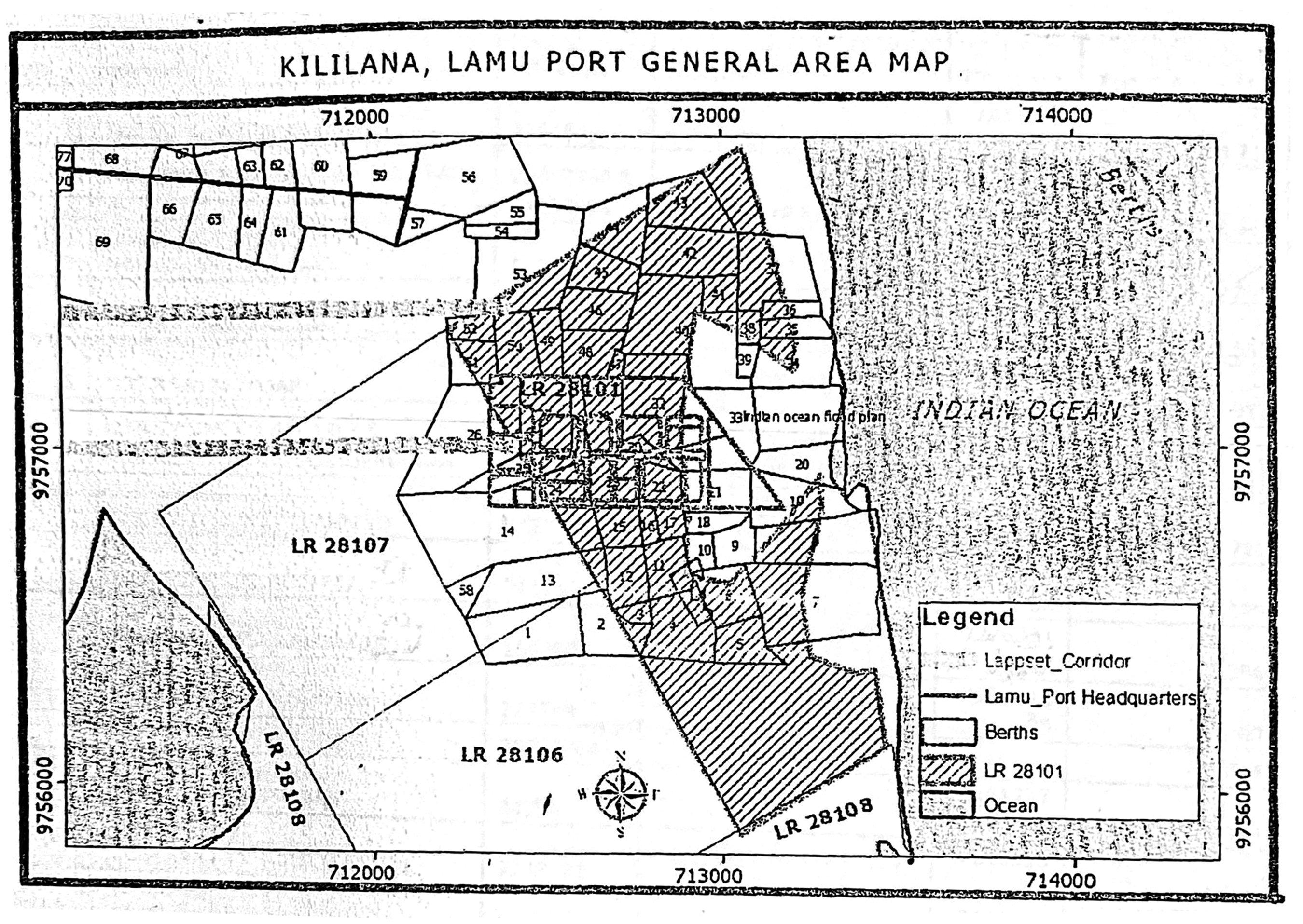
Map showing competing land claims in the process of building Lamu port (Source: Shungwaya Welfare Association records, 2021).
Community leaders are acutely aware that land is the primary way in which Lamu’s existing communities can access and benefit from LAPSSET’s promise of prosperity. In the words of Lali: “The problem is our people can’t pull themselves up. They want land, they want part of LAPSSET, they want to own it.” 48 In raising these anticipations, LAPSSET reactivates historical grievances about displacement and resettlement from the Kenyatta era. In this sense, the work of civil society organizations such as Save Lamu amounts to an unusual form of infrastructural repair: a way of redressing the past to forge another future, in this case by transforming LAPSSET’s state-mandated future. Contesting grievances is about imagining a better future for Lamu. These grievances may ultimately be shaped by a colonial past, but memory roots them in Kenya’s post-independence period.
Conclusion
In Kenya’s immediate independence era, roads, camps, allotment schemes, and other infrastructures facilitated a regime of state-led development as counter-insurgency. Historical analysis shows how these infrastructures refracted colonial relations of power. The individual and collective forms of subjectivity activated by the LAPSSET project in Lamu and Isiolo are shaped by historical experiences of this infrastructural violence. While these forms further entrench the deployment of ethnic identity as political resource, they are not only colonial or postcolonial; they are inscribed in ways of being rooted in complex histories of belonging.
Historical redress is a key mode of anticipating, and transforming, mega-infrastructure futures. This orientation is neither a tool exclusively of the weak, nor just of those in power, but rather by a range of actors that serve as mediators of community experiences and popular discontents, and in doing so, put forward alterative visions for infrastructure development. In the town of Isiolo and its surrounding region, such mediators mobilize the past in efforts to safeguard pastoralism in the fraught processes of urbanization fueled by the promises of mega-infrastructure. In Lamu, the construction of the new port, linchpin of the LAPSSET project, similarly reactivates history—through stories of ancient global belonging as well as lived memories of state violence, internal displacement, and land dispossession. Local community leaders mobilize these pasts not only to resist the LAPSSET project, but also to add new elements to its portfolio, to secure resources for local empowerment, to contest dispossession and other ongoing injustices in court, and to build local capacity and advocacy.
This article has argued that to understand Africa’s mega-infrastructure futures, scholars might do well to look at how that which is past gets thrown into the balance of the future. It is imperative that such analysis account for the experiences of colonialism and the reproduction of racialized relations of power in space and time. Yet it is just as important for scholars to avoid reproducing the worldview which such analytical interest silently carries along—a worldview in which lives and meanings are defined relative to a “colonial matrix.” At its worst, such an approach locks Africa in a conceptual straightjacket, in which people and governments are passive victims or unwitting reproducers of regime of coloniality/modernity, for which Europe ultimately holds the central historical responsibility. To foster more ethically accountable and critical accounts of coloniality in African cities and spaces, infrastructure scholars may need a different model of history. Rather than tracing how the (colonial) past shapes into the (postcolonial) present, this would entail recognizing how anticipations of an infrastructural future bring up and remake the histories that individuals and communities mobilize to partake in or transform that future. Even when the future is built on the seemingly unchanging ruins of empire, it is contested in the volatile spaces of the past.
Footnotes
Acknowledgements
This research was made possible because of collaboration with Mohammed Mchulla and Kabage Karanja from Cave Bureau (Nairobi), with whom I conducted the initial phase of this research. I also thank Mohammed Bwana, Raya Famau, Walid Ahmed, Kadija Juma, Abdulrahman Lali, Mohammed Athman, Abubakar Mohd Twalid, Hassan Shafia, Somo M. Somo, Munira Zubeir, Mohamed Ali Gololcha, Daud Tari, Hussein Isack, Hassan Roba, Abdub Mollu Ido, Jarso Mokku, and the many other interviewees who wished to remain anonymous. Many thanks to Prita Meier, Gedimanis Lesutis, Ernest Sewordor, Tania Messel, and Andrea Pollio for their incisive feedback on earlier drafts.
Declaration of conflicting interests
The author(s) declared no potential conflicts of interest with respect to the research, authorship, and/or publication of this article.
Funding
The author(s) disclosed receipt of the following financial support for the research, authorship, and/or publication of this article: This research was financially supported by the Swiss National Science Foundation (Grant: Governing through Design).