
Abstract
Accepting frameworks promulgated by the Israeli occupation, public discourse has often debated Gaza as a “problem” to be solved, treating it more like a political quandary than a concrete city. Recent scholarship on the Israeli–Palestinian conflict explicitly problematized this approach and resisted the subsumption of Gaza city into the larger geopolitical unit of the eponymous Strip. This article contributes to this new body of critical work by addressing the dispossessory dynamics stitched into Gaza’s urban fabric through an episode from its urban and architectural history. It argues that everyday issues cannot be ignored when analyzing Gaza within the colonial paradigm: indeed, under colonial conditions, these everyday issues inevitably become a site of conflict. Based on archival materials and interviews with key actors involved in the Gaza Master Plan, the article discusses Gaza as a material city with urban institutions and a cast of professional actors. The planning process reveals fundamental tensions regarding the urban status of Palestinian refugees, who became captives in the clash between Palestinian nationalism and Israeli occupation as it played out in the politics of Israeli urban and regional development.
Introduction: why Gaza?
Time and again, Gaza appears in the global media under dense clouds of fire and explosives. For many people across the world, such images epitomize the violence of Israeli occupation—a never-ending cycle of military confrontation, Palestinian resistance, siege, poverty, human misery, and destruction. These highly conspicuous forms of the occupation’s violence, however, often blot out the less ubiquitous effects of that violence—namely, the dispossessing of those cities and settlements of their urban histories. Correspondingly, many scholars have examined the city almost exclusively through the prism of the occupation and relied on settler-colonial structures of power and violence to emphasize Gaza’s subjugation to Israel, resulting in a more or less uniform scholarly gaze (Azoulay and Ophir, 2008; Gordon, 2008; Li, 2006; Lustick, 1993; Parsons and Salter, 2008; Weizman, 2007; Zureik et al., 2011). Such scholars often emphasized settler-colonial structures of power and dominance and located Gaza within a particular matrix of violence. Ultimately, this epistemological settler-colonial geopolitical and scholarly pre-conceptions deprived Gaza of its agency as a material urban entity and entrenched its image as a symbol of violence—one to fight for, or to pity, but not to accept and study as is, due to the risk of “normalizing” an abnormal situation.
In this article, we attempt to rethink Gaza through its urban and architectural history. We argue that the early Israeli occupation of Gaza cannot be fully understood as a story of Israeli-led structural ethnic cleansing and displacement of native populations (Gordon, 2008; Veracini, 2006; Wolfe, 2006). Focusing on Israel’s infrastructure development programs, we argue that they were parts of an economically driven form of colonialism (Doumani, 1995; Owen, 1982). In other words, we read Israeli policy within the (post-) colonial, modernist development discourse while attending, in turn, to the everyday life of colonial geographies. To do so, we adopt the approach to “interrogate what we think we know, urging us to explore carefully the historical production of that knowledge” (Jazeel, 2019: 1).
Presenting firsthand accounts of Gaza’s urban planning process from 1975 to 1982, stands the hitherto unpublished master plan for Gaza that the Palestinian Mayor Rashad A-Shawa commissioned from a joint Israeli–Palestinian planning team led by the Israeli Architect Eylon Meromi and the Syrian architect Saad Mohaffel. Methodologically, we approach the debates about this plan as a form of cultural politics (Alsayyad, 2011; Celik, 1997; Crane, 2011; Fuller, 2006; Prakash, 2002; Wright, 1991). In focusing on architecture, and by asking how it participates in shaping urban and national politics, we seek to depolarize colonizer and colonized, to explore the everyday encounters between actors unevenly placed on the colonial hierarchy (Avermaete et al., 2010: 11; King, 2004: 61), and explore colonial difference in the context of development (Chatterjee, 1993; Morton, 2000; Wright, 1991). The urban materiality of the colonial city, then, is inevitably a site of conflict. Choosing to conduct our historical research from within the discourse about colonial architecture of development, we treat Gaza as a concrete city where urban institutions and professional actors drew up plans and set them in motion, prompting disagreements and sometimes fierce debates about the desired form of the city’s physical development. In order to write this non-deterministic account of the encounter between Israelis and Palestinians, this paper shows that a unique assortment of primary materials is necessary.
Primary materials critical to any city’s urban history are normally preserved in public municipal archives. However, most of the relevant documents to Gaza’s case are held in Israeli military archives and are closed to the public. Gaza’s municipal archives are also inaccessible, subjected to the same violence and destruction engulfing the whole city. In our search for primary materials, we therefore turned to the main professional actors who took part in shaping Gaza’s urban, conducted numerous interviews with them, and gained access to their private archives. Their alternative voice within the Palestinian architectural history-in-conflict became a sufficiently broad basis for this historical study. They are both a way to overcome a lack of access to archives in conflict zones, and a source of knowledge driven by cross-cultural encounters. The intertwined web of these voices thus becomes, in itself, a strategy of decentering the theoretical confines imposed by the paradigm of power, a heuristic model with which to situate their perspectives, and a method of developing novel theorizations about development, professionalism, and cooperation under conditions of conflict. The findings exposed tensions between the two architects regarding the preferred solution to preserving the refugee camps, and the refugees’ right of return.
Rethinking (post-) colonial Gaza
The settler-colonial paradigm has been central to much work recently done on the Israeli–Palestinian conflict. Researchers surveyed the history of the Israeli territorial expansion and contraction (Lustick, 1993), considered its significance to Palestinians living under Israeli rule (Robinson, 2013) and debated Israel/Palestine as a variant of settler colonialism (Veracini, 2011, 2015). Veracini, for instance, relates to Israel as a settler society that had already developed through the stages of mass dispossession of indigenous Palestinians and is now progressing toward what Smith called the elaborate forms of “multicultural inclusion” (Smith, 1986 in Veracini, 2006: 2). The formative threat of elimination and its influence on indigenous life on numerous levels is central to his account, as it is to that of several other scholars (e.g. Gordon and Ram, 2016; Yazzie, 2014). Inspired by Wolfe, who famously wrote that we should relate to settler colonialism as “a structure rather than an event […] an inclusive, land-centered project that coordinates a comprehensive range of agencies, […] with a view to eliminating Indigenous societies” (2006: 402), the modalities of settler colonialism compelled such scholars to read the conflict through a binary opposition of colonizer and colonized as a process in which the former would ultimately replace the latter.
Some urbanists, historians, and social scientists have drawn on insights from urban studies to re-work the settler-colonial thesis, arguing that the way specific cities were planned and renovated can be read as power relations made explicit in the built environment. Focusing their attention on cities in conflict, and particularly on ethno-national conflicts within cities, scholars such as Dumper (2005), Hepburn, (2004), Yiftachel and Yacobi (2003), Pullan (2011) and Bollens (2000) traced uneven formations of inclusion, exclusion, and segregation that operated along social, political, economic, ethnic, national, and racial lines of division. As Yacobi suggested, these studies revealed how minorities and vulnerable people become “polarized, ghettoized and fragmented in surprisingly similar ways” across many national and cultural settings (Yacobi, 2009: 2).
What, then, were the power relations made explicit in Gaza’s built environment? Israeli policymakers considered security and military concerns to be inseparable from economic development in Gaza and tasked the urban developers to attend to both in their work on the Gaza Strip between 1967 and 1982. The Israeli masterplan for the Gaza Strip and North Sinai represented a major, government-led development project that would serve the overarching goals of generating economic and social change necessary to ensure pacification (Muzaffar, 2007; Pyla, 2013). At its core was the belief that the colonizer/developer could—and should—exercise a considerable degree of control over the fate of the colonized/developed, who were no longer an adversary but a subject undergoing a process of guided development (Escobar, 1995; Ferguson, 1990; Sachs, 1992). Historically, both traditional colonialism and Israeli settler colonialism used the same rhetoric of “apprenticeship”, “gaps”, and “development”, to blunt conceptualizations of imperialism, colonialism, and economic exploitation.
Jazeel (2019: 1) has reminded us that the study of postcolonial societies “must be partial, provisional, and attenuated to new, unthought strategies for thinking and living through and past the inequities of colonialism in the present”. Following Jazeel, we suggest looking at the actors involved in the making of colonial urbanism in Israeli occupied Gaza (King, 2004; Wright, 1991). Colonial administrations particularly sought out native elites willing to promote and advocate development in the colonies. Morton, for example, demonstrated how this cornerstone of British indirect rule inspired the association policy of French colonialism in North Africa (Morton, 2000: 186–188).
Israel similarly called upon local elites to participate in the enactment of its colonial policy. Although patronage and subordination were central to these relationships, Palestinian elites were not pawns in the hands of Israeli policymakers. They often were able to shrewdly use their power over local urban administration to pursue their own goals, Israeli desires notwithstanding. This Palestinian agency in urban planning, which stands at the heart of our current examination, mirrors the roles played by Palestinian intellectual and financial elites in other fields, who collectively played an active role in developing the Palestinian economy and forming important institutions under British and Israeli colonial rule (Doumani, 2017; Robinson, 2013; Seikaly, 1995, 2016; Tamari, 2017). A renewed focus on such native intermediaries liberates the colonized from the colonizer’s epistemological shadow and de-centers the colonizers from the epicenter of inquiry in our research monographs (Seikaly, 2016: 20). In the urban arena, it also helps us avoid echoing notions of Palestinian geography as a “stereotyped […] place of violence and suffering” or locate Palestinians within processes in which they “themselves can become discursively erased as active subjects” (Harker, 2011: 307).
Architectural and urban plans are usually a hybridized cultural product, but they often evade the dichotomization of the colonizer/colonized. This form of cultural politics is significant in understanding how the materiality of the city came about and its role in framing the experience of everyday life in it. One way to identify architecture as a form of political and cultural production is to insist that the architectural historiography of Gaza must remain in the context of its wider cultural history. Doing so demonstrates that how Gaza is more than an arena of a zero-sum colonial or nationalist struggle or of urban destruction. Though primarily led by and ultimately in the service of Israelis, it was also shaped, to a degree, by Palestinians. And it is this historical dynamic, led by these actors, that we set out to recover.
Gaza: historical background
In December 1978, Gaza’s Mayor, Rashad A-Shawa, wrote a letter to architect and town planner Saad Mohaffel, outlining the basic principles of his vision for Gaza. Writing at length, A-Shawa reviewed the city’s history from the Islamic–Arabic period to the end of the British Mandate period. Gaza’s location at the crossroads of three continents—Asia, Europe, and Africa—made it a natural trading center. The 20th-century, for him, demonstrated the continued relevance of the city to empires seeking regional domination. Although the letter addressed the events in the preceding three decades in considerable detail, A-Shawa conspicuously skipped the 26-year long period (1949–1975) when Gaza was trapped within the confines of the Strip. Noticeable, too, was his lack of any mention of Egyptian President Gamal Abdel Nasser’s plan to build of a modern port and central power station in Gaza. 1
A-Shawa’s pro-Jordanian politics (Butt, 1995: 158; Filiu, 2014: 110, 148–149) may have been at play here. His emphasis on the city’s perseverance in the face of numerous imperial projects throughout its cosmopolitan history flew in the face of the idea of annexation by Egypt, an idea popular at the time among pro-Egyptian leaning notables in the city. A-Shawa did write about his father, Said A-Shawa, Gaza’s last mayor in the Ottoman period, hailing the strides he made toward founding some of the city’s major urban institutions. He also approvingly recounted his elder brother’s tenure as mayor from 1939 to 1951, under whose watch the city’s economy flourished, particularly following an expansion of its port facilities.
Given the historical development of the city, A-Shawa’s focus on developing the port seems understandable. In Ottoman times, Gaza was the capital of a sanjak (district) within the mutasarrifate (province) of Jerusalem. The Old city of Gaza never was as a port city like its Mediterranean neighbors. The high profitability of the barely trade, as Halevy (2015) explained, shrank the diversity of its economic activity, with local production mainly focusing on the export of a single cash crop. As a result, both the Ottoman government and the British empire were not quick to adopt the idea of making binding long-term investments in Gaza.
The reasons for the prolonged absence of a port in Gaza go beyond the scope of this paper. However, it may be connected, as Norris (2013) explains in the context of the British developing the port in Haifa, to a wider history of trade, empire, and colonialism, where competition between Britain and France over control and access to natural resources in the Eastern Mediterranean seaboard channeled interest into particular locations, to the exclusion of others. Gaza only became a port city under the British. British development efforts saw the road from the Old City to the port as the new city’s main economic artery (Efrat, 1984: 205; Halevy, 2015: 87), attracting a new merchant class to a new neighborhood, Rimal, built next to the port and to the west of the Old City.
This period of accelerated growth ended when Gaza lost access to most of its agricultural hinterlands during the Nakba, striking a crippling blow to its barley exports. Egyptian plans to develop the port were drawn up in the mid-1960s under Gamal Abdel Nasser but were never realized due to the 1967s war. Initially, the Israeli government did not plan to make any investments in the port of Gaza. At length, Israel decided to build a new port in an all-Jewish settlement, “Yamit”, to the south of the Strip, in a move that would effectively relegate Gaza to the role of a cheap source of labor to its Jews-only neighboring port town. The logic of the planners followed the geography of the Mediterranean coast: “the distance between Yamit and Port Said”, they wrote, “resembles the distance between Lebanon and Haifa”. 2 A new port at Yamit, they surmised, would be economically feasible.
In 1971, the Israeli administration appointed A-Shawa as a mayor, because, unlike the scions of other major families in Gaza, his public profile did not emanate from his involvement in the resistance to the occupation, but rather, from his success as a businessman. During the British Mandate, the young A-Shawa was among the “Men of Capital” who positioned themselves in the context of broader Palestinian national nahda (renaissance) and avoided direct confrontation with the colonizers, to keep their power (Seikaly, 2016: 407). This is also illustrated in his belief that modernization could “restore Gaza its former glory and its proper place among other cosmopolitan cities”. 3 Achieving modernizations in occupied city, however, meant that A-Shawa’s ability to realize his priorities was severely limited. In 1969, he founded the Benevolent Society that promoted social welfare and constructed public institutions throughout the Gaza Strip (Filiu, 2014: 149). While A-Shawa’s first term as a mayor lasted only a single year, his second term lasted seven years, from 1975 until 1982. However, his influence did not depend solely from the power of his office. Rather, his Benevolent Society made his voice a constant in the affairs of managing the city’s public life.
Development under Israeli occupation
The letter A-Shawa sent to Mohaffel was, above all, a call to action. A copy of the letter opens the meticulously prepared “Gaza Master Plan” (al-Mokhatat el-Haykali la Madenat Gaza), which A-Shawa commissioned for the city. The impressive 80-plus-page master plan translates the historical imaginary of the city and its developmental aspirations into a planning prospectus detailing land uses, structural layouts, institutional distribution, and preservation policies. Each section opens with a photograph depicting the city’s glorious past and goes on to feature detailed statistics, graphs, and various technical maps.
That the plan was an attempt to strike a middle line between preservation and development is evident even from the image chosen to adorn its cover: a reprint of an etching by the Scottish traveler and artist David Roberts from 1839 (Figure 1). Roberts depicts Ottoman Gaza behind the archaeological ruins of an imperial ancient city, which he places in the foreground. This image provokes the representation of the challenges of “Gaza Master Plan”, which seek to address the way to bridge the gap between the different temporalities of the city: its past, present, and future. The architects were asked to work within the context of colonial development to link native Gazans to their past. Additionally, they were asked to lay the foundations for future development, while also attending to the present demand to serve native Gazans only, and not the many refugees occupying the temporary refugee camps at the city’s outskirts. Their task was to sustain Gazans’ sense of belonging to their city place by adhering to the division between locals and refugees set out by Palestinian nationalism that was most forcefully encapsulated in the partition between the city itself and the adjacent Al-Shati refugee camp. The camp embodied the state of crisis that the nationalist vision sought to resolve; it concretized the urgency of the struggle for Palestinian liberation and the continued demand that the universally recognized right of refugees to return to their homes be respected.
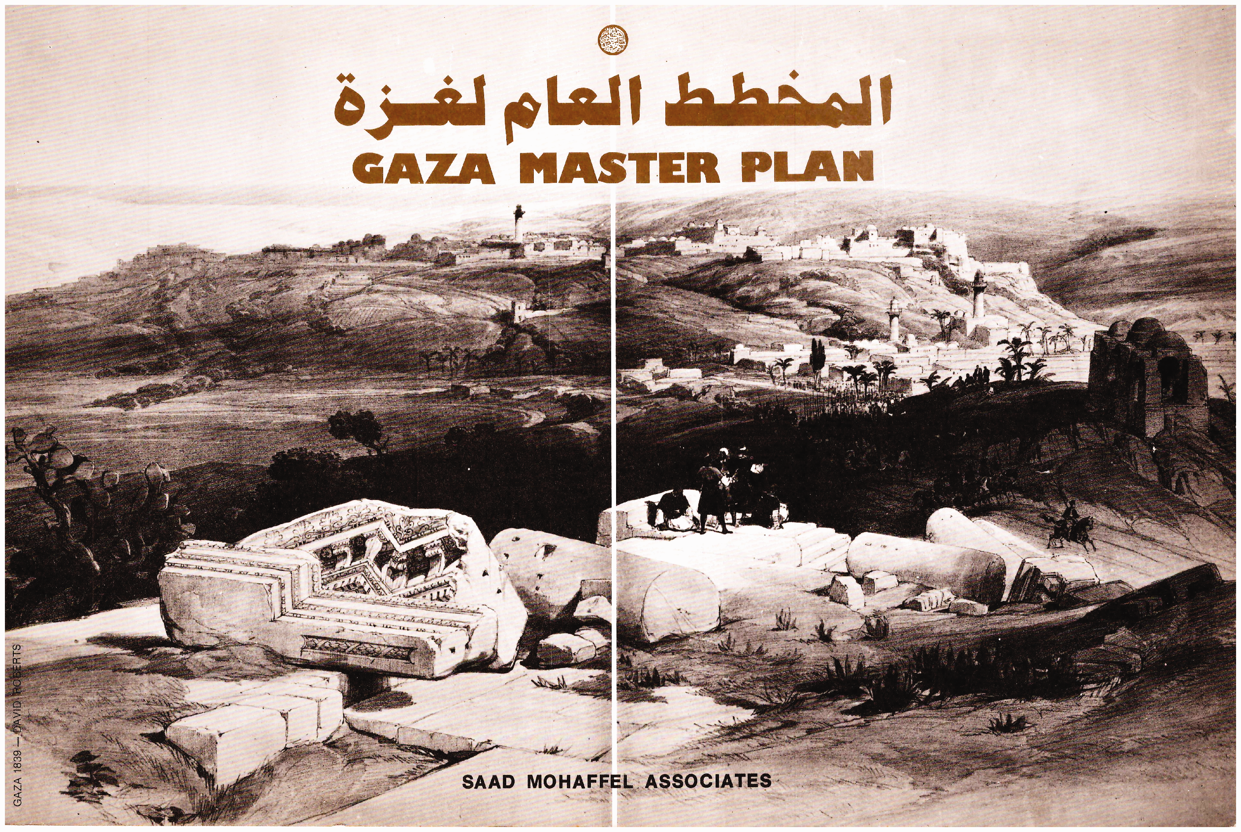
A reprint of an etching of David Roberts (from the booklet of the Gaza Master Plan, Eylon Meromi’s private collection).
A specific challenge that A-Shawa posed to the planners was the development of the beach area. A-Shawa wanted to create a recreational promenade that would connect the port compound to the well-to-do Rimal neighborhood. 4 The Al-Shati refugee camp, however, was located on the beach between the two locations (Figure 2). How could the plan be executed without demolishing, at least in part, the refugee camp that he considered ex-territorial to the Gaza civic body? A-Shawa commissioned Mohaffel to head the planning team that included Israeli experts whom architect Eylon Meromi assembled for the task.
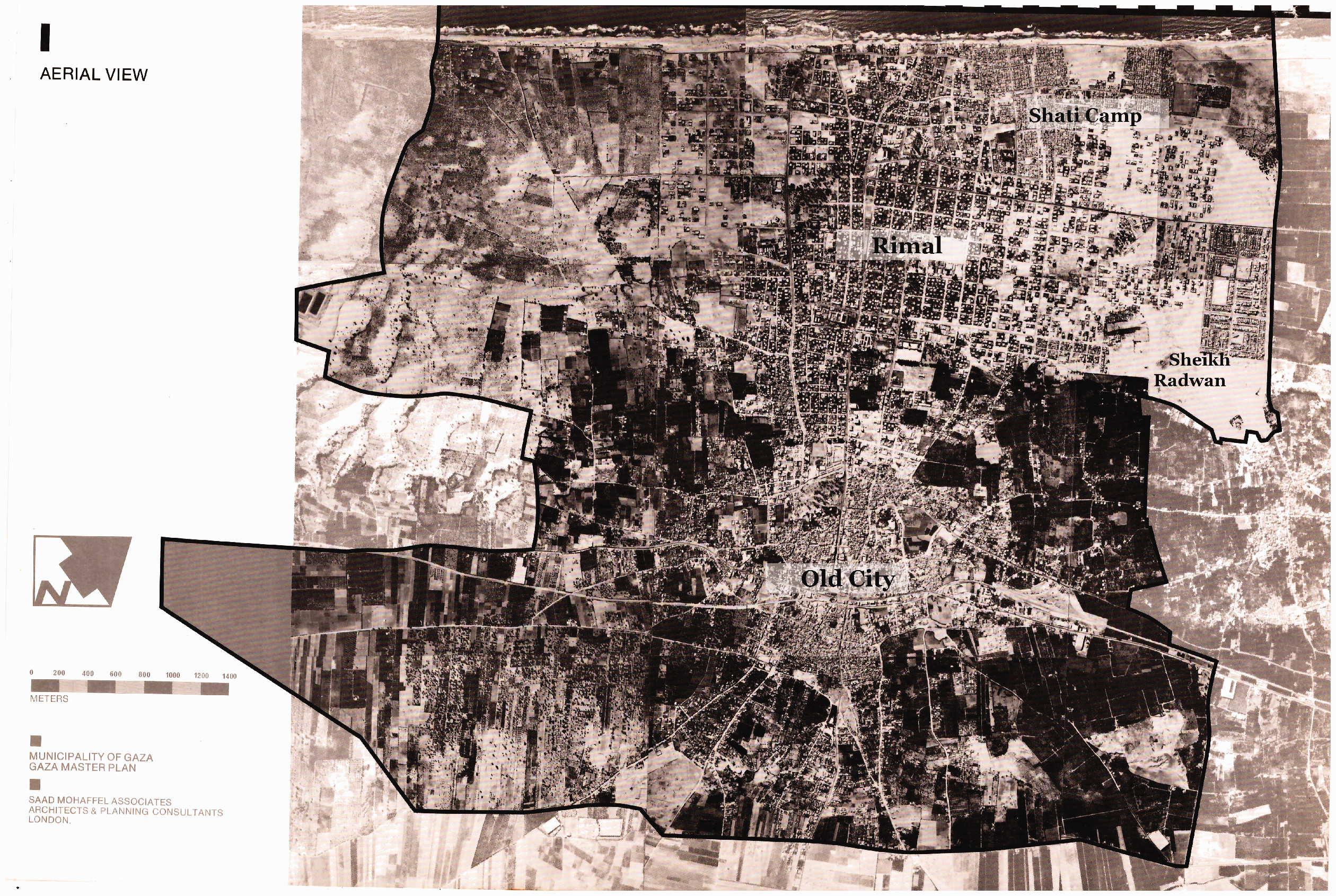
Aerial photograph of Gaza City, 1978 (from the booklet of the Gaza Master Plan, Eylon Meromi’s private collection, English names by the author).
Meromi completed his studies at the Technion—Israel Institute of Technology in 1972. After graduation, he joined the office of architect Dan Eitan and supervised a high-rise housing complex that Eitan was commissioned to design in Iran, then an Israeli ally (Feniger and Kallus, 2013). The project’s principal customer was the Iranian Navy in Bandar Abbas and Bushehr—two historical port cities—and on the island of Kharg. A-Shawa’s proposal was, therefore, an exceptional opportunity. 5
A-Shawa’s son-in-law, Mohaffel, was born in Syria in 1940. He studied during the 1960s in the Tropical Department of the prestigious Architectural Association School of Architecture in London under the supervision of architect Otto Koenigsberger. 6 The latter, a former United Nations technical aid advisor, encouraged his students to turn to Singapore’s urban renewal as a model and an inspiration. Mohaffel was inspired by Koenigsberger to help develop planning solutions for overcrowded cities adapted to the local culture. 7 Equipped with technical and climatic knowledge, with a sensitivity to local culture, Mohaffel took projects in several Middle Eastern cities, including Gaza. In 1972, while working on a feasibility estimate for a hotel in Yemen for the International Investment Bank in Beirut, Mohaffel met the mayor’s daughter, the painter Laila A-Shawa. 8 She shared her father’s vision to develop Gaza and introduced Mohaffel to her father. The mayor decided to entrust Mohaffel with drawing up plans for the city.
According to Laila A-Shawa, the collaboration between the Arab and Israeli architects was forced upon them by the context of the occupation. She argues that her father realized that fulfilling his great ambitions for the economic and cultural development of the city depended on employing the Israeli architects “suggested” by the Israeli military administration. 9 Meromi, on the other hand, insisted that no coercion was involved. Mohaffel did not specialize in town planning, he claimed, and as a result, his overall impact was limited. The one who did seem to push things forward and made herself involved in the details of the plan was Laila A-Shawa, whom he recalled was “a strong woman with an acute political consciousness, who participated in almost all planning sessions”. 10
Mohaffel’s approach to town planning was very different from Meromi’s. Mohaffel emphasized affinities to local culture and was intimately knowledgeable of it. Meromi believed in modernist urban planning solutions and relied on his team member, Ilan Shaham, for historical research and planning coordination. Meromi and Shaham both approached urban renewal from an essentially economic point of view, relying on demographical and statistical data as key determinants in making decisions. In this regard, Mohaffel agreed, the Israelis’ preparations were very thorough. 11 Their different approaches draw on their own professional attitudes, their cultural dispositions, and a particular set of professional tools to wield architectural planning as a highly political form of cultural production (King, 2004; Wright, 1991).
Work on the masterplan of Gaza did not only bring together two sides of a political conflict, but also two conflicting professional approaches. The first, a master architect with an ideology of situated modernism, committed to place and to disciplinary memory. The second, an institutional architect who espoused developmental modernism driven toward progress, stood in opposition to each other. 12 Did Mohaffel attempt to cater to the city of Gaza as a definite historical and cultural place (Harker, 2011) at the expense of the broader geopolitical reality? Was it Meromi’s conscious intention to fortify the new borders of Israel through such developmental colonial programs (Fuller, 2006) and use his involvement in drawing up the masterplan in order to promote Israel’s policy goals in the area? How can an architecture so replete with myriad technocratic and cultural approaches, operative tools, and a planning team divided along two such starkly different approaches to the city, meet A-Shawa’s expectations to reshape Gaza as normative port city, the presence of Israeli occupation and its interests notwithstanding?
Creating the new: negotiating modernization
The architects submitted the final master plan in two languages—Arabic and English. An intriguing pattern emerges throughout. From one side, the plan highlighted where they agreed and from the other side it underplayed their differences. For instance, they criticized the approaches to urban renewal that were based on demolition and erasure. Additionally, they explicitly expressed their wish to utilize their plan to help ameliorating, rather than eliminating, the city’s complexities. 13 But they could not agree about what urban “improvement” consisted of or what desirable social engineering they hoped to achieve. They presented a coordinated approach to the reorganization of the city as part of the region, but their notions of regional boundaries were different.
In the comprehensive plan they prepared for the development of Gaza until the year 2010, both architects considered the first two “Gazas”—the earlier Ottoman and later British—as a singular “old center” quarter. This core they contrasted with the “third Gaza”—new urban quarters that their plan would propose as satellite neighborhoods around the old center (Figure 3). The plan indicated that the new neighborhoods would rely on an integrated street system, which combines the two existing systems of the Ottoman radial streets and the Mandatory grid streets. The plan proposed to build one neighborhood to the west of the ancient city, to the south of Rimal. As fishermen’s neighborhood, it would be naturally inclined toward a later emergence as a leisure and touristic area. 14 Another satellite neighborhood was planned on an area of 250 hectares were stood in the Al-Shati refugee camp. Two additional satellite neighborhoods were also planned. The first is adjacent to the A-Tufah neighborhood southwest of the Old City, which connect to the main north-south artery, Salah al-Din Road. The other one, designated for high-density residential construction, was built in the southeast. Both of these neighborhood were to be built primarily on citrus groves owned by the A-Shawa family. 15 The plan separated Old Gaza (the Ottoman and Mandatory-era neighborhoods) from the new satellite neighborhoods by a green belt—an area located in between the city’s two main thoroughfares, Omar al-Mukhtar and al-Wihdi. 16
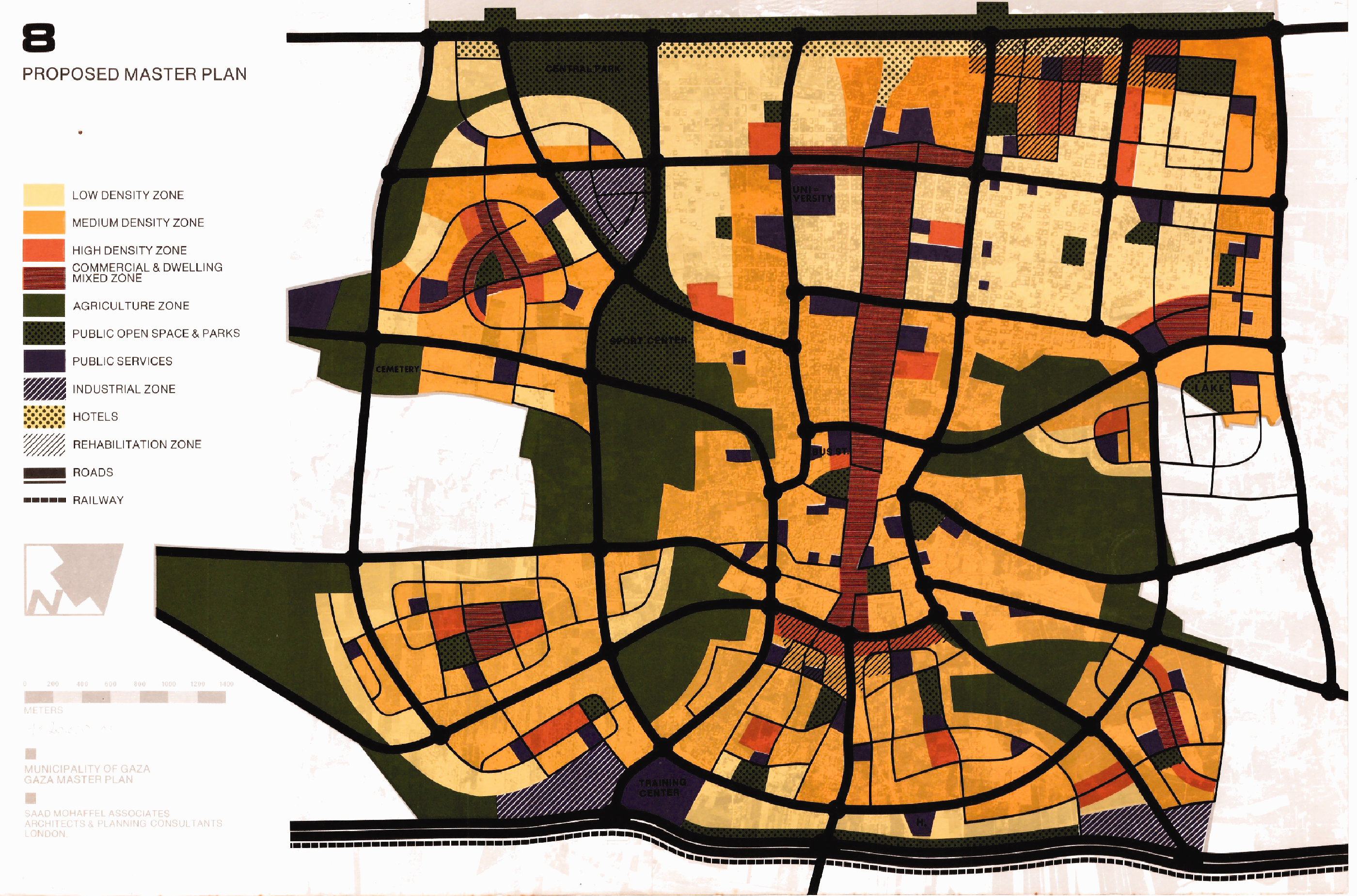
Proposed Master Plan for Gaza (from the booklet of the Gaza Master Plan, Eylon Meromi’s private collection).
Each architect saw the green belt’s role differently. Meromi considered the system of satellite neighborhoods crucial to developing the new city. He considered the existing areas of tiny, narrow interlaced streets an obstacle for any future development. Additionally, he insisted that the city could not be developed on the basis of its current dilapidated infrastructure. Vast open areas, a tabula rasa, were necessary to do so. The citrus groves were the only land that could lend itself to such a realization. The green belt was thus, in Meromi’s mind, a buffer zone of parks and leisure areas that could contribute to the old quarter’s residents’ future quality of life and an essential buffer between the old city and the new. 17
Mohaffel, by contrast, saw the implementation of the green belt on a broader regional scale. He was inspired by the famous green belt around London, which created a buffer zone around the city and limited the expansion of the towns around it. This buffer also presented an administrative border where control would be maintained through construction and conservation regulations. The satellite neighborhoods that were developed beyond the belt were often defined as commuter towns that retained a link to the metropole. Since Mohaffel recognized the potential of historical Gaza to serve as the major commercial urban center for the entire Strip, he considered the green belt as an ideal boundary maker for the city. 18
The most charged disagreement between the two architects was regarding the Al-Shati refugee camp. Meromi did not consider the camp an obstacle. The real limitation for him was the over-crowdedness of both the camp and the city, even at the time one of the most densely populated urban areas in the world. Despite the temporariness of the occupation, his plan catered the original inhabitants, took their natural growth into account, and, also, addressed the needs of refugees who were living within the city limits. The plan was designated to provide both groups with a viable solution for the next three decades, until 2010. What Meromi’s plan effectively meant was that refugees would be irreversibly integrated into the city’s landscape and urban environment. 19
Meromi’s approach would effectively undermine the carefully observed political distinctions between the A-Shati camp and the city, which were cardinal to the demand to realize the refugees’ right of return. His plan promised refugees equality on the municipal level, which advances an ethical cause, de facto at the cost of their right of return. In doing so, it aligned with the interests of the Israeli occupation and echoed its geopolitical solutions to the area. But it also allowed him to simultaneously espouse an architecture committed to the values of civic equality and humanitarianism and lay the groundwork for Israeli policies of regional economic development. The distinction between the camp and the city has been the main focus of several researchers who explored the agency of the refugees in spatial materialisation of the city (Hanafi and Long, 2010; Katz et al., 2018; Sanyal, 2014). But, as this article reveals, this agency was given to architects and state professionals to draw the spatial and national lines between the camp and the city. Meromi’s architectural point of view cannot be separated from the objectives of Israeli settler colonialism played out in the unique socio-urban fabric of Gaza. Ensuring equal urban citizenship rights for Palestinian refugees was an occupation policy masquerading as a form of humanitarian aid. The long-term political goal of the Israeli masterplan for the Gaza Strip and Northern Sinai was to use development to solve the refugee problem by eliminating the difference between refugee and city-dweller and anchor the former to their assigned cities in the Strip by creating new jobs and new homes (Abreek-Zubiedat and Nitzan-Shiftan, 2020). This, too, was the context in which Yamit was developed as a port town in the southwestern outskirts of Rafah—it was to be the future economic engine of the area, an all-Jewish colonial “New-Gaza”.
Mohaffel believed that the camps had to be demolished before development projects could begin in the city. Unlike Meromi, however, he did not wish to integrate the refugees into the urban fabric of Gaza; his idea was to provide a short-term solution that would allow him the necessary flexibility develop and reorganize the city. Ultimately, he considered the refugees—city’s de facto population—as necessarily temporary residents. For Mohaffel, the refugee problem was supposed to be resolved in the context of a regional, or national, plan. Thus, although both agreed that the Al-Shati camp had to be destroyed in order to develop Gaza as a coastal port city, they differed about the extent and ultimate goals of the refugees’ relocation. 20
Representatives from the Gaza Association of Engineers and Architects and Laila A-Shawa, who was present in the meetings and took an active part in the discussions, vehemently opposed the plans to relocate refugees in the high-rise building option. Mohaffel claimed that he was willing to negotiate the high-rise concept. The locals interpreted Meromi’s insistence on high-rise residential solution as a possible first step toward an Israeli plan to permanently settle the refugees in Gaza and prevent their return to sovereign Israel. According to Laila A-Shawa, one of the main alternatives Meromi proposed was the construction of nearly 170 twenty-story apartment buildings on her father’s lands—14 hectares of citrus groves. Meromi independently tried to persuade mayor A-Shawa to publicly endorse this idea in order to encourage Gazans to warm up to the idea and capitalize on the carrot of development. He also tried to propose the same spatial terminology for the camp itself, a move that was diametrically opposed to the A-Shawas’ and Mohaffel’s views and principles. 21
Meromi interpreted A-Shawa’s opposition to his plan as a reluctance to surrender a family asset for the greater good. Meromi saw their demand to build residential buildings according to the local architectural model—low-rise family units—as an evasive counter proposition meant only to stave off his own, feasible, solution. Meromi further believed that Gazans feared competition from A-Shati’s refugees, who, if given the chance he was offering them, would be in a position to start competing with them over political and professional positions across the city. He insists that, unlike the A-Shawas’ plan, his proposed interventions were apolitical: none of the Israeli authorities intervened in their deliberations and in his proposals, after all. He had no stake in the matter; he planned only what he believed to be the best possible solution for both Gazans and refugees in that given time and place. 22
Informed of his former colleague’s arguments, Mohaffel wondered: If Meromi’s approach was truly to plan for the Gazans, why did he insist on the antisocial solution of high-rise apartment blocks? Why plan similar residential buildings for locals and for refugees, whose presence in Gaza was, after all, temporary? “I never had the opportunity to learn from Eylon” Mohaffel said, whether some of the ideas we used to discuss were coming from political expediency or architectural experience. Eylon and his team had the job of dealing with the political side of things and liaise with the planners of the Gaza Strip Master Plan, which was in the process of being produced when we began the study.
23
Facing sea or land?
How did the interface between architecture and politics play out on the ground? Mohaffel claims that he and A-Shawa demanded to see the Israeli regional master plan several times but was rebuked by the Israeli planning authorities.
24
A-Shawa then asked Meromi, who liaised between the local and the regional planning teams, to try and find out why Israeli authorities would not permit the construction of a port in the city. Meromi contacted Israeli officials and transportation consultants who explained to him that a commercial deep-water port could not be built, given the existing urban waterfront: the ideal location for such a port would be in the open areas to the south of the city.
25
Meromi claims that he had realized that Israel was resolved not to turn Gaza into a serious port city. In his own words, he understood that Israel wanted “a port for Gaza rather than a port in Gaza”: the idea was to build it in the Israeli settlement of Yamit.
26
Shimon Peres, then the Israeli Minister of Defense, described the conflict in terms of contradictory political meanings embodied by Gaza and Yamit: We realized that instead of clashing with the Arabs, we should focus our efforts on the wilderness. For us, Yamit’s architecture was a way of subjugating the wilderness […] And even that agitated the conflict because the Arabs did not want us there. So we proceeded in two prongs simultaneously: one was to appease the Palestinians through [improving Gaza’s] streets, and the other (Yamit) was to ensure our strength—two different perspectives.
27
The implications of Peres’ decision to boost developing economies through humanitarian aid (Escobar, 1995; Muzaffar, 2007; Sachs, 1992) are recorded in contemporary correspondences between Israeli governmental and developmental bodies. These illustrated a policy guided by a strategy of involvement rather than one of assimilation: by raising Palestinians’ standard of living in their own places instead of assimilating them in Jewish settlement, the aim was to forge long-term ties with Palestinians in the Gaza Strip while keeping them at arm’s length. Israel understood its political and economic interests as absorbing the Palestinian territories into the Israeli economy, exploiting Palestinians’ labor and making Palestinian markets accessible to Israeli firms, all while preserving the principle of separation. 28 This approach is inconsistent with the fundamental premises of settler-colonial theory as articulated by Cavanagh and Veracini (2017): these interventions were not simply designed to eliminate the Palestinian population, but, rather, to forge a system of exploitation based on involvement and association alongside spatial separation along racial lines (Morton, 2000), not one based on outright replacement and erasure. Wright’s notion of “colonial urbanism” (1991: 6) is thus key to understanding how local populations were subjugated in development projects where they played an active part, with prominent members of the colonized collaborating with planning schemes promoting distinctions between supposedly developed colonizers and primitive natives (Mitchell, 2002; Moon, 2007; Scott, 1998). This resonates more closely with Peres’ argument: the Palestinians would benefit from the Israeli development project but would always be dependent on a dominant Israeli system.
Meromi strove to develop Gaza and raise its residents’ standard of living within this framework. Mohaffel, for his part, concluded that without access to the general master plan for the entire Strip, his ideas regarding what had to be done about resettling the refugees or building the commercial deep-water port were futile. 29 He decided therefore to redirect his efforts to preserve and enhance the authentic architecture of Ottoman Gaza. 30 Mohaffel saw in the master plan an opportunity to devise a comprehensive preservation policy and estimated that the budgets and authorizations at his disposal permitted him to appoint a team of architects who would prepare a detailed record with precise measurements of every building of historical value for the purpose. 31
When Mohaffel’s team submitted their plan for A-Shawa’s review in late 1978, however, their efforts were met with the mayor’s disapproval. In his anger, A-Shawa accused his son-in-law of allowing himself to be manipulated by the Israelis and to do nothing substantive to improve Gazan residents’ economic situation or help the refugees. Laila A-Shawa concurred with her father’s accusation of her husband, noting that, despite Mohaffel’s obvious talents as an architect, he lacked the political acumen to combat the incessant Israeli efforts to forcibly assimilate the refugees and to insist that a deep-water commercial port be built in Gaza, not elsewhere. “Gaza”, she says, “brought us together, and Gaza tore us apart”. 32
Israel not only persisted in curtailing A-Shawa’s authority but also began promoting plans to develop Jewish settlements within the Strip and around the city itself. In December 1981, it established the so-called “Civil Administration of Gaza”. By transferring Gaza’s administration from the Ministry of Defense to the Ministry of Interior, Israel subjected the civilian population to its direct rule, further eroding A-Shawa’s position. Following several months of ceaseless confrontations with the Civil Administration, A-Shawa was finally dismissed from his position in 1982.
Conclusion: between the city and the sea
This study retells one of many yet untold episodes in the history of Gaza city and its architecture. In this endeavor, we examined the masterplan that aimed to put Gaza city on the fast track to modernization, not only as a product of unusual collaboration between two talented architects, but also as a cypher between two different professional approaches. Israeli architect Eylon Meromi’s approach to the city was instrumental, future-bound: his stated aims were to improve the living conditions of all the city’s residents. His developmental approach informed his attempt to include the refugees of the Strip as equal urban residents within the boundaries of the city. By contrast, Syrian architect Saad Mohaffel skirted many of these thorny issues by directing his efforts to modernize Gaza through a commitment to respecting its past and preserving the architectural identity of its old neighborhoods in order to restore its heritage. He did not want to preserve the camps because they were essentially temporary and, to him, were not part of the city but belonged to a Palestinian space suspended in time. Professional spatial considerations, however, called for the destruction of the camp. Mohaffel’s compromise was to raze the physical camp, but to preserve the civic distinction between its residents and native Gazans by other means.
A-Shawa, for his part, feared that demolishing the camp would threaten both the integrity of Gaza for Gazans and the principles of national Palestinian struggle. A-Shawa’s vision for developing Gaza as a port city did not include the refugees, despite their de facto integration in the city’s everyday economic and social fabric. A-Shawa exemplifies the active role of key elite figures who wished to influence colonial power. He willingly participated in an uneven collaboration with Israeli rule but resented what he considered attempts to subordinate him and explicitly presented his initiatives for the city’s economic future as a step toward national independence (Doumani, 2017; Seikaly, 2016; Tamari, 2017).
Paradoxically, it was the Israeli plan that secured the employment of many refugees in Yamit, the new port city Israel designated to become the region’s chief economic engine. The Israeli settler colonialism did develop the colonized, but only insofar as they supplied cheap labor for construction projects designed to establish a long-term relationship of economic exploitation and spatial segregation along racial lines. Israeli development was thus motivated by economic exploitation, but it economically sustained the colonized nonetheless. This situation ended with when the Israeli–Egyptian peace process put an abrupt end to Israel’s long-term developmental interests in the Strip.
Prevailing analyses of Gaza’s urban space through the modalities of settler colonialism reveal the ways in which economic planning is dependent on the agency of the colonized despite their subaltern position. The different positionalities of those actors, who collaborated to create an often overlooked episode of Gaza’s architectural history, thus map out a network of actors that aligns only partially with colonial dichotomies. Instead, we render the materiality of Gaza as a product of contested negotiation between several leading professional and political actors, both Israelis and Arabs, who together formed a development network. At the heart of the struggle stood the refugees, who, both themselves and their domestic spaces, the camps, were rendered political bargaining chips in the politics of development. The study of colonial architecture and urbanism shows us the ubiquity of the duress of colonial relationships. The postcolonial researchers’ task, then, is not simply to contest the hegemonic message of history, but also to engage the medium of narrativity itself, “to reinscribe the ‘rhetoric’” (White, 1982: 20) of historical representation.
Gaza and its residents did not live to see A-Shawa’s plans realized. The Israeli designs for the Gaza Strip were abruptly abolished after the signing of the Israeli–Egyptian peace accords. Yet, the designs that Mohaffel made to protect the built heritage of Gaza may still potentially help extract the city from its contemporary one-dimensional portrayal as a symbol. The buildings of Gaza are being destroyed on a regular basis; its architectural heritage is constantly under threat. But the concretization of history that A-Shawa and Mohaffel promoted transcends these threats. This history belongs to the Gazans. It can never be occupied.
Footnotes
Acknowledgements
We are grateful for the valuable material provided by our interviewees, especially by architects Saad Mohaffel, Eylon Meromi, and by the artist Laila A-Shawa, who shared with us their personal memories and archives. We are grateful to Society and Space editor Alexander Vasudevan and the anonymous reviewers for their insightful comments and thoughtful feedback on our paper.
Declaration of conflicting interests
The author(s) declared no potential conflicts of interest with respect to the research, authorship, and/or publication of this article.
Funding
The author(s) received no financial support for the research, authorship, and/or publication of this article.