
Abstract
The ‘peace-walls’ of Belfast represent a widely acknowledged architectural legacy of the Troubles, the period between 1969 and 1994 when sectarian conflict in Northern Ireland was most extreme. This paper reveals a further crucial but unacknowledged architectural legacy. It is a Hidden City of unassuming inner-city architecture where everyday pervasiveness masks a capacity to perpetuate conflict-era forces in a post-conflict city. The first half of the paper presents a Foucauldian analysis of declassified government documents revealing the knowledge created through undisclosed systems of power-relations. Here a problematisation of accepted norms reassesses the Troubles-era urban landscape and exposes the latent significance of its socio-material complexity. The second half of the paper illustrates the material consequences of related hidden policy practices on the contemporary post-conflict community. It borrows from Goffman to offer an exposition of the institutionalisation of movement and meaning at play in the Hidden City. A triangulation of interviews, photography and architectural fieldwork is used to theorise the Material Event, a construction of meaning derived from the interaction between people, architecture and the wider systems of power-relations. The paper concludes by demonstrating the complexity of the systemic challenges posed by the Material Events and how these help constrain conflict-transformation practices.
Introduction
Calvino (1997) wrote of the Invisible Cities. This mystical collection of narratives discussed what was in fact the real city of Venice. Yet through a corpus of imaginative tales Venice is also at once the city of Zirma, of Armilla, of Baucis, of Moriana and of Argia (to name but a few). This fictional association is a deliberate provocation to establish the challenge inherent in conducting an examination of architecture created, transformed and destroyed by conflict. Calvino’s fables are evoked through fictive rendering of myth and legend where the application of meaning is at the behest of the storyteller. The capacity for alternate (and perhaps equally valid) descriptions of architecture prompts an interesting consideration as to whether these tales were works of the imagination or, rather, adroit interpretations of Venice manifest in its bricks, stones, mortar, water and earth. In this sense, a conceptual connection can be drawn with the city of Belfast. Like Calvino’s Invisible City, this paper theorises Belfast as a Hidden City enjoying competing-conflicting interpretations of its architecture that camouflage its full quintessence and ultimate importance. Viewed through the emotive lens of a city emerging from ‘the Troubles’ which raged between 1969 and 1994, these discussions pertain to the imaging (not imagining) of architecture as something other than what it first might appear to be, or perhaps, something different altogether.
The bricks and mortar of conflict
Belfast enjoys an extended literature in urban policy, environmental planning and human geography, (for example, Bollens, 1999, 2000; Calme and Charlesworth, 2008; Gaffikin and Morrissey, 2011; Graham, 2008; Shirlow, 2006) and in the more specialist fields of housing, sectarianism and segregation (see Boal, 1969; Hepburn, 1996; Jones, 1960; Monaghan and Shirlow, 2011; Shirlow and Murtagh, 2006). This paper presents original research that extends these literatures through a critical consideration of the tactical use of everyday residential architecture for the purposes of improving security and reducing terrorist threat (Weizman, 2006, 2007, 2012; Weizman and Segal, 2003). The passing of ‘emergency provisions’ legislation in 1969 as part of a wider counterinsurgency strategy (Edwards, 2010) allowed Northern Ireland’s Security Forces 1 to bypass normal statutory processes when threat to public safety was deemed especially urgent. This ushered forth a plethora of highly conspicuous militarised architecture that did not require conventional approvals. Hilltop observation towers (Wylie, 2007), bunker-like checkpoint posts, fortified police station blast-walls, steel barricades around the commercial centre of Belfast (Brown, 1985), and of course, the ‘peace-walls’, are some particularly recognisable examples. The Hidden City is a less discernable form of conflict-architecture. It is the seemingly benign, everyday architecture of cul-de-sac housing, dead-end roads, footpaths and landscaping created between 1978 and 1985 during a programme of comprehensive social-housing redevelopment. Despite protestations of purely social and environmental goals for this redevelopment there remains much conjecture that the transformation of a permeable gridiron of Victorian terraces into a patchwork of dead-end streets deliberately limited pedestrian and vehicular movement in response to paramilitary networks operating within inner-city communities. The use of cul-de-sac and courtyard residential design was, however, widespread across the UK and has commonly been associated with crime-prevention and the social sequestration of inner-city communities (Brantingham and Brantingham, 1993; Katyal, 2002). The question of interest therefore guiding this research is what is the hidden role that this everyday architecture plays within Belfast in activating and perpetuating these Troubles-era assumptions within the post-Troubles era?
The imposition of a regime of architectural change upon those lacking the private property rights or political capital to contest it is, at its core, a study of how such architecture sits at the intersection between ‘top-down’ systems of thought and ‘bottom-up’ everyday societal interaction (Hacking, 2004). The paper is therefore conceived in two parts exploring a theoretical domain where a Foucauldian view of power-relations shares common ground with a Goffmanian concern for the institutionalising effects of the architecture they create (Jensen, 2006). The first part problematises the assumed link between military objectives and social-housing design in Belfast. An analysis of previously undisclosed government files reveals the complex discursive interplay of political, military, economic and ideological power-relations (Mann, 1984, 2006, 2012) that provided subterfuge for secret security-focused architectural practices. In doing so the paper reveals the special meaning attributed to the everyday inner-city road and dwelling in Belfast and outlines hidden historical policy biases which continue to shape the urban fabric of inner-city communities.
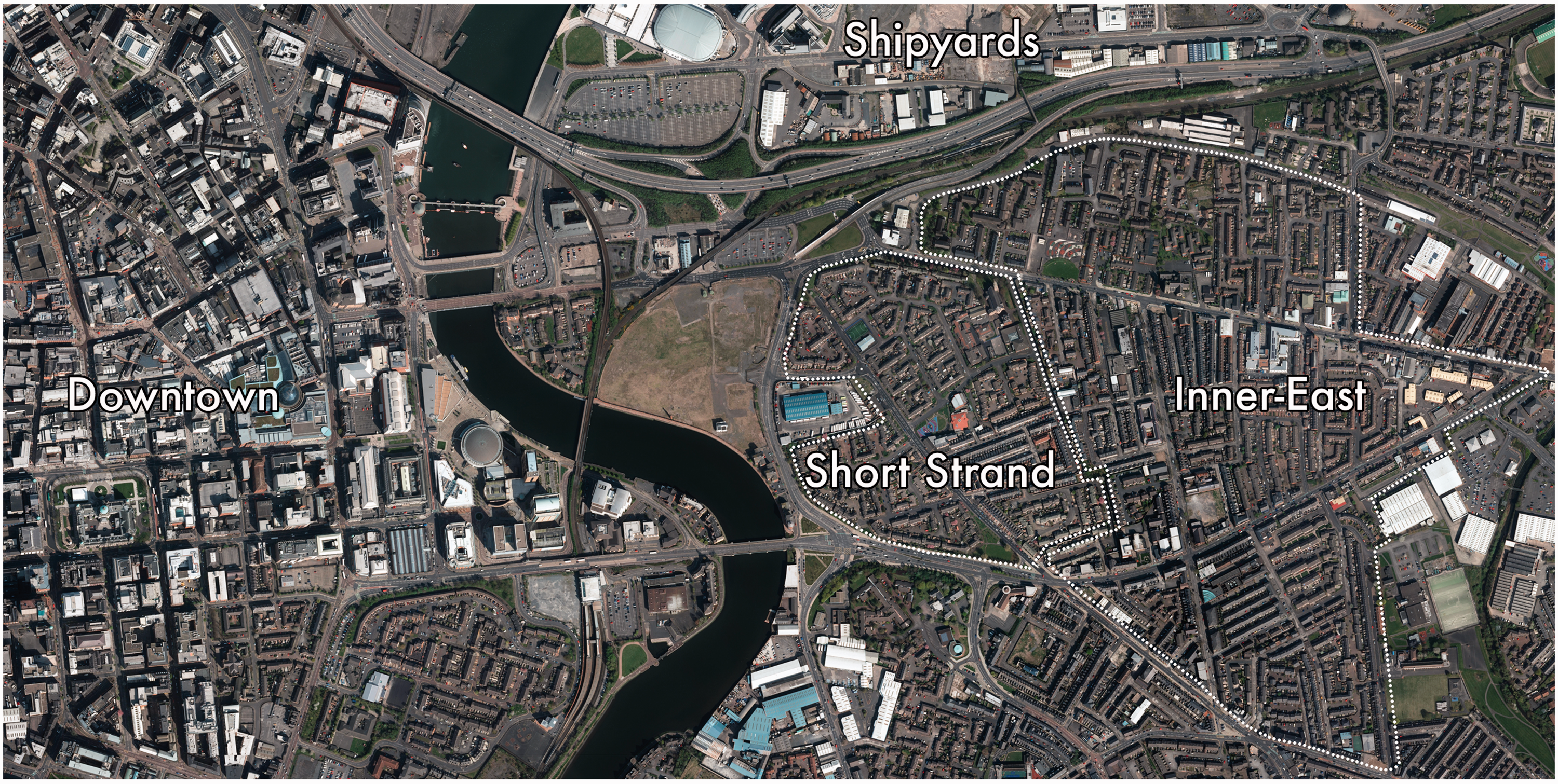
The second part of the paper focuses on the Inner-East community of Belfast as a case-study where the material consequences are particularly visible. Formerly the bulwark of the industrial-era Northern Ireland economy, this staunchly Loyalist Protestant community has been subject to the tropes of economic decline typical to many post-industrial inner-city communities (Power et al., 2011). Whilst ‘boosterist’ regeneration efforts centred on the ‘Titanic’ (built in the Inner-East shipyards) have been undertaken, they maintain a neoliberal hegemony that targets tourist revenue rather than inner-city community development (Neill, 2006). The Inner-East underwent substantial redevelopment during the Troubles and here the paper shifts toward Goffman to consider the institutionalising effects of redevelopment material practices on community interaction (Smith and Bugni, 2006). The paper theorises the Material Event as a framework to comprehend how the roads and dwellings redeveloped during the Troubles-era continue to latently perpetuate conflict-era forces in a post-conflict era. In pushing this concept further, the Material Events are animated with a non-linear dramaturgy (Hannigan, 1995) where a travelogue places the voices of designers alongside a mapping and photography of their architectural exposition. The paper concludes by highlighting the undervalued effects of these distinctly socio-material processes on interpretations of community space (Mitchell, 2003) and demonstrating the value of the research to post-conflict policymaking and importantly, the historical record. These discussions will therefore have relevance to an international discourse of contested contexts where the full implications of architectural change and its societal repercussions remain hidden from view.
The security-threat-community
As a legitimate ‘battlespace’ of conflict, (Graham, 2009) the typical inner-city dwelling and road in Belfast are suffused with particular meaning that distinguish these everyday pieces of built environment from wider and commonplace inner-city redevelopment practices. This is something more than the historical associations between many longstanding Belfast communities and their neighbourhood streets (for example, see Wiener, 1976). It is instead, something shaped by specific conflict-era material practices: a civil government social-housing programme to address security issues presented by the ‘inner-city dwelling’; and a Security Forces programme interfering with civilian use of the ‘inner-city road’ to target terrorism.
Dwellings
Belfast’s peace-walls bring prominence to the violence and segregation at cross-community residential interfaces (Byrne et al., 2012). However at the height of the Troubles in the late 1970s, this confluence of security and housing policy was just emerging. A confidential government report addressing this issue highlighted an acknowledgement of the central role played by the inner-city dwelling: The frequent use of emotive terms such as “ghetto housing” should not, I think, lead to a sweeping generalisation that all forms of segregation are per se undesirable … In a great many instances, however, segregated communities have been created by a desire to live amongst congenial neighbours, and alongside one’s own schools, churches and social recreational facilities. To characterise this trend as necessarily or in all circumstances bad in itself is to challenge the right of people to preserve that distinctive sense of community which is so strongly characteristic of life in Northern Ireland.
2
As mixed communities sort themselves out and become solidly one colour or the other, the inter-communal inter-face becomes a front line. Murders occur, people are intimidated, families move out and houses are vandalised, squatted in or at best bricked up … In such a situation, an area – often containing sound houses – may have to be held sterile for a time at least, until it is politic to let a new line of sectarian demarcation to be established.
5
The existing land use plans for the Belfast Urban Area, while envisaging the return of population to redevelopment areas at substantially lower densities than in the past, nevertheless provide for a comparatively dense and continuous residential population. A pattern of smaller residential enclaves, surrounded by substantial areas of open space, could represent a better and safer basis for the future.
6
[An] inspired debate on the subject of sectarianism is likely to provoke the riposte that all would be well if only the security situation allowed people to live peaceably outside sectarian boundaries. It would be unlikely to be actively supported by the army and the police who seem to find it easier to control violence in areas where community boundaries are clearly defined … [Better] to get on with the rebuilding of dilapidated areas [while] trying to weaken sectarian boundary lines by stealth …
7
Roads
The establishment of a clandestine residential redevelopment strategy provides a framework within which conventional processes of regeneration can proceed. Enclave approaches to place-making were very much ‘of the time’. Examples of the Dutch ‘Woonerf’ (Appleyard, 1969, 1982; Appleyard et al., 1964; Ben-Joseph, 1995; Kraay, 1986); the ‘cul-de-sac’ (Cullen, 1961; Essex County Council, 1973; Goody, 1988) and the single entry-exit courtyard (Newman, 1972, 1976) are ubiquitous throughout inner-city Belfast. These designs were no doubt applied, in part, to also address pedestrian and vehicular circulation in a highly car-dependant Belfast (Cooper et al., 2001). However, the Belfast Urban Area was the target of seventy per cent of Troubles-era bombings (Bollens, 1999). Whilst military tactics drew largely on colonial experiences (Kitson, 1972, 1977), military (and paramilitary) operations depended on control of inner-city roads where car-bound terrorists sought cover from the Security Forces: ‘In such situations where there was not immediate and close pursuit, the terrorist would simply abandon his vehicle or turn off into a side street.’ 8
The Sangars and Barriers programme of military check-points coincided with the programmes of social-housing redevelopment. Whilst there is nothing to suggest any governmental link between the two, the logic of the programme explains how the transformation of a permeable infrastructure, to one that is not, might be judged by its users irrespective of the actual intent of those responsible. Declassified correspondence reveals a hidden function of the operations to provide ‘control over road movement in the city’ in order to ‘give additional coverage in the general surveillance network.’
9
This warranted a ‘Secret’ classification and positioning of check-points at thirteen inner-city sites adjacent to military bases where they posed as extensions of base security to ‘pass unnoticed by the general public’ and be ‘controlled and supervised by soldiers in existing [bases].’
10
This covert system of intelligence gathering objectified the inner-city road as an agent in military observation, interrogation and inspection of everyday community life: … an overall advantage is to be gained in forcing the terrorist to abandon his getaway car thus probably upsetting his carefully laid plans. An abandoned car may also lead to the discovery of weapons and other terrorist equipment in the car with the possibility of fingerprint evidence being obtained for future use.
11
The environmental-threat-community
An ethnically charged legacy of policy imbalance can be found across the contested state discourse (Manning, 2004; Smith, 2003; Yiftachel, 1994, 1998; Yiftachel and Yacobi, 2003). Prior to 1971, social-housing in Northern Ireland had been the responsibility of local councils which openly promoted sectarian prejudices (Brett, 1986). In 1971 the Northern Ireland Housing Executive (NIHE) was established to: ‘to centralize housing policy and insulate it from local political biases … the NIHE’s credibility is closely linked to its use of objective allocation and new-build criteria’ (Bollens, 1999: 68). Alongside the NIHE, the Belfast Development Office (BDO) focused on areas of special need, ‘[cutting] through the red tape [to] short-circuit the statutory planning process in order to move more quickly’ (Bollens, 1999: 67). The market-orientated property-development approach (Robinson and Shaw, 1994) brought special scrutiny to the environmental-threat posed by inner-city communities amidst a dolorous Troubles-era economy: … there is over-riding need to reduce public expenditure on the housing front in the interests of the national economy … one cannot go on allowing the centre of Belfast to fester in squalor while continuing to build new houses beyond its perimeter.
15
Although housing conditions in many Protestant areas are just as bad as in Catholic areas, the possibilities of making significant progress in the immediate future are significantly greater in the Protestant areas. This is because there is now a surplus of housing (existing and proposed) for Protestants … There is considerable scope for environmental improvement in all Protestant areas, and this will be pursued … In Protestant areas a major part of the overall drive should be devoted to environmental improvement. The fact that this may not be possible initially in Catholic areas should not prevent the correct approach being adopted in Protestant areas.
18
[The] redevelopment of the Short Strand represented the most difficult housing problem in Belfast … [There] was so little room for expansion. Already 3,000 people lived there and re-development of the existing land would only provide for 2,000. Moreover, whereas in other redevelopment areas there was a shrinking population, in the Short Strand it was expanding. The only direction in which they could expand was East … The [Security Forces] re-iterated their previously stated opinion that there were serious security objections to [this].
19
Downtown Belfast, The Inner-East and Short Strand. The population of the inner part of East Belfast has been declining … The major need in East Belfast is to press ahead as quickly as possible with redevelopment and improvement on a much larger scale than is at present envisaged. There is an urgent need to achieve substantial progress in improving the twilight areas and thus stop the rot and restore confidence. There is scope for selective demolition to improve the local environment. It should be possible to sustain the existing level of owner-occupation if the decline can be arrested.
20
There are however major difficulties in devising an acceptable redevelopment scheme [for Short Strand] which leaves a viable Catholic community in a decent environment without having to resort to very high densities.
21
Places of visibility
Our sense of being a person can come from being drawn into a wider social unit; our sense of selfhood can arise through the little ways in which we resist the pull. Our status is backed by the solid buildings of the world, while our sense of personal identity often resides in the cracks. (Goffman, 1961: 320)
Despite being privileged by Troubles-era discursive operations which enabled the capacity for ‘environmental enhancement’ within the Inner-East, qualitative interviews with the designers responsible carried out as part of this research reveal a pattern of complex, ambiguous and often contradictory design aspirations behind its redevelopment. Some designers speak directly of creating safe traffic-free streets for children to play in, however, others speak quite openly about addressing vehicle-bound terrorist movement. Some designers recall a desire to empower residents with feelings of ownership over their surrounding streets. Others note the ambition to make residents feel secure in their homes. Of particular relevance is that across these alternate motives the material practice follows a consistent methodology; large masses of continuous terrace housing are broken down into much smaller clusters, vehicular through-flow is eliminated and pedestrian circulation greatly restricted. This creates a distinct circumstance with a single architectural program satisfying the conditions of different discursive operations. In this way, the architecture forms the ‘visible’ component of the Foucauldian discursive statement. It is the material representation of the given ‘sayable’ discursive policies and practices (Deleuze, 1999) where ‘ … two perfectly distinct statements, referring to quite different discursive groupings … possessing only one value, obeying only one group of laws for its construction, [involve] the same possibilities of use.’ (Foucault, 1972a: 80–81). The cumulative effect of these competing-conflicting discursive statements within the Inner-East however is a contemporary community that views this architecture simply as a deliberate response by the Security Forces to their on going potential security-threat (Coyles et al., 2013).
This triangulation between the ‘sayable’, ‘visible’ and competing-conflicting discursive forces is the Material Event. The Inner-East helps demonstrate how these socio-material episodes make it possible to glimpse both the ‘top-down’ wider systems of discursive power and its ‘bottom-up’ institutionalising effects on social interaction.
23
Ergo, in contexts where the practice of freedom is more liberal, the cul-de-sac becomes a considered piece of residential place-making. Where the practice of freedom is less liberal and constrained by the forces of conflict, it becomes an instrument of control over free movement. This synergy between architecture and community interaction calls to mind, in a conceptual sense, Goffman’s description of the ‘total institution’: … a place of residence and work where a large number of like-situated individuals, cut off from wider society for an appreciable period of time, together lead an enclosed, formally administered round of life. (1961: 11) Something always goes wrong … Resistance is part of the fact that power can only ever make a social machinery run imperfectly or incompletely … Power and resistance are together the governance machine of society … . (Hunt and Wickham, 1994: 80–83)
The Inner-East offers an analogous circumstance of where political, military, economic and ideological forces have placed undue constraints on freedoms within the social system. These have lessened the capacity for resistance and invoked a disproportionate transmittance of power. Here freedom is not constrained by fear of absolute power, but by a power-surplus created at the intersections between competing-conflicting discourses. At these intersections publically declared redevelopment policy practices permit these discourses to latently identify, target and sort the bodies of citizens through technologies which systematically erode the capacity for resistance and impart self-disciplining behaviour on the bodies of citizens (Foucault, 1980). Through discursive operations the citizen looses their individual status and becomes instead identified within a singular community entity such as the ‘Inner-East’ or ‘Short Strand’. These communities are then targeted by undisclosed power-relations which can be privileging or disciplining according to the policy biases resulting from the ethnicity of that community and the influence of paramilitarism over territoriality of the land (Mann and Haugaard, 2011). The effects of the surplus are such that, once identified, discursive technologies latently target the community through a repertoire of Material Events with consistent controls on community interaction irrespective of the specific rationale of the architect. Whether they are the bodies of civilians or terrorists, or bodies travelling on foot or travelling by car, the Material Events reveal an indiscriminate environment where all bodies are regarded as a potential terrorist threat. Here the bodies of citizens become effectively coupled to this material environment to form discursive object-hybrids (Dant, 2004; Featherstone, 2004; Sheller, 2004; Sheller and Urry, 2000, 2003). These ‘body-cars’ and ‘body-dwellings’ are ultimately organised and sorted by the architectural treatment of roads and houses. This has embedded within the community an urban fabric with a hidden capacity to impart a self-disciplining influence on how people ultimately ‘present themselves’ (Goffman, 1959).
Through the everyday rituals of community interaction the forces at play within ‘body-cars’ and ‘body-dwellings’ enjoy a perpetual process of reproduction, duplication and reinforcement. As such the Material Events permit historic conflict-era power-relations to remain present and active, but largely unseen (Garland, 1997, 2014), within the present-day, post-conflict-era. To demonstrate the complexity of the Material Events and their importance to post-conflict processes, the paper now takes a narrative turn to articulate a travelogue through the Inner-East. This journey places the words of designers alongside the architectural exposition of a series of Material Events, beginning with the Roadblocks that have been designed to eliminate vehicular through-flow before addressing a series of Courtyards which restrict pedestrian movement and interaction.
Material events
There was very little thought of looking at multidimensional plans. Your single aim was just to build houses. So in terms of thinking about the community facilities, jobs, all of those other things, it was very mono-dimensional. You were going to redevelop these areas. Communities wanted to be retained in them, politicians wanted the communities retained. So it was very much a single focus. Looking back now, there was no thought given as to how you'd actually build a community or build something that was sustainable.
24
Prologue
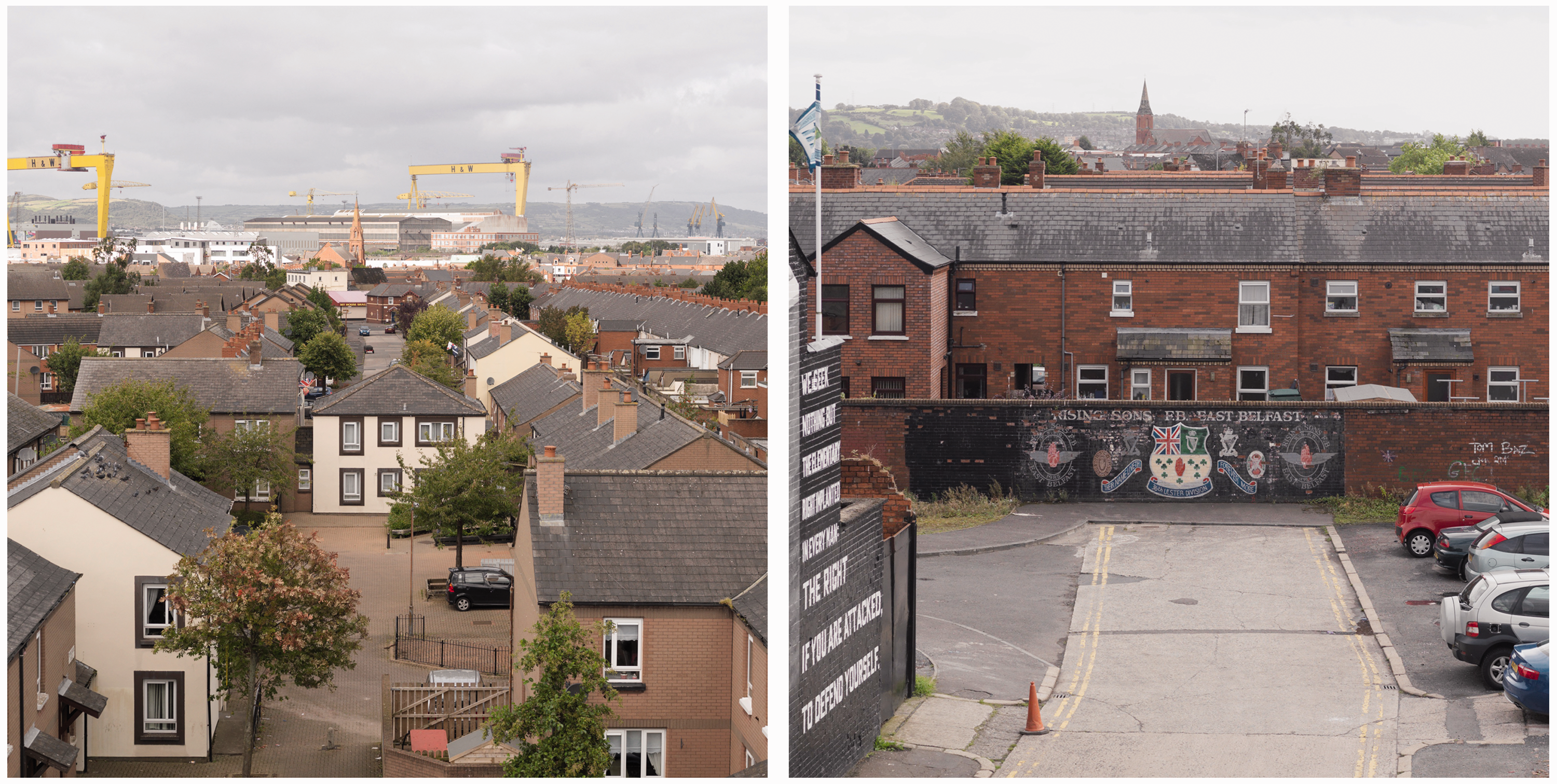
Bordered by the Newtownards Road to the south and the Beersbridge Road to the north with the Albertbridge Road bisecting it in two, the Inner-East was at the centre of Belfast’s rapid 19th-century industrialisation. Whilst now a constellation of disconnected and fragmented spaces, prior to redevelopment a lattice of Victorian terraces dominated the landscape (Figure 2). In these houses lived the second, third, fourth generations of families, families who worked in the shipyards, in the rope-works, in the linen mills. However, a reliance on heavy industry was the harbinger of a brutal process of economic decline, starting in 1930, nose-diving in the 1960s and ferociously aggravated by the violent conflict of the 1970s and beyond. A growing services sector offset some job losses but palled against a manufacturing workforce falling by 10% every decade and maintaining a higher than average UK unemployment rate which peaked at 17% in the 1980s.
25
A youth unemployment rate of 27% now far exceeds the UK average. Low self-employment, high levels of disability payment dependency and a population of 60% with low-level or no qualifications make the Inner-East one of the most deprived wards in Northern Ireland, ranked in the bottom ten percentile across government deprivation indices.
26
The Inner-East street network prior to redevelopment (left) and after redevelopment (right).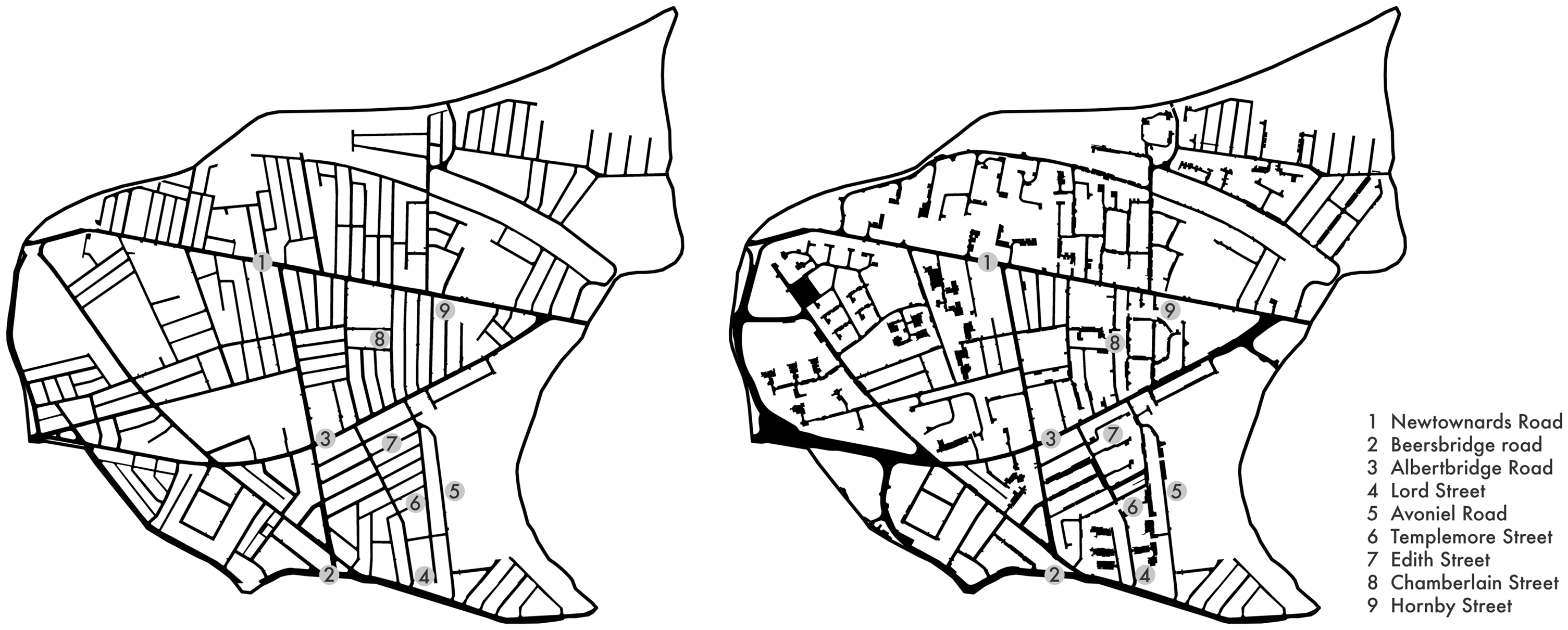
The 97% Caucasian population of today remains divided along psychological, physical and ethnic lines. Yet the locals of the Inner-East still reminisce about the vitality that once pulsed through a community that was both the economic heart of the city and the epicentre of Belfast’s Protestant culture. They talk about the sense of ‘community’ that this brought, of having pride in their houses, of talking to each other ‘on the doorstep’, and of scrubbing this doorstep clean (for this is an act of pride) and of children playing in the streets in front of their houses, playing football, tag, ‘British Bulldogs’ and the like. And what’s more, whole families, entire families, cousins, brothers, sisters, uncles, aunts, were only ever but a few doors, or a few streets away. People felt a sense of ownership here. They felt like they belonged. They knew that these streets were their streets.
Roadblocks
And the short answer is no, it wasn't the security issues, it was Road Service didn't like ‘rat-runs’ … people getting a short cut.
27
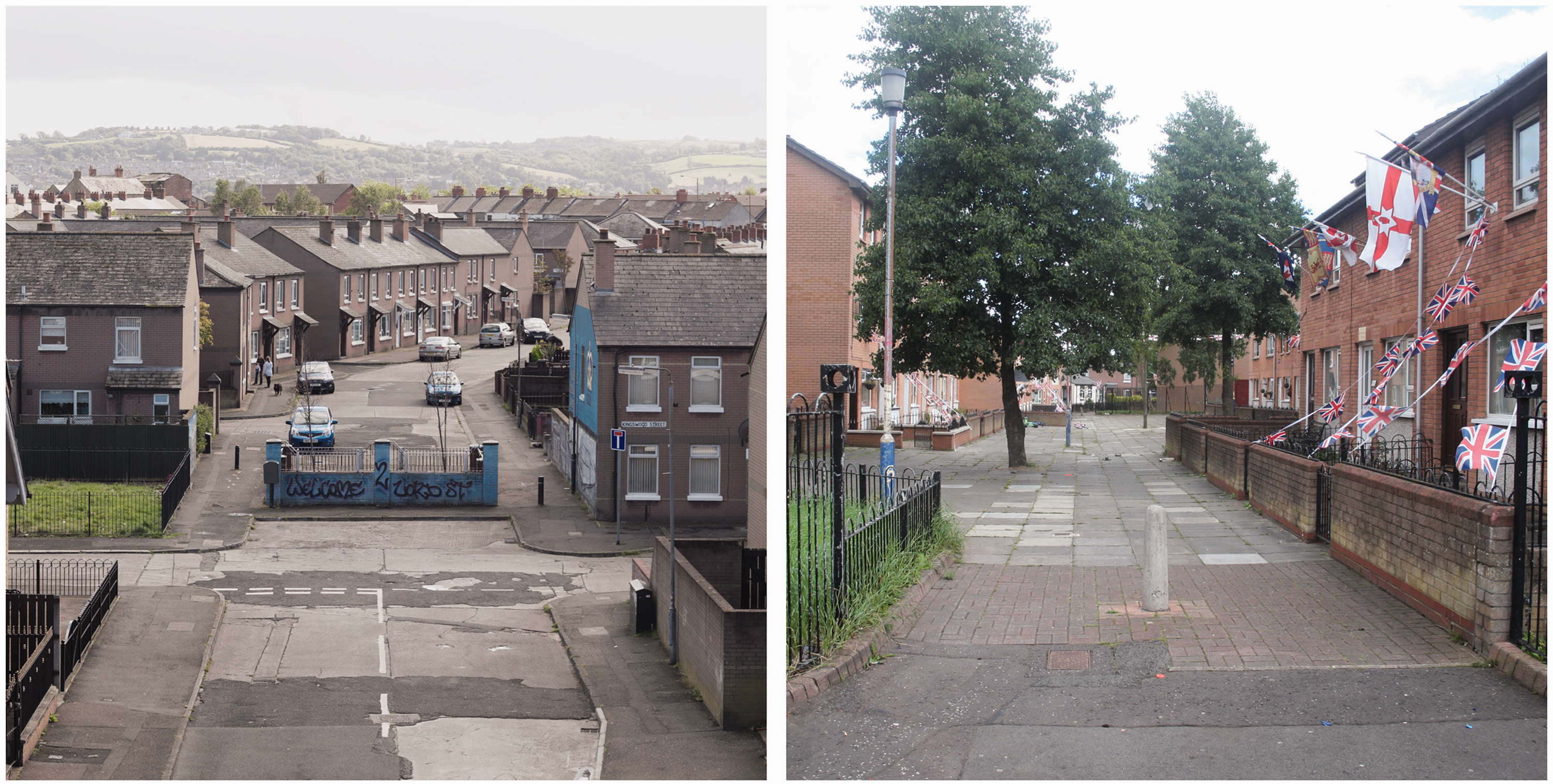
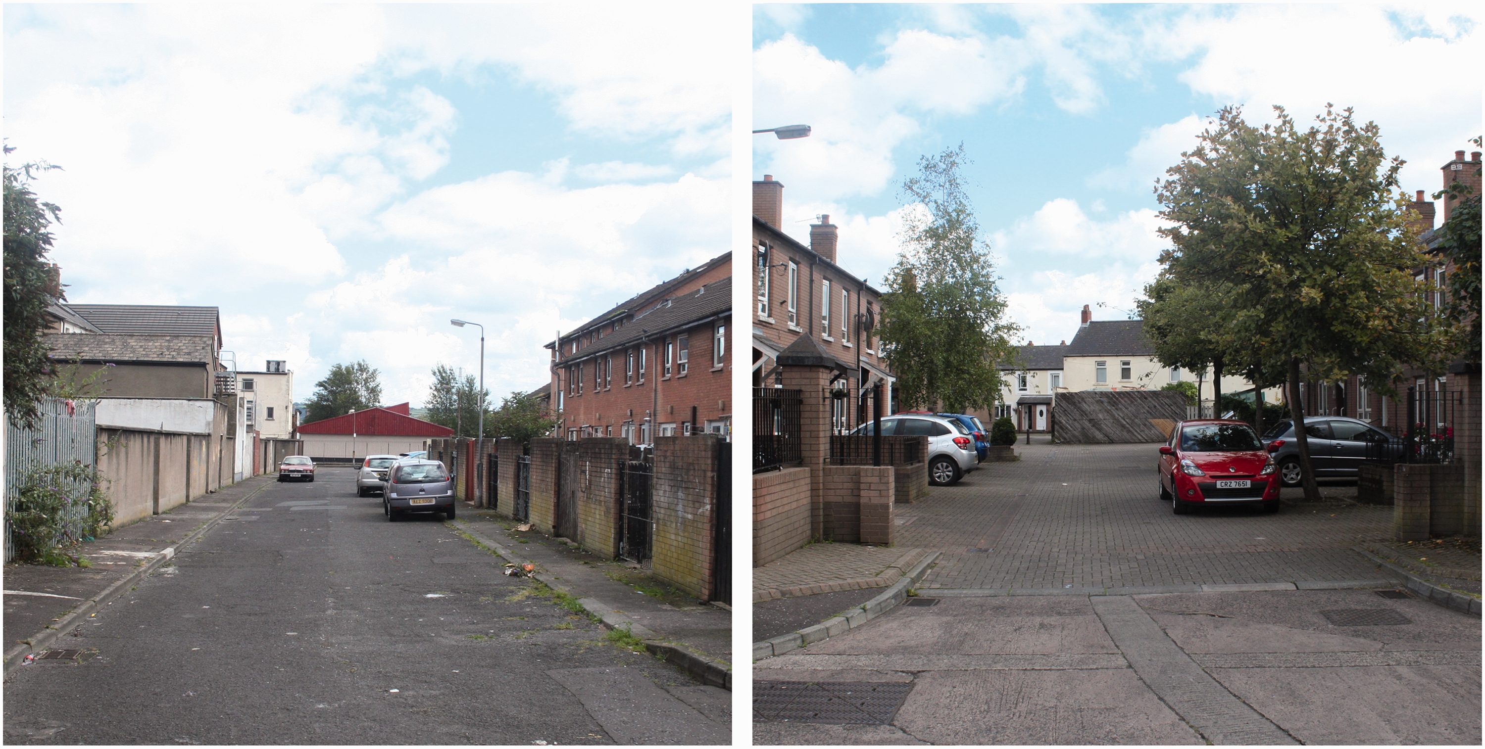
Driving across the Inner-East was once possible through a parade of main-streets, side-streets and alleyways. But now it is simply impossible to cross this terrain by car. Whether because of traffic-calming or security-resilience, this prohibition on the car is absolute. There is no choice but to circumvent the residential streets by travelling along the exterior arterial routes. This leaves but two points of vehicular access for those wishing to pay a visit to the houses of the Inner-East; Hornby Street off the Albertbridge Road, and Lord Street off the Beersbridge Road. At every other turn architectural forms sit on the roadways like pieces on a chessboard placed strategically to halt onward movement: [We] tried to break the areas down and make them much more private for those that lived there. We built in quite crude ways, building walls maybe here and here to stop through-traffic and through-movement and give the folks that lived here more ownership. That certainly was the theme.
28
Roadblocks at Hornby Street (left) and Chamberlain Street (right). Roadblocks at Avoniel Road (left) and Chamberlain Street (right). [The] Northern Ireland Office did have a hand in the security aspects of the redevelopment through Roads Service. You would have been shown plans and they would have been looked at in that respect [and the opinion] would have come back through the Road Service [stating] 'we'd prefer if you didn't do this.
29
There was an expressed desire to reduce the number of through-routes … so that there was safety for kids to go out on the streets … they wanted us to create residential areas that were quiet. It wasn't totally their views but it has had the unfortunate effect of leaving all the street-ends blocked off.
30
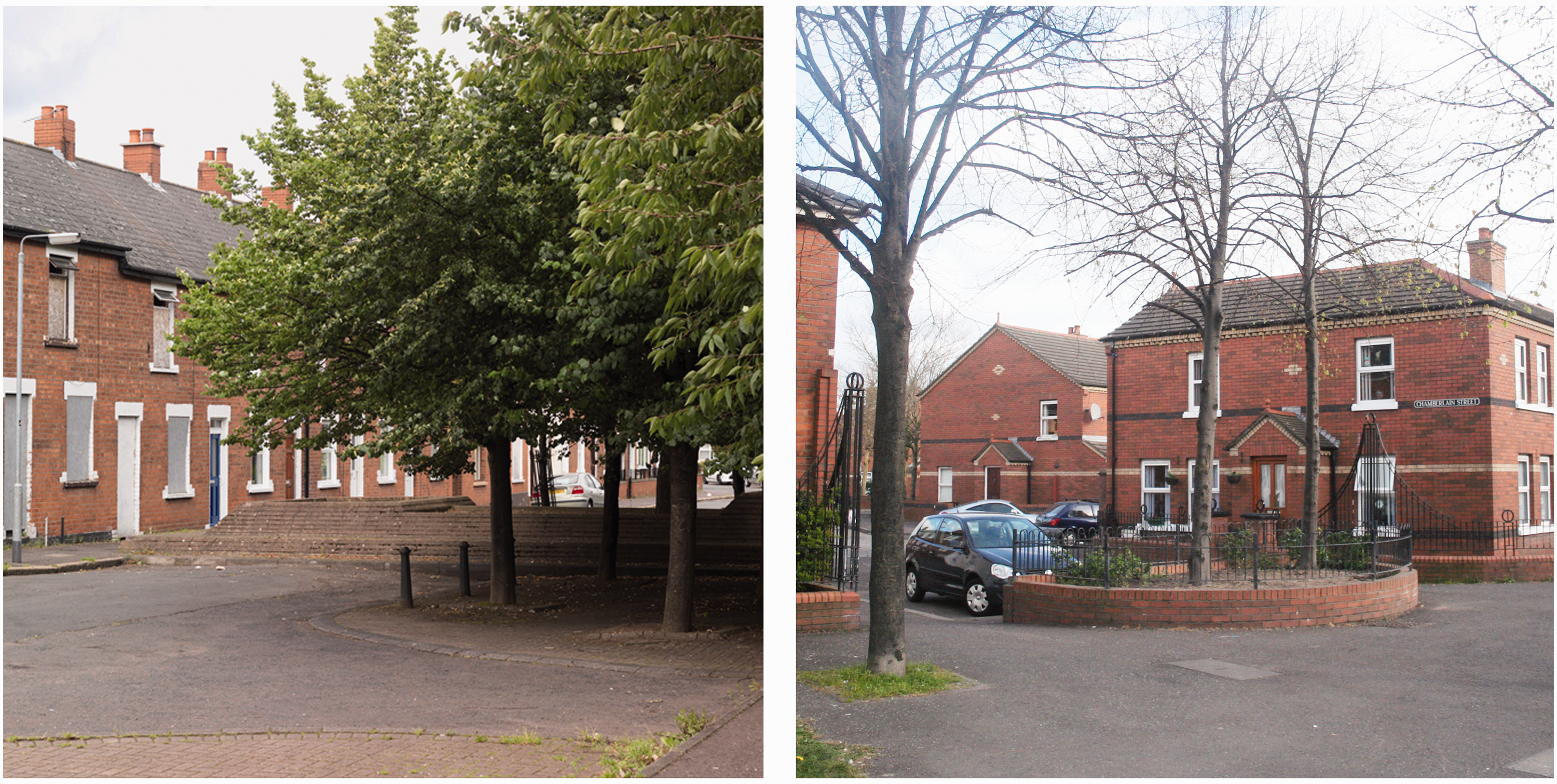
Templemore Street divided in two by a house (left); A leftover piece of roadway (right).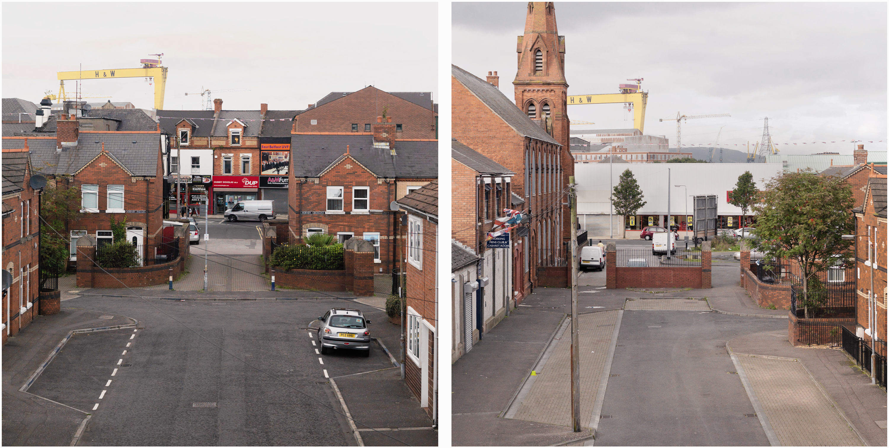
Travelling back via Lord Street you can drive along the determined lines of this old Victorian street and be confident that it must be leading somewhere. But the car must stop and finally be abandoned at the most bizarre Roadblock of them all, a small square paved area defined by a pillared wall to its back and a half-wall with railing to the remaining sides. Black bin-bags of rubbish are dotted around it. The paved surface is uneven, broken and lined with weeds. Whilst wider attention tends to focus on the divisive power of architecture between different communities in Belfast, this Roadblock is a formidable example situated within an individual community. It is a materialisation of the distinct flows of government power and paramilitary resistance that operated during the Troubles-era: I remember there was one club here, I remember going in to meet the owners about the redevelopment here. You were taken into the club and then through locked doors to the sort of inner sanctum of these guys, it was scary stuff. I mean that's where I really felt I was in the back room of some club with some guys that were in control of their area.
32
[Residents are] told by the gatekeepers, we need a certain area to look bad … be downtrodden and then we will get more grants for the community, we'll get more money and we can put more back into your community.
37
Courtyards
There would have been no security implication here. It comes back to what it began with, trying to create areas that didn't have ‘rat-runs’ … it seems logical, I suppose, to create a cul-de-sac type of living … if you had through-runs you had a lot less scope in the design because you would have had a lot of traffic coming through and it would constrained what you could do. It was to try and keep these areas more as residential areas so you only went in there really if you lived there. I shouldn't think that's a bad thing.
38
Walking through these streets exposes a clear progression in experimentation with the place-making trends of the time. The first Courtyards at Edith Street reveal ‘a clear divide between pedestrians and cars, trying to make areas much more secure and controlled for the residents … to try and give people privacy and security’.
39
The result is a dichotomy expressed in pedestrian and vehicular space. The pedestrianised Courtyards entreat privacy through ‘defensive planning’ tactics utilising the natural surveillance provided by living-room windows and the emphasis of personalised thresholds, provision of small gardens and sub-division of communal space. There is a clear attempt to establish a sense that individual people live here and that they may be watching you. Although, such flourishes can become quickly intimidating when they are garnished with a symbolism which reinforces the territoriality of a single-identity community (Figure 6). To the rear of these dwellings the vehicular segregation has provoked something else altogether. Here, refuse, weeds and signs of vandalism are visible everywhere: The thinking of the architects at that time, it wasn't shared-space at that time, it was to separate vehicular and pedestrian access … simply it was a number of terraces were built, they would front onto a pedestrian area and then all of the vehicular access came in at the back … And the thinking at that stage before the shared-surface idea was to split those apart but you ended up with dead spaces at the back … anybody could come in and wonder in, that was where you got the antisocial behaviour.
40
Roadblock at Lord Street (left); Pedestrianised court at Edith Street branded by Loyalist flags and bunting. So we began to move back to the idea of a street where folks at least had some private space … it reflected the debate going on at the time, moving from somewhere where folks had no private space of their own … They'd moved away from the old idea of streets, which is what folks often wanted. [The] design thinking around these redevelopment areas was how do you move back to something that gives local people control, and I suppose keeps those that aren't from the area out.
43
Vehicular priority zone (left) and ‘shared-surface’ courtyard (right). … you will find there are back entries [and] you would find there are gates on them and it was simply because people were using them for purposes that they shouldn't have used them for. [It] was means of [terrorist] escape [and] this was found out to be occurring. If you had an area where you can go ‘that way, that way and that way’ there were a lot of terrorist incidents. I think that was partly why [the government] tried to tighten up on that. They didn't only use the terrorist thing. There was also the fact that the streets were a short cut for people to get from one road to the other in busy traffic times. You didn't want that either.
44
… you've to be careful when you're … a police vehicle going into a cul-de-sac … they could block it off with a car or something and you're stuck in there. [During rioting] the water cannon couldn't get close enough and the community use that, because of the cul-de-sac, we couldn't take the water cannon into the street. [We] couldn't engage them, couldn't get up close to them …
47
Epilogue
When you emerge onto the Newtownards Road and walk back towards the centre of the city you will, quite remarkably, pass a few small streets which escaped redevelopment entirely. Movie and television crews come here now in search of a place to imagine the old Victorian city. Look closely and you will see telegraph poles, electricity cables and satellite dishes dotted amongst the cobblestones and cast-iron gas lanterns of a bygone era. These will, of course, be edited out in post-production. But this remains a small gesture when weighed against the more dominant evocations of cultural history found in the panoply of flags that adorn some nearby streets (Glasgow Rangers Football Club, flags of the Orange Order, the Union Flag, and occasionally an Israeli flag)
48
and the looming sectarian murals which reappeared in 2011.
49
Images of guns and men in balaclavas ominously proclaim: We seek nothing but the elementary right implanted in every man: the right if you are attacked to defend yourself alongside a vacant public house branded Property of East Belfast Ulster Volunteer Force, Not For Sale (Figure 8). These vestiges of local paramilitary might sit astride from rows and rows of empty shops now papered with pictures of a past existence.
50
Someone looking to traverse the Inner-East would not pass through here. They would not want to take a chance. They would walk on.
Loyalist paramilitary branding of local Inner-East buildings.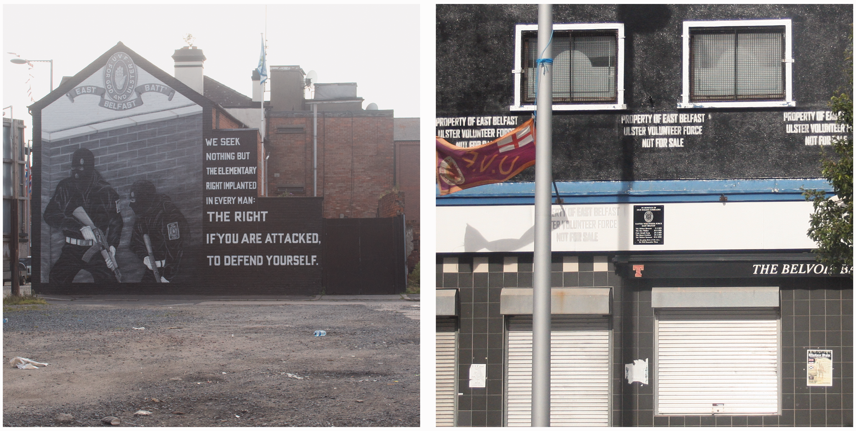
Conclusion
The Material Events emerge as a powerful example of the mutually conditioning nature of architecture and people (Kendall and Wickham, 2000) where the dynamic subjectivity of ‘meaning’ between people and their environment can be made visible (Goffman, 1951, 1959, 1961, 1963). The latent forces which power such feelings are embedded in a material realm which is itself a complex archive of pre-existing conflicts (Weizman, 2010). The political, military, economic and ideological power-relations which constitute this archive, whilst powered by the forces of conflict, have ultimately shaped a contemporary inner-city that is struggling with social, economic and environmental deprivation challenges common across a realm of post-industrial cities. As such, the part that the everyday roads and houses of the inner-city play in aggravating this condition remain overshadowed by more conventional narratives which myopically frame Belfast as a conflict city. The research therefore suggests a number of important ways in which the Hidden City extends current critical consideration of post-conflict Belfast.
High-profile judicial inquiries (Campbell, 2013); alleged state-terrorist collusion (Lundy, 2009; McGovern, 2013); failed cross-cultural economic initiatives (Flynn, 2011; Neill, 2006); and a contentious establishment of cultural equality (Aiken, 2010; Coyles, 2013; Graham and Nash, 2006; Hamber, 2002) highlight the profound volatility of post-Troubles society. As such, there is a need for post-conflict policy to actively engage with the sensitive disclosures at the heart of this paper. The recognition of inequality in Troubles-era redevelopment policies would require a careful handling and challenge conventional community-relations strategy in Northern Ireland. To do so would, quite appropriately, place the everyday architecture of the inner-city at the core of post-conflict policy-making. 51 Such thinking also demonstrates a need to urgently reappraise the dominance of a ‘two communities’ narrative in post-conflict architectural discussions. As post-conflict architectural policy maintains a singular focus on the inter-community issue of removing ‘all peace-walls and interfaces by 2023’ (OFMdFM, 2013) the Inner-East makes visible a much larger and more systemically intricate system of divisive intra-community architecture prevalent across the city. This is a distinct typology of conflict-architecture that remains unacknowledged in post-conflict policy.
Then there are the more fundamental questions of living with an urban environment that was (in part) engineered in response to a violent conflict now largely in the past. The tensions evident in the use of material practices within the public realm to mitigate against security-treat provides a prescient illustration of a growing contemporary dialecticism between the maintenance of societal freedoms and the embedding of resilience against potential terrorist attack within the urban fabric (Coaffee, 2009a, 2009b; Coaffee and Murakami Wood, 2006). In Belfast, the material resilience provided by the Hidden City does not take the form of impermanent gates, barriers and screens. By enshrining the response to a short-term security threat into the very bricks and mortar of the inner-city, the communities of Belfast are left to deal with the myriad pragmatic urban design challenges that such a controlled infrastructure presents. Traffic management, civic amenity, urban mobility and crime-control all remain affected in inconsistent ways by Troubles-era redevelopment practices. The persistent community interpretation of the consequent effects as an overarching system of control renders the competing-conflicting intentions of the designers incidental (but not irrelevant) to the insecurity and vulnerability of conflict itself (Piquard and Swenarton, 2011). As such, there are also distinctly humanitarian implications for the communities that continue to be subjected to a Hidden City of architecture which has institutionalised conflict-era forces and their limitations on freedom. An inclusive and comprehensive post-conflict architectural policy must acknowledge the need to re-evaluate the undervalued role that the architectural specifics of inner-city housing play in perpetuating adverse and problematic post-conflict conditions.
Footnotes
Declaration of conflicting interests
The author(s) declared no potential conflicts of interest with respect to the research, authorship, and/or publication of this article.
Funding
The author(s) disclosed receipt of the following financial support for the research, authorship, and/or publication of this article: The author would like to thank the United Kingdom Arts and Humanities Research Council for their funding in support of this research.
Notes
![]() ).
).