
Abstract
This article explores place-based geological storytelling by examining the role of training sites in the geoscientific learning process. Based on ethnographic work conducted with geoscientists in the Liquiñe-Ofqui Geological Fault, I illustrate how sites located in the Chilean Andes have historically been used to practice geoscientific storytelling and to learn the language and theory of plate tectonics. Building on scholarship in STS and the history of science which has documented how plate tectonics and the associated paradigm shift changed the authority of field geology, I show how, rather than replacing fieldwork, place-based observations still play a central role in helping students gain a professional vision in geology. Reflecting on fieldwork training sites and geoscientists’ negotiated attempts to tell geological stories, this article speaks to the question: from where are the stories of the earth told?
Introduction
A granite outcrop can be a geological archive (Figure 1), according to the geoscientists with whom I conducted fieldwork in El Valle de Liquiñe, in Southern Chile. The group uses these rocks to study the Liquiñe-Ofqui Geological Fault, the largest active geological fault in South America. These rocks express the friction occurring between the Nazca and South American tectonic plates. The resulting outcrop of the fault system provides the material evidence that allows the group to tell a geological story (Figure 2). This particular site is defined as an archive by the geologists with whom I conducted fieldwork, because the textures of these faulted granites tell the story of a rock exhumation process beginning less than 6 million years ago (Ma) and occurring 10 km below the surface. To study geological faults, one of the fundamental concepts in geological fieldwork is that rocks visible at the surface tell a story. Juan, 1 a doctoral student, made explicit the historical nature standing in front of this rock (Figure 1) as showing evidence of fault movements, explaining: “fíjate, ¿Lo ves o no? Hay una historia acá” (“Take a look, do you see it or not? There's a story here”).
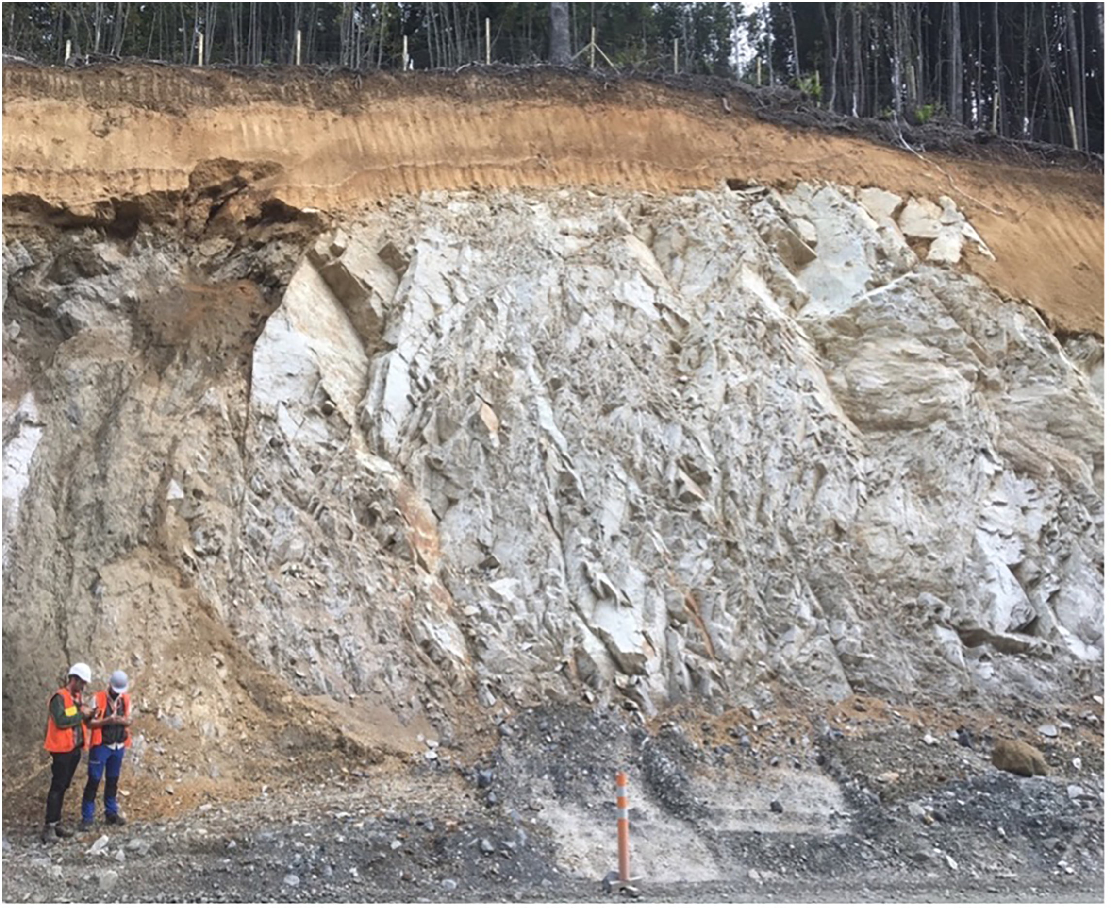
Granite outcrop studied by geoscientists at Cuesta Los Añiques in El Valle de Liquiñe, in Southern Chile. Photograph taken by the author, 2019.
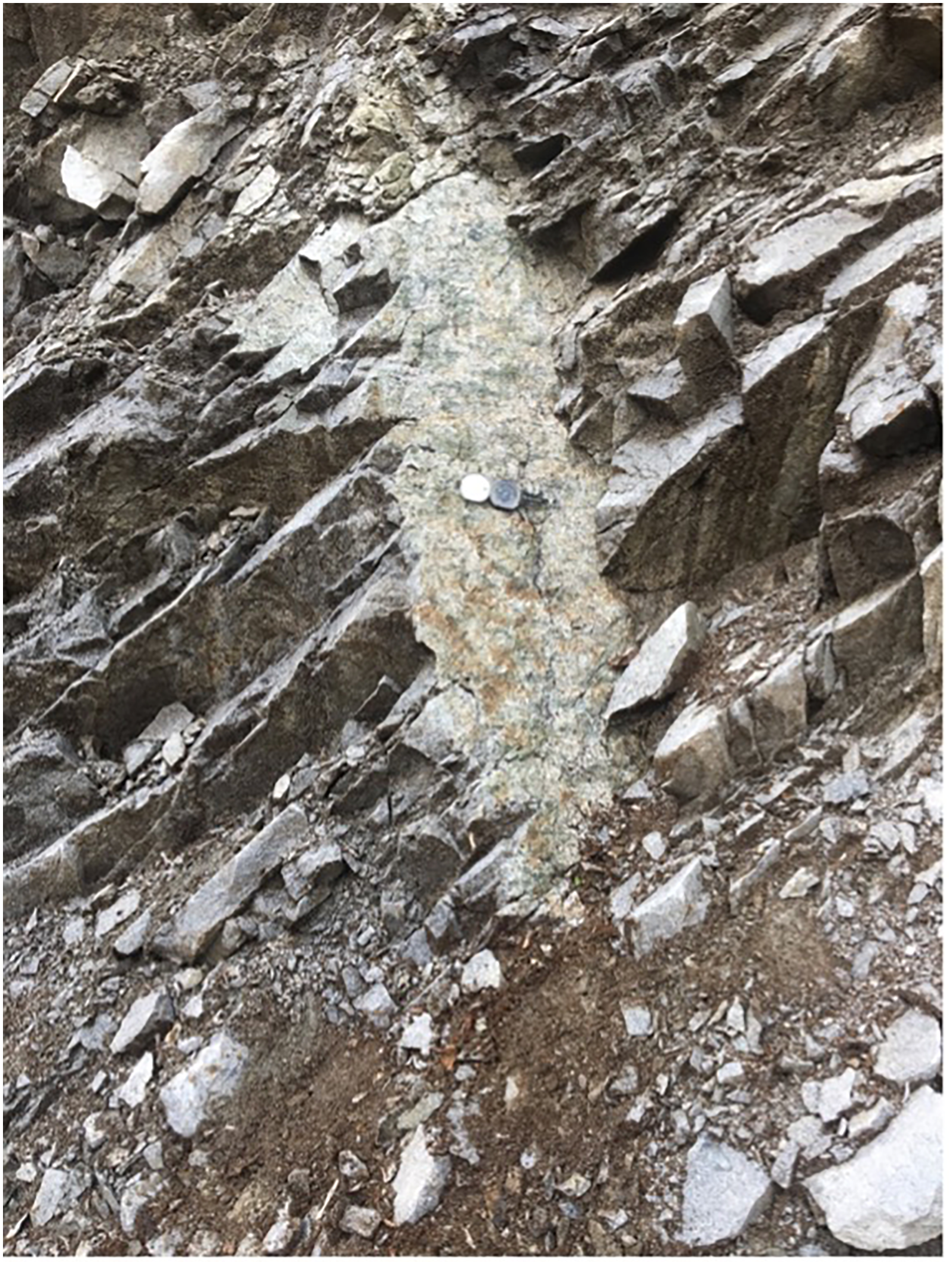
A fractured rock studied because of its texture. A compass placed in the middle of the rock serves to provide a sense of scale, to record its spatial dimensions. Photograph taken by the author, 2019.
However, this site is also an archive of the history of geology in Chile and an iconic place for training students in a geological vision. The outcrops at the Liquiñe-Ofqui Geological Fault have become an iconic place for training in geoscientific storytelling and the language of plate tectonics. These geological sites have commonly been used to educate students in geological orientation through field observations: studying fault deformations requires understanding the orientation of fractures seen in the rocks. Geologists can reconstruct past tectonic activity by analyzing rocks at the surface. However, whether a rock texture becomes evidence of a geological story depends on where it is found in terms of geological scales. It is precisely this storytelling ability that is taught to geologists through fieldwork. Tools such as compasses, hammers, magnifying glasses, and representational artifacts such as maps and drawings, do not merely aid the preservation and generation of observations: they also mediate geologists’ “professional vision” (Almklov and Hepsø 2011; Goodwin 1994). Tools and visual representations shape professional discourse regarding what is worth seeing and examining, and what is not.
Doing fieldwork at these sites, I realized that discussions with and corrections from supervisors regarding students’ decisions taken in the field (for instance, the selection of a particular site or fractured rock for observations) were fruitful opportunities to observe how professional vision is trained (Goodwin 1994). Fieldwork experiences are intimately tied to the very identity of geology as a profession (Kastens et al. 2009): in order to cultivate a professional vision, field experiences are essential for learning how to read rocks.
As Lisa Messeri (2016) notes, scholars in Science and Technology Studies (STS) have mostly focused on places as sites where scientific practice occurs (e.g., the laboratory and the field). Although places and settings where field practices take place mediate geological observation, I investigate how field observations are contested or become a matter of concern in the learning process. I explore these questions based on fieldwork with geoscientists measuring a geological fault. Analyzing geological observations, I focus on spaces for scientific training in “reading” geological archives. This paper is based on material gathered during ethnographic fieldwork in El Valle de Liquiñe. I joined three geoscientific expeditions from the Andes Geothermal Center of Excellence (CEGA) at the University of Chile and Pontifical Catholic University of Chile. El Valle de Liquiñe is an iconic site for geothermal studies due to the presence of thermal springs and fractured rocks associated with the Liquiñe-Ofqui Fault (Fonck 2023). At this location between December 2018 and May 2019, I accompanied and described the process of producing geological evidence by measuring rocks and taking water samples. This work was a continuation of ethnographic research in the Southern Central Andes I had conducted between 2012 and 2017. This article focuses on rock measurements along geological faults, and how geoscientists read earth stories in their surface manifestations.
These sites are associated with the consolidation of a professional vision and a particular approach to storytelling based on field observation mediated by the language of plate tectonics. This article begins by situating these pedagogical sites in the history of geology in Chile. With this aim in mind, the next section describes the role of these sites in the Liquiñe Valley in the consolidation of Chilean national geoscience, and the institutionalization of plate tectonics theory as the primary language.
Chilean National State, Geology, and Plate Tectonics
It was not until the formation of the Chilean national state in the nineteenth century that scientific expedition—and the capacity to explore subterranean potential—played a significant role in building the national public sphere. During this period, national narratives went hand in hand with the description and measurement of potential natural resources. In Chile, visual representations of the Andes have played an active role in national discourse and the production of the country's territorial identity. As the historian María José Correa-Gómez (2017) describes: at the end of the nineteenth century, the images of the Andes portrayed by the new republican, enlightened sciences established them as a space of interest for naturalist travelers, offering the possibility of accessing unique and extraordinary knowledge through field expeditions. A process enrolled, on the other hand, in the state's interest in mapping mining resources for future extraction. From a broader perspective in Latin America and Chile, mountains were framed as potential spaces awaiting animation through the deployment of appropriate extractive practices, knowledge, and devices (Ureta and Flores 2018).
An iconic case involved the Polish mineralogist Ignacio Domeyko, who was hired by the Chilean state on multiple occasions between 1841 and 1889 to lead expeditions to provide a geological and mineralogical description of the Andean formation for mining purposes (Mendez, Prieto and Godoy 2020). During this period, Domeyko also became one of the first chancellors of the Universidad de Chile, imbuing scientific education and institutions with the belief “that the study of Chile's natural environment was a way for the new country to find its own ‘reality,’ instead of copying European models” (Schell 2019, 5). The production of geological knowledge to explore subterranean territories has been at the core of Chile's political and historical processes of mapping mining resources for extraction.
Geology played an important role due to its empirical reading of the Earth's structures in situ. The promotion of these scientific practices collaborated in transforming subterranean territories into “legible nature” and opening epistemological spaces for economic and political measurements (Braun 2000; Melo Zurita, Munro, and Houston 2018). Maps and new techniques helped to explore, know, and manage subterranean domains, thereby expanding the state's interest from horizontal spatial boundaries toward a new vertical territory (Braun 2000).
In this regard, geology and national imaginaries were interwoven with the possibilities of extraction offered by underground spaces. The relationship between geology and mining in Chile has been a topic of interest in social science and humanities (Mendez, Prieto, and Godoy 2020). This interest is also present in STS and anthropology, addressing how models of Andean’ plate tectonics enabled new mining promise in Ecuador based on the potential for mineral extraction and comparison with Chilean geology (Kneas 2018). The recent promotion of Ecuador's resource potential contrasts with the history of geological observations, declaring it as a country of mineral scarcity. Kneas (2018) discusses the role of plate tectonics in the promise of resource potential from the Andean uniformity, reinforced by the subsurface copper models that emerged in the 1970s.
However, in contrast with Northern Chile where mining projects are mostly concentrated, the site studies discussed in this paper, located in the Southern Central Andes, are not directly related to mining extraction. The particular way in which these places become a matter of interest for geosciences is based on the function of educating and training new generations of geoscientists in the language of plate tectonics. In the second half of the twentieth century, these geoscientific sites at Liquiñe Valley 2 in the Southern Central Andes started to play an important role for the study of plate tectonics. The interest in these sites is related to the institutionalization of Earth system science as a scientific field in Chile, interested mainly in studying plate tectonics, and generating key knowledge for national agendas concerned with the risks of events such as earthquakes and volcanic eruptions.
In addition, these national processes were part of the consolidation of the global project of Earth system science. A critical factor in the consolidation of the Earth science described by Doel (1997) was the scientific fervor that accompanied the plate tectonics revolution in the late 1960s. One factor mentioned by Doel is its success as a unified physical theory providing explanations for traditional geological questions such as the formation of mountains or fossil continuities. The acceptance of this theory also had an effect in shifting authority away from traditional field geology toward physics and chemistry; a shift that also had an effect within academic institutions and on ways of teaching and training new students in physics-based approaches. 3
Liquiñe-Ofqui Fault in Chilean Geology
While conducting field measurements in the Liquiñe Valley geological sites with the group of geoscientists, I learned of the sites’ iconic status for geosciences and the study of plate tectonics in Chile. As Juan said: “Here is where the Liquiñe-Ofqui Fault was first described by Francisco Hervé,” showing me the specific site where many students had conducted studies following the observations made by the renowned geologist in the 1970s. In Chile's capital, Santiago, I interviewed Francisco Hervé, to trace the history of geological observation in this area. As he describes: Around the year 1970, we went. We had a student doing his thesis…on the geology of Lake Panguipulli. I remember that we made an excursion up to Liquiñe. And there we saw a rock, which were those typical rocks of fault zones. So, I told them that we had to study this issue, and we put a student to do his thesis in that area. (Interview, Santiago, January 8, 2019)
These study sites are archives of the consolidation of Earth science as a research field and the training of field observation by geologists working at the University of Chile. The studies conducted in Liquiñe Valley since the 1970s played a role in the adoption of the language of plate tectonics theory in Chile. However, the uses of plate tectonics to explain this geologic system, and its acceptance in the teaching of geology, implied a reconfiguration of professional visions in geology. Hervé described how this language began to be used in Chile: Plate tectonics began at the end of the 1960s. The first time it was heard about them in Chile was in 1970. I did not hear about it in my doctorate in France. In 1970 there was a conference in Buenos Aires on the upper mantle, and that was the first time we heard people talking about plate tectonics here in South America. They were some very young North American guys who were doing their PhDs in marine geophysics and things like that, and they had a very strong confrontation with the older, more traditionalist, who were the Russians. Even one of the keynotes at that conference, which was given by a Russian, listed ten reasons why the plate tectonics theory was false. It was the keynote at the conference. It was a lot of work to introduce that vision of geology in Chile. (Francisco Hervé, Interview, Santiago, May 24, 2019) Nowadays, everything is done with Google and GPS and marked on this material. On the other hand, we used to do it every night, we would place ourselves observing the maps to draw them and then put the places we visited…That can still give you a better understanding of the place…In the end, it's better; It's better because it's easier to observe. (Interview, Santiago, May 24, 2019)
Training Geological Storytelling at the Liquiñe-Ofqui Fault
The suggestion at the beginning of my fieldwork that the rocks in the Liquiñe-Ofqui Fault tell a story acquired a new meaning when I realized they are used to train students. In addition to being a geological archive to trace earth's stories, the rocks are an archive to train geologists into how the stories should be told. Accompanying this group of geoscientists, I turned my attention to the learning processes behind training a way of observing rocks, and the uses of these locations to understand and observe a place from a geological perspective. At the same time, my learning process, like that of the geology students, was gaining insight into the pedagogical nature of these sites.
My role in this group of ten geologists was assisting with field tasks, specifically taking rock measurements and samples, which required learning to distinguish rock textures and understanding how the evidence for a geological fault is produced. In this process, learning to do field tasks became an opportunity to conduct my own field research while also contributing to the group. This was feasible thanks to group members’ willingness to teach basic concepts to an outside observer from a different academic discipline. In fact, a key dynamic was that the doctoral students leading the field campaign were keen and passionate about teaching how to observe and interpret geological features. How to do this while maintaining a geological orientation was also being negotiated in this location.
The study of plate tectonics mainly involves reading rock textures, a crucial concept for geology. In petrology, a branch of geology concerned with the characteristics of rocks, texture is defined as the physical appearance and characteristics of a mineral composition. The associated nomenclature allows geologists to describe and communicate their observations of rocks, including visual appearance, enabling rocks to be identified and classified within a system of textures and time scales.
While measuring rock textures and fractures, it is easy to get disoriented. Juan, a doctoral student interested in combining field information and “big data” modeling, identified a new site and suggested using the FieldMove Clino app to obtain rock measurements. This was the first time I heard about this technology, which caught my attention as it was not used in previous explorations I had joined. Although the group used smartphones to take images in the field, I had not anticipated the possibility of also using phones to obtain data. Due to my interest, Juan showed me a YouTube video explaining how the app works.
In the video the developer of the free app illustrated its functionality and potential in geological fieldwork, stating: “I think every geologist loves fieldwork. They often say that the best geologist is the one who's seen the most rocks. It is where we learn to appreciate the scale and geometry of structures and understand how things work in three dimensions” (Midland Valley 2015, 00:07). The app developer reinforced the notion that fieldwork is at the center of geological learning processes, highlighting the visual training the profession requires. The app promises to provide solutions to fieldwork challenges, and further, to use smartphone sensors to collect data much quicker than traditional methods. The video describes: Field mapping can be quite a laborious task. You have to carry a lot of equipment with you—a heavy map board with a waterproof cover to protect your paper map. You have to carry a hand bearing compass, you have to carry a very good camera with you, and a notebook. All of that can be replaced just simply with the technology that now exists on your smartphone. So we have developed an app for the smartphone called FieldMove Clino, and it uses the sensors in your phone and turns it into a digital compass clinometer. It also has a notebook inside and a camera, and it lets you basically collect data almost ten times faster than you would with a traditional hand bearing compass. (Midland Valley 2015, 00:26)
In addition, the app offers the possibility of collecting more data and combining multiple functions within one device, functioning as a notebook, compass, camera, information recorder, etc. It even promises to take measurements, up to “ten times faster.” As Juan joked while showing me the YouTube video for the app: “This is part of the society we are living in, where everything needs to be instantaneous.”
Days after we started taking measurements of fractured rocks with the app, we returned to the newly discovered site with a larger group of geologists, including the professor supervising the doctoral research. Juan, who had decided to take measurements in this area, struggled to defend his choice of these particular types of rock. The supervisor indicated that the textures and ages of the chosen rocks were not related to the geological history the group was researching.
As his colleague Sebastián explained to me afterward, Juan had lost his “geological orientation,” the sense of one's own position within geological temporal scales. Geologists observe the texture of rocks as a guide to temporal and spatial orientation. “You have to look where you are!” Sebastián explained; “Juan has focused too much on taking data without observing, without gaining a general appreciation. The worst thing that could have happened to him was when he started taking data with that app.”
For Sebastián, the datafication of fieldwork represented a problem, “Juan has to learn to observe. He is obsessed with taking data.” More importantly, Juan was unable to tell a story, according to his colleague Sebastián. In geology, this is done by scaling the phenomena and understanding “geological ages expressed in given areas. Situating them in relations, knowing where you are standing in temporal scales,” Sebastián added. As a result, Juan's innovation of using the app was dampened, together with the promise to conduct fieldwork faster and more efficiently, and overcoming some of the difficulties of fieldwork.
By joining this group taking measurements, I became disoriented. After days of taking extremely detailed measurements of every small visible rock fracture and spending hours in the sun, the professor looked at the rocks for a few seconds and said that they were not part of the story they wanted to tell. During the measuring process we were doing more than gathering data: Juan showed me in great detail how these rocks tell the history of the Liquiñe-Ofqui fault and plate tectonics fracturing. I learned and became immersed in Juan's stories, measuring and zooming in on each fracture's characteristics. But after the professor's comment, Juan became silent. I was dismayed with this unexpected turn of events. I was shocked because I knew all the hard work and care that had gone into measuring the site. I also felt disoriented because the story of this site where I had been learning and we had spent so much time was gone.
Through ethnographic observation of a scientific practice, I realized the history these rocks are telling is also a story of how a geological vision is negotiated. The professor said “I don’t see a story here,” before continuing on to the next site. In this moment, he asserted his authority based on his status as a professor, limiting the possible stories to be told from the place. From this situation, I learned that the professor's evaluation of students’ decisions to measure specific rocks determines what is considered to be a geological story, and whether it can be inscribed within already established disciplinary norms. I also learned that what counts are the rocks students can show their supervisor on site, which are examined for a few seconds. Afterward the professor presents the verdict to the group, meaning an assessment about whether the rocks are worthy of being studied.
My interest in this particular moment, which for the broader group is likely only a small anecdote in the field experience, is also mediated by the broader scholarly interest in earth stories. By interacting with this group, I wanted to understand how geoscientific storytelling is cultivated. Although anthropology has traditionally been interested in the ability to tell stories, the interest in storytelling has gained new momentum with the widespread invitation to cultivate other kinds of stories in the context of the planetary crisis (Tsing 2015). As a result, in the last years there has been an increase in ethnographic attention to geoscientific practices and storytelling. A “storytelling” challenge attractive to scholars in the humanities and social sciences is that geoscientific practices do not always succeed in measuring the totality of the phenomenon they aim to encompass (Clark 2014; O’Reilly 2016; Simonetti 2019; Tironi 2019). Particularly, the analytical consequences in cases where the object of inquiry in the field behaves differently than expected. This literature highlights that field observations are also a negotiation with more-than-human entities and their temporal scales. These negotiation experiences suggest the limits of rendering the subterranean manageable; instead, it escapes control or becomes unknown. This observation engages with an invitation in anthropology and STS to open the analytic repertoires (Ballestero 2019), to describe elements that resist being archived, known, or transparent to the human gaze.
The negotiation I observed within the geology fieldwork group was mainly about where and how to observe from an already established geological perspective. Taking measurements as part of the group, I was also recording observations and taking photographs of soil layers on top of the rocks, Coihue (Nothofagus dombeyi) trees, as well as listening to Chucao (Scelorchilus rubecula) bird calls. This forest and bird sounds mediated my experience and sense of place in the forests of Southern Chile. However, the professionals are primarily interested in rocks, which are the focus of their attention and the source of storytelling practiced at these locations.
Training Sites and Storytelling
How can a “geological orientation” be cultivated, according to Sebastián? The way of dealing with this challenge is to look “where you are,” to help calibrate and attune a geological orientation, and gain a general familiarity with a site. After the encounter where the professor dismissed Juan's choice of rocks, in further conversations Sebastián explained: “This is how you discover. You can’t be focused on taking more and more measurements without first being able to observe. You have to see where you are.” What you are able to know depends on where you are standing when you conduct fieldwork.
Lisa Messeri, in her work on scientific practices, argues that place “is not a static and singular term but is multiple and varied, constantly being made and altered” (2016, 13; see also Massey 2005). Place, rather than a fixed term, has various meanings in scientific practice. Place should be further examined in STS, says Messeri (2016, 15), not only to recognize where scientific practice is conducted, but to grasp how place is “a resource scientists use to create their scientific objects as such. Place is an epistemological heuristic; a way of understanding that is actively pursued and cultivated.”
The examples at the sites in Liquiñe-Ofqui illustrate that these sites of scientific training have continuously been used to cultivate a particular form of storytelling. Describing the encounter with the app and being unable “to tell a story” reveals the negotiation over what is worth examining at a geological site. As I moved with the group through these fault-associated areas, searching for new observation sites for geologists to train in, it is essential to recognize what rock types, textures, and time scales can be observed on the surface. To visualize a geological story, there is a set of rules and requirements associated with the discipline's own narrative tradition.
In geoscience, using material recordings to tell a story reveals a temporal conceptualization that has been present in the language of geology from the beginnings of the discipline. As the historian of geology Martin Rudwick (2014) has shown, geological exploration in the eighteenth and nineteenth centuries gave the Earth a historical character. In other words, a “sense of historicity that was transferred from culture into nature, generating a new understanding of nature, and specifically of the Earth” (Rudwick 2014, 4). This historical character of the Earth has also been of interest in STS, introduced by Geoffrey Bowker (2005, 19), who notices—based on the work of nineteenth century geologist Charles Lyell—“that the earth itself is a sort of record keeper.”
The relationship between the Earth's historical character and geology's beginnings as a discipline has been extensively documented (O’Connor 2007; Rudwick 2014). Geology became a historical science that sought to understand geological formations by reconstructing their past. The historical character was given by transferring a particular sense of contingency to nature. Rather than applying the laws of nature top-down, the aim of geology was to reconstruct—by piecing together evidence of the Earth's deep history. Storytelling in geology is the act of collecting and reconstructing this history piece by piece, a form of narration that has to be trained in the field. The language of geology, like any verbal language, “embodies a complex set of tacit rules and conventions that have to be learned by practice” (Rudwick 1976, 151). But the very idea of a “fieldsite,” where the rocks are and where storytelling occurs, is not necessarily fixed.
What I show here is how these fieldsites are used to cultivate and train a professional vision. Concerns about the use of geo-tools and technologies mediating geoscientific observation were raised by some geologists involved in training new generations of students to tell rock stories by reading textures, observing visual appearance, mineral composition, and estimating time scales. In attempting to cultivate geological storytelling, situations in which the plot breaks down are also relevant for the learning experience in geology. As Sophia Roosth (2018) describes: geoscience textbooks mimic established periodization, but when students begin fieldwork they soon learn that these modes of narration break down into fissures, lacunae, and abrupt inversions. Although geologists are initially taught that layers of rock are like pages of a book, in the field they soon realize that sediments are almost never deposited in a continuous fashion. These encounters are key to training geologists. It is precisely in places like the Liquiñe Fault that an epistemological heuristic is created: these sites help in dealing with the experience of being disoriented in place, and learning how to get one's bearings in geological time scales.
In the case of geoscientists studying the Liquiñe-Ofqui Geological Fault in the Chilean Andes, problems in the field do not necessarily mean that the experience is not meaningful to the student's learning process. The description of how human and scientific observation faces limits in the field is not new to geology or to the history of the discipline. The word “geology” entered into use in the late eighteenth century (Buckland 2013), when the discipline was associated with the systematic study of deep time in the field. As Martin Rudwick (1999) describes, this discipline was born with a vocation for conducting fieldwork and encountering evidence in mountain ranges such as the Alps and the Andes. Privileging physical and sensory encounters with the landscape as a fundamental source of knowledge emphasized fieldwork, travel, mapping and, above all, direct observation of the appearance of nature. It required leaving behind the museum and the desk, to visit places where geological formations occur (see also Fonck and Simonetti 2020).
Interestingly, paying attention to these practices, fieldwork recording has traditionally been far from a mechanical, simple, or direct form of collection. The field often presents difficulties to observation. As Buckland (2013, 26) describes: For geology, in practice—in the difficulties of travel and fieldwork, in the threats to the life of the geologist as he scrambled up a denuding cliff face, in the paucity of geological evidence, in the ruins of the rocks as they stood, very often, next to the ruins of ancient monuments. For novelists and geologists alike, there was an intellectual satisfaction to be had in the breakdown of plot, in pauses in its development in which reader and writer were asked to stand back and scrutinize the events related with a dispassionate eye, in the irretrievable piece of missing evidence, in the inability to keep focus on the story because the details kept cluttering up the pace, and in dry disquisition or ostentatiously long description.
Discussing encounters with deep time in the Earth sciences, anthropologist Richard Irvine (2014) notes how John Playfair, a proponent of Hutton's theories, recounted field experiences and breaks in sedimentary sequences observed when travelling with Hutton, stating that: “The mind seemed to grow giddy by looking so far into the abyss of time (Playfair 1805, 73, emphasis added).” Irvine uses the example of these field narratives to illustrate the difficulties—especially for students—of understanding the concept of deep time. In light of these works, disorientation can be conceptualized as an experience of facing the abyss through unconformities in reading earth's stories.
This literature illustrates that the storytelling learning process in geology is directly linked to encounters in the field, while at the same time, the experience of dealing with the absence of visible features is part of the training that enables geologists to trace those stories. This absence is described as a temporal discontinuity in the face of the abyss of deep time. However, the examples above also highlight that discontinuity can be felt with regard to “where you are” in the field, highlighting a spatial dimension of the learning processes that warrants further attention.
Conclusion
Sites along El Valle de Liquiñe are used to tell stories of the Liquiñe-Ofqui fault. When doing fieldwork with a group of university students, my interest was initially to understand the knowledge-making process of geological exploration. To my surprise, I found that the places in which geologists conduct fieldwork reveal a history of the consolidation of a professional vision, which values geological storytelling and the language of plate tectonics. Yet the process of negotiating how best to tell geological stories invites further attention to a broader question: From where are the stories of the earth told?
One way of answering this question has been to explore the relations between sites of geological observation and their links to extractive industries. In the history of geology as a discipline, sites for observation have often been associated with the gesture of turning the Earth into a readable space for extraction. The emergence of geology as a science is intimately linked to the transformation of Earth's surfaces from the nineteenth century, through the installation of a network of infrastructures for extracting resources (Meiske 2021). This simultaneity between geology and extractive projects also makes manifest the colonial roots of geology as a discipline. Exploring this relation and tracing its continuities is already being done in the emerging field of geological anthropology (Oğuz 2020; Povinelli 2016; Yusoff 2018). Based on this perspective, geological observations—and the sites where they occur—can be read as memorials of extraction. Beyond this perspective, in this paper I ask, what more can these sites show us?
As I have already noted, these sites reveal a history of training, storytelling education, and spatial orientation. These Liquiñe Valley sites not only tell a story of mining extraction, but of educating and training generations of Chilean geoscientists in the language of plate tectonics. This function can be linked to what Eric Nystrom (2014) describes as the role of educational settings in the formation, maintenance and power of mining engineers’ visual culture. For Nystrom (2014, ix), the institutionalization and professionalization of mining engineers in the United States in the late nineteenth and early twentieth centuries can be understood as a negotiation with experienced miners who held direct knowledge of the mines and the work that took place underground. In this negotiation, mining engineers succeeded in creating a visual culture based on practices, artifacts, and discourses that made underground spaces predictable, controllable, and understandable. Maps, models, and techniques for making the underground visible not only carried a visual content, but played an important role in shaping a mining culture and reorienting norms within the profession.
What my paper illustrates is not only where geoscientific observations takes place, but that these sites have mediated the training and establishment of students’ professional vision. In addition, reflecting the commitment to field observation, these sites also illustrate that the negotiation of place observation within the discipline is maintained over time.
Examining sites where geoscientific storytelling takes place, I show that the spatial dimension is highlighted as a matter of concern in the learning processes, revealing orienting norms within the discipline. At the same time, in places associated with the training of an established professional vision, choosing what to observe is not necessarily a settled matter. In places such as the Liquiñe valley, negotiations and potential reconfigurations regarding what is worth looking at can be further investigated. Exploring where—and through which operations—earth stories are described, I have examined sites where storytelling is trained and negotiated. Evaluating new candidates for study sites is a productive way of observing transformations in the significance and reconfigurations of fieldwork—for geoscientists in Chile and elsewhere.
Footnotes
Acknowledgments
My deepest thanks go to my interlocutors for their generous teaching and guidance. I am grateful to the Andes Geothermal Center of Excellence CEGA for the opportunity to do this research, and especially for the help of Sofía Vargas Payera. Funding for this research was provided by the Chilean National Agency for Research and Development (ANID) through their scholarship program, Doctorado Becas Chile. I would also like to thank Camila Hidalgo and Livia Cahn for reading earlier versions of this text and making recommendations, and Stephen Starck for language-editing the manuscript. Earlier versions of this article were presented at the panel “Bringing STS up to speed: the digital as practice” at the conference “The politics of technoscientific futures” organized by EASST in Madrid in 2022; and at the panel “Knowing the Underground: Spatial and temporal depth beyond extractivism” at the 4S/ESOCITE conference in Cholula in 2022. I want to especially thank Alessandro Rippa and Matthäus Rest for organizing the panel that prompted this Special Issue on “Underground STS,” and for their insightful comments and careful work. I am grateful for the learning process while editing this article based on the critical and generous feedback they provided, alongside three anonymous reviewers, and the editors of Science, Technology, & Human Values.
Declaration of Conflicting Interests
The author declared no potential conflicts of interest with respect to the research, authorship, and/or publication of this article.
Funding
The author disclosed receipt of the following financial support for the research, authorship, and/or publication of this article: This work was supported by the Agencia Nacional de Investigación y Desarrollo (grant number DOCTORADO BECAS CHILE 2017 - 72180056).