
Abstract
In the Jinshan aulacogen on the southern margin of the Ordos Basin, volcanic rocks of the Mesoproterozoic Changchengian System Xiong'er Group were first encountered by Well PT1, and the drilling operations have revealed the complete strata of Changchengian System within the basin. A systematic analysis of Well PT1 data, including lithological assemblage, zircon U–Pb dating, and geochemical testing, provided the following key findings. (1) The Mesoproterozoic Changchengian System shows a typical sequence consisting of three parts: the Xiong’er Group (volcanic and volcaniclastic rocks) at the bottom, the Ruyang Group (clastic rock) in the middle, and the Luoyu Group (fine clastic–carbonate rocks) at the top. (2) The Xiong’er Group experienced multiple stages of basaltic magma eruptions, dated at 1731 ± 27 Ma and 1756 ± 19 Ma. This suggests that the Ordos Basin was rifted along with the breakup of the Columbia supercontinent, indicating that the Jinshan aulacogen functioned as a rift system. (3) A 28-m-thick dark mudstone, interval with a total organic carbon (TOC) content of up to 1.58%, was encountered in the Changchengian System Cuizhuang Formation. This mudstone has been identified as the oldest source rock discovered in the Ordos Basin. The tensional tectonic environment associated with the breakup of the Columbia supercontinent created favorable conditions for the deposition of Mesoproterozoic source rocks, making them promising targets for Proterozoic exploration in the Ordos Basin.
Introduction
With the breakup of the Columbia supercontinent, the first set of sedimentary cover on the Earth began to be deposited. This interval is critical for understanding earth evolution, refining Mesoproterozoic stratigraphy, and evaluating ancient hydrocarbon systems. Accordingly, the International Commission on Stratigraphy places the base of the Mesoproterozoic at 1.6 Ga, anchored to the assembly–dispersal history of Columbia (Cowie and Bassett, 1989; Gradstein et al., 2004). In China, however, it is considered that the Mesoproterozoic started at 1.8 Ga, and the age of the Changchengian System is 1.8–1.6 Ga, based on the finding of Zhao et al. (2003) that the North China Craton was responsive to the breakup of the Columbia supercontinent at 1.8–1.2 Ga, through the U–Pb dating of the volcanic rocks of the Mesoproterozoic Xiong'er Group at the southern margin of the North China Plate. Rifted and passive continental margin and foreland basins developed in the context of the supercontinent breakup provided the most favorable places for the development of source rocks (Soares et al., 2025; Zhao et al., 2019). Fast sedimentation and deep water in a tensional tectonic environment were conducive to the enrichment of organic matter. The formation and breakup of supercontinents triggered large-scale weathering of the continental crust, accompanied by volcanic activities and hydrothermal processes, providing abundant nutrients for aquatic organisms, and promoting the proliferation of algae and the generation of organic matter. In addition, a large amount of reducing fluid with rich H and S was released into the ocean in the seafloor hydrothermal process (Halbach et al., 2002; Herzig et al., 1988) resulting in oceanic anoxia, biological extinction and organic matter accumulation (Amthor et al., 2003), and providing favorable conditions for the development of ancient source rocks. For example, the famed shales of the Mesoproterozoic Barney Creek Formation and Velkerri Formation (1.64 Ga, 1.49 Ga; Brocks et al., 2005; Dutkiewicz et al., 2005) in Australia, and the Chuanlinggou Formation (1.64 Ga; Fang et al., 2017; Peng et al., 2009), Gaoyuzhuang Formation (1.54 Ga; Zhao et al., 2019), Hongshuizhuang Formation (1.44 Ga; Ma et al., 2017), and Xiamaling Formation (1.39 Ga; Luo et al., 2015; Zhang et al., 2015) in the Yan-Liao area are all dark shales formed under the background of the breakup of the Columbia supercontinent. All these have achieved a breakthrough in the source rocks of the Proterozoic era. The study on the records of supercontinent breakup can provide references for global sedimentary correlation, early Earth evolution, and development of ancient source rocks (Liu et al., 2024).
During the early Mesoproterozoic, the global tectonic setting was dominated by the rifting of the Columbia supercontinent. The North China Craton was also in an extensional setting, but the tectonic nature remains unclear. There are mainly three interpretations: the first is an Andean-type subduction setting (He et al., 2006; Zhao and Zhou, 2009), the second is a nonorogenic setting (Cui et al., 2011; Kusky and Li, 2003; Zhao et al., 2007), and the third is an extensional environment associated with the breakup of the Columbia supercontinent (Chen et al., 2024, 2025; Cui et al., 2013; Kusky et al., 2007; Peng, 2010; Yin, 2024; Zhai et al., 2014). In recent years, the mechanism of supercontinent breakup has been widely recognized in the academic community. Based on field outcrops and chronostratigraphic data, it is believed that the response of the North China Craton to the breakup of the Columbia supercontinent is the development of the Xiong’er, Yanliao, Bayan Obo, and Ordos rifts (Zhao et al., 2003). Evidences include the volcanic rocks of the Early Mesoproterozoic Xiong'er Group (1.8–1.75 Ga), widely distributed mafic dyke swarms and A-type granites (around 1.75 Ga), anorthosites and rapakivi granites (1.75–1.70 Ga), and alkaline granites (∼1.65 Ga) which are slightly younger than the Xiong'er Group. The Xiong’er rift may be the earliest response which is directly evidenced by the volcanic tholeiitic series dated to 1.78 Ga. According to the strike and distribution of dike swarms in the same period, some scholars suggest that the Xiong’er rift was created by a mantle plume (Wang et al., 2018; Zhao et al., 2007). In the context of the Columbia supercontinent breakup, a three-armed rift system was formed along with the split of the southern margin of the North China Plate during the Mesoproterozoic. The system starting from the Xiong’er rift has two arms extending toward east and west respectively, and the third arm toward the Taihang Mountains, and even connecting to the Yanliao rift. The westward arm extending toward the southern margin of the Ordos Basin created a series of half-graben faults. However, the rift system in the Ordos Basin is hypothesized based on the sedimentary-tectonic setting and the regional aeromagnetic and gravity anomalies, but no direct evidence of a rift-related volcanic system has been found. So the conclusion of the rift valley mechanism is not well supported. Due to the limited drilling in the Proterozoic strata and the constraints of actual drilling data, previous studies depicted the general distribution of the basement and aulacogen according to magnetic anomalies, but did not confirm the rift occurrence and the aulacogen morphology, or the response of the Ordos Basin to the breakup of the Columbia supercontinent.
Based on the regional Precambrian geology in the Ordos Basin and the drilling data from Well PT1 targeting the Changchengian System in southern Ordos Basin, this paper analyzes the sedimentary-volcanic sequence of the Early Mesoproterozoic Changchengian System for the first time. Combining three-dimensional (3D) seismic interpretation results, the scale and genesis of the aulacogen was summarized and the tectonic-sedimentary response to the breakup of the Columbia supercontinent was clarified. Through the comprehensive study of inorganic methods and organic geochemistry, we hope to explore the prospects of hydrocarbon exploration in the Ordos Basin, with the intent to collect fundamental geological evidences of the evolution of the North China Craton and improve the exploration of deep hydrocarbon resources.
Geological setting
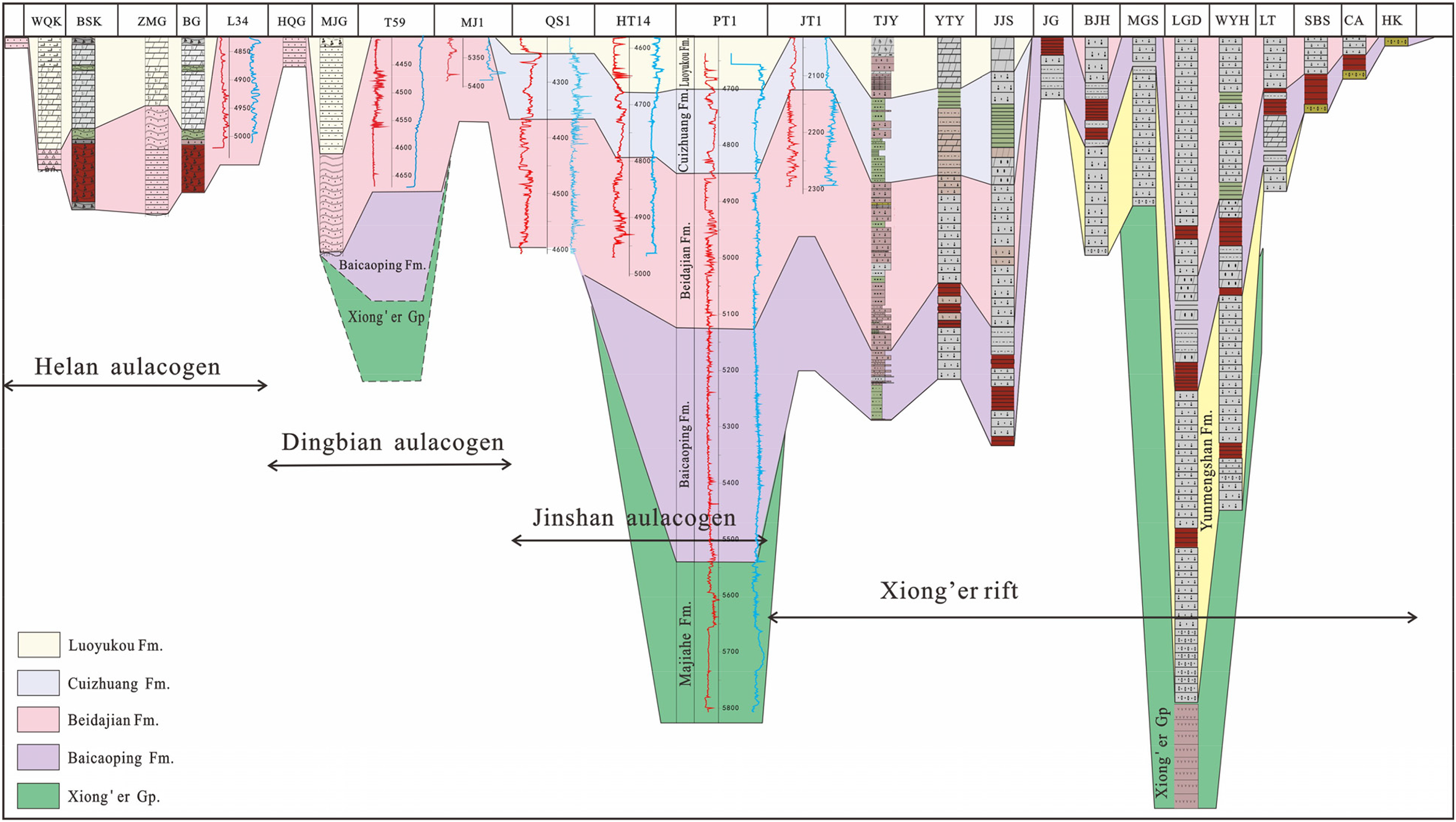
The Ordos Basin, located in the western part of the North China Craton, is a polycyclic superimposed basin developed on the Archaean metamorphic crystalline basement. It has developed in a close relation to the tectonic evolution of the North China Craton, which has been stable since the Lvliang Movement (1.9–1.7 Ga; Li et al., 2000) when it joined the Columbia supercontinent. The final cratonization of the North China Craton ended between 1.9 and 1.85 Ga. Afterward, in the context of the fragmentation of the Columbia supercontinent, Mesoproterozoic aulacogens developed and created the Xiong'er, Yanliao, Bayan Obo, and Ordos rifts. With the Proterozoic rifting, sediments began to fill the rifts in the Ordos Basin. In the early stage of rifting, thick andesitic volcanic rocks were developed. In the late stage of rifting, large intervals of coarse clastic-sedimentary rocks appeared. During the depression period, fine sedimentary rocks deposited. In the epicontinental sea period, carbonate rock began to deposit extensively with large thickness, forming the first sedimentary cover in the Ordos Basin. The Changchengian System is widespread in the Ordos Basin except for a hiatus in the northeastern Ordos–Shenmu–Mizhi area. The dark mudstone of the Changchengian System Cuizhuang Formation, deposited during the depression period, may be the material basis for the fourth potential petroleum system in the Ordos Basin (Figure 1).
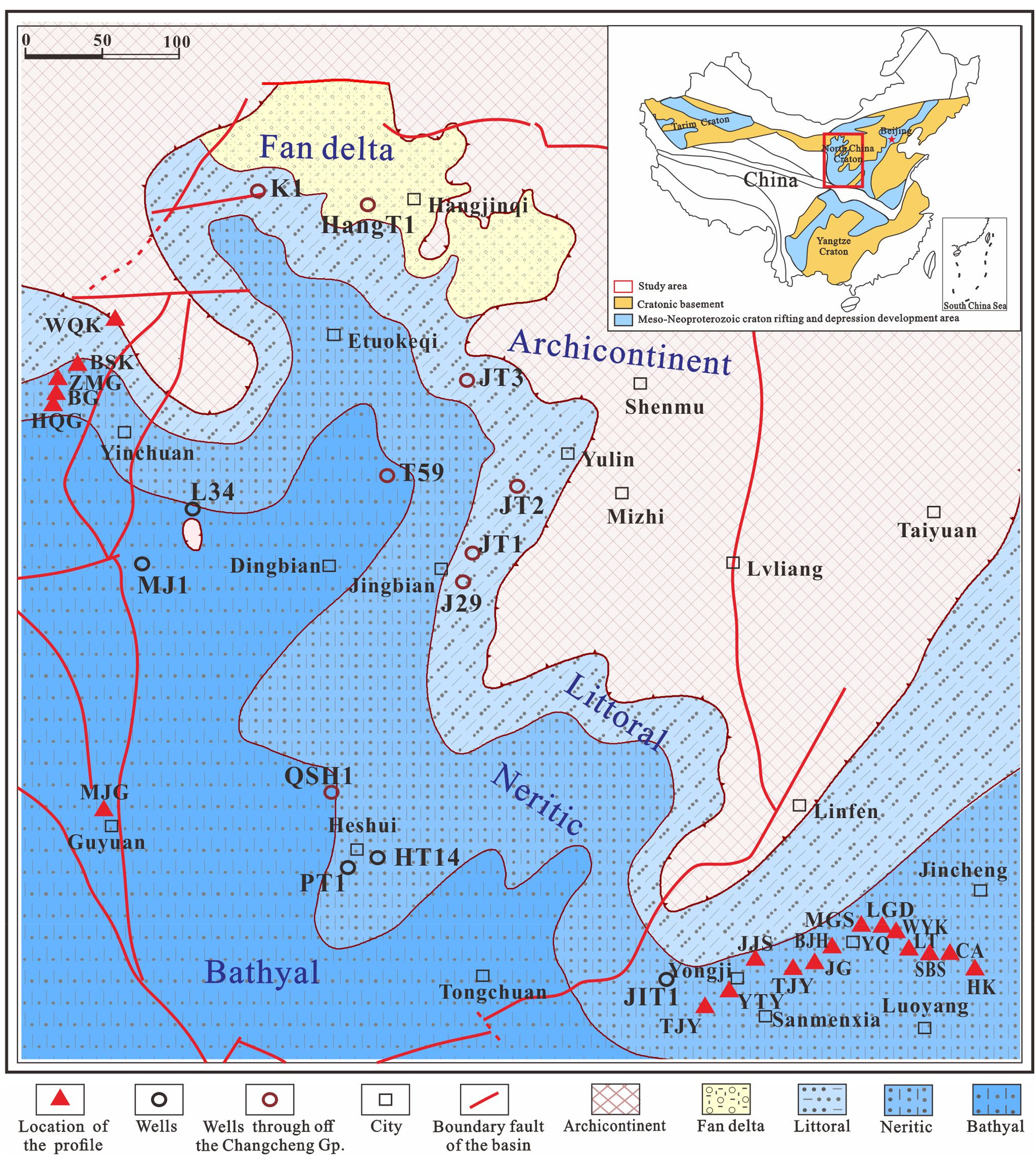
Sedimentary facies of the Mesoproterozoic Changchengian System in the Ordos Basin.
Potential hydrocarbon accumulation in the Changchengian System of the Ordos Basin has been less studied. Until now, only seven exploratory wells have been drilled in the Changchengian System. Most of these wells are in the central and northern parts of the basin where the Changchengian System is thin, and only Well QS1 found complete strata and petrological sequence of the Changchengian System in the southwestern part where it is thick. It is understood that the Proterozoic formations and source rocks are distributed along the aulacogens (Wang et al., 2018). However, how these aulacogens formed and whether they are direct consequences of the Columbia supercontinent breakup remain unresolved. Moreover, the Changchengian System has not been investigated in detail, and the distribution of reservoirs and source rocks remains uncertain. Two-dimensional (2D) seismic and electrical data can be used to predict the deep Changchengian System, but they remain unreliable without calibration by drilling. In 2023, PetroChina Changqing Oilfield Company drilled a deep Well PT1, targeting the Changchengian System in the Heshui area, southern Ordos Basin. According to the drilling data of Well PT1 and the stratigraphic framework built by using the 2D and 3D seismic data recently acquired and reprocessed, the response of the Ordos Basin to the breakup of the Columbia supercontinent was analyzed again, and the aulacogens, strata, and source rocks were further examined. Well PT1 unveiled the mystery of the Changchengian System. It is of great significance for future geological exploration.
Samples and methods
Samples
The samples in this study were mainly collected from Well PT1, a key exploration well drilled in the southern part of the Ordos Basin. For the total organic carbon (TOC) and Rock-Eval pyrolysis, additional samples were incorporated, including dark mudstone core samples of the Changchengian System from other exploratory wells in the basin, and field outcrops in the Yongji area on the southeastern margin of the basin (Figure 1). For field outcrops samples, fresh ones should be prioritized for selection. The samples from the basalt of the Xiong'er Group at 5808–5809 and 5810–5811 m in Well PT1 were selected for zircon U–Pb dating. The samples from the dark mudstone of the Changchengian System Cuizhuang Formation at 4733–4755.5 and 4831–4836.5 m in Well PT1 were taken for laser Raman spectroscopy measurement.
Methods
Laser-ablation inductively coupled-plasma mass spectrometry zircon U–Pb dating
Laser-ablation inductively coupled-plasma mass spectrometry (LA-ICP-MS) zircon U–Pb dating was completed at the Institute of Geology, Chinese Academy of Geological Sciences (Beijing), using a Finnigan Neptune LA-ICP-MS equipped with a Newwave UP213 laser ablation system. Zircon samples free from inclusions and cracks were selected and ablated on single points. To do zircon U–Pb dating, zircon GJ-1 was used as an external standard, and the contents of U and Th were calibrated using zircon M127 as an external standard. The data were processed using ICPMS DataCal 4.3 and ISOPLOT.
TOC and rock-eval pyrolysis
The TOC was measured in the Petroleum Geology Laboratory, School of Earth Sciences, China University of Petroleum (Beijing), using a CS-230 carbon and sulfur analyzer (LECO, USA). Each sample was treated with diluted HCl to remove inorganic carbon and combusted in a high-temperature oxic stream. Organic carbon was converted to CO2 and quantified by an infrared detector, from which the TOC was calculated.
Rock-eval pyrolysis was carried out at the State Key Laboratory of Continental Dynamics, Northwest University, using a ZEIZZ Axio Scope A1 for thin section observation, and an OGE Workstation VI for pyrolysis analysis. Using 100-mg powdered sample (200 mesh), pyrolysis parameters, including S1 (free hydrocarbons), S2 (pyrolytic hydrocarbons), S3 (CO2), and Tmax, were measured in an open system at 600 °C, with an accuracy of ±0.5%.
Bitumen reflectance and laser Raman spectroscopy
Bitumen reflectance and laser Raman spectroscopy were tested at the State Key Laboratory of Continental Dynamics, Northwest University. The bitumen reflectance was measured using a Carl Zeiss TIDASMSP200 spectrometer configured with a Zeiss Axio Scope A1, with the wavelength of 190–720 nm, the spectral resolution less than 7 nm, the wavelength precision of ±1 nm, and the UV (Ultraviolet) and UIS (Ultra-high Intensity Source) photometric accuracies of ±10 mAU. The laser Raman spectroscopy was performed using a Renshaw inVia Reflex confocal Raman spectroscopy at lateral resolution <1 µm, and longitudinal resolution <4 µm (50× lens) along the optical axis. The focus depth was adjustable, and the laser excitation for Raman scanning was 532 nm.
Results
Petrology
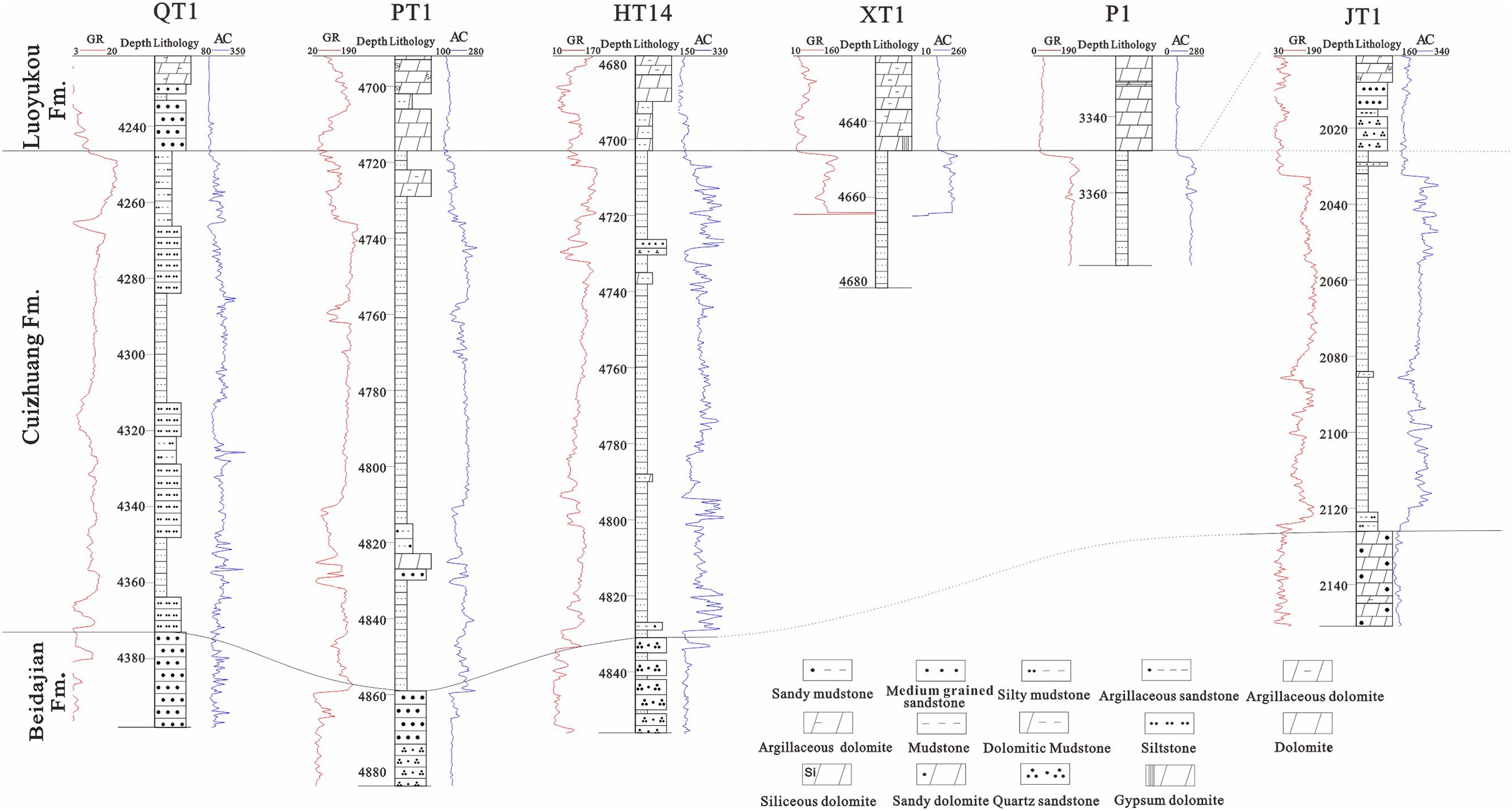
Well PT1 was drilled into the volcanic and volcaniclastic rocks of the Changchengian System Xiong'er Group and terminated at 5818 m. It is the first well that penetrated the complete Changchengian System in the Ordos Basin. The system is subdivided into a tripartite sequence: the Xiong’er Group at the base, the Ruyang Group in the middle, and the Luoyu Group at the top (Figure 2). The Xiong’er Group is composed of volcanic and volcaniclastic rocks, and the core samples are basalt, tuff, and diabase intrusions. The Ruyang Group is composed of terrigenous clastic rocks dominated by quartz sandstone interbedded with thin mudstone, and the core samples from Well PT1 are gravelly sandstone at the bottom of the Baicaoping Formation. The Luoyu Group is dominated by fine shale, argillaceous siltstone, and argillaceous dolomite. The core samples of the Luoyu Group in Well PT1 are interbedded sandstone and mudstone in the middle of the Cuizhuang Formation. Limited by drilling and coring conditions, lithology and stratigraphy were mainly identified through comprehensive observation on drilling cuttings, electrical logs, and stratigraphic correlation with the Yongji area.
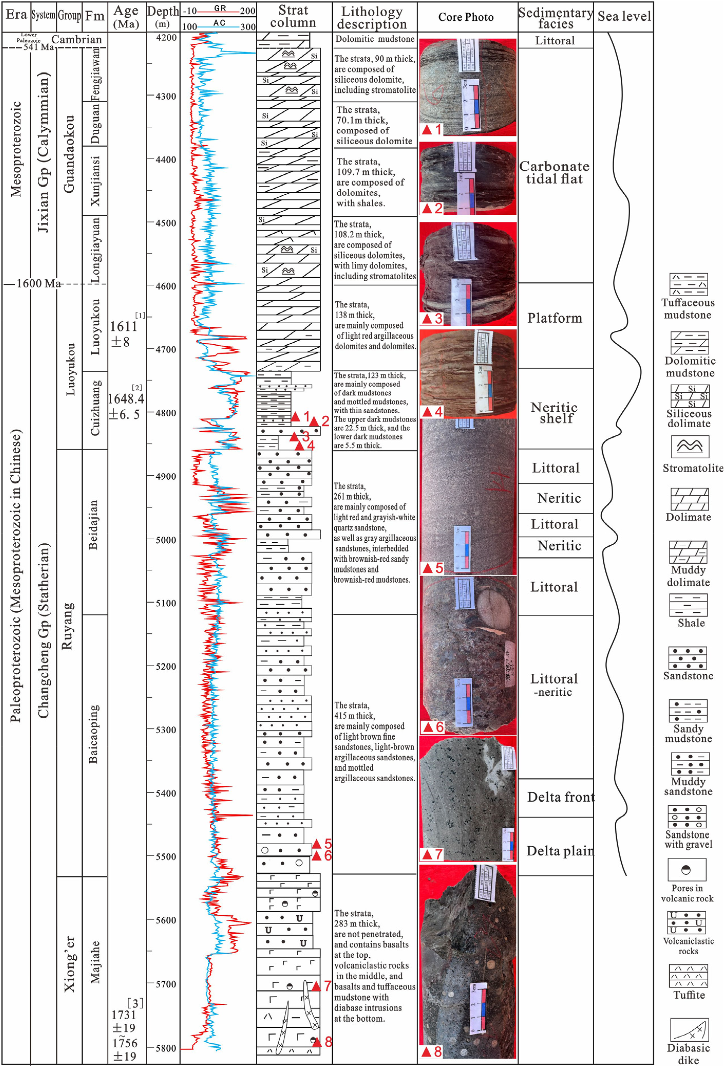
Stratigraphic column of the Mesoproterozoic and Neoproterozoic in Well PT1 showing changes in lithology and sedimentary environment. [1] The age was from magmatic zircon of the tuff from the Luoyukou Formation in Ruzhou area (Su et al., 2012). [2] Zhao et al. (2019); Pan et al. (2020). [3] This study.
The Xiong’er Group
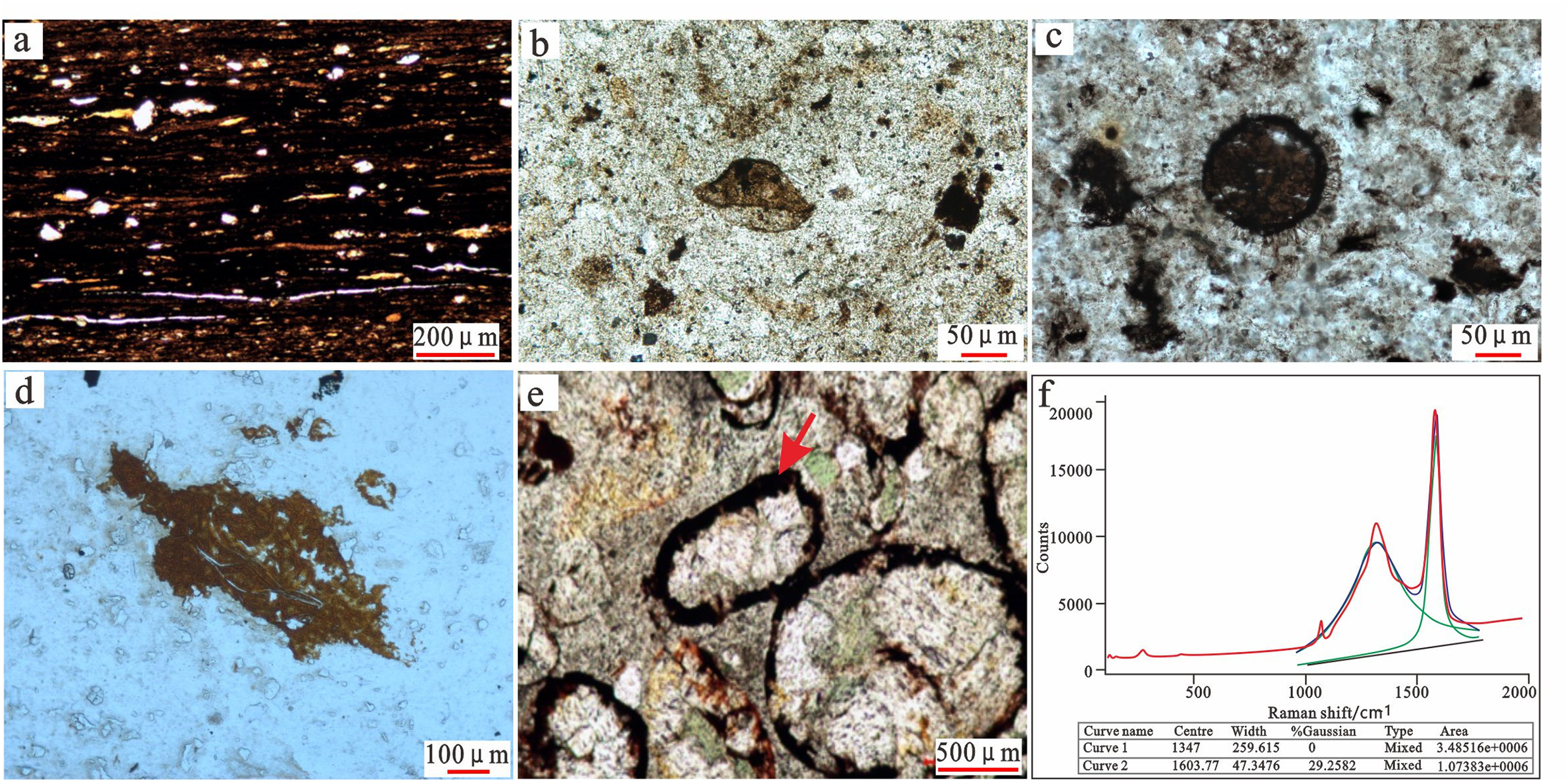
Well PT1 encountered the Xiong'er Group by 283 from 5535 m, but did not penetrate it. The interval encountered includes basalt, tuff, volcaniclastic rocks, and diabase intrusions. The lithologic sequence can be divided into three sections: tuff (Figure 3(a)), gray-black basalt (Figure 3(b)), and diabase intrusions (Figure 3(c) and (f)) in the lower section; volcaniclastic rock in the middle section, according to logging interpretation (not cores); and multiphase basaltic eruptions and superimposed multiphase pillow lavas in the upper section, as clearly shown by imaging logs. The tuff is highly bright and tight (Figure 3(g)). The basalt cores reflect vesicular and amygdaloidal textures reaching 0.8 mm, and contain amygdaloidal pores filled with calcite. Phenocrysts are generally plagioclase feldspar with a vitroporphyritic texture (Figure 3(d)). Feldspar crystals were observed in the tuff, and some of them have been chloritized (Figure 3(e)).
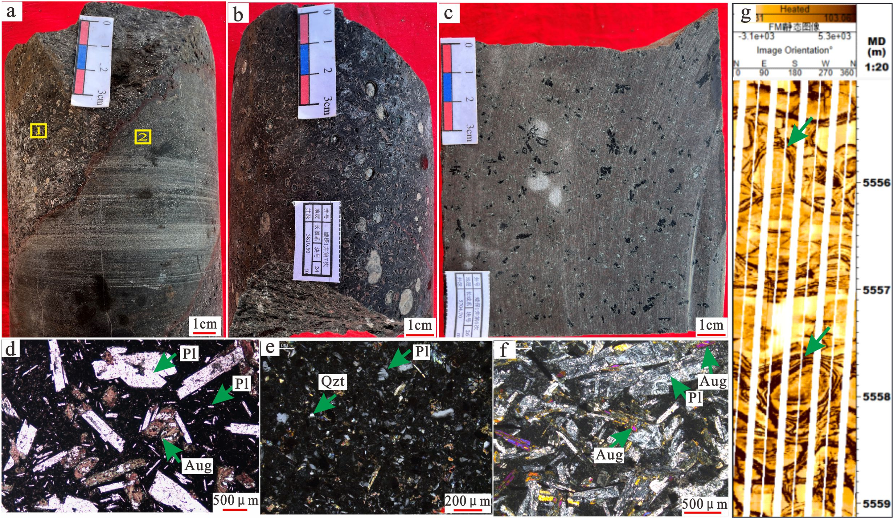
Images showing the lithology of the Xiong'er Group in Well PT1. (a) Tuff and basalt of Majiahe Formation, 5809.7 m. (b) Basalt with an amygdaloidal texture, 5810.5 m. (c) Pyroxene, 5704.7 m. (d) Basalt with a hyalopilitic texture, randomly distributed plagioclase phenocrysts, chloritized pyroxene phenocrysts, and filled with volcanic glass and plagioclase microcrystals, microscopic image at point 1 in (a) (e) Tuff with quartz and feldspar crystals, microscopic image at position 2 in (a). (f) Pyroxene, microscopic image of (c). (g) Multiphase pillow basalts, logging image, 5555–5559 m.
The Ruyang Group
The Ruyang Group comprises the Baicaoping and Beidajian Formations. In Well PT1, the Baicaoping Formation overlies the Xiong'er Group unconformably. PT1 is the first exploratory well that drilled into the Baicaoping Formation which is a set of thin interbeds of sandstone and shale according to mud logging interpretation, indicating a frequent fluctuation of the sea level, and consistent with that in the Zhongtiao Mountains of the Yongji area (Figure 4(a) and (d)). The sandstone contains cross-bedding that is wedge-shaped, tabular, and herringbone (Figure 4(b)), and belongs to littoral deposits. Cores taken at the bottom of the Baicaoping Formation in Well PT1 are purple-red gravelly sandstone (Figure 4(c)). According to logging interpretation, the interval is 4 m thick and belongs to near-source delta deposits. It transits upward into sand–mud interbeds, indicating a deep-water environment.
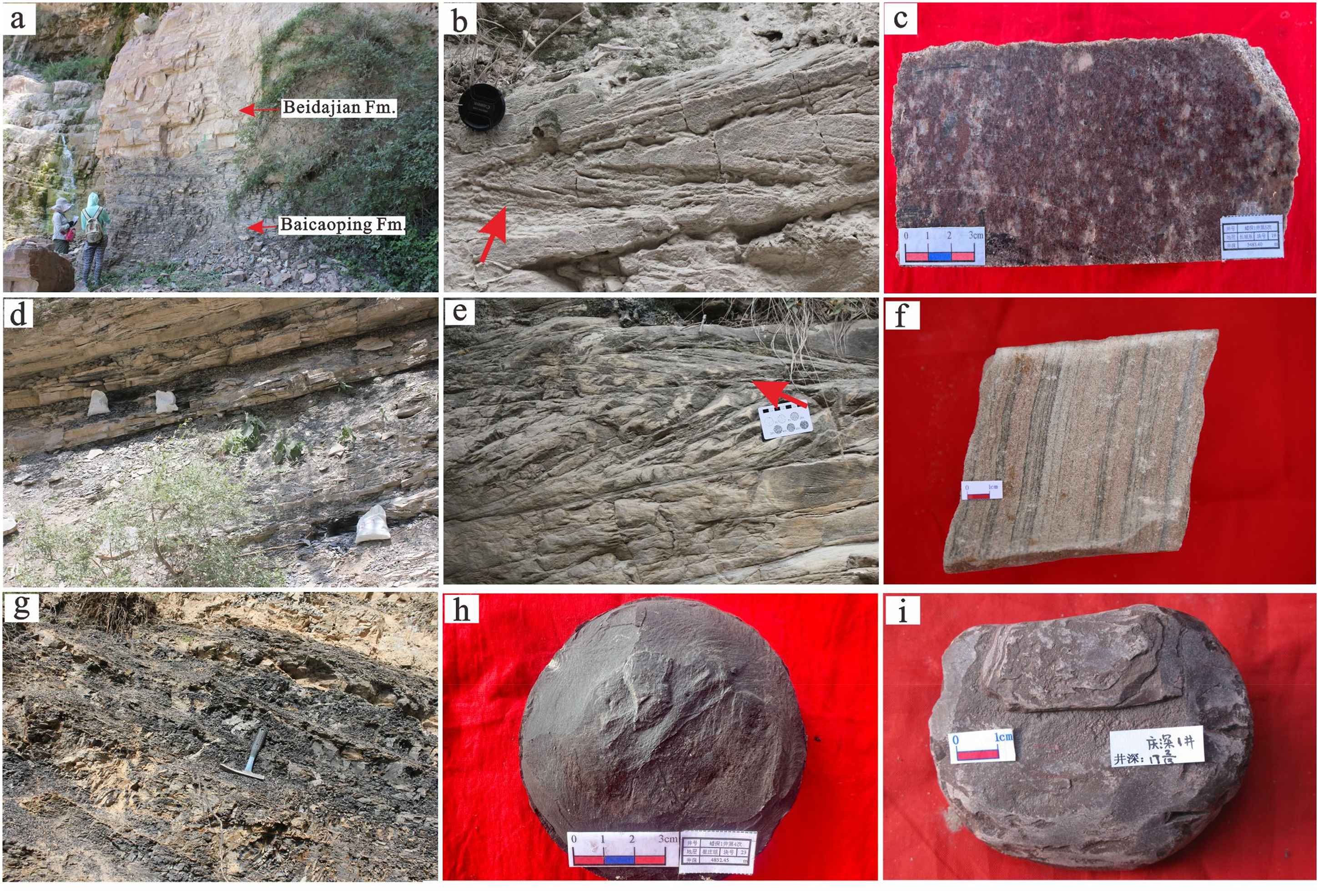
Photos showing the lithology of the Ruyang and the Luoyu Groups in the Ordos Basin and its periphery. (a) Baicaoping and Beidajian Formations, Yongji area. (b) Large-scale herringbone cross-bedding, Baicaoping Formation, Yongji area. (c) Pebbled coarse sandstone, Baicaoping Formation, 5481.70 m, Well PT1. (d) Interbeds of sandstone and mudstone, Baicaoping Formation, Yongji area. (e) Herringbone cross-bedding, quartz sandstone, Beidajian Formation, Yongji area. (f) Quartz sandstone, Beidajian Formation, 4177.30 m, Well JT1. (g) Shale and sandstone interbeds, Cuizhuang Formation, Yongji area. (h) Gray-black mudstone, Cuizhuang Formation, 4830.15 m, Well PT1. (i) Muddy micrite dolomite, Luoyukou Formation, 4229.05 m; Well QS1.
Cuttings from Well PT1 show that the Beidajian Formation consists of light red quartz sandstone and thin layers of brown red mudstone. The quartz sandstone is relatively pure, and easily distinguished from the frequent sand–mud interbeds of the Baicaoping Formation (Figure 2). It is a set of littoral deposits overlying the Baicaoping Formation conformably. Compared with the Baicaoping Formation, the Beidajian Formation depositing in shallower water is the most widespread in the Changchengian System of the Ordos Basin.
The Luoyu Group
The Luoyu Group includes the Cuizhuang Formation and the Luoyukou Formation upward. The Cuizhuang Formation is interbeds of fine sandstone, mottled mudstone, and gray-black shale (Figure 4(g) and (h)), as well as a small amount of argillaceous dolomite. It overlies the Beidajian Formation conformably. The mudstone thickens significantly in the Cuizhuang Formation.
The Luoyukou Formation, as the top-most part of the Changchengian System, is lithologically uniform as revealed by drilling data. It is composed of thin purple-red argillaceous dolomite and dolomite depositing in a restricted platform environment (Figure 4(i)), indicating distinctive lithology. The mudstone in the upper part decreases gradually. The Luoyukou Formation is conformable with the underlying Cuizhuang Formation, but parallelly unconformable with the overlying banded siliceous dolomite of the Jixianian System.
LA-ICP-MS zircon U–Pb ages
Volcanic and volcaniclastic rocks of the Xiong’er Group were encountered below 5535 m in Well PT1. An abrupt contact between basalt and tuff was observed, where a scour surface of soft tuff deposits was found (Figure 5(a)). This indicates that the eruption of basaltic magma occurred when, but not after, the tuff was deposited, and the age of the basalt may represent the stratigraphic age. LA-ICP-MS zircon U–Pb dating was carried out on the basalt samples from the intervals of 5808–5809 and 5810–5811 m in Well PT1. The zircon grains are similar in the samples from the two intervals, and they are mostly light yellow to brown. Some grains have a relatively good euhedral degree, and show bipyramidal and columnar shapes, with typical magmatic rhythmic zones (points 5 and 37, Figure 5(h)), which are primary magmatic zircons. Some zircons (points 10, 11, and 17, Figure 5(h)) have obvious residual cores which may be inherited or captured. In order to obtain more zircon information and remove the interference from inherited zircons on dating, the obvious magmatic zircon zones were selected for analysis. Although data fitting is imperfect, the results are still referential considering limited drilling samples. A total of 29 zircon spots in the basalt at 5808–5809 m were analyzed, and their weighted mean age is 1731 ± 27 Ma. A total of 34 zircon points in the basalt at 5810–5811 m were analyzed, and their weighted mean age is 1756 ± 19 Ma (Figure 5(d) to (g)). The ages point to multistage basaltic eruptions and, when compared with the regional volcanic record of Zhao et al. (2004a, 2004b), assign the flows to the Majiahe Formation of the Xiong’er Group.
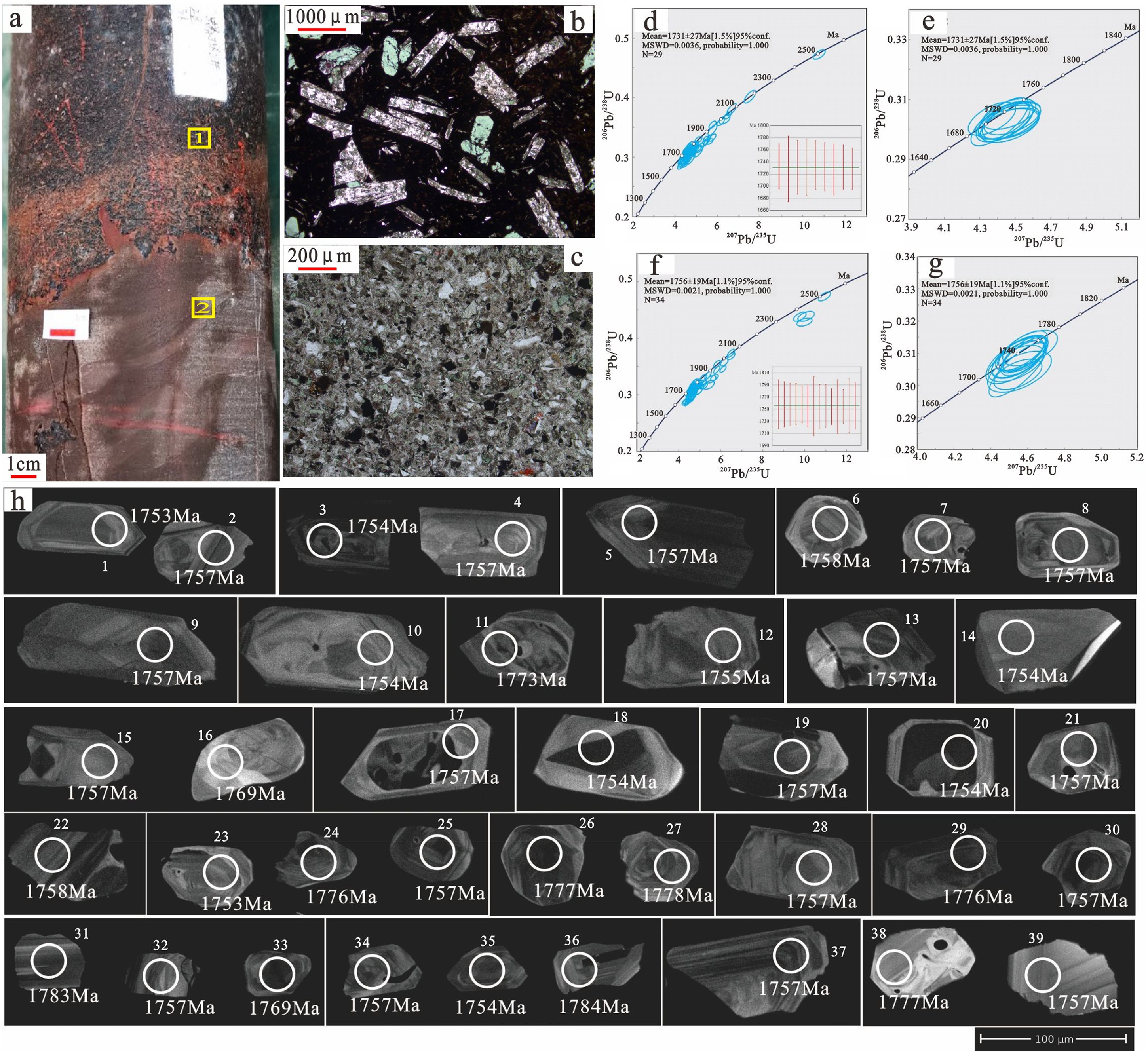
Zircon U–Pb spectra of basalts in the Majiahe Formation of the Xiong’er Group in Well PT1. (a) Contact between tuff and basalt, core, 5811.0 m, Well PT1. (b) Pyroxene altered to chlorite, with pyroxene crystals, basalt, thin section at position a. (c) Tuff, thin section at position a. (d)–(g) Zircon U–Pb spectra of basalt, 5808–5811 m. (h) Representative zircon cathodoluminescence images of basalt, points 1–20 at depth ranging from 5808 to 5809 m, and points 21–39 from 5810 to 5811 m.
Organic geochemistry
TOC and pyrolysis analysis
Well PT1 encountered dark mudstone totally 28 m thick in two parts of the Cuizhuang Formation. The upper part is 22.5 m thick (at 4732–4754.5 m), with TOC of 0.08–0.38% (avg. 0.17%, 20 samples), S1 + S2 of 0.04–0.67 mg/g (avg. 0.15 mg/g), and Tmax of 334–581 °C (avg. 464.6 °C, 19 samples). The lower part is 5.5 m thick (at 4826.96–4827.96 m and 4829.9–4834.4 m), with a TOC of 0.21–1.58% (avg. 0.84%, 25 samples, of which 65% have TOC >0.5%), S1 + S2 of 0.15–2.21 mg/g (avg. 0.56 mg/g), and Tmax of 387–583 °C (avg. 500.5 °C, 13 samples). The hydrocarbon-generating potential is low, which may be related to the fact that the mudstone has been highly to over mature and the hydrocarbon-generating peak has ended (Table 1).
TOC and pyrolysis analysis of dark mudstones in the Changchengian System within and around the Ordos Basin.
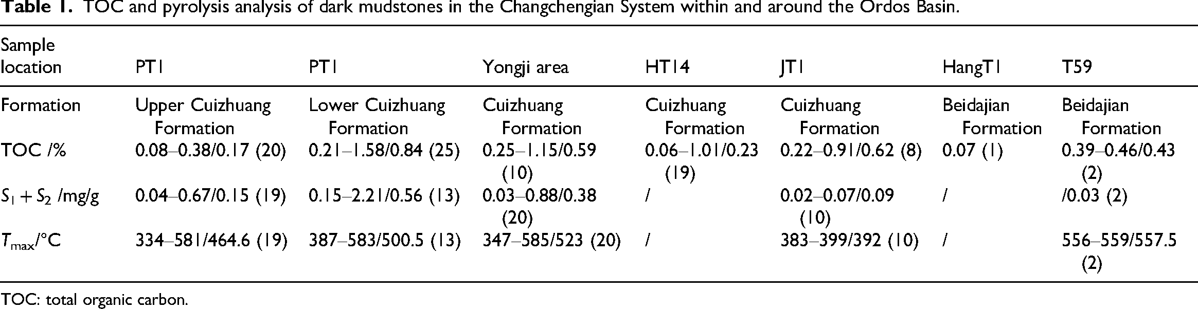
TOC: total organic carbon.
Maturity
Conventional maturity assessment methods are ineffective for the target formations which are deeply buried and highly mature. In this study, equivalent vitrinite reflectance and bitumen reflectance by laser Raman spectroscopy were employed for maturity assessment.
The formula for equivalent vitrinite reflectance (Feng and Chen, 1988) is:
The formula for laser Raman spectroscopy reflectance (Tian et al., 2021; Wilkins et al., 2014) is:
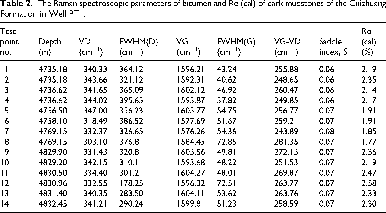
For the samples, the VRo calculated by BRo ranges from 2.03% to 2.49%, with an average of 2.23% (five values), and the equivalent Ro values measured by laser Raman spectroscopy are between 1.70% and 2.58%, with a prevalence >2.0% and an average of 2.18% (14 values, Table 2). The results of the two methods are almost consistent. The equivalent vitrinite reflectance of the bitumen indicates that the dark mudstone is mature to over-mature (Figure 6).
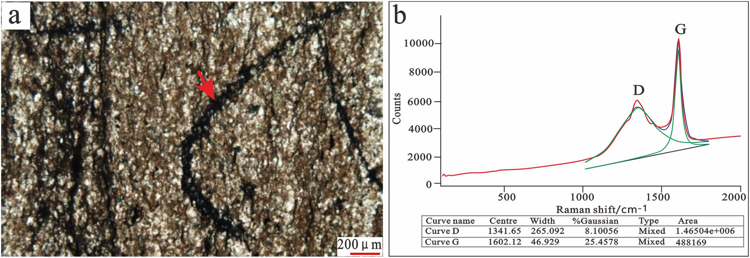
Representative Raman spectra of bitumen in the Cuizhuang Formation, core sample, 4769.15 m, Well PT1. (a) Microscopic image of the solid bitumen inclusion. (b) Laser Raman spectrum at the position of the arrow in (a).
The Raman spectroscopic parameters of bitumen and Ro (cal) of dark mudstones of the Cuizhuang Formation in Well PT1.
Discussion
A three-part stratigraphic sequence of the Changchengian System
Due to differences in sedimentation, tectonic systems, and outcrops, the stratigraphic naming rules in different regions are chaotic. Paleo–Mesoproterozoic successions are preserved in five main regions: the Yanliao aulacogen, the Xiong’er aulacogen, the Luonan area at the southern margin of the Ordos Basin (Qinling Mountains), the western margin of the Ordos Basin, and the Bayan Obo aulacogen (Yinshan Mountains) (Lv et al., 2020; Su, 2016; Wang et al., 2018; Zhao et al., 2019). The “southern margin of the Ordos Basin” mentioned in previous studies is actually located in the Qinling Mountains area. During the Paleo–Mesoproterozoic sedimentary period, it was close to the Qinling Ocean, with relatively deep water and almost in a continuously sedimentary area. The Paleo–Mesoproterozoic strata in the North China Craton are believed to follow an aulacogen sedimentary model. Sedimentation of these strata began with the invasion of seawater, like the formation of the aulacogens in the Early Proterozoic, and they had similar sedimentary environments. The Qinling orogenic belt started collisional orogeny in the Neoproterozoic, and the strata suffered from variable degrees of deformation and metamorphism. However, the stratigraphic sequence of the Xiong'er aulacogen is continuous and has a similar tectonic setting to that of the Ordos Basin. Therefore, the stratigraphic naming rules and lithologic correlation in the Zhongtiao Mountains of the Yongji area in the western part of the Xiong'er aulacogen are applied to the Ordos Basin. This gives a more comprehensive understanding of the strata in the basin.
The stratigraphic framework and lithology of the Changchengian System in the Ordos Basin were completely described for the first time, and a standard well for the stratigraphic sequence was established. The three-part stratigraphic sequence of the Changchengian System shows remarkable lithologic characteristics that can be easily correlated. In the context of the Columbia supercontinent breakup, the whole Ordos Basin was in an extensional environment that caused a series of basement faults. The Jinshan aulacogen was developed in the Heshui area and deposited with the Xiong’er Group. Well PT1 encountered but did not penetrate the volcanic lava with volcaniclastic rock in the Majiahe Formation of the Xiong’er Group. The development and distribution of the underlying Jidanping, Xushan, and Dagushi Formations are still unclear, and need to be confirmed by more exploration activities. As rifting stopped and sedimentation began, the basin started depressing, and then the Ruyang Group and the Luoyu Group deposited. The Ruyang Group is almost littoral deposits into the Baicaoping and Beidajian Formations which are almost terrigenous clastic rocks with thin carbonate layers. The thickness of the Baicaoping Formation changes significantly inside and outside the basin. For example, it is 415 m in Well PT1 and about 170 m in the Zhongtiao Mountains. The Baicaoping Formation is mainly distributed in the Dingbian and Jinshan aulacogens. The Beidajian Formation is extensively distributed, except for the northeastern Ordos–Shenmu–Mizhi area. Several wells have encountered widespread quartz sandstone of the Beidajian Formation, thick from tens to thousands of meters (in Well HangT1), and the lithology is uniform and stable. The Luoyu Group developed the Cuizhuang and Luoyukou Formations after a transgression–regression cycle. The Cuizhuang Formation is of shallow shelf facies depositing with transgression, including shale, mudstone, argillaceous siltstone, and fine sandstone. The Luoyukou Formation consists of carbonate rock of open platform facies depositing with regression, and is dominated by argillaceous dolomite. The Cuizhuang Formation within and around the Ordos Basin is consistent in lithology, stably distributed and 120–140 m thick, reflecting a shallow shelf sedimentary environment. The dark mudstone of the Cuizhuang Formation with high TOC is potential Proterozoic source rock. Drilling data suggest that the Luoyukou Formation is stably distributed, and about 130 m thick. The Mesoproterozoic strata in Well PT1 recorded a complete sedimentary process from rifting to depressing with the supercontinent breakup.
A tectonic-sedimentary framework from rifting to depressing
The response of the North China Plate to the breakup of the Columbia supercontinent is reflected by a series of magmatic events happening with the Early Changchengian System. Major magmatic events include the Taihang–Lvliang mafic dyke swarm and Xiong'er volcanic rocks at ca. 1.78 Ga, and the Miyun–Beitai mafic dyke swarm a little later (at 1.76–1.73 Ga) (Figure 7). Preliminary studies found that the volcanic formations of the Xiong’er Group cropped out of the Xiong’er rift system in the Zhongtiao Mountains and the Qianyang area of Baoji at the southeastern margin of the Ordos Basin, and the Lvliang Mountain in the central part of the basin (Peng, 2015, Figure 7). As a result, there developed the Xiong’er rift, and the Jinshan, Dingbian, and Helan aulacogens from southeast to northwest (Gong et al., 2016, Figure8), according to 2D seismic data. Limited by deep drilling data, the development of the volcanic rocks in the Xiong’er Group has not been confirmed, and the properties and sizes of the aulacogens have not been clarified.
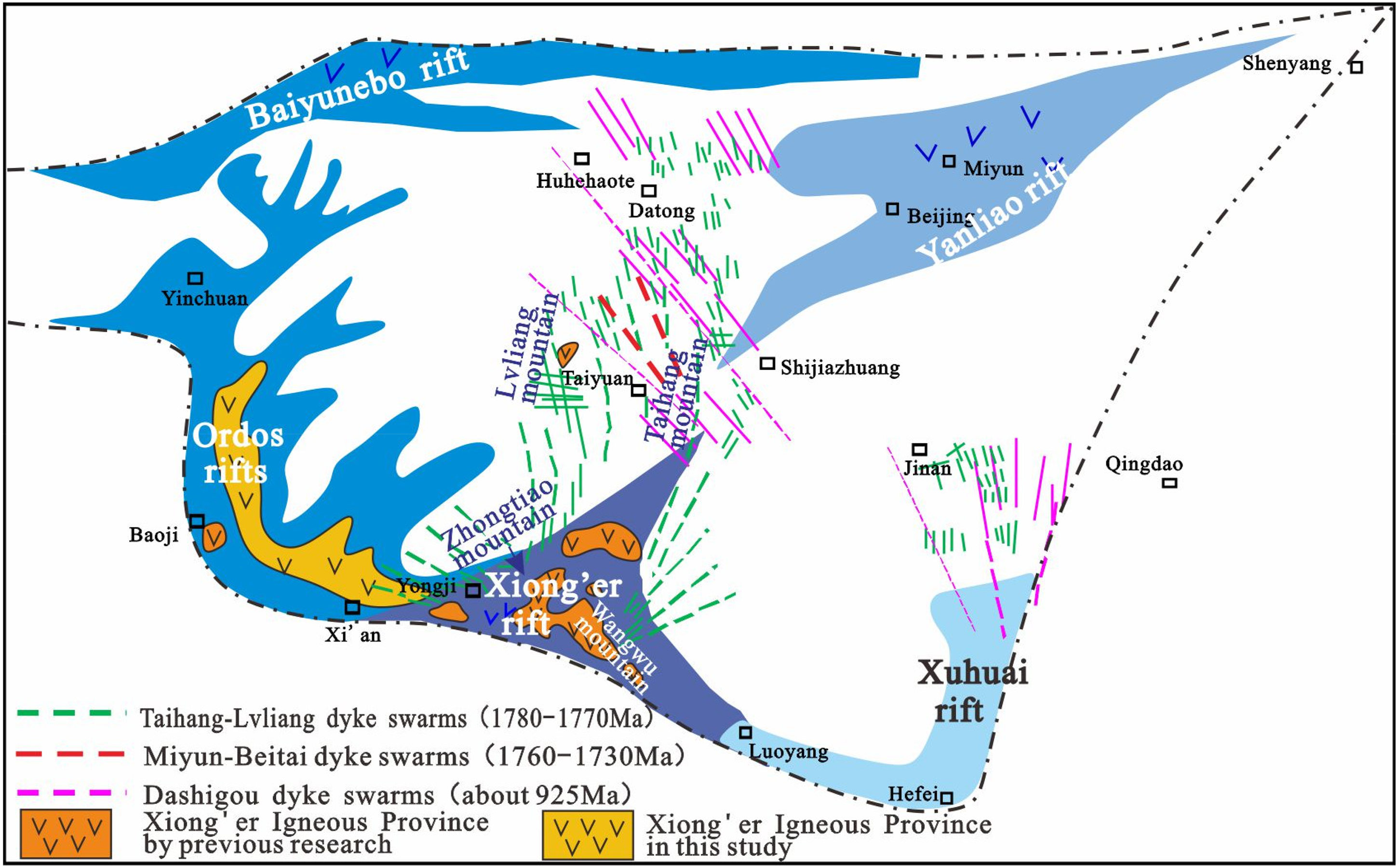
Distribution of major Meso–Neoproterozoic dike/sill swarms and volcanic rocks in the North China Craton (modified from Zhai et al., 2014).
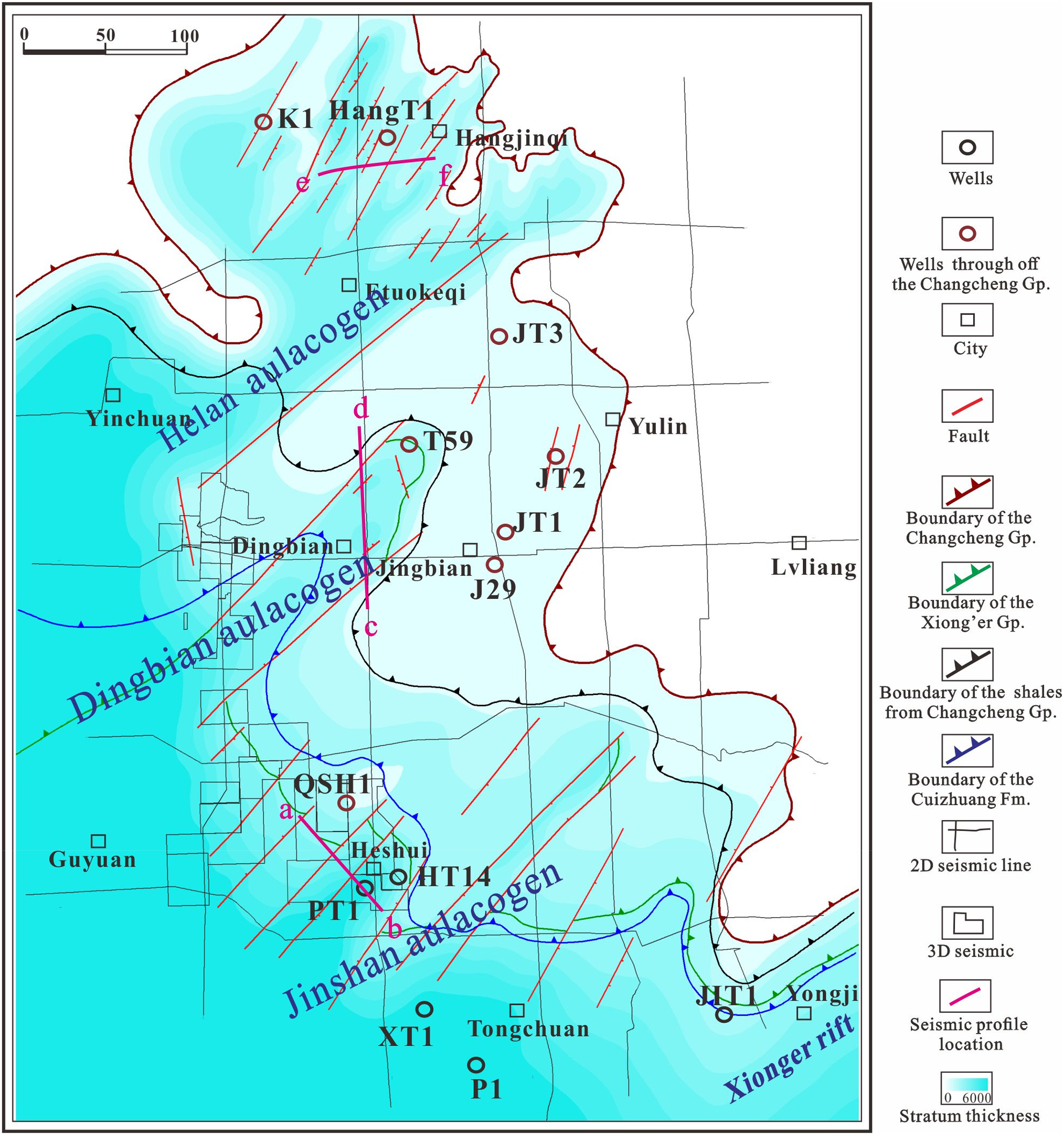
Thickness map of the Mesoproterozoic Changchengian System in the Ordos Basin.
Age and geological significance of deep volcanic rocks
According to the Proterozoic sedimentary-volcanic sequence (Lv et al., 2020; Zhao et al., 2007), the three-part stratigraphic sequence of the Changchengian System in Well PT1 exhibits distinct characteristics. The Luoyu Group and the Ruyang Group in Well PT1 are well correlated in the Zhongtiao Mountain area of the Xiong'er rift (Pan et al., 2020). Moreover, the clastic rock of the Baicaoping Formation is unconformably overlies the basalt of the Xiong’er Group. The unconformity surface shown by strong and deep reflections on 3D seismic sections and relatively continuous. According to the description of the Xiong'er Group (Zhao et al., 2001, 2007), it is divided into four formations vertically: (1) the Dagushi Formation, which is composed of fan delta and fluvial and lacustrine gravelly sandstone, sandstone, and mudstone; (2) the Xushan Formation, which consists of basaltic–andesitic and andesitic lava, dacite and rhyolitic lava, and a small amount of basaltic lava; (3) the Jidanping Formation, which is composed of more dacitic–rhyolitic lava and less basaltic andesitic lava; and (4) the Majiahe Formation, which is the combination of volcanic lava and clastic rock, where the volcanic lava is mainly basaltic–andesitic and andesitic, with a small amount of rhyolite, and multiple interbeds of clastic and volcaniclastic rocks with varying thickness. Previous studies suggested that the Ruyang and Luoyu Groups are mainly composed of clastic and carbonate deposits, but no volcanic or volcanic clastic rock. Therefore, based on the correlation of stratigraphic sequences, it is considered that the characteristic assemblage of volcanic and pyroclastic rocks following the sedimentary-volcanic sequence in Well PT1 is the Majiahe Formation. The ages of the basalts at 5808–5809 and 5810–5811 m at the bottom of Well PT1 are concentrated at 1731 ± 27 and 1756 ± 19 Ma, respectively. These ages are similar to the age constraints of 1.80–1.75 Ga for the Xiong'er Group proposed by Zhao et al. (2004b) and Zhai et al. (2014). Therefore, based on comprehensive judgment, the sedimentary-volcanic sequence in Well PT1 is identified as the Majiahe Formation of the Xiong'er Group. Different from the lithologic association of basaltic andesite and andesite in the Xiong’er rift, the Xiong’er Group in the study area is more basic, with basalt in dominance. The exact origin remains to be discussed.
Based on the study on the Paleo–Mesoproterozoic sedimentary characteristics of the North China Craton, the elemental characteristics of the volcanic rocks of the Xiong'er Group, and the mafic dyke swarms of the same period (Zhao et al., 2015), it is believed that the volcanic rocks of the Xiong'er Group usually exhibit “island arc geochemical characteristics,” with the depletion of high-field-strength elements and enrichment of large-ion lithophile elements. Both the whole rock εNd(t) and the zircon εHf(t) values show the characteristics of an enriched mantle and have suffered from crustal material contamination to variable degrees (He et al., 2009, 2010a, 2010b; Wang et al., 2010; Zhao et al., 2002). Some mafic dyke swarms in the North China Craton also exhibit similar petrological and geochemical properties (Hu et al., 2010; Peng et al., 2007, 2008; Peng, 2015). Moreover, the mafic dykes of the same period are iron-rich (the iron content is ˃10% generally, and up to 20% locally) and silicon-poor (the SiO2 content is generally around 1%). This is significantly different from the basic rocks formed with the silicon-rich and iron-poor trend according to the Bowen trend, indicating opposite iron-rich evolution (Fenner trend). Iron-rich mafic dykes were first discovered in typical midocean ridge spreading centers and later in back-arc basins and continental rift environments (e.g. the Afar Rift in Ethiopia and the Red Sea Rift). Therefore, the volcanic rocks of the Xiong'er Group and the contemporary mafic dyke swarms in the Paleo–Mesoproterozoic, around 1.75–1.80 Ga, are considered as the products of a tensional-rifting environment. The period almost coincides with the breakup of the Columbia supercontinent. By comparing the mafic dyke swarms in the North China Craton with those in the Indian Plate in the same period, some studies suggest that there is a certain connection between them during the Paleo–Mesoproterozoic (Hou et al., 2008; Peng, 2015; Peng et al., 2005; Raju et al., 2024; Zhang et al., 2012). It is speculated that the volcanic activities during the period were related to the breakup of the Columbia supercontinent.
The age of the Xiong'er Group is mainly determined from the volcanic rocks of the Xiong'er Group in the Xiong'er Mountains and Waifang Mountains areas (Zhao et al., 2004a). It is widely accepted that the Xiong'er Group was formed during the Paleoproterozoic (or the Mesoproterozoic in China), ca. 1.80–1.75 Ga, but the start and end of volcanism may vary in these areas. Regional geological and aeromagnetic data show that the Xiong'er Group is mainly distributed in the Xiong'er three-armed rift system. Based on the age and occurrence of the mafic dyke swarms (1.78 Ga) in the North China Craton, Zhai et al. (2014) concluded that the original magma center was located in the Xiong'er rift at the southern margin of the North China Craton and radiated toward north- and westward. The Xiong'er Group from Luonan in Shaanxi Province to Mianchi in Henan Province is thick, indicating that it is close to the center of the mantle plume. With the development of the rift, the Xiong'er Group radiated westward, associated with a series of half-graben faults formed at the southern margin of the Ordos Basin, which provided a favorable space for Mesoproterozoic sediments. In addition to the Xiong'er rift system, the Xiong'er Group is exposed locally in the western Qianyang area and the central Lvliang Mountains area. At the first time, the discovery of the volcanic rocks in the Xiong’er Group confirmed the Jinshan aulacogen as a rift system, and revealed that the Ordos Basin underwent the breakup of the Columbia supercontinent. The zircon age of the basalt in the Xiong’er Group in Well PT1 is similar to the mafic dyke swarm (1.76–1.73 Ga) in the Miyun–Beitai area in the central North China Craton. This indicates that the Jinshan aulacogen was split roughly at the same time as the Miyun–Beitai area (Zhai et al., 2014), and a little later than the Xiong’er rift.
Rifts followed by depressions, reflected by the Changchengian System
Mesoproterozoic sedimentation in the Xiong'er rift and its periphery underwent three stages: early continental rift, late continental rift, and passive continental margin with depression. With early rifting, the Xiong'er Group started to deposit. At the beginning, the Dagushi Formation coarse clastic rocks rapidly accumulated. As the mantle plume rapidly uplifted, the lithosphere was stretched and thinned, and magmatic materials erupted to the surface and the seabed along the three-armed rift, forming volcanic and pyroclastic rocks of the Xushan Formation and the Majiahe Formation. After the deposition of the Xiong'er Group, late rifting began in a transgressive environment, and the Xiaobeigou Formation and the Yunmengshan Formation deposited. However, these formations are absent in the Yongji area, indicating that rifting became weak, and sedimentation only occurred in the center of the rifted depression. Finally, passive continental margins appeared, and clastic and carbonate rocks of the Ruyang Group and the Luoyu Group deposited in the Changchengian System.
Faults in the Jinshan aulacogen were identified based on 3D seismic interpretation and 2D inversion of resistivity profiles in the Ordos Basin. Subsequently, the tectonic-sedimentary differential pattern of the Changchengian System was defined through well (PT1)-to-seismic calibration. Similar to the evolutionary process of the Xiong'er rift, the pattern is characterized by rifts followed by depressions. In the context of the breakup of the Columbia supercontinent, aulacogens were controlled by major extensional basement faults striking in SW–NE (Figure 8), which defined the early deposition of the Changchengian System. The depositional rate (Figure 9) shows that the Xiong’er period (1800–1750 Ma) corresponds to the opening and filling of the rift, when tectonic subsidence took place rapidly at 20–100 m/Myr, giving rise to thick volcanic and volcaniclastic rocks of the Xiong’er Group. Following a rapid filling process for around 50 Ma, a depressional stage with stable regional subsidence started. Controlled by faults inside the Changchengian System, deposition occurred at 10 m/Myr, forming the Ruyang and Luoyu Groups dominated by clastic and carbonate rocks. Clearly, the sedimentary pattern is characterized by rifting followed by depressing. The boundary between rift and depression is marked by a regional unconformity between the Xiong’er Group Majiahe Formation basalt and the Ruyang Group Baicaoping Formation clastic rock. The unconformity shows strong reflection responses from deep layers on seismic sections (section a and b, Figure 10), and is traceable laterally.
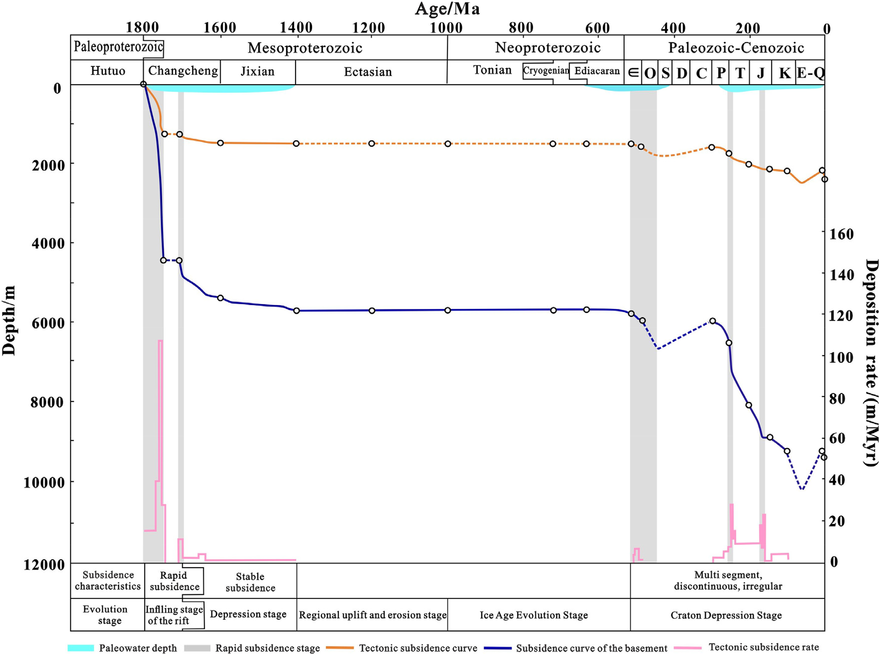
Tectonic subsidence in Well PT1.
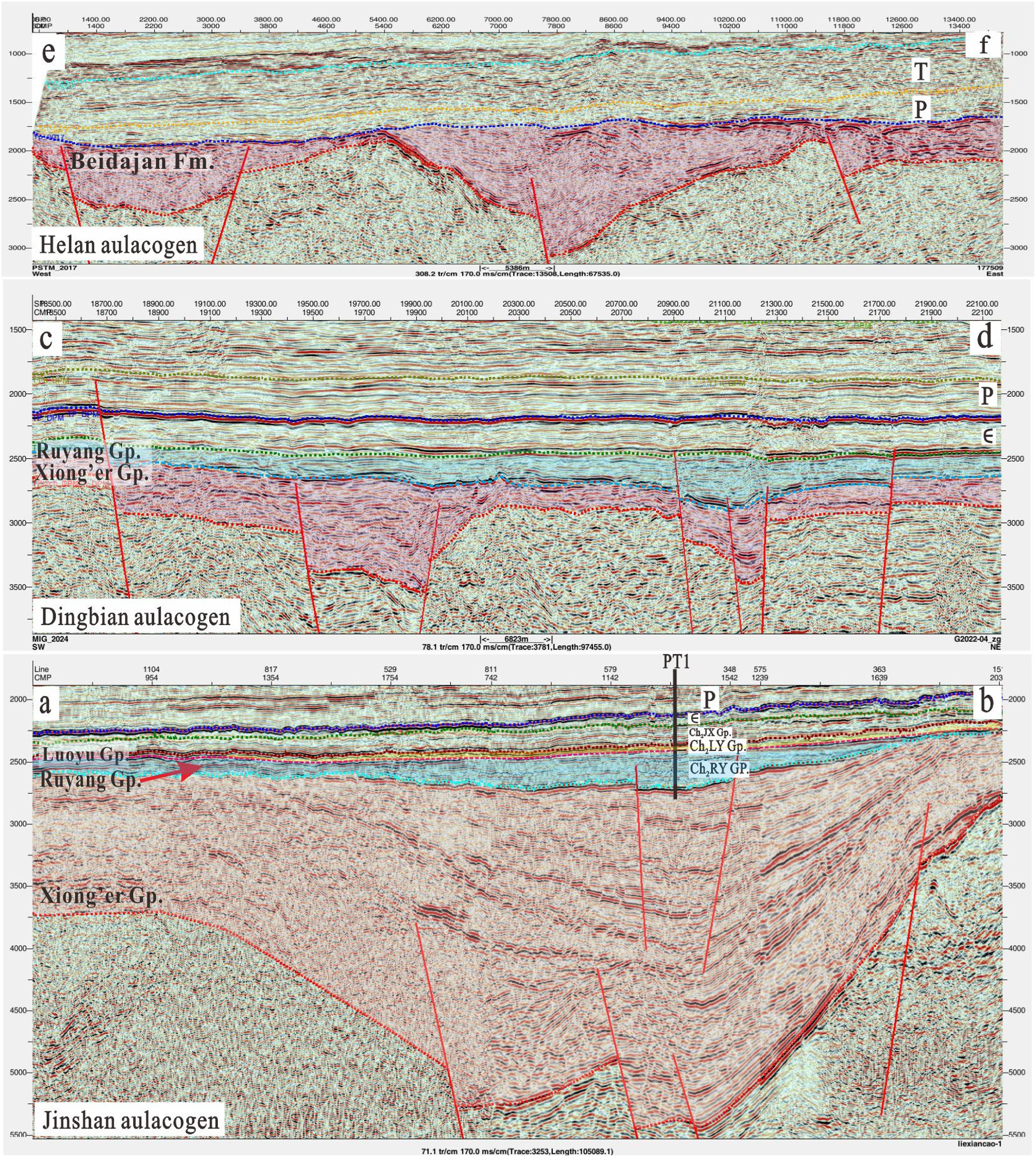
Seismic profile of the Proterozoic aulacogens in the Ordos Basin (profile location shown in Figure 8).
Rifting intensity decreased from south to north
The scales of the aulacogens were ascertained by seismic data. Based on seismic reflections and well (PT1)-to-seismic calibration, major reflectors, the bottom of the Changchengian System, the distribution and thickness of the Xiong’er Group were predicted, and the response intensity of every aulacogen to the breakup of the Columbia supercontinent was analyzed. The strong magnetic crystalline basement such as the Archean gneisses is characterized by chaotic reflections on seismic profiles. The boundary between the basement and the overlying Xiong’er Group corresponds to a strong peak reflection, and it is regionally stable and traceable laterally. The results show that the Jinshan aulacogen in the southwest is adjacent to the Qin-Qi Trough, covers a large area, and develops basement faults. The Xiong’er Group has a distinct rift feature as the result of the most intensive rifting it underwent. Huge thick strata deposited with the filling of rift, so that the Xiong’er Group formations are the thickest (˃3000 m). In the Dingbian aulacogen, basement faults were recognized, too, but on a small scale, and the strata are thin. The Xiong’er Group is 600–800 m thick in the west. In the Helan aulacogen, no obvious rift feature was found at the basement. Influenced by the faults inside the Changchengian System, the Xiong’er Group is absent. As a result of strong uplifting and denudation by the Jixian movement (at 1400–1000 Ma), only the Beidajian Formation of the Ruyang Group was developed (Figure 10(e) and (f)).
According to outcrops and well data, it is believed that the rifting activities became weak gradually from southeast to northwest during the Changcheng period (Figure 11). The Xiong'er rift at the southeastern margin, the first active rift, contains complete sedimentary strata. The rifting center is near the Mianchi–Queshan area in the middle-eastern of the Xiong'er three-armed rift system, where the formations are the most complete. In Yuanqu County, the Xiong'er Group overlies the Paleoproterozoic biotite schist unconformably, and contains the Xushan Formation rhyolite and the Majiahe Formation pyroxene andesite, with the Yunmengshan, Baicaoping, and Beidajian Formations of the Ruyang Group above. The Zhongtiao Mountains are situated at the western margin of the rift, where the Yunmengshan Formation is not developed and the Baicaoping Formation directly overlies the Archaean Sushui complex unconformably. The Jinshan and Dingbian aulacogens became active at the same time after the Yunmengshan period. The Jinshan aulacogen developed the Majiahe Formation of the Xiong’er Group, above which are the Baicaoping, Beidajian, Cuizhuang, and Luoyukou Formations contributing to the Changchengian System by 2000–6000 m thick. The Dingbian aulacogen developed the Xiong’er Group locally, above which are the Baicaoping and Beidajian Formations, and the Cuizhuang Formation locally, suggesting a thin interval of the Changchengian System (1000–2500 m). The Helan aulacogen which experienced the weakest and latest rifting activities and suffered from late strong uplifting presents the only thick Beidajian Formation that reached the maximum with flooding, and contributes 500–2000 m to the Changchengian System.
Stratigraphic correlation section of the Proterozoic aulacogens in the Ordos Basin and its periphery (profile location shown in Figure 1).
The oldest deep source rocks in the Cuizhuang Formation
Source rocks of the Changchengian System
Good source rocks of the Changchengian System are found in the Yinshan area at the northern margin and the Qinling orogenic belt at the southern margin of the Ordos Basin. However, these source rocks have been metamorphosed with high thermal evolution. The Changchengian System remains underexplored. According to drilling data from Wells HangT1 and K1 in the northern Yimeng area, there are sandstone and a small amount of thin purplish-red argillaceous rock. In Well HangT1, the Beidajian Formation mudstone exhibits TOC of only 0.07%, suggesting a low abundance of organic matter. Well Tao59 in the Dingbian aulacogen found a TOC of 0.39% and 0.46% based on two samples from thin shale interlayers of the Beidajian Formation, indicating unsatisfactory source rocks. In recent years, more efforts have been devoted to deep exploration in the southwestern basin. Some new insights have been obtained on the dark mudstone and source rocks of the Cuizhuang Formation, and signs of potential source rocks were discovered in the Changchengian System (Bai et al., 2020). Well HT14 in the southwestern basin and Well JIT1 in the Yongji area at the southeastern margin encountered dark mudstone of the Cuizhuang Formation in the Changchengian System. Dark mudstone samples from Well HT14 exhibit TOC up to 1.01%, and lower black mudstone samples from Well JIT1 have TOC ranging from 0.22% to 0.91%, with an average of 0.62%. In Well PT1, the dark mudstone of the Cuizhuang Formation is 28 m thick, and rich in organic laminae (Figure 12(a)).
Organic matters, hydrocarbon-generating organisms, and solid bitumen in the Changchengian System in the southern margin of the Ordos Basin. (a) Mudstone with rich organic lamina, Cuizhuang Formation, core sample, 4830.35 m, Well PT1. (b) Microscopic image of biological fragments, Cuizhuang Formation, core sample, 4736.37 m, Well HT14. (c) Silty mudstone with spinose acritarchs, Baicaoping Formation in the Yongji area, outcrop sample. (d) Silty mudstone with tubular bodies of eukaryotic algae, Cuizhuang Formation in the Yongji area, outcrop sample. (e) Microscopic image of thin section, Cuizhuang Formation, core sample, 4769.15 m, Well PT1 (the arrow pointing to solid bitumen inclusion). (f) Laser Raman spectrum at the position of the arrow in (e).
As discussed in the section “TOC and pyrolysis analysis,” in the Cuizhuang Formation in Well PT1, 65% of the mudstone samples have TOC > 0.5%, and the source rocks have been highly to over mature. Some scholars hold the opinion that it is not necessary to recover the TOC by simulating the hydrocarbon generation and thermal evolution process in laboratory and on numerical model (Zhong et al., 2004). In view of the fact that both organic and inorganic matter may lose, only under the “ideal” conditions that type I organic matter has extremely high hydrocarbon generation potential and hydrocarbon expulsion efficiency, will the TOC change significantly. However, the residual hydrocarbon generation potential of source rocks changes significantly in the thermal evolution process and can be restored. Therefore, parameters such as the hydrocarbon generation potential of the dark mudstone in the Cuizhuang Formation in Well PT1 are invalid, but the TOC can be used as an evaluation indicator.
The age of the Cuizhuang Formation is 1648 ± 7 Ma (Zhao et al., 2019), during which the main hydrocarbon-forming organisms were bacteria, acritarchs, and algal microorganisms, belonging to type I organic matter (Albani et al., 2010; Craig et al., 2013; Peng et al., 2009). At present, no low mature source rocks have been found during this period, so there is no hydrocarbon generation simulation experiment result as a reference to evaluate the hydrocarbon generation potential of the dark mudstone in the Cuizhuang Formation. As a reference, the low mature shale of the Xiamaling Formation (1392.2 ± 1.0–1367 ± 10 Ma) in the Yanliao rift in the northern North China Craton can be considered. For the samples for hydrocarbon generation simulation, the average TOC is 6.27%, the equivalent vitrinite reflectance (Ro) is 0.6%, and the parent material is benthic red algae, belonging to type I (Bian et al., 2005; Luo et al., 2015; Zhang et al., 2007, 2015). When the Ro reaches 2.15%, the recovery coefficients of TOC and S1 + S2 are 1.25 and 6.30, respectively. When the Ro is 2.49%, the recovery coefficients of TOC and S1 + S2 are 1.29 and 9.38, respectively. According to the recovery coefficients, rough estimation was made for the TOC and S1 + S2 of the dark mudstone in the Cuizhuang Formation in Well PT1. The maximum TOC is 1.95%, and samples with TOC higher than 0.5% account for 87%. The maximum S1 + S2 reaches over 20 mg/g, samples with S1 + S2 higher than 0.5 mg/g account for 85%, and samples with S1 + S2 higher than 2 mg/g account for 40%. This may indicate a certain hydrocarbon generation potential in the geological history.
Hydrocarbon-generating organisms
It is known that low oxygen content and fewer organisms during the Proterozoic period were key constraints on Proterozoic hydrocarbon. The discovery of considerable Meso–Neoproterozoic hydrocarbon reservoirs and seepages and organic-rich rock all over the world suggests that the Meso–Neoproterozoic strata still have a certain exploration potential. The oldest oil in the world is produced from the Velkerri Formation of the Mesoproterozoic Roper Group (1492 ± 3 Ma) in the McArthur Basin, northern Australia (Dutkiewicz et al., 2005; Javaux et al., 2001). It is believed to have originated from the overlying algal dolomite, evaporative carbonate and shale of the McArthur and Nathan Groups (1690 + 29/−25 to 1429 ± 31 Ma) (Jackson et al., 1999), and the shale of the Velkerri Formation, where enough oxygen and bio-precursors of hydrocarbon were available for the formation of source rocks during the Mesoproterozoic.
Limited by core samples, no complete fossils were observed, but organic laminae were found in the Changchengian System in Well PT1 (Figure 12(a)). Microbiological fragments were found in the samples from Well HT14, which is near Well PT1 in the Jinshan aulacogen (Figure 12(b)). Previous studies reported many spinose and spheroidal acritarchs in the Ruyang Group in the Yongji area, and determined the complex organic-walled micro-fossils as the earliest eukaryotic fossils (Agic et al., 2015, 2017; Richard, 2017). Acritarchs were also observed in the source rocks of the Chuanlinggou Formation in the Yanliao aulacogen of the North China Plate, which deposited contemporaneously with the Cuizhuang Formation (1640 Ma; Fang et al., 2017; Peng et al., 2007). Numerous spinose and spheroidal acritarchs were identified in the samples from the Baicaoping Formation of the Ruyang Group in the Yongji area (Figure 12(c)), and many filamentous and tubular bodies of eukaryotic algae were found in the samples from the Cuizhuang Formation (Figure 12(d)). These findings prove that the Mesoproterozoic Changchengian System in the Ordos Basin and its periphery have favorable conditions for developing source rocks due to the presence of hydrocarbon-forming organisms.
Evidence for the historical validity of source rocks in the Changchengian System
According to Well PT1 (Figure 13), the dark mudstone of the Cuizhuang Formation became mature (Ro = 0.5%) and generated hydrocarbons during the Permian (250 Ma), then high mature for gas generation at the end of the Triassic (210 Ma), and finally over mature for dry gas generation in the Late Jurassic (140 Ma), and buried deepest in the Middle Cretaceous (100 Ma). The present equivalent vitrinite reflectance of the bitumen is approximately 1.70–2.58%. Although the Cuizhuang Formation is high to over mature, a large amount of solid bitumen appears on the surfaces of sandstone fractures, matrix, and particles (Figure 12(e) and (f)), which provide evidence of early hydrocarbon charging, and reveal a potential hydrocarbon accumulation system in the deep layer. Although no primary Proterozoic hydrocarbon reservoirs have been explored in the Ordos Basin so far, there is still a certain exploration potential.
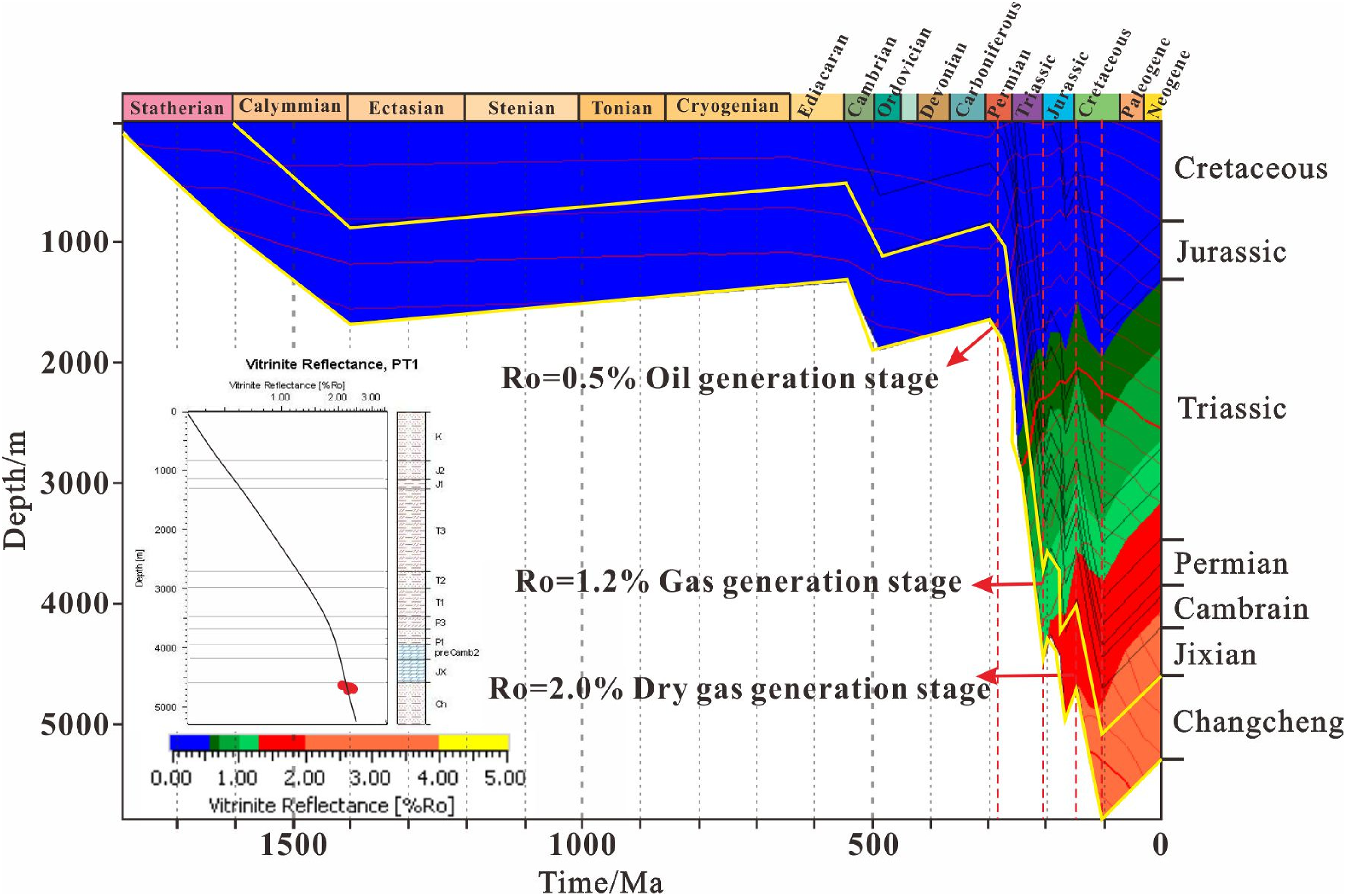
Burial and thermal evolution histories of formations in Well PT1.
The source rocks of the Cuizhuang Formation deposited with the breakup of the Columbia supercontinent, and in the sufficient space provided by the Proterozoic aulacogens in the Ordos Basin. The source rocks are distributed apparently under the control of the aulacogens, especially stable in the scope where there are large deep basement faults and Xiong’er volcanic formations. They show stable distribution mainly in the southern part of the Ordos Basin, and are relatable and traceable laterally. They extend from the Zhongtiao Mountains at the southeastern margin to the southern Tongchuan area, and enter the interior of the basin, suggesting a certain scale (Figure 14). Wells JIT1, HT14, XT1, and P1 in the southern part found the Cuizhuang Formation, totally 80–120 m thick, including dark mudstones of 10–30 m thick. Based on seismic facies, sedimentary facies, drilling data, and outcrops, the distribution of the mudstone was estimated (Figure 8). It is 166,700 km2, 70.9 m thick on average, and over 120 m at the most. The widespread and thick mudstone provides an abundant material basis for extensive hydrocarbon generation, making the Changchengian System an important successor for deep unconventional hydrocarbon in the Ordos Basin.
Cross-well section of dark mudstone of the Cuizhuang Formation in the southern Ordos Basin.
Conclusions
A typical three-part stratigraphic sequence is recognized in the Mesoproterozoic Changchengian System in the Ordos Basin. It comprises the basal Xiong’er Group (volcanic and volcaniclastic rocks), the middle Ruyang Group (clastic rock), and the upper Luoyu Group (fine clastic and carbonate rocks).
The volcanic rocks of the Xiong’er Group were encountered in the Ordos Basin for the first time. The Jinshan aulacogen is identified as a rift system. Zircon U–Pb ages of 1731 ± 27 and 1756 ± 19 Ma from the basalts provide direct evidence that the Ordos Basin responded to the break-up of the Columbia supercontinent. The stratigraphic distribution is controlled by the aulacogens.
Through comprehensive investigation of field outcrops, and drilling and seismic data, the tectonic-sedimentary pattern of the Changchengian System is confirmed as rifts followed by depressions, and the development scales of the aulacogens are determined. The rifting intensity decreased from southeast to northwest. The Xiong'er aulacogen at the southeastern margin is the earliest, and includes complete formations. The Jinshan aulacogen in the southern basin developed second, but lacks the Yunmengshan Formation of the Ruyang Group. The central Dingbian aulacogen is significantly smaller, exhibiting rift features only in the west, and the Luoyu Group is absent. The northern Helan aulacogen contains only the Beidajian Formation, lacks the Xiong’er Group, and forms a rifted trough.
The Proterozoic aulacogens developed with the breakup of the Columbia supercontinent provided sufficient accommodation space for source rocks of the Changchengian System. Dark mudstones in the Cuizhuang Formation yield TOC values as high as 1.58%. And the solid bitumen of the Cuizhuang Formation indicates that hydrocarbon migration and accumulation occurred during the geological history. It is concluded that there is a certain hydrocarbon exploration potential of the Proterozoic.
Footnotes
Author contributions
Xing Pan: writing–original draft, review and editing, investigation, and formal analysis. Gang Liu: experiment and data curation. Hai-feng Bai: visualization, investigation, and experiment. Lei Zhang: supervision and investigation. Jian-wu Zhang: investigation. Xiang-hui Jing: investigation. Jun-feng Ren: investigation. Xiao-qing Pan: graph drawing. All authors have read and agreed to the published version of the manuscript.
Funding
The authors disclosed receipt of the following financial support for the research, authorship, and/or publication of this article: This research was funded by the Major Science and Technology Projects of Changqing Oilfield Company (Grant Nos. 2024D1JC02, 2024D1JC06).
Declaration of conflicting interests
The authors declared no potential conflicts of interest with respect to the research, authorship, and/or publication of this article.