
Abstract
Deep exploration in complex fault-block regions is critical for global oil and gas development. As a representative region characterized by complex fault-block development, the northern part of the eastern Liaohe depression poses challenges in understanding the charging time and migration channels of deep hydrocarbons due to its intricate structural and reservoir conditions. For this purpose, this study utilizes diverse geological data from recent explorations, employing the petrological characteristics of inclusions, homogenization temperatures, and simulations of the thermal burial history to investigate the charging times of deep hydrocarbons. It combines the diagenetic processes of the reservoir with tectonic evolution to reveal the charging pathways and dynamic processes of deep hydrocarbons in the northern part of the eastern Liaohe depression. The results indicate that there are two charging periods in the study area: the late Oligocene (32.9–27.5 Ma) and from the late Neogene to the present (8.7–0 Ma). During these critical periods, faults with high activity intensity and low fault section normal stress were in an open state, which can serve as pathways for the vertical long-distance migration of hydrocarbons. In the first charging period, a substantial volume of hydrocarbon expelled from the source rocks migrates vertically into the deep sandstone reservoir through opening faults, exhibiting characteristics of source–reservoir separation. Subsequently, a brief uplift at the end of the Oligocene halted hydrocarbon generation. In the second charging period, as the source rocks further matured, a substantial volume of natural gas was injected into the deep reservoirs. At this period, the faults approached the seal, preventing hydrocarbons from migrating vertically and allowing them to enter the deep sandstone reservoirs adjacent to the source rocks, reflecting characteristics of source–reservoir proximity.
Introduction
As one of the essential types of petroliferous basins in the world, the faulted basin is characterized by a widespread distribution of terrestrial organic matter within it and has long been a hotspot for geological exploration (Beaubien et al., 2023; Sidik et al., 2024; Wang et al., 2024). The complex fault block oil fields will form when the interaction occurs between major faults in rifts, which have been identified across various oil-producing regions globally, such as oil and gas fields distributed in the North Sea, the Taranaki Basin in New Zealand (Kroeger et al., 2021), the Suez Gulf Rift (Tueckmantel et al., 2010), and the Bohai Bay Basin in China (Song et al., 2020). Research on some giant hydrocarbon reservoirs worldwide associated with faults have revealed several key characteristics: (a) hydrocarbon sources are varied and derived from multiple geological periods (Aya et al., 2024; Thomas et al., 2021; Wang et al., 2020); (b) Faults frequently act as significant barriers to hydrocarbon accumulation, while simultaneously functioning as conduits for fluid flow within fault-bounded traps (Jiang et al., 2019; Sperrevik et al., 2002; Zhang et al., 2006); (c) The significant heterogeneity of reservoirs in these regions results in a variable distribution of favorable hydrocarbon storage. (Mohammed 2022; Munir et al., 2023; Zeng et al., 2022). Consequently, the analysis of the intricate spatial-temporal arrangement among source rocks, reservoirs, and faults significantly advances the systematic study of the hydrocarbons migration process. Furthermore, in light of global climate change, carbon capture and storage (CCS) technology has increasingly emerged as a prominent research focus (Gibbins and Chalmers, 2008; Selma et al., 2014).Within this framework, the migration of carbon dioxide or underground fluids along fault and its injection into reservoirs are crucial for the effective implementation of CCS, groundwater management, and geothermal resource development (Bretan et al., 2020).Consequently, a comprehensive analysis of the injection data obtained during the hydrocarbon charging processes in complex fault blocks of oilfield exploration and development can provide substantial scientific support and recommendations for the formulation of future regulatory measures.
The research area is situated in the northern part of the eastern depression of the Liaohe Basin. Since 1964, the complex fault block oil fields of Niujü, Yushulin, and Chendanbao have been discovered, with a cumulative proven hydrocarbon reserve of 556 × 108 m3(Li et al., 2021; Wang et al., 2018). In recent years, industrial hydrocarbon has been successfully drilled from multiple sandstone formations at depths exceeding 3.5 km. Drilling results demonstrate that these deep hydrocarbon reservoirs are characterized by complex oil–water interfaces and significant variations in production. Published research on the northern part of the eastern depression of the Liaohe Basin remains limited. Existing studies primarily focus on structural evolution, sequence stratigraphy, sedimentary evolution, source rock evaluation, and the characterization of sandstone and volcanic rock reservoirs (Li et al., 2014a, 2014b; Li et al., 2020a, 2020b; Wei et al., 2015; Zhao et al., 2011a, 2011b). Numerous exploration examples suggest that the structural evolution of hydrocarbon-generating depressions influences the timing and migration patterns of hydrocarbon (Cui et al., 2022; Liu et al., 2023; Yang et al., 2021). The rift basin continues to subside under tensile action, which provides the foundational material for the formation of deeply buried tight sandstones and the thermodynamic conditions for kerogen evolution (Hao et al., 2011; Oguadinma et al., 2024; Sabouhi et al., 2024). The complex structural deformations formed during different stages of structural evolution, such as faults, unconformities, and uplifts, further control the distribution of sandstone reservoirs (Hany & Moustafa 2024; Zhang et al., 2018). However, the influence of these factors on the migration and accumulation of hydrocarbons in the deep, complex fault blocks is not yet well understood.
This study selected 73 typical sandstone samples with burial depths exceeding 3.5 km from the northern part of the eastern depression of Liaohe Basin for microscopic observation, microscopic fluorescent observation, and homogenization temperature analysis of fluid inclusions. By conducting 1D basin modeling on representative wells and combining the homogenization temperatures of fluid inclusions and diagenetic events, the timing of hydrocarbon charging was determined. Well logs and 3D seismic data were utilized to restore ancient structures, thereby assessing the influence of faults and sandstone bodies on hydrocarbon migration and accumulation during critical events. Additionally, we supplemented our analysis with δ13C data from natural gas within deep reservoirs, providing support for understanding the sources of deep hydrocarbons. It is hoped that the findings of this study will guide hydrocarbon exploration in complex fault blocks and offer valuable data support for related research in such areas. The findings of this study will guide hydrocarbon exploration in complex fault blocks and offer valuable data support for related research in such areas.
Geological settings
The eastern Liaohe depression is a narrow strip-shaped negative structural unit that extends in the NE direction, characterized by a gentle slope on the west side and a steep slope on the east side (Figure 1(b) and (c)). It is one of the five secondary structural units in the Liaohe Basin (Sun and Zhang, 2008). The study area is located in the northern part of the eastern Liaohe depression, which contains the largest hydrocarbon generation depression (Li et al., 2020a, 2020b). The southern part of the study area is close to the Qinglongtai structure, and the northern part is close to the Chendanbao structural belt. The western boundary and eastern boundary of the study area is the Cidong fault and Tongerpu fault, respectively (Figure 1(d)). From the Cenozoic to the present day, the study area has undergone three stages of evolution: arch-related extension, rifting and deformation. These three evolutionary stages can be further divided into five periods: the initial rifting stage of the Paleocene (Ef depositional period), the deep depression stage of the Eocene (Es3 depositional period), the spreading stage of the early Oligocene (Es1 and Es2 depositional period), the shrinking stage of the middle-late Oligocene (Ed depositional period), and the depression stage in the Miocene to the Quaternary (Ng, Nm and Q depositional period) (Sun and Zhang, 2008) (Figure 2). As the study area has experienced multiphase tectonic movements, two groups of NE–SW and E–W-trending faults have developed. Many grabens and horsts have formed from south to north, which have had important effects on the formation of traps and the transport of hydrocarbons (Figure 1(d)).
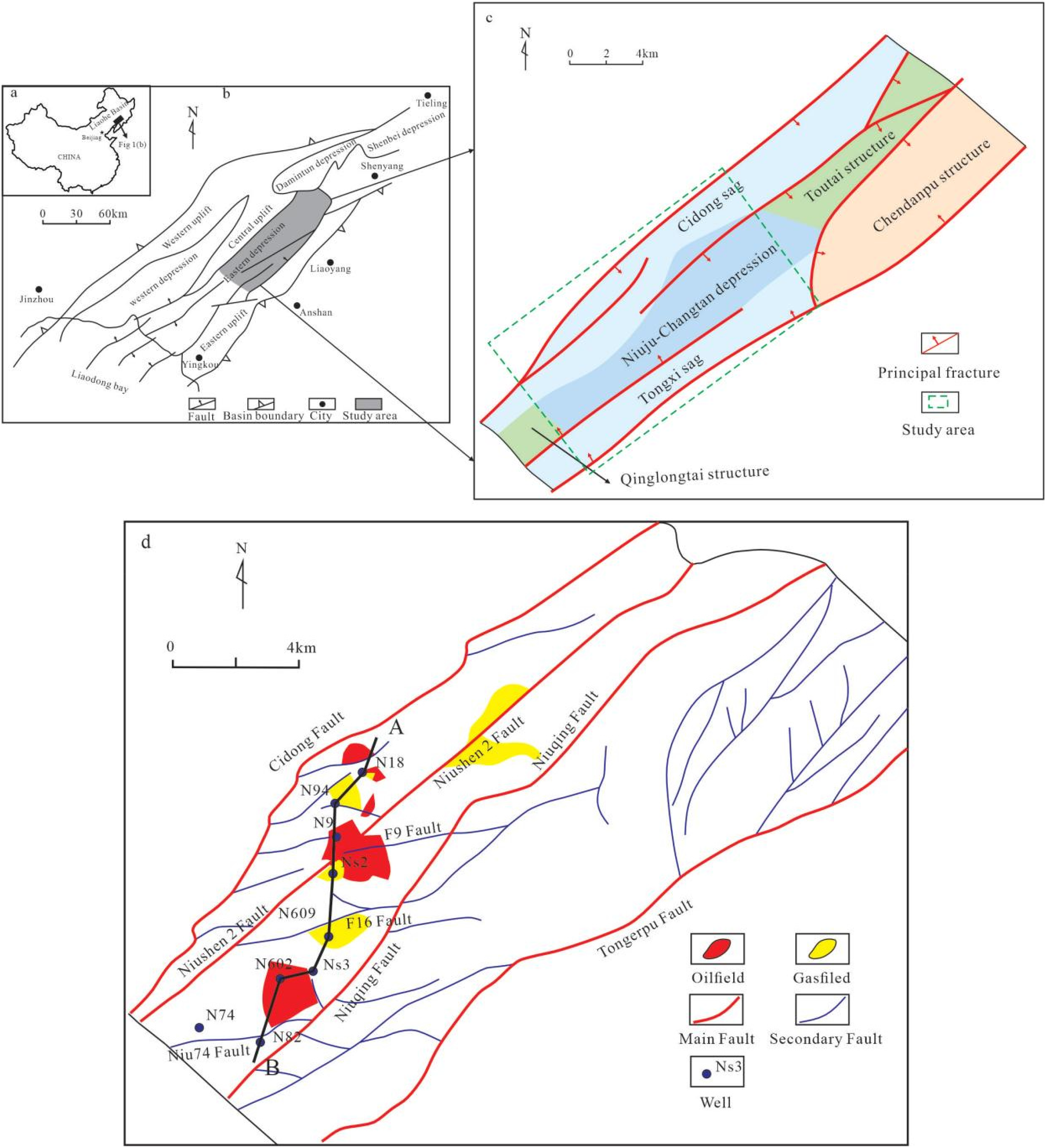
(a) Location of the Liaohe Basin in China. (b) Location of the eastern Liaohe depression; The gray band is the location of the northern part of the eastern Liaohe depression (modified from Zhao et al., 2011a, 2011b). (c) Distribution of sub-structure units in the northern part of the eastern Liaohe depression. The study area is marked by a green dashed box. (d) Locations of wells, faults, and oil–gas field in the study area.
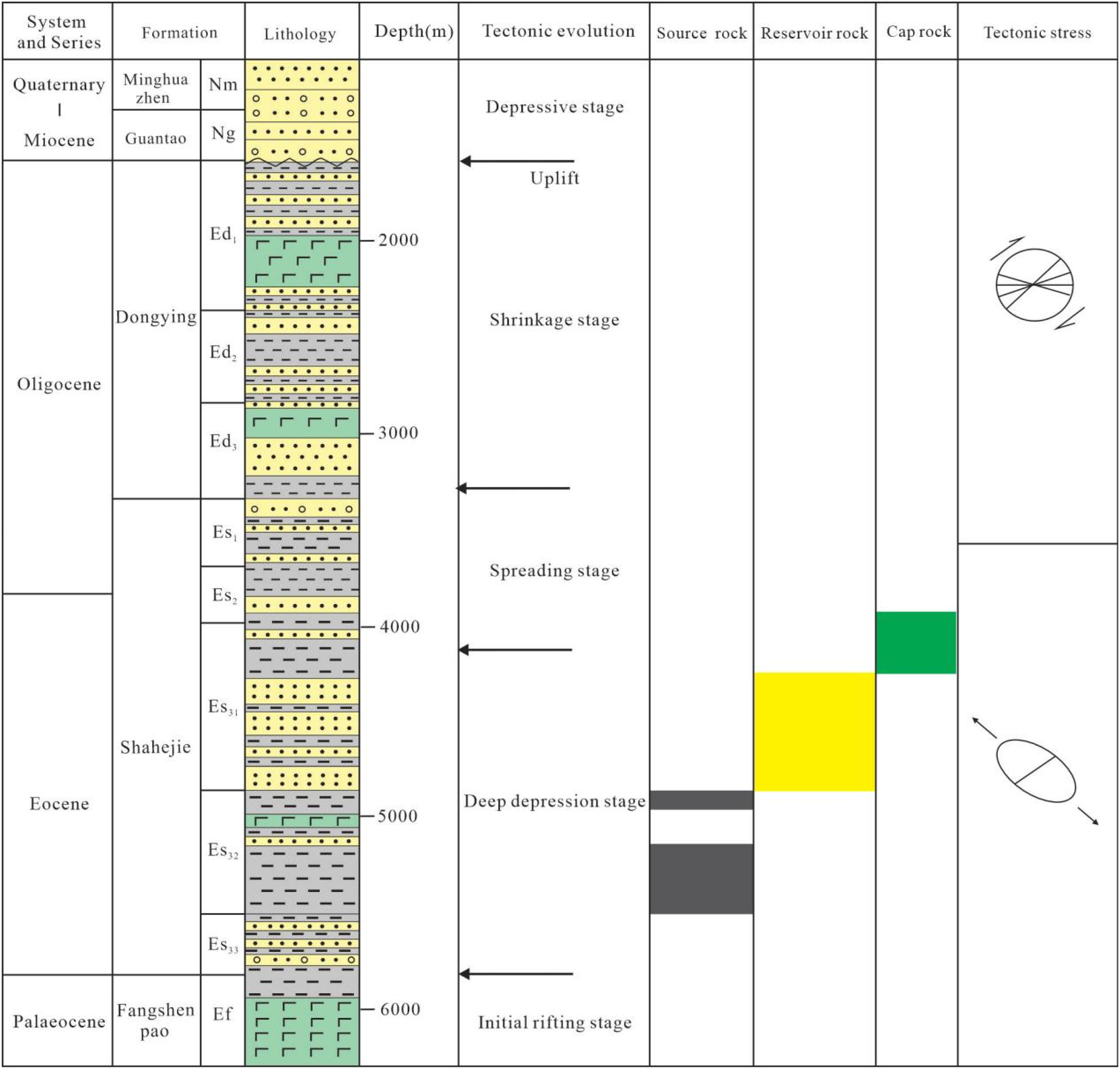
Stratigraphy, tectonic evolution, tectonic stress directions, and source–reservoir-cap assemblages in the northern part of the eastern Liaohe depression.
The strata developed within the eastern Liaohe depression include archeozoic metamorphic rocks, a crystalline basement composed of Cambrian clastic rocks and carbonates, Ordovician carbonates, Permian clastic rocks interbedded with coal strata, Mesozoic fine clastic rocks and volcanic rocks, early Paleocene volcanic rocks and carbonaceous mudstones, Paleocene terrestrial clastic rocks and Neogene–Quaternary alluvial deposits. Within the study region, the Paleocene Shahejie Formation section III (Es3) is composed mainly of deep lacustrine–semi-deep lacustrine and floodplain mudstones; the Shahejie Formation sections I and II (Es1, Es2) contain deltaic deposited conglomerates, sandstones and mudstones; the Dongying Formation (Ed) contains interbedded fluvially deposited sandstones and mudstones; and the Neogene Guantao Formation (Ng) and Minghuazhen Formation (Nm) contain fluvially deposited sandstones and conglomerates interbedded with thin mudstones (Liu et al., 2015) (Figure 2). A preliminary evaluation of the quality and distribution of hydrocarbon source rocks in the study area by previous researchers revealed that three sets of hydrocarbon source rock formations are present from bottom to top, namely, Es3, Es1, Ed (Figure 2). The high-quality hydrocarbon source rocks of the Es3 Formation are dark mudstones with a large single layer thickness and widespread distribution. These dark mudstones developed in deep and semi-deep lakes, with an average organic matter abundance of 2.64% and an organic matter type of mainly II2. When the burial depth of the source rocks in the middle member of the Shahejie Formation is greater than 4000 m, the Ro value is mainly distributed between 0.8 and 1.4%, which is in the mature to highly mature stage (Li et al., 2015; Wei et al., 2015). Therefore, the source rock of the third member of the Shahejie Formation is characterized by a deep burial depth, high abundance, good organic matter type and wide distribution area, which provides favorable conditions for forming deep natural gas. Previous studies on the study area have shown that the observed deep oil and gas mainly originated from this set of source rocks. At present, the discovered deep hydrocarbons (with a burial depth greater than 3500 m) is mainly distributed in the clastic sandstone reservoir in Es3, and the reservoir lithology is mainly lithic sandstone and feldspar lithic sandstone (Li et al., 2014a, 2014b) (Figure 2).
Materials and methods
Fluid inclusion analysis
Fluid inclusions serve as direct evidence for studying the processes of hydrocarbon accumulation, reflecting information such as fluid temperature, pressure, and composition during the accumulation process (Bodnar, 2003; Goldstein, 2001). A total of 74 lithologic samples were collected from the northern part of the eastern Liaohe depression. All rock samples are from the sandstone reservoir in the Es3 layer, and the burial depth is greater than 3500 m. Before observing fluid inclusions, the rock samples were double polished, and thin sections were made. Study of the spatial characteristics of mineral types and reservoir types were performed under Axioimager D1 m microscope transmitted light. The oil, gas and asphalt inclusions in the samples were observed under UV irradiation. Based on the above studies, samples with relatively high abundances of oil and gas inclusions were analyzed. After testing and calibration with standard samples, microscopic temperature measurements of water inclusions related to oil inclusions were carried out with a Linkam THM600 heating-freezing platform connected to an Axioimager D1 m fluorescence microscope (Zeiss). The homogenization temperatures were subsequently obtained via the thermal cycling test method.
To accurately determine the formation time of fluid inclusions, it is essential to establish and reconstruct both the burial and thermal histories in conjunction with the homogenization temperatures of fluid inclusions. This study employs data such as strata thickness, erosive thickness, geologic ages, lithology, and geothermal gradients to reconstruct the burial and thermal histories of a classic well using basin modeling techniques, thereby enhancing comprehension of the study area's geological history. These data, such as seismic data, geothermal gradients, and erosion thickness, were obtained from relevant geological reports provided by the Liaohe Oilfield of the CNPC.
Paleo-structure and paleo-fault displacement reconstruction
The paleo-structures of complex fault blocks that match at critical moments provide pathways and reservoirs for the migration and accumulation of deep hydrocarbon. Consequently, restoring the paleo-structure at these critical moments was essential for assessing the roles of faults and sandstone bodies in deep hydrocarbon generation, migration, and accumulation. This study establishes a correlation between seismic and well-log data to identify stratigraphic interfaces. Furthermore, 3D seismic data interpretation of the seismic data is performed to elucidate the characteristics of the faults in the study area.
To restore the paleo-structure at critical moments, it is vital to ascertain the paleo-burial depths and paleo-strata-thickness from those periods. The back-stripping method is employed to recover the paleo-burial depths and paleo-strata-thicknesses across various geological historical periods. This method relies on the sedimentation–compaction principle, wherein the present strata are incrementally stripped from the latest to the older based on each sedimentary period until reaching the target layer's sedimentation time. Ultimately, this approach provides the paleo-burial depths and paleo-strata-thicknesses for each layer during the target sedimentation period (Li et al., 2020a, 2020b). Building upon this, the tectonic evolution of the study area is effectively restored by application of a balanced cross-section technique to reconstruct the paleo-structure at critical moments. The current fault displacement generally results from cumulative tectonic evolution across multiple geological periods. Fault displacements associated with different sedimentary periods differ from the current fault displacement, necessitating the application of the largest displacement subtraction method to ascertain the paleo-fault displacements for each period (Fu et al., 2015). The principle of this method involves subtracting the largest fault displacement developed in the overlying strata from the current fault displacement of a specific fault within a given stratum, thereby obtaining the paleo-displacement for that sedimentary period (Figure 3).
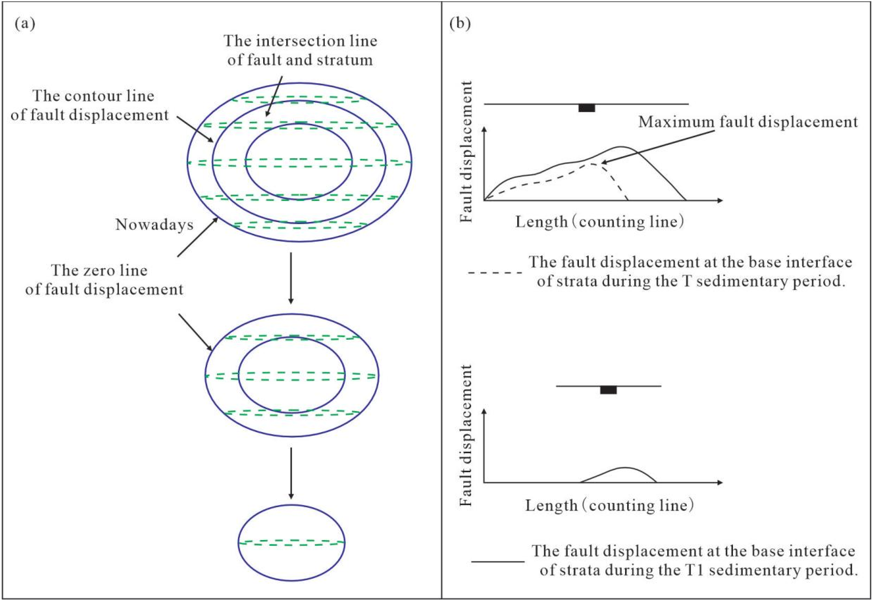
The largest displacement subtraction method. (a) Model for recovering the paleo-morphology of fault surface using the largest displacement subtraction method. Among them, the blue line represents the contour line of fault displacement, while the green line indicates The intersection line of fault and stratum. (b) Model for recovering the paleo fault displacement using the largest displacement subtraction method.
Results
Petrographic characteristics of fluid inclusions
The fluid inclusion method, as one of the most practical methods for studying the formation period of hydrocarbons, is capable of providing a wealth of geological fluid information. Fluorescence microscopy and petrographic observations were performed on reservoir samples from the Es3 formation (burial depth greater than 3500 m). The microscopy observations of thin sections under transmitted light and fluorescence indicate that oil-, gas- and water-bearing inclusions associated with hydrocarbon inclusions are present in the deep reservoir samples. The oil inclusions captured during the overgrowth of quartz are mainly in series or in groups (Figure 4(e)). There are numerous oil inclusions inside the quartz grains and cracks in the quartz grains, and the inclusions are mainly in series or sporadically distributed (Figure 4(d) and (f)). In contrast, the oil inclusions captured in the feldspar particles are mainly sporadic or distributed in groups (Figure 4(c)). The gas inclusions appear as gray bubbles in single polarized light and are distributed in fractures within the quartz, in bunches on the surface of the quartz (Figure 4(a)), or in groups with the oil inclusions (Figure 4(b) and (g)). Yellow oil impregnation can be observed between mineral particles and dissolved pores (Figure 4(h)).
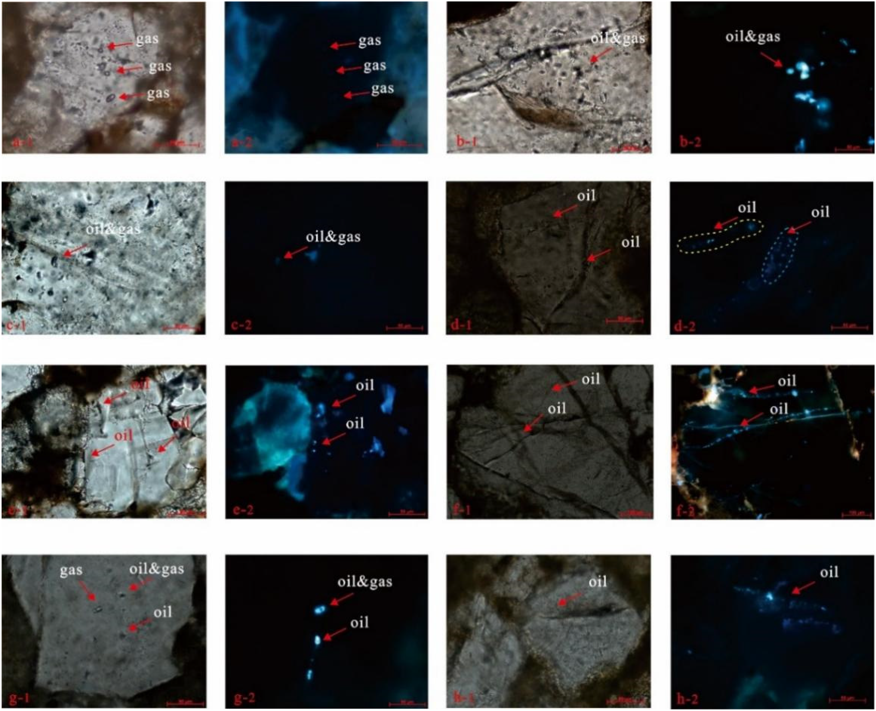
Micrographs showing inclusions in the Es3 reservoir of the Niuju-Changtan depression. (a-1) Gas inclusions distributed on the surface of the quartz grains in the Ns2 well at 3846.4 m, (b-2) Bright yellow‒green edges of the inclusions visible in the Ns2 well at 3846.4 m, (b-1) gas‒liquid inclusions clustered in quartz in the Ns2 well at 4147.35 m, (b-2) the fluorescence color of the inclusion is blue‒white in the Ns2 well at 4147.35 m, (c-1) the fluorescence color of the inclusion is blue‒white in the Ns2 well at 4444.81 m, (c-2) the fluorescence color of the liquid part in the inclusion is blue in the NS2 well at 4444.81 m, (d-1) inclusions are beaded along fractures in the N94 well at 3911.28 m, (d-2) inclusions have blue‒white fluorescent colors in the N94 well at 3911.28 m, (e-1) inclusions are distributed in the edge cracks of quartz particles in the N94 well at 4101.2 m, (e-2) the fluorescence color of the inclusion is blue in the N94 well at 4101.2 m, (f-1) inclusions distributed in cracks through quartz grains in the N94 well at 4124.2 m, (f-2) the fluorescence color of the inclusion is blue in the N94 well at 4124.2 m, (g-1) inclusions are beaded within quartz particles in the Ns3 well at 3683.3 m, (g-2) the liquid part of the inclusion is bright blue and white in the Ns3 well at 3683.3 m, (h-1) inclusions distributed in the fractures in quartz grains in the Ns3 well at 3911.28 m, (h-2) the fluorescence color of the oil inclusion is blue in the Ns3 well at 3911.28 m (column 1 shows single-polarization photographs, and column 2 shows ultraviolet fluorescence photographs for the same target).
There are two fluorescent colors of the oil inclusions in the samples in this study: blue and bright blue‒white (Figure 4). These two fluorescent colors are found within inclusions in both feldspar and quartz grains. The oil inclusions within early micro-fractures are blue in color, and the inclusions within late fractures are blue‒white in color (Figure 4(d)). Moreover, the color of the oil inclusions and oil—gas inclusions associated with natural gas inclusions are generally blue‒white (Figure 4(g)), and this type of inclusion has high transparency under single-polarized light.
Homogenization temperatures
On the basis of the petrographic characteristics of the inclusions, homogenization temperature measurements were carried out on 73 oil and gas inclusions in the Es3 formation. The homogenization temperatures of the hydrocarbon inclusions range from 115 °C to 170 °C, and the temperatures can be divided into two ranges (Figure 5). The types of inclusions in the first temperature range are oil inclusions and oil–gas inclusions. These inclusions have blue or blue‒white fluorescence colors, and the oil and gas inclusions have uniform temperatures of 120 °C to 140 °C, with a peak occurring between 125 °C and 135 °C. The inclusions in the second temperature range are dominated by oil—gas inclusions and gas inclusions, and the fluorescence colors of these inclusions are blue. The gas inclusions have uniform temperatures of 145 °C to 170 °C, with most of the measurement points concentrated between 150 °C and 155 °C.
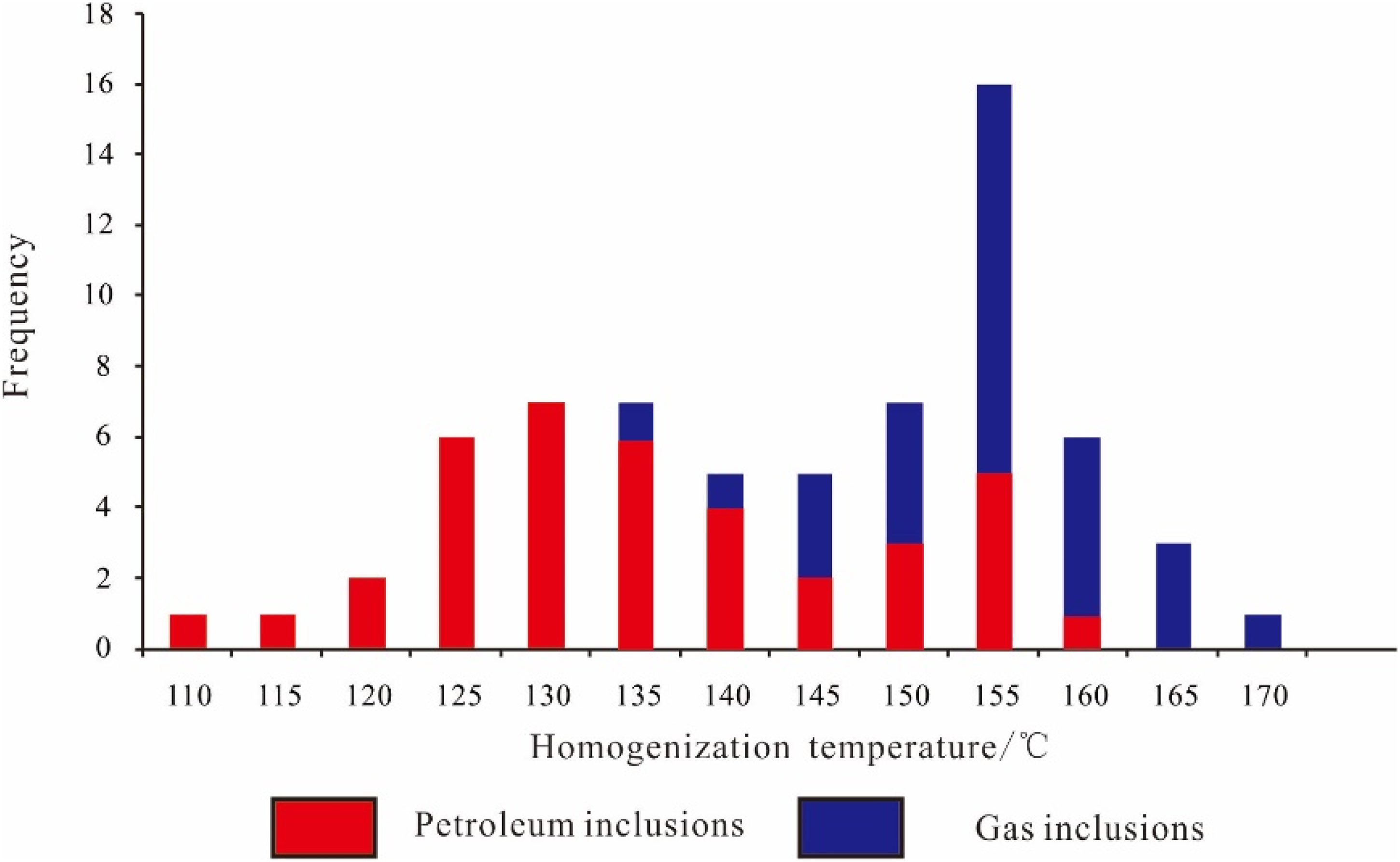
Histograms of homogenization temperature (Th) of coeval brine inclusions in the Es3 formation.
Diagenesis of minerals in deep sandstone reservoir
The diagenetic minerals in the Es3 formation reservoir in the study area include quartz, feldspar, calcite and clay minerals. Diagenesis mainly included compaction, cementation and dissolution. The reservoir in the third member of the Shahejie Formation is buried at great depth and has experienced long-term compaction, with closely packed mineral particles and gradually reduced pore space. Observations of thin sections show that compaction is manifested by long linear‒convex contacts between debris particles. Suture line contacts have formed between quartz particles by compaction dissolution (Figure 6(a)), and plastic particles such as mica and mudstone clasts have been bent and deformed by compression (Figure 6(b) and (c)). Cementation in the study area is relatively common, and the commonly observed cementation minerals are carbonate minerals, siliceous minerals and clay minerals. Calcite cements are most common in carbonate rocks, and two phases of calcite cements can be observed in the samples (Figure 6(d) and (e)). The early carbonate cements are dominated by base-type calcites, which have orange-yellow cathodoluminescence characteristics. The late carbonate cements are mainly dolomite and mostly appear in reservoirs that did not experience strong early calcite cementation (Lai et al., 2018). Siliceous cementation in the deep reservoirs in the study area is mainly in the form of secondary quartz enlargement and authigenic columnar quartz, with inclusions usually captured in areas of secondary quartz enlargement. The unstable components such as feldspar and lithic materials in the reservoir are strongly corroded, forming many secondary dissolved pores (Figure 6(h) and (i)). Under the microscope, kaolinite, mixed-layer illite and late dolomite can be observed filling these dissolution holes. In addition, asphalt fills the gaps between particles and the dissolved pores (Figure 6(j) and (k)).
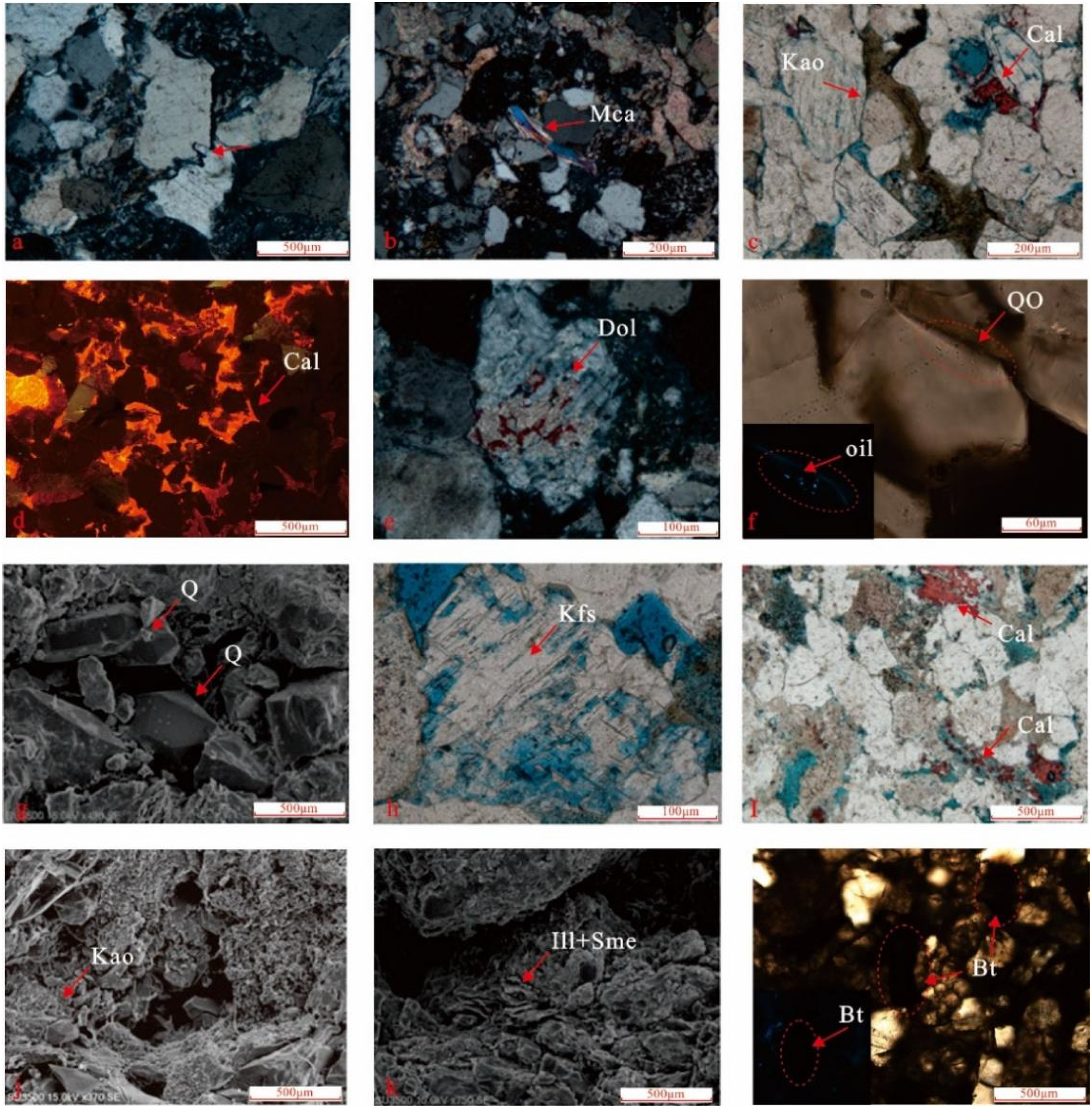
Photomicrographs showing the types and textures of minerals and bitumen under transmitted light, scanning electron microscopy and cathodoluminescent light. Single-polarization photographs of diagenetic minerals: (a) a suture contact between quartz particles in the Ns2 well at 3680.5 m; (b) deformation of muscovite particles in the Ns2 well at 3848.4 m; (c) early calcite (orange under cathodoluminescence) in the NS2 well at 3848.4 m; (e) late dolomite filling dissolved feldspar pores in the N94 well at 3680.5 m; (f) oil inclusions trapped in secondary quartz enlargement in the N94 well at 3659.72 m; (g) scanning electron microscope images of authigenic quartz filling a mold pore in the NS2 well at 4100.69 m; (h) dissolved pores in feldspar grains in the Ns2 well at 3661.88 m; (i) cements between mineral particles are corroded in the N94 well at 3910 m; scanning electron microscope images of clay minerals; (j) kaolinite minerals filling intragranular dissolved pores in the Ns2 well at 3694.9 m; (k) mixed-layer illite filling pores in the N94 well at 3913 m; (l) asphalt filling the gap between mineral particles in the Ns2 well at 3846.9 m.
Discussion
Sources of the deep hydrocarbons
The study area contains the largest hydrocarbon depression in the northern part of the eastern Liaohe Depression, with deep hydrocarbon sources originating from the source rocks within the depression (Li et al., 2015). The main kerogen type of hydrocarbon source rocks within the study area is mainly II2 and III, and this type of hydrocarbon source rock is thought to be primarily gas-producing (Gannon and Henstridge, 1987; Zhou et al., 2011). Based on the vitrinite reflectance, when the burial depth of source rocks ranges from 2400 to 4500 m, the Ro value is between 0.5 and 1.3, indicating that the source rocks are in a mature stage. When the burial depth of the source rocks exceeds 4500 m, the Ro value is greater than 1.3, indicating that the evolution of the source rocks is in a high maturity stage (Figure 7).
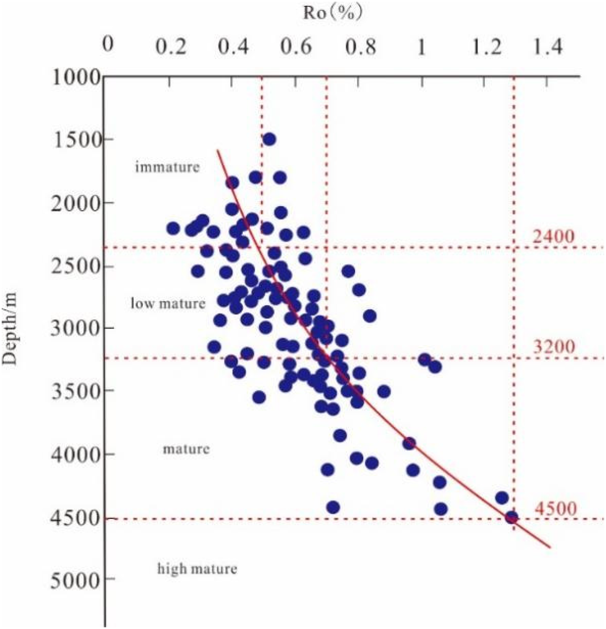
Organic matter maturity evaluation diagram of the source rocks in the Es3 formation in the northern part of the eastern Liaohe Depression (modified from Yu, 2015).
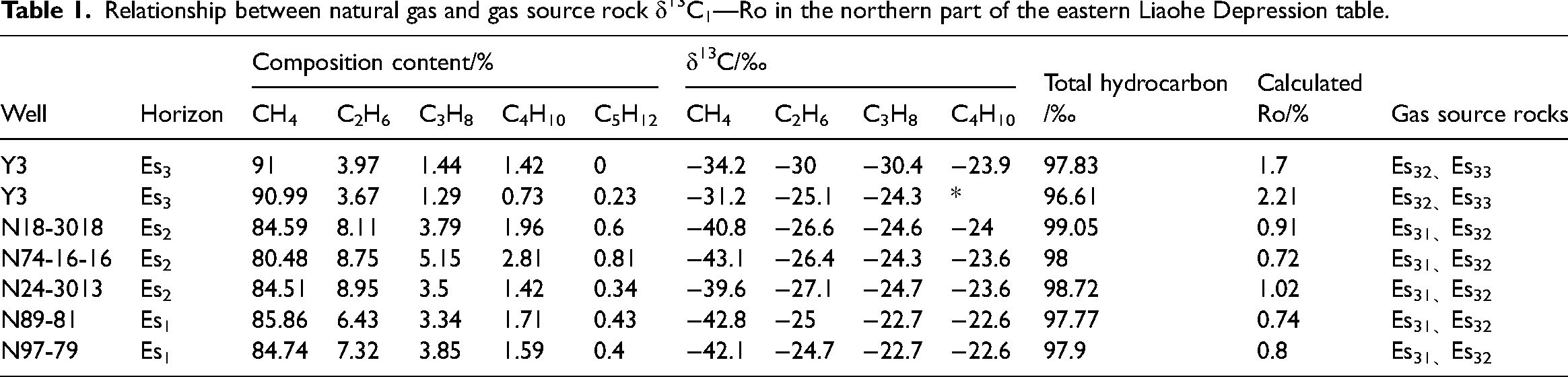
Fluid inclusion samples from deeply buried reservoirs in the study area exhibit oil inclusions and oil–gas inclusions, which show blue and blue-white fluorescence. In contrast, fluid inclusions from shallower depths display blue fluorescence (Figure 4). The homogenization temperatures of the fluid inclusions indicate differing formation times for shallow oil inclusions and deep gas inclusions. Early studies have also provided geological conditions supporting the sources of oil and gas. These early investigations primarily focused on shallow hydrocarbons in the upper reservoirs of the Ed, Es1, and Es2 formation (Liang et al., 2014; Zeng et al., 2002), with these hydrocarbons being at low to moderate maturity stages. The oil-source correlation reveals a genetic relationship between hydrocarbon found at depths greater than 3250 m and source rocks located below 3500 m, with hydrocarbon at structural high parts, exhibiting lower maturity than those at lower positions (Chen and Wu, 2003; Wang, 2008). This observation aligns with the findings from fluid inclusion samples. This study also includes additional methane samples from the Es3 formation, where methane carbon isotopic can be utilized to assess the thermal evolution degree of natural gas. According to previous research, δ13C1 values less than −55.00‰ are classified as biogenic gas, values between −55.00‰ and −48.00‰ as bio-thermocatalytic transitional zone gas, values between −48.00‰ and −35.00‰ as pyrolysis-gas, and values greater than −35.00‰ as cracked gas (Pei et al., 2023). In the central-southern part of the study area, natural gas δ13C1 values range from −48.00‰ to −35.00‰, indicating accumulation in the pyrolysis–gas zone. Conversely, the natural gas samples from well Y3 in the northern area all have δ13C1 values greater than −35.00‰, categorizing them as cracked gas (Table 1). Based on the aforementioned studies, the deep hydrocarbons in the study area originate from the dark mudstones in the middle to lower sections of the Es3 formation and exhibit multiple phases of generation.
Relationship between natural gas and gas source rock δ13C1—Ro in the northern part of the eastern Liaohe Depression table.
Timing of hydrocarbon charge
The homogenization temperature range of contemporaneous brine inclusions associated with oil and gas inclusions in a single-well burial history map allows the timing of gas infill in the study area to be determined (Yang et al., 2021). The key parameters of the eastern Liaohe depression used in this simulation were determined via information provided by the Liaohe Oilfield of the CNPC. The application of basin simulation technology to restore the burial history of the study area indicates that from the sedimentary stage of the Ef depositional period to the Ed depositional period (43–27.5 Ma), the study area experienced varying degrees of subsidence. During the late Ed depositional period, regional tectonic uplift occurred in the study area, with the depression again experiencing subsidence starting at 24.5 Ma and continuing to the present day (Figure 8).
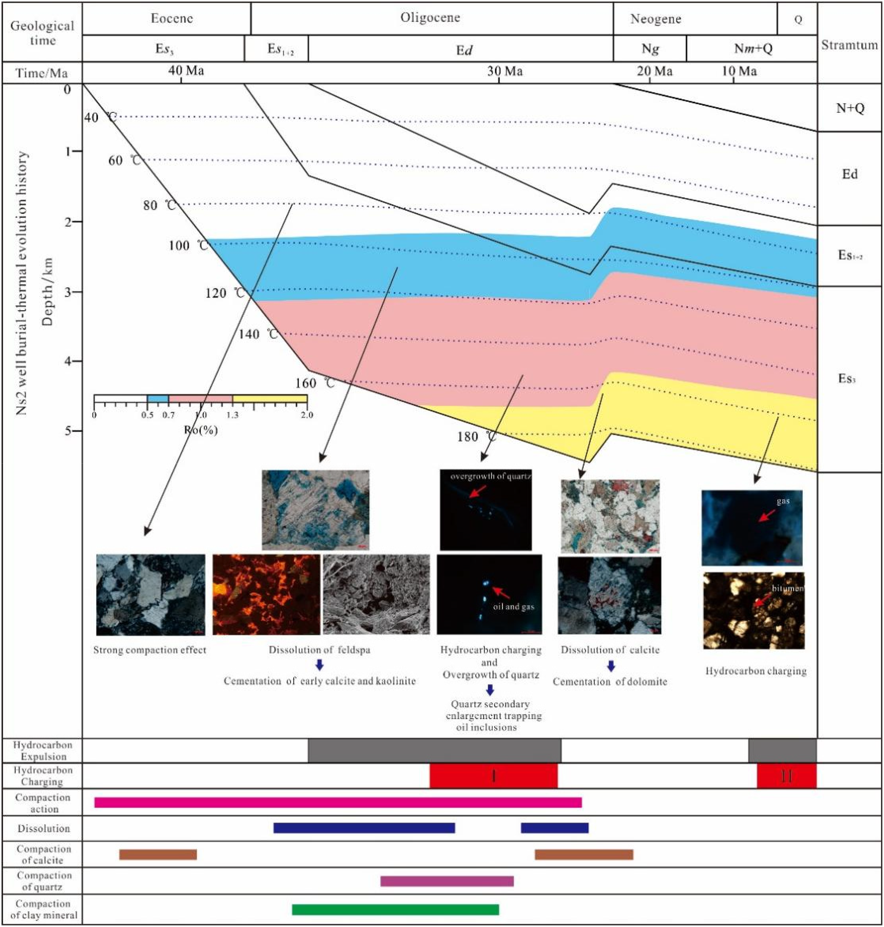
The burial–thermal history in well Ns2.There is a strong correlation between the measured temperatures of fluid inclusions, diagenetic events, and simulation results.
The maturity of source rocks increases with burial depth, and this process is irreversible. However, hydrocarbon generation can be interrupted by tectonic uplift and other factors, after which the source rocks may resume hydrocarbon generation at greater depths (Yang et al., 2017). The timing of primary hydrocarbon generation from source rocks determines the earliest time of formation of hydrocarbon reservoirs (Zhao et al., 2021). Taking the inclusion samples of the Es3 formation in the Ns2 well as an example, the homogenization temperature combined with the burial thermal evolution history of the reservoir was used to determine the accumulation time of depth hydrocarbons. The fluid inclusions in the 3864 and 4147.35 m sandstone samples are dominantly oil inclusions and gas‒liquid inclusions, and brine inclusions associated with oil inclusions are found in the early quartz dissolution joints and quartz enlargements. These inclusions exhibit uniform temperatures between 120 °C and 135 °C. Combined with the thermal evolution history of the reservoir, the formation time is determined to be 32.9–30.8 Ma, corresponding to the Ed depositional period. The middle-term period corresponds to the early stage of reservoir formation in the first phase of the depression, when hydrocarbons filling was dominant. The fluorescence within the gas‒liquid inclusions is generally blue, and associated brine inclusions are found within quartz rims. These fluid inclusions have homogenization temperatures between 140 °C and 150 °C. The formation occurred between 30.8 and 27.5 Ma, corresponding to the late stage of the first phase of development, during which natural gas infusion was present. The inclusions in the 4444.81 m rock chip feldspathic sandstone sample are mainly gas inclusions, and the inclusions in the 4444.81 m feldspathic sandstone sample are predominantly gas inclusions distributed along the edges of quartz grains and within quartz fractures (Figure 8). The gas inclusions are accompanied by brine inclusions with a uniform temperature distribution in the range of 145–155 °C. On the basis of the reservoir burial–thermal history map, the formation time was determined to be between 8.7 Ma and the present day, corresponding to the late deposition of the Ed depositional period to the present day, during which large amounts of high-maturity hydrocarbons and high proportions of natural gas were injected.
Deep reservoir conditions
From the beginning of the Es3 depositional period in the study area, the depression continuously subsided under regional stress. This subsidence has resulted in deepening water bodies and an ample supply of clastic material deposited in the northern part of the eastern Liaohe Depression subsidence center. The Es3 formation features braided river delta deposits on the east and west sides of the depression, with a small development area and no overlap (Fan et al., 2009; Hui et al., 2003; Liu et al., 2015). Exploring deep hydrocarbons is mainly found in the sandstone reservoir of the braided river delta plain subfacies and the braided river delta front subfacies.
The sandstone reservoirs in the Es3 formation are composed of lithic sandstone and feldspathic–lithic sandstone. The deep sandstone reservoir is in a buried diagenetic state during the Es3 depositional period, undergoing compaction and cementation, which leads to a reduction in primary porosity. During the middle–late Ed depositional period, secondary pores developed due to hydrocarbon charging of the reservoir, which created an acidic environment. During the same period, the faults in the depression were active, and the faults formed structural fractures in the sandstone layer, which further improved the physical properties and connectivity of the sandstone layer (Fan et al., 2009). Simultaneously, the study area experiences tectonic activity, which results in the formation of structural fractures within the sandstone reservoirs, thereby enhancing the physical properties and connectivity of the sandstone. The sandstone at the Es31 formation in thickness from 100 to 400 m, with a sandstone / mudstone ratio between 35% and 65%, and contains sandstone–mudstone interbed formation (Figure 9(A)). The thickness of the sandstone bodies thins toward the edge of the study area, but the sandstone / mudstone ratio and the physical properties of the sandstone bodies improve. The sandstone at the Es31 formation porosity is between 8% and 15%, and the permeability is greater than 1 × 10⁻³ μm2 (Figure 10(A-1) and (A-2)). The sandstone reservoir in the Es32 formation located on the eastern and western sides of the study area has a thickness from 50 to 250 m and a sandstone / mudstone ratio of 35% to 55%. The sandstone at the Es32 formation porosity is between 4% and 12%, and the permeability is of 0.1 to 1 × 10⁻³ μm2 (Figure 10(B-1) and (B-2)). Therefore, the deep sandstone in the study area provides migration channels and ample reservoirs for deep hydrocarbons.
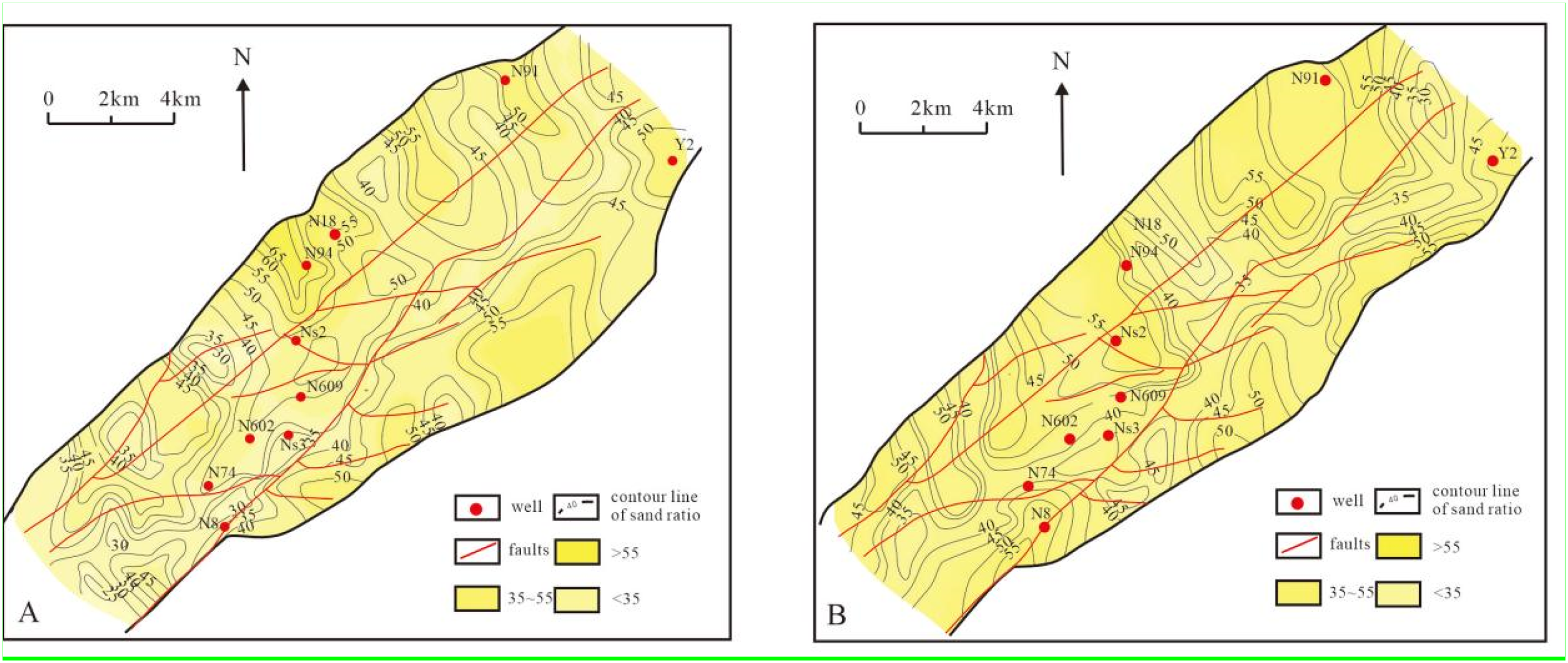
Sandstone / mudstone ratio of the deep sandstone reservoirs in the Es3 formation. (A) is the Es31 formation and (B) is the Es32 formation.
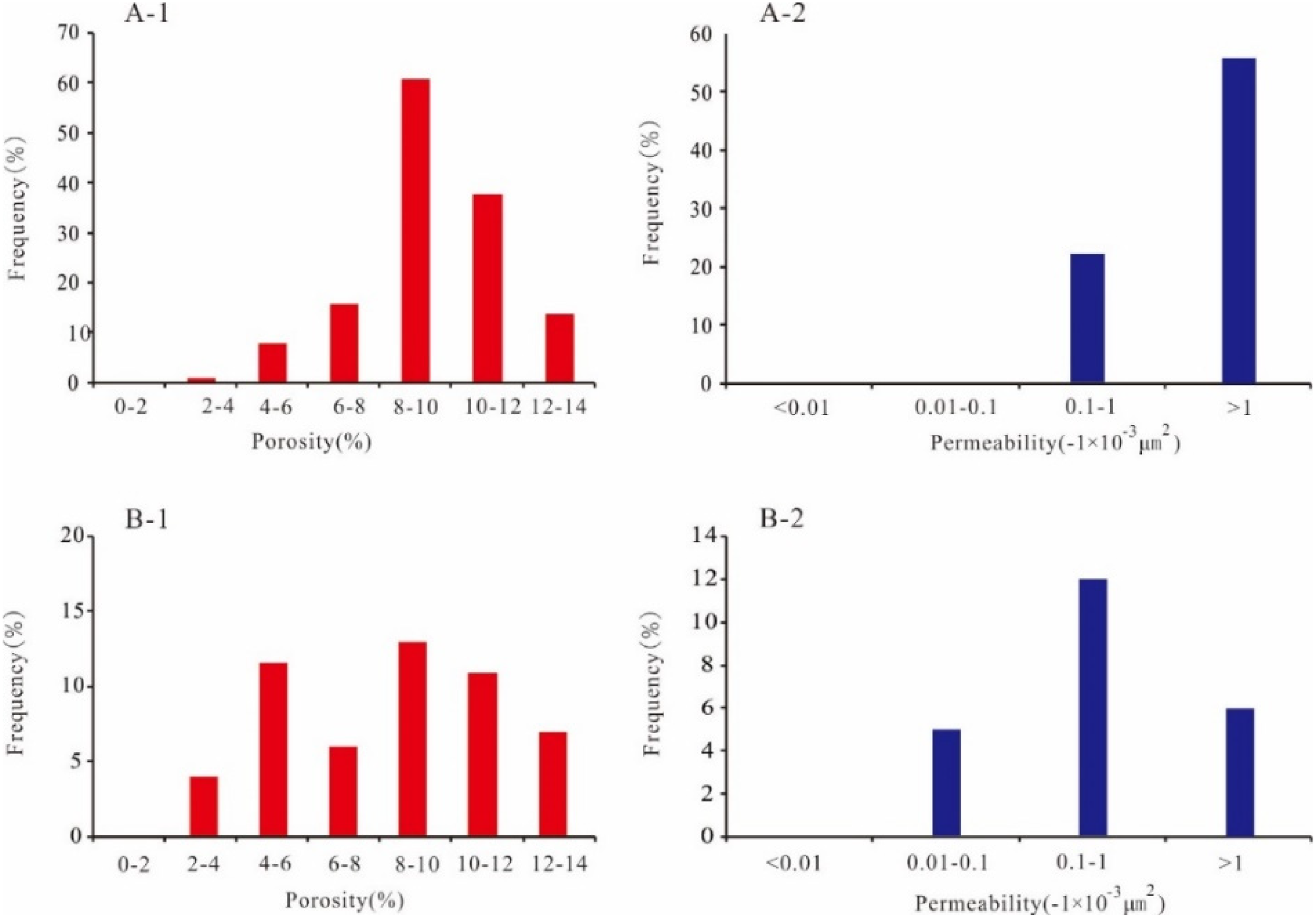
Physical property statistics of the deep sandstone reservoirs in the Es3 formation. (A-1) is the porosity of the Es31 formation sandstone reservoir; (A-2) is the permeability of the Es31 formation sandstone reservoir;(B-1) is the porosity of the Es32 formation sandstone reservoir;(B-2) is the permeability of the Es32 formation sandstone reservoir.
Evaluation of migration faults at critical moments
The lower source rocks of the Es3 formation in the northern part of the eastern Liaohe depression, along with the upper reservoirs of the Es3 formation, constitute a “lower generation and upper storage” reservoir combination. Faults are important links between hydrocarbon source rocks and reservoirs and are the main pathways of deep hydrocarbons migration and accumulation in the study area. The opening and closing of faults during different tectonic evolution are critical factor in the migration and accumulation of deep hydrocarbons. Four major faults, the Cidong fault, the Tong Erpu fault, the NiuShen 2 fault and the Niu Qing fault, and a series of northeast-oriented secondary faults are observed in the study area (Li et al., 2020a, 2020b; Liu et al., 2002) (Figures 1 and 11). Existing research results indicate that faults can be classified into two types based on fault properties: growth faults in the deep strata and strike-slip faults in the shallow strata. The growth faults in the deep strata serve as the primary migration channels for deep hydrocarbons (Ji and Han, 2008; Zhang et al., 2005). Faults that connect hydrocarbon source rocks and reservoirs, that are active during the hydrocarbon generation and that play a role in the hydrocarbons migration are commonly referred to as oil source faults (Fu and Wang, 2018; Hindle et al., 1997). The Niushen 2 fault, Niuqing fault, F9 fault and Niu 74 fault in the southern center of the study area connect the source rock in the lower part of the Es3 formation and the sandstone reservoir in the upper part of the Es3 formation and provided channels for hydrocarbons charging (Figures 1 and 11).
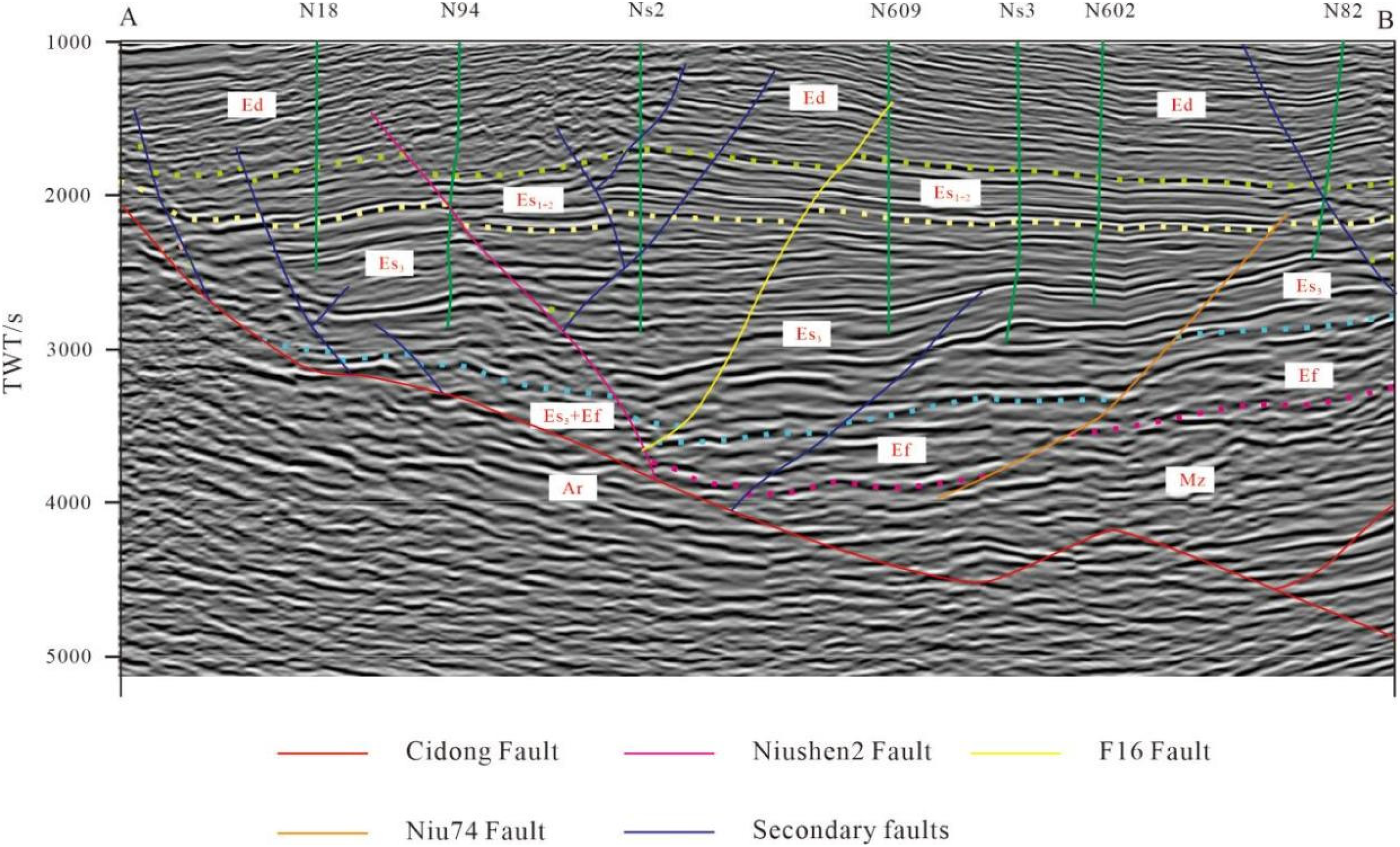
NW-trending seismic section AB and its interpretation.
To date, deep hydrocarbon accumulation in the vertical direction near these faults is predominantly observed in the upper and middle sections of the Es3 formation (Figure 2). However, not all locations on the plane where traps are developed exhibit hydrocarbon accumulation. Therefore, it is essential to identify oil source faults by evaluating their migration capacity during the hydrocarbon charging period, specifically considering the degree of development and the state of opening of the faults during this period (Wang et al., 2015). This study focuses on the rate of fault activity to quantify the intensity of fault activity. The faults characteristic of the study area were studied through numerous geological profiles. The calculation results indicate that fault activity was relatively high during the Shahejie formation depositional period. However, the activity rate decreased during the first stage of hydrocarbon charging and nearly ceased in the second stage (Figure 12). During the Ed depositional period, when hydrocarbon charging occurred, the fault activity of the Niushen2 fault exhibited the highest velocity among all faults, reaching 17 m/Myr. The fault activity velocity of the Niuqing fault was the second highest, reaching 14 m/Myr. The activity velocity of the F9 fault is significantly lower than those of the Niushen 2 fault and Niuqing fault, and the maximum activity rate was 6 m/Ma.
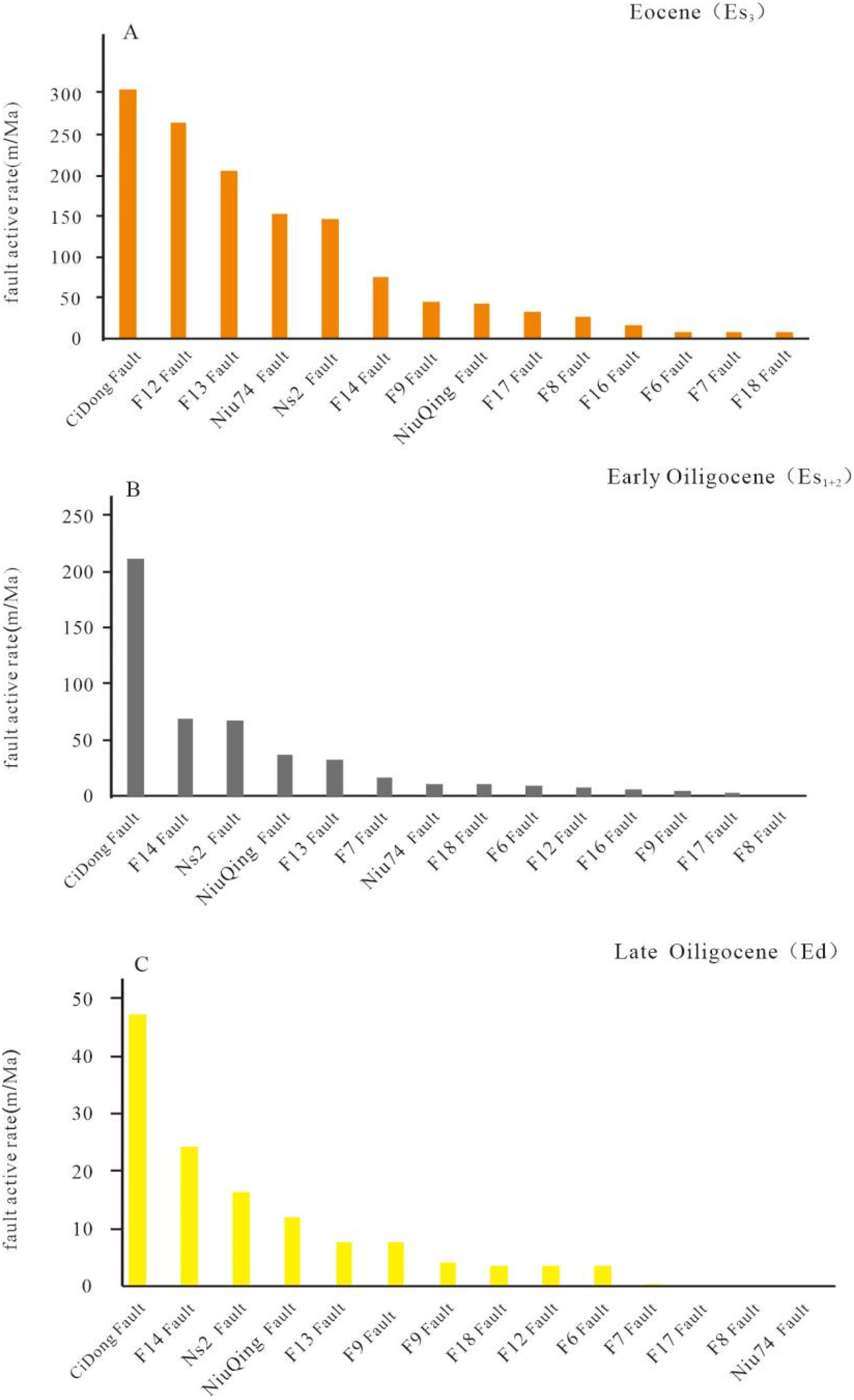
The activity rates of faults in the northern part of the eastern Liaohe depression.
Hydrocarbon migration in the fault conduit system primarily occurs along the direction of the faults, while the opening and sealing of these faults significantly influence hydrocarbon migration and accumulation. The degree of opening of the deep hydrocarbon migration channels of oil source faults was affected by the fault section normal stress. The lower the dip angle, the greater the fault section normal stress; conversely, this also corresponds to a reduced degree of openness of the dominant hydrocarbon migration channels (Fu et al., 1998; Jaeger and Cook, 1979). Based on previous findings, the paleo-burial depth and paleo-inclination parameters for each sedimentary period were derived from the reconstruction of the tectonic evolution history. Additionally, the magnitude and direction of horizontal stress during each sedimentary period were acquired from the history of the tectonic stress field (Li et al., 2020a, 2020b; Tian et al., 2003). The paleo-density of the rock at the fault surface is referenced against the current density value range, ultimately leading to the calculation of the fault section normal stress for each period. the paleo fault section normal stress on the Niuqing fault ranged from 3 to 20 MPa in the Es32 formation and the Es33 formation. During the Ed depositional period, the stress on the Ed formation varied between 34 and 44.19 MPa. For the Niushen 2 fault, the paleo-stress was low, ranging from 2.35 to 37.72 MPa, which is below the plastic deformation limit for fault mudstone. In the Niu 74 fault and the F9 fault, the stress during the Ed depositional period to the present day ranged from 24 to 37.4 MPa (Table 2). Overall, the paleo-stress on all four faults increased over time, with levels rising from the Ed depositional period to the present, and the paleo-stress on the Niushen 2 fault being the lowest, establishing it as the main oil source fault (Figure 12).
Reconstructed paleostress results for the Niushen2 Fault, NiuQing Fault, F9 Fault, and F74 Fault.
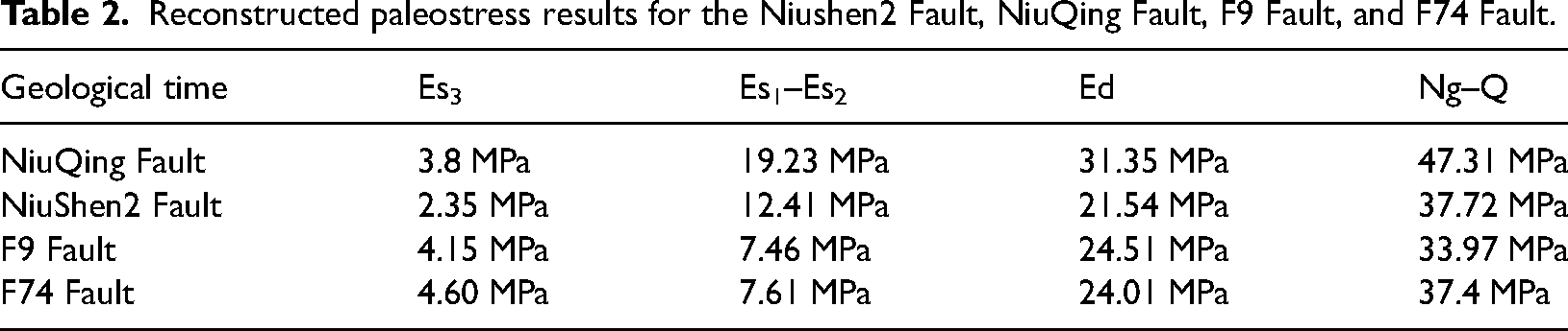
Fault activity reflects the period and intensity of fault movement, while the paleo fault section normal stress indicates the degree of fault sealing. The combination of these two factors can reflect the evolution history of fault opening and sealing. The Niushen 2 fault, the Niuqing fault, the Niu 74 fault and the F9 fault are the four main oil source faults in the study area, and the well areas with relatively good deep hydrocarbon reservoirs are adjacent to these four faults. The F9 fault opened only during the Es3 depositional period, closed during the Es1 depositional period and the Ed depositional period, and remained closed during the reservoir formation period (Figure 13(A)). The Niuqing fault and the Niu 74 fault were in an open state from the Es3 depositional period to the early Ed depositional period and they have remained in a closed state from the late Ed depositional period to the present (Figure 13(B) and (C)). The Niushen 2 fault was opened from the Es3 depositional period to the Ed depositional period and has been closed since the uplift stage of the Ed depositional period (Figure 13(D)).
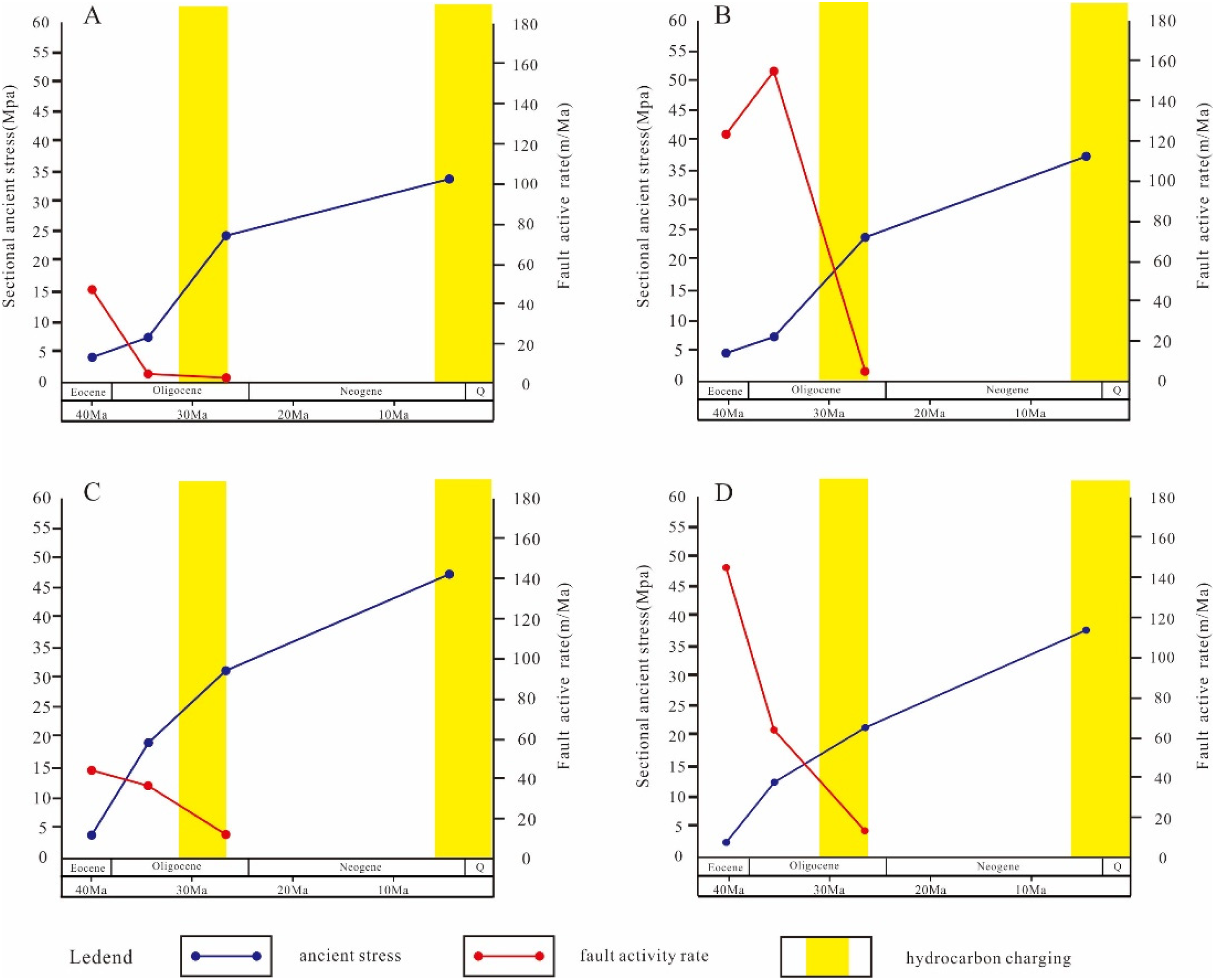
Fault opening and closing in different stages of tectonic evolution. (A represents the F9 Fault, B represents the Niu74 Fault, C represents the NiuQing Fault and D represents the NiuShen 2 Fault.).
Hydrocarbon charging process and accumulation mode
From the Paleocene to the Quaternary, the northern part of the eastern Liaohe Depression transitioned from an extensional regional stress field to a tension-torsion and strike-slip regional stress field, establishing a foundation for deep hydrocarbon reservoirs. The relationship between tectonic evolution and hydrocarbon generation from source rocks resulted in two distinct stages of reservoir formation during the Es3 depositional period.
The Eocene marked the primary development period of the extensional tectonic system in the eastern depression of the Liaohe Basin. The study area was influenced by the Tongerpu Fault and the Cixi Fault, characterized by a deep lacustrine and semi-deep lacustrine depositional environment. Fault extension has resulted in the formation of complex fault block traps in the study area, which largely developed at the end of the Es3 depositional period and are conducive to deep hydrocarbon charging. Uplift occurred in parts of the depression during the late stage of the Es3 depositional period, followed by ongoing subsidence in the northern part of the eastern Liaohe Depression. The hydrocarbon source rocks in the Es32 formation and the Es32 formation reached Ro values of 0.5%–0.7% in the early to middle Oligocene (during the Es1 and Es2 depositional period) and entered the low-maturity to mature period when hydrocarbon generation began. The Es1 and Es2 depositional period was a transitional stage from the induced extension period to the tension-torsion period. The faults in the study area were strongly active, connecting the hydrocarbon source rocks in the middle and lower parts of the Es3 formation with the reservoirs in the upper part, and the hydrocarbon that generated in the early stage migrated into the reservoirs along the faults (Figure 14(C)). Previously, on the basis of oil source comparisons, it was believed that the hydrocarbon at this time were derived mainly from hydrocarbon source rocks below 3500 m, with relatively less hydrocarbon charging and low hydrocarbons maturity.
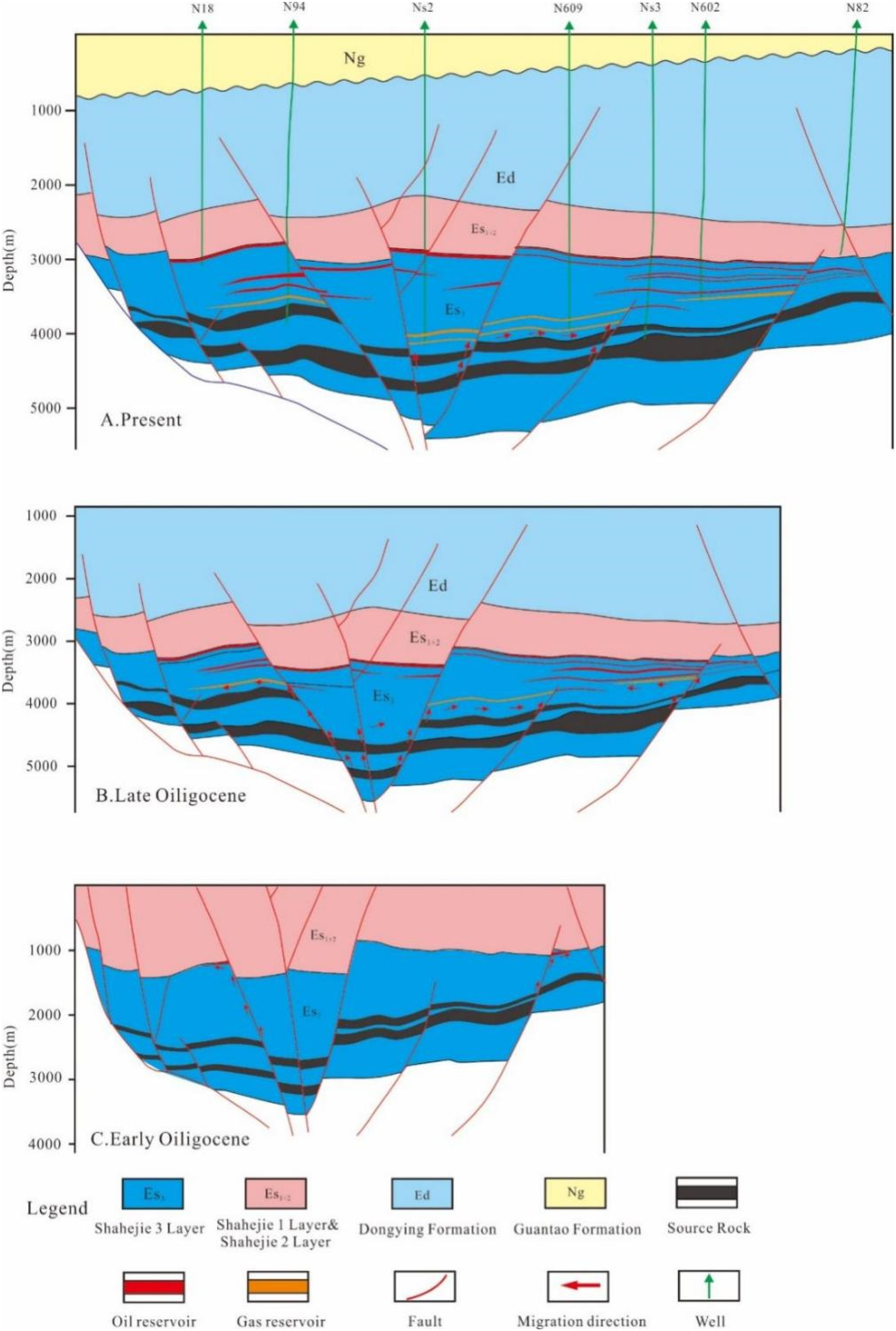
Hydrocarbon charging process and accumulation model of deep reservoirs in the northern part of the eastern Liaohe depression. A is the current NW-trending reservoir profile AB;B is the NW-trending reservoir profile AB before lifting; C is the NW-trending reservoir profile AB in the Early Oligocene.
During the late Oligocene, the northern part of the eastern Liaohe Depression continued to subside, resulting in an increased depth of the hydrocarbon source rocks in the Es3 formation. Consequently, the Ro value of these source rocks reached 1.3%, indicating that they entered the high-maturity stage. As a result, substantial quantities of mature hydrocarbon were released. Because of various factors, including the collision of the Indian plate and the subduction of the Pacific plate, the eastern Liaohe Depression was situated within a strong right-rotation extensional regional tectonic stress field. At this time, the Niushen 2 fault, the Niu 74 fault, and the Niu Qing fault remained active and partially open, exhibiting fault activity rates exceeding 7 m/Ma. Hydrocarbon continued to be migrated along the faults into the reservoirs of the upper stratum system and laterally along the connecting migration sandstone bodies toward the structural height. These mature–highly mature hydrocarbons were captured by the sandstone reservoir in the Es31 formation, forming blue fluorescent oil inclusions and two-phase gas‒liquid inclusions (Figure 4(c) and (g)). The majority of these inclusions are present in early fractures and quartz enlargements. The inclusions developed from approximately 30.8 to 27.5 Ma on the basis of their homogenization temperatures and burial history and represent the main hydrocarbon reservoir in the study area.
After a brief uplift at the end of the Oligocene, the study area entered a subsidence phase again in the Neogene to the Quaternary. The hydrocarbon source rocks in the Es3 formation underwent a full organic matter maturation evolutionary history and further matured into a mature to highly mature evolutionary stage, with large-scale hydrocarbon generation and discharge again. During this period, magmatic activity was intense in certain areas of the depression, resulting in several local anomalously high geothermal fields. This activity promoted the maturation of hydrocarbon source rocks to the overmature period and created favorable conditions for extensive natural gas production. The faults were no longer active during this period and were closed. A substantial quantity of hydrocarbons migrated and accumulated in the deep sandstone reservoir, where the reservoir properties of the connected sands in contact with the hydrocarbon source rocks were favorable (Figure 14(A)). Gray gas inclusions and oil inclusions with blue‒white fluorescence were captured in reservoirs buried at depths greater than 3800 m (Figure 4). The gas inclusions are mostly isolated or in clusters on the surfaces of quartz and feldspar and on the larger edges of quartz. However, not many gas inclusions are founded in reservoirs far from the hydrocarbon source rock formation. This finding also proves that the mature–highly mature hydrocarbons generation from the Es3 formation were not migrated vertically over long distances through the faults to the upper formations. The homogenization temperatures of the fluid inclusions and the burial history of the formation suggest that the second stage of hydrocarbons charging from 8.7 Ma to the nowadays.
The migration modes and accumulation positions of hydrocarbon charging during the two periods differ, allowing for the classification of the deep hydrocarbon in the northern part of the eastern Liaohe depression into two types: early source–reservoir separation and late source–reservoir adjacency. The early source–reservoir separation accumulation mode developed during the first period of hydrocarbons charging, primarily occurring in the upper sandstone reservoirs of the Es3 formation, with faults and sandstone bodies serving as the migration channels for the hydrocarbons charging. The accumulation and distribution of this type of deep hydrocarbon reservoirs are influenced by migration conditions. The late source–reservoir adjacency accumulation mode exists in the middle and lower reservoirs of the Es3 formation and formed during the second period of the hydrocarbons charging. In this case, the sandstone bodies that serve as reservoirs are in direct contact with the source rocks, allowing hydrocarbons to accumulate in the reservoir after being generated from the source rocks. The accumulation and distribution of this type of reservoir are significantly affected by the distribution of the source rocks and the connected sandstone reservoirs.
Conclusions
The fluorescence characteristics of the inclusions, lithological characteristics, and micro-thermometry measurements of the fluid inclusions indicate that the deep hydrocarbon reservoirs in the northern part of the eastern Liaohe Depression experienced two periods of hydrocarbon charging: the late Oligocene (32.9–27.5 Ma) and the period from the late Neogene to the present (8.7–0 Ma). Based on geological data and the history of tectonic evolution, the upper and middle parts of the Es3 formation within the study area exhibit a widespread distribution of migrated sandstone bodies with favorable porosity and permeability. The oil source faults linking the hydrocarbon source rocks to the upper reservoirs opened during the first period of hydrocarbons charging and closed during the second period. The subsidence before the Eocene to late Oligocene uplift allowed hydrocarbon source rocks to discharge hydrocarbons for the first time and facilitated their entry into the upper Es3 reservoirs, while subsequent subsidence during the late Oligocene led to the release of mature to highly mature hydrocarbons, which, unable to be migrated through the faults, instead entered the connected sands nearby. There are two types of hydrocarbon migration and accumulations in the northern part of the eastern Liaohe depression:early source–reservoir separation and late source–reservoir adjacency. Therefore, faults near hydrocarbon source rocks and the layers adjacent to hydrocarbon source rocks represent important hydrocarbon exploration targets. Therefore, the faults and sandstone reservoirs near the hydrocarbon source rocks are significant exploration targets for deep hydrocarbon.
Footnotes
Acknowledgements
This study was supported by the National Natural Science Foundation of China (41972140) and the National Science and Technology Major Project (2016ZX05006–005). We appreciate the thoughtful discussions and suggestions from Cai Guogang at the Research Institute of Liaohe Oilfield Company.
Declaration of conflicting interests
The authors declared no potential conflicts of interest with respect to the research, authorship, and/or publication of this article.
Funding
The authors disclosed receipt of the following financial support for the research, authorship, and/or publication of this article: This work was supported by the National Science and Technology Major Project, National Natural Science Foundation of China (grant number 2016ZX05006-005, 41972140).