
Abstract
Based on the research results of stratigraphic sedimentary facies, plane maps of sedimentary facies for four periods of the Neogene terrestrial foreland basin in Southwest Tarim were compiled. Research results conclude that the Neogene Miocene developed alluvial fan facies, fan delta facies, and lacustrine facies successively from the piedmont belt to the Maigaiti Slope. During the sedimentation of the Miocene Anju’an Formation, the lake range expanded to its maximum. According to the new division scheme for five-order sequences in prototype sedimentary basin, the stratigraphic sequence of a terrestrial foreland basin was divided and compared, and a sequence development and evolution model was established. Research results show that: (1) the Neogene–Quaternary is a typical type I sedimentary sequence with huge thickness; (2) the Neogene is a period of tectonic compression and flexural subsidence sedimentation in the foreland basin; with the maximum lake flooding surface at the top of the Miocene Anju’an Formation as the boundary, the lower part is a second-order super-sequence of the lacustrine transgression system tracts (TST), the upper part is a second-order super-sequence of the highstand system tracts (HST), and the Quaternary is a second-order super-sequence of the lowstand system tracts (LST) in forced lacustrine regression caused by the Late Himalayan tectonic movement; (3) the classic sequence stratigraphy made an error in establishing the theoretical model of marine type I sequences, as it placed the LST in the wrong position. The corrected type I sequences are in the order of TST, HST, and LST. (4) Finally, two examples were applied to demonstrate the development position of the LST, indicating that whether it is a marine or terrestrial prototype sedimentary basin, the LST was developed during the late stage of tectonic compression and uplift in a basin, and is the sedimentary sequence at the top of the prototype sedimentary basin.
Introduction
After more than 70 years of mineral exploration, geological research, and oil and gas exploration in the Neogene–Quaternary terrestrial foreland basin in southwest Tarim, a condensate gas reservoir of the Kekeya Miocene Anju'an Formation was discovered in the second row of the compressional fold belt in the front of the Yecheng Sag, and a damaged residual oil reservoir was found in the Miocene Pakabulak Formation of the ground eroded anticline in the northern Kashgar Sag (He et al., 1997; Liu et al., 2006). In addition, multiple exploration wells have seen gas logging in the Neogene, showing good exploration prospects.
The theoretical models of sequence stratigraphy proposed by early scholars were mainly based on marine sedimentary basins (Adabi et al., 2010; Galloway, 1989; Van Wagoner et al., 1988; Wang et al., 2022), and many scholars have conducted exploratory researches on the application of sequence stratigraphy principles to terrestrial petroliferous basins (Borsa et al., 2023; Gu, 1995; Guo et al., 1998; Jia, 2009; Li et al., 1995; Ren et al., 2017; Zhu et al., 2011). However, due to the inherent problems in the theory and technology of sequence stratigraphy, such as the research objectives of sequence stratigraphy, the distribution location of lowstand system tract (LST for short), the definition of sequence stratigraphic grading, the issue of lithological structure in the systems tracts, the issue of sea level rise and fall curves, etc, the standardized industrial application of sequence stratigraphy has been seriously restricted (Catuneanu et al., 2009; Catuneanu and Zecchin, 2020; Wang, 2007; Wu, 2017).
The development of sequence stratigraphy in a terrestrial basin has its unique characteristics. For example, terrestrial basins are completely unaffected by global sea level fluctuations, and tectonic fluctuations basically control the initial formation and sedimentary evolution of terrestrial lacustrine basins; the strata above the unconformity at the bottom of a terrestrial lacustrine basin must experience the process that lake water expand gradually from scratch, thus the bottom must be a lacustrine transgression system tract (TST for short). These unique conditions provide excellent research perspective for the standardization of sequence stratigraphy.
On the basis of previous research (Chen et al., 1998; Fan et al., 2015; He et al., 2015; Jin et al., 2001), this article conducts a detailed study on the stratigraphy, sedimentary facies, sequence stratigraphy, and tectonic cycles of the Neogene–Quaternary terrestrial foreland basin in southwestern Tarim. A division scheme of five-order sequences for the terrestrial basin was established, a basin-order sequence development and evolution model was established, and the superimposed law of the three system tracts of the type I sequences in a terrestrial basin was studied. Provide better application standards and theoretical support for the industrial application of sequence stratigraphy standardization.
Geological setting
Tectonic setting
The Neogene–Quaternary terrestrial foreland basin in southwest region of the Tarim Basin (Southwest Tarim for short) was located in piedmont belts of the West Kunlun Mountains and the South Tianshan Mountains on the southwest edge of the Tarim Basin. It is distributed in a narrow and long shape in NNW direction, nearly parallel to the West Kunlun Mountains. The basin covers an area of about 60,000 km2 and has the maximum sedimentary thickness more than 12,000 m, being the thickest area of the Neogene–Quaternary deposits in the Tarim Basin (Figure 1).
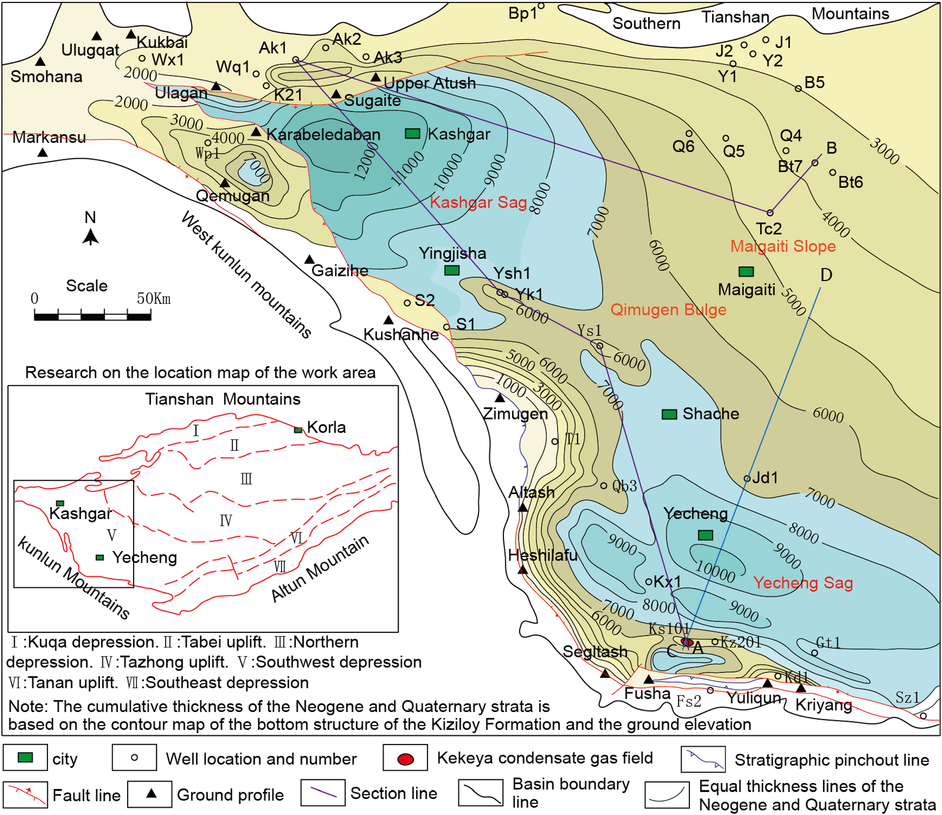
Tectonic units, cross-sectional positions, and thickness contour line map of the Neogene–Quaternary foreland basin in Southwest Tarim.
The Southwest Tarim Neogene–Quaternary terrestrial foreland basin can be divided into four tectonic units, namely Kashgar Sag, Qimugen Bulge, Yecheng Sag, and Maigaiti Slope. The sedimentary thickness in the mountain front depression is huge, and gradually decreases toward the Maigaiti Slope (He et al., 2015).
The Tarim Basin is a superimposed composite basin (He et al., 2005), and three stages of prototype sedimentary basin were superimposed in Southwest Tarim during the Mesozoic-Cenozoic period. During the Jurassic-Early Cretaceous period, the first stage of extensional terrestrial rift-fault basin extending in strip shape along the West Kunlun Mountains in Southwest Tarim was formed (Qin, 2005; Ren et al., 2017), depositing coarse clastic rocks interbedded with thin coal seams in alluvial fan and braided river delta facies. During the Late Cretaceous-Paleogene period, seawater entered the Southwest Tarim, forming the second stage of the ancient bay-type marine rift-depression basin (Xi et al., 2020; Yong and Shan, 1996), depositing very thick marine gypsum-salt rock and carbonate layers. During the Oligocene period, due to plate uplift and tectonic deformation, seawater withdrew from the Southwest Tarim.
During the Neogene period, with the long-distance tectonic effect of the collision between the southern Indian subcontinent and the Eurasian continental plate, a strong SN-trending compressive stress field was induced to spread to the Tarim Basin, resulting in the uplift of the thrust structure of the West Kunlun Mountains and the large-scale strike-slip thrust movement of the basin boundary faults (Wu et al., 2020). The collision and uplift of the South Tianshan orogenic belt and the West Kunlun Mountains formed the northwest dam, and ended the history of seawater intrusion, then the third stage basin was formed in piedmont belt of the Southwest Tarim (i.e. the terrestrial foreland basin). The piedmont basement was subjected to compressive and flexural subsidence, and received very thick Neogene terrestrial sedimentary strata (Chen et al., 1998).
Due to the increasing intensity of uplift and compression in the West Kunlun Mountains and South Tianshan orogenic belt during the Quaternary period, the pre-Quaternary basement began to be involved in foreland deformation, forming a series of compressional long-axis anticline structures parallel to the orogenic belt, then it entered the sedimentary stage of the segmented foreland basin in the late stage of foreland basin development (Liu, 1995). While the anticlines were uplifted, the syncline zones continued to sink and deposit, and the piedmont belt received very thick Quaternary conglomerate deposits in alluvial fan facies (Chen et al., 2000; Hao et al., 2002).
Regional strata
The Neogene in the piedmont belt of Southwest Tarim consists of the Miocene Wuqia Group and the Pliocene Atushi Formation. The Miocene Wuqia Group includes the Keziloyi Formation, Anju'an Formation, and Pakbulake Formation. The thickest sedimentary area is the Kekeya region, up to 3900 m thick, sedimentation time limit 16.7 Ma. The thickest sedimentary area of the Pliocene Atushi Formation is in the Yingjisha area, up to 3750 m thick, sedimentary time limit 2.75 Ma. The Quaternary consists of the Pleistocene and Holocene series, including the Xiyu Formation, Wusu Group, and Xinjiang Group in the Pleistocene. The maximum thickness of the Quaternary conglomerate sediment in the surface profile of the piedmont belt can reach 3000 m, sedimentation time limit 2.58 Ma.
The surface between the Neogene bottom and underlying strata is a basin-order unconformity (Figure 2). The Miocene Keziluoyi Formation in the front of the mountain is mainly composed of conglomerate and sandstone. The lithology of Anju’an Formation is mainly composed of mudstone interbedded with siltstone and gypsum rock. The lithology of the Pakabulak Formation is mainly composed of sandstone and mudstone interbedded with gypsum rock.
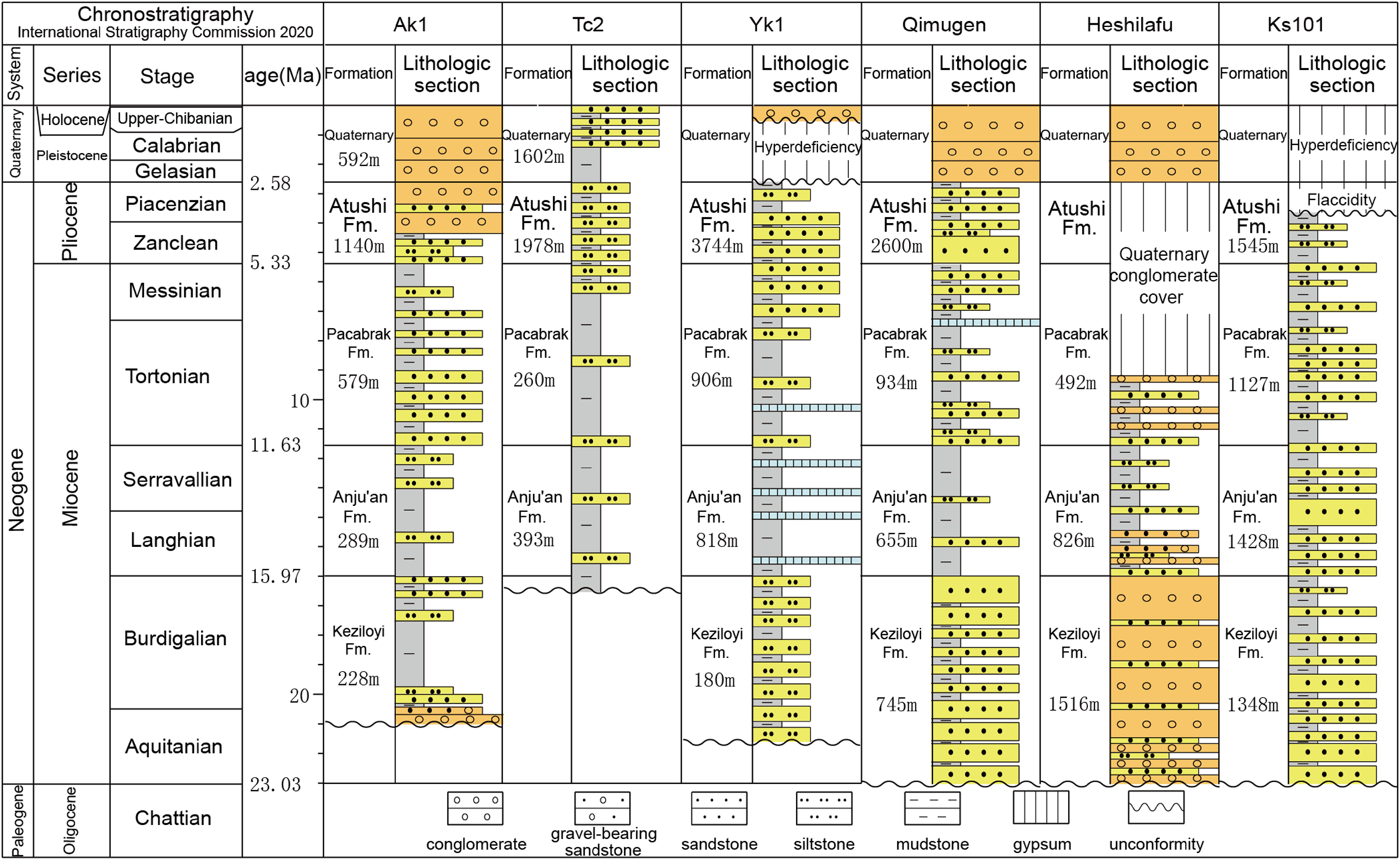
Chronostratigraphic and Regional Representative Lithological Sections of the Neogene–Quaternary in Southwest Tarim Foreland Basin.
The Quaternary and Neogene are in unconformity-conformity contact. The Quaternary consists of the Pleistocene Xiyu Formation, Wusu Group, Xinjiang Group, and Holocene. The Xiyu Formation has been consolidated into rock, while the distribution of other strata is limited, mostly being loose or weakly consolidated deposits. The Xiyu Formation is a thick gray massive consolidated conglomerate interbedded with thin or lenticular yellow sandstone in the piedmont belt. In the Maigaiti Slope, its facies transforms into yellow mudstone and sandstone, which is significantly different from the reddish-brown dominated strata of the underlying Pliocene Atushi Formation.
Comparative analysis of strata, sequence stratigraphy, and sedimentary facies
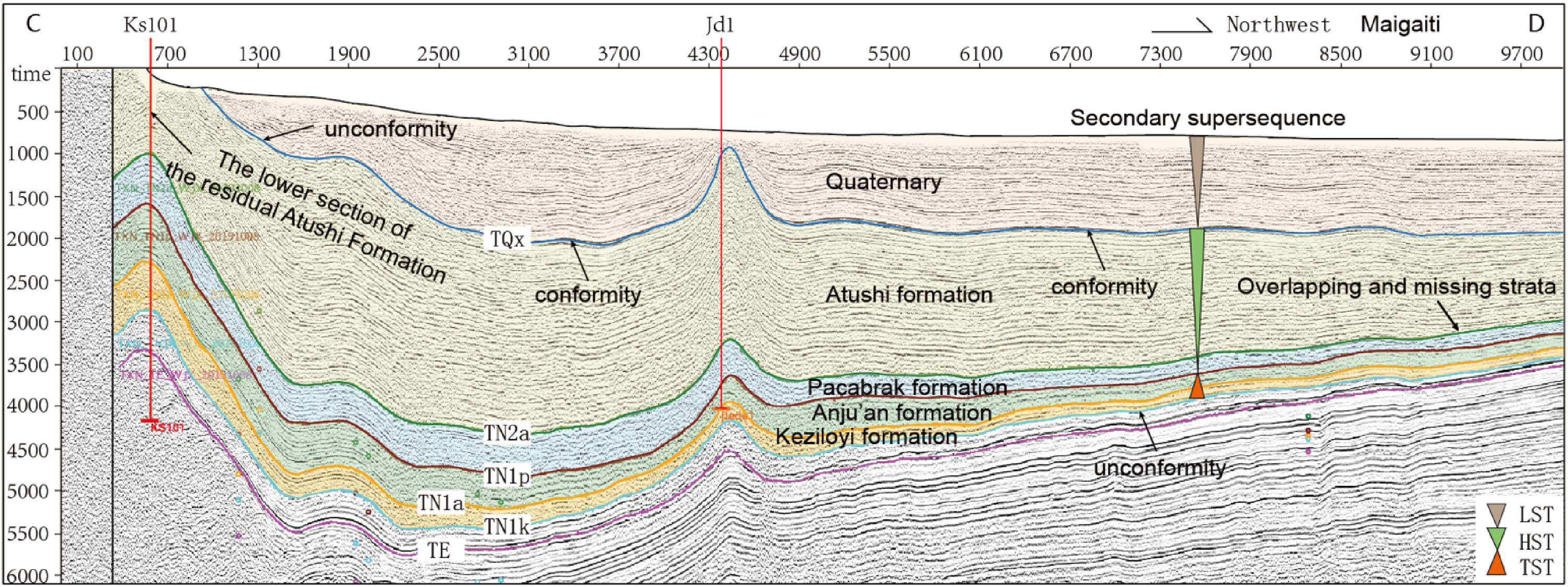
Comparison of large cross-section shows that the overall sedimentary characteristics of the foreland basin are the huge thickness of sediments in the piedmont belt of the West Kunlun Mountains, and overlapped and thinning toward the northern Kashgar and Maigaiti Slope. The Qimugen Bulge exists in the Miocene, separating the Kashgar Sag and Yecheng Sag (Figure. 3).
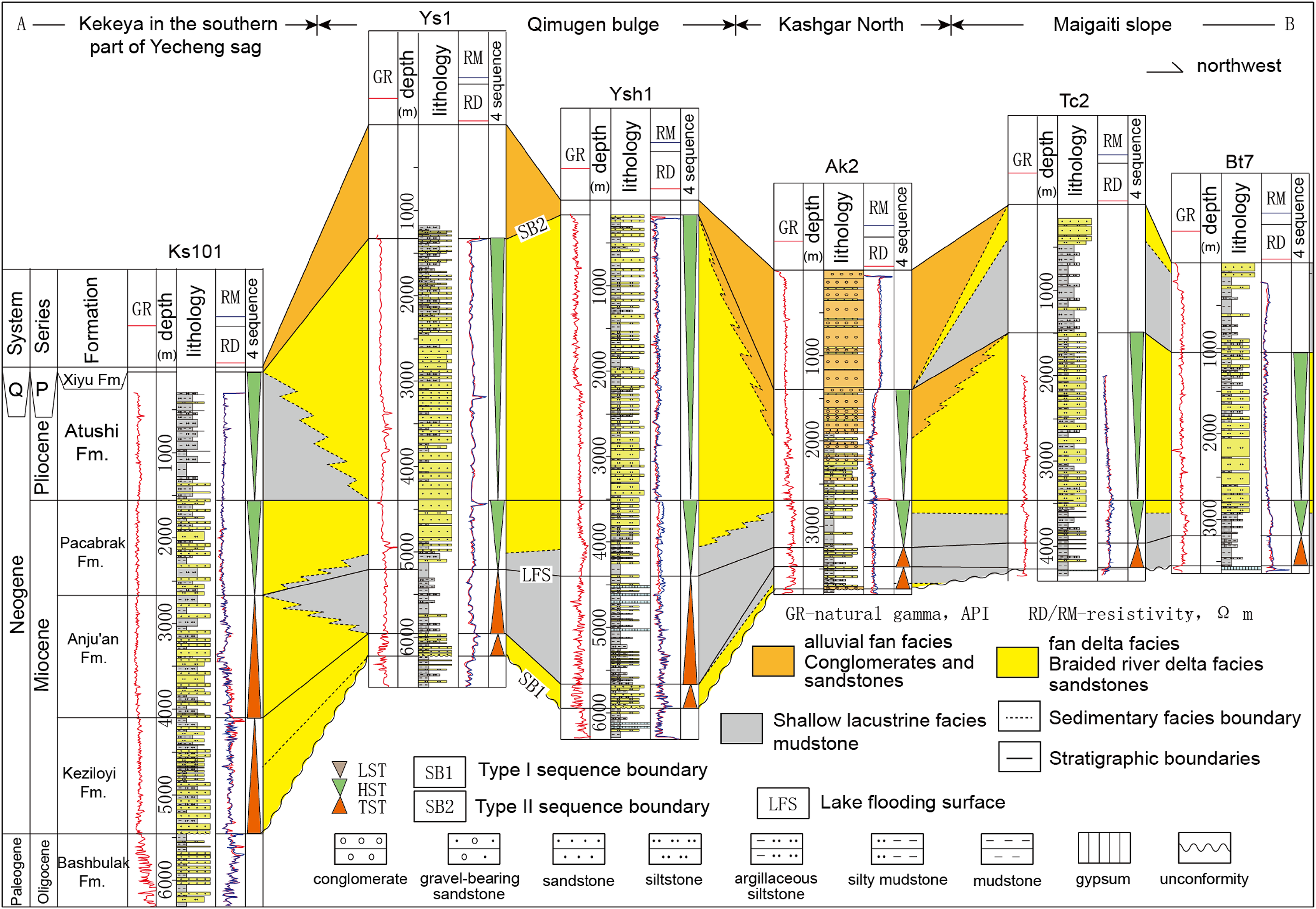
Comparison profile of Neogene–Quaternary strata, sequence stratigraphy, and sedimentary facies in Southwest Tarim (the position of section is shown in Figure 1).
There is a type I unconformity sequence boundary (SB1) between the bottom of the Neogene and the Paleogene marine strata, and a type II unconformity-conformity sequence boundary (SB2) between the top of the Neogene and the Quaternary strata.
The Miocene Keziloyi Formation in the piedmont belt of the West Kunlun Mountains is mainly composed of very thick brown-gray alluvial fan conglomerate interbedded with sandstone, or brown-gray fan delta sandstone interbedded with mudstone. To the Qimugen Bulge, the interbedded sandstone and mudstone of the fan delta front are significantly thinned. The Keziloyi Formation in the northern Kashgar region far from the piedmont belt of the West Kunlun Mountains is characterized by grayish-green and varicolored lacustrine mudstone interbedded with thin silty-fine sandstone and thin gypsum, and becomes thinner, overlapped and absent to the Maigaiti Slope. The well-tie sequence analysis suggests that the Keziloyi Formation is a fourth-order parasequence group of the TST.
During the sedimentation of the Miocene Anju’an Formation, it was in a temperate humid climate zone. The profiles show that a huge shallow lake with fresh water-brackish water appeared during the sedimentation of the Anju’an Formation, with a water depth of less than 20 m (Hao et al., 2002; Zhang et al., 1999). It still belonged to a wide-shallow lake, characterized by gray-green, gray, and reddish-brown mudstone interbedded with thin gypsum rock. During the late sedimentary period of the Anju’an Formation, the lake area expanded to its maximum scope, with the appearance of the maximum lacustrine flooding surface (LFS for short). The Anju’an Formation in the piedmont belt of the West Kunlun Mountains still develops very thick sand bodies of retrogradational and aggradational fan deltas around the lake edge, for example, in the Kekeya area. The well-tie sequence analysis suggests that the Anju’an Formation is a fourth-order parasequence group of the lacustrine TST.
During the sedimentation of the Miocene Pakabulak Formation, the lake area began to shrink. Based on the progradation of fan delta sand bodies toward the lake area and the shrinking of the lake area, it is believed that the Pakabulak Formation is a fourth-order parasequence group of the highstand system tract (HST for short).
During the sedimentation of the Pliocene Atushi Formation, there were significant changes in the provenance system and sedimentary pattern. Except to the accelerated uplifting of the West Kunlun Mountains, the South Tianshan Mountains began to rapidly uplift to become a new provenance area. The Atushi Formation in front of the South Tianshan Mountains exhibits a reverse cycle of lower sand and upper gravel. The lake area shrank and was separated, and the Qimugen Bulge occurred compensatory decline. Along with the Maigaiti Slope, it received the deposits of thick green sandstone interbedded with mudstone in the braided river delta; the Kekeya area formed a shallow lacustrine area mainly composed of mudstone deposit, and well-tie sequence analysis suggests that the Atushi Formation is a fourth order parasequence group of the HST.
During the Quaternary period, the structure and sedimentary pattern in southwest Tarim Basin underwent sharp changes. The piedmont belt was affected by strong compression tectonic movements, resulting in a series of compression synsedimentary anticlines parallel to the West Kunlun Mountains and South Tianshan Mountains. The tops of the anticlines were eroded to varying degrees, such as the upper member of the Atushi Formation in Well Ks101 was eroded. The synclines at two wings of the anticlines deposited a huge thickness of the Quaternary. Partial anticlines (such as the Ys1 anticline) were formed relatively late, and their tops are still covered with thicker alluvial fan-braided river delta conglomerate, sandstone interbedded with mudstone. Shallow lacustrine mudstone sedimentary areas appear in some areas of the Maigaiti Slope. The well-tie sequence analysis suggests that the Quaternary is a sedimentary sequence of the LST.
Planar distribution of sedimentary facies
Determination of provenance
During the sedimentation of the Miocene, only the West Kunlun Mountains was the main provenance, while the South Tianshan Mountains was not the provenance. Based on the fact that the sand/formation ratio contour of the Miocene series are mainly distributed around the western Kunlun Mountains toward the Maigaiti Slope and the southern Tianshan Mountains, with a decreasing distribution, the South Tianshan Mountains became another main provenance and changed the sedimentary pattern during the sedimentation of the Atushi Formation in the Pliocene.
Determination of sedimentary facies zones
The determination of sedimentary facies zones is mainly based on the sandstone/formation ratio contours. Combined with the lithology and thickness of the outcrop sections, sedimentary facies zones are comprehensively divided by stratigraphic thickness contours determined by seismic method.
Planar distribution of sedimentary facies
The Keziloyi Formation of the Neogene Miocene is the first set of strata deposited after the formation of the terrestrial foreland basin(Figure 4(a)). Two protruding alluvial fan–fan delta plain facies zones were developed in piedmont belt of the West Kunlun Mountains, mainly composed of very thick conglomerates and sandstones interbedded with mudstones. Other areas in piedmont belt were wider fan delta front facies, mainly composed of very thick sandstones interbedded with mudstones. The northern Kashgar region in piedmont belt of the South Tianshan Mountains and the Maigaiti Slope were shore-shallow lacustrine facies, mainly composed of mudstones interbedded with thin siltstones, with a phenomenon of overlapped and absent strata.
The most significant feature of the sedimentary period of the Miocene Anju'an Formation in the Neogene is the expansion of the shallow lacustrine facies area and the reaching of the maximum lake basin period (Figure 4(b)), with a water depth of less than 20 m. The northern Kashgar, Qimugen Bulge and Qb3-Kx1 well block were transformed into the shore-shallow lacustrine facies. In the Kekeya oilfield of the Yecheng Sag and the Gt1-Jd1 well block, the fan delta plain-front sedimentary facies was still continued, with very thick fan delta channel sandstone.
During the sedimentation of the Neogene Miocene Pakabulak Formation, the shallow lacustrine facies significantly shrank, and there was a reduced shallow lacustrine facies remaining in the Kx1 well block of the Yecheng Sag (Figure 4(c)). During this period, there was no alluvial fan facies in the piedmont belt of the West Kunlun Mountains, but widely developed fan delta plain-front facies. The front delta-shallow lacustrine facies retreated to the Maigaiti Slope-northern Kashgar region.
During the sedimentation of the lower member of the Pliocene Atushi Formation, the sedimentary pattern underwent significant changes (Figure 4(d)). Due to the influence of tectonic movements, the South Tianshan Mountains began to undergo intense uplifting to form a provenance area. In the northern Kashgar region, a braided river delta plain-front facies appeared, and sedimentary sandbodies entered the shallow lacustrine facies. In the piedmont belt of the West Kunlun Mountains, in the Gaizihe-Kushanhe area, alluvial fan facies reappeared. The sedimentary pattern in the Qimugen Bulge-Maigaiti Slope transformed from the shore-shallow lacustrine facies to the braided river delta plain-front facies of the Miocene, separating the Kashgar Sag and the Yecheng Sag. The Kekeya and Gt1 well block of the Yecheng Sag transformed from the fan delta front facies in the Miocene to the shallow lacustrine facies and the shore lacustrine-front delta facies in the lower part of the Pliocene. The very thick shallow lacustrine mudstone strata formed a unique reservoir-caprock assemblage in the Kekeya oilfield.
Sequence stratigraphic division for the terrestrial foreland basin
Seismic sequence division and tectonic cycle interpretation
In 2019, Exploration and Development Research Institute of PetroChina Tarim Oilfield Company conducted a new round of geophysical exploration in the Southwest Tarim to unify strata (Figure 5). The stratigraphic calibration was carried out using the bottoms of five geological horizons (TN1k, TN1a, TN1p, TN2a, and TQx) and corresponding through-well seismic reflection interfaces in Well Ks101. Then, Well Ks101 was used as the anchor point to radiate to the surrounding areas for seismic horizon tracking and unification of underground geological stratification interfaces. This horizon unification method basically avoids the diachronous phenomenon of stratification for “formations” in lithological strata, achieving the unity and isochronicity of underground geological stratification.
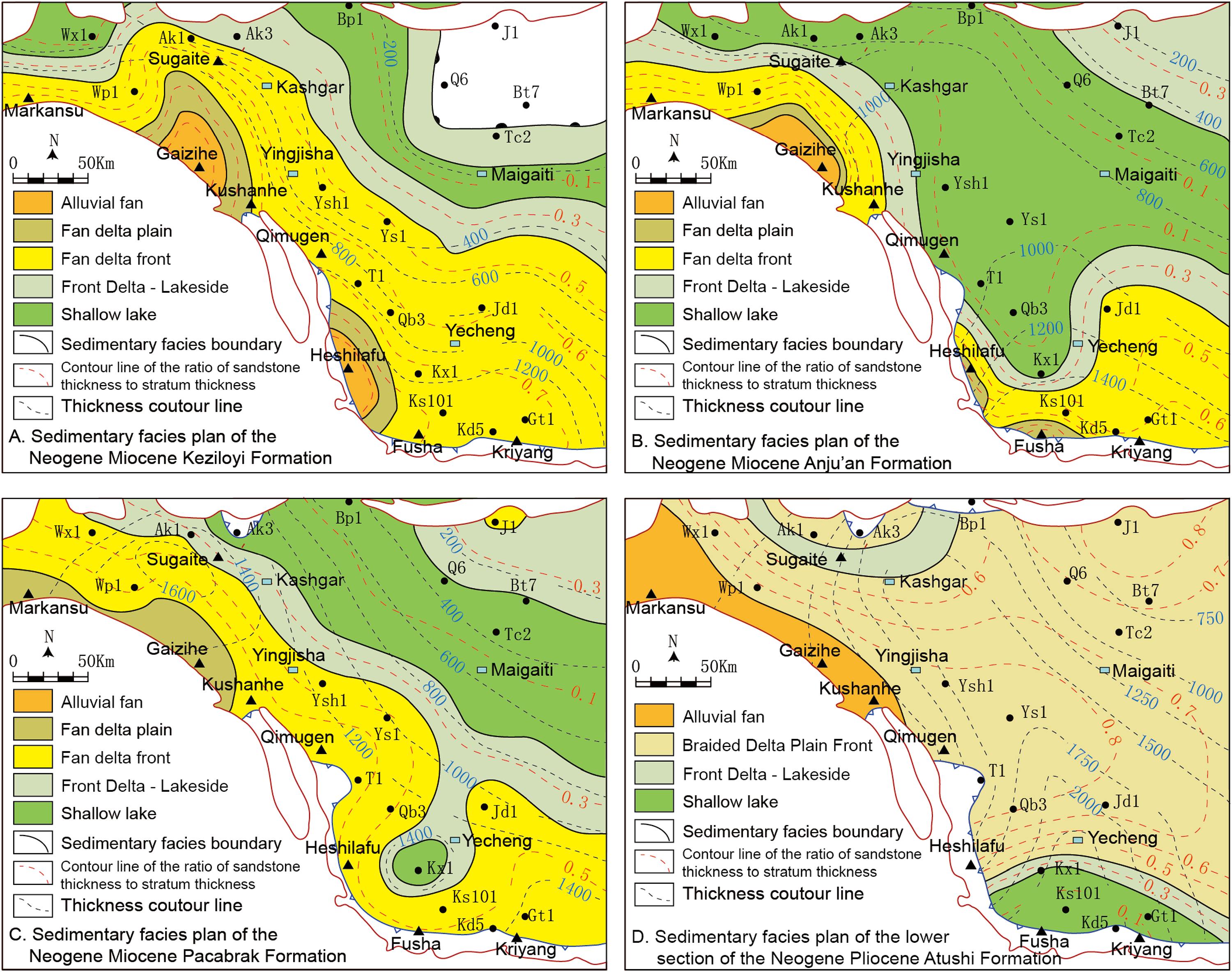
Sedimentary facies plan of the three Formation of the Neogene Miocene and the lower section of the Pliocene Atushi Formation in Southwest Tarim foreland basin.
Seismic sequence division and interpretation profile of the Neogene–Quaternary terrestrial foreland basin in southwest Tarim (the position of section is shown in Figure 1).
The seismic reflection interfaces within the Neogene all exhibit continuous conformity, indicating that the Neogene in the piedmont belt of the Southwest Tarim was a continuous sedimentation with continuous subsidence. However, the Quaternary was a period of intense tectonic changes, and a series of compressional long-axis anticlines parallel to the orogenic belt began to appear in the piedmont belt. Wide and gentle synclines occurred between the anticlines. The closer the anticline was to the orogenic belt, the higher the uplift amplitude of the anticline, and the more severe the erosion of the top strata. For instance, in the Kekeya anticline structure, the upper member of the Atushi Formation at the top was completely eroded, leaving only the lower member of the Atushi Formation; the anticline structures far from the orogenic belt (such as the Jd1 anticline) have relatively preserved Neogene strata. The Neogene and Quaternary in the syncline area between the anticline structures are continuous sediments that contact in conformity.
Decisive control of tectonic cycle on sequence stratigraphic cycle
The Middle Himalayan movement, which began at 23.03 Ma, formed a basin-order unconformity at the bottom of the Neogene. Continuous tectonic stress compression caused the basement of the piedmont belt of the Southwest Tarim to occur flexural subsidence, entering a period of stable tectonic subsidence. The Miocene was a period of slow tectonic subsidence, forming cyclic sedimentary sequences of TST (including the Keziloyi Formation and Anju'an Formation) and HST (including the Pakabulak Formation). The Pliocene was a period of rapid tectonic subsidence, during which abundant coarse debris sources entered the basin to form an HST sedimentary sequence.
The compressive stress suddenly increased during the Quaternary period, entering the late Himalayan movement period and continuing to this day. The pre-Quaternary basement began to be involved in foreland deformation, forming a series of compressional long-axis anticlines and synclines parallel to the orogenic belt. It entered a parallel period of tectonic uplift erosion-subsiding sedimentation, forming a Quaternary LST sedimentary sequence.
Principle basis and technical description of sequence division scheme
The basic principle of sequence stratigraphy is the principle of gravity differentiation of clastic sediments. The research goal of sequence stratigraphy is the prototype basins. Because the top and bottom of the prototype basin are basin level unconformities.
Two system tracts are formed according to the accommodation changes of the lake-land transition zone. There are two criteria for distinguishing TST: one is that the lacustrine area is expanding, and the other is that the sedimentary sandbodies in the lake-land transition zone are retrogradational and aggradational. There are also two criteria for distinguishing HST: one is that the lacustrine area is shrinking, and the other is that the sedimentary sandbodies in the lake-land transition zone are aggradational and prograding.
System tracts refers to a set of isochronous strata deposited under the background of transgressive or high water level. Therefore at the same time as sequence classification, the sedimentary background of the system tract must be described according to the sequence classification.
The division of first-order mega-sequences varies among different scholars, and using age constraints to divide first-order mega-sequences is even less technically feasible (Wang and Shi, 1998). Therefore, this article restricts the first-order mega-sequence to the prototype basin. In seismic stratigraphy, the first order mega-sequence belongs to a tectonic layer.
The fifth-order parasequence is the basic sequence of the sequence stratigraphic division scheme. The fifth-order parasequence and lithological segments correspond to each other. Below the lithological segments are sand groups and sand layers, corresponding to a sequence division of sixth-order subsequence and the lowest seventh-order microsequence.
The superimposed order of the type I sequence system tracts in the Neogene–Quaternary terrestrial foreland basin in Southwest Tarim is different from that of the type I sequence system tract in classical sequence stratigraphy. From bottom to top, it is composed of the superimposition of the TST, HST, and LST.
The Quaternary LST in Southwest Tarim is separated sedimentary sequence, which is the topmost sequence of the second-order super-sequence. The divisions of third-, fourth-, and fifth-order sequences do not involve the LST, as the LST cannot be subdivided.
Classification of five-order sequences in terrestrial foreland basin
Although the Neogene–Quaternary terrestrial foreland basin in Southwest Tarim has very thick sediments, the development of sequence stratigraphy is relatively simple, with only one period of maximum lacustrine flooding surface (LFS), so only a typical type I sequence is developed (Figure 6). Based on the latest five-order sequence division scheme of marine prototype sedimentary basins (Ma et al., 2019, 2020), and comprehensive research on strata, sedimentary facies, interface characteristics, and tectonic cycles, this article classified and interpreted the sequence stratigraphy of the Neogene–Quaternary terrestrial foreland basin in Southwest Tarim, and established a five-order sequence division scheme for the terrestrial foreland basin.
First-order mega-sequence: Named 1SQNQ, corresponding to the third tectonic layer. The bottom is an unconformity sequence boundary at the basin level of the Neogene (SB1), and the top is the current ground sedimentary interface of the Quaternary (still being deposited), with a sedimentation age of about 23.03 Ma. Second-order super-sequence: Usually, the second-order super-sequence is divided by the maximum LFS during the maximum period of lake area expansion. The top surface of the Anju’an Formation in Southwest Tarim is the LFS, so it can be divided into two second-order super-sequences. However, there is also an LST in the Quaternary at the top, so it can be divided into three second-order super-sequences. The Keziloyi Formation and Anju'an Formation are a second-order super-sequence (2SQN1k-a) of an overall TST, while the upper Pakabulak Formation and Atushi Formation are a second-order super-sequence (2SQN1p-N2a) of an overall HST. The top Quaternary is the sedimentary sequence (2SQQ) of a LST, which constitutes a typical type I sequence, namely the cyclic combination sequence of the TST, HST, and LST. Third-order sequences: The bottom of the Neogene in Southwest Tarim is a type I unconformity sequence boundary, and the top is a type II sequence boundary composed of unconformity-conformity. The top of the Anju’an Formation inside is the separation of the maximum LFS. Therefore, the Neogene as a whole forms a third-order sequence 3SQN, manifested as the lower Keziloyi Formation and Anju'an Formation being two superimposed fourth-order parasequence sets of a TST, the upper Pakabulak Formation and Atushi Formation are two superimposed fourth-order parasequence sets of a HST, forming a combined sequence of a third-order TST–HST cycle. The sedimentation age is 20.45 Ma, and the identification mark is the presence of a huge mudstone wedge from shallow lake to land direction. The top of the wedge is the lacustrine flooding surface during the period of maximum lake area expansion. Fourth-order parasequence sets: The fourth-order parasequence sets of the Neogene foreland basin in Southwest Tarim is mainly divided into four parasequence sets based on lithology. Among them, the Keziloyi Formation (4SQN1k) and Anju’an Formation (4SQN1a) are both fourth-order parasequence sets of a TST deposited during the expansion period of the lake area, with sandbodies distributed in aggradational and retrogradational manner. The Pakabulak Formation (4SQN1k) and Atushi Formation (4SQN2a) are both fourth-order parasequence sets of an HST deposited during the contraction period of the lake area, with sandbodies distributed in aggradational and prograding manner. Fifth-order parasequence: They are the basic units of sequence stratigraphy research, composed of a single system tract. The fifth-order parasequence of the Neogene in Southwest Tarim are mainly composed of lithological intervals and can be divided into eight parasequences.
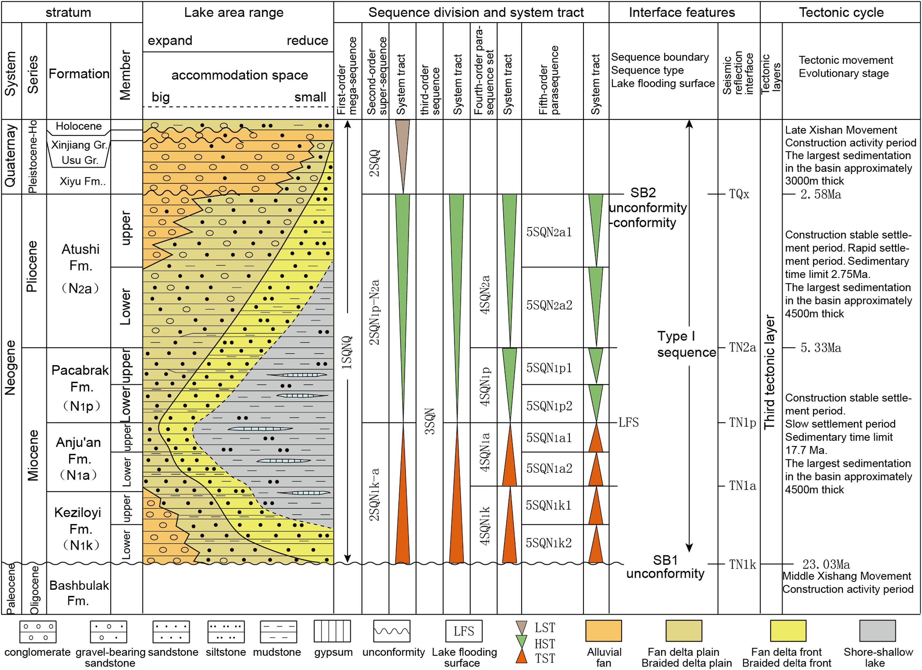
Stratum, sequence stratigraphy, interface characteristics, and tectonic cycle division scheme of the Neogene–Quaternary terrestrial foreland basin in Southwest Tarim.
Geological modeling of sequence in terrestrial foreland basin
The Neogene–Quaternary terrestrial foreland basin in the Southwest Tarim can be divided into two evolutionary stages based on tectonic-sedimentary evolution: the stable subsidence-sedimentation stage of the Neogene foreland basin, and the tectonic deformation, forced lacustrine regression, and eroded sedimentation stage of the Quaternary foreland basin. Therefore, conceptual models of strata, sedimentation, tectonic, and sequence sedimentary evolution can be established according to two stages (Figure 7).
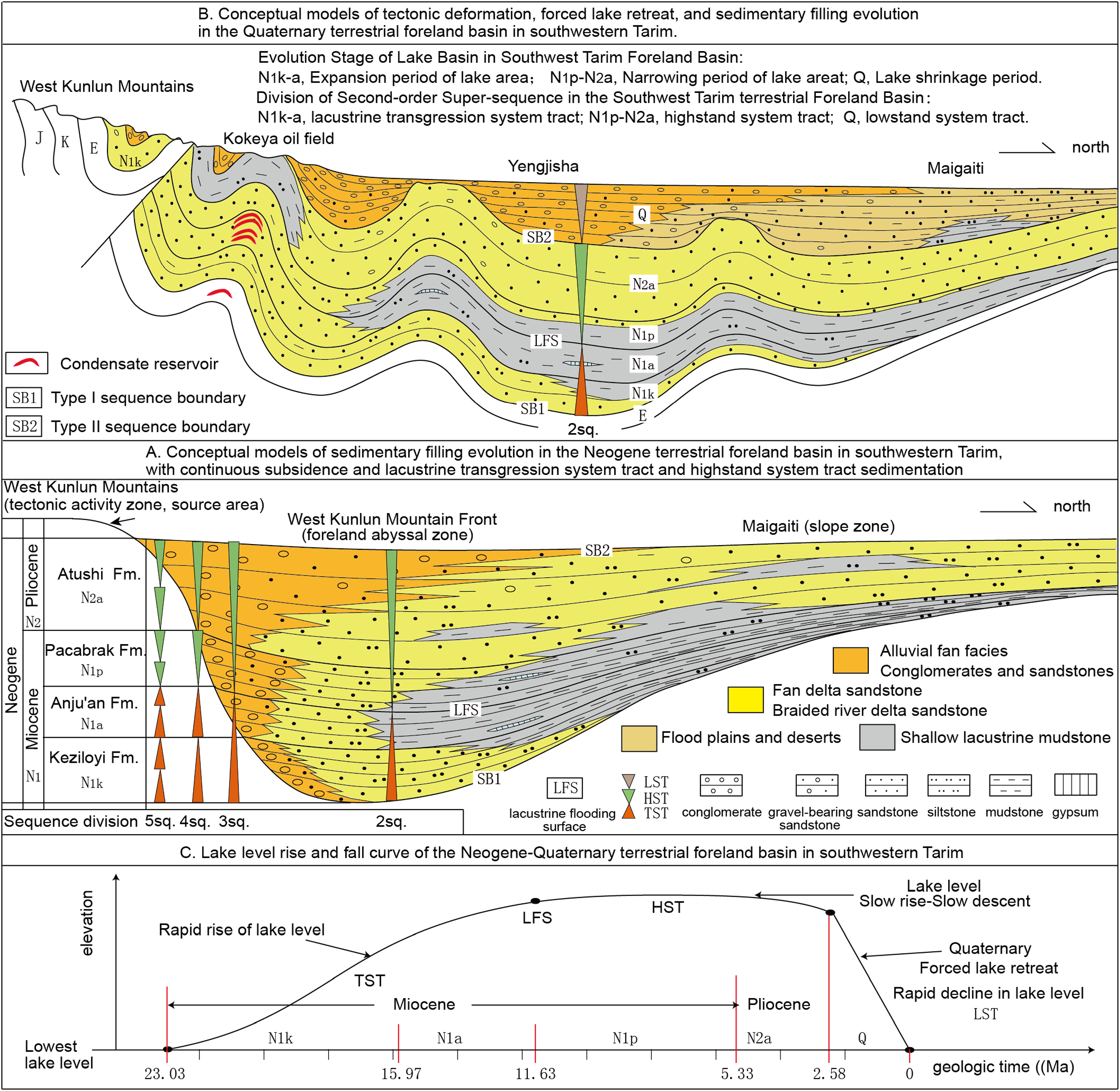
Conceptual model of type I sequence development in the Neogene–Quaternary terrestrial foreland basin in southwest Tarim.
Sedimentary evolution and sequence modeling of Neogene terrestrial foreland basin
The Neogene in Southwest Tarim was a stage of continuous subsidence and sedimentation in the terrestrial foreland basin, with sedimentary clastic strata up to 8000 m thick. However, from the perspective of sequence stratigraphy, its sedimentary evolution history is very simple. The Neogene can be summarized as a third-order cyclic sequence to illustrate its entire evolution history (Figure 7(a)).
During the early sedimentation stage of the Miocene Keziloyi Formation in the Neogene, the orogenic activity in the West Kunlun Mountains gradually increased, and sufficient material supply led to the well-developed alluvial fans and fan deltas in the foreland abyssal zone. However, during this period, the South Tianshan Mountains only formed a wide and gentle regional uplift to form a dam, forming a narrow foreland lake basin morphology in Southwest Tarim. The unconformity at the Neogene bottom in piedmont belt of the West Kunlun Mountains is sequentially covered by the sediments of the alluvial fan margin, fan delta plain-front, and shore-shallow lacustrine facies belts. In addition, as the lake area continued to expand, the sandbodies in fan delta facies of the Keziloyi Formation gradually occurred aggradation and retrogradation, forming a set of sedimentary sequences of the TST. The lacustrine mudstone strata are mainly distributed on the Maigaiti Slope.
During the sedimentation of the Miocene Anju’an Formation, the lake area further expanded, and the northern Kashgar and Sag-Qimugen Bulge was basically occupied by the lacustrine tract. During the late stage, the lake area expanded to its maximum, appearing the only LFS, and the relative lake level rose to the highest, forming a set of TST sedimentary sequences. Due to the influence of rivers entering the lake in the southern and southeastern parts of the Kekeya-Gt1 block of the Yecheng Sag, a set of fan delta system was deposited during the sedimentation of the Anju’an Formation, forming a set of aggradational fan delta front sandbodies.
During the early sedimentation period of the Miocene Pakabulak Formation, the lake area began to shrink, and many areas (such as the southern edge of the Yecheng Sag, the Qimeigan area, and the northern Kashgar area) developed accretion and progradation of sedimentary sandbodies in fan delta front facies into the lacustrine tract, forming a set of HST sedimentary sequences.
The sedimentation beginning of the Pliocene Atushi Formation marks the intensification of orogenic activity in the South Tianshan Mountains and West Kunlun Mountains. Especially, new provenance area began to form in the South Tianshan Mountains, with more abundant provenance supply, and significantly higher sedimentation rate than that of the Miocene, leading to large-scale separation of lacustrine tract and a decrease in the rise rate of relative lake level. The alluvial fan–fan delta-lacustrine system of the Miocene evolved into the alluvial fan-braided river delta-lacustrine system of the Pliocene. The piedmont alluvial fan, braided river delta conglomerate, and sandstone occurred large-scale aggradation and progradation to the basin, forming a typical HST sedimentary sequence.
LST sequence modeling of Quaternary terrestrial foreland basin
The terrestrial foreland basin in Southwest Tarim entered an LST sedimentary stage with tectonic deformation and forced lacustrine regression during the Quaternary and has continued to this day. Based on this, a conceptual model of sequence development and evolution can be established (Figure 7(b)).
The Southwest Tarim entered the stage of dividing the foreland basin in its late development stage during the Quaternary period. Under the intense influence of the late Himalayan tectonic movement, the basin suffered compression deformation, forming an alternating uplift-sag pattern of anticlines and synclines parallel to the orogenic belt. Due to the overthrust migration characteristics of the orogenic belt toward the basin, the Neogene strata near the sedimentary boundary of the basin were involved into the orogenic belt and almost eroded, and the Neogene basin may be shortened by a quarter. The current basin boundary is actually the boundary of the Quaternary orogenic belt, and there is a huge accumulation of Quaternary conglomerate strata in alluvial fan facies (molasse formation) in present piedmont belt.
The closer the anticline structure belt at the edge of the current basin is to the West Kunlun and South Tianshan orogenic belts, the more the top strata are eroded. For example, in the Kedong tectonic belt located on the southern edge of the Kekeya Sag, both the Pliocene Atushi Formation and the Miocene Pakabulak Formation are eroded, and the upper member of the Atushi Formation in the Kekeya tectonic belt is eroded. However, the Neogene in the Yingjisha tectonic belt, which is further away from the West Kunlun orogenic belt, is well preserved. The syncline zone between the piedmont anticlines deposited Quaternary conglomerate strata, which are in a continuous sedimentary relationship with the Neogene.
However, in the open areas of the synclines and the Maigaiti Slope, the Quaternary contacts with the underlying Neogene in conformable and continuous sedimentary relationship, which can be distinguished only based on seismic tracing, and the grain size and color of sediments. Due to the extremely arid climate, the lake level dropped sharply to the lowest point, and the lacustrine tract shrank or even disappeared. The depocenter of the basin migrated to the Maigaiti Slop, mainly composed of mudstone and fine sandstone sediments in wilderness and desert.
Establishment of a lake level fluctuation curve
After establishing a conceptual model of sedimentary development of the Neogene–Quaternary terrestrial foreland basin in Southwest Tarim, a lake level fluctuation curve model in terrestrial foreland basins can be established (Figure 7(c)). As a terrestrial lake basin was not affected by global sea level fluctuation factors, tectonic fluctuation basically controlled the initial formation, sedimentary evolution, and ultimate extinction of the terrestrial lake basin. This single-factor dominant condition provides convenient conditions for studying lake level fluctuation curve in a terrestrial basin, and the conclusions will also be closer to reality.
According to the analysis of the tectonic and sedimentary evolution stages of the Neogene–Quaternary terrestrial foreland basin in Southwest Tarim, the Miocene Keziloyi Formation-Anju'an Formation is a second-order super-sequence of a TST, representing a rapid upward cycle after the initial formation of the lake level in the terrestrial basin starting from 23.03 Ma ago. The lake area expanded to its maximum at 11.63 Ma ago, resulting in an LFS. The Miocene Pakabulak Formation and the Pliocene Atushi Formation are second-order super-sequences of an HST, representing a slow rising-slow falling cycle of lake level in the terrestrial basin that began at 11.63 Ma ago. The Quaternary is a second-order super-sequence of an LST, representing a rapid decline cycle of forced lacustrine regression in the terrestrial basin that began 2.58 Ma ago and continued to this day. The lake area extremely shrank and even dried up and desertified, and the lake level dropped to its lowest point.
It is obvious that the lake level fluctuation curve of a terrestrial basin is not a symmetrical sine curve, but a slightly more than half sine plus a straight-line segment with a large slope, representing the long-term stable tectonic subsidence and sedimentation period and short-term tectonic movement uplift-deformation period of the terrestrial basin. It also represents the three main change cycles (lake area expansion, lake area contraction and separation, and final extinction) after the initial formation of the terrestrial basin, as well as the corresponding system tracts.
Comparisons with classical development position of low system tract
The Neogene–Quaternary terrestrial foreland basin in Southwest Tarim is typical type I sequences. Theoretical research and case analysis show that above the basin-order unconformity at the bottom of the terrestrial basin, there is inevitably a process of lake water expanding from scratch. Therefore, the bottom must be a TST. The type I sequences of a terrestrial basin are composed of TST, HST, and LST. The LST was developed during the tectonic movement period at the top of the terrestrial basin. This obviously conflicts seriously with the theoretical model in classical sequence stratigraphy, which thinks that the LST of a marine passive continental margin basin are developed at the bottom of type I sequences. Therefore, it is necessary to theoretically explore and demonstrate the development position of the marine LST through practical examples.
Misplaced LST in classical sequence stratigraphy
In the conceptual model of classical sequence stratigraphy by Van Wagoner et al. in 1988, the bottom boundary of a sequence is defined at the inflection point of relative sea level decline. The LST is a product of the rapid sea level decline to initial rise period caused by forced regression, and is a prograding sedimentary body deposited in the bathyal-abyssal area. Type I sequences are composed of LST, TST, and HST, and LST is located at the bottom of the type I sequence.
It is controversial whether the bottom boundary of a basin-order sequence should be defined at the inflection point of relative sea level change or at the lowest sea level. Some scholars and the authors of this paper believe that it should be defined at the lowest sea level (Mei and Yang, 2000).
According to the sequence simulation evolution model of classical sequence stratigraphy, there are two possible ways for the unconformity bottom interface (SB1) of type I sequences at the basin order to extend toward the abyssal area. First, as the conceptual model of classic sequence stratigraphy, it extends from the bottom conformity of the LST, the LST is classified as a new sequence (the earliest sequence). Second, it extends from the top unconformity of the LST, the LST is classified as an old sequence (the latest sequence).
This article believes that the theoretical model is a problematic one. The meaning of “forced regression” can be understood as the transition of tectonic plates from a long-term period of stable decline to a period of collision and tectonic uplift. Shallow seas are uplifted to be land, forming an eroded land unconformity. The passive decline in relative sea level causes forced regression, and the coastline retreats near the slope break of the continental shelf. The upper strata of the newly deposited HST and older strata are eroded, and the eroded debris is transported to the abyssal area with huge accommodation for super-compensation sedimentation, resulting in the formation of LST. Therefore, the formation time, process, and concept of the LST are correct. The problem is that as forced regression continues, relative sea level continues to decline, the top LST in this model (especially the top lowstand wedge) will also expose to sea level and form a land unconformity. Therefore, the basin-order erosion unconformity should pass through the top LST, and the LST should be classified as the old sequence (the latest sequence). The order of the system tracts of type I sequences in marine passive continental margin should be modified to be the TST, HST, and LST. In this way, the superimposed orders of type I sequence system tracts in marine and terrestrial basins are consistent, and the LST are both developed at the top of the prototype sedimentary basin.
Example of marine low system tract
The eastern part of the Tarim Basin developed typical depositional sequences of LST in an abyssal basin during the late sedimentation of the Ordovician.
The Precambrian Cambrian Ordovician is the first prototype sedimentary basin of the Tarim Paleozoic three stage superimposed basin (Zhang et al., 2015). During Ordovician, it inherited the sedimentary pattern of the Cambrian period, and remained a platform-basin alternating sedimentary pattern (He et al., 2017). From west to east, there existed the Tarim Platform, Tadong (East Tarim) Basin, and Luoxi Platform. The Tadong Abyssal Basin was located between two carbonate platforms, with a width of over 300 km.
The eastern Tarim Basin has been covered by 3D and 2D seismic survey lines. The Ordovician system is drilled in both the platform and the basin regions. The Ordovician surface profile of the Tadong Abyssal Basin has been measured and studied in detail for stratification by paleontological data, and three rounds of lithofacies paleogeographic mapping have been conducted (He et al., 2017; Lin et al., 2012; Zhang et al., 2007; Zheng et al., 2022). On this basis, this article established a model for the development and evolution of the Ordovician sequence stratigraphy in eastern Tarim Basin (Figure 8).
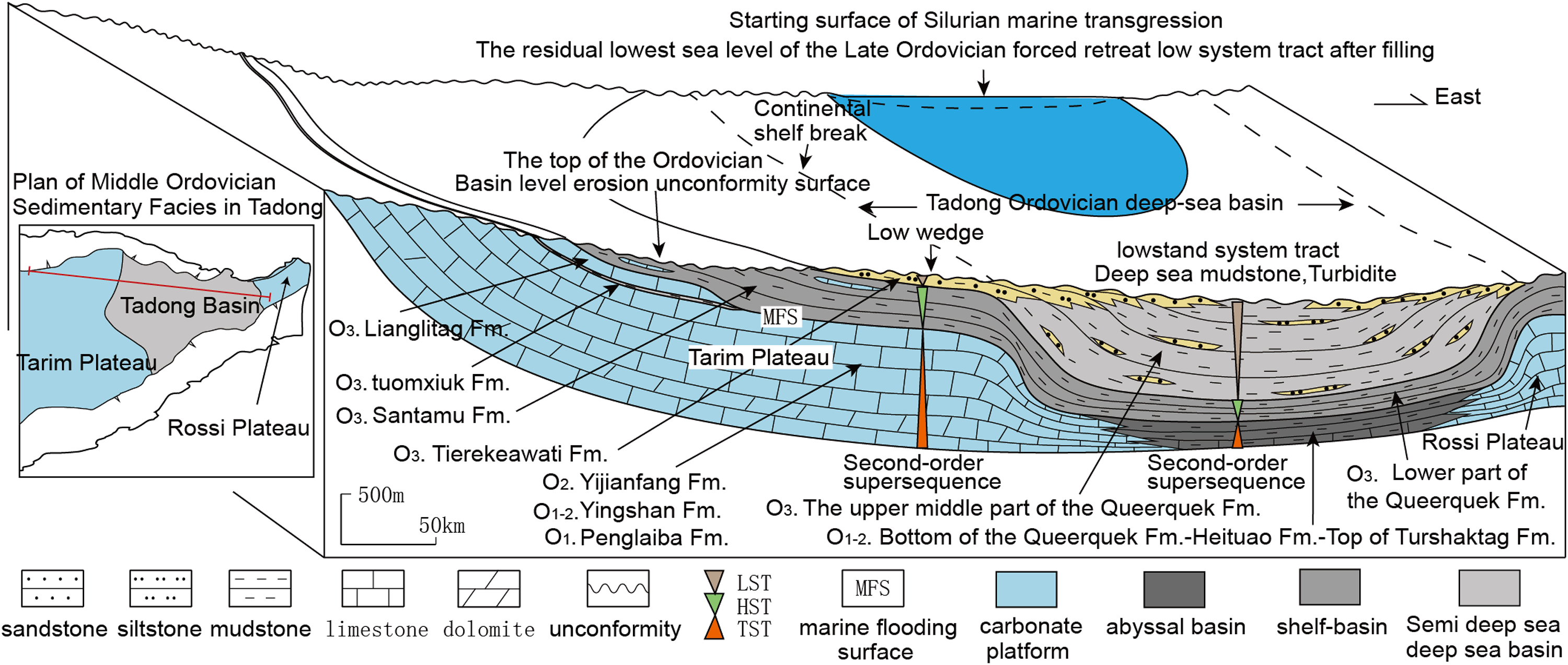
Conceptual model for developing lowstand system tracts of deep sea basins in the eastern Tarim Basin in late Ordovician.
The Ordovician in the Tadong region can be clearly divided into three sedimentary periods.
Period I: It was a period of stable tectonic subsidence of the Tarim Plate during the Early-Middle Ordovician, during which the relative sea level continued to rise and the sea area continued to expand, resulting in the continuous deposition of 1200–1500 m of shallow marine carbonate rocks from the Penglaiba Formation, Yingshan Formation, and Yijianfang Formation of the Middle-Lower Ordovician in the Tadong Platform and its margin facies zones (Peng et al., 2022). The top of the Yijianfang Formation of the Middle Ordovician is the MFS. During the same period, only about 400 m of gray-black marl and mudstone layers were deposited at the top of the Middle-Lower Ordovician Turshaktag Formation, the Heituao Formation, and the bottom of the Queerquek Formation in the Tadong abyssal basin, which is a typical abyssal under-compensated condensed section strata. From platform to abyssal basin, the Middle-Lower Ordovician can be divided into the second-order super-sequence of a TST. Period II: It was the early-middle period of the Late Ordovician, which was still a period of stable tectonic subsidence (Gao et al., 2017). Although the relative sea level continued to rise, the sea area was shrinking. The mudstone strata at the front of the HST originating from unknown land were deposited on the Tarim Platform and inside the Tadong Abyssal Basin, separating the Tarim Platform into two isolated platforms of the Upper Ordovician Lianglitag Formation, namely the Tabei and Tazhong platforms, and gradually “submerged” from near to far regions, depositing dark-gray mixed shelf mudstone interbedded with limestone in the Upper Ordovician Sangtamu Formation for about 700 m thick, and dark-gray mudstone in abyssal facies interbedded with turbidite of the same thickness was deposited in the lower part of the Queerquek Formation in the abyssal basin, forming the second-order super-sequence of HST from the shelf to the basin. Period III: It was the late stage of the Late Ordovician, when the Tarim Plate transitioned from a period of stable tectonic decline to a period of tectonic uplift, and entered a stage of forced regression (Liu et al., 2022). Under tectonic stress compression, the Tarim Platform and diamictic shelf region were uplifted and deformed as a whole, forming two land uplifts (Tabei and Tazhong). The Sangtamu Formation suffered strong erosion, and even the Middle-Lower Ordovician carbonate strata in Tabei region were eroded and exposed to the surface, forming karst landforms. The relative sea level was forced to passively decline, and the coastline retreated to the slope break margin of the shelf in the Tadong Abyssal Basin. The eroded debris was deposited in the abyssal basin with huge accommodation in prograding style, forming abyssal mudstone interbedded with turbidite strata in the LST with a thickness of over 2000 m in the middle-upper part of the overcompensated Queerquek Formation. The top was delta deposit in transitional facies. However, in the local low-lying areas at the edge of the shelf facies, interbedded sandstones and mudstones were deposited in delta facies with a thickness of about 300 m in the Upper Ordovician Tierekeawati Formation, forming lowstand wedges. The Ordovician top of the Tarim Basin is a basin-order eroded unconformity, which is covered by the TST sedimentary strata at the Silurian bottom, starting a new round of transgressive-highstand cycle sedimentation in the prototype sedimentary basin.
Similarities and differences of LST between Ordovician in East Tarim and Quaternary in Southwest Tarim
The prerequisite for the appearance of the LST in the late Ordovician abyssal basin in East Tarim is consistent with that in the top Quaternary of the continental foreland basin in Southwest Tarim. For example, they both underwent a long period of stable tectonic subsidence and sedimentation before transitioning into a period of tectonic uplift activity; they both experienced enhanced compressive stress leading to deformation of the early strata and structures; they both occurred forced sea (lacustrine) regression, leading to relative sea/lake level decline; they both occurred strong erosion caused by the uplift of the basin margin into land, and continuous sedimentation in the basin center.
The difference lies in the fact that marine LST generally appear in abyssal basins, mainly composed of abyssal mudstone sediments interbedded with turbidite siltstones and fine sandstones, while the LST in a terrestrial lake basin generally appear in piedmont land and shrinking shallow lake areas, mainly composed of coarse clastic rocks (such as alluvial fan conglomerate, braided river delta conglomerates, and sandstones) interbedded with mudstones.
Conclusions
(1). During the Miocene period, alluvial fan facies, fan delta facies, and lacustrine facies were developed sequentially from the piedmont belt of the West Kunlun Mountains to the Maigaiti Slope. During the sedimentation of the Miocene Anju’an Formation, a huge shallow lake with fresh water and brackish water appeared, characterized by gray green, gray, and reddish-brown mudstone interbedded with thin gypsum sediments.
(2). A prototype basin five-order sequence division scheme and division principles have been established. The Neogene-Quaternary terrestrial foreland basin in Southwest Tarim is a first-order mega-sequence (type I sequence) with a sedimentation date of 23.03 Ma and a sedimentation thickness greater than 10,000 m. Internally, it can be divided into three second-order super-sequences, with the LFS appearing in the late sedimentary period of the Neogene Anju’an Formation as the boundary: the lower part is a second-order super-sequence of the TST, the upper part is a second-order super-sequence of the HST, and the top Quaternary is a sedimentary sequence of the LST formed by forced lacustrine regression.
(3). According to the stages of tectonic-sedimentary evolution, the Neogene–Quaternary terrestrial foreland basin in Southwest Tarim can be divided into two stages of evolution. The Neogene foreland basin was at a stable tectonic subsidence sedimentary stage, while the Quaternary was at a stage of tectonic deformation, forced lacustrine regression, edge uplift and erosion, and central subsidence and deposition of the foreland basin. Therefore, according to the two stages of a prototype sedimentary basin, the conceptual models of the sedimentary evolution of strata and sequence stratigraphy were established separately.
(4). The study shows that the classical sequence stratigraphy made a significant mistake in establishing the theoretical model of type I sequences, as it placed the LST in the wrong position. The superimposed order of the system tracts in corrected type I sequences is TST, HST, and LST successively.
(5). Finally, two prototype sedimentary basin examples were utilized to demonstrate the development location of the LST. They indicate that LST in both marine and terrestrial prototype sedimentary basins were developed during the late tectonic activity period of the basin, being the topmost system tract in the prototype sedimentary basin.
Footnotes
Declaration of conflicting interests
The authors declared no potential conflicts of interest with respect to the research, authorship, and/or publication of this article.
Funding
The authors received no financial support for the research, authorship, and/or publication of this article.