
Abstract
The East African Rift System (EARS) is the youngest rift with the eastern and western branches, consisting of multiple secondary rifts. It is generally characterized by low extent of exploration and great exploration potential. Identifying the differences in hydrocarbon accumulation conditions in various rifts is very important in providing guidance for hydrocarbon exploration and selecting favorable exploration targets in this area. Based on the interpretation of first-hand seismic-geological data, and combining other materials such as commercial databases and open access literature, the structural characteristics of the main rifts in the eastern and western branches of the EARS are comparatively analyzed; based on the anatomy of the discovered hydrocarbon reservoirs, the rifts of the EARS are classified into four types depending on their structural styles, including double-fault type, simple single-fault type, single-fault transfer type, and single-fault terrace type, and the control of structural style over hydrocarbon accumulation in the EARS is discussed. In the Western Branch of the EARS, large rifts such as the Albertine Rift and the Tanganyika Rift are mainly of double-fault type and single-fault transfer type, and only some small rifts are of the simple single-fault type. The rifts in the Eastern Branch of the EARS are generally small; the rifts in the northern section of the Western Branch are mainly of the simple single-fault type, and those in the southern section are mainly of the single-fault terrace type. The hydrocarbon potential of double-fault rifts is the greatest, followed by that of simple single-fault rifts and single-fault transfer rifts, and the hydrocarbon potential of single-fault terrace rifts is relatively limited. The results obtained from a comparative analysis of the structures, sediment fills, and reservoir elements of various rifts show that the west side of the Albertine Rift, the southeast of the Tanganyika Rift, the Kerio Rift, and the land in the northwest of the Turkana Rift have great exploration potential.
Keywords
Introduction
Among the six major types of basins, rift basins are very important hydrocarbon-bearing basins where the oil and gas resources are second only to those in foreland basins and passive margin basins, and they are the most active areas of hydrocarbon exploration in the world (Dou and Wen, 2021; Dou et al., 2011; Fraser et al., 2007; Wen et al., 2012a, 2014; Yu et al., 2010; Zhang et al., 2018, 2020). The East African Rift System (EARS), which is located in the East Africa, is currently the youngest group of Cenozoic intracontinental rift basins in the world. It consists of two nearly parallel branches, namely, the Eastern Branch and the Western Branch, and it is still in the early rifting stage (Wen et al., 2012b).
In 2006 and 2012, Tullow made significant breakthroughs in hydrocarbon exploration in the Albertine Rift in the Western Branch of the EARS and the South Lokichar Rift in the Eastern Branch, proving the great exploration potential of this area (Wen et al., 2012b; Zhang et al., 2020). The data in the IHS database shows that, as of now, there are 14 oilfields in the South Lokichar Rift (in the Eastern Branch of the EARS) in Kenya, with total 2P reserves of 888 MMboe (2P reserves are the sum of proven reserves and probable reserves, which represent the best estimate of reserves), all of which are operated by Tullow. Eighteen oilfields have been discovered in the Albertine Rift (in the Western Branch of the EARS), with total 2P reserves of 1730.1 MMboe. In 2010, CNOOC and Total became Tullow's partners in the Albertine Rift Block. In September 2013, CNOOC became the operator of the Kingfisher Oilfield and obtained an oilfield development license from the Ugandan government. In addition, CNOOC also holds partial interests in 12 oilfields.
As a typical intracontinental rift, the EARS has attracted extensive attention from domestic and foreign scholars. In the 1890s, Gregory (1894), a British scholar, introduced the concept of “Rift” into the study of the East African Rift. Subsequently, foreign scholars conducted studies on the formation and evolution of the EARS, the structural characteristics of the eastern and western branches of the EARS, the types of transfer zones and their effects on hydrocarbon accumulation, the relationship between the formation of the EARS and the mantle plume, the distribution of turbidites in the Western Branch of the EARS, the thermochronology of the North Lokichar Rift, the evaluation of source rocks in the Turkana Rift, the lithofacies and paleogeography of the Tanganyika Rift, and the petrophysical properties of reservoirs in the Albertine Rift (Boone et al., 2018; Chorowicz, 2005; Ebinger, 1989; Furman, 2007; Lærdal and Talbot, 2002; Macgregor, 2015; Morley, 1989; Oppo and Hurst, 2018; Pik et al., 2006; Rogers et al., 2000; Schneider et al., 2016; Scholz et al., 2020; Shaban et al., 2021a; Simon et al., 2017; Talbot et al., 2004; Tumushabe et al., 2022, Wills, 1937; Zhang and Scholz, 2015). Compared with these studies conducted by foreign scholars, the domestic research on the EARS started at a later time. In 2001, Zhang X and Tong XG evaluated the hydrocarbon potential of the Albertine Rift basin in the Western Branch of the EARS. Then, as major oil and gas discoveries were made in the Albertine Rift and Chinese oil companies acquired a certain number of exploration blocks in the rift, the Albertine Rift basin continuously attracted the attention of domestic scholars. Domestic scholars have studied the geological characteristics of petroleum systems in the Albertine Rift, the distribution of sedimentary systems and sandstone bodies in the northern part of the Albertine Rift, the impact of volcanic activity on hydrocarbon accumulation in the EARS, the fault and sedimentary systems of the Albertine Rift, the tectonic evolution of the Eastern Branch of the EARS, the styles of hydrocarbon accumulation in the South Lokichar Rift, the main factors controlling hydrocarbon accumulation, and the exploration potential of various rifts in the Eastern Branch of the EARS (Cui et al., 2018; Guo et al., 2019; Han and Zhao, 2018; Jia et al., 2018, 2021, 2022; Wang et al., 2021; Wen et al., 2012b; Yang et al., 2015; Zhang et al., 2017).
Scholars and oil companies at home and abroad have studied the tectonic evolution, lithofacies, paleogeography, and hydrocarbon accumulation characteristics of the EARS to some extent, and some oil and gas discoveries have been made in the South Lokichar Rift in the Eastern Branch of the EARS and the Albertine Rift in the Western Branch of the EARS. However, the ongoing exploration activities are geographically concentrated in Uganda and Kenya, and there are few exploratory wells drilled in other regions. In the EARS, there are still more than five rifts that have not been explored, each with an area of more than 16,000 m2, and the total area covered by these rifts is nearly 150,000 m2. Therefore, the extent of exploration of the EARS is still very low. The rifts in the EARS have different structural styles, the geological conditions for hydrocarbon accumulation vary from one type of rift to another, and the modes of hydrocarbon accumulation in various rifts are still unclear. For these reasons, it is necessary to summarize the structural styles of the main rifts in the EARS in order to determine the direction of hydrocarbon exploration for rift basins that have been explored to relatively low extents. In this paper, based on the results and understandings from previous studies, commercial databases, and the interpretation and study of seismic-geological data, the structures of the main basins in the eastern and western branches of the EARS are comparatively analyzed, and the hydrocarbon accumulation models of various rifts of the EARS are established based on the anatomy of the discovered oil and gas reservoirs. In addition, the favorable petroleum plays in the EARS and the direction of subsequent hydrocarbon exploration are investigated by means of comparative research with a view to providing the basis for evaluating the exploration potential of the EARS and selecting favorable target zones in advance.
Regional geological setting
The EARS is a group of Cenozoic intracontinental rift basins located on the eastern continent of the African Plate, with a total length of about 3000 km, a total width ranging between 50 and 150 km, and a total area of about 2.2 × 10⁵ km2 (Bosworth et al., 2005; Wen et al., 2012b). In terms of planar distribution, the EARS consists of a series of mutually independent, adjacent rift valleys with a total length of thousands of kilometers, and each rift is controlled by fault(s) and is nearly 100 km long and tens of kilometers wide (Figure 1). The EARS is situated south of the Red Sea and the Gulf of Aden, east of the stable Nubian Landmass and the Congo Craton, and west of the East African passive continental margin. The Tanzania Craton is located between the eastern and western branches of the EARS. The EARS, the Red Sea, and the Gulf of Aden form a trifurcate rift system with the Afar hotspot as its center (Berhe, 1986; Cui et al., 2018; Hackman et al., 1990; Hoffman et al., 1997; Jia et al., 2021; Macgregor, 2015; Woldegabriel et al., 1990).
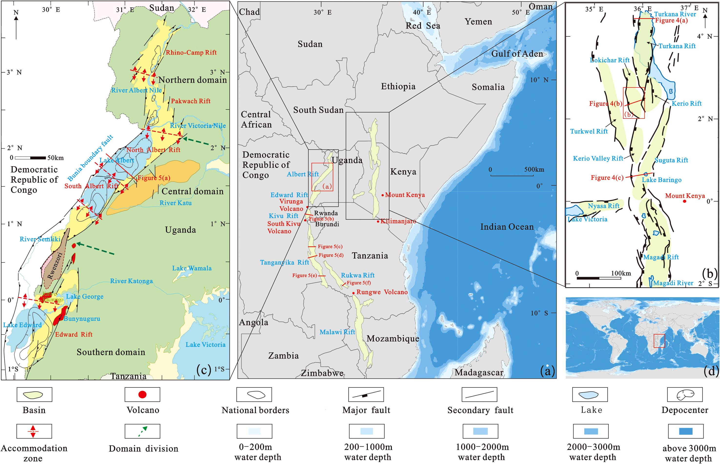
Overview of the East African Rift System, (a) location of the East African Rift System, (b) location of the Eastern Branch of the East African Rift System, (c) location of the Albertine Rift, (d) global map (modified from Abeinomugisha and Kasande, 2012).
The Eastern Branch of the EARS extends southward from the Afar hotspot to the Ethiopian Rift Valley and the Kenyan Rift Valley. Along this branch, the volcanic activity is strong, creating volcanic mountains, and shallow lakes have formed locally. The main rifts in this branch include the Turkana Rift, the North Lokichar Rift, the South Lokichar Rift, the Kerio Rift, the Kerio Valley, the Suguta Valley, and the Magadi Rift (Nutz et al., 2020; Wang et al., 2021). In the Western Branch of the EARS, the level of development of volcanic rocks is low; the main volcanoes, such as the Virunga, South Kivu, and Rungwe volcanoes, have formed between rifts (James et al., 2019; Kiram et al., 2002; Zhang and Tong, 2001); and a series of rifts dominated by deep lakes, such as the Albertine Rift, the Edward Rift, the Kivu Rift, the Tanganyika Rift, the Rukwa Rift, and the Malawi Rift, have formed from north to south (Figures 1 and 2).
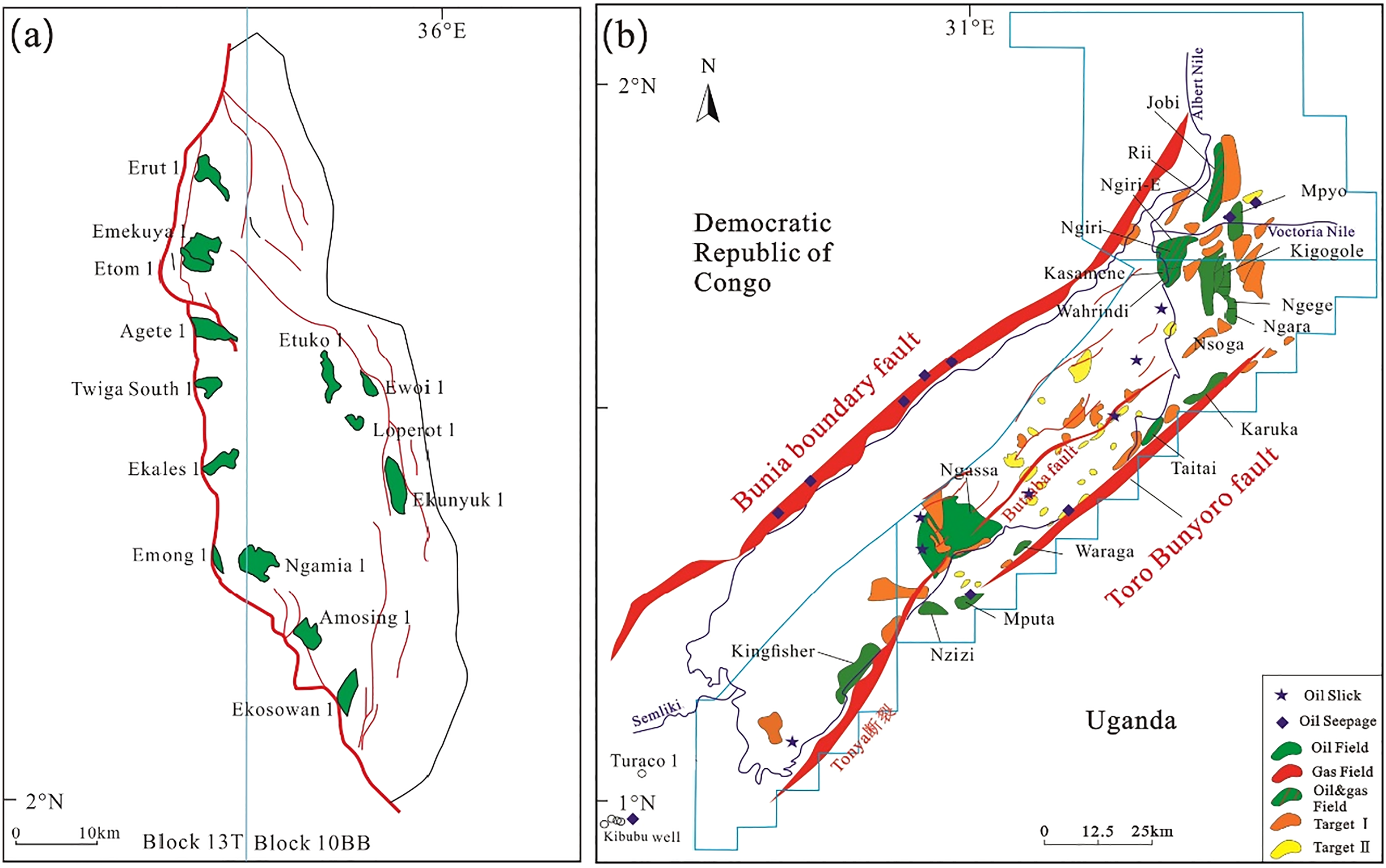
Distribution of oil and gas fields in the South Lokichar Rift in the Eastern Branch of the EARS (a) and the Albertine Rift in the Eestern Branch of the EARS (b). See Figure 1 for the specific locations.
The rifts in East Africa mostly formed during the Karoo, the Cretaceous, and the Cenozoic. These rifts are referred to as Karoo (Late Carboniferous-Triassic) rifts, Cretaceous rifts, and Cenozoic rifts, respectively. During the period from the Carboniferous to the Triassic, the African continent experienced strong tectonic compression and rifting (Chorowica, 1990). Since the Late Carboniferous, under the control of Karoo mantle plume activities, rifting had occurred in multiple places in Gondwana, and Karoo basins had developed extensively in South and Central Africa (Cairncross, 2001; Catuneanu et al., 2005; Morley et al., 1992). These Karoo basins are mainly distributed along the Precambrian tectonically active zone and the Mwembeshi Shear Zone (Figure 3(a)). Under the control of the dextral strike-slip of the Ubendian Belt in the south-central part of East Africa, rifting occurred in the Tanganyika-Rukwa-Malawi rift segment of the Western Branch of the EARS (Figure 3(a)) during the Karoo period, forming the pre-existing structure of the EARS (Delvaux et al., 2012; Kreuser, 1991).
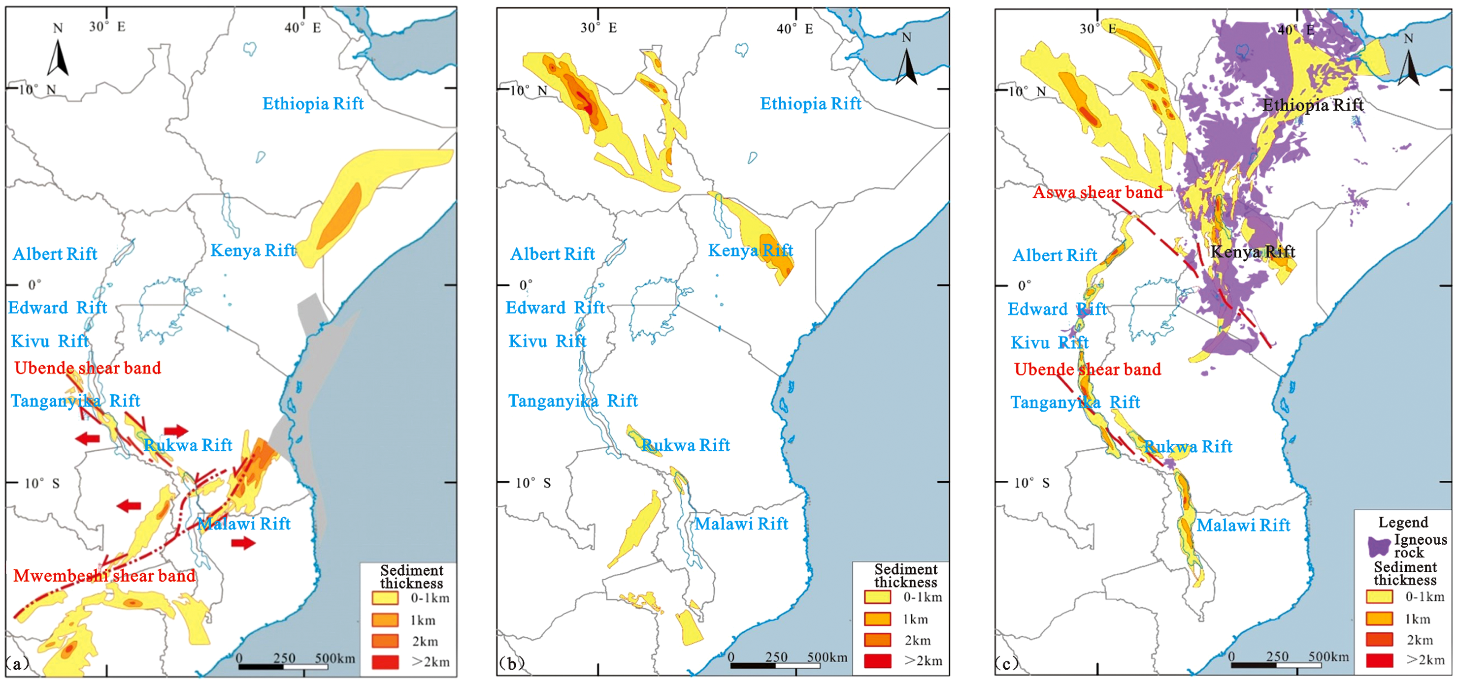
Distributions and sediment thicknesses of (a) Karoo rifts, (b) Cretaceous rifts, and (c) Cenozoic rifts in East Africa.
During the Mesozoic Era, with the separation of Madagascar from the African Plate, the early faults in the Rukwa Rift in the Western Branch of the EARS were reactivated under the strike-slip stress in the east of the African Plate, and Cretaceous rift sequences were formed (Figure 3(b)), but the distribution range of these sequences was relatively limited. According to the currently available geological data, the Cretaceous rifting mainly occurred in the Rukwa Rift (Morley et al., 1992; Peirce and Lipkov, 1988).
The Cenozoic Era is the main period for the development of the EARS since the Oligocene. During this period, affected by the activities of the Afar mantle plume, the African and Arabian plates separated from each other, and the Red Sea-Gulf of Aden-East African Rift (EAR) trifurcate rift system began to form (Agostini et al., 2011; Corti, 2009; Ebinger et al., 2000; George and Rogers, 1998). In general, magnesium-silicate rocks occurred in the Red Sea and the Gulf of Aden, and the Red Sea and the Gulf of Aden were in the intercontinental rifting stage corresponding to the juvenile stage of the Wilson Cycle, while the EAR was still in the intracontinental rifting stage corresponding to the embryonic stage of the Wilson Cycle (Bosworth et al., 2005). During the Cenozoic Era, rifting was accompanied by extensive magmatic activity, the volcanic activity in the Eastern Branch of the EARS was strong and widespread, while the volcanic activity in the Western Branch of the EARS was weak and limited to some areas. The effect of rifting was transferred from north to south, and rifting first occurred in Ethiopia and Kenya along the Eastern Branch. In the late Miocene, under the control of the Tanzania Craton and the Aswa Shear Zone, the effect of rifting was transferred to the Albertine Rift in the Western Branch and then transferred southward to the Edward rift, the Kivu Rift, the Tanganyika Rift, the Rukwa Rift, and the Malawi Rift. The Eastern Branch of the EARS extended southward to northern Tanzania. Generally, the rifting in the eastern and western branches of the EARS gradually weakened from north to south (Figure 3(c)) (Jin et al., 2012; Lin et al., 2005).
Data and methods
The study area includes the entire EARS. The data used for this study includes the 3D seismic data of the South Lokicha Rift covering an area of 950 km2; 101 of 2D seismic data from the southeastern part of the Tanganyika Rift (collected in 2010), with grid density of 3.5 × 10 m, involving a total length of 2084 km and a total area of 7710 km2; 149 of 2D seismic data from the northern Turkana Rift, with grid density of 4.5 × 5 m, involving a total length of 3642.5 km and a total area of 21,000 km2; and the seismic-geological sections of various rifts in the Albertine Rift involving a total length of 3200 km. In addition, the commercial databases provided by S&P Global and Rystad, the public information disclosed by oil companies, and first-hand data such as well logs, core analysis data, and thin-section analysis data are also used in this study.
Based on first-hand seismic-geological data of the EARS, commercial databases, and public information, the structures of the main rifts of the eastern and western branches of the EARS were compared, the differences in structural style and sediment fill between the eastern and western branches of the EARS were identified, the hydrocarbon accumulation conditions of different rifts where oil fields have been discovered (the Albertine Rift of the Western Branch and the South Lokichar Rift of the Eastern Branch) were systematically compared, the control of structural style over hydrocarbon accumulation in the EARS was discussed, and the exploration potential of other rifts without oil and gas discoveries in the EARS was analyzed in order to determine the future exploration direction.
Differences in structural style between rifts in the eastern and western branches
Structural characteristics of the main rifts in the Eastern Branch
The Eastern Branch of the EARS is greatly affected by the Afar mantle plume and is subject to frequent magmatic activities. The rifts along this branch formed early, and Oligocene sedimentary strata were formed (Tiercelin et al., 2004; Wang et al., 2021). However, these rifts are relatively small in size. Large rifts include the Turkana Rift, the Lokichar Rift, and the Kerio Rift (Figure 1(a) and (b)), all of which are half-grabens.
The Turkana Rift is located in the northernmost part of the Eastern Branch of the EARS and consists of a series of half-grabens distributed in a staggered pattern. One side of the rift is controlled by a boundary fault, and the other side overlaps the Precambrian crystalline basement. In this rift, secondary faults are relatively well-developed, forming a series of synthetic and antithetic fault blocks (Figure 4(a)).
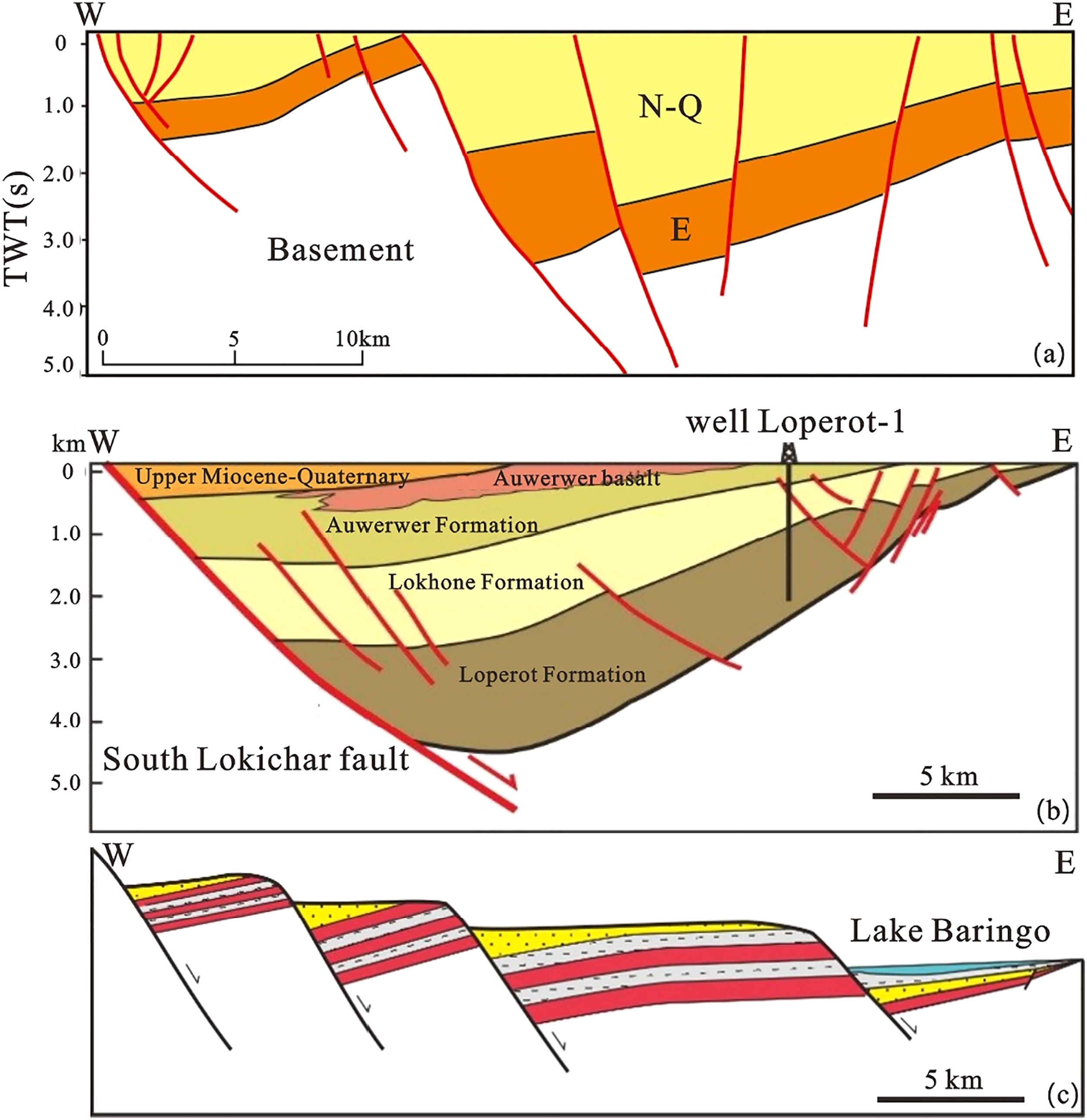
Structural cross-section of the Eastern Branch of the EARS, (a) geological section of the Turkana Rift, (b) geological section of the South Lokichar Rift, (c) geological section of southern part of the Eastern Branch of the EARS. See Figure 1(b) for the specific location.
It can be seen from Figure 4(b) that the South Lokichar Rift is a typical Cenozoic intracontinental rift basin with the structural characteristics of faulting in the west and onlap in the east, and its western boundary is controlled by the South Lokichar Fault. In terms of planar shape, the South Lokichar Rift is a spindle-shaped structure with a nearly south–north trend, with a steep slope zone in the west and a gentle slope zone in the east (Figure 2(a)). The results of the interpretation of the east–west seismic-geological section of the South Lokichar Rift and the measurement of the dip angle of the fault show that the dip angle of the South Lokichar Fault ranges between 30° and 45°, there are a series of secondary faults distributed along this boundary fault, forming rollover anticlines and nose-shaped structures, and nearly parallel synthetic or antithetic fault blocks are well-developed in the eastern gentle slope zone of the South Lokichar Rift (Figure 4(b)).
The southern part of the Eastern Branch of the EARS is greatly affected by volcanism, and the scales of the rifts in this part are small. On the cross-section, the developed rifts are mainly shown as small fault terraces arranged in parallel from west to east (Figure 4(c)).
Structural characteristics of the main rifts in the Western Branch
Due to different tectonic environments and geodynamic backgrounds, the rifts in the Western Branch of the EARS have different structural characteristics. Most of these rifts are double-fault grabens, and due to the influence of accommodation zones and pre-existing structures, half-grabens have also developed locally in the Western Branch (Guo et al., 2019; Tiercelin et al., 2012; Wen et al., 2012b).
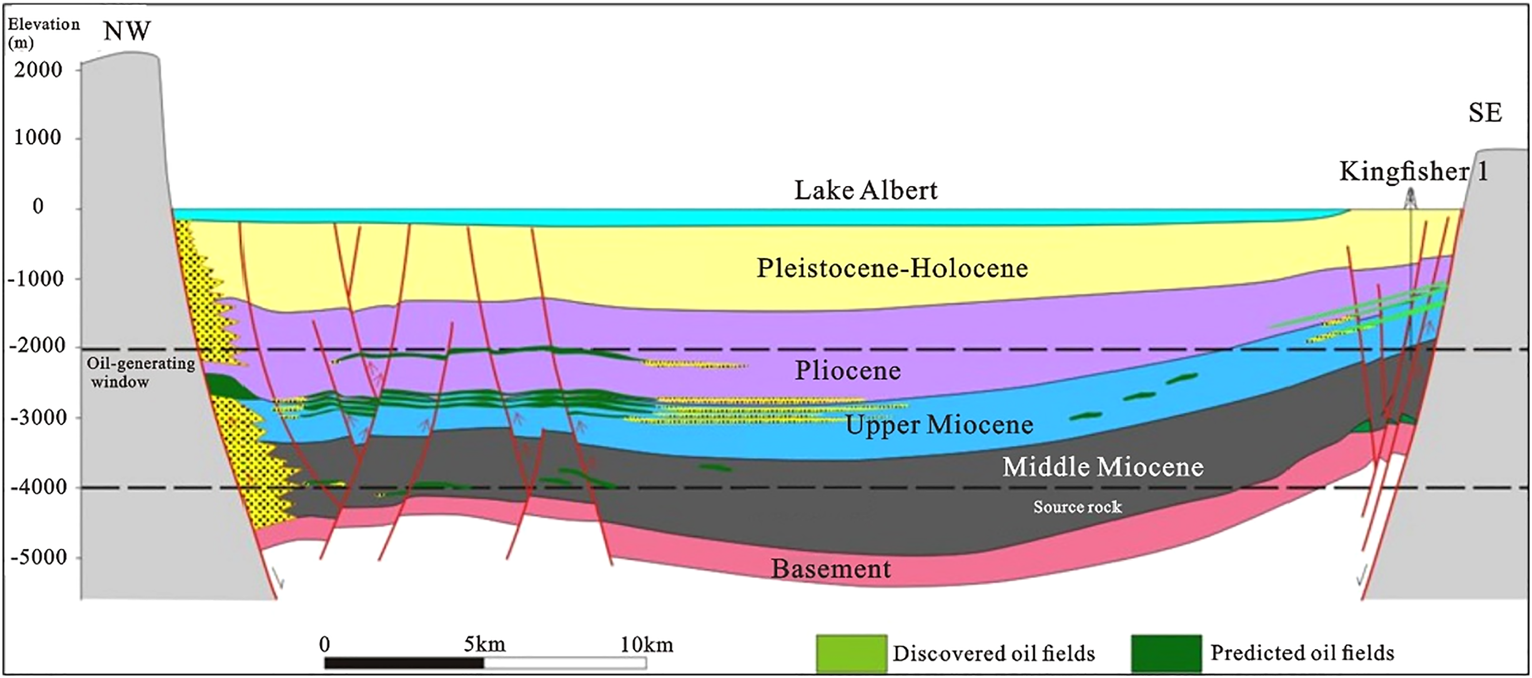
The Albertine Rift is located at the northern end of the Western Branch of the EARS, and the main faults in the rift mostly trend from northeast (NE) to southwest (SW). This rift is a graben structure with two depocenters, namely, the North Albertine depocenter and the South Albertine depocenter. The two sides of the rift are controlled by high-angle boundary faults, and strike-slip faults have been formed between the southern and northern depocenters under the effect of strike-slip faulting (Figure 5(a)).
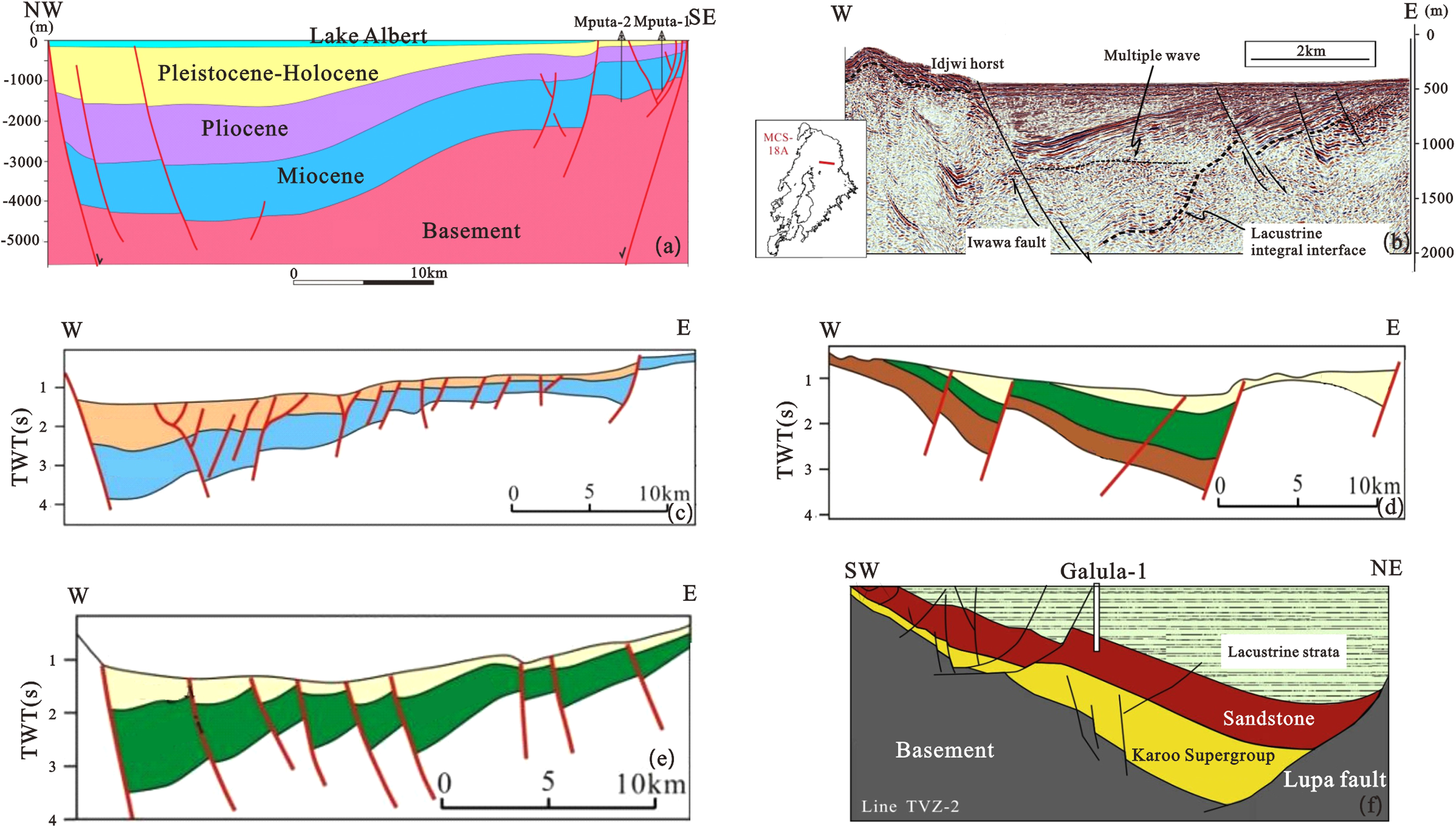
Seismic-structural cross-section of the basin in the Western Branch of the EARS, (a) geological section of the Albertine Rift, (b) seismic section of the Kivu Rift, (c) (d) (e) geological section of the Tanganyika Rift, (f) geological section of the Rukwa Rift (modified from Burgess et al., 1985; Roberts et al., 2010; Wood et al., 2015). See Figure 1 for the specific location.
Volcanoes have formed widely around the Kivu Rift. This rift is small in scale and has only been studied to a small extent (Wood and Scholz, 2017; Zhang and Scholz, 2015). The west side of the rift is controlled by the West Kivu boundary fault, and a series of secondary faults have developed eastward, creating several half-grabens (Figure 5(b)).
The Tanganyika Rift is located in the middle of the Western Branch of the EARS and mainly consists of a series of half-grabens (Shaban et al., 2021b). Due to the complex tectonic environment, the shapes and combinations of these half-grabens are different (Figure 5(c) to (e)). As shown in the cross-section, the axis of the half-graben in the northern part of the Tanganyika Rift is shaped like an anticline (Figure 5(c)) (Kiram et al., 2002). The faults within the half-graben in the middle of the Tanganyika Rift are highly developed, and the half-graben is controlled by a series of westward-dipping accommodation faults that create multiple parallel fault blocks dipping in the same direction. It can be seen from Figure 5(d) that the east side of this half-graben is controlled by a main fault, and the secondary faults in this half-graben are well-developed, highly active, high-angle faults with large throws (the throw of these fault systems can be as much as 6 km) and independent depocenters, indicating that faulting has significant control over depositional processes. In comparison, the secondary faults in the southern part of the Tanganyika Rift are more developed. These secondary faults are parallel to each other, and local depocenters have been formed (Figure 5(e)). In addition, it is possible that the pre-existing structures of Karoo rifts have developed in the lower part of the Tanganyika Rift, thus forming superimposed rift basins.
The Rukwa Rift is situated between the Tanganyika Rift and the Malawi Rift, which is the main area controlled by the Ubendian Belt. Moreover, it is located northwest of the Rungwe Volcanic Province. This rift is different from other rifts in terms of the mechanical mechanism governing the development of rifts. Therefore, its structural characteristics are greatly different from those of other rifts. The east side of the rift is controlled by the NW-SE trending Lupa boundary fault. This boundary fault dips gently southwest at an angle of about 30–45°, cutting through the Precambrian basement (Burgess et al., 1985; Morley et al., 1992). The basin is a half-graben, and secondary faults are relatively well-developed in the gentle slope zone on the west side, creating a series of synthetic or antithetic fault blocks (Figure 5(f)). The drilling data of wells Galula-1 and Ivuna-1 shows that there are three well-developed sequences in the Rukwa Rift, namely, the Karoo Supergroup, the red sandstone sequence, and the Tertiary lacustrine sequence, indicating that the Rukwa Rift experienced rifting as early as the Karoo period (Roberts et al., 2004, 2010; Wescott et al., 1991). Among the rifts in the Western Branch of the EARS, the Rukwa Rift is the only rift in which the development of the Karoo sequence has been confirmed by drilling data.
Structural styles of various rifts in the EARS
Based on the seismic interpretation of rifts and the analysis of the characteristics of rift development, the forms of fault combinations, and the characteristics of transfer zones, the rifts of the EARS can be classified into four types depending on their structural styles, namely, double-fault type, simple single-fault type, single-fault transfer type, and single-fault terrace type (Figure 6).
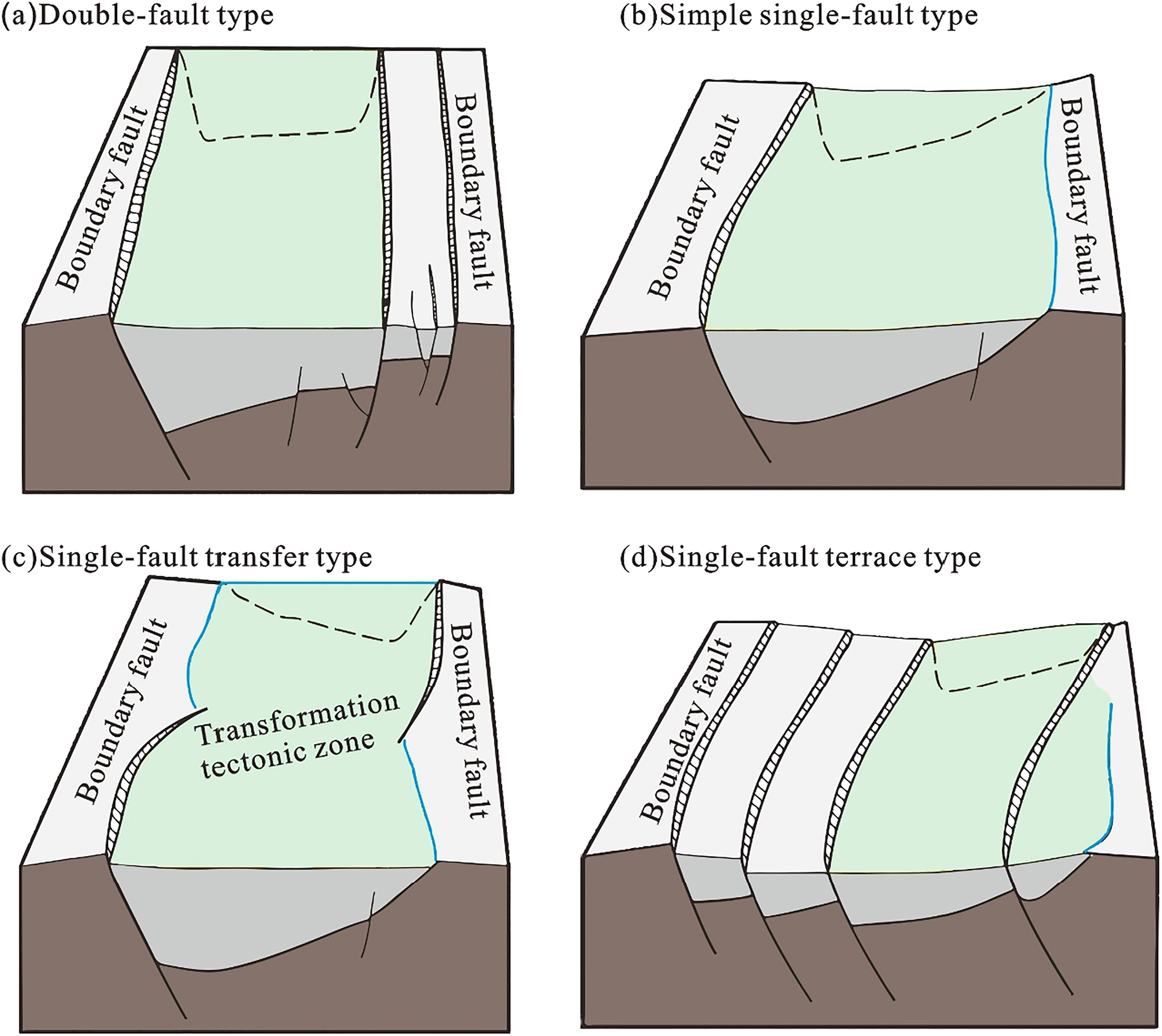
Structural styles of various rifts in the EARS, (a) double-fault type, (b) simple single-fault type, (c) single-fault transfer type, (d) single-fault terrace type.
Double-fault rifts mainly form in the Albertine Rift located at the northern end of the Western Branch of the EARS (Figure 5(a)). Both sides of such rifts are controlled by boundary faults that dip steeply at angles greater than 45°, and faulting was continuous during the period of rift development. Such rifts have stable depocenters and are characterized by structural inheritance, wide distribution range, and large stratigraphic thickness (more than 5000 m) (Figure 6(a)).
Simple single-fault rifts mainly form in the Lokichar Rift and the Turkana Rift in the Eastern Branch of the EARS and in the Kivu Rift and the Rukwa Rift in the Western Branch of the EARS (Figures 4(a), (b) and 5(b), (c)). The structural styles of the simple single-fault rifts in the Eastern Branch are controlled by regional tectonic setting and crustal thickness. In the Eastern Branch, simple single-fault rifts mainly form in the tectonically active zones of East Africa, the crustal thickness is smaller than that of the Western Branch, and the underground magmatic activity is intense (Jia et al., 2021). There is usually a boundary fault on one side of each of these simple single-fault rifts, and these rifts are generally small in scale. In the Western Branch, the rifts distributed from north to south are situated in different tectonic environments, some small rifts have formed in the transfer zones between large rifts, and the horizontal extensional stress is relatively low. Therefore, boundary faults are usually formed on only one side of each rift. Boundary faults dip gently at angles smaller than 45°. The extensions of basins are limited, the rates of subsidence of boundary faults are low, and the ranges of the corresponding subsidence centers and deposition centers are limited (Figure 6(b)).
Single-fault transfer rifts mainly form in the Tanganyika Rift in the Western Branch of the EARS. Such rifts are controlled by boundary faults on only one side, and the controlling boundary faults usually dip steeply at angles greater than 45° (Figure 5(c) to (e)). The polarity is reversed along the long axes of such rifts, and transfer zones and accommodation faults form at connections. During the regional extension of the Tanganyika Rift, the extensions of adjacent rift segments were different, and the rates of subsidence varied from one boundary fault to another. For the same rift segment, the rate of extension of the rift and the rate of subsistence of the corresponding boundary fault vary from one evolution stage to another (Figure 6(c)).
Single-fault terrace rifts mainly form in the southern section of the Eastern Branch of the EARS (Figure 4(c)). Compared with the simple single-fault rifts in the northern section of the Eastern Branch of the EARS, these single-fault terrace rifts are subject to lower horizontal extensional stress. A series of fault terraces have formed beside boundary faults (on only one side of each boundary fault), and boundary faults usually dip gently at angles smaller than 45°. Affected by volcanic activity, the fractures are mainly filled with igneous and pyroclastic rocks. The scales of lake basins have been greatly reduced, the ranges of subsidence centers and deposition centers are limited, and the thicknesses of sedimentary strata are small (Figure 6(d)).
In summary, the large rifts in the Western Branch of the EARS, such as the Albertine Rift, the Tanganyika Rift, and the Malawi Rift, are mainly of double-fault type and single-fault transfer type, and only some small rifts in this branch are of simple single-fault type. The rifts in the Eastern Branch of the EARS are generally small in scale. The rifts in the northern section of the Eastern Branch are mainly of simple single-fault type, and those in the southern section are mainly of single-fault terrace type.
Difference in sediment fill between the eastern and western branches of the EARS
The Eastern Branch of the EARS was formed during the Oligocene, and the Western Branch was formed during the Middle Miocene. It is obvious that the Eastern Branch was formed earlier than the Western Branch (Figure 7). The formation process of the spatially continuous Cenozoic rift segments of the Eastern Branch is temporally discontinuous. Specifically, the South Lokichar Rift and the Kerio Rift formed first, and the other rifts formed later. In the Eastern Branch, the sediment thickness ranges from 2 km to 6 km, the Cenozoic strata are well-developed, and the main types of rocks are continental clastic rock and volcanic rock. The fractures in the northern section of the Eastern Branch in Ethiopia and the southern section of the Eastern Branch in Tanzania are mainly filled with igneous rocks, and clastic rocks are relatively well-developed in the Lokichar Rift, the Turkana Rift, and the Kerio Rift in Kenya (Figure 7). In the Western Branch of the EARS, the sediment thickness ranges from 2 to 7 km; the Cenozoic strata are generally well-developed (Macgregor et al., 2015; Jia et al., 2021); the Karoo and Cretaceous sequences have been formed south of the Tanganyika Rift; the Cenozoic sequences are composed primarily of continental clastic rocks; lacustrine mudstones are relatively well-developed, and volcanic rocks have been formed locally (Figure 7). In summary, the Western Branch of the EARS consists of rifts formed in multiple stages, where the main type of rock is continental clastic rock, and igneous rocks have been formed locally, while more stable and thicker sequences of igneous rocks have been formed in the Eastern Branch of the EARS (Macgregor et al., 2015).
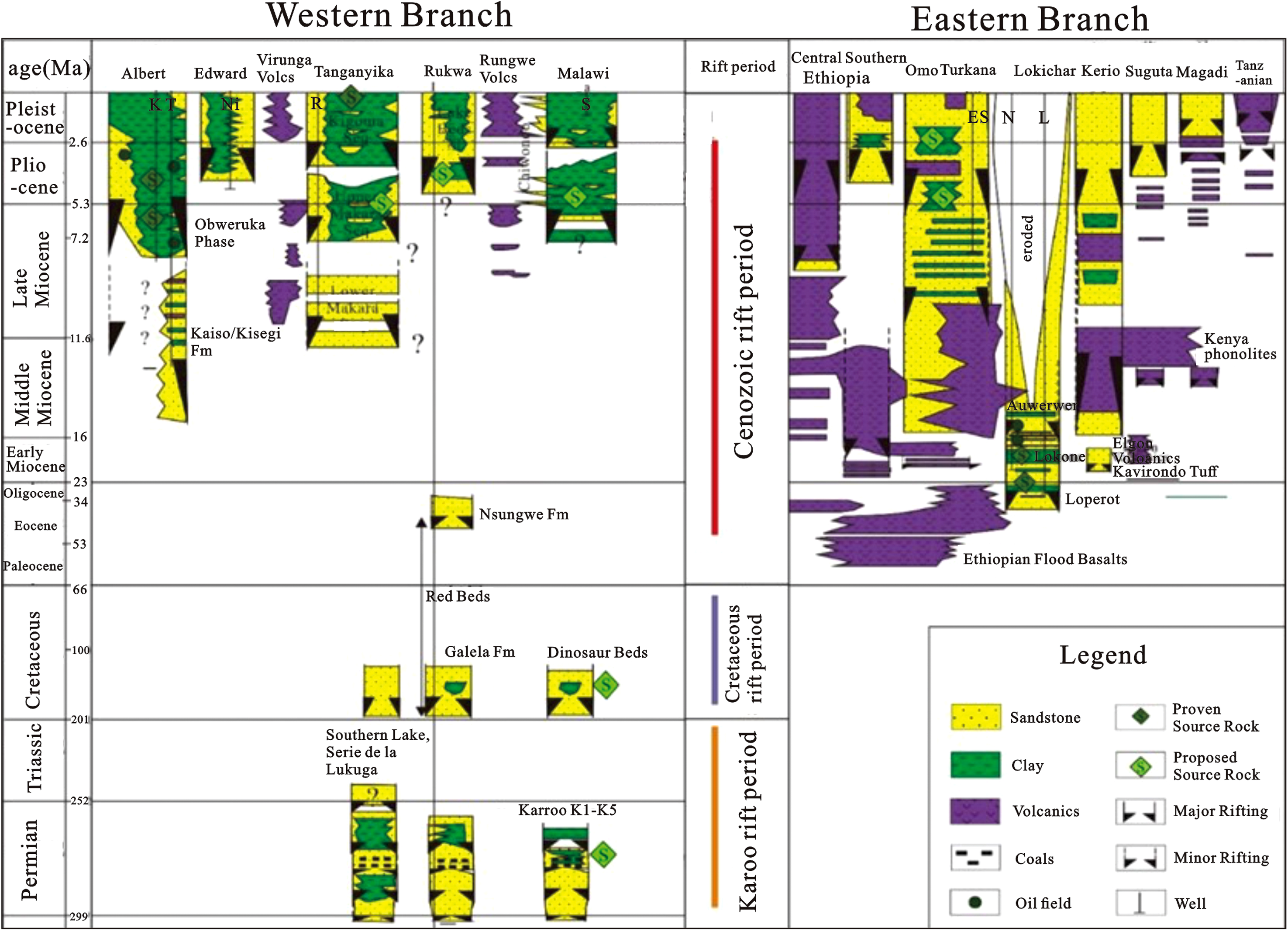
Stratigraphic comparison between the eastern and western branches of the EARS. Wells: K = Kingfisher, T = Turaco, Ni = Nyuni, R = Ruzizi, I = Ivuna, S = Syracuse, ES = Eliye Springs, L = loperot, N = Ngamia (modified from Macgregor et al., 2015).
Comparison of reservoir elements between the eastern and western branches of the EARS
Oil and gas discoveries have been made only in the Albertine Rift in the Western Branch of the EARS and the South Lokichar Rift in the Eastern Branch, and no breakthrough has been made in hydrocarbon exploration in the other rifts. Therefore, this section mainly focuses on the Albertine Rift and the South Lokichar Rift and compares their reservoir elements in order to determine their similarities and differences and provide the basis for evaluating the exploration potential of various rifts.
Source rocks
The source rocks in the Albertine Rift and the South Lokichar Rift are relatively young, all of which were formed during the Cenozoic. These source rocks are of good quality. The source rocks in the central lake basin of the Albertine Rift are of the highest quality. The Lower Miocene source rocks in the South Lokichar Rift are in the peak phase of hydrocarbon generation, and they are the main source rocks in the rift. In view of the fact that Karoo and Cretaceous sequences have been formed in the southern section of the Western Branch of the EARS, the possibility of the development/existence of source rocks in these two sequences cannot be ruled out. Due to frequent volcanic activities in the Eastern Branch of the EARS, the TOC value of the source rocks in the South Lokichar Rift are significantly greater than those of the source rocks in the Albertine Rift in the Western Branch of the EARS, and the hydrocarbon generation depth of the South Lokichar Rift is less than that of the Albertine Rift (Jia et al., 2018, 2021).
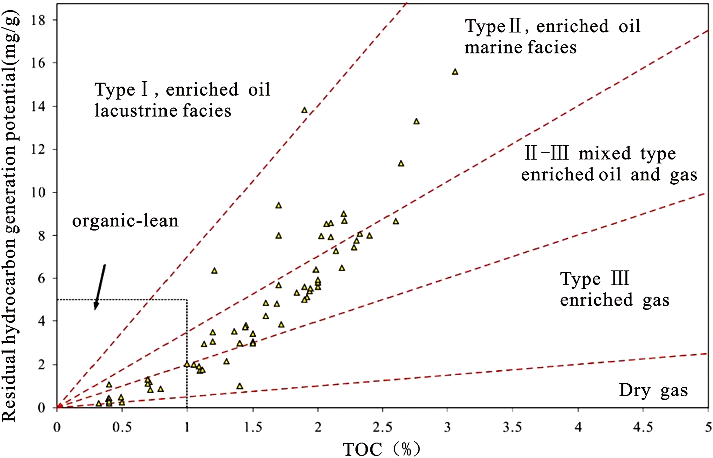
East Africa is situated near the equator, with a warm climate, abundant rainfall, and thriving algae. These environmental conditions are highly favorable for the formation of organic-rich lacustrine mudstones (Wen et al., 2012b). The source rocks in the Albertine Rift are Miocene-Lower Pliocene semi-deep to deep lacustrine mudstones. The drilling data of Well Waki B-1 reveals that the mudstones in the Middle Miocene Kisegi Formation have TOC values ranging between 6% and 7%, contain Type II-III kerogens, and have hydrocarbon generation potential of 2–10 mg/g, indicating that these mudstones are high-quality source rocks (Figure 8); the lacustrine shales in the Middle Miocene Kasande Formation have TOC values ranging between 5% and 8%, mainly contain Type III kerogen, with an HI values of 250 mgS2/g TOC and a Tmax value (maximum temperature) of 440 °C, and are currently buried at depths ranging between 1900 and 2100 m. The lacustrine shales in the Middle Miocene-Upper Miocene Kakara Formation have TOC values ranging from 2% to 6%, mainly contain Type I-II kerogens, and are currently buried at depths below 2100 m. The geothermal gradient of the Albertine Rift is high, which is about 4 °C/100 m on average, and the oil window is between 1600 and 3500 m (Table 1). Both suites of source rocks are distributed within this depth range and are currently in the peak phase of oil generation (Jia et al., 2021; Wen et al., 2012b). In addition, effective source rocks are widely distributed in the Albertine Rift, and oil seeps, asphalt seeps, and oil slicks have been discovered in many places in the Albertine Rift (Cheng et al., 2002), indicating that this rift basin has a great hydrocarbon-generating capacity.
TOC and hydrocarbon generation potential of the source rocks in the Albertine Rift (modified from Wen et al., 2012b).
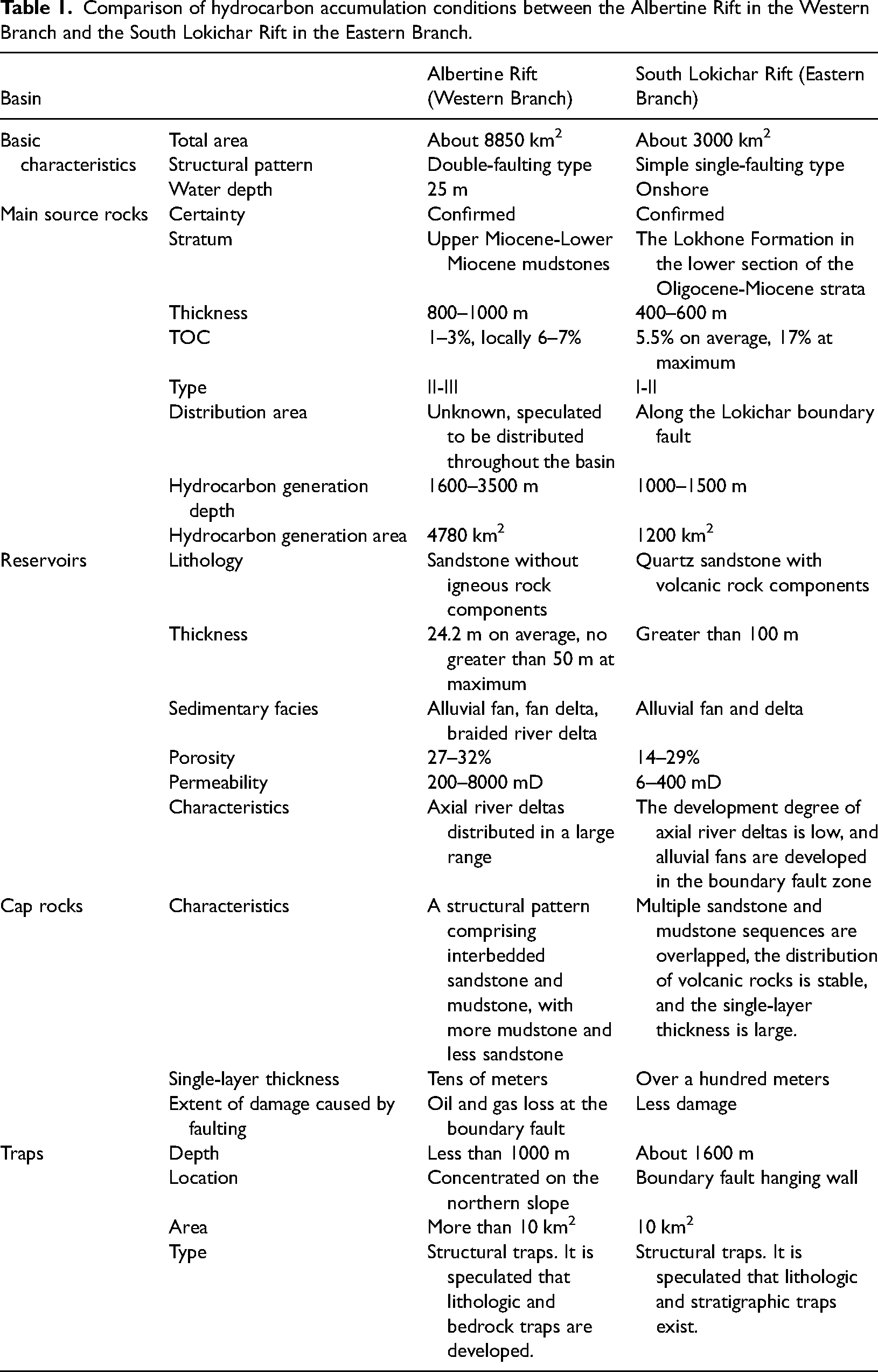
Comparison of hydrocarbon accumulation conditions between the Albertine Rift in the Western Branch and the South Lokichar Rift in the Eastern Branch.
The South Lokichar Rift also has two suites of source rocks. The main source rocks in the rift are the shales of the Lower Miocene Lokhone Shale Formation. These shales have an effective thickness ranging between 400 and 600 m, mainly contain Type I-II kerogens, and have TOC values ranging from 1% to 17%, with an average of 5.5%, and RO values ranging between 0.6% and 0.65%, a Tmax value of 448 °C, and an HI value of 600 mgS2/gTOC, indicating that these shales are mature source rocks (Table 1). According to the interpretation of seismic data, the area of mature source rocks at the bottom of the Lower Miocene Lokhone mudstone of can reach 500 km2, and the area of mature source rocks at the bottom of the Oligocene Loperot Formation can reach 1000 km2. The estimated amounts of hydrocarbons generated by these two suites of source rocks are about 190 × 108 and 18.1 × 10⁸ m3, respectively. Jia et al. (2022) conducted simulations based on the drilling data of 10 drilled wells and thereby determined the maturity levels of these source rocks. The simulation results show that the mature source rocks cover a total area of about 1200 km2, hydrocarbon generation and expulsion started at 14 and at 11 Ma, respectively, and these source rocks are still in the peak phase of hydrocarbon generation and expulsion. The Oligocene Loperot Shale Formation is another suite of secondary source rocks. The quality of these secondary source rocks is lower than that of the shales in the Lokhone Shale Formation, which is mainly related to the sedimentary environment at the time of deposition. Specifically, these source rocks (shales) are more than 200 m thick, mainly contain Type II-III kerogens, and have TOC values ranging between 0.2% and 3.3% and RO values ranging between 1.05% and 1.10%, indicating that they are highly mature. This suite of source rocks has been encountered only in the gentle slope zone in the east of the South Lokichar Rift (Table 1). Therefore, the conditions of the source rocks in the South Lokichar Rift are highly favorable for hydrocarbon generation and expulsion (Hu et al., 2019; Jia et al., 2018; Rop and Patwardhan, 2013; Tiercelin et al., 2008).
Reservoirs
A fluvial-lacustrine-deltaic depositional system has developed in the Albertine Rift in the Western Branch of the EARS (Simon et al., 2017; Zhang and Scholz, 2015). The main reservoirs in the Albertine Rift are the sandstone bodies of the axial river delta, which generally have good petrophysical properties (Jia et al., 2021). The main reservoirs in the South Lokichar Rift in the Eastern Branch of the EARS are the sandstone bodies of the alluvial fan confined by boundary faults in the steep slope zone, among which high-quality sandstone bodies are distributed in the center and margin of the alluvial fan, and the reservoirs at the apex of the alluvial fan are tight (Table 1). In general, the reservoirs in the Albertine Rift have better petrophysical properties than the South Lokichar Rift. In addition, because the reservoirs in the Albertine Rift mainly consist of axial fluvial-deltaic deposits, the distribution range of these reservoirs is larger than that of the reservoirs in the alluvial fan confined by boundary faults in the South Lokichar Rift.
The main reservoirs in the Albertine Rift are composed primarily of Upper Miocene-Pliocene sandstones. Braided river-delta deposits are distributed along the long axis of the rift basin, the Victoria Nile delta has long been formed in the northern tectonic transfer zone, where the sandstone bodies are of good quality, and fan deltas mainly form along the short axis of the basin (Figure 9). The Albertine Rift is characterized by young evolutionary age, short burial time, small burial depth, weak diagenesis, and good reservoir properties. For example, in the Kingfisher Oilfield discovered in the steep slope zone, lacustrine and deltaic sandstones are the most important lithofacies, and the drilling data shows that the ratio of sandstone thickness to formation thickness ranges from 15% to 50%. The reservoir has good petrophysical properties, average porosity of nearly 30%, well-developed primary intergranular pores, permeability ranging from 300 to 2500 mD, well-connected pores, and thick oil-bearing layers. In the Mupta and Waraga oilfields, the porosity and permeability ranges of the reservoir are 28–32%, 27–30%, 200–1000 mD, and 6000–8000 mD, respectively (Tumushabe et al., 2022; Wen et al., 2012b) (Table 1). The analysis of thin sections in Figure 10(a) and (b) shows that the reservoirs are relatively well-developed and have good petrophysical properties. From the perspective of porosity and permeability, the reservoir has a large storage capacity, medium to high porosity, and medium to high permeability, and they are of good quality.
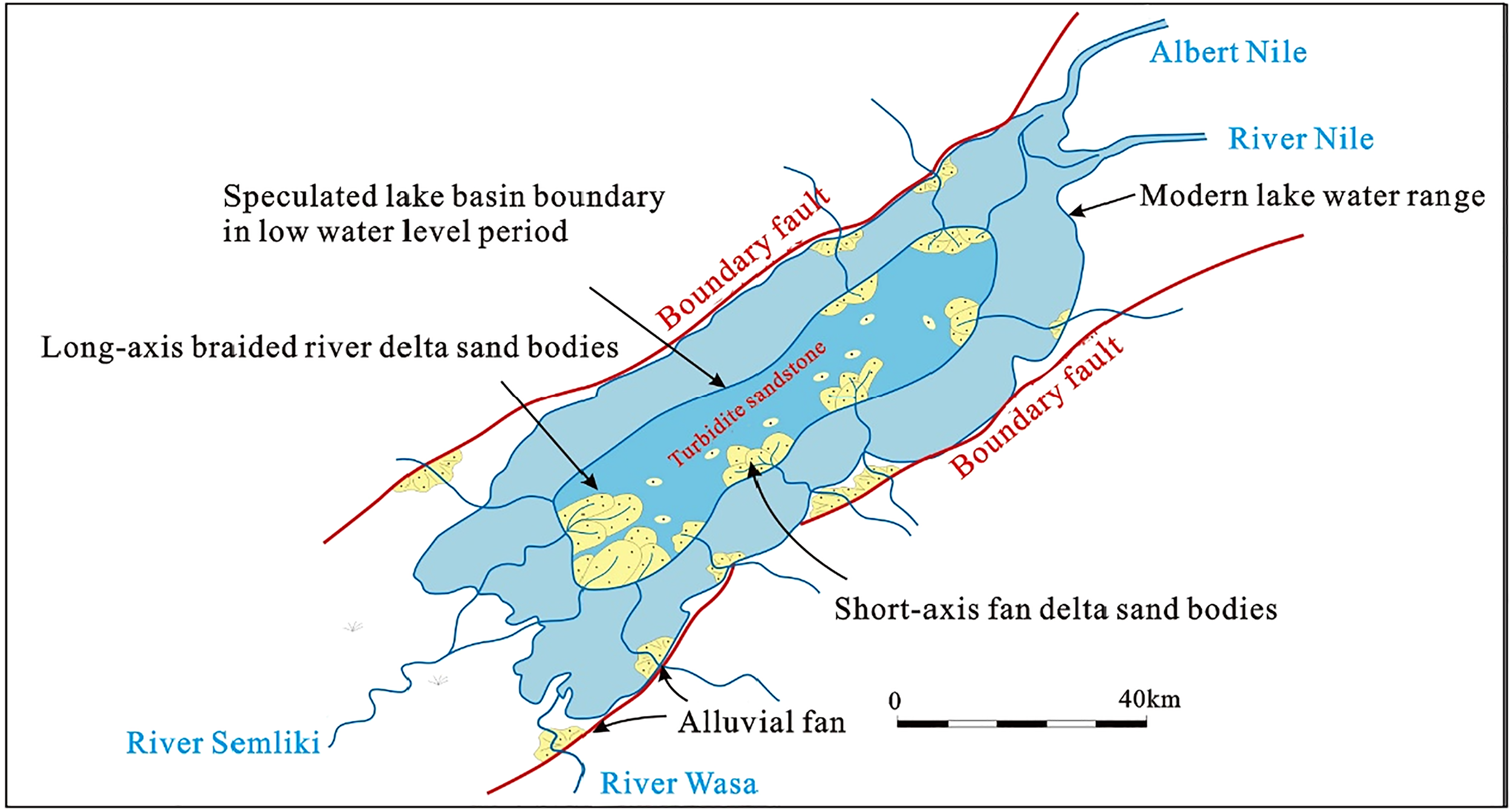
Depositional pattern of the Albertine Rift (modified from Wen et al., 2012b).
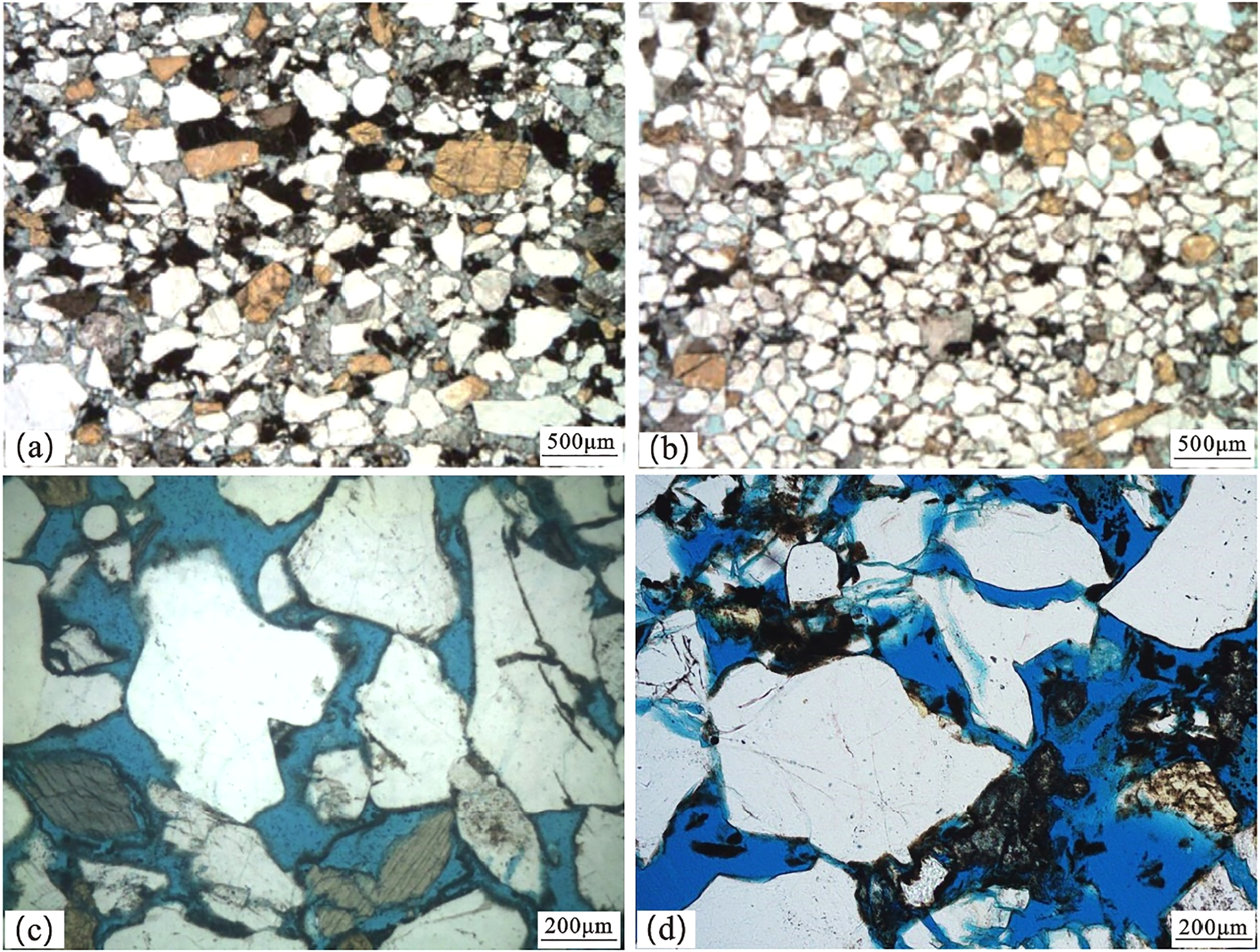
Reservoir microscopic characteristics in East African Rift, (a) Albertine Rift, Western Branch, well X, 2000 m; (b) Albertine Rift, Western Branch, well X, 2008 m; (c) South Lokichar Rift, Eastern Branch, well T, 1585 m; (d) South Lokichar Rift, Eastern Branch, well E, 1253 m (from Han and Zhao, 2018).
The reservoirs in the South Lokichar Rift include the sandstones of the Middle Miocene Auwerwer Formation and the Lower Miocene Lokhone Formation. The depositional environments along the axis of the South Lokichar Rift and in the eastern gentle slope zone are fluvial-deltaic environments, where the sandstones are well sorted due to long-distance sediment transport (Figure 11). The depositional environments in the steep slope zone are alluvial fan and fan delta. The sandstones of the alluvial fan are poorly sorted, and the reservoir has poor petrophysical properties. The fan delta has been modified by lake water, so effective reservoirs can be formed there (Figure 11). Therefore, in the depositional environments of the delta and fan delta fronts in the South Lokichar Rift, high-quality reservoirs can form, and turbidite sandstone reservoirs can also form. The main sedimentary facies of the sandstones in the Auwerwer Formation in the South Lokichar Rift are fluvial-deltaic facies, and this sandstone interval is the most important reservoir interval. The burial depth of the sandstone interval is less than 1700 m. The drilling data of Well Ngamia-1 shows that this reservoir has porosity ranging between 23% and 29% and permeability ranging from 6.07 to 405.3 mD (Zhang et al., 2017). Microscopic observation of the core samples from Well T shows that the reservoir space is mainly composed of intergranular pores (Figure 10), with permeability of 6–400 mD and a thickness of 775 m in the oil-bearing section. The sandstones of the Lokhone Formation are buried more deeply than those of the Auwerwer Formation, with average porosity of 14%.
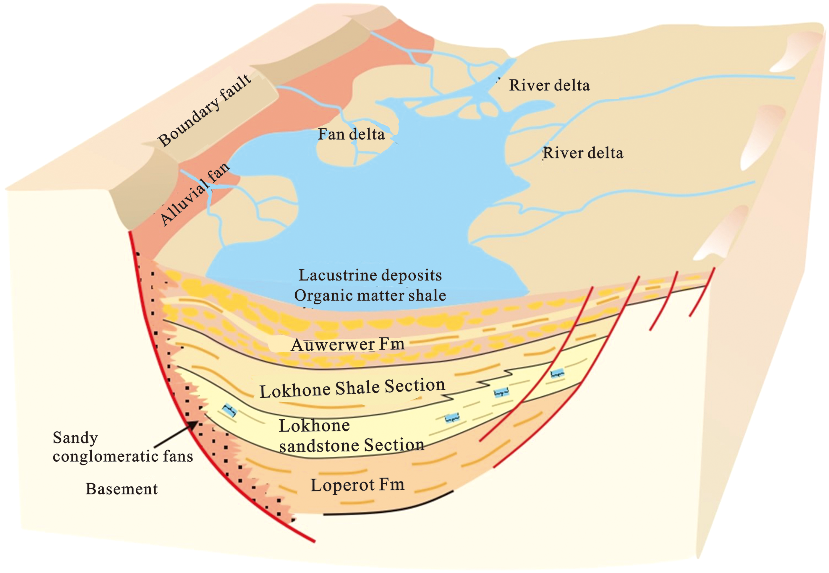
Depositional pattern of the Auwerwer Formation in the South Lokichar Rift (modified from Zhang et al., 2017).
Seals (cap rocks)
The main cap rocks in both the South Lokichar Rift and the Albertine Rift are overlying mudstones. However, the single-layer thickness of the cap rocks in the South Lokichar Rift can reach hundreds of meters, while that of the cap rocks in the Albertine Rift is only tens of meters. In addition, the cap rocks in the South Lokichar Rift have suffered less damage, and the stable and thick layers of igneous rocks formed in the rift can also serve as effective regional seals.
Currently, the EARS is still growing. Due to the lack of depressions at the top of the rift system, no seal widely distributed across the entire basin has been formed. In the Albertine Rift, a stable sequence of mudstone deposits with a thickness of 20–70 m has been formed in the middle of the Kilegi Formation and at the bottom of the Kaiso Formation (Figure 12), which is composed of sediments deposited when the lake water level rose to the maximum flooding surface in the rifting stage (Simon et al., 2017; Wen et al., 2012b). This mudstone sequence is a good regional seal that can provide effective sealing.
Hydrocarbon accumulation model of the Albert Rift.
The main cap rocks in the South Lokichar Rift are the mudstones of the Middle Miocene Auwerwer Formation and the Lower Miocene Lokhone Shale Formation (Zhang et al., 2017). Despite its poor petrophysical properties, the glutenite fan formed in the western steep slope zone can still provide effective lateral sealing. In addition, the igneous rocks at the top of the Miocene formation can also form a local seal. The drilling, logging and seismic data reveals that a widely distributed, well-developed, and stable Auwerwer shale section formed during the high-water-level stage was encountered during drilling in the main sandstone reservoir of the Auwerwer Formation, with a thickness of up to 80–120 m. This shale section forms an effective regional seal (Figure 11). The main depositional environments in the eastern gentle slope zone are fan delta and braided river delta (Cui et al., 2018). In these environments, the sediments have been transported over a long distance and are well sorted, and the reservoirs have good petrophysical properties, but the oil and gas reserves are limited. The drilling data reveals that there are no oil and gas shows in the Auwerwer Formation below the primary target zone, but most of the thin sandstone layers of the underlying Lokhone Formation contain oil. The reason is that, after the mudstones of the Lokhone Formation were deposited in the basin, the eastern part of the basin was uplifted continuously, the strata of the lower member of the Auwerwer Formation were exposed at the surface and denuded during uplift, and due to the lack of regional seals in the gentle slope zone in the eastern part of the basin, the faults in this zone could not provide effective sealing.
Traps
Almost all of the traps discovered in the Albertine Rift originate from structures such as fault blocks and nose-shaped structures. The fault-block traps in this rift are mainly distributed beside large boundary faults (on one side), and fault-block or fault-nose traps can form in the transfer/slope zones at both ends of the rift (Figure 12). Potentially favorable traps include lithologic traps and bedrock buried hills. The lithological targets are gravity-flow sandstones. The boundary faults in the rift basin dip steeply. Seismic data shows that there are large amounts of slope fan and sublacustrine fan deposits in the steep slope zone and sublacustrine zones, which have remarkable reflection characteristics and are easily identifiable (Wen et al., 2012b).
The South Lokichar Rift is similar to the Albertine Rift in terms of trap type. For these two rifts, structural traps are the main type of trap (Figure 13). The traps on the east and west sides of the South Lokichar Rift are of different types. The main types of traps in the steep slope zone in the west of the basin are rollover anticlines complicated by faults and glutenite updip pinch-out traps (with source rocks in the upper part and reservoir rocks in the upper part); the main types of traps in the gentle slope zone in the east of the basin are traps formed by synthetic or antithetic fault blocks (with source and reservoir rocks in the same interval); it is predicted that there are lithologic, stratigraphic, and composite traps in the gentle slope zone and near the center of the basin (Zhang et al., 2017).
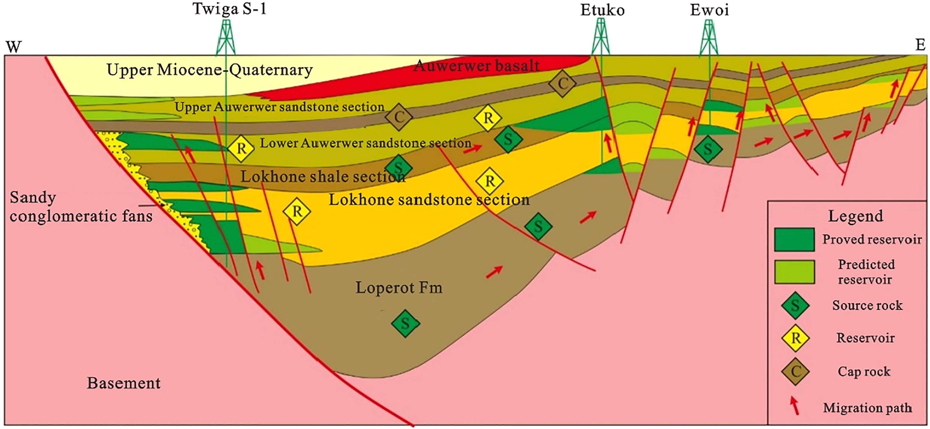
Hydrocarbon accumulation model of the South Lokichar Rift.
Discussion
Main factors controlling hydrocarbon accumulation in the Western Branch of the EARS
Volcanic activity facilitates the maturation of source rocks.
The rifts in the Western Branch of the EARS are large in scale, and lake basins are widely distributed. The formation of lacustrine mudstones during the expansion of lake basins provides favorable conditions for the formation of source rocks. However, these rifts are relatively young in terms of evolution, and the sediment burial time is short. Therefore, the maturation of source rocks is the primary controlling factor. Volcanoes usually form between rifts. Examples of such volcanoes include the Virunga Volcano between the Edward Rift and the Kivu Rift and the South Kivu Volcano between the Kivu Rift and the Tanganyika Rift. Volcanic activity increased the subsurface heat flux and promoted the thermal evolution of source rocks. For this reason, the source rocks in the rift basin have generally reached the hydrocarbon generation threshold. The mature source rocks in the Albertine Rift accounts are present in more than 80% of the basin area, which is indicative of a wide range of hydrocarbon supply.
Effective source-reservoir assemblages can improve the efficiency of hydrocarbon supply.
A large number of fan delta sandbodies are developed on the side of boundary faults, and boundary faults controls the range of subsidence and deposition centers. For this reasons, fan delta sandbodies form in close proximity to high-quality source rocks, which promotes the efficient expulsion of hydrocarbons. Large fluvial-deltaic sandbodies have been formed for a long time in gentle slope zones and extent along the long axes of rifts for long distances. Large deltaic sandbodies are in direct contact with source rocks, which is favorable for long-term and long-distance hydrocarbon migration and efficient hydrocarbon expulsion.
Effective hydrocarbon accumulation conditions
Basin-controlling syn-depositional faults are large in scale and can reach the basement, and continuous rifting activity has connected hydrocarbon sources, which is favorable for continuous hydrocarbon migration. According to the theory of over pressed fluid compartment, hydrocarbon migration and accumulation are episodic. During the evolution of rifts, the vertical subsidence rate was high, and no tectonic uplift or denudation occurred, and consequently, the generated hydrocarbons rapidly migrated to the traps in high-potential areas during the period of faulting activity.
Main factors controlling hydrocarbon accumulation in the Eastern Branch of the EARS
The maturation of source rocks is the primary condition for successful exploration.
Since the Paleogene, the EARS has been situated near the equator zone with flourishing flora and fauna and abundant organic matter. Controlled by mantle plumes, underground magmatic activities occur frequently, the geothermal gradient can reach 4.2 °C/100 m, and the hydrocarbon generation threshold is located at low depths (such as 1500 m), providing favorable conditions for the thermal evolution and maturation of source rocks (Wen et al., 2012b). Therefore, based on the analysis above, it is believed that the Eastern Branch of the EARS has favorable conditions for the formation of mature source rocks. This is the main reason for the high hydrocarbon abundance in the Eastern Branch despite its small scale.
The existence of high-quality reservoirs is the decisive factor for large-scale hydrocarbon accumulation.
The main reason for the failure of drilled wells is that reservoirs with good petrophysical properties have not been encountered. For example, Well Engomo-1, which was drilled in 2015, is located onshore northwest of the Turkana Rift in proximity to a boundary fault, and the strata drilled are very tight. Through a comparative analysis considering the depositional patterns of faulted lake basins in eastern China, it has been determined that the main reasons for such failure are the deposition of sandy conglomerate fans near the boundary fault, close proximity to the sediment source, short-distance sediment transport, and large size and poor sorting of sediments. Along the boundary fault toward the center of the lake basin, the petrophysical properties of sandbodies gradually improve. Taking the Amosing Oilfield (discovered west of the South Lokichar Rift) as an example, fans have been subjected to multistage vertical superimposition, and the sandbodies in the internal areas and at the apexes of fans are intercrossed with the semi-deep lake to deep lacustrine muddy sediments. Therefore, these sandbodies change rapidly in both horizontal and vertical directions, forming multiple oil-water systems (S&P Global, 2023). The lake basin is a dustpan-like faulted basin, and the main sedimentary facies distributed in the gentle slope zone and along the axial direction are fluvial-deltaic facies. The sediments have been transported over long distances, are well sorted, and have good physical properties. For example, the sandstones of the Auwerwer Formation in the South Lokichar Rift are dominated by well-connected intergranular pores (Wen et al., 2012b).
The reasonable combination of reservoir elements controls the scale of hydrocarbon accumulation.
The South Lokichar Basin is a faulted lake basin. The sedimentary strata in the basin have experienced multiple lacustrine transgressive-regressive cycles and are mainly composed of interbedded sandstone and mudstone, and source, reservoir and cap rocks occur in proximity to each other and overlap with each other. In the vertical direction, there are two source-reservoir-seal assemblages, namely, the Oligocene-Lower Miocene assemblage, which is composed of Oligocene-Lower Miocene Lokhone sandstones and Lokhone shales, and the Middle-Lower Miocene assemblage, which is composed of Middle-Lower Miocene Auwerwer sandstones and Middle Miocene Auwerwer shales. In these two assemblages, reservoir rocks are in contact with source rocks on a large scale near the source. Meanwhile, faults connect the two suites of source rocks and the upper and lower source-reservoir-seal assemblages, thus improving the efficiency of hydrocarbon accumulation and hydrocarbon abundance. Therefore, the reasonable combination of various reservoir elements controls the scale of hydrocarbon accumulation.
Control of structural style over hydrocarbon accumulation in the EARS
Structural style controls sediment filling.
For intracontinental rift basins, the tectonic evolution and geometry of rifts and the paleotopographic and paleoclimate conditions formed under the influence of rifts determine sediment filling in such basins.
From the discussion above, it can be seen that the evolution of various rifts in the EARS started late, these rifts mainly experienced the pre-rift, syn-rift and post-rift stages, and three corresponding sequences were formed in the vertical direction. For the lower alluvial sequence, due to the small scale of faulting at the early stage of rift evolution, the accommodation space in the basin is limited, and the volume of sediment is larger than the accommodation space. Due to these reasons, after the accommodation space was filled, the surplus water and sediment flew over the lowest overflow point. Therefore, the depositional system in this sequence is dominated by fluvial facies. For the middle lacustrine sequence, with the intensification of faulting, the continuous extension of the boundary fault and the rise of overflow points, the basin's accommodation space increased greatly, due to which the sediment deposition rate was insufficient for filling the accommodation space and the basin was undercompensated. Therefore, the main sedimentary facies in the basin are lacustrine facies, and some fluvial-deltaic depositional systems have developed along the basin margin. For the upper deltaic-fluvial sequence, faulting activity declined in the late stage of rifting, the accommodation space of the basin became even smaller, and the basin became overcompensated. Therefore, deltaic-fluvial depositional systems are the main type of depositional system in this sequence.
In the horizontal direction, the four types of rifts with different structural styles have different depositional characteristics. Double-fault rifts are large in scale, and lacustrine mudstones are well-developed and widely distributed in the center of the lake basin. In the short-axis direction, double-fault rifts are controlled by boundary faults on both sides, the footwalls of boundary faults have been uplifted, and a series of fan deltas have formed along the fault plane. In the axial direction, the fluvial-deltaic facies transported over long distances are the main type of filling material (Figure 14(a)). Simple single-fault rifts are comparable to each other in terms of scale, lacustrine strata are well-developed in such rifts, and steep slope zones are mainly controlled by boundary faults. Similar to the case of double-fault rifts, a series of proximal fan delta sandbodies have been formed, the terrains of gentle slope zones are relatively gentle, and braided river delta sandbodies have been formed (Figure 14(b)). Single-fault transfer rifts are large in scale, and their depositional characteristics are similar to those of simple single-fault rifts. For such rifts, steep slope zones are dominated by fan deltas, while gentle slope zones are dominated by braided river deltas. Due to the low-lying terrain in the transition zone between rift segments, some rivers diverted to enter the lake in the transition zone, forming large-scale braided river delta sandbodies (Figure 14(c)). Single-fault terrace rifts are mainly distributed in the southern section of the Eastern Branch of the EARS and are small in scale. Seasonal lakes are the major type of lake formed in single-fault terrace rifts. Such rifts are characterized by limited deposition of lacustrine mudstone, strong volcanism, and large amounts of volcanic rocks as sediment fills. For single-fault terrace rifts, braided river deltas mainly form in gentle slope zones, where igneous clasts are the dominant type of sediment, sandstones composed of magmatic and igneous clasts are prone to diagenesis, and clay minerals are formed under shallow burial conditions (Figure 14(d)).
Schematic diagram of sedimentary filling patterns of different structural styles of rifts in the EARS, (a) double-fault type, (b) simple single-fault type, (c) single-fault transfer type, (d) single-fault terrace type.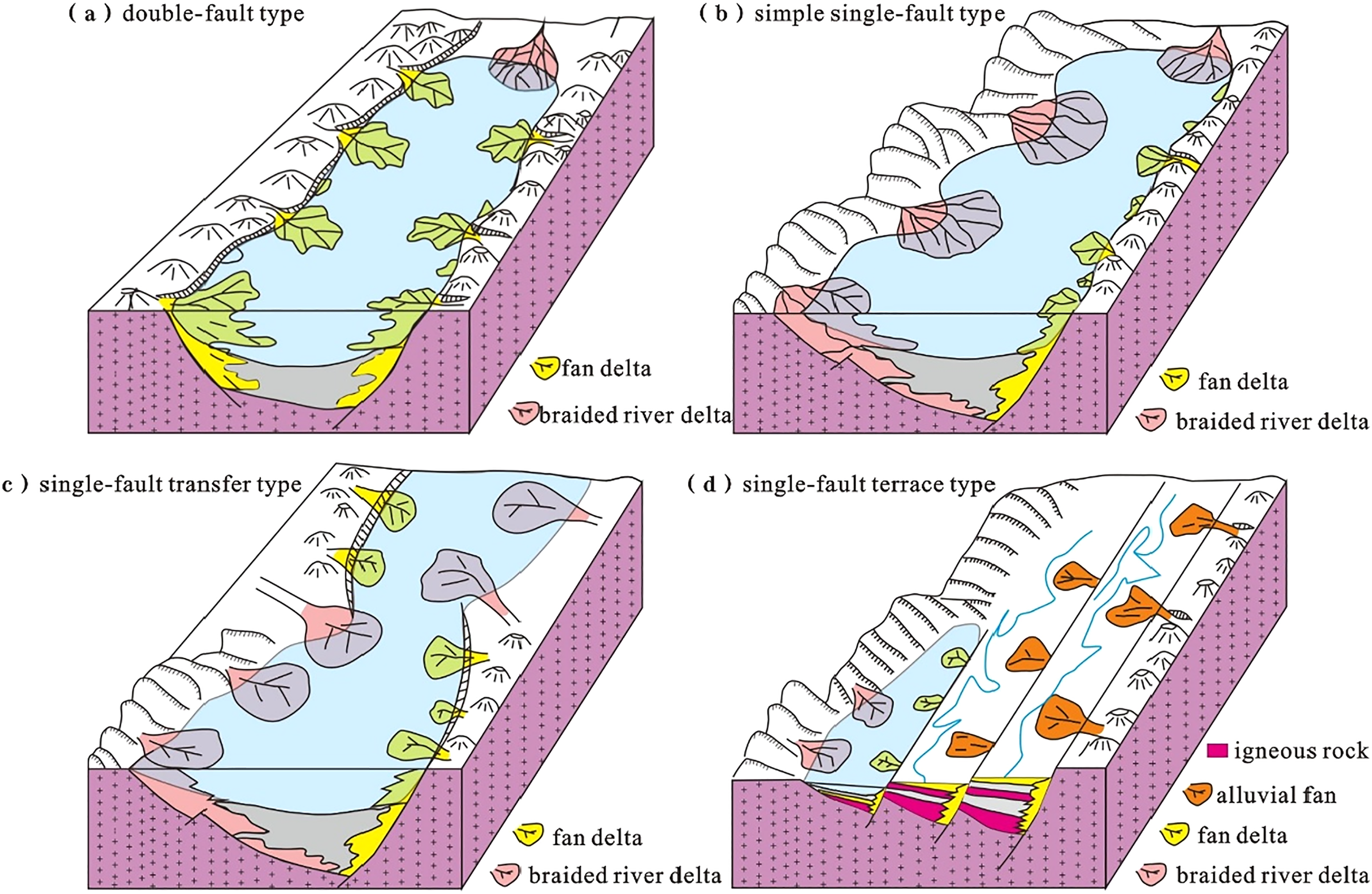
Structural style controls source rocks.
Structural style determines the scale and evolution of rift basins in the horizontal and vertical directions. In the vertical direction, the characteristics of sediment fills indicate that the central lacustrine sequences were deposited during the period of steady subsidence of the lake basin and rapid deepening of the lake water, providing favorable conditions for the deposition of dark mudstones.
For rifts with different structural styles, the conditions for the development of source rocks are different. Double-fault rifts are controlled by boundary faults on both sides. For this reason, the related basins subsided continuously during the syn-rift stage, and the subsidence centers remained stable, providing favorable conditions for the deposition of lacustrine mudstones. Taking the Albertine Rift as an example, the subsidence rate could reach 400 m/Ma during the syn-rift stage (Wen et al., 2012b). Single-fault transfer rifts are controlled by boundary faults on only one side. Therefore, the related half-grabens are distributed in a scattered fashion. During the rifting phase, the boundary faults controlling various half-grabens became active successively. As a result thereof, the related depocenters migrated with the evolution of single-fault transfer rifts, which restricts the deposition of lacustrine mudstones to a certain extent. However, during the evolution of rifts experiencing continuous subsidence, the hanging walls of the related faults subsided to greater depths, and the depth of lake water remained at a certain level, providing favorable conditions for the deposition of lacustrine mudstones. The development of simple single-fault rifts is characterized by good inheritance. Simple single-fault rifts are comparable to each other in terms of scale, and the central lacustrine sequences in such rifts are well-developed, providing favorable conditions for the formation and development of source rocks. The development scale of single-fault terrace rifts is the smallest. Volcanic activity is more intense in the single-fault terrace rifts of the Eastern Branch of the EARS, and these rifts are therefore mainly filled with igneous rocks. Moreover, the deposition of lacustrine mudstones is most limited in these rifts. These phenomena are unfavorable for the formation and development of source rocks. Therefore, the conditions for the formation of source rocks need to be determined first when evaluating the single-fault terrace rifts of the Eastern Branch.
Structural style controls the distribution of sandbodies.
For rift basins with different structural styles have different conditions for the formation of reservoirs. For the Albertine Rift (which is a double-fault rift), due to the formation of a large number of fan delta sandbodies on both sides of the rift in the short-axis direction and the large throw and strong continuous activity of boundary faults, fan deltas have been formed on a large scale in multiple stages, and very thick fan delta sandbodies are continuously distributed in the horizontal direction and vertically superimposed. In the long-axis direction, braided river deltas with large sandbodies have been formed. In single-fault transfer rifts, fan delta sandbodies have been formed on the side of the boundary fault. Similar to the case of double-fault rifts, the terrains of transition zones between half-grabens in single-fault transfer rifts are lower than the surrounding areas, and for this reason, the surrounding water systems often converge in these zones, where river deltas with large sandbodies and good petrophysical properties have been formed. In simple single-fault rifts such as the South Lokichar Rift, fan delta sandbodies have been formed in steep slope zones and fluvial-deltaic sandbodies have been formed in gentle slope zones, which is similar to case of single-fault transfer rifts. In single-fault terrace rifts, multiple parallel fault terraces have been formed on one side of the boundary fault, and seasonal lakes with water bodies with limited range and depth are the major type of lake, alluvial fans and fan deltas have developed in steep slope zones, and river deltas have developed in gentle slope zones (but the scale of river deltas is limited). In addition, single-fault terrace rifts are greatly affected by volcanic activity and mainly filled with igneous rocks, and the number of reservoirs formed in such rifts is the smallest compared to other types of rifts. Currently, no oil and gas discoveries have been made in the Eastern Branch of the EARS.
Structural style controls hydrocarbon migration and accumulation systems.
Structural style controls hydrocarbon migration pathways. Rifts with different structural styles have different hydrocarbon migration pathways. Double-fault rifts such as the Albertine Rift are controlled by boundary faults on both sides, and boundary faults can reach the basement, thus connecting hydrocarbon sources. Therefore, boundary faults can directly serve as hydrocarbon migration pathways. In single-fault transfer rifts and simple single-fault rifts, hydrocarbons can migrate along boundary faults in steep slope zones, but in gentle slope zones, hydrocarbons mainly migrate along permeable carrier beds, secondary faults, and stratigraphic unconformities. Therefore, the efficiency of hydrocarbon migration in gentle slope zones is lower than that in steep slope zones.
Structural style controls reservoir-seal (cap rock) assemblages. For the oil and gas fields discovered in the northern section of the Albertine Rift, the main reservoir-seal assemblages are composed of superimposed delta front subfacies (sandstone) and plain subfacies (mudstone), and the cap rocks in these fields have good sealing performance and can form good reservoir-seal assemblages together with reservoir rocks. Most of the oil and gas fields discovered in the steep slope zones of the South Lokichar Rift are controlled by the sealing performance of tight sandy conglomerate fans.
Exploration potential of the EARS
West side of the Albertine Rift
The oilfields discovered in the Albertine Rift are concentrated at the northern end and in the east of the rift in Uganda. For double-fault rift basins, the boundary faults on both sides play similar roles in controlling hydrocarbon accumulation. Therefore, it is believed that the Bunia boundary fault on the west side and the Semliki Valley in the southwest also provide favorable conditions for hydrocarbon accumulation (Figures 1(c) and 2(b)).
Some oil seeps distributed along the fault zone have been discovered near the Bunia boundary fault on the west side (Abeinomugisha and Kasande, 2012), which indicates the alteration of related reservoirs to some extent during the active faulting period and confirms the possibility of subsurface hydrocarbon accumulation. The Semliki Valley in the southwest is similar to the Victoria Nile Delta in the northeast. In the Semliki Valley, the deltas formed in multiple stages are vertically stacked, and the discovery of the adjacent Kingfisher Oilfield confirms the existence of the hydrocarbon supply center in the south, indicating that this area has great potential for hydrocarbon accumulation.
Southeast of the Tanganyika Rift
The Tanganyika Rift began to form in the Middle Miocene. Unlike the Albertine Rift, the Tanganyika Rift has evolved to a lesser extent, and it is still in a major stage of rifting. Faults are well-developed in this rift, mainly including faults shaped like “Y”, reversed “Y” and inverted “V”, step faults, and domino-style faults. In addition, accommodation zones are also well-developed, which consist of a variety of transform structures, such as synthetic structures, anticlinal structures, and antithetic structures. The depocenter is favorable for the development of source rocks, and the TOC of the source rocks in the core zone of the central lake basin at 1400 m depth is 12% (Oppo and Hurst, 2018), which is higher than that of the source rocks in the Albertine Rift, indicating that these source rocks have great hydrocarbon exploration potential. The organic matter in the slope zone and at the bottom of the lake basin is of the best quality. In the central part of the Tanganyika Rift, the rate of heat flow is high, and the seal formed by sedimentary rocks is thick. These favorable conditions can fully support hydrocarbon generation. In addition, the discovery of numerous active oil seeps also verifies the existence of effective petroleum systems (Oppo and Hurst, 2018). Compared with the Albertine Rift, the sandstone bodies in the slope zone of the Tanganyika Rift may have been weakly reformed, and the permeability of the reservoirs in the Tanganyika Rift is lower than that of the reservoirs in the Albertine Rift. Lake Tanganyika is deeper than Lake Albert; therefore, the sandstone bodies in Lake Tanganyika should be smaller than those in Lake Albert in terms of scale and single-layer thickness. In summary, the Tanganyika Rift has favorable conditions for the formation of high-quality source rocks and ideal source-reservoir-seal assemblages, and the half-graben slope zone is the most favorable area for hydrocarbon migration. Moreover, the sandstone bodies in this area are highly developed and should therefore be able to provide favorable conditions for hydrocarbon accumulation.
Kerio Rift
The Kerio Rift is adjacent to the east side of the South Lokichar Rift. During the early Miocene, the Lokhone Horst on the east side of the South Lokichar Rift was not uplifted, the sedimentary rocks of the Lokhone Formation were deposited in the Kerio Rift and the South Lokichar Rift simultaneously, and the shale sequence of the Lokhone Formation was possibly formed in the Kerio Rift at the same time (Zhang et al., 2017). Therefore, the source rocks in the Kerio Rift are as mature as those in the South Lokichar Rift. The drilling of wells Kodos-1 and Epir-1 targeted at the structural traps in the steep slope zone, which was commenced in 2014, was unsuccessful (S&P Global, 2023). The main reason is that the formations encountered during drilling are composed of alluvial fan deposits and have poor petrophysical properties. Therefore, to facilitate hydrocarbon exploration in the steep slope zone of the dustpan-shaped rift basin, it is necessary to focus on the identification of glutenite fans in order to find reservoirs with good petrophysical properties.
Land in the northwest of the Turkana Rift
Oil seeps and slicks have been discovered on the land in the northwest of the Turkana Rift and on the surface of Lake Turkana, respectively, indicating that there are active petroleum systems in this area. Available data suggests that the evolution of this area started slightly later than that of the South Lokichar Basin, and two fluvial-lacustrine sedimentary sequences have been formed in this area since the Late Miocene (Tiercelin et al., 2004). The burial depth of the lacustrine mudstones on top of the lower sedimentary sequence is more than 2.5 km, reaching the threshold depth for hydrocarbon generation, which means that these mudstones have hydrocarbon generation potential. In addition, seismic data shows that there are well-developed structural traps and structural-lithologic composite traps near the boundary faults in the west of the lacustrine rift basin.
Conclusion
The Eastern Branch of the EARS was formed slightly earlier than the Western Branch. As the Eastern Branch was formed, the sediments filled the sedimentary strata that had been formed since the Oligocene. The Western Branch was formed at a slightly later time. As this branch was formed, the sediments filled the sedimentary strata that had been formed since the Miocene and overlay the pre-existing, residual Karoo rift sequence in the south.
Based on the characteristics of rift development, the forms of fault combinations, and the characteristics of development of transfer zones, the rifts of the EARS have been classified into four types depending on their structural styles, namely, double-fault type, simple single-fault type, single-fault transfer type, and single-fault terrace type. The Albertine Rift, the Tanganyika Rift, and the Malawi Rift, are mainly of double-fault type and single-fault transfer type. The rifts in the northern section of the Eastern Branch are mainly of simple single-fault type, and those in the southern section are mainly of single-fault terrace type.
The comparative analysis of reservoir elements in the eastern and western branches of the EARS shows that the source rocks in both branches are of good quality. The main reservoirs in the Albertine Rift are the sandstone bodies of the axial river delta, which generally have good petrophysical properties. The main reservoirs in the South Lokichar Rift in the Eastern Branch of the EARS are the sandstone bodies of the alluvial fan confined by boundary faults in the steep slope zone, among which high-quality sandstone bodies are distributed in the central and marginal of the alluvial fan. For the South Lokichar Rift and the Albertine Rift, structural traps are the main type of trap.
Structural style controls sediment filling, source rocks, the distribution of sandbodies, and hydrocarbon migration and accumulation systems. In general, the hydrocarbon potential of double-fault rifts is the greatest, followed by that of simple single-fault rifts and single-fault transfer rifts, and the hydrocarbon potential of single-fault terrace rifts is limited. Our research shows that the west side of the Albertine Rift, the southeast of the Tanganyika Rift, the Kerio Rift, and the land in the northwest of the Turkana Rift have great exploration potential.
Footnotes
Declaration of conflicting interests
The author(s) declared no potential conflicts of interest with respect to the research, authorship, and/or publication of this article.
Funding
The author(s) disclosed receipt of the following financial support for the research, authorship, and/or publication of this article: This study is supported by China National Petroleum Corporation's Special Science and Technology Project titled “Research on new theories of overseas oil and gas geology, new technology for resource evaluation and advanced selection of favorable exploration areas” (2023ZZ07) and China National Petroleum Corporation's Project titled “A study on the hydrocarbon accumulation rules of six types of basins around the world based on multiple geological attribute traceability and localization” (2023ZZ0701).