
Abstract
Once a coal seam has been weathered and oxidized, the quality of the coal is lost and the coal resources are wasted. At the same time, new risks are introduced to the safe operation of the coal mine. Therefore, it is critical to determine the extent of the weathered and oxidized zone in the coal seam. This paper depicts the electromagnetic characteristics of the weathered and oxidized zone of coal seams, briefly introduces the method of detection by transient electromagnetic method (TEM) and the data processing steps, and performs the numerical simulation for the simplified resistivity model of weathered and oxidized zone in a coal seam. It is observed that after the coal seam has been weathered and oxidized, the electromagnetic characteristics (secondary field potential and resistivity) will be dramatically affected, namely high secondary field potential and low resistivity. For experimental verification purposes, this study selects the test project of the Shixin Minefield in Shanxi, China as an example, and the accuracy for the detection of the weathered and oxidized zone of the coal seam using TEM is successfully verified.
Keywords
Introduction
Due to crustal movement, coal seams buried deep in the crust are exposed to the surface or buried in the shallow crust A variety of intrinsic physical and chemical features of coal seams may be modified as a result of the interplay of temperature variations, gas, water, and biological activity, in turn producing a weathered zone, and this process is known as weathering. In the weathering process, in addition to the dissolution of water, there is also oxidation, thus forming an oxidized zone. A weathered zone and an oxidized zone are often collectively referred to as a weathered and oxidized zone. The weathered and oxidized zone of a coal seam generally develops in an outcrop or shallow buried area, and the depth of the weathered and oxidized zone differs due to the influence of various factors such as topography, rock layer properties, structure, and hydrogeological conditions (Cui et al., 2015; Yang, 2019; Zhan and Wang, 2016). The weathered and oxidized effect of coal seam greatly affects the effective mining of coal seams, thereby causing direct economic losses and waste of resources. It can even result in spontaneous combustion of coal seams, gas and coal dust explosions, smoke poisoning, or casualties (Wang and Liu, 2014).
At present, methods for detecting weathered and oxidized zones in coal seams include sonic logging, roadway high-density electrical approaches, roadway seismic investigation, and drilling. The time difference between the sound wave traveling from the sending probe through the formation to the receiving probe is recorded using sonic logging. The change in the time difference determines the degree of coal seam compactness, and then weathered and oxidized zone of the coal seam can be detected. This method is prone to being influenced by several factors: when the diameter of the well changes, the sonic time difference in the expansion section is reduced, thereby causing false anomalies in the time difference curve; when the layer thickness changes, then the acoustic velocity logging tool has poor resolution for thin formations which are smaller than the spacing; finally, if the stratum is loose or cracks are developed, and the stratum absorbs excessive sound wave energy, this causes the cycle jump to appear as an irregular jump on the sound velocity curve (You and Huang, 2015). The roadway high-density electrical technique measures the electrical differences between the weathered and oxidized zone and the coal seam. Strict building criteria must be adhered to when applying this approach in coal mine roadways (Huang, 2014; Zhang, 2008). Underground seismic exploration is generated and received in the coal-measure strata, absent from the influence of loose surface layer absorption or the shielding effect of the coal-overlying measure's high-speed layer. In addition, the complex working environment in the roadway, along with the irregularity of the distribution of weathered and oxidized zones, further increase the difficulty involved in this method. For example, when the thickness of the coal seam changes greatly and the roof and floor of the coal seam are undulating, then intermittent and short-axis reflection wave groups generally exist on the seismic profile. The continuity of the wave groups is often difficult to track, and stray reflections appear (Huang, 2016; Shan and Li, 2014; Zhan et al., 2015). Finally, as a direct detection method, drilling can effectively reveal the composition, depth, and degree of a weathered and oxidized zone, but it is costly to use, the network is sparse, and it is difficult to accurately locate the small area of weathered and oxidized zone. Therefore, this method is not suitable for large-scale implementation (Cheng and Shi, 2013).
The transient electromagnetic method (TEM) is an effective method that can be used to study the spatial or temporal distribution of electromagnetic fields based on the differences in electrical properties such as the conductivity of rocks or ore bodies in the Earth's crust (Cao et al., 2019; Chen, 2017; Fu et al., 2019; Guo et al., 2020; Lai et al., 2016; Li, 2019), so as to solve geological problems. TEM has the advantages of flexible field source, diverse methods, stability and high efficiency. It has been developed as an important method for detecting oil and gas (Anton et al., 2010; Cairns et al., 1996; Meyer et al., 2016), metal and non-metal minerals (Asten and Duncan, 2012; Cai et al., 2017; Chen et al., 2010; Gao et al., 2016; Qin et al., 2019; Xue et al., 2014; Xue et al., 2020; Xue and Yu, 2017; Yu et al., 2007; Zhi et al., 2016). TEM has been widely applied in the fields of geological structure research (Hisatoshi et al., 2011; Wu et al., 2020), and geothermal exploration (Cheng and Gao, 2011; Di et al., 2019; Tohru et al., 1998; Zhou et al., 2018). However, at present few researchers have attempted to apply TEM to the detection of coal seam weathered and oxidized zone.
In this paper, to verify the effectiveness of TEM in detecting the weathered and oxidized zone of a coal seam, we analyze the geophysical characteristics of weathered and oxidized zone of coal seam, propose implementation steps of data processing, and conduct numerical simulation for a simplified model, taking the project of the Shixin Coal Mine in Shanxi Province, China as an example, and satisfactory detection results are achieved.
Methodology
Geophysical characteristics of a coal seam weathered and oxidized zone
The resistivity of coal is quite high; however, as the degree of weathering and oxidation of coal increases, its resistivity and density exhibit a decreasing trend, while the natural gamma amplitude shows an increasing trend. In weathered coal, due to the increase in the proportion of shale content, the main characteristics are low resistivity, low density, and high natural gamma amplitude. Meanwhile, the main characteristics of oxidized coal show that the resistivity and density are slightly higher than those of weathered coal, which are between normal coal and weathered coal, and the natural gamma amplitude is also between that of normal and weathered coal (Sun and Hu, 2018).
In general, coal seams bear the characteristics of layered distribution, while their electrical characteristics are relatively uniform in the lateral direction, and gradually change according to a certain rule in the vertical direction. When the coal seam is dense and integrated, then the resistivity of the coal seam is relatively high (about 1800–3000 Ω·m, with an average of 2400 Ω·m). However, as the degree of weathering and oxidation of the coal seam increases, its resistivity also exhibits a downward trend. It can be inferred that the deeper the degrees of weathering and oxidation are, the lower the apparent resistivity will be. As an example, the resistivity of oxidized coal is about 1000–2000 Ω·m, with an average of 1500 Ω·m, which is roughly 40% lower than that of normal coal. In addition, the resistivity of weathered coal is about 0–1000 Ω·m, with an average of 500 Ω·m, which is about 80% lower than that of normal coal (Figure 1). This is the geophysical premise for coal seam weathered and oxidized zone detection using the electromagnetic method.
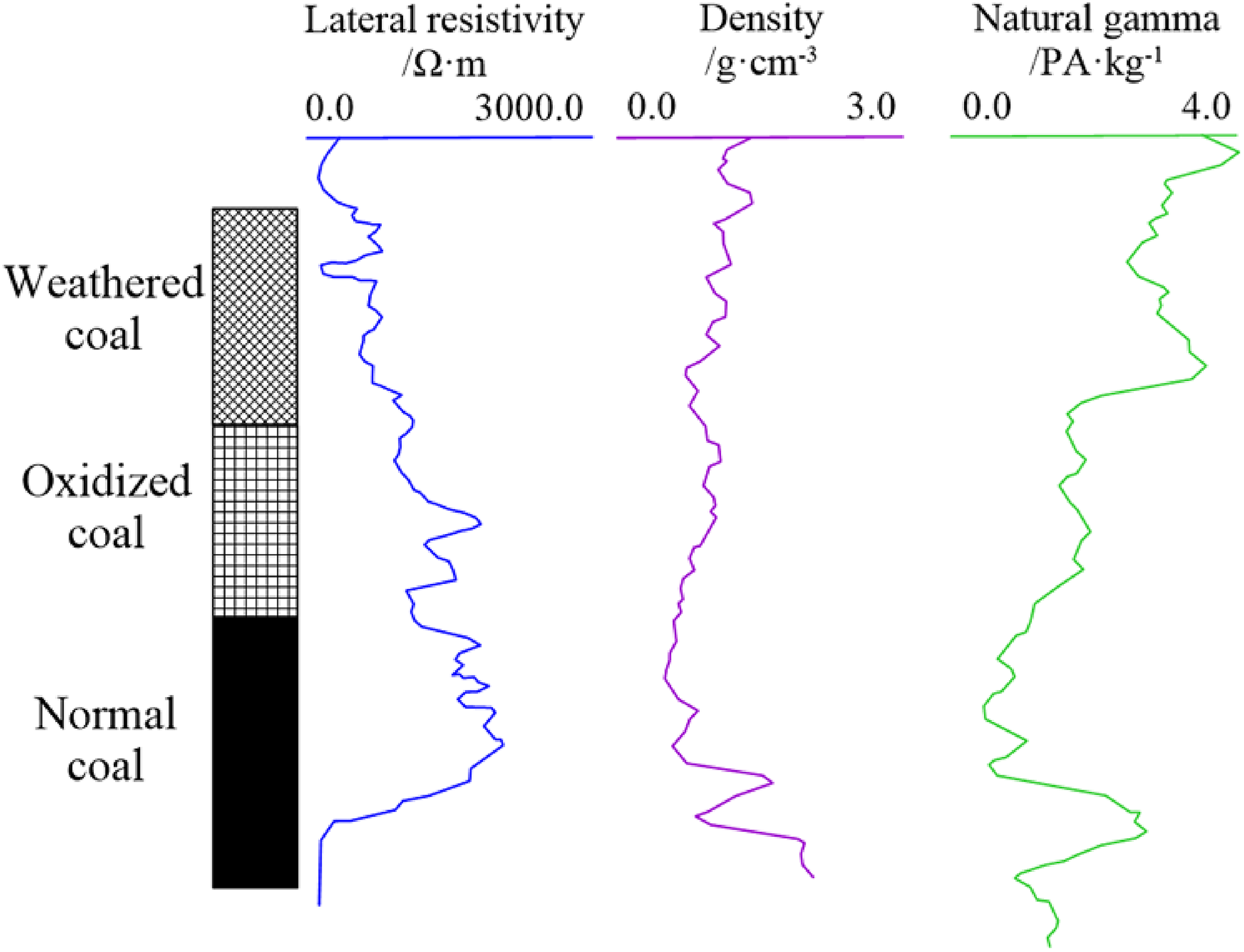
Comparison of geophysical logging characteristics of (a) weathered coal, (b) oxidized coal and (c) normal coal (cited from Sun and Hu, 2018).
TEM methodology
Method selection basis
As mentioned above, the detection methods of the weathered and oxidized zone of coal seams mainly include sonic logging, roadway seismic exploration, roadway high-density electrical method, and drilling. These methods can indicate the characteristics and range of the coal seam weathered and oxidized zone from some aspects, but they all have certain limitations, and the detection accuracy requires improvement. In general, the resistivity of the weathered and oxidized zone is lower than that of the coal seam, and TEM bears a more obvious detection effect on the high-resistivity surrounding rock (since the coal seam is regarded as the high-resistivity surrounding rock), thus it can be used to detect the range of the coal seam weathered and oxidized zone.
Data processing
Based on the processed data, the slice map of the apparent resistivity for the target layer and the contour map of the secondary field potential of a certain channel can be drawn, and the data can be explained according to these two maps. The following method can be used for data processing (Bai et al., 2003; Chen and Xu, 2017; Di et al., 2016; Efthimios and Michael, 2000):
Transmitting the TEM data to the computer, and under the excitation of the step pulse current, the transient response of the ground half-space (vertical component of magnetic induction


The resistivity can be obtained from the transformation of Formula (3), as follows:


Then, we can obtain the following Formulas from Formulas (1) and (2):


Using Formula (8), the secondary field potential at different time channel can be calculated. Then, by cutting the secondary field potential and the resistivity along the target coal seam into slices, the contour map of the secondary field potential and the slice map of the resistivity of the target coal seam can be obtained.
Numerical modeling
In order to verify the ability of TEM to identify weathered and oxidized zone of coal seam, numerical simulation analysis is carried out. The numerical simulation program is the open-source code SIMPEG written by the Geophysical Group of the University of British Columbia, and the forward method is the finite volume method, which is presented as follows.
Electromagnetic method based on the finite volume method
The Maxwell equations satisfied by the electromagnetic field in the time domain can be expressed as follows:


We can divide the calculation area into a series of non-repetitive control volumes in the finite volume method, so that there is a control volume around each calculation point, then integrate each control volume with the differential equation which is to be solved. In this paper, we use Yee's staggered grid (Yee, 1996) for spatial discretization. Taking the
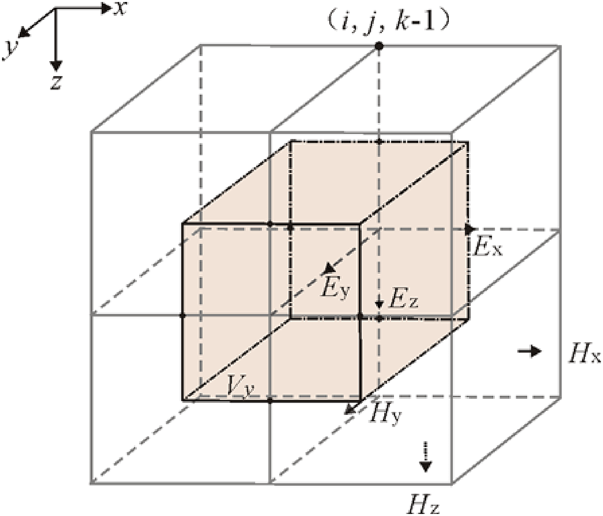
Control volume of E in the Yee grid.
Integrating each variable within its control volume, and then integrating the control volume


The implicit Euler method can then be used, expressed as follows:


Numerical simulation result
Based on the above theoretical analysis, we design a simplified resistivity model and perform numerical simulation (Figure 3). The basic parameters of the TEM numerical calculation are as follows: the transmitting source is a single-turn square loop (200 × 200 m); the voltage responses at different moments are received in the center of the receiving loop; the transmitting waveform is a bipolar rectangular pulse; the time range is 0.48 to 28.7 ms; the number of time channels is 22; and the distance of the receiving point is 20 m.
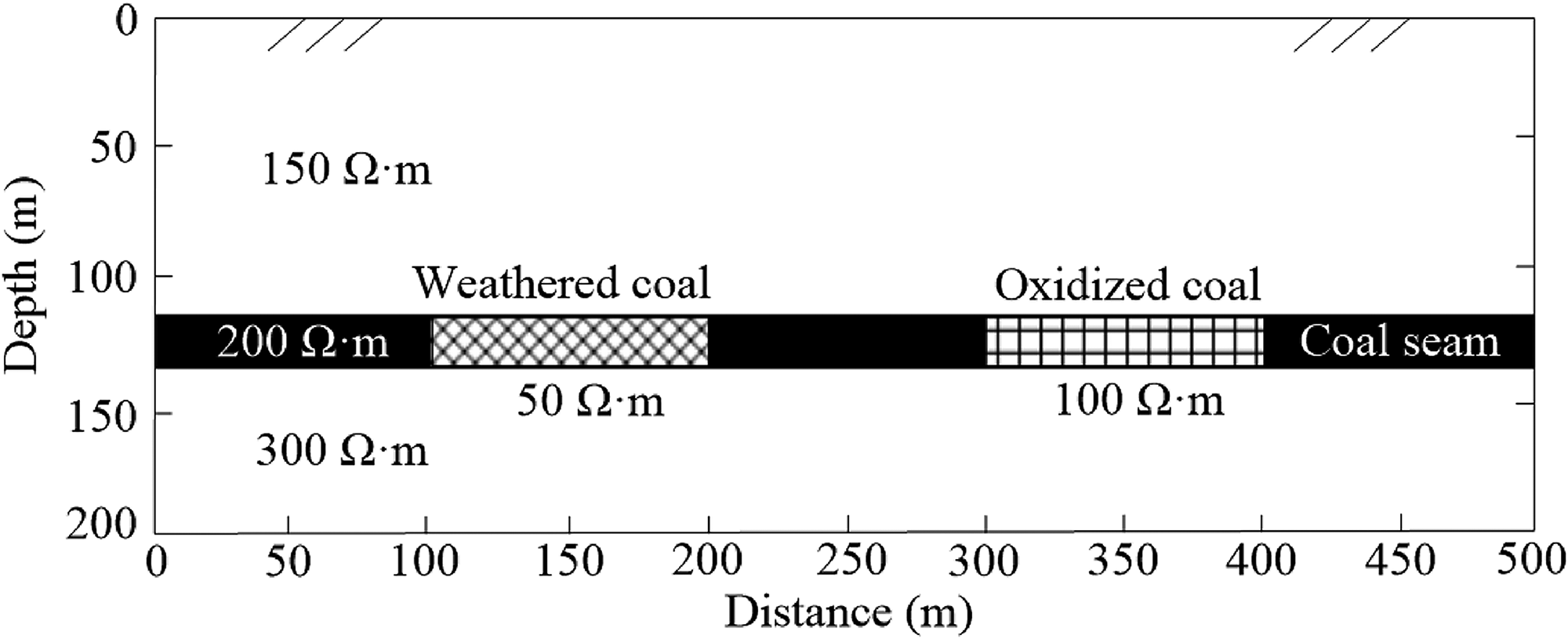
Simplified resistivity model of the geothermal system with the coal seam as the target body.
It can be seen that in the simulated resistivity profile, normal coal, weathered coal, and oxidized coal are all clearly reflected, and there are significant differences among them. Both the weathered and oxidized zones of the coal seam exhibit anomalous characteristics of low resistivity. At the distance of 100–200 m with the depth of about 130 m, the resistivity is as low as 40–80 (Ω·m), reflecting the existence of weathered coal; at the distance of 300–400 m, the resistivity is also lower than that of the normal coal with an range of about 80–120 (Ω·m), which is the manifestation of the coal seam being oxidized. Based on the numerical simulation results, the effect of TEM in detecting the weathered and oxidized zone of coal seam has been well proven theoretically.
Example analysis
Transient electromagnetic exploration was carried out at the Shixin Coal Mine, so as to assess the accuracy of the transient electromagnetic method in located the coal seam weathered and oxidized zone.
Geological setting
The Shixin Coal Mine is located in Gujiao City, Shanxi Province, China. The geographical coordinates are as follows: east longitude 112°15′02″–112°17′03″; north latitude 37°52′20″–37°53′40″ (Figure 4).
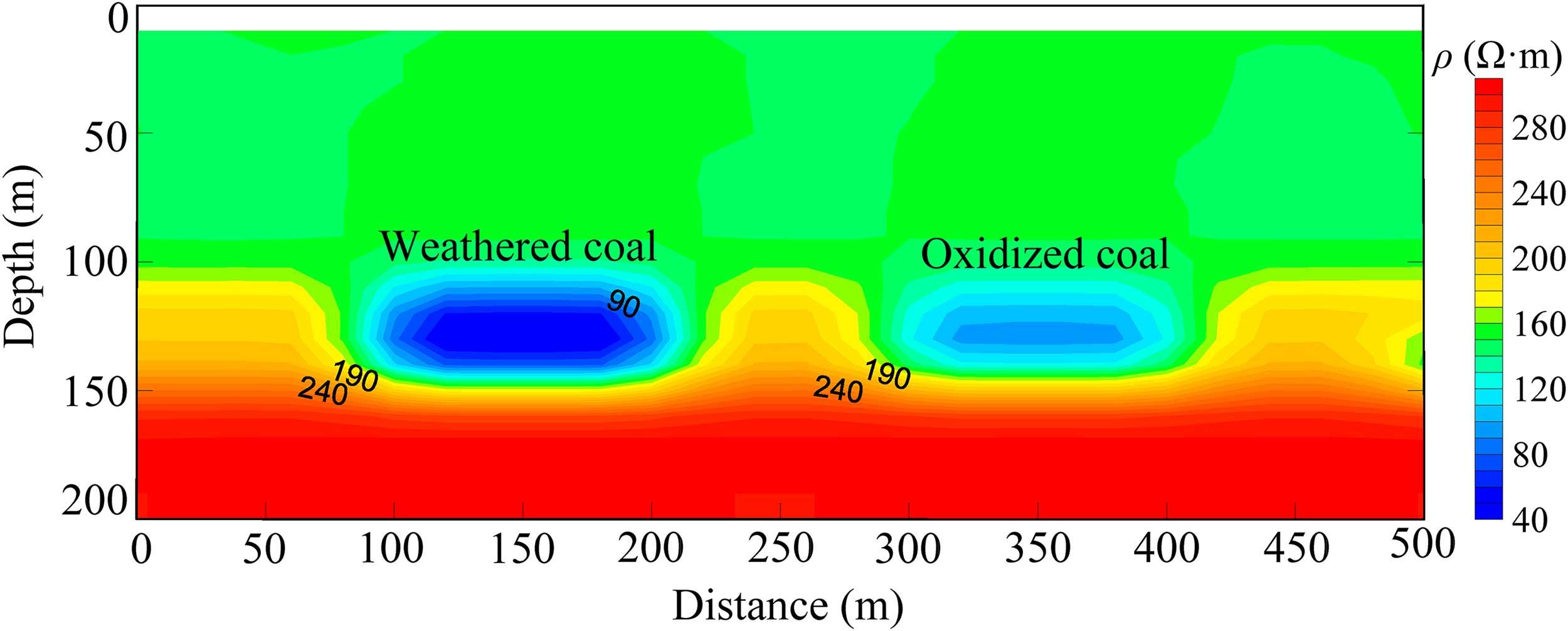
Numerical simulation results of the simplified resistivity model.
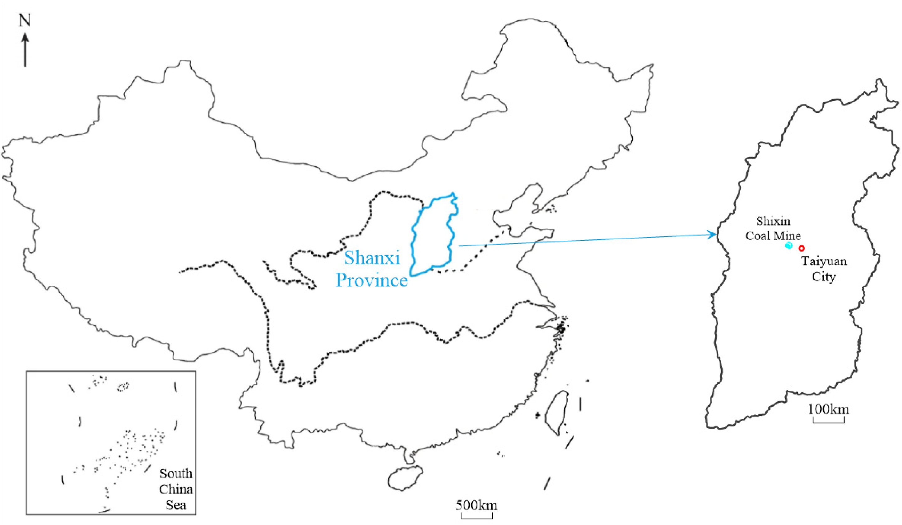
Location of the Shixin Coal Mine.
The strata in the coal mine, from old to new, are as follows: Middle Ordovician Fengfeng Formation (O2f), Benxi Formation of Middle Carboniferous System (C2b), Taiyuan Formation of Upper Carboniferous System (C3t), Lower Permian Shanxi Formation (P1s), Lower Permian Lower Shihezi Formation (P1x), Upper Permian Upper Shihezi Formation (P2s), and fourth series (Q).
Among them, the Lower Permian Shanxi Formation (P1s) is the main coal-bearing formation. This group is continuously deposited on the underlying Taiyuan Formation. It is a set of continental coal-bearing strata. The thickness of the whole group is 43.86–64.74 m, with an average of 52.37 m. The lithology is mainly dark gray and gray-black mudstone, siltstone, and sandy mudstone interposed with gray-white sandstone, containing five layers of coal, of which the numbering from top to bottom is No. 02, 03, 1, 2, 4, among which the No. 2 coal seam is the main mineable coal seam. The No. 2 coal seam is located in the upper part of the Shanxi Formation, which is relatively stable, with a thickness of 0.75–3.00 m, averaging 2.08 m. It has a simple structure, and occasionally contains one layer of gangue. The roof of the No. 2 coal seam consists of fine-grained sandstone, partially sandy mudstone, and siltstone, while the bottom is gray-white, medium-grained quartz sandstone, and partially coarse-grained sandstone. The No. 2 coal seam is a stable mineable coal seam.
According to previous geological data, the weathered and oxidized zone the No. 2 coal seam of the Shixin Coal Mine is mainly located in the eastern and northern parts of the minefield. During the mining of the No. 2 coal seam, it was found that its roof was missing in some areas, and the roof fell during the coal cutting, making it difficult to provide support. The coal mine staff drilled the roof of the No. 2 coal seam at point A in transportation roadway 284 (Figure 6).

Location of transportation roadway 284.
When drilling 2.8 m into the roof of the No. 2 coal seam, phenomena such as dripping water and softening of the rock occurred. It was thus determined that there was a weathered and oxidized zone on the roof of the No. 2 coal seam (Figure 7).
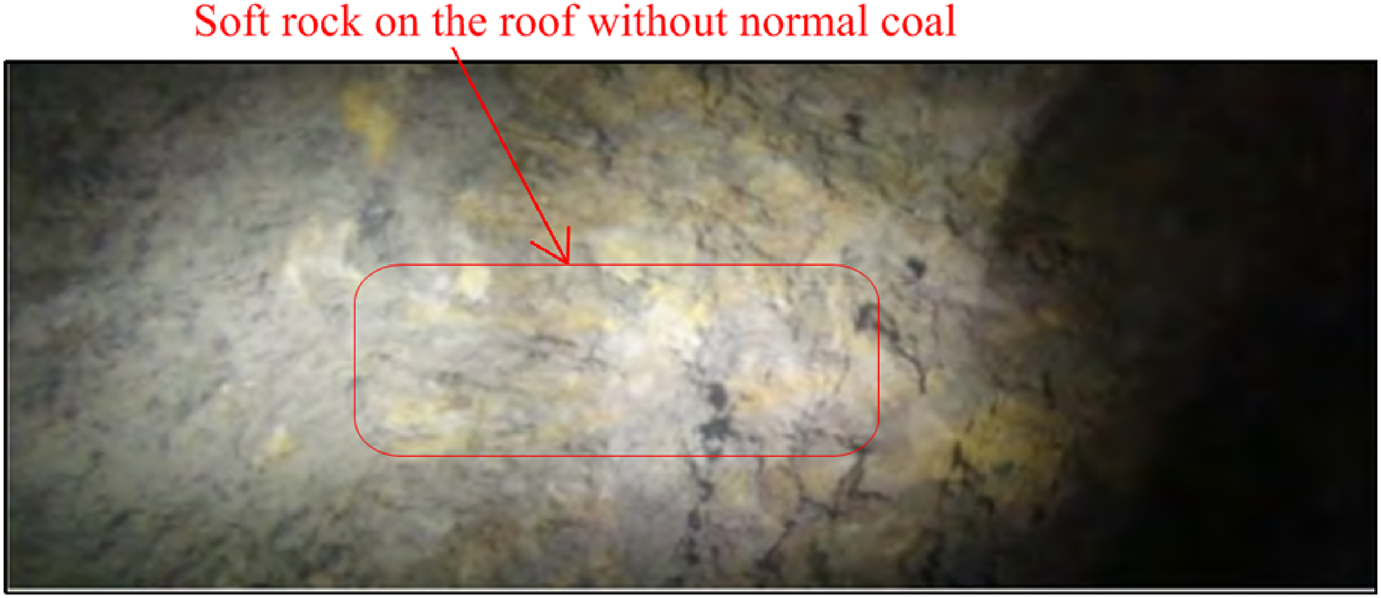
Roof of transportation roadway 284.
However, the reliability of inferring the range of coal seam weathered and oxidized zone only by geological and exploration data is far from sufficient, and is of little significance for the safety production of coal mines. The scope of coal seam weathered and oxidized zone requires further exploration by geophysical methods. The exploration area is the entire minefield of the Shixin Coal Mine, with a total area of 6.3 km2, and there are 61 survey lines laid out. The dimensions of the working network are 40 × 20 m, i.e. the line distance is 40 m and the point distance is 20 m (Figure 6).
Method validity test
In the data collection work, the GDP-32II multi-function workstation of ZONGE Company was used; the configuration of TEM was the center loop device, and data collecting area was within 1/9 of the area inside the loop (i.e. the side length of the data collecting area was 1/3 of the side length of the transmitting loop). The transmitting parameters were as follows: the transmitting loop size was 160 × 160 m, the transmitting current was 8 A, and the number of turns of the transmitting loop was 1. Receiving parameters: the acquisition probe matched with GDP-32II was used to collect the data, which had an equivalent acquisition area of 10,000 m2, and the data sampling delay time was 220 μs.
The method validity test location is selected on line 137 (the green line in Figure 7). According to the underground mining data, the eastern part of this line is the junction of the coal seam weathered and oxidized zone and the normal coal seam. The team decided to test here to distinguish the electrical difference between the weathered and oxidized zone and the normal coal seam.
According to steps described in the previous part “Data Processing,” the fifth surveying channel is the target channel. Figure 8 shows the multi-channel potential profile and resistivity profile of the testing line. It can be seen that there is a high potential abnormality present in the 1360–1600 section in the multi-channel potential profile, and the potential value is greater than 10,060 μV/A (green grid area). This value is regarded as the abnormal potential threshold value, which is approximately 50% higher than the normal section potential value (about 7000 μV/A). In the resistivity profile, there are obvious low-resistivity characteristics (gray grid area) in “Introduction”, 360–1600, and the resistivity value is less than 55 Ω·m, which is roughly 45% smaller than the normal resistivity value (80 Ω·m), which is regarded as the abnormal threshold of resistivity. “Introduction”, 360–1600 is inferred as a coal seam weathered and oxidized zone, which is in good agreement with the results (blue grid grid) revealed by the underground mining data, thus indicating that the use of TEM to detect the scope of the coal seam weathered and oxidized zone is effective.
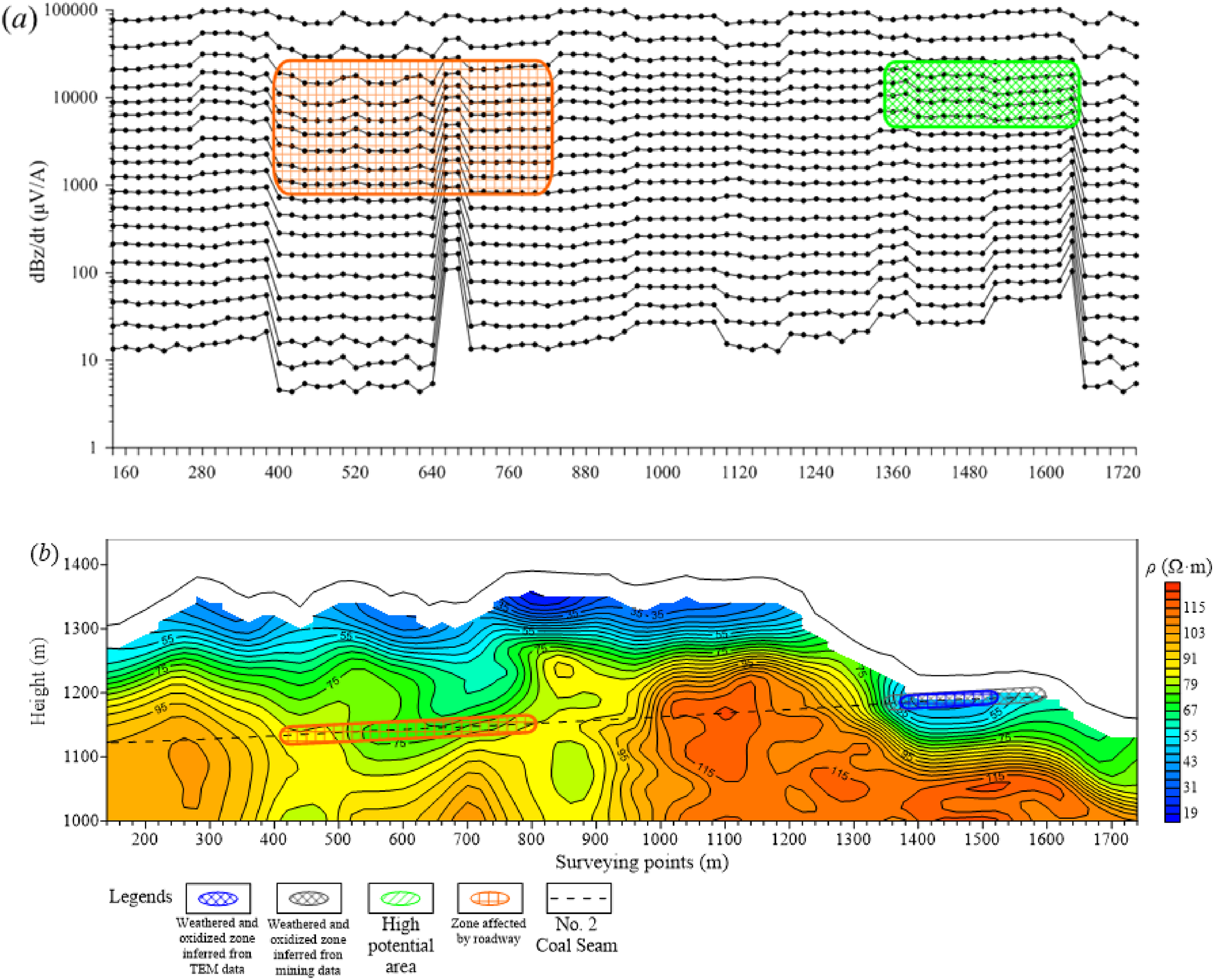
Multi-channel potential profile (a) and resistivity profile of the testing line (b).
Application Effect
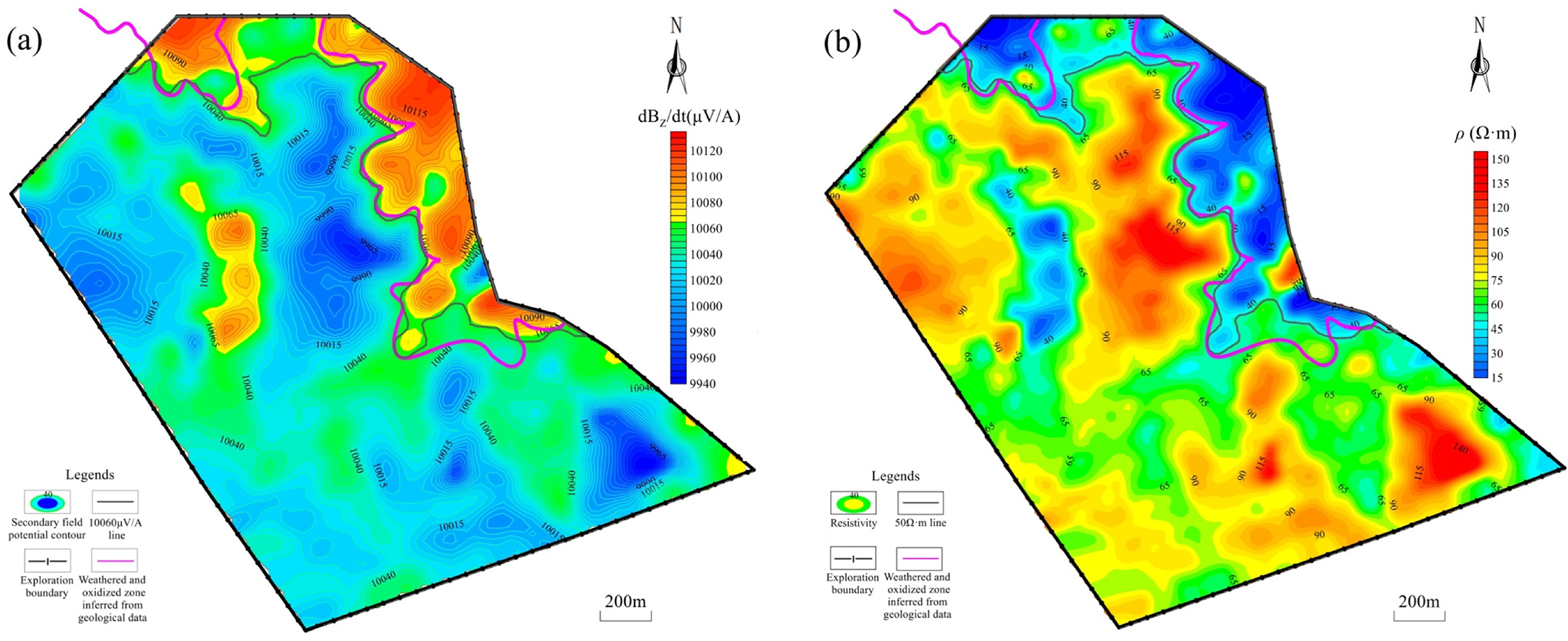
According to the previous steps, the contour map of the secondary field potential of the fifth surveying channel and the slice map of the resistivity of the No. 2 coal seam are drawn, as shown in Figure 9. It can be concluded that the weathered and oxidized zone of the coal seam has two forms of electrical characteristics, i.e. high-potential and low-resistivity.
Comparison of (a) the secondary field potential contour map of the fifth surveying channel and (b) the resistivity slice map of the No. 2 coal seam.
Figure 9 shows the comparison between the contour map of the secondary field potential of the fifth surveying channel and the slice map of the resistivity of the No. 2 coal seam. The following observations can be made:
The secondary field potential in the exploration area is in the range of (9940–10,130) μV/A. According to the test results, the area where the secondary field potential is greater than the abnormal threshold of 10,600 μV/A is treated as a high-potential abnormal area. Two high-potential anomaly areas are delineated, which are located in the eastern and central parts of the exploration area, and the eastern anomaly area is relatively large (the gray range in Figure 9(a)).
In addition, the resistivity in the exploration area undergoes a large overall change, and the resistivity value is between 15–155 (Ω·m). According to the test results, the area where the resistivity value is less than the abnormal threshold of 50 Ω·m is classified as the low-resistivity abnormal area. A total of two low-resistivity anomaly areas are delineated, which are respectively located on the eastern and western sides of the exploration area, and the eastern anomaly area is relatively large (the gray range in Figure 9(b)).
According to the characteristics of secondary field potential and resistivity, combined with geological data, the eastern anomaly area is inferred as the coal seam weathered and oxidized zone.
Discussion
By the above analysis, the effectiveness of TEM to detect the distribution of weathered and oxidized zone of a coal seam has been well verified, and the detection mechanism can be discussed from the aspects of physics and chemistry (Gayle et al., 1984).
On the one hand, when a coal seam is weathered and oxidized, the physical processes include freezing and thawing, and wetting and drying. During freezing, fractures in the coal are extended and enlarged when the increased volume of ice forces unfrozen water farther into the coal. Physical breakdown from wetting and drying is caused by internal stresses that are set up from unequal volume changes that take place as water is absorbed and desorbed faster on the outside of a coal particle than that on the inside. Thus, wetting and drying create fractures that can be extended and enlarged during freezing and thawing; freezing and thawing force water into new areas where wetting and drying can take place, resulting in coal seams with higher void ratios and moisture content.
The primary chemical cause for the creation of coal seam weathered and oxidized zone, on the other hand, is that the roof of the coal measure strata and cracks around the structure emerge, which have strong water circulation conditions. Surface water transports oxygen and carbon dioxide into the earth. Under the leaching action of groundwater, the coal seams dissolve carbonate rocks and sulfate rocks (CaCO3, MgCO3, CaSO4, MgSO4, etc.), the water quality is mainly HCO3-Ca·Mg or SO4·HCO3-Ca·Mg, which has stronger electrical conductivity compared to a normal coal seam (Zhao and Fu, 2008).
Based on these physical-chemical characteristics, it can be seen that after the coal seam is weathered and oxidized, the electrical characteristics will alter significantly, which is mainly reflected in the significant decrease in resistivity. According to these dramatically changes of electrical characteristics, the distribution range of the weathered and oxidized zone of a coal seam can be well detected by the transient electromagnetic method.
Conclusions
Through theoretical and engineering case analysis, some important conclusions are summarized from this study: The weathering and oxidation of coal seam will exert a great influence on coal quality and coal seam mining. Therefore, the identification of the weathered and oxidized zone in the coal seam is critical to the safe production of coal mines. The use of logging data to evaluate physical characteristics is critical. It shows that the resistivity value of the weathered and oxidized zone is at least 40% smaller than that of normal coal, which provides guidance for the creation of transient electromagnetic work, and can decrease work blindness. After the coal seam has been oxidized or weathered, it possesses the electrical properties of “high potential value (50% greater than the normal value) and low resistivity (45% smaller than the normal resistivity value.” The employment of a transient electromagnetic method in the Shixin Coal Mine to identify the coal seam weathered and oxidized zone range is possible and effective, thereby providing a more dependable geological basis for the safe production of coal mines.
Footnotes
Declaration of conflicting interests
The author(s) declared no potential conflicts of interest with respect to the research, authorship, and/or publication of this article.
Funding
The author(s) disclosed receipt of the following financial support for the research, authorship, and/or publication of this article: This Research is sponsored by the National Natural Science Foundation of China (Nos. 41674075, 42062015, and 42174080), co-funded by the Natural Science Foundation of Guangxi Province (Nos. 2016GXNSFGA380004 and 2018AD19204), Research Start-up Foundation of Guilin University of Technology (No. RD2100002165), and China Postdoctoral Science Foundation Funded Project (No. 2021MD703820).
Data availability
The data which support the research are updated with the manuscript.