
Abstract
The Wuwei Basin is located in the Gansu Corridor, which has abundant coalbed methane resources of 2.75 × 10¹¹ m3. However, a low degree of coalbed methane exploration exists, and only a few wells have been drilled in local regions due to insufficient understanding of coalbed methane enrichment and its main controlling factors. This study analyzed the controlling factors of coalbed methane enrichment, including coal reservoir characteristics, hydrogeological conditions, and the original sedimentary environment of the coal-bearing strata. The results showed that the main coal seams were developed in the Taiyuan Formation, and were mostly concentrated in the Yingpan Sag in the south and the Ermahu Sag in the north of the study area. The macrolithotype of the coals in this basin was mainly semi-bright coal with a medium to high rank. Coal macerals were mainly vitrinite, ranging between 65.1% and 91.6% (averaged 81.70%), followed by liptinite, ranging between 1.9% and 29.5% (averaged 8.82%), and inertinite, ranging between 0.2% and 16.5% (averaged 3.66%). Mineral contents varied from 2.5% to 15.1% (averaged 6.16%). The macrolithotype and microlithotype of the Taiyuan Formation coals were favorable for coalbed methane formation. Through comparative analysis of moisture content, ash yield, gas content, and coal-forming sedimentary environments, it was found that the coal formed in the lagoon environment had a higher gas content and lower ash yield than that of the coal formed in the tidal flat environment. The high contents of total dissolved solids in aquifers around coal seams (1.75–16.70 g/L) reflected the closed hydrodynamic environment and were favorable for the preservation of coalbed methane in the Yingpan Sag. Considering various controlling factors (i.e., structure, sedimentation and hydrogeology), three coalbed methane enrichment models were proposed. The model of coalbed methane enrichment in the synclinorium was the most favorable for the enrichment of coalbed methane in the Yingpan Sag.
Introduction
The commercial extraction of methane from coalbeds is well established in a number of countries throughout the world, including the USA, Australia, China, India, and Canada (Moore, 2012). Coalbed methane (CBM) is preserved in several ways, including as adsorbed gas on micropore (<2 nm in diameter) surfaces, trapped gas in the pores of the coal matrix, free gas in the fractures (cleat system), and dissolved in coal seam water (Bustin and Clarkson, 1998; Murray, 1991). CBM exploration and exploitation have the following significances: (1) CBM resources are clean energy; (2) the exploration and development of CBM could reduce the hazards affecting safety and productivity in underground coal mines; and (3) CBM could decrease the emission of green-house gases (Flores, 1998; Karacan et al., 2011). The results of previous studies have shown that the geological factors of CBM enrichment include structural conditions (Groshong et al., 2009; Hou et al., 2012; Pashin, 1998), coal seam development characteristics (Fu et al., 2017; Warwick, 2005), coal reservoir characteristics (Chalmers and Bustin, 2007; Keshavarz et al., 2017; Scott et al., 2007; Teng et al., 2017; Warwick, 2005), and hydrogeological conditions (Lamarre, 2003; Li et al., 2015; Scott, 2002; Yao et al., 2014).
To date, CBM exploration and development have made great progress globally (Moore, 2012). China has made significant progress in the formation theory and development of high-rank CBM, such as in the Ordos Basin (Chen et al., 2015; Wei et al., 2010) and Qinshui Basin (Cai et al., 2011). Due to the successful development of low-rank CBM in the Powder River Basin (Ayers, 2002), Albert Basin (Langenberg et al., 1997), and Surat Basin (Hamilton et al., 2015; Scott et al., 2007), low-rank CBM resources have received a large amount of attention in recent years. In China, CBM exploration and development are not only limited to high-rank CBM; great improvement in the understanding of the geological conditions of low-rank CBM has been archived (Fu et al., 2017; Liu et al., 2013; Shao et al., 2015; Wang et al., 2009). The coal rank differs significantly in different regions of the Wuwei Basin (Wei et al., 2010); the controlling factors of CBM formation vary for low and medium to high-rank coal (Liu et al., 2013; Moore, 2012; Penner et al., 2010). Our primary aim was to consider the formation theories of the diverse ranks of coal and to achieve a suitable theory in connection with different ranks of coal in the Wuwei Basin.
The Wuwei Basin is located in the east of the Hexi Corridor and across the Gansu, Inner Mongolia Autonomous Region, and Ningxia provinces, covering an area of about 27,500 km2 (Figure 1(b)). The Wuwei Basin is one of the most typical coal-bearing basins in northwestern China, and contains abundant coal resources (Shen et al., 2018), CBM (Shao et al., 2015), and oil and gas resources (Yan and Yuan, 2011). Previous studies have shown that one of the main coal-bearing strata is the Taiyuan Formation. The main source rocks are developed in the Taiyuan Formation, Yanghugou Formation and Jingyuan Formation. The eastern and western regions of the study area have large potential for oil and gas resources (Yan and Yuan, 2011). Although there is a large potential for CBM exploration in the Wuwei Basin, it has been largely unreported in the literature. The coal seams in the Taiyuan Formation were the primary target for this study. The objectives of this research were to characterize the effect of rank, maceral and mineral composition, physical texture and sedimentary environment on the gas content characteristics of coals. Based on these characterizations, we analyzed the role of structure and hydrogeological conditions on CBM accumulation. In terms of critical controls on CBM production and accumulation, the CBM enrichment models were proposed to provide a scientific basis for the future CBM exploration in the Wuwei Basin.
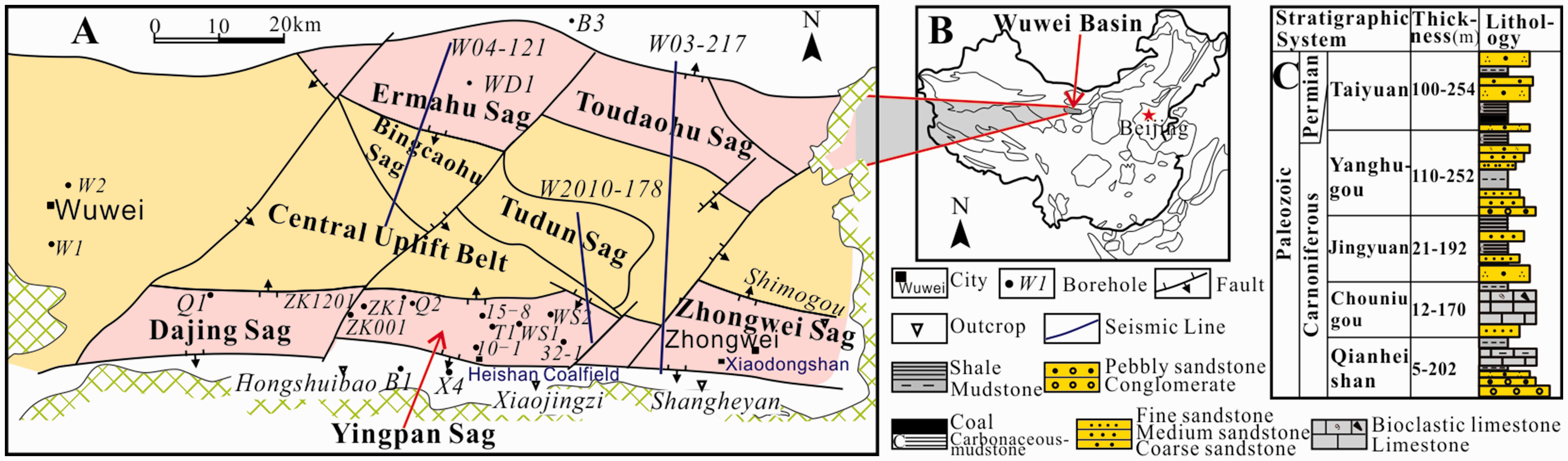
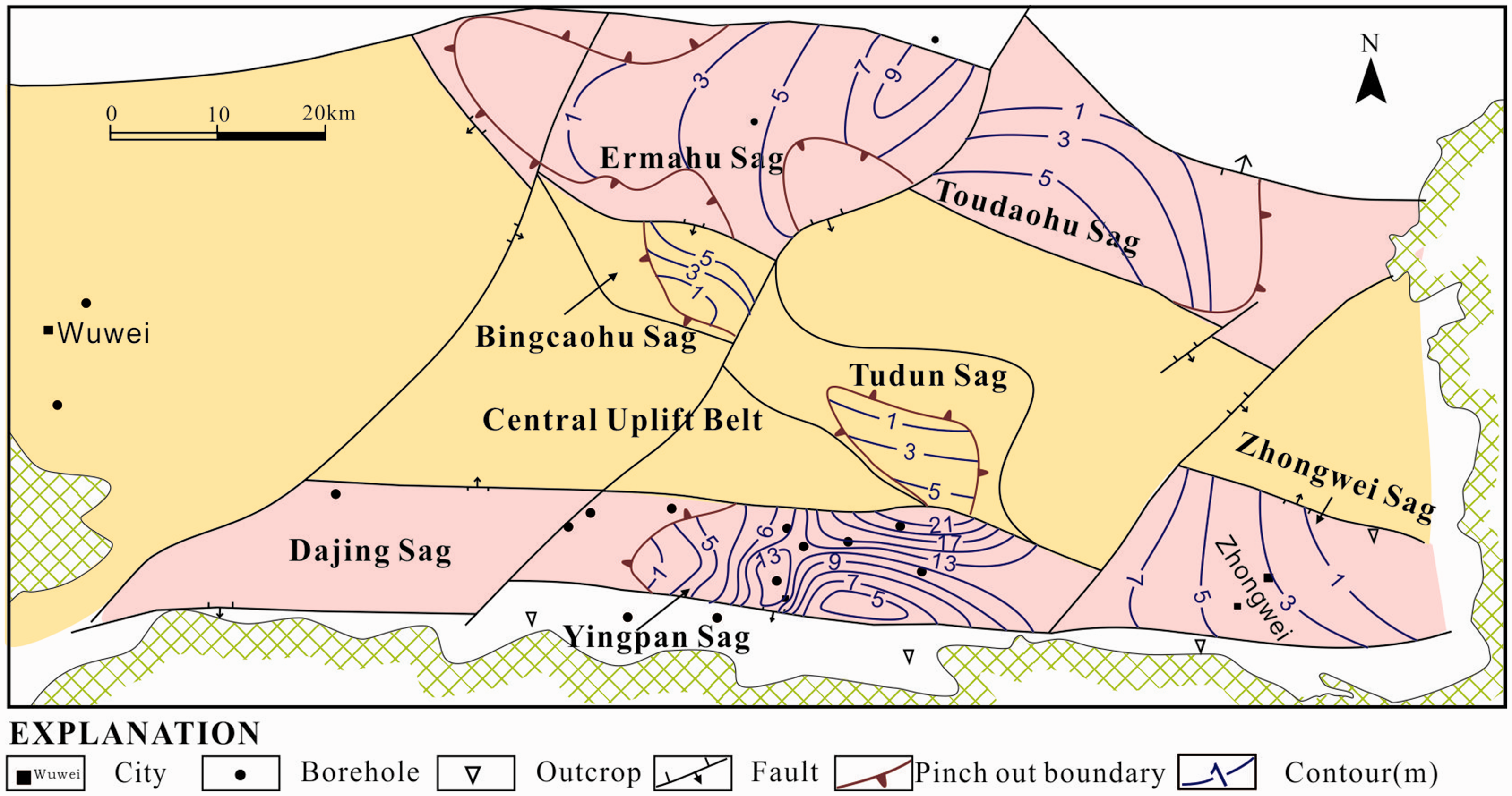
A: a map showing the tectonic units of the Wuwei Basin; B: location of the study area; B: the Carboniferous to Early Permian stratigraphic section of the study area.
Geological setting of the Wuwei Basin
Tectonic setting
Numerous studies have described the geological setting, stratigraphy, and tectonic evolution of the Wuwei Basin (Wang, 2012; Wu, 1965; Yang, 1987). The Wuwei Basin belongs to the fold belt of the North Qilian Mountain, which is bounded by the North China Plate to the east, the Qinling fold belt to the south, and the Alxa Plate to the north (Wan, 2011). The structural features present in the basin were the result of the main tectonic events, namely the Late Paleozoic Hercynian, Triassic Indosinian, Jurassic-Cretaceous Yanshanian, and Cenozoic Himalayan tectonic events (Wan, 2011; Wang et al., 2007). The first event provided the basic conditions for the formation of the basin. The three subsequent events resulted in the formation of the present east-west trended and the northeast-southwest trended structural features and the depressions to the north and south.
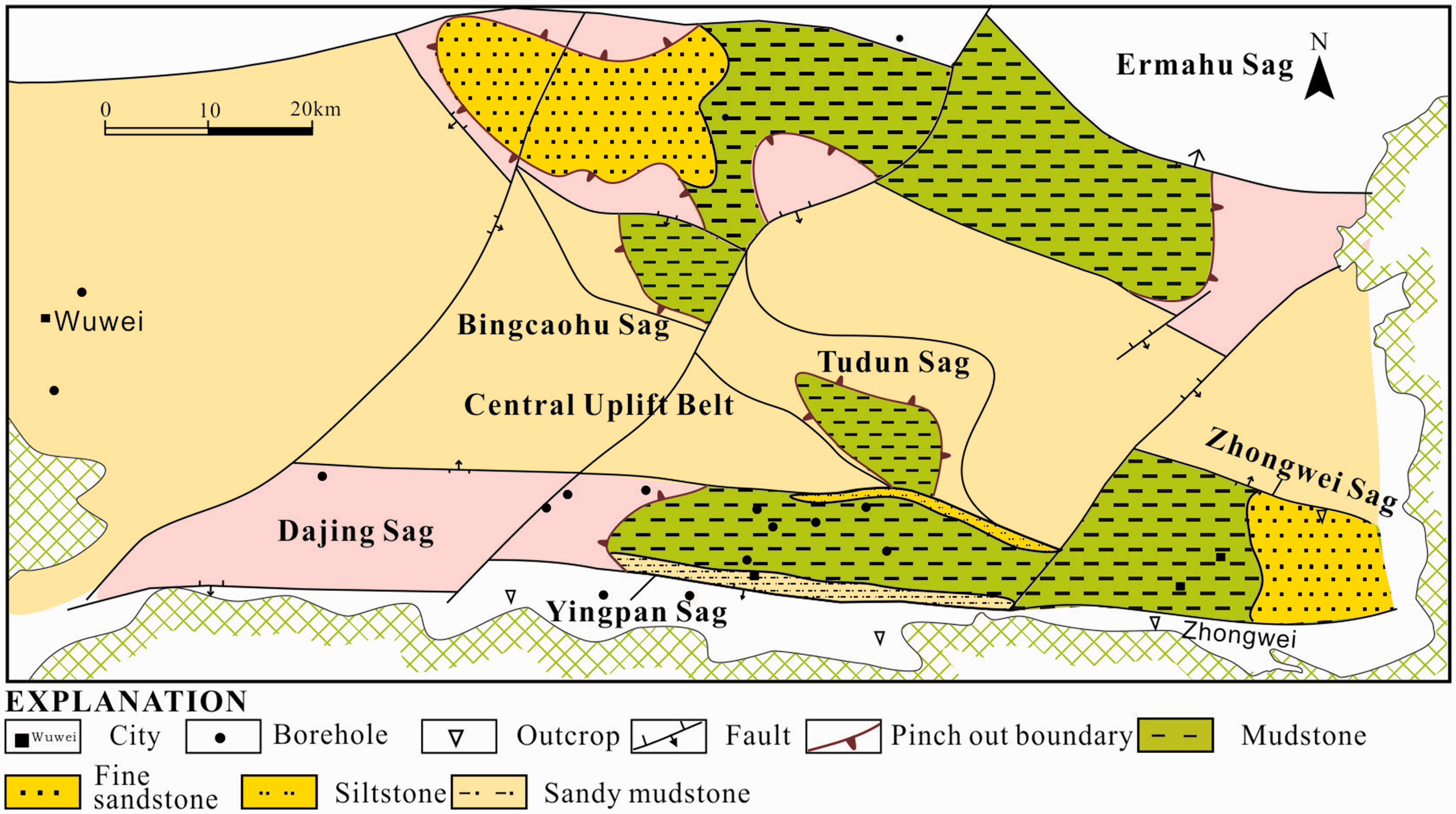
The Wuwei Basin can be subdivided into three secondary structural units from north to south, i.e., the Southern Depression containing the Dajing Sag, Yingpan Sag and Zhongwei Sag; the Central Uplift Belt including the Bingcaohu Sag and Tudun Sag; and the Northern Depression containing the Ermahu Sag and Toudaohu Sag (Figure 1(a)).
Coal-bearing strata
The Carboniferous and Early Permian sediments of the Wuwei Basin comprise the Qianheishan, Chouniugou, Jingyuan, Yanghugou, and Taiyuan formations. The coal seams are found within the Yanghugou and Taiyuan formations and were formed during the Late Carboniferous and Early Permian. A generalized stratigraphy of the Carboniferous and Early Permian in the Wuwei Basin is shown in Figure 1(c). The sedimentary environments of the coal accumulation in the Taiyuan Formation include lagoon, tidal flat, and delta (Shen et al., 2018). The economically valuable coal seams were mostly in the Heishan and Xiaodongshan coalfields, which were situated in the Yingpan and Zhongwei sags, respectively.
Sample materials and methods
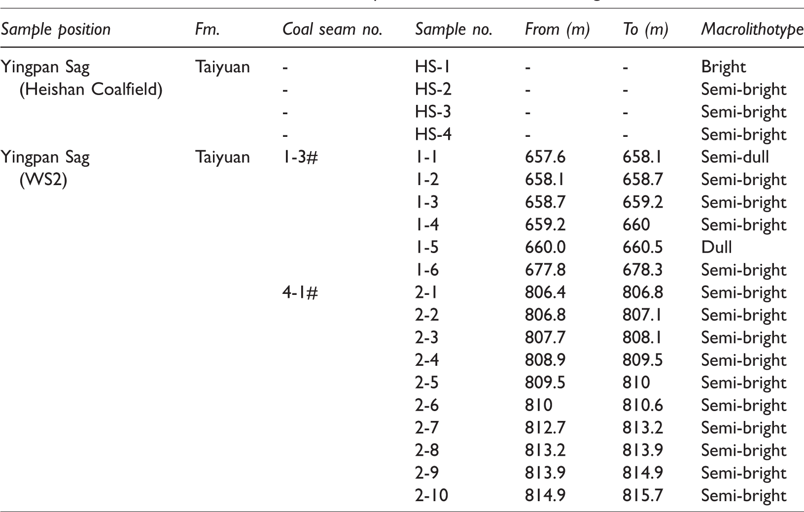
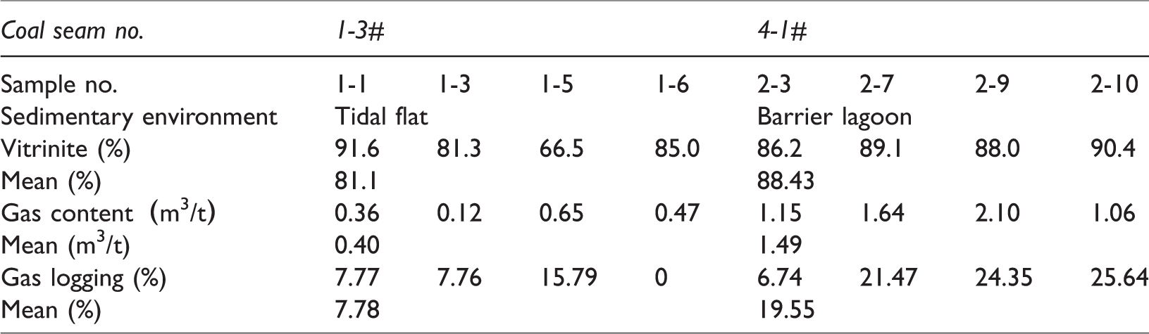
Sixteen samples were collected from the WS2 drilling cores; and they comprised six samples from the coal seam No. 1–3# (1–1 to 1–6) and 10 samples from coal seam No. 4–1# (2–1 to 2–10; Table 1). Four samples were collected from the Heishan Coalfield (Table 1). Based on a detailed sedimentological and facies analysis, the coal seam Nos. 1–3 and 4–1 were formed in the tidal flat and barrier lagoon, respectively.
Basic information on selected coal samples from coalfield and drilling cores.
The proximate analyses, including analysis of moisture content, ash yield and volatile content, were in accordance with the Chinese Standards GB/T 30732-2014, which correspond to the ISO 1171-1997 (1997), ISO 562-1998 (1998), and ISO 11722-1999 (1999). However, there were differences between the GB/T 30732-2014 and the above ISO standards, namely the determination of moisture content by the air-dry method was added, and the temperature was increased to 900 ± 10°C in 3 min and held for 7 min during the determination of volatile matter in the Chinese National Standard; however, the temperature was increased to 900 ± 5°C in 4 min for the ISO standard. Maximum vitrinite reflectance (Ro,max) and maceral analysis measurements were conducted on polished slabs of about 30 × 30 mm2; these analyses were performed by oil immersion in reflected optical light using a Leitz MPV-3 photometer microscope and the measurements were taken according to the Chinese Standards GB/T 6948-1998 and GB/T 8899-1998, respectively. The gas content data in this study were obtained from the test reports of the WS2 CBM exploration well. The gas content determination was corrected to 20°C and one atmosphere pressure, and it was calculated as a sum of loss, desorption, and residual gas. The measurements were taken according to the Chinese National Standard GB/T 19559-2004. Desorbed gases from the canisters were volumetrically quantified and analyzed for gas composition (CH4, CO2, N2, C2H6, and longer-chain hydrocarbons). The gas component analysis was performed using the TRY/Y2011-001, and the measurements were taken according to the Chinese National Standard GB/T 13610-2003.
All samples were crushed and sieved to a size range of 0.18–0.25 mm (60–80 mesh), and 100–125 g were weighed for the moisture-equilibrium treatment that was conducted for at least four days. After these preparations, the methane adsorption capacity of moisture equilibrated samples was measured using an IS-300 Gas Adsorption Isotherm Instrument at 30°C and a maximum equilibrium pressure of 10 MPa, following Chinese Standard Method GB/T 19560-2004.
The data of the tectonic characteristics, coal thickness, burial depth, roof lithology, and hydrogeology were collected from field test, coalfield prospecting reports, and related literatures (Shen et al., 2018; Wang, 2012; Wang et al., 2007).
Results and discussions
Characteristics of the coal reservoir
Coal rank
The coals in the Taiyuan Formation were mainly bituminous coal, and the Ro,max ranged from 0.70% to 1.25% (Table 2). In the Southern Depression, the Ro,max in the Yingpan Sag was increased from west to east, and the Ro,max in the Zhongwei Sag increased from the north to south (Figure 2). In the Northern Depression, previous studies revealed that the rank of the coals in the Well WD1 ranged from 0.74% to 0.97% (Du et al., 2017; Lu, 2009). In general, the Ro,max had a positive relationship with the burial depth of the coal seam in the study area. Based on the coal burial depth in the Northern Depression (Figure 8), it could be inferred that the Ro,max ranged from 0.60% to 1.00%.
Maceral composition, maximum vitrinite reflectance, and macrolithotype of the coal in the Wuwei Basin.
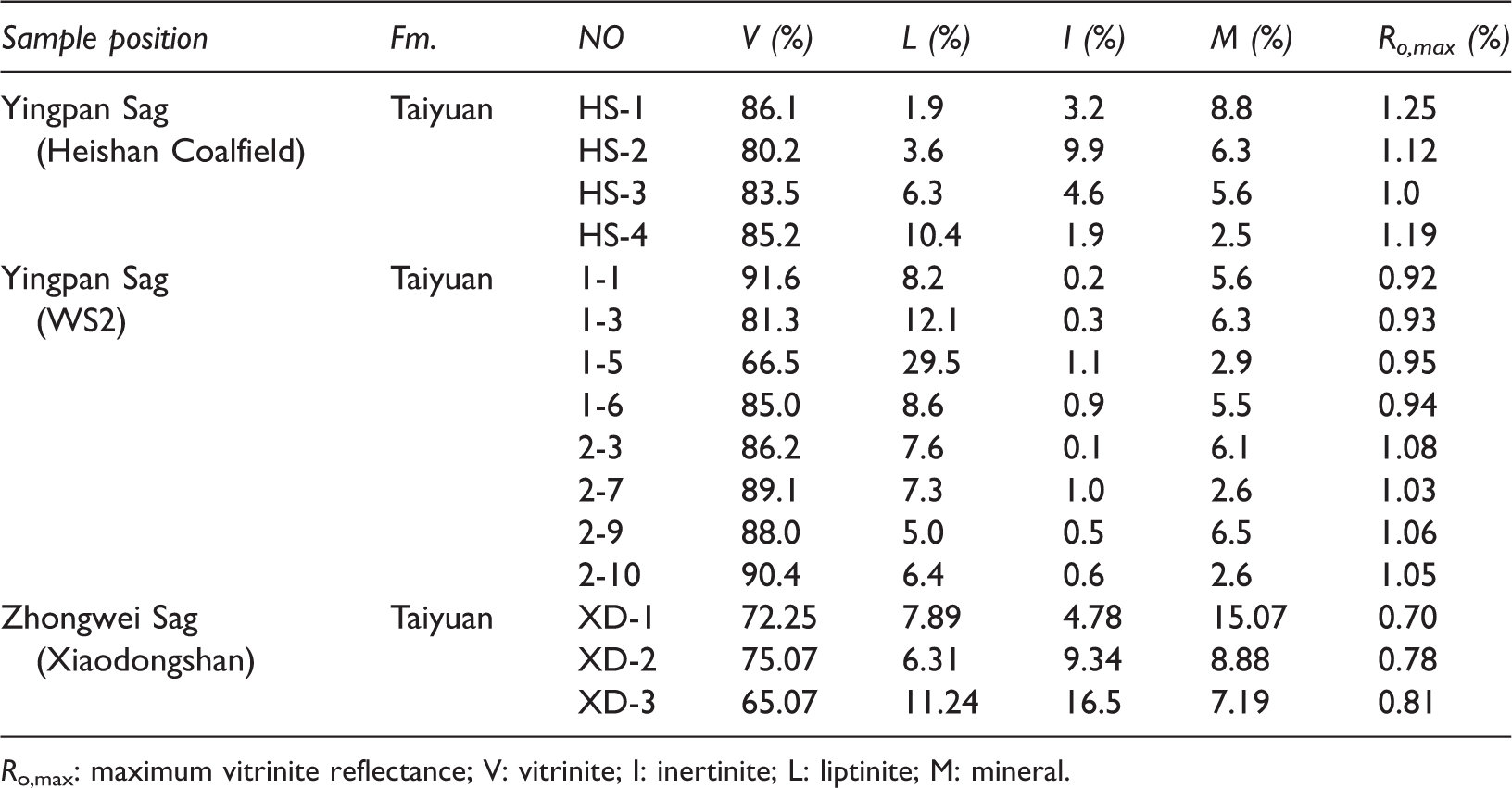
Ro,max: maximum vitrinite reflectance; V: vitrinite; I: inertinite; L: liptinite; M: mineral.
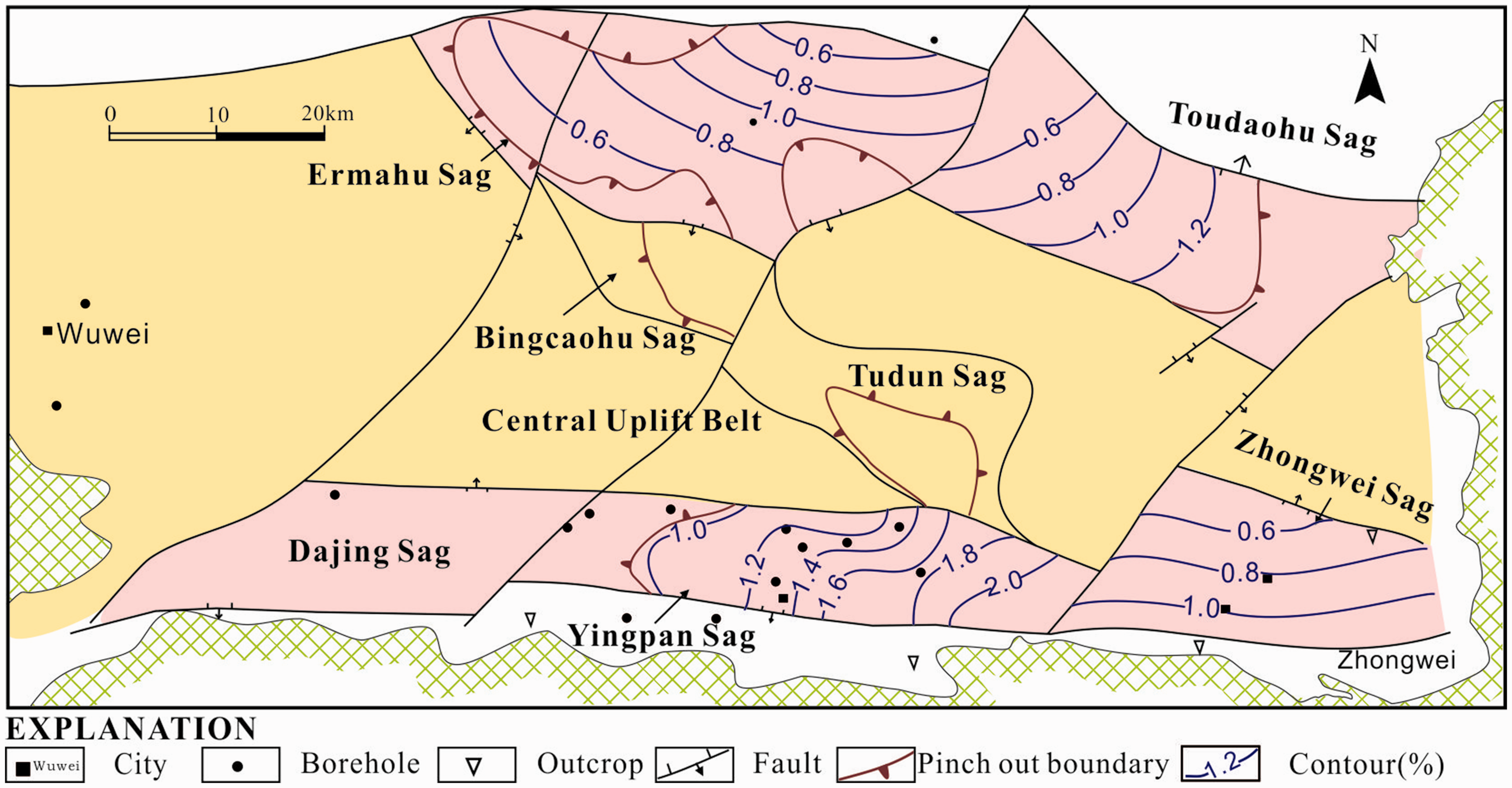
The contour map Ro , max of the coals in the Taiyuan Formation in the Wuwei Basin.
Coal petrology and quality
The macrolithotypes of coal samples in the Wuwei Basin were dominated by the semi-bright coal (Table 1). As shown in the Table 2, the coals in the Taiyuan Formation were characterized by abundant vitrinite, which ranged from 65.07% to 91.6% (averaged 81.70%), relatively high contents of liptinite (averaged 8.82%) and low inertinite contents (averaged 3.66%). Mineral contents varied from 2.50% to 15.07% (averaged 6.16%). The methane adsorption capacity of vitrinite and inertinite is greater than that of liptinite with equal amounts (Alexeev et al., 2004; Chalmers and Bustin, 2007). In general, vitrinite-rich coals have a stronger methane adsorption capacity than inertinite-rich coals (Hildenbrand et al., 2006; Laxminarayana and Crosdale, 2002; Scott et al., 2007). From the results of macrolithotypes and macerals, our preliminary conclusion was that the Taiyuan Formation coals were favorable for the formation of CBM.
Detailed analyses of approximately 20 coal samples were conducted in the Huabei Oilfield Exploration and Development Research Institute. The suite tests included measurement of moisture, ash content, volatile matter, fixed carbon, and total sulfur content. Coal proximate characteristics of the Taiyuan Formation coal are given in Table 3. The moisture content ranged from 0.90% to 4.15% (averaged 1.38%) and decreased with depth in the WS2. Average ash content (dry basis), volatile matter, and fixed carbon for coals in the Heishan Coalfield and WS2 were 22.81%, 26.86%, and 54.11%, respectively. Coal sample Nos. 1–1 to 1–6 were formed in tidal flat, and sample Nos. 2–1 to 2–10 were formed in the barrier lagoon. The ash yield in the tidal flat (averaged 26.8%) was clearly higher than that in the barrier lagoon (averaged 18.30%; Table 3). In general, the coal exhibited a relatively constant moisture content, ash yield, and total sulfur content. However, the ash content varied in different coal samples. It belongs to low-medium ash yield and high sulfur coal. The relationship between gas content and coal quality will be discussed in “Gas content” section.
The statistics of coal proximate analysis in the Wuwei Basin.
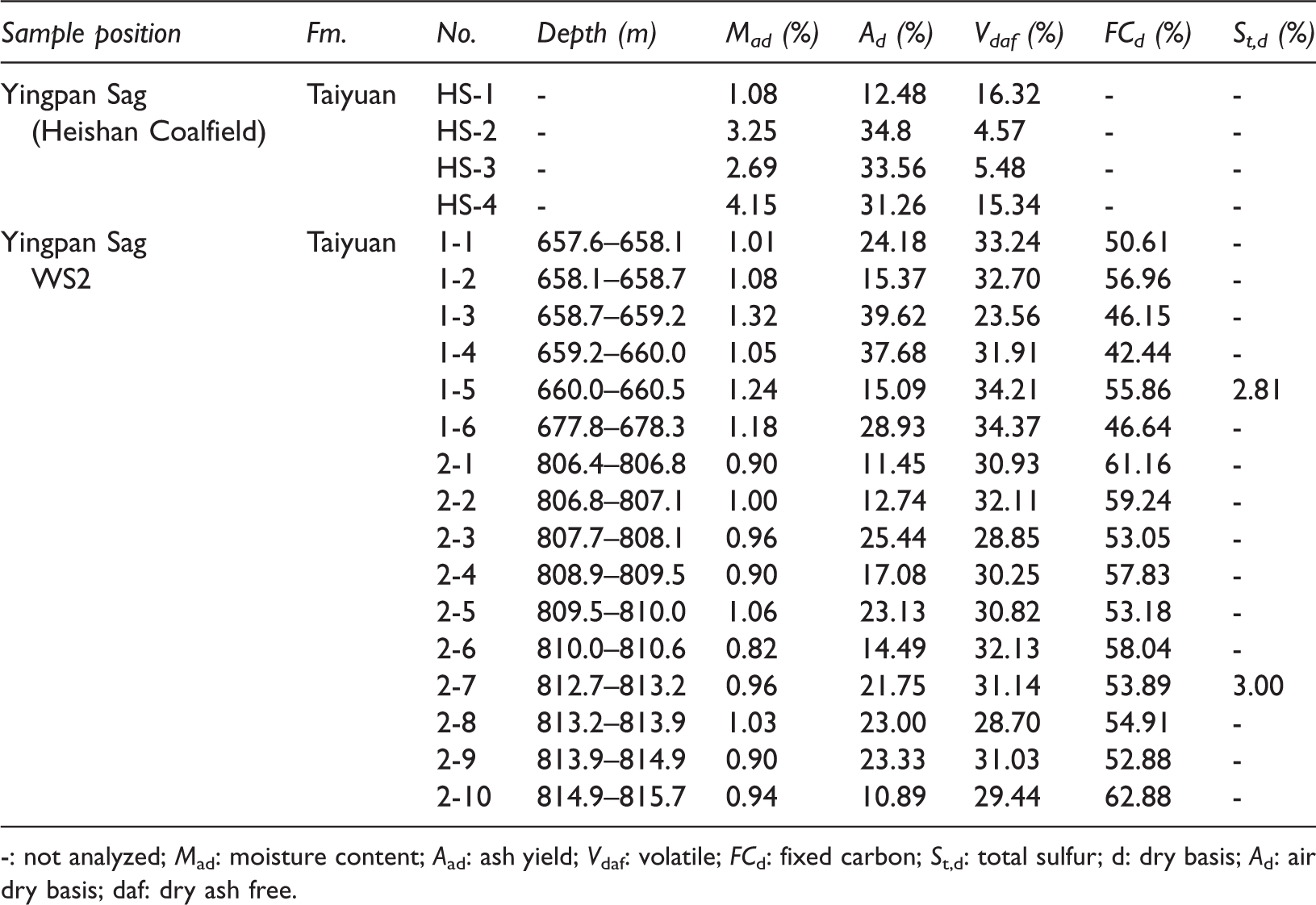
-: not analyzed; Mad: moisture content; Aad: ash yield; Vdaf: volatile; FCd: fixed carbon; St,d: total sulfur; d: dry basis; Ad: air dry basis; daf: dry ash free.
Gas composition, coal adsorption capacity, and gas content
Gas composition
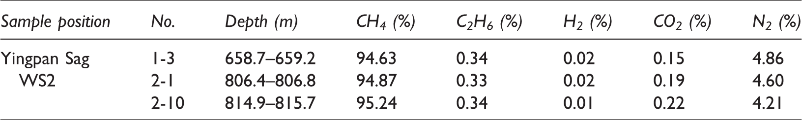
The gas quality refers to the types of gases inherently present in the reservoir, which is represented by the composition of the gas (Moore, 2012). Gases in the CBM reservoir were characterized by a high percentage of CH4, which ranged from 94.63% to 95.24% with an average of 94.91% (Table 4). The dataset collated for this study field showed that the gases are high in CH4, with accessory N2 (4.56%), rare C2H6 (0.34%), CO2 (0.19%), and H2 (0.017%; Table 4). Gases in a CBM reservoir can be divided into two groups, namely productive gases (CH4, C2, C3, etc.) and inert gases (CO2, N2, and H2S); the productive gases are considered indicators of economic value (Moore, 2012). The productive gases (CH4, C2H6) are dominated in the CBM reservoir, which determined economical values of the gas in the Wuwei Basin.
The gas composition of desorbed gas of the Well WS2 in the Wuwei Basin.
Coal adsorption capacity
Adsorption isotherm experiments are the most commonly used to understand CBM reservoirs. It is essential to estimate the amount of gas that the reservoir is capable of holding (Diamond and Schatzel, 1998; Meng et al., 2014; Moore, 2012; Perera et al., 2012; Zang and Wang, 2017). The Langmuir isotherm model is the most widely used model for adsorption and desorption tests of methane in the coal (Guo et al., 2015; Jian et al., 2015; Meng et al., 2014; Perera et al., 2012; Wang et al., 2014). The results of methane adsorption isotherm experiments of four samples showed that the coals in the Yingpan Sag of the Wuwei Basin had low to moderate adsorption capacities (Table 5, Figure 3), with the air dried (ad) and dry ash-free (daf) Langmuir volumes (VL, maximum adsorption capacity) ranging from 7.48 to 19.01 m3/t (average of 10.84 m3/t) and 8.31 to 23.35 m3/t (average of 12.93 m3/t), respectively. The air-dried Langmuir pressure (PL) ranged from 2.82 to 5.55 MPa (average of 4.64 MPa).
Results of methane isothermal adsorption measurements of Taiyuan Formation coal seam in the Wuwei Basin.
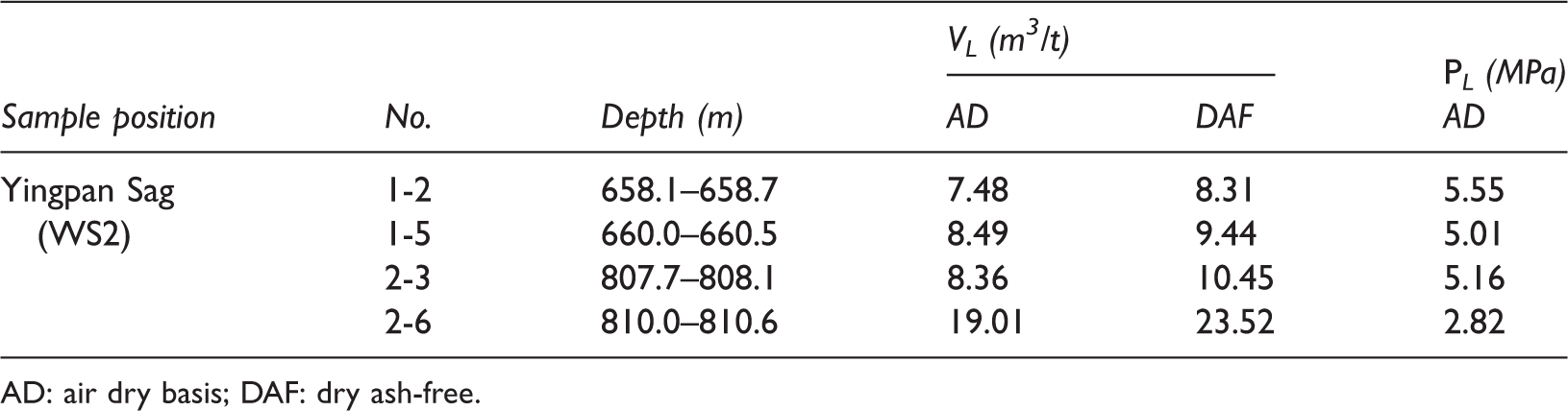
AD: air dry basis; DAF: dry ash-free.
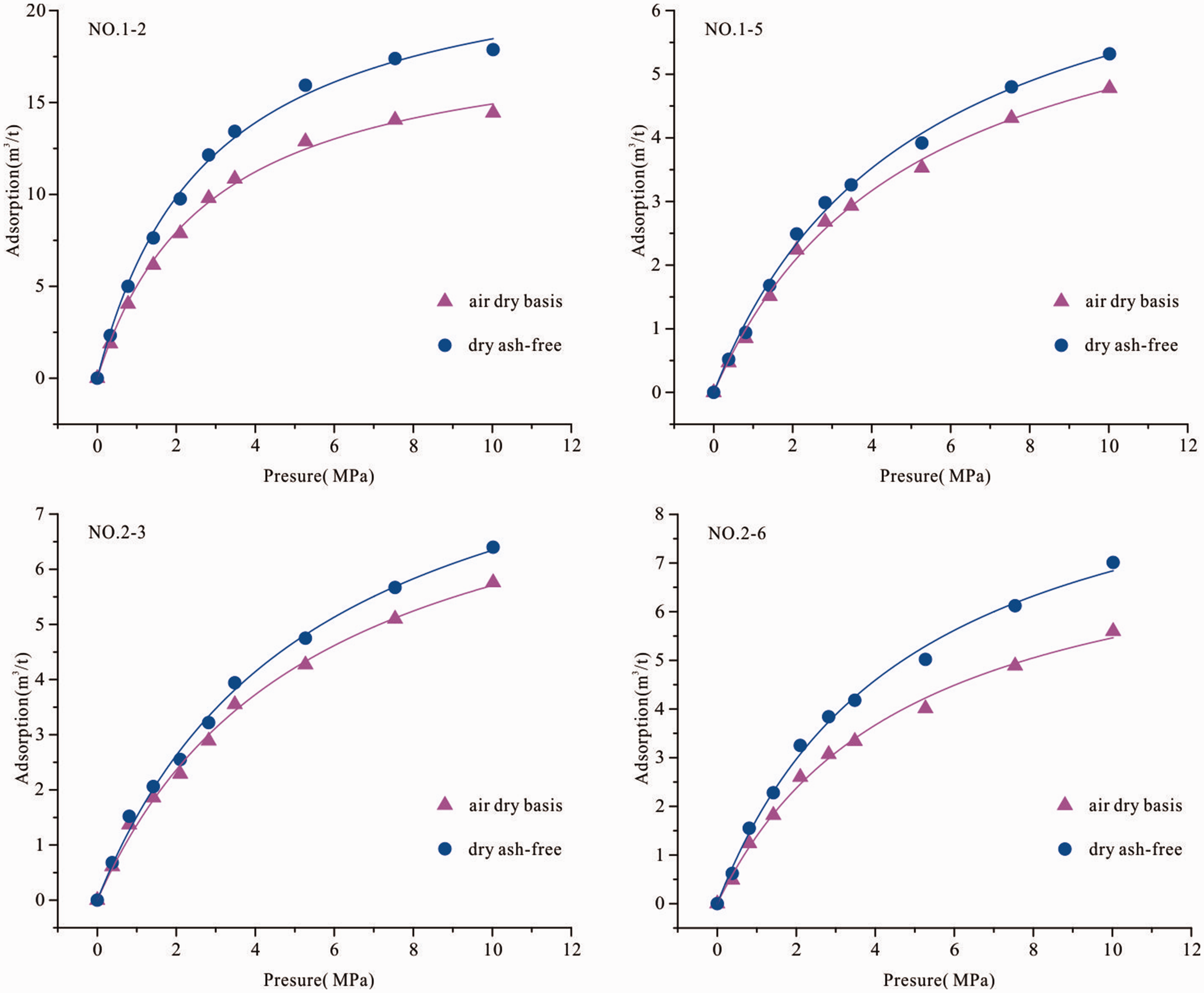
Isothermal adsorption curves of coals in the Taiyuan Formation of the Yingpan Sag, Wuwei Basin.
Gas content
The gas content can be obtained using the direct methods and indirect methods (Diamond and Schatzel, 1998; Moore, 2012; Perera et al., 2012). The gas content of the coal includes the loss, measured and residual gas. The amount of measured gas in the coal was estimated by taking a sample of fresh coal and desorbing the gas over a period of time (6.99 to 31.64 d). The gas content ranged from 0.28 to 4.14 m3/t (Table 6). The coal samples were deformed in the WS2; the physical and chemical texture of coals had been changed. This could underestimate the amount of the lost gas (Ju et al., 2009). Therefore, the gas content obtained using the direct methods does not necessarily result in accurate in situ gas content values.
Gas content of CBM exploration WS2 borehole of Yingpan Sag in Wuwei Basin.
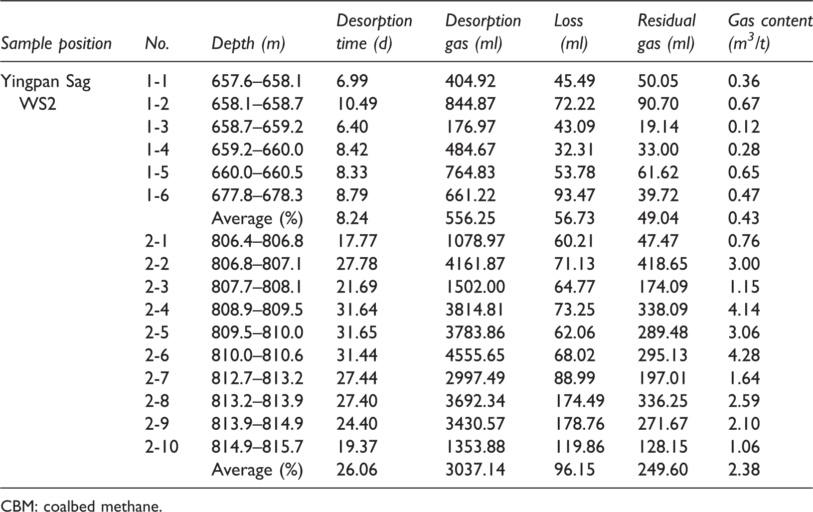
CBM: coalbed methane.
The gas content can also be estimated indirectly based on absorption isotherm data (Diamond and Schatzel, 1998; Mavor et al., 1990; Moore, 2012). A previous study showed that the CBM reservoir pressure gradient was 11.01 kPa/m (Liu, 2015). Based on the sorption isotherm data, the reservoir pressure gradient, and temperature, the average theoretical gas contents of the coal seams in the Taiyuan Formation were 7.25 m3/t. However, the isotherm-based methods may overestimate the actual gas content; these theoretical gas contents are commonly used for resource assessment when the study area is in lack of the gas contents data. The indirect methods indicated that the Wuwei Basin could be a target area for commercial CBM exploration.
The trend in the gas content was an increase from upper to lower (Table 6). The gas content was related to the inorganic material, moisture, roof lithology of the coal (see “The type of coal roof lithology” section). The relationship of gas content with moisture content and ash yield has a moderate to weak inverse relationship (Figure 4), indicating the association of coal seam with organic constituents. These results are consistent with the previous studies in other areas (Bustin and Clarkson, 1998; Lamberson and Bustin, 1993; Ozdemir and Schroeder, 2009).
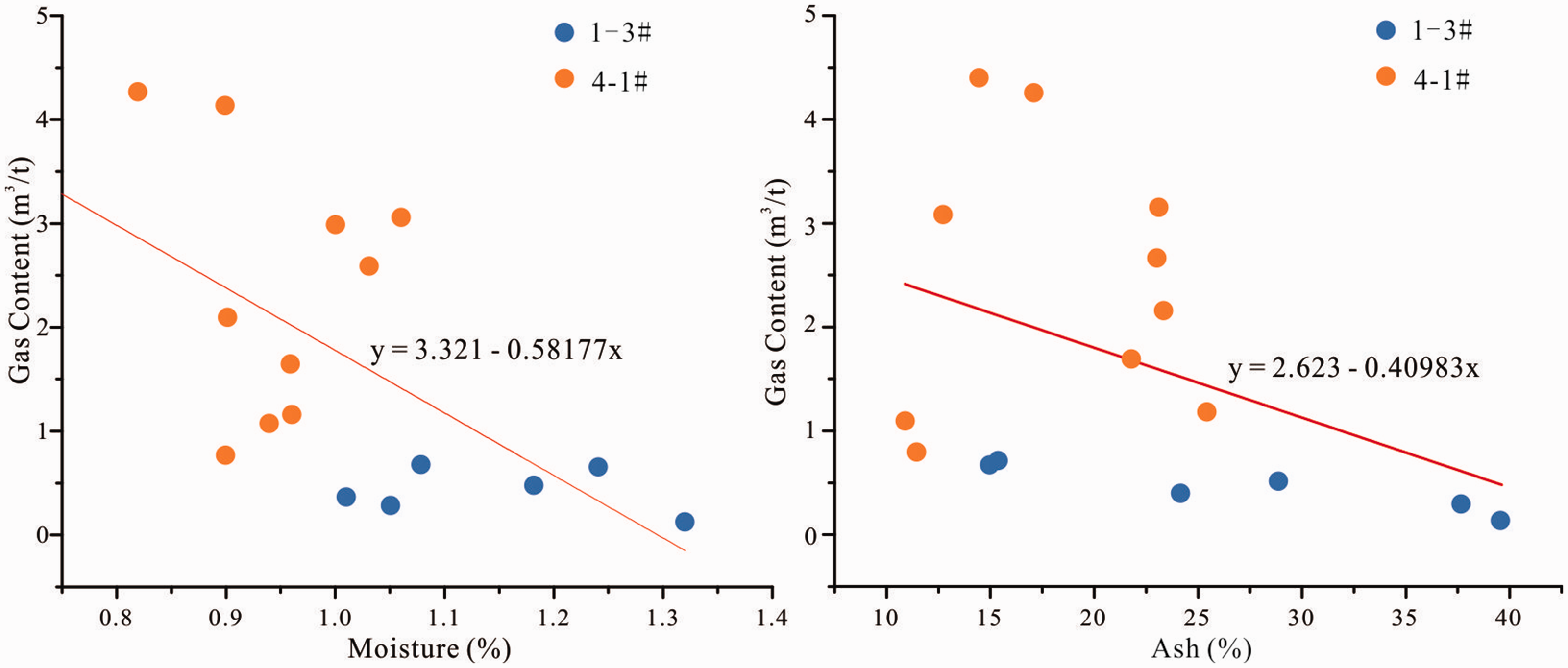
Relationship between the gas content and moisture and ash contents for the coals in the Taiyuan Formation of the Yingpan Sag, Wuwei Basin.
The value of gas logging ranged from 1.35% to 31.21% (averaged 12.86%) in WS1 and 0.65% to 25.64% (averaged 8.16%) in WS2 (Figure 5). Clearly, the value of the gas logging in the barrier lagoon was higher than that in the tidal flat. Combining the results of the relationship between coal quality and the sedimentary environment, gas logging and the sedimentary environment, gas content and coal quality, we concluded that the gas holding capacity of the coals formed in the barrier lagoon was higher than that of coals formed in the tidal flat (Table 7).
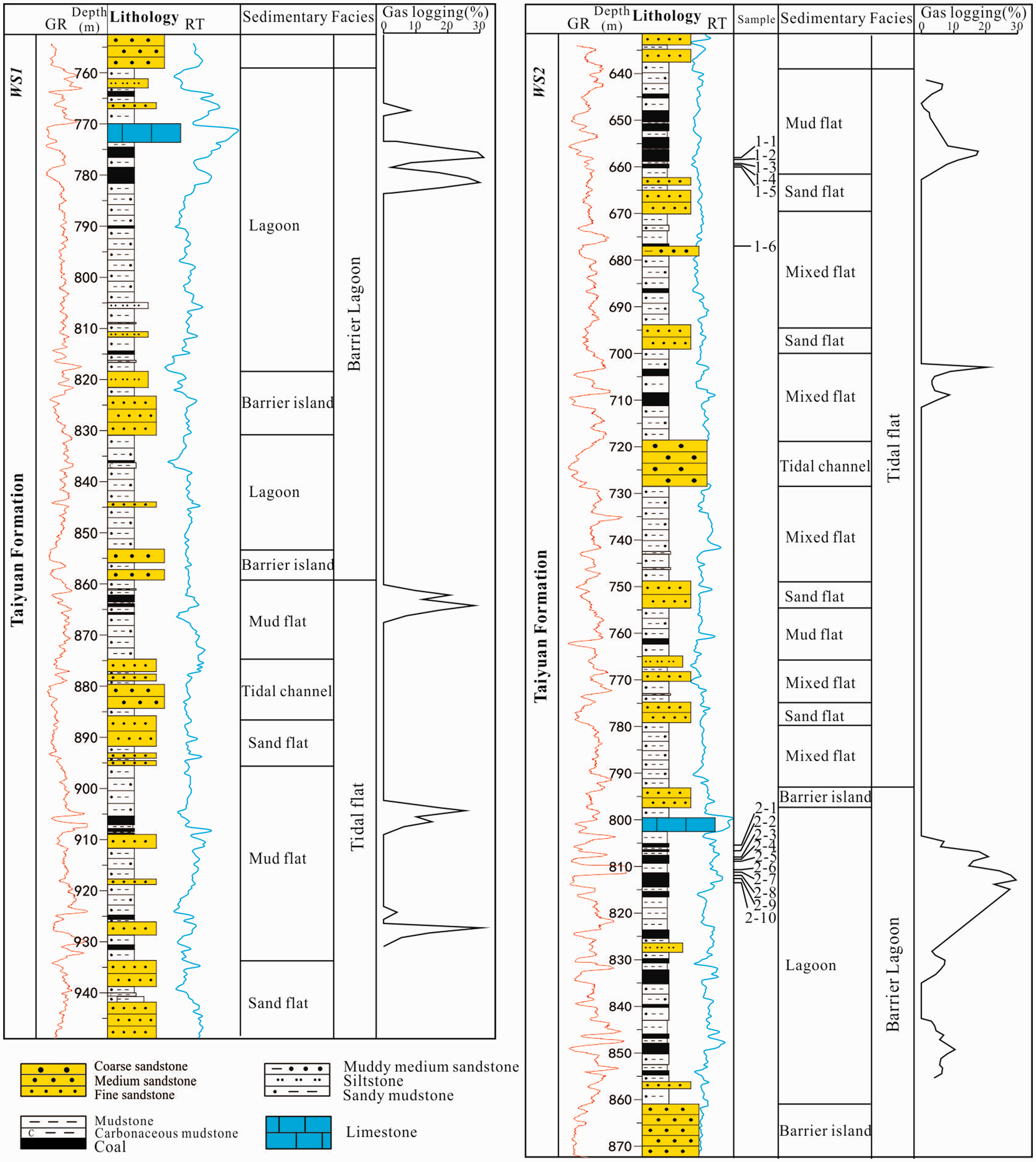
The sedimentary facies and the coal gas logging of the Taiyuan Formation in the Wells WS1 and WS2 in the Yingpan Sag, Wuwei Basin.
The results of the vitrinite, gas content, and gas logging in different sedimentary environments.
Impact of the original sedimentary environment
The depositional setting in which peat forms will naturally affect the thickness, distribution, and roof lithology of a coal seam (Ayers, 2002).
Development of the coal seam
Reconstruction of the paleogeography is an excellent tool for the prediction of development of the coal seam (Shao et al., 2003). The sedimentary environments of coal-bearing strata included delta plain, lagoon, and tidal flat in the Wuwei Basin (Figure 6). In the Northern Depression, the dominant environments were tidal flat and lagoon. The sedimentary environments in the Southern Depression were mainly delta. In the Ermahu Sag, Toudaohu Sag, Bingcaohu Sag, and Tudun Sag with less or nonexistent borehole data, we combined the paleogeography which was reconstructed by Shen et al. (2018), with the principle of coal accumulation in the tidal flat, lagoon, and delta environments to predict the coal seam distribution in these areas.
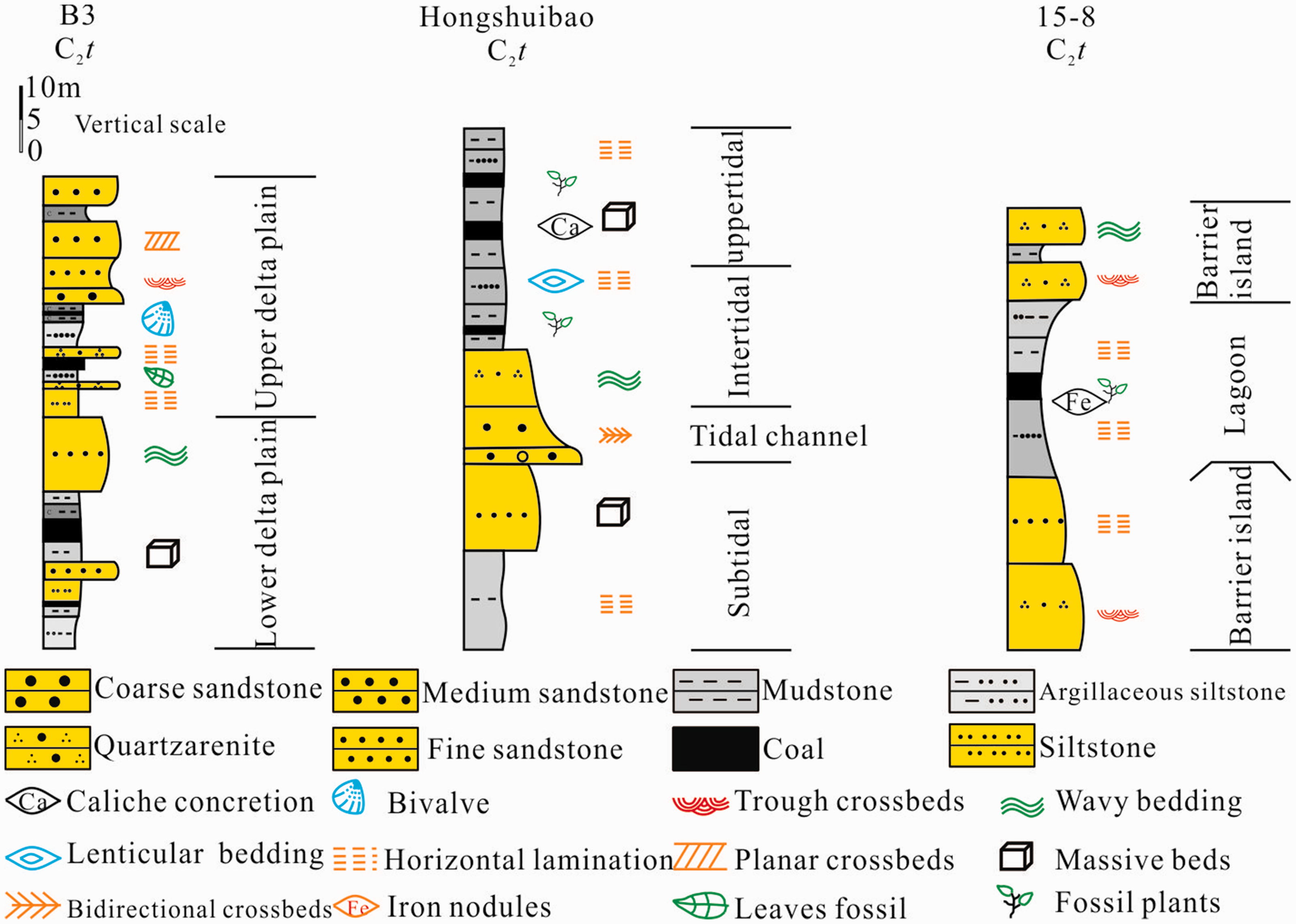
The typical coal-bearing sedimentary facies of the Taiyuan Formation in the Wuwei Basin.
Figure 7 shows the distribution of the Taiyuan Formation coal seam. The main coal accumulation center was located at the Yingpan Sag, followed by the Ermahu Sag. The coal seam was distributed in an east-west trend, and the thickness varied from 1 to 21 m in the Yingpan Sag. Due to the effects of the fold and fault, there were significant differences in the distribution of the coal seam. The coal seam was distributed in a north-south trend and the thickness varied from 1 to 7 m in the Zhongwei Sag. The prediction results of the coal seam thickness of the Ermahu Sag, Toudaohu Sag, Bingcaohu Sag, and Tudun Sag are shown in the Figure 7. Therefore, we predicted that the thick coal belt was located in the northern area of the Ermahu Sag and that the coal seam thickness varied from 1 to 9 m. The sedimentary environment of the Toudaohu, Bingcaohu and Tudun sags were dominated by subtidal and littoral-neritic sea, which was unfavorable for the coal seam accumulation. The thickness of coal seam in these sags is thin and varied from 1 to 5 m.
The contour map showing coal seam thickness of the Taiyuan Formation in the Wuwei Basin.
Considering the borehole data and seismic profile (Figure 8), we obtained the results of burial depth of Taiyuan Formation coal seams. The results showed that the burial depth of the coal seam varied from 400 to 1400 m (Figure 9), and that the depth of the coal seam was mainly controlled by the tectonic conditions and paleotopography. The burial depth of the coal seam in the Northern Depression became shallower from the hinterland to the margin, and the depth of the coal seam ranged from 800 to 1400 m. The burial depth of the coal seam in the Bingcaohu Sag ranged from 600 to 800 m. The coal seam burial depth in the Tudun Sag varied from 400 to 600 m. The burial depth of the coal seam in the Southern Depression gradually deepened from west to east, and the burial depth of the coal seam ranged from 400 to 1100 m. According to the depth boundary of the deep CBM in China (>1000 m; Zhao and Qin, 2010), these CBM resources were buried shallow (<1000 m) and beneficial for development. The CBM resources in the Yingpan Sag were the most favorable for economic development.
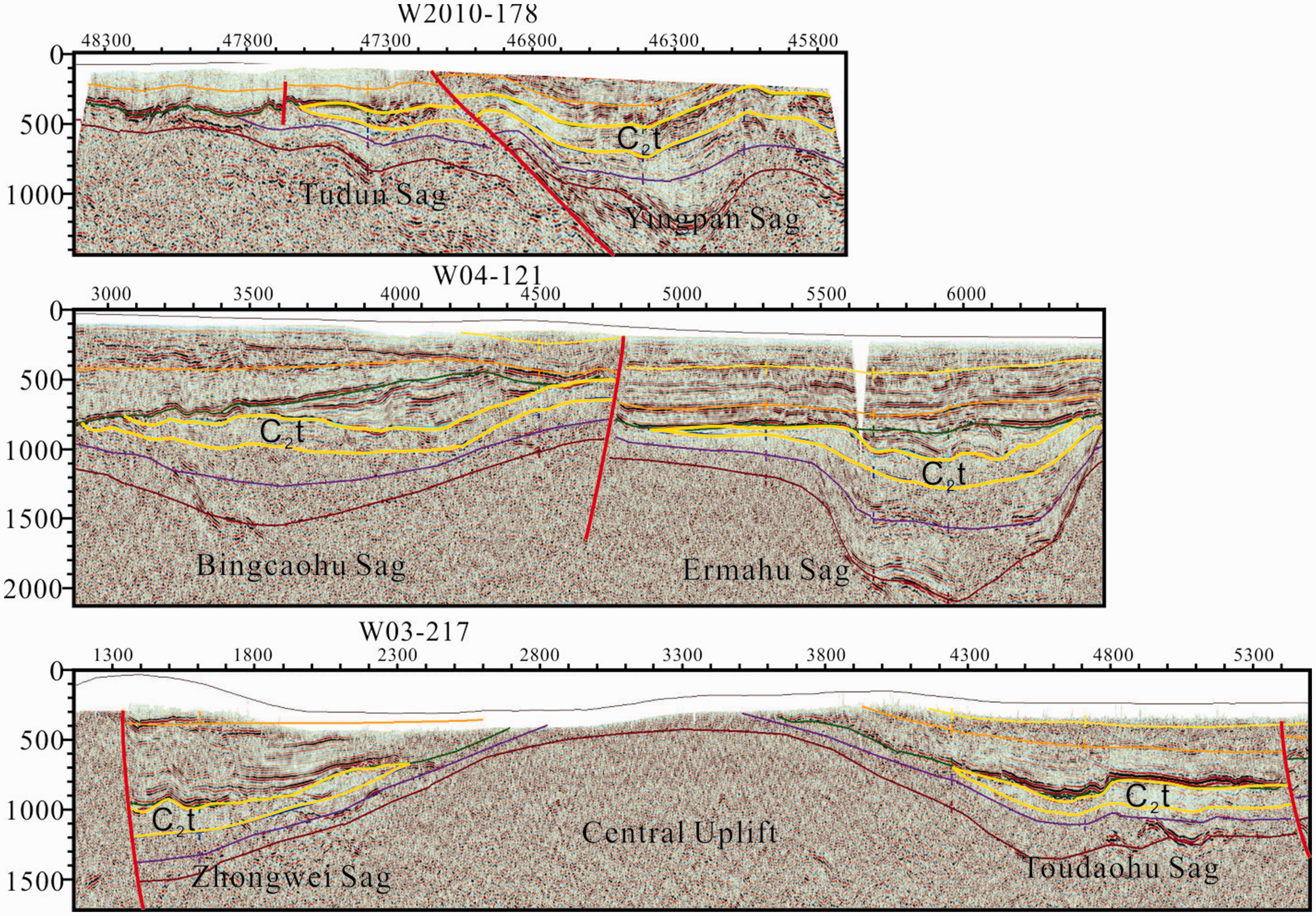
The profile of seismic lines in the Wuwei Basin, the area labeled as C2t and highlighted by the yellow line indicates the Taiyuan Formation.
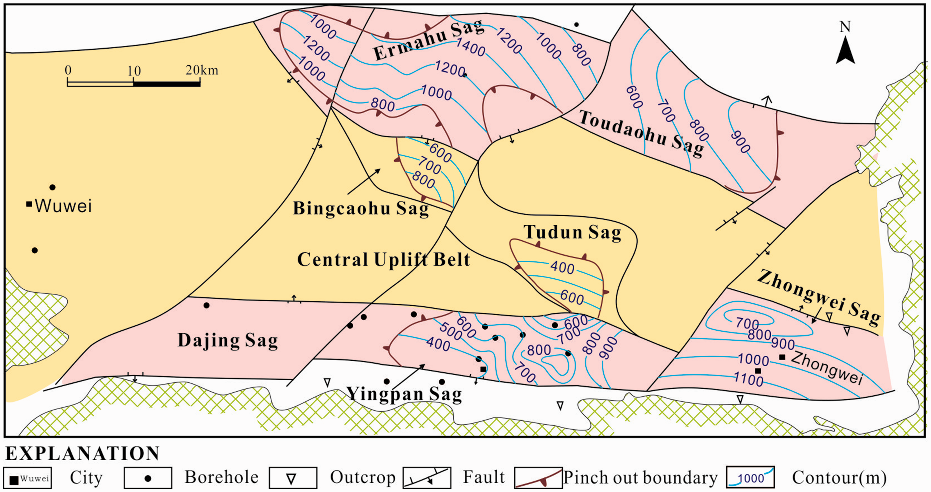
The contour map showing burial depth of coals in the Taiyuan Formation of the Wuwei Basin.
The type of coal roof lithology
The lithological association of the coal-bearing strata is important for the preservation and enrichment of CBM. The sealing ability is adequate with the high content mudstone or tight sandstone (Bustin and Clarkson, 1998; Grimm et al., 2012).
The sedimentary environments of the Taiyuan Formation coal include tidal flat, lagoon, and delta. In the barrier coast depositional system, the coal seam is located in the middle and upper part, and the roof lithologies were characterized by mudstone and silty mudstone that were formed in the intertidal and lagoon. In the delta system, the coal seam is located in the lower and middle part, the roof lithology of the coal seam includes mudstone and siltstone that were formed in the distributary bay, distributary channel or crevasse. Based on the borehole data and distribution of the sedimentary environment, the roof lithologies of the Taiyuan Formation coal seam were mainly dominated by the mudstone (Figure 10). Mudstone could be an effective sealant and prevent diffusion of CBM. To summarize, the lithological association of the coal seam roof was beneficial for CBM preservation in the Wuwei Basin.
The map showing lithologies distribution of the roof of the major coal seams in the Taiyuan Formation coal in the Wuwei Basin.
Role of structure
The structural evolution controls the sedimentary burial history and thermal evolution history of the coal-bearing strata. The geologic structure determines the shape, continuity, and permeability of coal; therefore, these factors are critical considerations for determining the distribution and production of CBM (Hou et al., 2012; Pashin and Richard, 1998).
During the Carboniferous to Early Permian, slow subsidence of the Late Hercynian resulted in the widespread deposition of the Carboniferous–Early Permian coal-bearing series throughout the whole basin. This period was important for the formation of coal (Shen et al., 2018; Wang et al., 2007). The coal seam was buried and the coal rank gradually increased, which was the main generation of CBM. During the late part of the Early Permian, the Wuwei Basin was influenced by the tectonic event of the Late Hercynian (Wang et al., 2007). The study area was uplifted and experienced erosion after the formation of the coal, which was reflected in the extensive unconformity between the Dahuanggou and Taiyuan formations. This process adjusted the CBM migration adjustment and resulted in emissions, and also affected the preservation of the CBM.
The Indosinian in the Early and Middle Triassic controlled the basin evolution (Wang et al., 2007). From the Late Hercynian to the Indosinian, the tectonic event in the Wuwei Basin was dominated by the subsidence. The subsidence rate rapidly was increased in the Indosinian. A large amount of fluvial and lacustrine facies clastic rock was deposited, and has a thickness of about 2000 m. The deepening of the coal seam burial depth had a positive impact on the formation of CBM.
In the early period of the Yanshanian tectonic event, the Wuwei Basin was affected by the collision of the southern Qiangtang Plate. Under the north-northeast extrusion stress, the study area was uplifted and the Mesozoic was eroded (Wang et al., 2007). Coal metamorphism and hydrocarbon generation were suspended in this period. The crustal stress was dominated by the extrusion in this period (Wan, 2011), and the amount of CBM emissions might have been small.
In the Late Himalayan, the Indian Plate was subducted to the Eurasian Plate, and the Qinghai-Tibet Plateau was uplifted (Wan, 2011). Due to the serious north-south extrusion, the north and north-northeast faults were formed. The faults that were formed in the Indosinian were reactive. In the Himalayan, some parts of the coal-bearing series were uplifted nearly to the surface. The coal-bearing strata were re-transformed and the CBM was lost in this period.
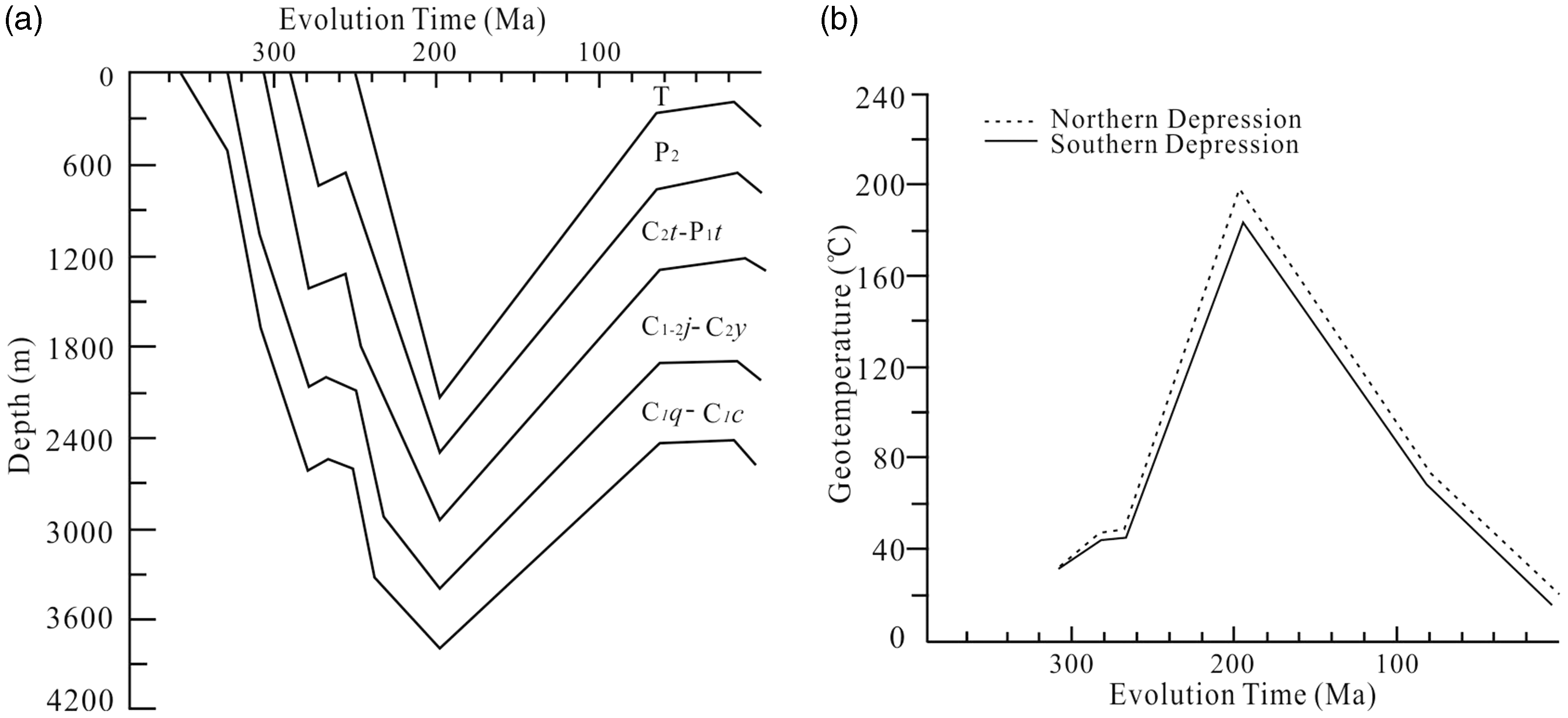
Figure 11(a) shows the coal seams burial history of the Taiyuan Formation. The maximum burial depth of coal-bearing strata was about 2500 m at the end of the Triassic. This also provided an opportunity for the formation of CBM. The reflection of the vitrinite could illustrate the evolution of the geo-temperature (Harris and Peters, 2012; Nádudvari and Fabiańska, 2016), Figure 11(b) shows the geo-temperature evolution in the different parts of the basin; the maximum geo-temperature ranged from 180°C to 190°C. Comparative analysis of the burial and hydrocarbon generation history of CBM between the Wuwei Basin and Qinshui Basin showed that the evolution process of the two basins was basically the same in the Late Carboniferous to Early Jurassic. However, these two basins showed different tectonic evolution processes from the Late Jurassic to Early Cretaceous. Due to the late tectonic thermal events of the Yanshanian Tectonic Event, the Qinshui Basin experienced a secondary hydrocarbon generation stage and produced a large amount of hydrocarbon gas during this period (Su et al., 2005). The Wuwei Basin was uplifted in this period, and lasted until the end of the Cretaceous. The different tectonic evolution processes resulted in a lower gas content in the Taiyuan Formation coal seam compared to that of the Qinshui Basin. In summary, the significant geological period for determining the CBM content in the Wuwei Basin was the Triassic to Cretaceous. The geological features of CBM in this area were formed early and modified later.
Tectonic evolution and thermal histories of the Wuwei Basin.
Influence of hydrogeological conditions
With gradually deepening exploration and development practice for CBM, the understanding of the importance of hydrogeological factors is also gradually improving. The hydrogeological impacts on CBM reservoirs are presented as the effect on CBM migration and enrichment under hydrogeological conditions (Fu et al., 2017; Li et al., 2015; Scott, 2002).
Based on the coalfield prospecting reports of the Heishan and Xiaodongshan coalfields, many sets of aquifers have been identified. The Quaternary aquifer, Permian aquifer, and Carboniferous aquifer are directly connected with the coal-bearing strata. These aquifers could have a closure or sealing action on the preservation of the CBM. An aquifuge existed in the upper and lower part of the coal-bearing strata of the Taiyuan Formation. The coalbed water was mainly recharged by glacier snowmelt from Qilian Mountain to the south, and the Quaternary aquifer and Permian aquifer could also recharge through the faults.
Water type and the total dissolved solids (TDS) values of coalbed water are always used to illustrate the water activity and have an effect on CBM preservation and enrichment (Li et al., 2015; Yao et al., 2014). The water types were characterized by Na, Mg, Cl-Ca, SO4 in the Yingpan Sag and Na, Cl-Ca, SO4 in the Zhongwei Sag (Table 8), which represented a relatively sealed hydrodynamic environment. The TDS values varied from 1.745 to 16.70 g/L. Moreover, the TDS values were higher in the Yingpan Sag than in the Zhongwei Sag. The high TDS values reflected the occluded hydrodynamic environment and were favorable for the preservation of CBM (Fu et al., 2017; Scott, 2002; Yao et al., 2014). The results showed that the hydrodynamic conditions in the Yingpan Sag were more favorable for the CBM preservation.
The chemical characteristics of coal measure ground-water in the Wuwei Basin.
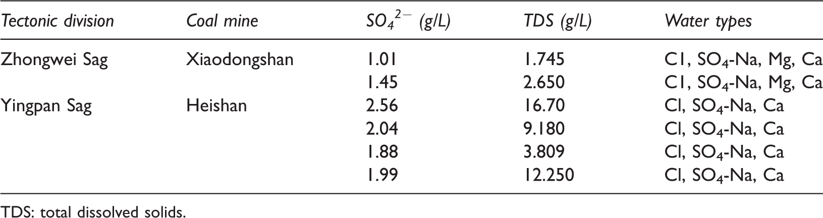
TDS: total dissolved solids.
Accumulation and enrichment models of the CBM
The synergistic interplay of the coal geology, sedimentology, structural geology, and hydrogeology controls the CBM accumulation and enrichment (Bustin and Clarkson, 1998; Cai et al., 2011; Kaiser et al., 1994; Moore, 2012). In the Wuwei Basin, gas accumulation is mainly affected by the sedimentary environments of the coal-bearing strata, structural factors, and hydrodynamic factors. Considering these factors, we proposed the following CBM accumulation and enrichment models for the Wuwei Basin.
The model of CBM enrichment in the broad syncline
The model of CBM enrichment in the broad syncline was mainly developed in the Ermahu Sag, which is made up of two reverse faults with opposite direction in the syncline wings. The sealed reverse faults were favorable for the CBM enrichment, and the overall preservation condition of CBM was better in the Ermahu Sag. Since there were not CBM exploration wells or hydrogeological data of the coal-bearing strata, the model of CBM accumulation was established by the comparison with a broad syncline enrichment model in the Qinshui Basin and Kaiping Coalfield (Luo et al., 2012; Su et al., 2005). Based on the seismic profile of the W04-121, it was determined that the coal-bearing strata were in direct contact with the Permian aquifer in the south of the sag. We inferred that ground-water of the coal-bearing strata was mainly recharged by the Permian aquifer. There were several hydrogeological units from south to north, and both were subdivided into the recharge area, runoff area, and stagnant area (Figure 12). The area of the sandstone roof, which was formed in the upper delta plain was the mainly recharge area of the coal-bearing strata. According to the available data and the broad syncline enrichment model of CBM, we inferred that the most favorable area with a gas-bearing property was positioned in the syncline core.
The model of CBM enrichment in the broad syncline in the Ermahu Sag of the Wuwei Basin.
The model of CBM enrichment in a gently sloping syncline
The model of CBM enrichment in a gently sloping syncline terminated by a marginal fault was mainly developed in the Zhongwei Sag and was composed of the reverse fault, which was explained from a seismic profile of W03-217. The structural framework was relatively simple. The ground-water of the coal-bearing strata was mainly provided by the atmospheric precipitation and supplied by the siltstone roof, which was formed in the upper delta plain. The Permian aquifer could also provide a water source through the area where the coal seam was directly connected to the Dahuanggou Formation in the northern part of the Zhongwei Sag (Figure 13). The hydrogeological units were subdivided into the stagnant area, runoff area, and recharge area from south to north. The Xiaodongshan Coalfield prospecting reports showed that the gas content of the Taiyuan Formation coal seam ranged from 0.90 to 5.86 m3/t. However, the coal seam thickness was thin and had poor value for CBM development in the Zhongwei Sag.
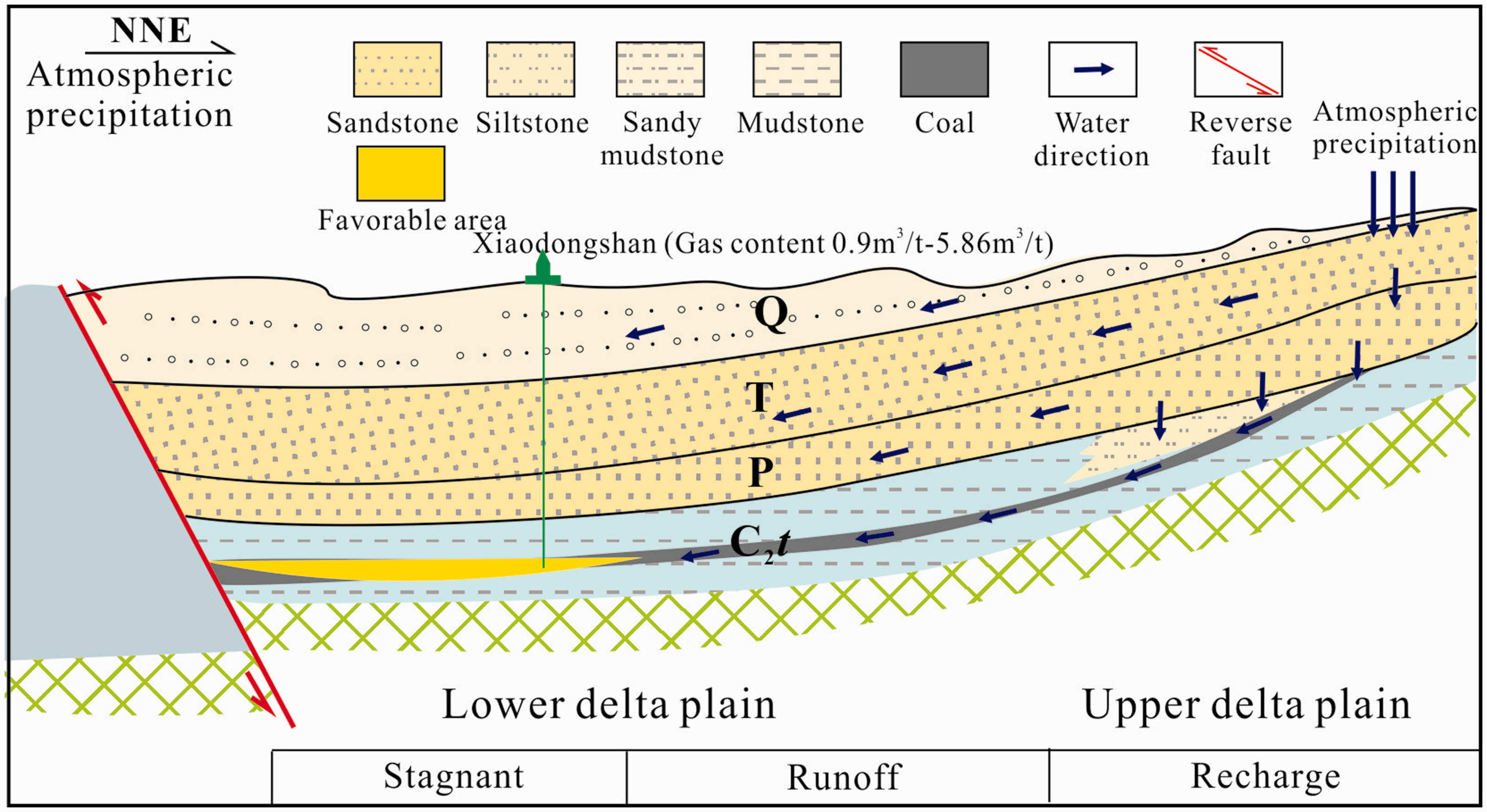
The model of CBM enrichment in a gently sloping syncline terminated by a marginal fault in the Zhongwei Sag of the Wuwei Basin.
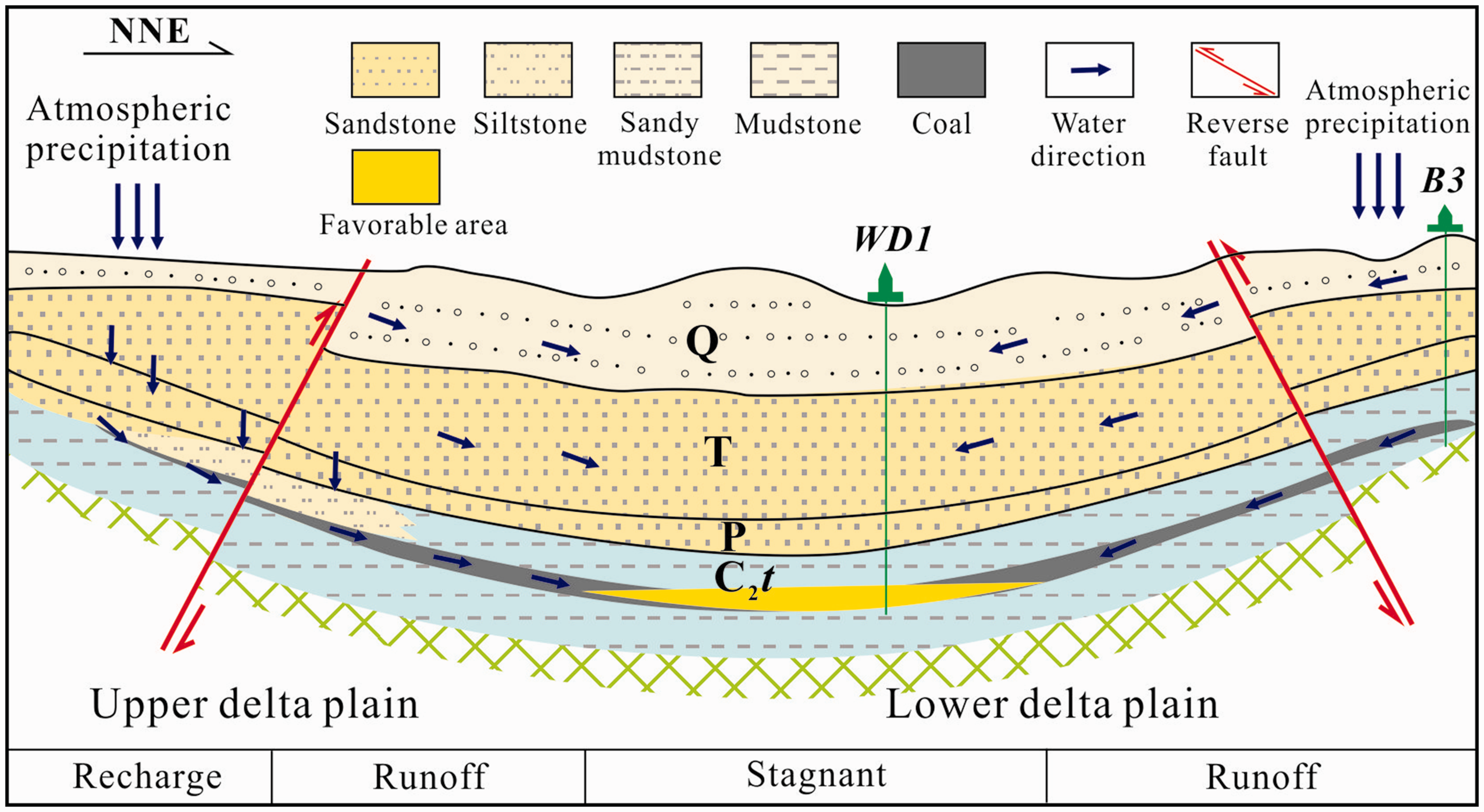
The model of CBM enrichment in the synclinorium
The structural framework of the Yingpan Sag was mainly composed of a synclinorium with a steep south wing and broad north wing, where the CBM enrichment was controlled by the hydrogeology, structure, and sedimentary environment of the coal-bearing strata. The hydrogeological units were complicated and subdivided into the recharge area, runoff area, stagnant area, runoff area, stagnant area, runoff area, and recharge area from south to north (Figure 14). The recharge area was mainly located in the southern part of the basin. The Permian aquifer replenished the ground-water of the coal-bearing strata through the sandy mudstone roof formed in the tidal flat environment and through the siltstone roof formed in the barrier environment. With the large TDS values, the stagnant area of the synclinorium was favorable for CBM enrichment. The gas content of WS2 ranged from 0.28 to 4.14 m3/t, so we inferred that the gas content in the stagnant area was greater.
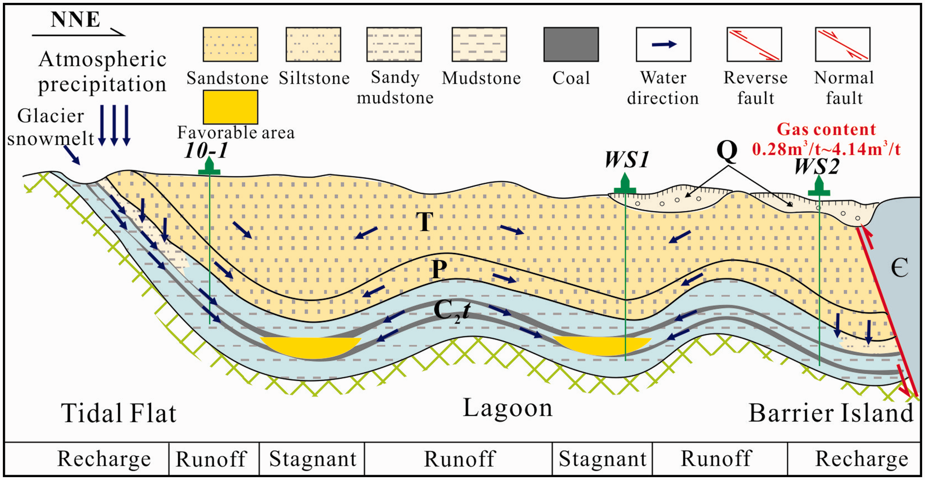
The model of CBM enrichment in the synclinorium in the Yingpan Sag of the Wuwei Basin.
Considering the gas content, structural characteristics, hydrodynamic conditions, coal thickness, coal burial depth, roof lithology, sedimentary environment characteristics and development scale of the three CBM enrichment models, the Taiyuan Formation coal in the synclinorium enrichment model was the most favorable for the formation of a large-scale CBM reservoir, and should be selected as primary targets for CBM exploration in the study area. Due to the thickness and burial depth of the coal seam, the broad syncline model and single fault with onlap model should had a secondary CBM exploration potential in the study area.
Conclusions
The macrolithotype of medium- to high-rank coals was dominated by the semi-bright coal. Coal macerals were dominated by abundant vitrinite which ranged from 65.07% to 91.6% (averaged 81.70%), relatively high contents of liptinite (averaged 8.82%) and low inertinite contents (averaged 3.66%). Minerals were found only in small amounts (2.50–15.07%, averaged 6.18%). The macrolithotype and microlithotype of the Taiyuan Formation coals were favorable for CBM formation. The sedimentary environment of the coal-bearing strata controlled the quality, thickness, and the roof lithology of the coal seam. These characteristics have a clear correlation with the gas content. The gas content of the coal formed in the lagoon was higher than that of the coal formed in the tidal flat. In addition, the sealing ability of the roof lithology which was formed in the lagoon was greater than that of the roof lithology formed in the tidal flat. Structural type and evolution play important roles in the formation, preservation, and enrichment of CBM. The key geological period for determining the CBM formation in the Wuwei Basin was the Triassic. After the Triassic, the Yanshanian and Himalayan affected the formation and preservation of CBM. Moreover, most of the faults belonged to the reverse faults and were advantageous to CBM enrichment. The TDS values of coalbed water were very high in the Yingpan Sag, and varied from 1.75 to 16.70 g/L, which illustrated the occluded hydrodynamic environment. Hydrodynamic conditions were more favorable for the CBM preservation in the Yingpan Sag of the Wuwei Basin. Considering various factors comprehensively, the three CBM enrichment models were proposed in this study, i.e., the model of CBM enrichment in the broad syncline, the model of CBM enrichment in a gently sloping syncline, and the model of CBM enrichment in the synclinorium. The Taiyuan Formation coal in the core of the synclinorium should be selected as the main target for CBM exploration in the study area.
Footnotes
Acknowledgements
The authors are grateful to the Langfang Branch, Petroleum Exploration and Development Research Institute for assistance during sampling.
Declaration of conflicting interests
The author(s) declared no potential conflicts of interest with respect to the research, authorship, and/or publication of this article.
Funding
The author(s) disclosed receipt of the following financial support for the research, authorship, and/or publication of this article: the National Science and Technology Major Project (2016ZX05041004-003) and the China Geological Survey Scientific Research Project (DD20160204-3).