
Abstract
In this study, we calculated the present-day terrestrial heat flow of the Uliastai Depression in Erlian Basin by using systematical steady-state temperature data obtained from four deep boreholes and 89 thermal conductivity measurements from 22 boreholes. Then, we calculated the lithospheric thermal structure, thermal lithospheric thickness, and lithospheric thermo-rheological structure by combining crustal structure, thermal conductivity, heat production, and rheological parameter data. Research from the Depression shows that the present-day terrestrial heat flow (qs) is 86.3 ± 2.3 mW/m2, higher than the average of 60.4 ± 12.3 mW/m2 of the continental area of China. Mantle heat flow (qm) in the Depression ranges from 33.7 to 39.3 mW/m2, qm/qs ranges from 40 to 44%, show that the crust plays the dominant position in the terrestrial heat flow. The thermal thickness of the lithosphere is about 74–88 km and characterized by a “strong crust–weak mantle” rheological characteristic. The total lithospheric strength is 1.5 × 10¹² N/m under wet mantle conditions. Present-day geothermal regime indicates that the Uliastai Depression has a high thermal background, the activity of the deep-seated lithosphere is relatively intense. This result differs significantly from the earlier understanding that the area belongs to a cold basin. However, a hot basin should be better consistent with the evidences from lithochemistry and geophysical observations. The results also show the melts/fluids in the study area may be related to the subduction of the Paleo-Asian Ocean. The study of the geothermal regime in the Uliastai Depression provides new geothermal evidence for the volcanic activity in the eastern part of the Central Asian Orogenic Belt and has significant implications for the geodynamic characteristics.
Keywords
Introduction
The Erlian Basin is located in the Xing’an-Mongolia (or Xing-Meng) Orogenic Belt between the North China Plate and the Siberian Plate (Figure 1). It has undergone multi-stage tectonic movements related to the closure of the Paleo-Asian Ocean (Chen et al., 2009; Zhang et al., 2014), closure of the Mongolia-Okhotsk Ocean (Tang et al., 2016; Wilde and Zhou, 2015), and subduction of the Paleo-Pacific plate (Maruyama et al., 2009; Wilde, 2015; Xu et al., 2013; Zhao, 2009). There were frequent magmatic intrusions and volcanic eruptions in the region. Granites developed extensively by post-orogenic lithospheric extension in early Early Cretaceous (Wu et al., 2007, 2011; Yuan et al., 2017). The Abaga volcanic field and Dalinuoer volcanic field developed in Quaternary (Fan et al., 2015). Geophysical surveys show that the total crustal thickness of the Hegenshan fold belt ranges from 39 to 40 km (Guo et al., 2015; Lu et al., 1993) and the lithospheric thickness is about 100 km (An and Shi, 2006; Xiong et al., 2015). There are geochemical evidences that the mantle peridotite xenoliths of Abaga and Jining were derived from the depths of 40–70 km (Chen et al., 2012; Du et al., 2006; Zhang et al., 2006). The above geology, geochemistry, and geophysical observations indicate that tectonic activity is intense in this region, volcanic and magmatic activities are frequent, and the thickness of lithosphere is relatively thin. The evolution of deep lithosphere is always accompanied by a change of the lithospheric thermal regime. Thus, one would expect the Erlian Basin to be a hot basin. However, the average of the only four heat flow estimates is about 55.6 mW/m2 (Jiang et al., 2016). Thus, the Erlian Basin has been considered a typical cool basin. Apparently, the early estimates of heat flow from the Erlian Basin are inconsistent with evidences from geology, geochemistry, and geophysical observations. Recently, we have obtained systematical steady-state temperature data from four deep boreholes and 89 thermal conductivity measurements from 22 boreholes from the Uliastai Depression. We reevaluated the present-day terrestrial heat flow of the Uliastai Depression in Erlian Basin based on the borehole temperature and thermal conductivity data. Then, the lithospheric thermal structure, thermal lithospheric thickness, and lithospheric thermo-rheological structure were studied.
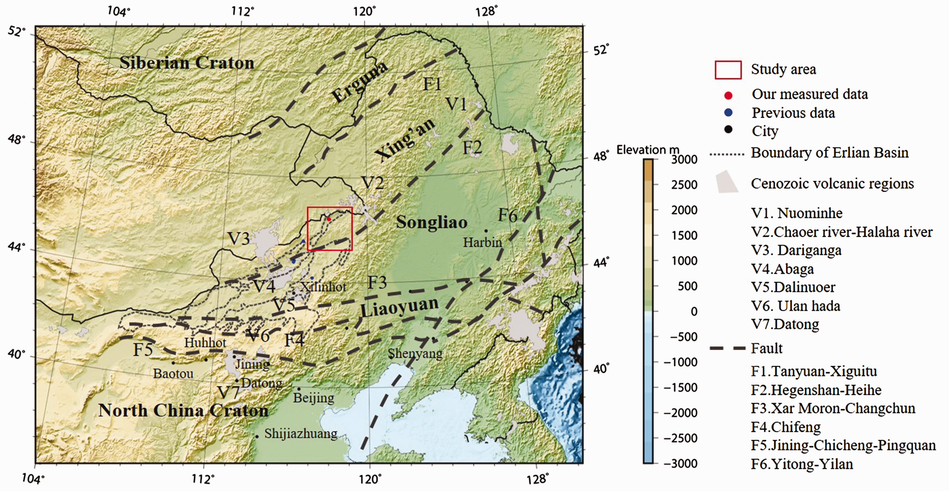
Tectonic subdivisions of northeastern China. (Tectonic data are from Wu et al., 2011; Zhao et al., 2017; volcanic distribution is from Yarmolyuk et al., 2015; the topographic contour employs ETOPO 1 data from the National Geophysical Data Center).
Geological setting
The Erlian Basin is located at the junction of the North China Plate and the Siberia Plate. It is a sedimentary fault basin which developed on the Hercynian fold basement in Mesozoic-Cenozoic (Pan et al., 2009; Qi et al., 2015; Shao et al., 1997). It has experienced continental accretion, intercontinental collision, and orogeny (Khain et al., 2002). The Solonker suture has thought to be the final suture in the eastern section of the Central Asian Orogenic Belt (CAOB) (Xiao et al., 2003a; Zhang et al., 2014; Zhao et al., 2017). On the northern side of the suture forming the Baolidao arc-accretion complex belt and the Hegenshan ophiolitic melange belt by northward subduction of the Paleo-Asian Ocean and collision with the Siberia Plate. In contrast, on the southern side of it formed the Wendurian subduction-accretionary complex belt and the Bainaimiao arc belt by the subduction of the Paleo-Asian Ocean and collision with the North China Plate.
The Uliastai Depression is located in the northeast corner of the Erlian Basin (Figure 1). The tectonic evolution of the Uliastai Depression has been divided into four stages: post-collision orogeny (Late Permian—Middle Triassic), intracontinental extension (Middle-Late Jurassic), lithospheric thinning (Early Cretaceous) and slightly compressional differentiated uplifting-subsidence (since Late Cretaceous) (Wei et al., 2006; Zhang et al., 2010). It was mainly affected by the Yanshanian movement and formed an Early Cretaceous rift lake basin. The sedimentary fill consists of the Early Cretaceous Aershan, Tenggeer, Saihantala Formations, the Late Cretaceous Erliandabusu Formation and the overlying Cenozoic succession.
Terrestrial heat flow
Terrestrial heat flow is equal to the product of the thermal conductivity and the vertical geothermal gradient. Systematical steady-state temperature data are measured in the drilled well, and the rock samples for thermal properties in the corresponding depth intervals are collected. Then, the geothermal gradient and the thermal conductivity can be determined, respectively. With these two parameters, we can get the heat flow values. Its mathematical expression is

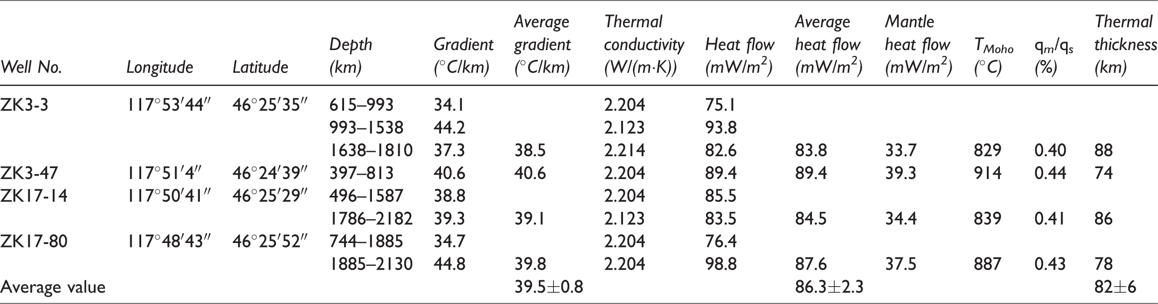
In this study, we calculated the terrestrial heat flow of the Uliastai Depression based on the systematical steady-state temperature data from four deep boreholes and 89 thermal conductivity measurements from 22 boreholes (Table 1, the detailed data see in Xu et al. (in preparation)). The geothermal gradient of four boreholes ranges from 38.5 to 40.6°C/km, with an average of 39.5 ± 0.8°C/km. The thermal conductivity is 1.235–3.242 W/m·K−1, with an average of 2.134 ± 0.363 W/m·K−1. After correction for water-saturation, the thermal conductivity ranges from 1.318 to 3.328 W/m·K−1, with an average of 2.214 ± 0.363 W/m·K−1. Based on the above data, we obtained the heat flow value in the Uliastai Depression. It ranges from 83.8 to 89.4 mW/m2, with an average of 86.3 ± 2.3 mW/m2. Our result is higher than 55.6 mW/m2 of the average of the only four heat flow estimates of the Erlian Basin (Jiang et al., 2016). It is also higher than 60.4 ± 12.3 mW/m2 of the average of terrestrial China (Jiang et al., 2016).
Thermal regime data of the Uliastai Depression.
Lithospheric thermal structure
Thermal structure of the lithosphere is the ratio of crustal and mantle heat flow to surface heat flow (Blackwell, 1971). Among them, crustal heat flow is from the radiogenic heat produced by the decay of radioactive elements (e.g. U, Th, K), mainly concentrated in the uppermost part of the crust. Mantle heat flow is the heat transfer from Earth's interior to the Moho.
In the sedimentary basin, mantle heat flow can be obtained by the “stripped-back” method based on the heat flow, radioactive heat production rate, and thickness of crustal layering. The formula is


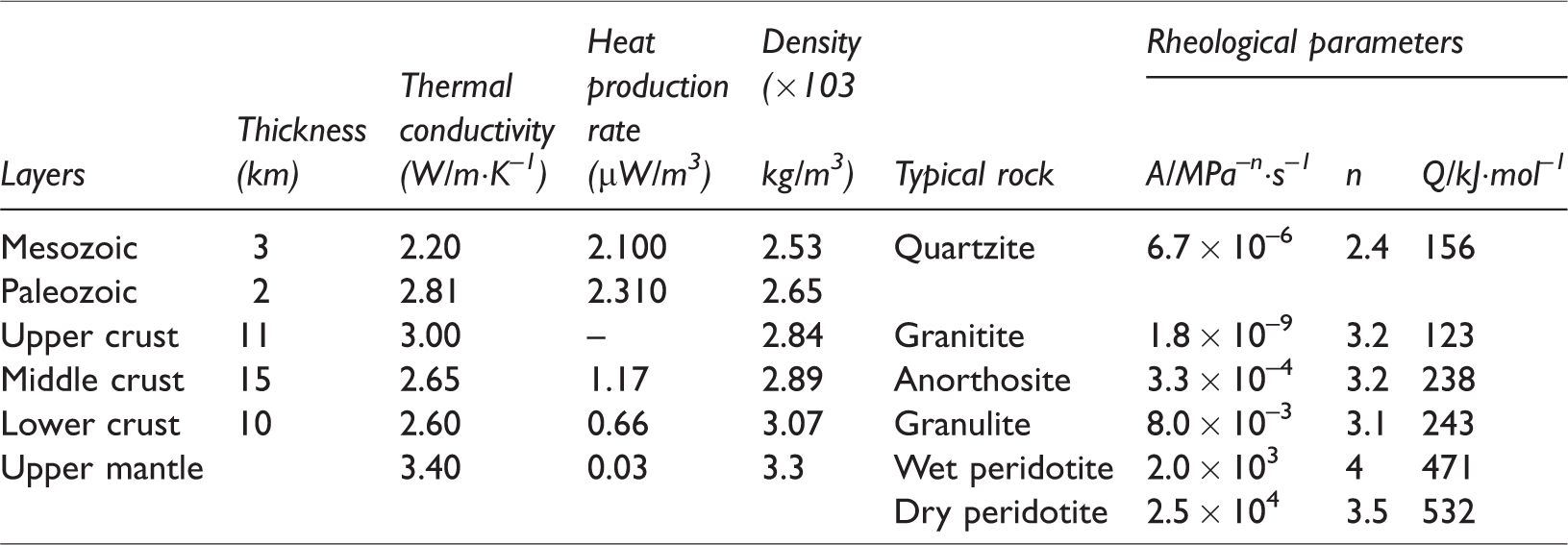
In this paper, we collected heat production data of the sedimentary strata from Zhongyuan Oilfield. The heat production data of the crust and mantle refer to Rudnick et al., (1998). The heat production data of the middle and lower crust refer to Li (1996). Thickness of crustal layering data refer to Lu et al. (1993). All the parameters can be seen in Table 2.
Parameters of the lithospheric thermal–rheological structure for the Uliastai Depression.
Then, we calculated thermal structure of the lithosphere based on the heat flow values, the heat production rate, and the thickness of crustal layering (Table 1). The results show that mantle heat flow in the Uliastai Depression ranges from 33.7 to 39.3 mW/m2, the crustal heat flow is 50.0 mW/m2, the temperature of Moho is about 829–914°C, and the qm/qs ratio ranges from 40 to 44%. The qm/qs ratio indicates the terrestrial heat flow is mainly controlled by the crust. The crust heat flow of the Uliastai Depression is higher than most of the cratons in global (Xu and Qiu, 2017). It is similar to the Gawler Craton of Australia (Neumann et al., 2000; McLaren et al., 2003) and the Aravalli and Singbhum Cratons of India (Roy and Jean-Claude, 2011; Roy and Rao, 2000). The reason for anomalously high crustal heat flow is caused by high concentrations of heat-producing elements in the crust. However, the mantle heat flow of the Uliastai Depression is also significantly higher than most of the cratons in global, most of them range from 10 to 20 mW/m2 (Gupta, 1993; Jaupart and Mareschal, 1999; Roy and Jean-Claude, 2011). This high mantle heat flow may result from the deep-seated processes in the upper mantle and reflects the tectonic instability of the crust. The previous study of Europe suggests that the Moho-temperature can exceed 900°C in intrarnontane depressions or rift structures and mantle heat flow can be as large as 40 mW/m2 (C˘Ermák, 1982). The Uliastai Depression is just in the rift structure of the Paleo-Asian Ocean. The higher heat flow of the mantle indicates that the activity of the deep-seated lithosphere is relatively stronger.
Thermal lithospheric thickness
Thermal lithospheric thickness is calculated by the equation of one-dimensional heat conduction and the mantle adiabat Tm=1300°C (Artemieva and Mooney, 2001; Morgan, 1984; Rudnick et al., 1998). The equation of one-dimensional heat conduction equation is

Based on the thermal conductivity (Furlong and Chapman, 2013; He, 2014; Rudnick et al., 1998), the heat production rate (Li, 1996; Rudnick et al., 1998), and the thickness of crustal layering (Lu et al., 1993), we calculated the thermal lithospheric thickness of the Uliastai Depression (Table 1 and Figure 2). Thermal lithospheric thickness in the Uliastai Depression ranges from 74 to 88 km and has an average of 82 ± 6 km. The thickest thermal lithosphere reaches up to 88 km in ZK3–3. The thinnest is 74 km in ZK3–47. Our results of thermal lithospheric thickness are thicker than lithosphere thickness data determined by thermobarometry studies of xenoliths. Based on the Cenozoic mantle peridotite xenoliths from Abaga area in Inner Mongolia, the lithospheric thickness was estimated as 40 to 55 km (Chen et al., 2012), which may be the results of the presence a significant amount of volatiles in the lithospheric mantle. However, both of them demonstrate that the Uliastai Depression has a thinner lithosphere.
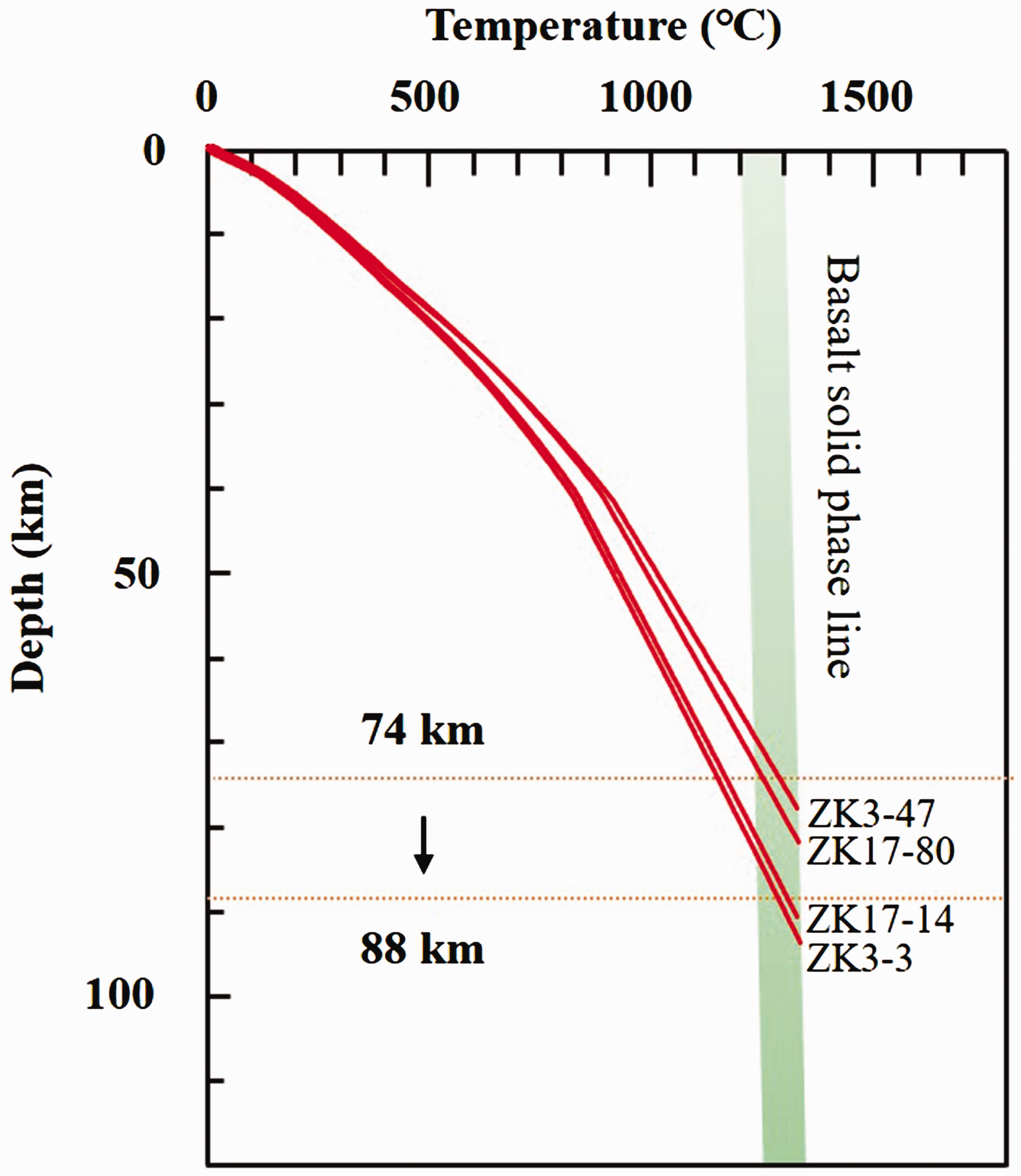
Temperature-depth curves of the lithosphere in the Uliastai Depression.
Thermal lithospheric thickness provides new geothermal evidence for the relatively intense activity of the deep-seated lithosphere in the Uliastai Depression. The thermal lithospheric thickness of the Uliastai Depression is thinner than that of the most cratons in global (150–300 km) (Xu and Qiu, 2017). However, it is similar to the Bohai Bay Basin (60–80 km) (He et al., 2001), which belongs to a hot basin. Bohai Bay Basin is the center of lithospheric destruction and thinning of the eastern North China Craton with decreased by over 100 km during the Meso-Cenozoic (Huang et al., 2009; Menzies et al., 1993; Qiu et al., 2014; Zhu et al., 2012). Previous research results proved that the Early Cretaceous was a period of intensive magmatism, mineralization, and lithospheric thinning in ENCC (Wu et al., 2005; Xu et al., 2004). Studies on the basin and metamorphic core complexes in North China indicated that the Early Cretaceous was the peak period of lithospheric extension, rifting basin, and craton destruction (Lin and Wang, 2006; Liu et al., 2005; Ren et al., 2002). Lithospheric destruction and thinning of the eastern North China Craton have resulted in mantle transformation, crust reconstruction, magmatic activities, Mesozoic basin formation, and uplifted plateau to terrain (Griffin et al., 1998; Huang et al., 2009; Li et al., 2012; Tian et al., 2009; Yang et al., 2003; Zhu et al., 2011). Thus, Bohai Bay Basin is a hot basin and is characterized by the relatively intense activity in the deep-seated lithosphere. Similarly, the Uliastai Depression has developed frequent magmatic intrusions and volcanic eruptions since Mesozoic (Fan et al., 2015; Wu et al., 2011; Yuan et al., 2017). It has experienced four stages of tectonic activity: post-collision orogeny (Late Permian—Middle Triassic), intracontinental extension (Middle-Late Jurassic), lithospheric thinning (Early Cretaceous) and slightly compressional differentiated uplifting-subsidence (since Late Cretaceous) (Wei et al., 2006; Zhang et al., 2010). However, we can conclude that the Uliastai Depression is also a hot basin and is characterized by the relatively intense activity in the deep-seated lithosphere.
Thermal–rheological structure
Lithospheric rheology is defined as the flow and deformation of the lithosphere under tectonic force. Lithospheric rheology is closely related to the thermal regime of the lithosphere known as “lithospheric thermal–rheological structure.” The lithospheric yield strength envelops (or rheological profile) can be constructed by combining the lithospheric thermal regime calculated by the equation of one-dimensional heat conduction with the linear frictional failure criterion formula and the creep strength formula.
The upper crust is characterized by brittle deformation and governed by the linear frictional failure criterion formula (Sibson, 1974).

In the mid-lower crust, the creep strength for plastic deformation in the crust is dominated by the power–law proposed by (Kirby, 1983), namely
Yield strength in the shallow lithosphere can be determined by 
In this study, the lithosphere of the Uliastai Depression was divided into six layers: quartzite for sedimentary (Mesozoic and Paleozoic), granitite for the upper crust, anorthosite for the middle crust, granulite for the lower crust, and peridotite for the upper mantle (Lu et al., 1993) (Table 2). During the calculation, each layer was characterized by different rheological parameters (Ranalli, 1997), densities (Feng, 1985; Lu et al., 1993; Wang et al., 1990), heat productions and thermal conductivities (Furlong and Chapman, 2013; He, 2017; Rudnick et al., 1998), and layered crustal structures (Lu et al., 1993). The average value of heat flow is 86.3 mW/m2. The Uliastai Depression was in a slightly compressional differentiated uplifting-subsidence tectonic environment since Late Cretaceous (Wei et al., 2006). We assumed that the steady-static strain rate is 10−15 s−1. The water content in the upper mantle should also be considered. The resistance of mantle olivine is strongly reduced due to the presence of fluids in continents (Burov, 2011; Jackson, 2002), and more recent studies have detected high water content only in the upper mantle below the lithosphere but not in the lithosphere itself (Katayama et al., 2005).
Based on different mantle water contents (wet or dry) and compressional stress environments, we calculated the lithospheric thermal–rheological structure profiles and total lithospheric strength of the Uliastai Depression (Figure 3). Only the upper crust is of a brittle layer and the others are of ductile layers. The portion of crust plays a vital role in the total lithospheric strength, and the lithosphere is characterized by a “strong crust–weak mantle” structure. BDTD is 5.5 km in the upper crust. The total lithospheric strengths are 1.7 × 10¹² and 1.5 × 10¹² N/m under wet and dry mantle conditions, respectively. The results indicate that water content decreases the lithospheric strength. The rheological characteristic in the Uliastai Depression is identical to the rheological characteristic in the Jiyang sub-basin of the Bohai Bay Basin during the early Early Cretaceous (Xu et al., 2018). Both of them show that the crust plays a vital role in the total lithospheric strength, and the rheological characteristic exhibits “strong crust–weak mantle” structure. The results also reflect the lithosphere of the Uliastai Depression can be easily deformed and exhibits a tectonic activity region.
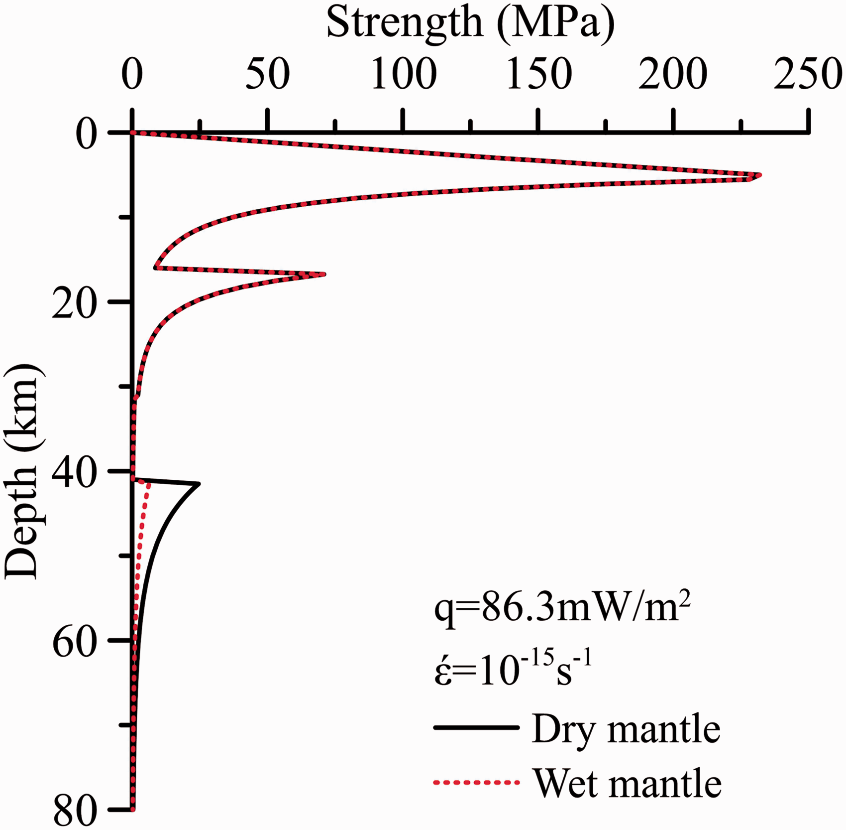
Lithospheric thermal–rheological structure of the Uliastai Depression.
Discussion
Thermal background
The Erlian Basin has been considered a typical cool basin. However, our results presented above indicate that the Uliastai Depression has a high thermal background, and the activity of the deep-seated lithosphere is relatively stronger. This result differs significantly from the earlier understanding of the area. The terrestrial heat flow of the Uliastai Depression is 86.3 ± 2.3 mW/m2 reevaluated based on the four boreholes temperature and 89 thermal conductivity data. The value is consistent with that of the Baiyinchagan Depression (74.4 ± 10.3 mW/m2) (Zhang et al., 2017) and that of the Chagan Depression (74.5 mW/m2) (Zuo et al., 2013). All the heat flow of the three depressions indicate that the Erlian Basin belongs to a hot basin. This result is consistent with evidences from geology, geochemistry, and geophysical observations (An and Shi, 2006; Chen et al., 2012; Du et al., 2006; Fan et al., 2015; Guo et al., 2015; Lu et al., 1993; Xiong et al., 2015; Yuan et al., 2017; Zhang et al., 2006). And, it is also can be proved by our results of thermal structure, thermal lithospheric thickness, and thermal–rheological structure in the Uliastai Depression.
The high thermal background may be the effects of the closure of the Paleo-Asian Ocean and the Paleo-Pacific subduction. The closure of the Paleo-Asian Ocean is considered to have occurred much earlier, perhaps starting in the Carboniferous and ending in the Late Permian (Safonova and Santosh, 2014; Xiao et al., 2003b; Zhang et al., 2010). Then, granites developed extensively by post-orogenic lithospheric extension in Permian and Triassic (Wu et al., 2011). The Jurassic granites have been explained as the result of Paleo-Pacific subduction (Wu et al., 2007, 2011). The Cretaceous granites are typical of magmas generated in a lithospheric thinning environment caused by the Pacific subduction (Wilde and Zhou, 2015). The magmatic intrusions developed frequently since the closure of the Paleo-Asian Ocean and the Paleo-Pacific subduction. There is a certain correlation in high thermal background and intense tectonic activity in the deep-seated lithosphere. During the Cenozoic, the volcanisms causing by the Pacific subduction developed extensively in the Northeast China (Fan et al., 2015). The high thermal background may also be related to the shallow volcanic eruptions.
Evidence of melts/fluids source
The calculation results of the one-dimensional heat transfer model in this paper show that the intersection of the geothermal curve and the solidus ranges from 74 to 88 km and the temperature is about 1300°C in the Uliastai Depression (Figure 4). This illustrates the maximum melting depth and temperature of the lithosphere in the dry mantle condition. However, duo to the presence of the volatile matter in the mantle, the melting condition of depth and temperature of the lithosphere can be decreased. Figure 4 shows melting curves from Furlong and Chapman (2013). If we assume that the partially hydrous 50 ppm and wet mantle melt lines represent much of the upper mantle, then we should expect partial melting at the base of the lithosphere for continental regions in the depth range of 40–80 km and the temperature range of 900–1300°C. It is consistent with the geochemical evidence of the Cenozoic mantle peridotite xenoliths from the Abaga and Jining volcanic area. The evidences from thermobarometry studies of the Cenozoic mantle peridotite xenoliths have proved that the lithospheric root of the Abaga and Jining volcanic area is about 40–60 km (Chen et al., 2012; Du et al., 2006; Wang et al., 2017; Zhang et al., 2006). Thus, these geotherms provide an explanation for the presence a significant amount of volatiles in the lithospheric mantle in Abaga and Jining volcanic area, prompting the lithospheric mantle to melt.
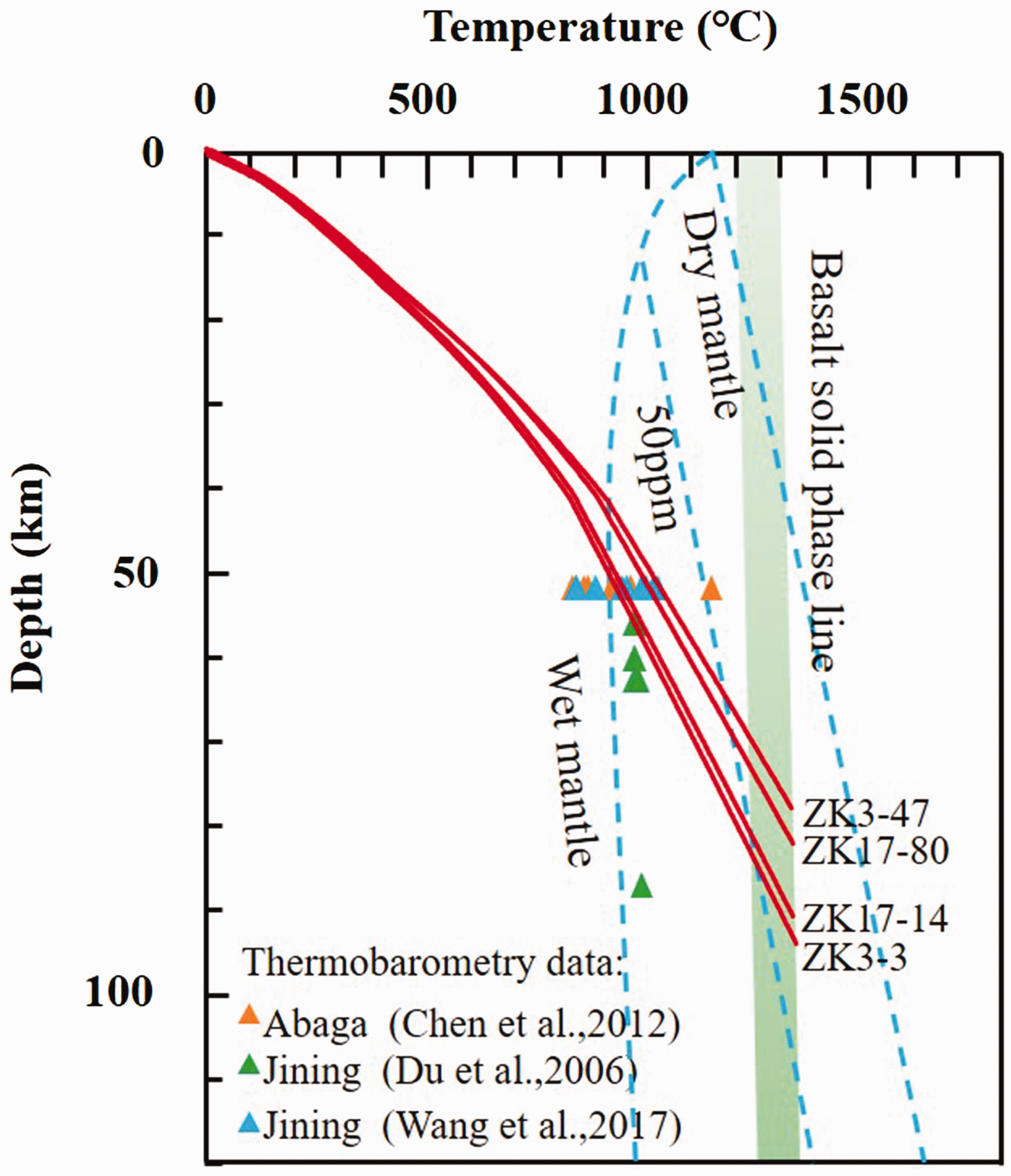
Temperature-depth curves and xenolith thermobarometry data in the study area (solidus data cited from Furlong and Chapman, 2013).
The Abaga volcanic area has documented two types of the mantle, a younger transitional-fertile mantle and an older refractory mantle at high levels of depletion (Chen et al., 2012; Zhang et al., 2012). Such phenomena may be related to the heterogeneous intermingling and replacement of materials from the younger mantle to the older mantle, and the recirculation of oceanic crust materials (Wang et al., 2017; Zhang et al., 2012). The southward movement of the Paleo-Asian Ocean plate should be an important cause, and led to subduction under the North China plate. During the subduction process, as the degree of metamorphism increased and some water-bearing minerals were successively decomposed, fluid would be released to form a fluid flow (Chen et al., 2009; Zhang et al., 2014). The melts/fluids released during the subduction of the Paleo-Asian Ocean plate provides the possibility of modification, replacement, and melting of lithospheric mantle in the area.
Conclusions
Based on the study of the present-day thermal regime in the Uliastai Depression, the main conclusions of this paper are as follows:
The present-day thermal regime of the Uliastai Depression in Erlian Basin shows that the region and the surrounding area are characterized by the high thermal background, and the activity of the deep-seated lithosphere is relatively stronger. The average heat flow is 86.3±2.3 mW/m2. Mantle heat flow ranges from 33.7 to 39.3 mW/m2, and the crustal heat flow is 50.0 mW/m2. qm/qs ratio ranges from 40 to 44%. Thermal lithospheric thickness is 74–88 km. The total lithospheric strength is 1.5 × 10¹² N/m under wet mantle condition and is characterized by a “strong crust–weak mantle” structure. The lithosphere of the Uliastai Depression can be melted and be strongly modified in the depth range of 40–80 km and the temperature range of 900–1300°C. It provides new evidence that the melts/fluids may be from the subduction of the Paleo-Asian Ocean plate.
Footnotes
Acknowledgements
We would like to thank Prof. Hu Shengbiao (Chinese Academy of Sciences, China) for providing test team and equipment for the systematical steady-state temperature measurement in the Uliastai Depression. We also thank the Zhongyuan Oilfield and individuals who contributed cores and information to this work.
Declaration of conflicting interests
The author(s) declared no potential conflicts of interest with respect to the research, authorship, and/or publication of this article.
Funding
The author(s) disclosed receipt of the following financial support for the research, authorship and/or publication of this article: The National Natural Science Foundation of China (Grant 41374089) provided financial support.