
Abstract
Studies have found that the Permian is another important stratum for petroleum exploration except the Jurassic coal measures within Turpan–Hami Basin recently. However, the knowledge of the depositional environments and its petroleum geological significances during the Middle–Late Permian is still limited. Based on the analysis about the sedimentological features of the outcrop and the geochemical characteristics of mudstones from the Middle Permian Taerlang Formation and Upper Permian Quanzijie Formation in the Taoshuyuanzi profile, northwest Turpan–Hami Basin, this paper makes a detailed discussion on the Middle–Late Permian paleoenvironment and its petroleum geological significances. The Middle–Upper Permian delta–lacustrine depositional system was characterized by complex vertical lithofacies assemblages, which were primarily influenced by tectonism and frequent lake-level variations in this area. The Taerlang Formation showed a significant lake transgression trend, whereas the regressive trend of the Quanzijie Formation was relatively weaker. The provenance of Taerlang and Quanzijie Formations was derived from the rift shoulder (Bogda Mountain area now) to the north and might be composed of a mixture of andesite and felsic volcanic source rocks. The Lower Taerlang Formation was deposited in a relatively hot–dry climate, whereas the Upper Taerlang and Quanzijie Formations were deposited in a relatively humid climate. During the Middle–Late Permian, this area belonged to an overall semi-saline water depositional environment. The paleosalinity values showed stepwise decreases from the Lower Taerlang Formation to the Upper Quanzijie Formation, which was influenced by the changes of paleoclimate in this region. During the Middle–Late Permian, the study area was in an overall anoxic depositional environment. The paleoenvironment with humid climate, lower paleosalinity, anoxic condition, and semi-deep to deep water during the deposition of the Upper Taerlang Formation was suitable for the accumulation of mudstones with higher TOC values.
Keywords
Introduction
Turpan–Hami Basin is one of the most important petroliferous basins in Xinjiang province, western China. Although the Jurassic coal measures, widespread in Middle Asia, have long been proved as the key stratums of oil and gas exploration and production in this basin (Hu et al., 1996; Tong, 1999; Zhang et al., 2002), many studies have also found that the Permian is another important stratum for oil and gas exploration recently (Wang and Yang, 2004; Zhai et al., 2016; Zhang, 2014).
Previous researches on the Permian geological characteristics were mainly focused on the tectonic evolution, paleogeographical pattern, and organic geochemical characteristics of mudstones within this basin (Deng et al., 2009; Li et al., 1997; Miao, 2001; Shi, 2006; Shi et al., 1995; Wartes et al., 2002; Wei et al., 2016; Zhang, 1988; Zhou, 2008). Scholars noted that the Permian spanned a critical tectonic and paleogeographical transition period for this basin. During the Carboniferous to Early Permian, the Junggar, Turpan–Hami, and Yingen Basin areas in Mid-Western China existed as a shallow seaway that belonged to a portion of the Paleo–Asian Ocean (i.e. Tianshan–Hingan seaway in China) that separated the Siberian plate in the north with Tarim and North China block in the south (Shi, 2006; Wei et al., 2016; Zhang, 1988). Extensive and intensive tectonic movements occurred in Eastern Xinjiang (i.e. the Eastern Junggar Basin and the Turpan–Hami Basin areas) and had been active until the late Early to early Middle Permian, associated with the final closure of the Paleo–Asian Ocean in this region (Deng et al., 2009; Shi et al., 1995; Wartes et al., 2002; Wei et al., 2016). The sedimentary setting of the Turpan–Hami Basin had remarkably changed and gradually evolved from marine into continental, which was dominated by fluvial–lacustrine facies (Liu et al., 2006; Mu, 1993; Stratigraphical Lexicon of China compiling commission, 2000; Xu et al., 2013). In addition, the organic geochemical characteristics of Permian mudstones have also aroused the great interest of scholars (Miao, 2001; Zhou, 2008). Miao (2001) proposed that mudstones from the Middle Permian Taerlang Formation, widespread in this basin and characterized by type II1 and III organic matter, high total organic carbon (TOC), and high thermal evolution degree, were the important source rocks. Proved hydrocarbon reserves of the Turpan–Hami Basin are 4.62 × 10⁸t, about one-fifth of which might have been derived from Permian source rocks (Zhang, 2014).
However, the knowledge of the depositional environments (especially to provenance, paleoclimate, paleosalinity and so on) during the Permian (especially during the Middle–Late Permian, i.e. the closure and post-closure period of the Paleo–Asian Ocean) is still limited and lack systematicness. For example, studies on the provenance were mainly based on petrological characteristics (Shao et al., 1999; Xu et al., 2013) but there is lack of the evidences from elemental geochemistry (such as rare earth and trace metal elements). Miao (2001) noted that the Eastern Xinjiang area belonged to an overall warm climate during the Permian, but the shorter-term vertical changes of paleoclimate have not been studied. The paleosalinity was gradually reduced from the Middle Permian to the Later Permian (Miao, 2001), but its controlling factors have not been discussed. Furthermore, the petroleum geological significances of the depositional environment (e.g. whether the paleoenvironment was beneficial for the production and preservation of organic matter or not) also have received significantly little attention. These might restrict the further understanding for the Permian sedimentology and petroleum geological condition within this basin.
The interpretation of sedimentary environments (e.g. water depth, provenance, paleoclimate, paleosalinity, and redox condition) is critical to determine the depositional background, filling succession, sedimentary facies, depositional evolution, and petroleum geological condition of the basins (Hassan et al., 2017; Legler et al., 2011; Ye et al., 2016). Petrographical, paleontological, and lithological observations have been extensively used as proxies to infer the depositional environments (Hassan et al., 2017; Kupecz et al., 1997; Legler et al., 2011; Moore and Druckman, 1981; Schmoker and Halley, 1982; Wei et al., 2016). Moreover, the geochemical compositions of sedimentary rocks, particularly the trace element compositions, are supplementary to fingerprint the depositional environments (Hassan et al., 2017; Legler et al., 2011; McLennan, 1989; Pi et al., 2013; Song et al., 2012; Trueman and Tuross, 2002; Yang et al., 2014; Ye et al., 2016). The abundances and ratios of selected trace elements can reflect well the diagenesis, paleoclimate, salinity of water medium, and redox condition of sedimentary environment (Bai et al., 2015; Hatch and Leventhal, 1992; Jones and Manning, 1994; Legler et al., 2011; Leman, 1989; Liu, 1980; Liu and Zeng, 1985; Song et al., 2012; Trueman and Tuross, 2002). Partial rare earth elements are stable in the processes of weathering, transportation, deposition, and diagenesis of the parent rocks (Bai et al., 2015; Zhang and Zhang, 2006; Zhu et al., 2002). The characteristic analysis of these elements is widely applied in studying the diagenesis, properties of sedimentary sources, and ancient water medium (Armstrong-Altrin et al., 2004; Bai et al., 2015; Bhatia and Crook, 1986; Charles et al., 2008; Cao et al., 2012; Feng et al., 2010; Ma et al., 2017; McLennan, 1989; Pi et al., 2013; Shields and Stille, 2001; Tao et al., 2014; Wright et al., 1987; Zhang and Zhang, 2006; Zhu et al., 2002).
This work presents a description of the sedimentology characteristic of outcrop in the Taoshuyuanzi (TSYZ) section of the northwestern Turpan–Hami Basin. Based on the systematic analysis of trace and rare earth elements and clay mineral contents of mudstone samples, the diagenesis, sedimentary sources, paleoclimate, paleosalinity, and redox condition are also discussed. Combining the sedimentology and geochemistry research results, we reconstruct the paleoenvironment and depositional filling of the Middle–Upper Permian and discuss the petroleum geological significance of the sedimentary environment in the northwest Turpan–Hami Basin. Hence, this study will provide important basic data for the further understanding of the Permian sedimentology and petroleum geological condition in the Turpan–Hami Basin.
Geological setting
The Turpan–Hami Basin is located in northwestern China (Figure 1(a)) and lies in the suture zone of Siberian and Tarim plates (Wang, 2015; Zhang, 2014). This basin is bounded by the Bogda Mountain to the north, the Karawushen Mountain to the northwest, and the Jueluotage Mountain to the south (Zou et al., 1992) (Figure 1(b)). The research area has a complex tectonic and sedimentary history (Obrist-Farner and Yang, 2017). During the Late Neoproterozoic to the Early Paleozoic, the Turpan–Hami Basin and adjacent regions were part of the Paleo–Asian Ocean, which separated the Siberian plate to the north with the North China and Tarim plates to the south (Zhang, 1991). This basin evolved to be a continental amalgamation stage during the Devonian–Carboniferous (Allen et al., 1993; Carroll et al., 1995). The pre-Permian basement in Turpan–Hami Basin appears to be similar to that of the Junggar Basin and is composed of Proterozoic metasedimentary units and Devonian–Carboniferous clastic, carbonate, volcaniclastic, and intermediate-acidic volcanic rocks (Greene et al., 2005; Mao et al., 2014; Min et al., 2005; Shao et al., 2001).
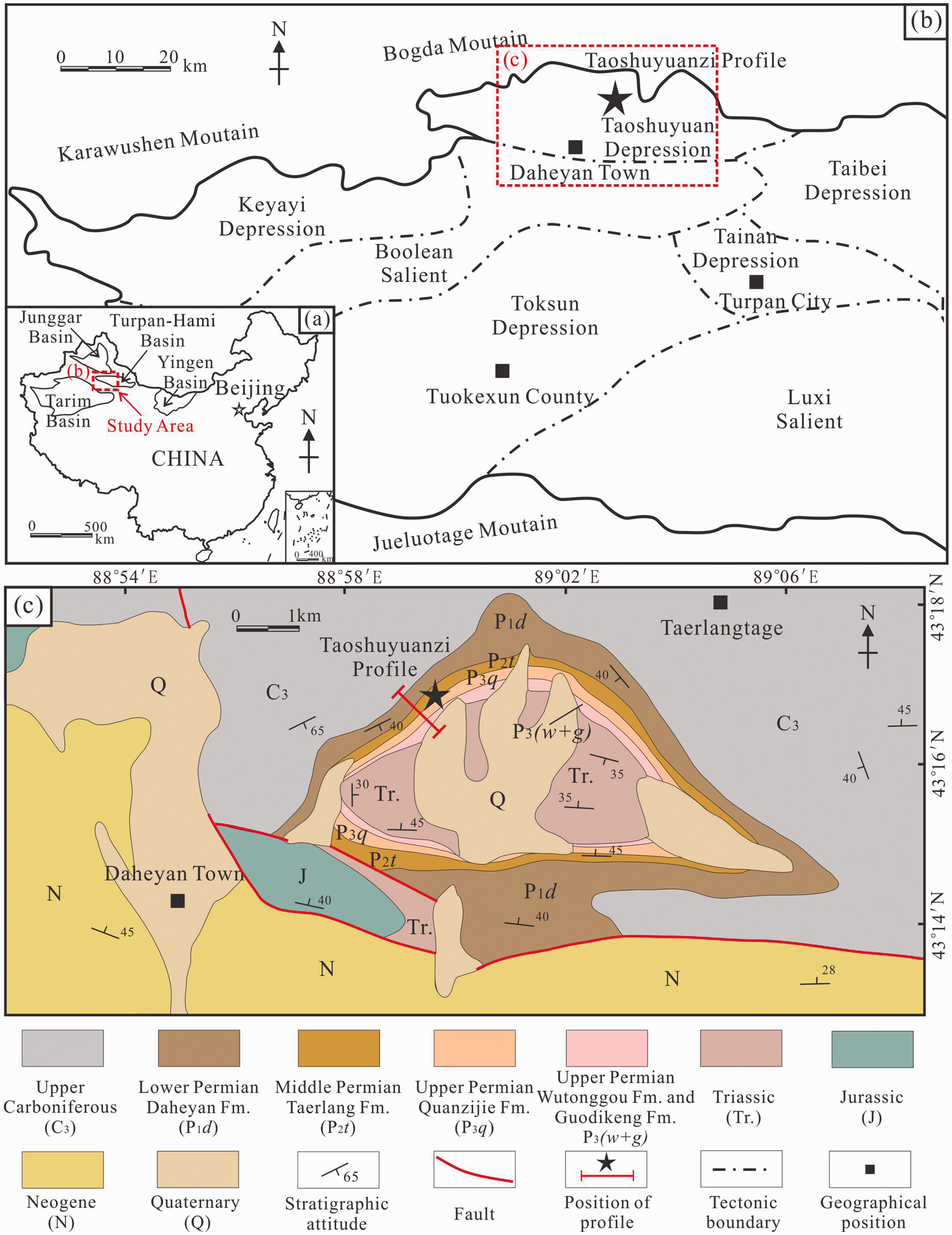
(a) Geographical location of the study area in China. (b) Geotectonic division of the northwest Turpan–Hami Basin (modified from Yang, 2013). (c) Regional geology map of the Daheyan Town area (modified from Xinjiang Geological Survey, 1960, 1975) and location of the Taoshuyuanzi (TSYZ) profile.
The Permian represents a critical tectonic and paleogeographical transition period characterized by intense tectonic activities due to the collision and amalgamation of the Siberian block with the North China and Tarim blocks and the gradual closure of the Paleo–Asian Ocean in Eastern Xinjiang area during the late Early to early Middle Permian (Deng et al., 2009; Jiang et al., 2015; Mao et al., 2006; Shi et al., 1995; Wartes et al., 2002; Wei et al., 2016; Zhang et al., 2013). The reworking of crustal discontinuities during the convergence between Junggar and central Tianshan might have caused the crustal extension (Laurent-Charvet et al., 2003), forming several Permian small half-grabens and grabens (Yang et al., 2010), and this basin was considered as an intracontinental rift basin during the Permian (Laurent-Charvet et al., 2003; Yang et al., 2010). Yang (2013) proposed that several depressions and salients (i.e. the Taoshuyuan Depression in the north (Figure 1(c)), the Keyayi Depression, Boolean Salient, Taibei Depression, and Tainan Depression in the middle, and the Toksun Depression and Luxi Salient in the south) were developed in the northwestern Turpan–Hami Basin (Figure 1(b)). Permian filling successions contain Yierxitu and Daheyan Formations in Lower Permian, Taerlang Formation in Middle Permian, and Quanzijie, Wutonggou, and Guodikeng Formations in Upper Permian (Shao et al., 2001; Stratigraphical Lexicon of China compiling commission, 2000; Xu et al., 2013) (Figure 2). The Permian consists of continental clastic–pyroclastic rocks and a few limestones deposited mainly in a fluvial–delta–lacustrine environment (Shao et al., 2001; Stratigraphical Lexicon of China compiling commission, 2000; Xu et al., 2013) (Figure 2). The Young Tian Shan arc (currently known as Jueluotage Mountain area) to the south was the main provenance, whereas the rift shoulder (currently known as Bogda Mountain area) to the north was a local source for the sediments in the Turpan–Hami Basin during the Permian (Obrist-Farner and Yang, 2017).
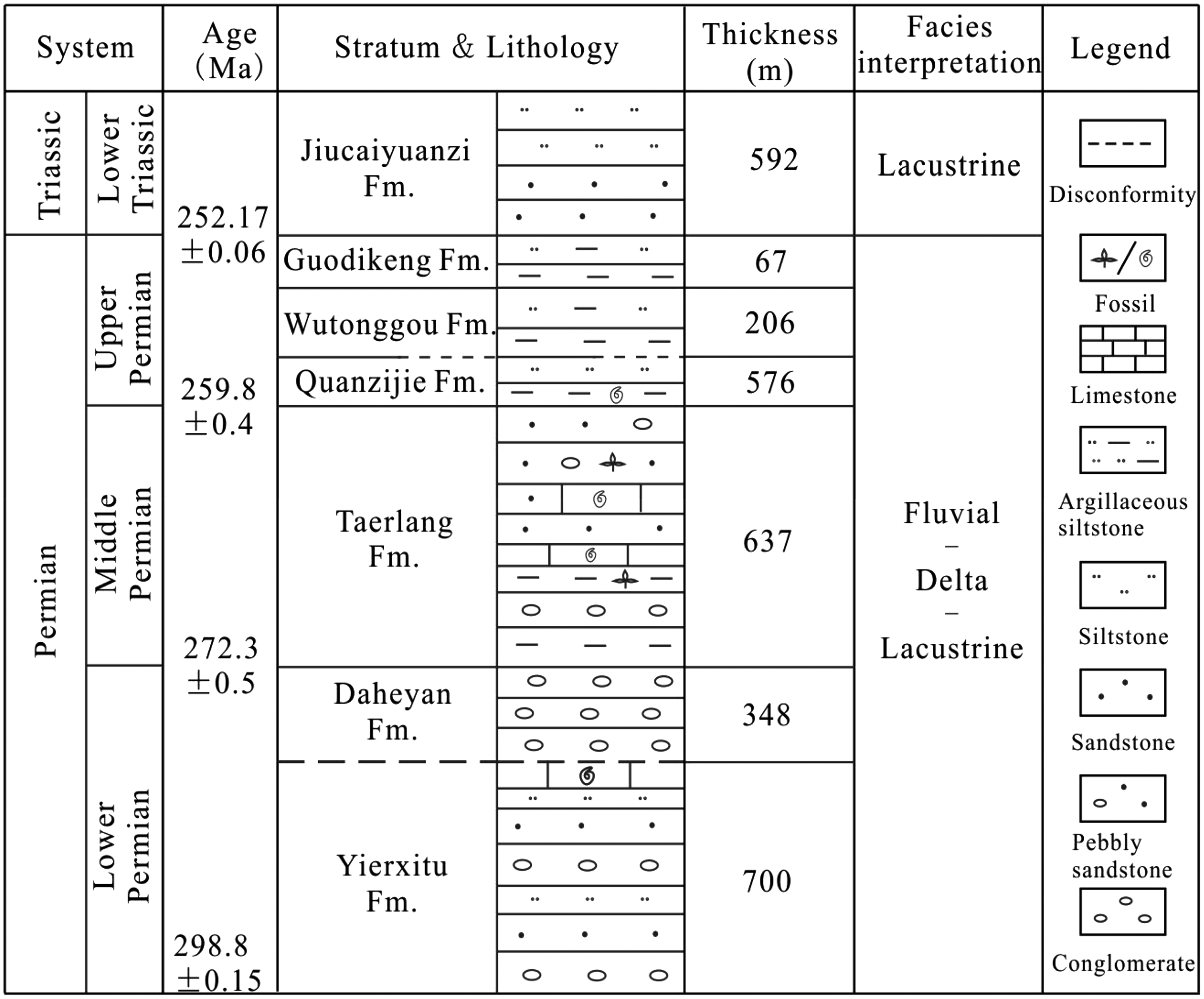
The Permian stratum of Turpan–Hami Basin (modified from Shao et al., 2001; Stratigraphical Lexicon of China compiling commission, 2000; Xu et al., 2013).
The Bogda Mountain might have started to uplift during the early to mid-Mesozoic and separated the Turpan–Hami Basin to the south from the Junggar Basin to the north–northwest (Carroll et al., 1990; Greene et al., 2005; Hendrix et al., 1992; Tang et al., 2015; Wartes et al., 2002; Yang et al., 2010; Zhang, 1981). This region evolved to be an intracontinental foreland basin (Hendrix et al., 1992; Wartes et al., 2002) filled with fluvial–lacustrine clastic rocks with partial carbonate rocks intervals.
Samples and methods
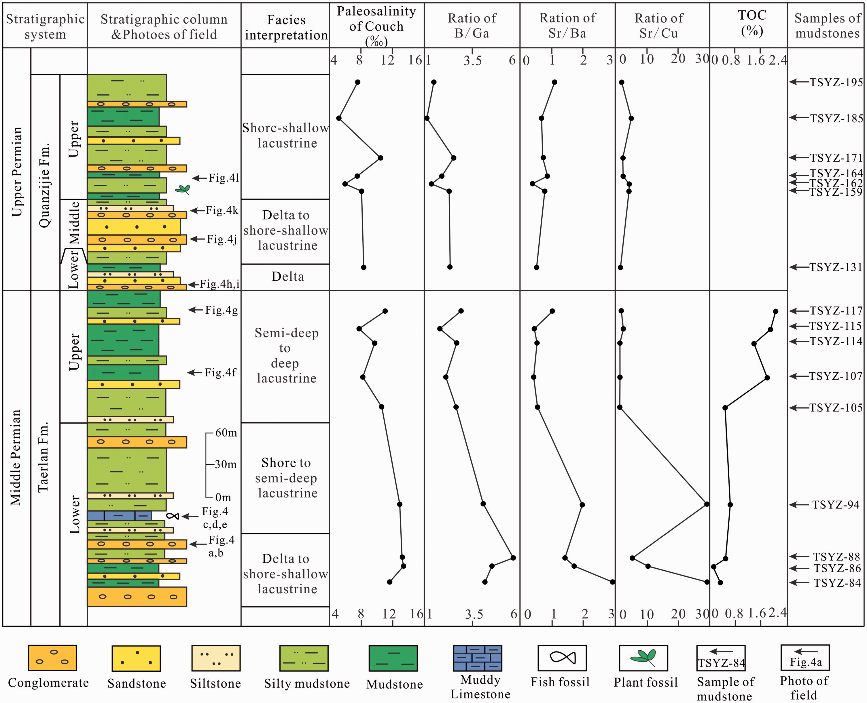
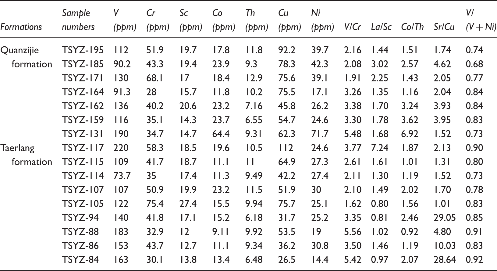
Sixteen dark mudstone samples were systematically collected from the bottom to top of the TSYZ section (Figure 3), and weathering rinds were removed. Figure 3 and Table 1 show the sample positions, numbers, and corresponding rock types.
Trace elements compositions, clay mineral contents, Paleosalinity analysis chart (×10−6), and Toc values of Middle–Upper Permian mudstones in the TSYZ profile, northwest Turpan–Hami Basin.
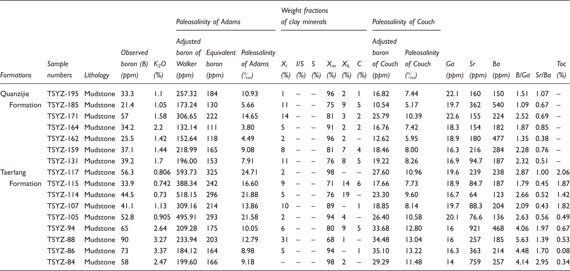
Note: Adjusted boron of Walker = Observed boron × 8.5/K2O, Paleosalinity of Adams = 0.0977 × Equivalent boron – 7.043 (Adams et al., 1965), Equivalent boron is calculated by the departure curves for computing equivalent boron (Walker and Price, 1963). Paleosalinity of Couch = 10(lg B* – 0.11)/1.28 (Couch, 1971). B* = Observed boron/(4XI + 2XM + XK). B*: Adjusted boron of Couch. XI = Xi + I/S × (1 – S), XM = Xm + I/S × S, XK = Xk. Xi, Xm, Xk, C: weight fractions of illite, montmorillonite, kaolinite, and chlorite, respectively, as determined by X-ray diffraction (Couch, 1971). I/S: mineral content of illite-smectite mixed layer. S: the content of smectite in I/S. Xi + Xm + Xk + I/S + C = 100%. B/Ga: ratio of observed boron to gallium, Sr/Ba: ratio of strontium to barium.
Nine samples from the Taerlang Formation and seven samples from the Quanzijie Formation were analyzed for the compositions of trace and rare earth elements and the contents of clay minerals. The trace and rare earth elements compositions of mudstones were tested by inductively coupled plasma mass spectrometry (ICP-MS), using a HR-ICP-MS (Element I) instrument (working under the temperature of 20°C, and humidity of 30%) following the standard of DZ/T0223–2001. The contents of clay minerals from mudstones were determined by X-ray powder diffractometer (XRD), using a Panalytical X‘Pert PRO MPD instrument (working under the voltage of 40kV, and electric currents of 40Ma) following the standard of SY/T5163–1995. All the tests were conducted at Analytical Laboratory of Beijing Research Institute of Uranium Geology. The analytical precision was better than 5%.
Nine mudstone samples from the Taerlang Formation for the compositions of Total organic carbon (TOC) were determined by American carbon-sulfur elemental analyzer (LECO-CS230) following the Chinese standard GB/T19145–2003. This test was conducted in the State Key Laboratory of Petroleum Resource and Prospecting, China University of Petroleum (Beijing).
Results
Sedimentological features
The Permian is well exposed in the foothills of Bogda Mountains, northwestern Turpan–Hami Basin. This study focuses on the Middle Permian Taerlang Formation and the Upper Permian Quanzijie Formation in the TSYZ profile in the southern foothill of the Bogda Mountains (Figure 1(b) and (c)). In this outcrop section, the thicknesses of the Taerlang and Quanzijie Formations are 295 m and 202 m, respectively.
Lithologic types
The Middle–Upper Permian is mainly composed of clastic rocks (containing conglomerate, sandstone, and argillaceous rocks) with carbonate rocks intervals in this study area (Figure 3).
Conglomerate: Conglomerates, mainly distributed in the Lower Taerlang Formation and Lower-Middle Quanzijie Formation (Figure 3), are commonly characterized by scour structures at the bottom (Figure 4(a), (h), and (j)). In general, the gravels in this lithofacies, mainly composed of volcanic rocks and sandstones, are characterized by sub-angular to sub-rounded shapes and poor sorting (Figure 4(b)). This lithologic type commonly evolves vertically to become sandstone or argillaceous rock (Figures 3 and 4(a), (b), (h), and (j)).
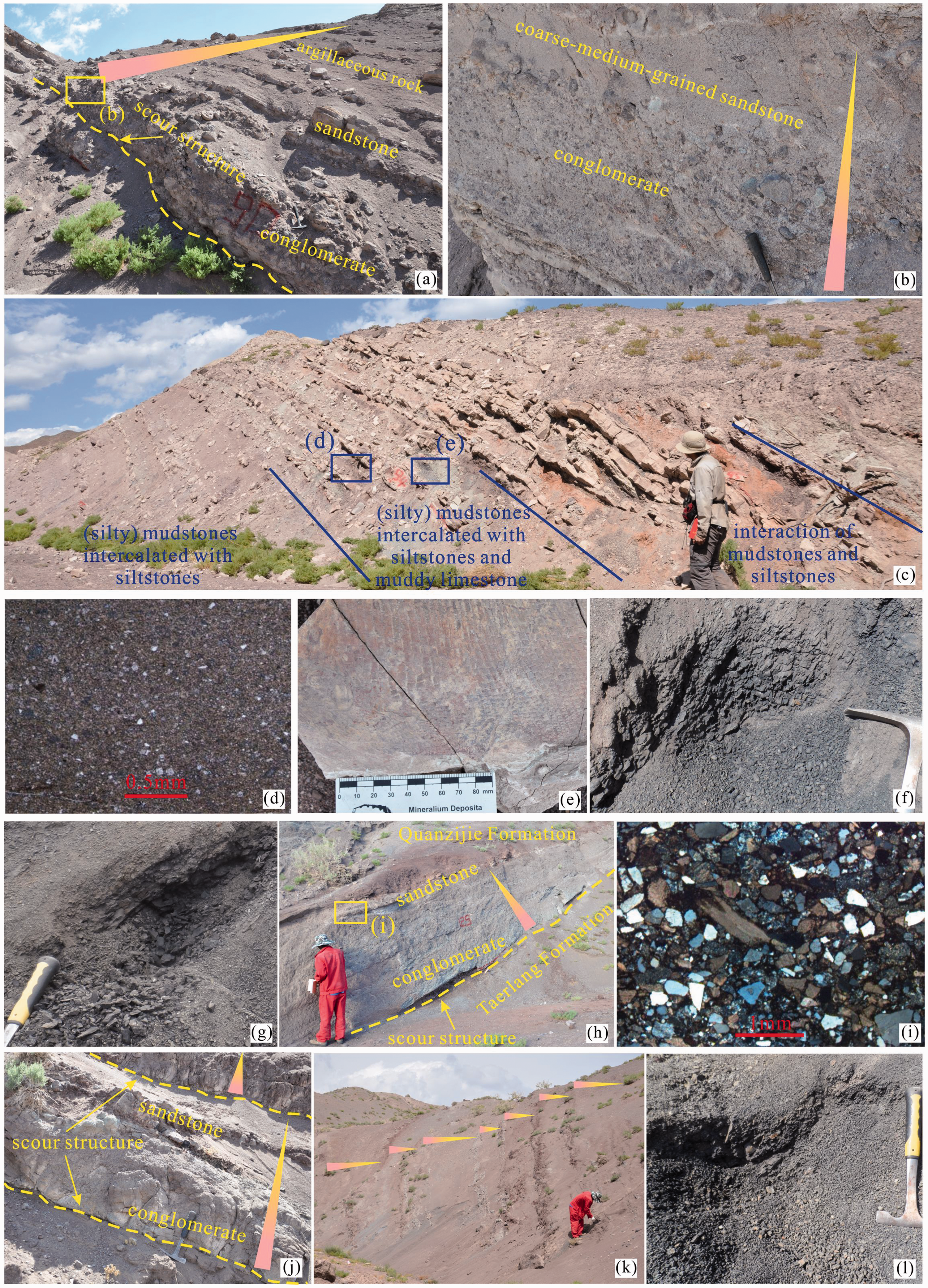
Sedimentary characteristics of the Middle–Upper Permian from the TSYZ profile. The locations where the photos were taken in the section can be seen from Figure 3. (a) Normal-graded, massive beds of clast-supported pebble conglomerates passing upward into sandstones and mudstones, commonly with scour structure at the bottom of conglomerates, delta facies, Lower Taerlang Formation. (b) The gradual retrogradation trend, conglomerate passing upward into sandstone, delta facies, Lower Taerlang Formation. Gravels in the conglomerates are mainly composed of volcanic rocks and sandstones and are characterized by sub-angular to sub-rounded shapes and poor sorting. (c) Alternating layers of mudstones, silty mudstones, siltstones and muddy limestones; alternating layers of semi-deep and shore-shallow lacustrine facies, Lower Taerlang Formation. (d) The microscopic photo of muddy limestone, minor quartz fragments contained in this lithofacies, shallow lacustrine facies, Lower Taerlang Formation. (e) Fish fossil preserved in muddy limestone, shallow lacustrine facies, Lower Taerlang Formation. (f) Dark mudstones, semi-deep to deep lacustrine facies, Upper Taerlang Formation. (g) Dark gray silty mudstones, semi-deep to deep lacustrine facies, Upper Taerlang Formation. (h), (j) Normal-graded, massive beds of clast-supported fine-pebble conglomerates passing upward into sandstones, commonly with scour structure at the bottom of conglomerates, delta facies, (h) Lower Quanzijie Formation, (j) Middle Quanzijie Formation. (i) Fine-grained sandstone. Grains in this lithofacies, commonly characterized by poor psephicity (angular shapes) and poor sorting, mainly include fragments of volcanic rocks, feldspars and quartzs. Grain contacts mainly include point and line types. (k) Multiple alternating layers of coarse- and fine-grained deposits, shore-shallow lacustrine facies, Middle Quanzijie Formation. (l) Dark gray mudstones, shallow lacustrine facies. The plant fossil preserved in the underlying silt mudstones of this mudstone layer, Upper Quanzijie Formation.
Sandstone: The distribution abundance of sandstones is much similar to that of conglomerates in the study section (Figure 3). This lithologic type can be subdivided into coarse-medium-grained sandstone, fine-grained sandstone, and siltstone. Grains contained in this lithofacies mainly include fragments of volcanic rocks, feldspars and quartzs (Figure 4(i)). They commonly show features of the poor psephicity (angular shapes) and poor sorting (Figure 4(i)). The grain-contacts are mostly point-linear contacts in this lithofacies (Figure 4(i)). With the decrease in detrital particles, the coarse-medium-grained sandstone commonly evolves vertically to become fine-grained sandstone, siltstone, or argillaceous rocks (Figure 4(k)).
Argillaceous rock: Argillaceous rock is one of the most important lithofacies in this area (Figure 3), mainly including dark gray-dark mudstone (Figure 4(f) and (l)) and silty mudstone (Figure 4(g)). These lithofacies are commonly interbedded with conglomerates or sandstones in the Lower Taerlang Formation and Lower-Middle Quanzijie Formation (Figures 3 and 4(a) and (k)). Partial plant fossil is observed within the silty mudstone in the Upper Quanzijie Formation (Figure 3).
Carbonate rock: The distribution abundance of carbonate rock is much lower than those of clastic rocks. This lithofacies only occurs in the Lower Taerlang Formation and appears as intervals in this section (Figure 3). The muddy limestone is the only lithologic type of carbonate rock observed in this area. Minor quartz fragments can be observed in thin-sections of this lithofacies (Figure 4(d)). Moreover, fish fossil is well-preserved in this lithofacies (Figures 3 and 4(c) and (e)).
Facies types
Four sedimentary facies types (i.e. delta, shore, shallow lacustrine, and semi-deep to deep lacustrine) are identified in the Middle–Upper Permian successions. The characteristics of these types can be described as follows:
Delta facies: The lithofacies association of this facies is commonly characterized by interactions of conglomerate, sandstone, or argillaceous rocks (Figure 4(a), (h), and (j)). In general, conglomerate grades upward into sandstone or argillaceous rock, showing an obvious regression trend. Scour structures can be obviously observed at the bottom of conglomerates (Figure 4(a), (h), and (j)).
Shore facies: The lithofacies association of the shore facies mainly includes coarse-medium-grained sandstone and fine-grained sandstone (Figure 4(k)). Upwards, the lithofacies of this facies commonly evolves to be shallow lacustrine siltstone or argillaceous rocks, showing an obvious regression trend (Figure 4(k)).
Shallow lacustrine facies: The lithofacies association of the shallow lacustrine facies predominantly comprises siltstone, silty mudstone, and mudstone (Figure 4(l)) with some muddy limestone intervals (Figure 4(c) to (e)). Fish and plant fossils are well preserved in the muddy limestone (Figure 4(e)) and silty mudstone of the shallow lacustrine facies, respectively.
Semi-deep to deep lacustrine facies: This facies is mainly distributed in the Upper Taerlang Formation (Figure 3). The lithofacies association of this facies mainly includes dark mudstone (Figure 4(f)) and silty mudstone (Figure 4(g)).
Sedimentary evolution
Taerlang Formation: The Lower Taerlang Formation is dominated by a series of alternating layers of coarse- and fine-grained deposits interbedded with a few carbonate rocks and characterized by delta and shore to semi-deep lacustrine facies (Figures 3 and 4(a) to (e)). Coarse-grained deposits with scour structures at the bottom are commonly composed of deltaic grey conglomerates and sandstones, and grade upward into the shore-shallow lacustrine fine-grained dark grey siltstones, silty mudstones, and mudstones, which suggests a gradual retrogradation trend (Figures (3) and 4(a)). Upwards, the thicknesses and numbers of coarse-grained layers gradually decrease, which is probably influenced by the lake level rise. The lithofacies assemblage evolves vertically to be a shore to semi-deep lacustrine succession of alternating layers of mudstones, silty mudstones, siltstones, and muddy limestones (Figures 3 and 4(c) to (e)).
As the lake level continuously increased, the successions retrograde into the semi-deep to deep lacustrine finer grained sediments (i.e. dark gray or dark mudstones and silty mudstones, Figures 3 and 4(f) and (g)) interbedded with shore-shallow lacustrine dark gray silty mudstones and gray fine sandstones of the Upper Taerlang Formation (Figure 3).
Quanzijie Formation: Influenced by the regional tectonic uplift, the top of the Taerlang Formation ends up with a sharp scour surface (Figures 3 and 4(h)). The fining-upward delta sedimentary succession (Figures 3 and 4(h)) of the lowermost Quanzijie Formation is observed above the boundary.
The Middle Quanzijie Formation is characterized by the alternating layers of delta (Figures 3 and 4(j)) and shore-shallow lacustrine deposits (Figures 3 and 4(k)), which is caused by intermittent lake level fluctuations.
With the slight increase of the lake level rate, the majority of the Upper Quanzijie Formation with a series of shore-shallow lacustrine intercalated with delta depositions is composed of dark or dark gray mudstones and silty mudstones (i.e. shore-shallow lacustrine facies) (Figures 3 and 4(l)) interbedded with yellow-green conglomerates and sandstones (i.e. delta facies) (Figure 3).
Geochemical characteristics of mudstones
Trace elements
Table 1 lists the analytical results of the observed boron (B), gallium (Ga), strontium (Sr), and barium (Ba) contents and the B/Ga and Sr/Ba ratios in the 16 investigated mudstone samples. Generally, the ratios of B/Ga and Sr/Ba gradually decrease from the Lower Taerlang Formation to the Upper Quanzijie Formation, respectively (Table 1, Figure 3).
Clay minerals contents
As presented in Table 1, the mudstone samples from the Taerlang and Quanzijie Formations have complex clay mineral compositions, which are mainly composed of montmorillonites and minor illite, kaolinite and chlorite. Montmorillonite comprises more than half of the total clay minerals, with a range of 68–98%. Weight fractions of the illite and kaolinite clay minerals in these mudstones are lower than 31% and 19%, respectively. Chlorite is present in minor amounts (<6%).
TOC values
TOC values of the Taerlang Formation mudstones, listed in the Table 1, vary between 0.08% and 2.06% and show stepwise increases upward in this profile (Figure 3). TOC values in the Lower Taerlang and Upper Taerlang Formations mudstones range from 0.08% to 0.67% (samples TSYZ-84 to TSYZ-94) and from 0.49% to 2.06% (samples TSYZ-105 to TSYZ-1117), with an average of 0.41% and 1.53%, respectively.
Rare earth elements
Contents of the rare earth elements: The analytical results of rare earth elements (REE) composition for the Middle–Upper Permian mudstones are presented in Table 2. Total concentrations of REE (ΣREE), contents of the light REEs (LREEs), and concentrations of the heavy REEs (HREEs) of the Taerlang and Quanzijie Formations are also calculated, respectively. The data show that the averages of ΣREE (173 ppm and 171 ppm, respectively), LREEs (149 ppm and 148 ppm, respectively), and HREEs (23.7 ppm and 23.2 ppm, respectively) in the Taerlang and Quanzijie Formations are similar in this area, respectively. The ratios of ΣLREE/ΣHREE, LaN/YbN, LaN/SmN and GdN/YbN in the 16 investigated mudstone samples (Table 2) consistently suggest that the LREEs are well enriched in relative to HREEs in this area.
Rare earth elements compositions (×10−6) of Middle–Upper Permian mudstones in the TSYZ profile, northwest Turpan–Hami Basin.
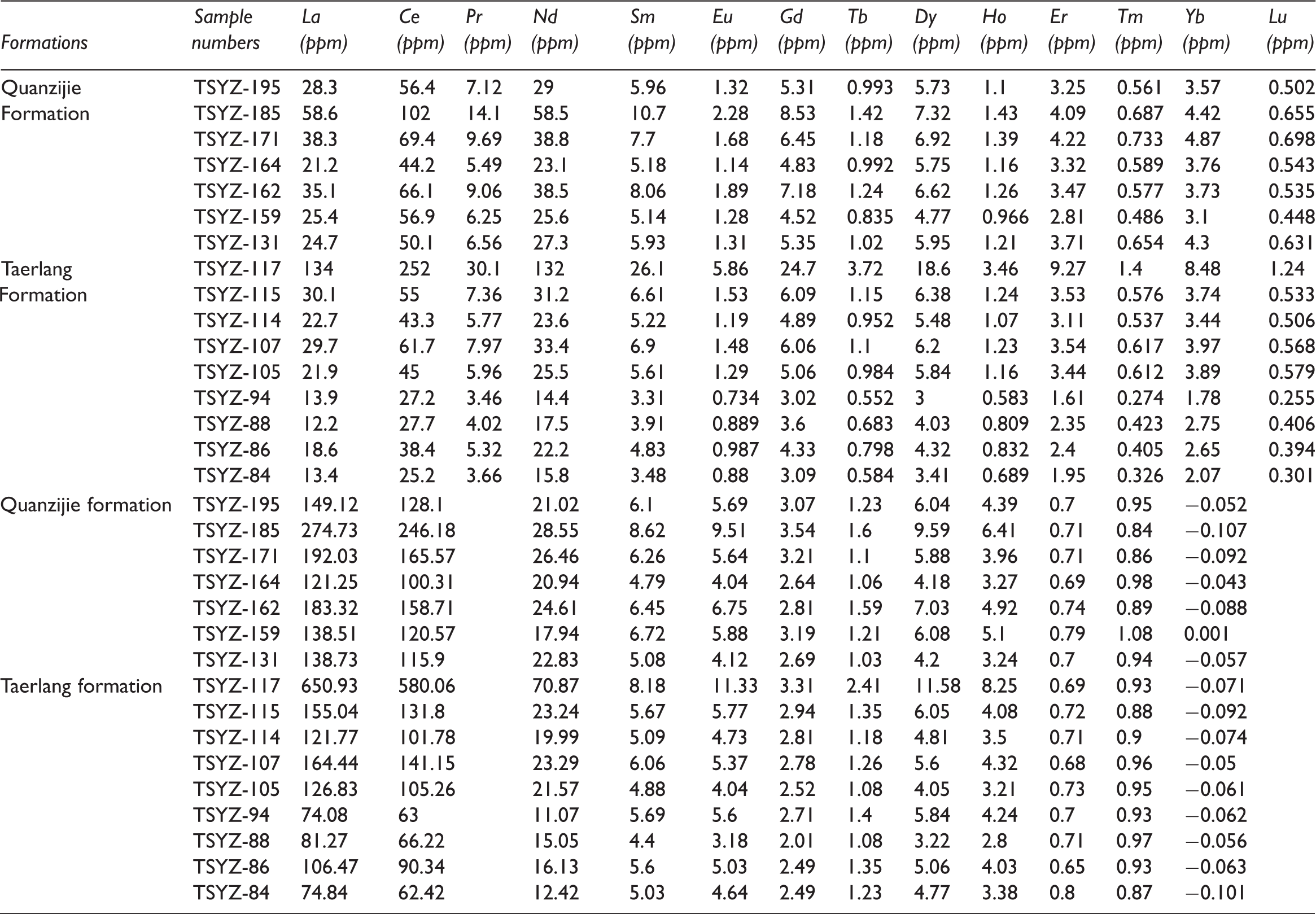
ΣLREE: total content of light rare earth elements (ΣLREE = La + Ce + Pr + Nd + Sm + Eu); ΣHREE: total content of heavy rare earth elements (ΣHREE = Gd + Tb + Dy + Ho + Er + Tm + Yb + Lu); ΣREE: total content of rare earth elements (ΣREE = ΣLREE + ΣHREE); N: chondrite-normalized; n: NASC-normalized; NASC: North American Shale Composite; δEuN = EuN/(SmN × GdN)1/2, EuN, SmN and GdN represent the chondrite-normalized value; δCeN = CeN/(LaN × PrN)1/2, CeN, LaN and PrN represent the chondrite-normalized value; Ceanom = Lg [3Cen/(2Lan + Ndn)], Cen, Lan, Prn and Ndn represent the NASC-normalized value; Data source: Chondrite (Boynton, 1984); NASC (Haskin and Haskin, 1968).
The chondrite-normalized patterns: The chondrite-normalized patterns of the REE concentrations in mudstones are presented in Figure 5. All of the samples from Taerlang and Quanzijie Formations show a similar distribution trend. The chondrite-normalized REE distribution patterns of all mudstone samples show distinctly declining LREE trend and relatively flat HREE trend, which is consistent with the feature that LREEs are enriched and HREEs are deficient as described above. Furthermore, these curves all show a negative Eu anomaly (lower than 0.80) and negligible Ce anomaly (higher than 0.84) in the Taerlang and Quanzijie Formations (Table 2 and Figure 5). All of these results reflect that the REEs of these mudstone samples might have been derived from a similar terrigenous source.
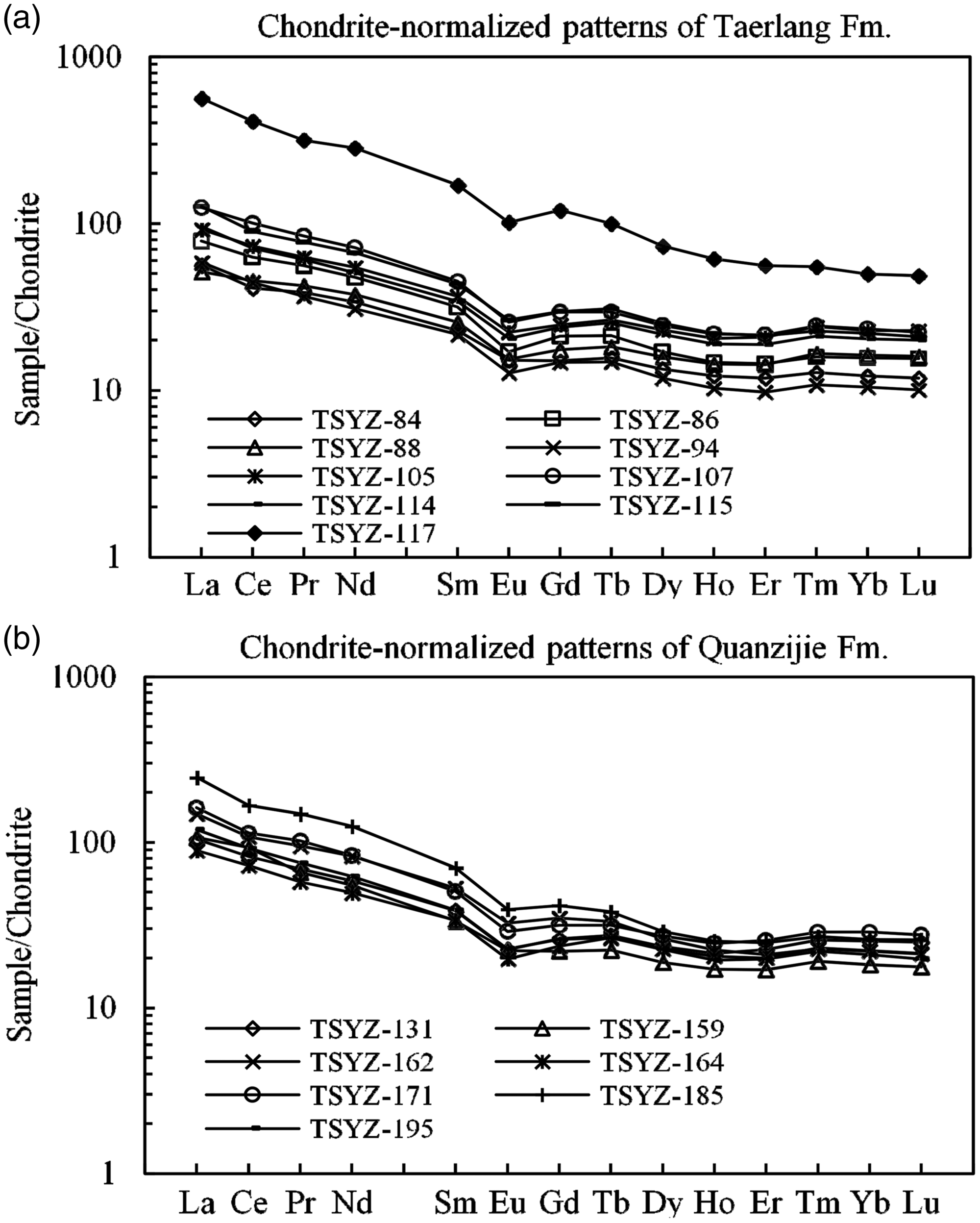
Chondrite-normalized REE distribution patterns of the mudstones from the Taerlang and Quanzijie Formations (after Taylor and McLennan, 1985).
Discussion
Diagenesis
Shields and Stille (2001) noted that diagenesis could affect the Ce anomalies and result in a stronger positive correlation Ce/Ce*P with Eu/Eu*P as well as Ce/Ce*P with ΣREE, and a negative correlation Ce/Ce*P with DyP/SmP (where P refers to normalization of concentrations against the shale standard PAAS (McLennan, 1989)). Correlation results show that the Ce/Ce*P has a relatively poor correlation with Eu/Eu*P, as well as ΣREE, but a relatively good correlation with DyP/SmP (Figure 6) in this region, which reflects that the mudstones might have undergone weak diagenesis. In addition, the ratio of V/Cr lower than 2.0 reflects that the sediments have experienced a certain degree of diagenesis (Trueman and Tuross, 2002). The V/Cr ratios of mudstones (except for samples TSYZ-105 and TSYZ-171) from the Taerlang and Quanzijie Formations are all higher than 2.0 (Table 3), also suggesting that mudstones are in an overall weak diagenetic modification in this area. Miao (2001) noted that the vitrinite reflectances (Ro) of the Middle-Later Permian mudstones from the Northwest Turpan–Hami Basin were mainly lower than 1.0. These results indicated that these mudstones were mainly in a low-mature to mature stage. With the enhancement of diagenesis, point, line, and concave–convex types of the grain contacts can be observed successively (Ying et al., 2003). Grain contacts of the sandstones in the study area mainly include point and line types (Figure 4(i)). All of the above results indicate that the Middle-Upper Permian in the Northwest Turpan–Hami Basin might have undergone a relatively weaker diagenesis.
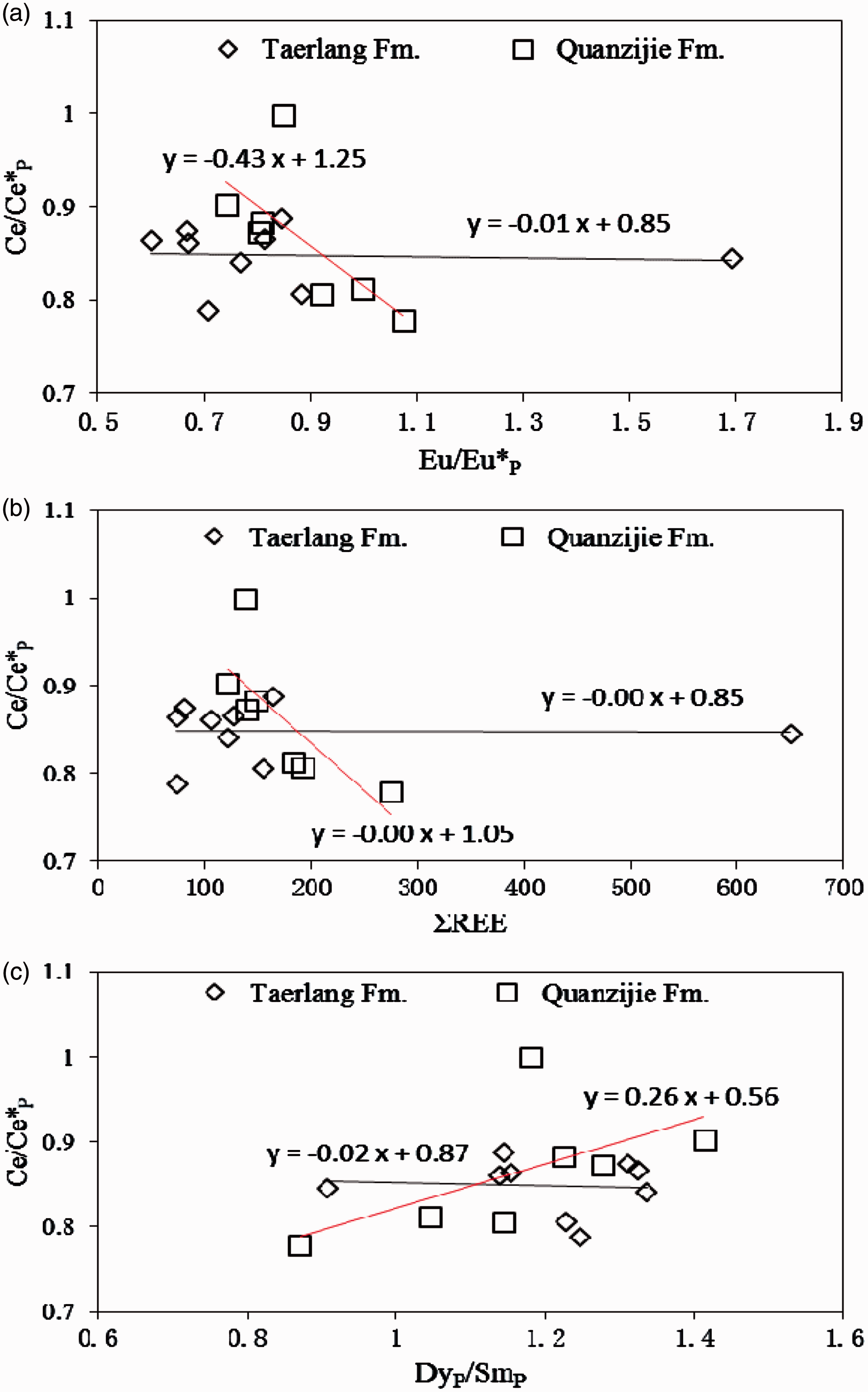
Plots of Ce anomalies (Ce/Ce*N) to Eu anomalies (Eu/Eu*N) (a), bulk REE (ΣREE) (b), and DyN/SmN ratios (c) calculated from the PAAS-normalized REE abundances of mudstones from the TSYZ profile. Black line: Taerlang Formation mudstones. Red line: Quanzijie Formation mudstones.
Elements characteristic values of Middle–Upper Permian mudstones in the TSYZ profile, northwest Turpan–Hami Basin.
Provenance
Certain elements (such as REE, Co, Th, La, and Sc) in the clastic rocks have very low mobile abilities and are probably quantitatively moved to the clastic sediments during the weathering, erosion, transportation, deposition, and diagenesis processes. The contents and ratios of these elements would therefore be useful to trace the material source of sediments and infer the provenance composition (Armstrong-Altrin et al., 2004; Asedu et al., 2000; Bai et al., 2015; Bhatia and Crook, 1986; Charles et al., 2008; Long et al., 2008; McLennan, 1989; McLennan et al., 1993; Tao et al., 2014). The REEs of these mudstone samples from the Taerlang and Quanzijie Formations are characterized by similar features of the chondrite-normalized REE abundances and distribution patterns, that is distinctly LREE enriched, HREE deficit, negative Eu anomalies and negligible Ce anomalies (Figure 5), reflecting that the REEs of these mudstone samples might have been derived from an identical terrigenous source. In general, felsic rocks show high LREE/HREE ratios and negative Eu anomalies, whereas mafic rocks usually show low LREE/HREE ratios and no Eu anomalies (Bai et al., 2015; Charles et al., 2008; Roddaz et al., 2006; Taylor and McLennan, 1985). The aforementioned chondrite-normalized abundances and patterns suggest that the provenance compositions of the both formations are mainly felsic volcanic rocks. Furthermore, diagram of La/Sc–Co/Th has also been widely used to determine the source rocks (McLennan et al., 1993; Wronkiewicz and Condie, 1987). In the plots of La/Sc–Co/Th, all points are distributed between the area of the felsic volcanic rocks and andesites (Table 3 and Figure 7), reflecting that andesites also might be included into the source rocks of the mudstones.
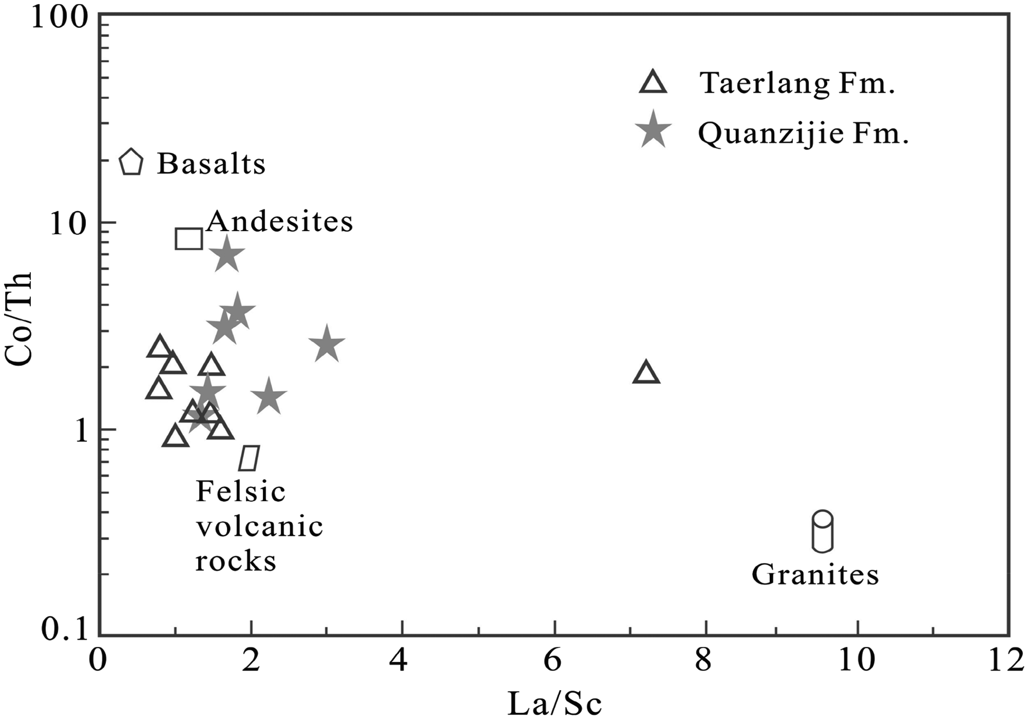
Diagram of La/Sc–Co/Th for mudstones in the study area (Base map sources: McLennan et al., 1993). Data are reported in Table 3.
Shao et al. (1999) and Xu et al. (2013) noted that the Permian lithic sandstone was one of the most important clastic rock types, and the debris within the sandstone were mainly composed of andesites and acid lavas in this region. The pebble components of the Permian conglomerates in the northwestern Turpan–Hami Basin were mainly characterized by andesites and rhyolites (Xu et al., 2013). The Young Tian Shan arc (Jueluotage Moutain area now) to the south was the primary provenance, whereas rift shoulder (Bogda Mountain area now) to the north was a local source for the Turpan–Hami Basin during the Permian (Wartes et al., 2002; Obrist-Farner and Yang, 2017). The location of the TSYZ section near the rift shoulder to the north but far from the Young Tian Shan arc to the south (Wartes et al., 2002) and the southeast paleocurrent direction during the Middle–Late Permian (Xu et al., 2013) indicate that the provenance for the study area was mainly from the rift shoulder to the north.
In conclusion, the provenance of the Middle–Upper Permian in the study region was mainly derived from the rift shoulder to the north and might be composed of a mixture of andesite and felsic volcanic source rocks.
Paleoclimate
As widely acknowledged, aspects of paleoclimate could be inferred from the paleontological features and certain trace elements compositions in sedimentary rocks (Leman, 1989; Liu and Zhou, 2007; Wang et al., 1997; Wei et al., 2016; Worash, 2002; Xu et al., 2012).
The fossil wood assemblage from the Taerlang Formation is characterized by a mixture of wood samples both with and without growth rings in the northeast Turpan–Hami Basin, suggesting that the paleoclimate of this basin was a relatively warm and humid climate with seasonal variations and unstable conditions during the Middle Permian (Wei et al., 2016). In addition, the characteristics of paleontology and lithofacies paleogeography indicate that the paleoclimate of Turpan–Hami Basin belonged to the North Temperate Zone, and was warm and humid climate during the Middle Permian (Yan et al., 2005). The reconstruction map of global paleoclimate also shows that the study area was located in a transitional climate belt between tropical–subtropical and cold temperate zones during the Middle–Late Permian (Boucot et al., 2009).
The variations of Sr/Cu value in sedimentary rocks have been widely used to reflect the ancient climate (Leman, 1989; Liu and Zhou, 2007; Wang et al., 1997; Xu et al., 2012). Ratios of Sr/Cu higher than 5.0 indicate dry and hot climate, whereas 1.3–5.0 reflect warm and humid climate (Leman, 1989; Liu and Zhou, 2007; Wang et al., 1997). As shown in Table 3, ratios of Sr/Cu from the Lower Taerlang Formation (i.e. samples from TSYZ-84 to TSYZ-94 that vary from 4.8 to 29.1, with an average of 18.1) show high and scatter values (Figure 3), indicating a relatively hot–dry climate with unstable conditions, while those of the Upper Taerlang Formation (i.e. samples from TSYZ-105 to TSYZ-117 that vary from 1.01 to 2.13, with an average of 1.53) show a lower value and stable characteristic (Figure 3), suggesting a relatively humid climate with stable conditions. In the Quanzijie Formation, the ratios of Sr/Cu range between 1.52 and 4.62, with an average of 2.84, showing a similar characteristic with the Upper Taerlang Formation (Figure 3), also indicating a relatively humid and stable climate.
All evidences above indicate that the study area was located in the North Temperate Zone (a transitional climate belt between tropical–subtropical and cold temperate zones), with warm and humid climate, seasonal variations and unstable conditions during the Middle–Late Permian. During the early Middle Permian (i.e. the period of Lower Taerlang Formation), the study area was a relatively hot–dry climate with unstable conditions. A relatively humid climate with stable conditions was primarily developed during the late Middle Permian to Late Permian (i.e. the period of Upper Taerlang and Quanzijie Formations).
Paleosalinity and controlling factors
Paleosalinity values
The contents of observed boron, K2O, and clay minerals were used to recover the paleosalinity of deposition medium (Adams et al., 1965; Couch, 1971; Liu, 1980; Liu and Zeng, 1985; Song et al., 2012; Walker, 1968; Walker and Price, 1963). Generally, two major methods, the Adams et al. (1965) method and the Couch (1971) method, have been widely used to calculate the paleosalinity values of the depositional environment. Based on the method suggested by Adams et al. (1965), paleosalinity values for all the mudstone samples in the profile vary between 3.8‰ and 24.7‰, with an average of 12.3‰. Paleosalinity values of Adams are 8.98‰–24.7‰ (average 15.5‰) and 3.8‰–14.7‰ (average 8.07‰) in the Taerlang and Quanzijie Formations, respectively (Table 1). The paleosalinity values calculated based on the method suggested by Couch (1971) vary from 5.17‰ to 13.2‰, with an average of 9.39‰ for all the mudstone samples. Paleosalinity values of Couch in the Taerlang and Quanzijie Formations vary from 7.73‰ to 13.2‰ and 5.17‰ to 10.4‰, with an average of 10.8‰ and 7.52‰, respectively (Table 1).
The adsorption capacity to boron varies for the different clay minerals. Illite has the strongest absorption capacity to boron within the clay minerals. The main drawback of Adams’ method is that the derived Adams’ paleosalinity strongly relies on the abundance of illite and is suitable for these samples whose main clay mineral is illite (Adams et al., 1965). The main clay mineral of these mudstones is montmorillonite which shows that the Adams’ method might be unreliable to calculate paleosalinity for these samples in the study area.
Couch’s method used to calculate the paleosalinity values can well eliminate the influence of clay mineral compositions to boron and is extensively used for samples with complex clay mineral compositions (Couch, 1971; Wen et al., 2008). As previously mentioned, the mudstone samples of the Middle–Upper Permian have complex clay mineral compositions (including illite, montmorillonite, kaolinite, and chlorite). However, burial diagenesis has an impact on the boron content of clay by altering the relative proportion of clay minerals (Ye et al., 2016). This can consequently affect the paleosalinity measured by Couch’s method. The diagenesis analysis indicated that the mudstone samples in the study area have undergone an overall weak diagenesis. So the diagenetic effect for the paleosalinity measured by Couch’s method is relatively small. These pieces of evidences suggest that the Couch’s method is more applicable to recovering the paleosalinity in this area.
Moreover, several studies have shown that the value of B/Ga and Sr/Ba can effectively reflect the paleosalinity characteristics of depositional environment and have significant positive correlation with paleosalinity (Wang et al., 2014; Song et al., 2012; Xu et al., 2012; Zheng and Liu, 1999; Zhang and Zhang, 2006). The ratio of B/Ga and Sr/Ba has relatively poor correlation with the paleosalinity of Adams (Figure 8) but a relatively positive correlation with the paleosalinity of Couch (Figures 3 and 9) in this region. This finding also indicates that the paleosalinity calculated using Couch’s method is more reliable than that using Adams’ method for these mudstone samples in the study area.
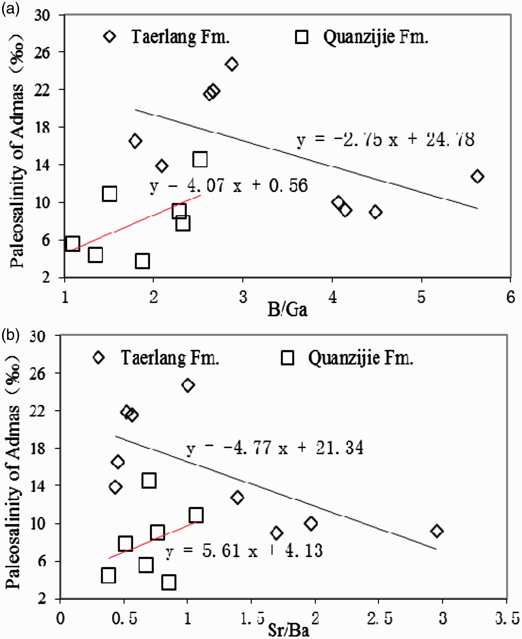
Relationship between ratio of B/Ga (a), Sr/Ba (b) and paleosalinity of Admas. Data are reported in Table 1. Black line: Taerlang Formation mudstones. Red line: Quanzijie Formation mudstones.
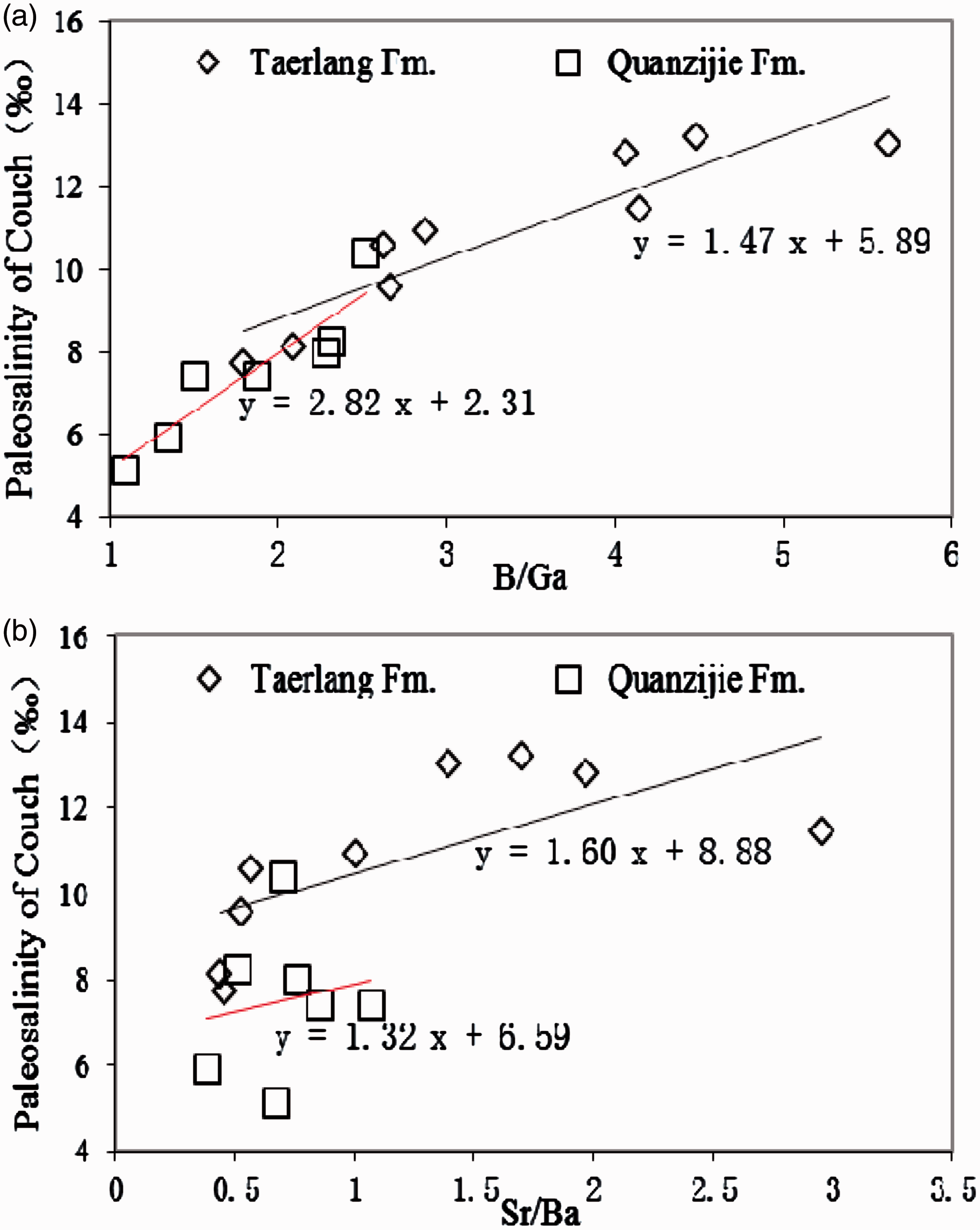
Relationship between ratio of B/Ga (a), Sr/Ba (b) and paleosalinity of Couch. Data are reported in Table 1. Black line: Taerlang Formation mudstones. Red line: Quanzijie Formation mudstones.
The criteria of paleosalinity indicate that a value higher than 50.0‰, 15.0‰–50.0‰, 5.0‰–15.0‰, 1.0‰–5.0‰, and lower than 1.0‰ corresponds to brine, saltwater, semi-saline water, brackish water, and freshwater depositional environment, respectively (Huang and Li, 1982). The aforementioned paleosalinity values of Couch (Table 1) suggest a semi-saline water depositional environment for the Middle–Upper Permian mudstones. As shown in Figure 3, the values of paleosalinity measured using Couch’s method show stepwise decreases from the Lower Taerlang Formation to the Upper Quanzijie Formation.
Controlling factors of the paleosalinity evolution
Climate variability is the main factor that influences the paleosalinity of sedimentary water in lake basins. Generally, during the hot–dry climate period, high evaporation rates and rare freshwater injection result in a relatively high paleosalinity value of depositional environment (Ye et al., 2016), whereas the considerable decrease in evaporation and increase in precipitation during the moist climate stage result in the desalination of sedimentary water.
Figure 3 shows that the paleosalinity fluctuations of the Taerlang and Quanzijie Formations correspond relatively well with the paleoclimatic evolution. During the period of Lower Taerlang Formation, the study area belonged to a hot–dry paleoclimate environment, which is reflected by the ratio of Sr/Cu, that corresponds to a paleoenvironment with relatively higher paleosalinity value (i.e. samples from TSYZ-84 to TSYZ-94 that are higher than 11‰, as shown in Table 1) (Figure 3). However, the paleoclimate transited into a relatively humid condition when the Upper Taerlang Formation started to deposit, and the lake basin gradually evolved to be a relatively lower saline (i.e. samples from TSYZ-105 to TSYZ-117 that are lower than 11‰, as shown in Table 1) (Figure 3). The Quanzijie Formation was also developed in a humid climate, which is similar to the Upper Taerlang Formation, thereby continuously decreasing the overall salinity of the paleoenvironment (Figure 3). All these features suggest that the paleosalinity fluctuations were mainly influenced by the changes of paleoclimate during the Middle–Late Permian in the study area.
Redox condition
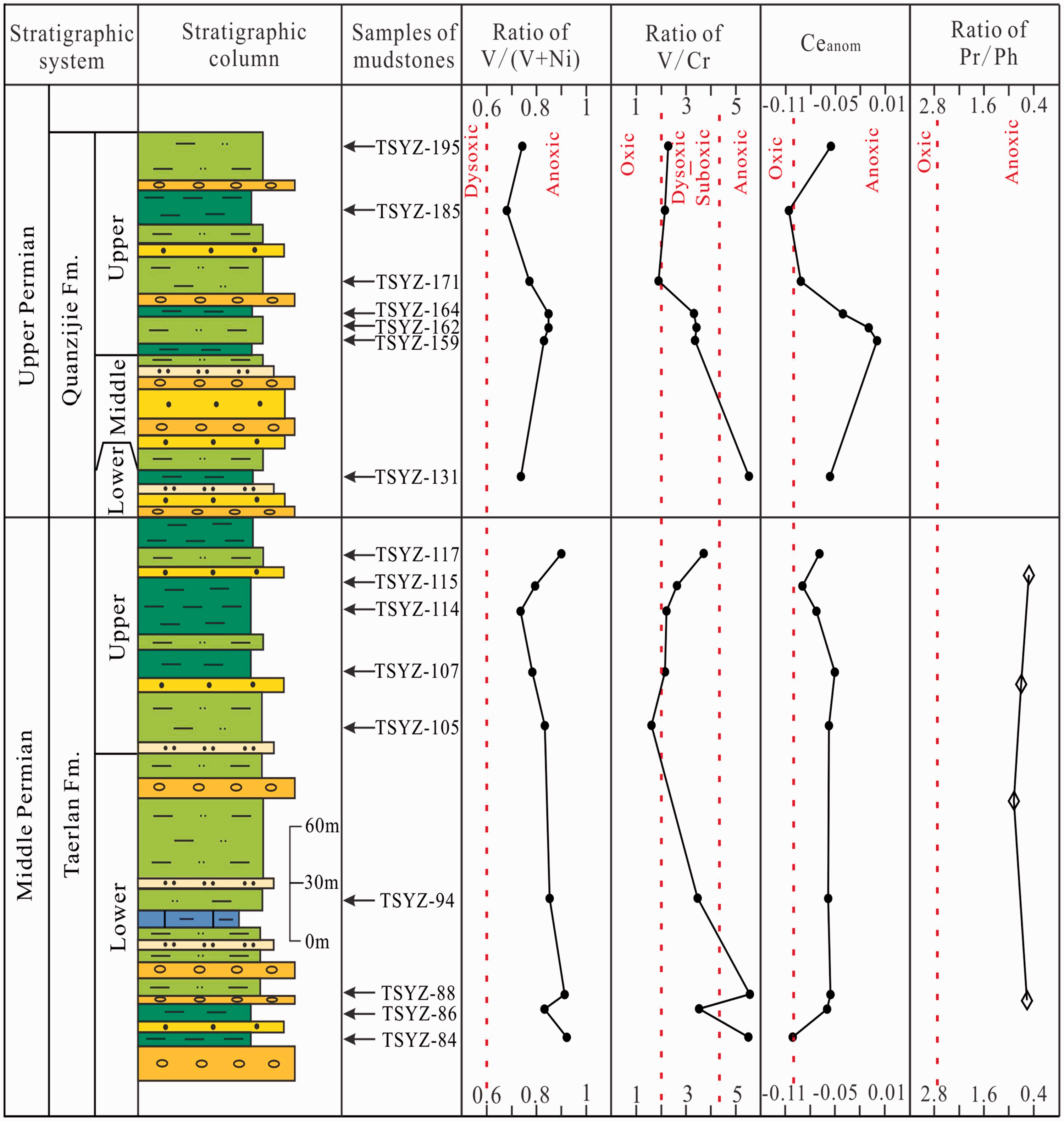
The V/(V + Ni) and V/Cr ratios have been widely used to indicate the redox conditions of the depositional environment (Hatch and Leventhal, 1992; Jones and Manning, 1994). Previous studies showed that ratios of V/(V + Ni) higher than 0.84, 0.54–0.82, 0.46–0.60, and lower than 0.46 suggest strongly anoxic, anoxic, dysoxic, and oxic depositional environment, respectively (Hatch and Leventhal, 1992). With regard to ratios of V/Cr, values higher than 4.25, 2.0–4.25, and lower than 2.0 suggest anoxic, suboxic to dysoxic, and oxic depositional environment, respectively (Jones and Manning, 1994). In the study area, the ratios of V/(V + Ni) from the Taerlang and Quanzijie Formations range from 0.73 to 0.92 and from 0.68 to 0.84, with an average of 0.84 and 0.78, respectively (Table 3, Figure 10), indicating an anoxic depositional environment during the Middle–Late Permian. These characteristic values of V/Cr (Table 3) demonstrate that most mudstone samples were deposited in an overall dysoxic-anoxic depositional environment except certain samples (TSYZ-105 and TSYZ-171) deposited in an oxic depositional environment during the period of Taerlang and Quanzijie Formations (Figure 10).
Vertical distribution of geochemical data about redox condition for the Taerlang and Quanzijie Formations. Data are reported in Tables 2 and 3. The data of Pr/Ph ratios for mudstones were given by Zhang (2014) and the positions of these mudstone samples were speculative in this study. The lithologic legends are listed in Figure 3.
Wright et al. (1987) proposed the Ce variation (Ceanom) as an index of bottom water anoxia in ancient sedimentary sequences. When the Ceanom is higher than −0.1, it is indicative of an anoxic condition, while if the Ceanom is lower than −0.1, it marks an oxic condition (Wright et al., 1987). As presented in Table 2, the Ceanom of mudstones (except for samples TSYZ-84 and TSYZ-185) from the Taerlang and Quanzijie Formations is all higher than −0.1, suggesting that mudstones were deposited in an overall anoxic depositional environment in this area. However, the plot of Ce anomalies against Pr anomalies (Figure 11) demonstrates that most of the samples have pronounced negative Ce anomalies that are exaggerated by enrichments of La. Hence, the Ceanom values used to reflect the redox conditions of the depositional environment are unreasonable for the mudstones in the study area.
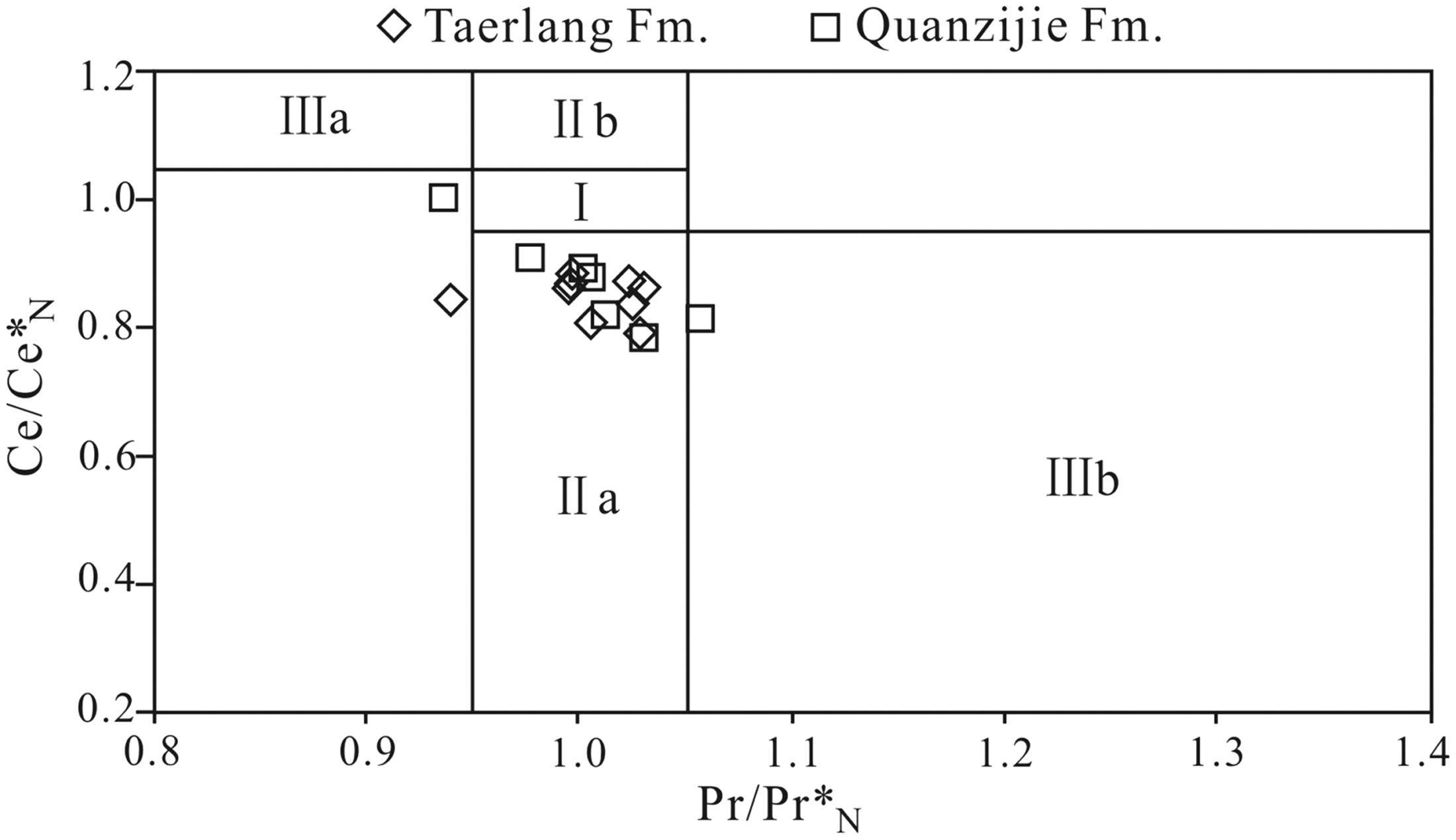
Plots of Ce anomalies (Ce/Ce*N) to Pr anomalies (Pr/Pr*N), where N refers to normalization of concentrations against the shale standard NASC (Haskin and Haskin, 1968). Field I, no anomaly; Field IIa, positive La anomaly causes apparent negative Ce anomaly; Field IIb, negative La anomaly causes apparent positive Ce anomaly; Field IIIa, real positive Ce anomaly; Field IIIb, real negative Ce anomaly (Shields and Stille, 2001).
Ratios of Pr/Ph can also reflect the redox conditions of the depositional environment (Mei and Liu, 1980; Ming et al., 2015). Commonly, the ratio of Pr/Ph lower than 0.80 suggests a strong reduction environment, and 0.80–2.8 marks a weak reduction environment, while higher than 2.8 indicates an oxic environment (Mei and Liu, 1980). By studying the mudstones of the Taerlang Formation in the TSYZ section, Zhang (2014) noted that the ratio of Pr/Ph ranges from 0.53 to 0.88, with an average of 0.69 (Figure 10), reflecting a reduced environment.
Furthermore, variegated colors of the deposits reflect changes in lake water oxygenation (Legler et al., 2011). Grey lake horizons probably form under the influence of dysoxic sedimentary environment (Legler et al., 2011). Massive lacustrine dark grey or dark mudstones and silty mudstones (Figures 3 and 4(f), (g), and (l)) mainly deposited in a relatively deeper water environment with a stratified water column are very developed, whereas the deposits with oxidized colors (i.e. red and purple) are relatively undeveloped in this region, which also marks an overall anoxic depositional environment.
Based on the discussions of redox-conditions referred from V/(V + Ni) ratios, V/Cr ratios, Pr/Ph ratios, and sediment characteristics, the conclusion could be drawn that the study area was an anoxic depositional environment on the whole during the Middle–Late Permian. This depositional environment was relatively favorable to the preservation of organic matter.
Paleoenvironmental and depositional reconstruction
This study reconstructs the paleoenvironment and depositional filling of Lower Taerlang Formation, Upper Taerlang Formation, and Quanzijie Formation in this region based on the aforementioned discussions of sedimentary characteristic, lake level fluctuation, provenance, paleoclimate, paleosalinity, and redox condition, which can be interpreted as follows (Figure 12).
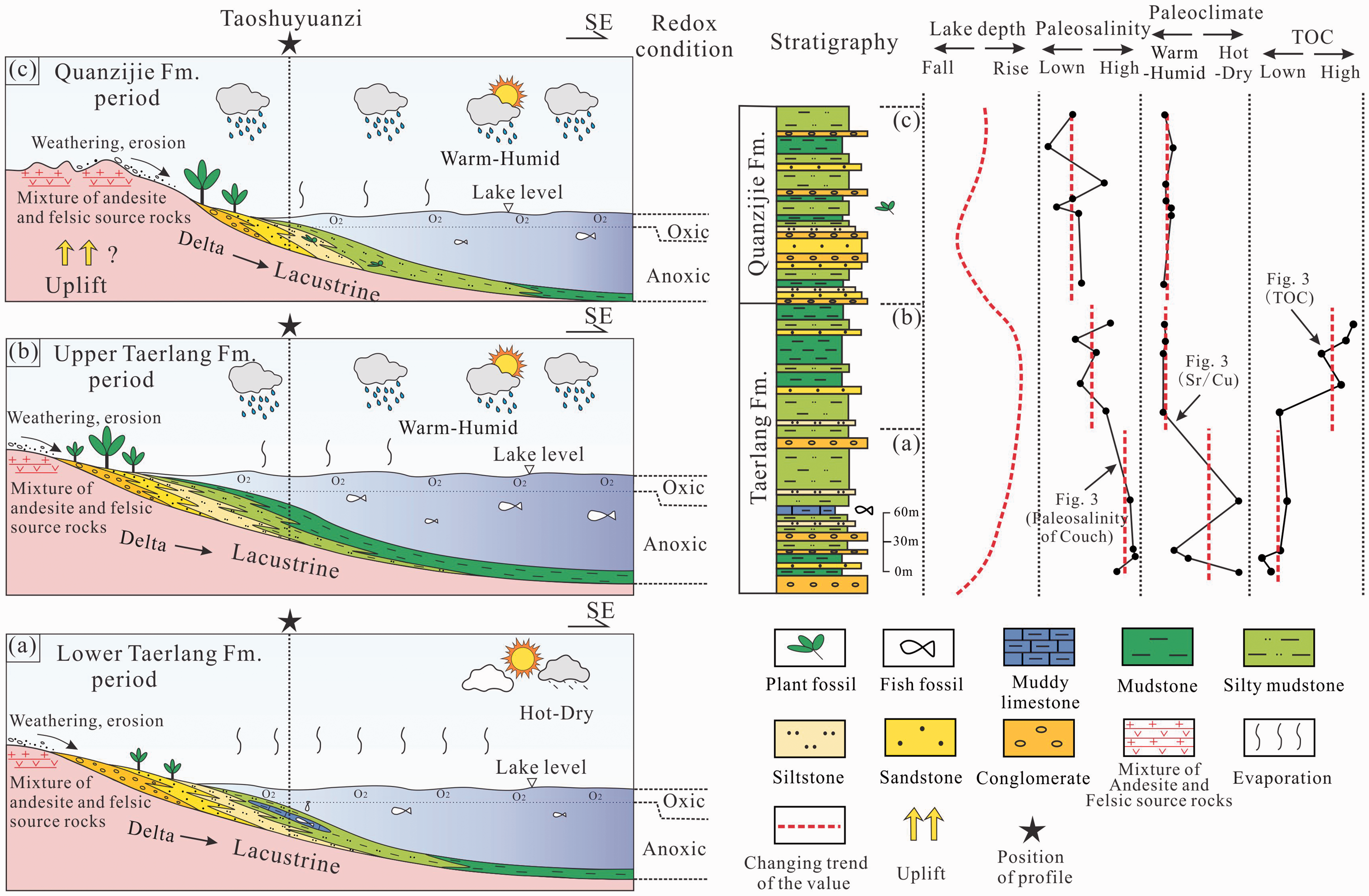
Paleoenvironmental and depositional reconstruction of Middle–Upper Permian in northwestern Turpan–Hami Basin.
During the deposition of Lower Taerlang Formation (i.e. stage (a)), the study area belonged to a hot–dry paleoclimate zone, with a high evaporation rate and possibly a relatively low rainfall rate, thereby causing a high paleosalinity water environment. The eroded parts of parental rocks (i.e. mixture of andesite and felsic source rocks) from the northern part of this area were transported into the lacustrine basin and formed the lower sedimentary successions of the Taerlang Formation (Figure 12(a)). The lower part of the Taerlang Formation was deposited in a delta environment with interactive deposits of conglomerates, sandstones, silty mudstones and mudstones (Figures 3 and 4(a)), and associated with a lake transgression it gradually changed into a lacustrine deposition (i.e. silty mudstones intercalated with muddy limestones, siltstones, and sandstones, Figures 3 and 4(c) to (e) upwards. An anoxic depositional environment was primarily developed during the deep-water sedimentation.
Compared with the previous stage (i.e. stage (a)), the sedimentary setting of the Upper Taerlang Formation (i.e. stage (b)) in this area evolved to be a warm–humid paleoclimate, characterized by weak evaporation, increased rainfall and decreased water salinity, but sharing similar provenance compositions. As the water table continuously increased, the successions retrograded into the lacustrine finer grained sediments of the Upper Taerlang Formation along the depositional profile (Figures 3, 4(f) to (g), and 12(b)). An overall anoxic depositional environment, which was conducive to the enrichment and preservation of organic matter for having a deep-water table, was observed in this area. The coarse-grained sediments might be deposited near the provenance region (Figure 12(b)).
The lake level became shallow rapidly during the period of the lowermost Quanzijie Formation (i.e. the early period of stage (c)) (Figure 12(c)), which was due to the regional tectonic uplift (Zhou, 2008). The characteristics of paleoclimate, evaporation, and provenance were similar to those for the Upper Taerlang Formation (i.e. stage (b)). The gradual decrease of paleosalinity was probably influenced by the weak evaporation and continuous rainfall. Moreover, interactions of fine- and coarse-grained deposits were developed frequently by the effect of intermittent lake level fluctuations in the TSYZ section (Figures 4(h) to (l) and 12(c)). The fine-grain sediments were supposed to be deposited in an anoxic environment.
Petroleum geological significance of the sedimentary environment
Generally, the sedimentary environment plays a critical role in the production and preservation of organic matter. Zhang et al. (2014) noted that the climate controlled rainfall which influenced the injection of terrigenous nutritional minerals, changes of salinity, and fluctuation of lake-level. The nutritional minerals and salinity in the water, together with lake-level, influenced the total number of microbes which controlled the organic matter productivity. The redox condition of depositional environment controlled the preservation of organic matter.
The Lower Taerlang Formation was deposited in a hot-dry climate (Figure 12). A relatively low injection of rainfall resulted in an overall lower lake-level (mainly delta to shore-shallow lacustrine facies in this area, Figures 3 and 12) but higher paleosalinity water environment. This sedimentary environment was relatively unbeneficial for the survival of microorganisms, leading to a relatively lower production of organic matter. Consequently, the mudstone of the Lower Taerlang Formation with low TOC value was formed in these conditions (Figure 12).
However, the sedimentary environment evolved to be warm–humid paleoclimate during the Upper Taerlang Formation period. This climate condition might increase the injection of rainfall leading the lake-level to rise (mainly semi-deep to deep lacustrine facies in this area, Figures 3 and 12), which increased the injection of terrigenous nutritional minerals and provided a larger living space for lake microbes. In addition, the warm–humid climate condition led to a relatively lower paleosalinity water environment. These conditions were favorable for the accumulation of microorganisms, resulting in a relatively higher organic matter productivity. Meanwhile, an overall anoxic depositional environment (Figure 10) was suitable for the preservation of these organic matters. Therefore, the mudstone of the Upper Taerlang Formation with high TOC value was deposited in these conditions (Figure 12).
The overall characteristic of sedimentary environment in the Quanzijie Formation was similar to that of the Upper Taerlang Formation (Figure 12). Hence, the conjecture that the mudstone of the Quanzijie Formation might also have high TOC value is deemed reasonable.
Conclusions
Complex vertical lithofacies assemblages of the Middle Permian Taerlang Formation and Upper Permian Quanzijie Formation were the primary characteristics in the Taoshuyuanzi (TSYZ) profile, northwest Turpan–Hami Basin, which were probably influenced by regional tectonism and frequent lake-level oscillations. Both formations have been derived from a similar terrigenous source (i.e. might be mixture of andesite and felsic source rocks) from a rift shoulder (currently known as Bogda Mountain area) to the north. Comprehensive analysis of geochemical data and petrological characteristics reflects that the mudstone samples overall have endured weak diagenesis, with some samples undergoing a certain degree of diagenesis in the study area.
The paleoclimate and paleosalinity changed gradually over time in the study area. This region belonged to relatively hot–dry and humid climate during the early Middle Permian (i.e. the period of Lower Taerlang Formation) and the late Middle Permian to Late Permian (i.e. the period of Upper Taerlang and Quanzijie Formations), respectively. The paleosalinity calculated using Couch’s method was more reliable than that using Adams’ method for the mudstone samples in the study area. The Middle–Upper Permian was deposited in an overall semi-saline water sedimentary environment. From the Lower Taerlang Formation to the Upper Quanzijie Formation, the values of paleosalinity decreased gradually, which was controlled by the changes of paleoclimate. Moreover, the study area was in an anoxic depositional environment on the whole during the Middle–Late Permian. During the deposition of the Upper Taerlang Formation, a paleoenvironment with humid climate, lower paleosalinity value, anoxic condition, and semi-deep to deep water was favorable for the accumulation of mudstones with higher TOC values.
Footnotes
Acknowledgements
We wish to sincerely thank Xionghua Zhang, Xinxiang Wei, Xing Huang, and Tengfei Luan (China University of Geosciences, Wuhan) for their assistance in the field and valuable discussion. We also gratefully acknowledge the reviewers and editors of this journal for their critical and constructive reviews of the paper.
Declaration of conflicting interests
The author(s) declared no potential conflicts of interest with respect to the research, authorship, and/or publication of this article.
Funding
The author(s) disclosed receipt of the following financial support for the research, authorship, and/or publication of this article: This research is financially supported by the project (no. 1212011120966) of China Geological Survey (CGS), and by China University of Petroleum, Beijing, China.