
Abstract
Based on the strata, lithologic association and coal-bearing property – using the method of synthetic correlation – the relation between limestone layers and the thick coal seam of the Taiyuan Formation in Shanxi Province has been assessed in this study. It was found that the thickness of strata decreased from southeast to southwest, the coal seam thickness was more in the north and west but less in the south and east, and the thickness of limestone increased from east to west. The negative relationship of the coal seam and limestone is associated with the direction variation of transgression, tectonic movement and sedimentary environmental. Summarized the coal seam thickness and limestone layers in the types of thick-thick, thin-thin, thick-thin. Moreover, the discussed boundary division of the Taiyuan Formation in Shanxi Province, from north to south, were lined in the bottom of the 9th coal seam in Datong-Ningwu area, the 10th coal seam in Xishan area, the 11th coal seam in the west of Huozhou-Qinshui area, and the 16th coal seam in the Qinshui Basin.
Introduction
Late Paleozoic coal-bearing series research of Shanxi province began in the 18th century. Geologists published their own views on the stratigraphy of Carboniferous-Permianon (Buggisch et al., 2015; Chesnut, 1996; Desjardins et al., 2009; Holz et al., 2002, 2010; Lee and Chao, 1926; Norin, 1922), the boundary division (Archbold et al., 2004; Gabriela et al., 2011; Kumpan et al., 2014; Michel et al., 2015), the palaeogeography, depositional environment, coal accumulating effect and sequence setting (Cheng, 1997; Nakazawa and Ueno, 2009; Shao et al., 2014), trace elements (Sun et al., 2012, 2013a, 2013b; Xiao et al., 2013, 2016; Zhao et al., 2017), tectonic (Zelazniewicz et al., 2016), climatic and biotic changes (Davydov and Biakov, 2015; Oplustil et al., 2013).
In the perspective of lithofacies palaeogeography and sequence stratigraphy, a chaos subdivision of multiple can be divided into several points: proposed the boundary at the eighth coal seam in the Taiyuan area, which corresponds a larger relative fall of the sea level, and Miaogou limestone, as its top surface of the eighth coal seam is located in the Permian strata (Li et al., 1999); proposed the boundary during in the bottom of Miaogou limestone, the ninth coal seam and bauxitic mudstone (Shao et al., 2014); proposed in the bottom of the ninth coal seam (Lu et al., 2012); and lined Maoergou limestone (Li et al., 2006). As a whole, under the effect of collision, extrusion, relaxation and tension, an uplift movement occurred on the Shanxi block-Ordos basin-Huaihe block in the Paleozoic. Seawater intrusion from the northeast and west in the late Carboniferous, then the direction transfer to northeast, east-southeast and west in the Early Permian, identified the 15th coal seam in the southeast of Shanxi Province as transgression direction transformation (Wang and Pfefferkorn, 2013). Controlled by the basement terrain and influenced by frequent sea transgressions and regressions, layers of marine limestone from north to south were different and the continuity was weak.
Because of the complex situation of sequence stratigraphy and various types of lithology, geologists have always debated the boundaries of the Carboniferous-Permian. Therefore, it is necessary to discuss the relationship of the limestone and coal seam in the Taiyuan Formation. This article has combined the sedimentology, sequence stratigraphy, paleontology, transgression and regression, using the methods of quantitative correlation, graphic correlation and synthetic correlation, to rethink spatial change and correlation of limestone and coal seam in the Taiyuan Formation.
Strata thickness and characteristics of the coal seam in Taiyuan formation
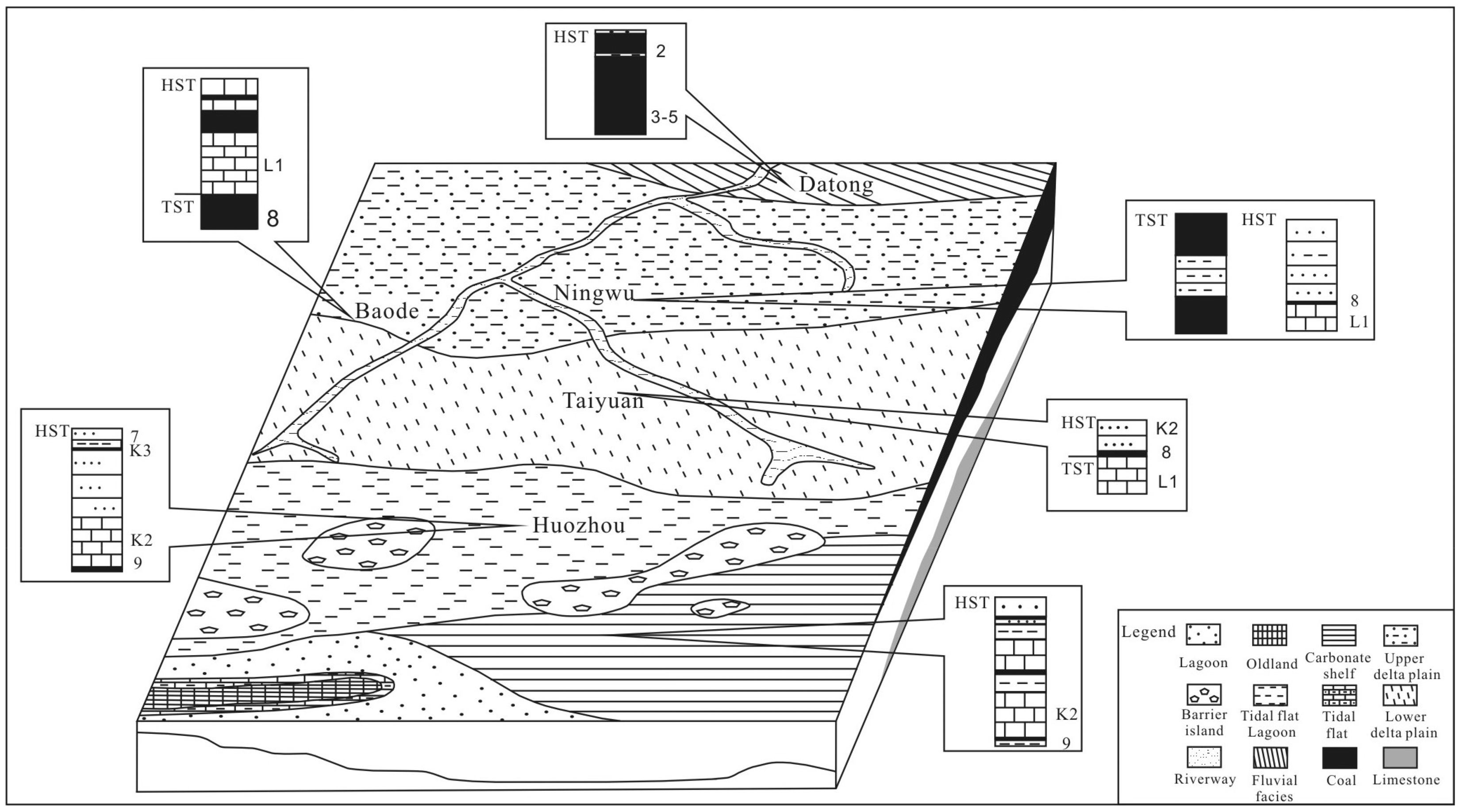
Shanxi Province is located in the west of North China plate; the main Carboniferous-Permian coal-bearing strata are the Benxi Formation, Taiyuan Formation and Shanxi Formation.
According to the strata development status, lithology combination and coal-bearing property, the stratum in Shanxi province is divided into three districts: the Datong – Huairen district at the northern edge, the Ningw – Linfen district in the center, and the Gengqu – Xiaxian district at the southern edge (Zhang, 1985).
Formed in transitional environment, the thickness of the Taiyuan Formation stratum changed greatly, with a range of 35–115 m. In the Datong – Huairen area, the thickness of the strata ranges from 75 to 115 m up to 115 m, and then decreases from north to south without marine limestone development. In the area of Ningwu – Linfen and Gengqu – Xiaxian, the thickness of stratum is less from southeast to southwest and north to south, which ranges from 35 to 105 m (Figure 1). The stratum thickness in the Hedong coalfield was lesser than other coalfields.
The map of strata thickness contours (boundary division from Zhang, 1985).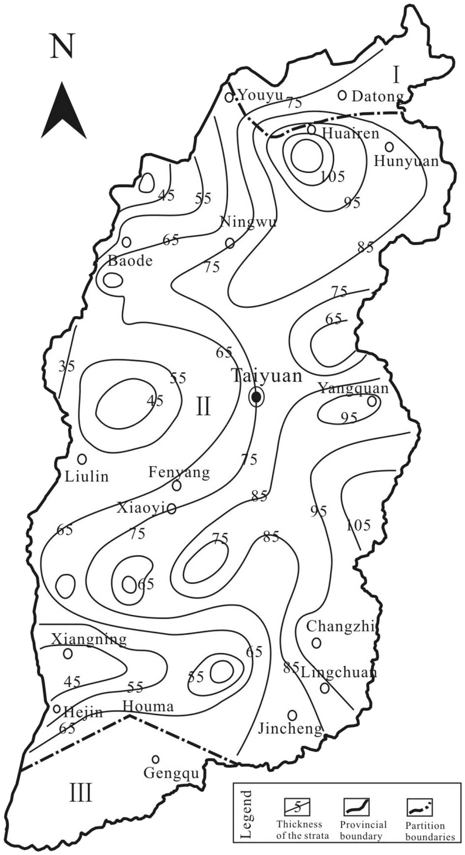
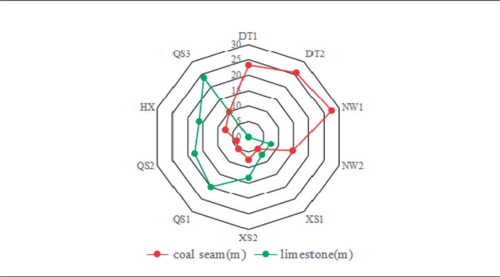
The thick coal seam is mostly formed in the periods of the maximum sea (lake) sedimentary, so that the thick coal seam location can be identified as the position of the maximum flooding. Based on the situation of sedimentary facies and strata development, the thick coal seams mostly concentrated in the Datong–Huairen–Ningwu area, with a range of 0–24 m thickness. The overall thickness changes of the coal seams are thin in the south and east but thick in the west and north, associated with the changes caused by factors such as sedimentary environment, climate changes, marine transgression and regression (Lv and Chen, 2014; Oplustil et al., 2013; Shao et al., 2014; Xu et al., 2015).
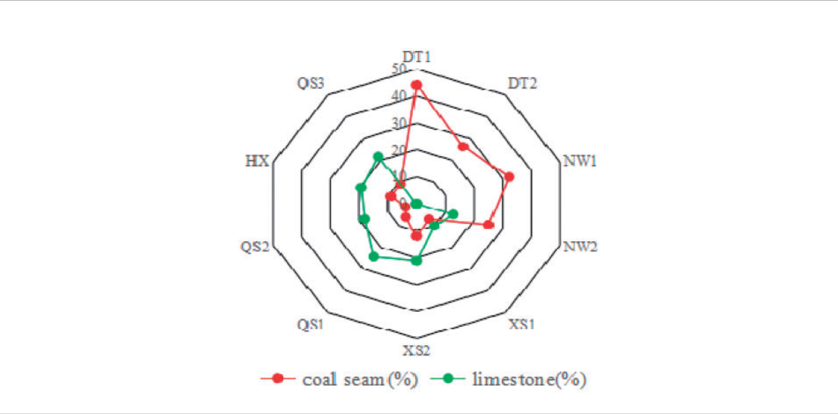
The coal-bearing sedimentary center of the Taiyuan Formation located in the north of Shanxi province has a high coal-bearing coefficient of 22–41% in the Datong area, up to 24 m thickness; only 2–6 m thickness of coal seam develops in the central and southern of Shanxi province, with 4.5–35% coal-bearing coefficient in the Ningwu–Linfen area, 3–4% coal-bearing coefficient in the Gengqu-Xiaxian area (Figure 2).
The map of coal seam thickness (boundary division from Zhang, 1985).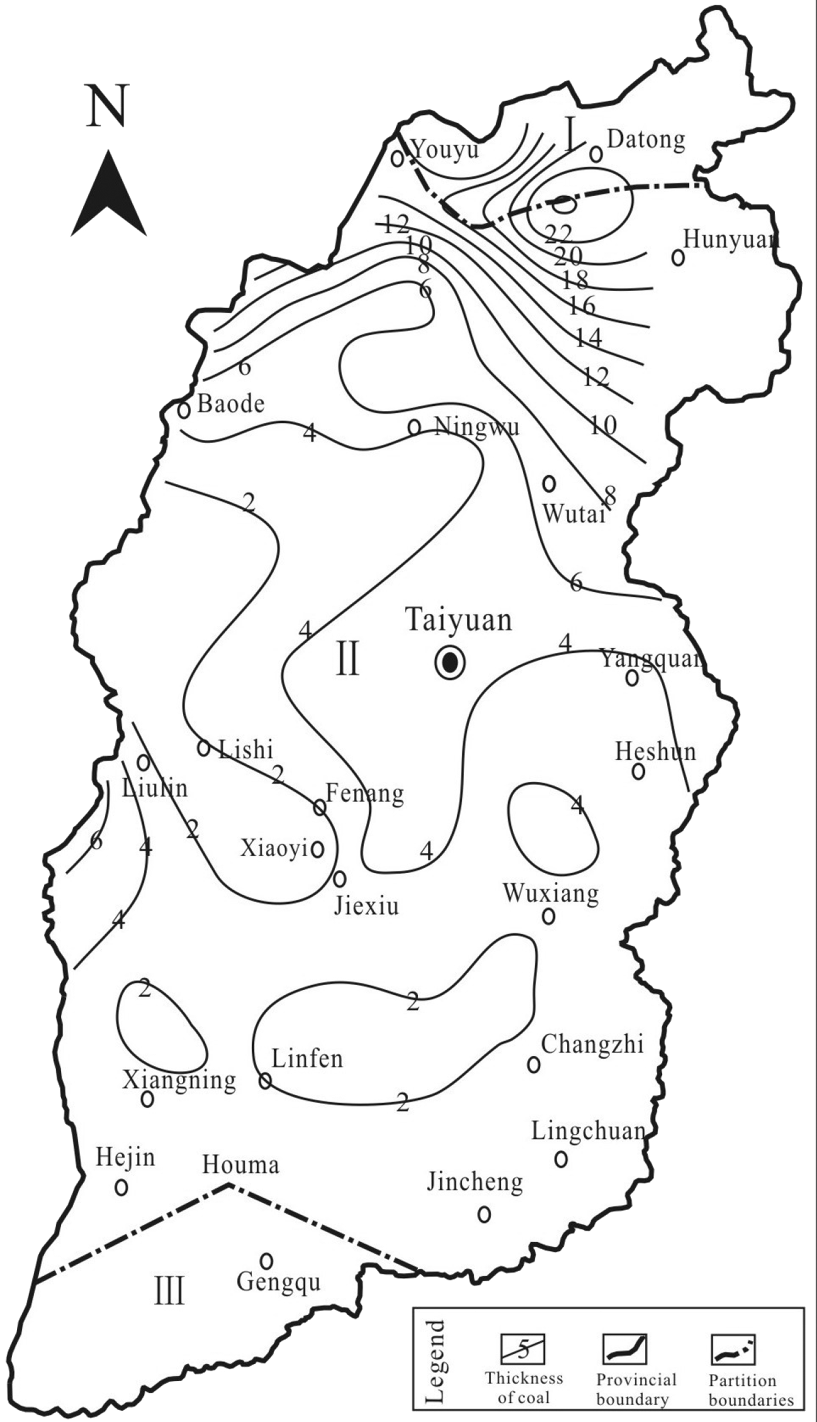
Lithology characteristics of the Taiyuan Formation and the extension of limestone layers
Sedimentary environments and the paleontology research of Wujiayu-Shangou limestone and its corresponding layers show that the environment of the late Paleozoic in Shanxi Province was a wide epicontinental sea basin with shallow slope, marine transgression and frequent regression; hence, its limestone is regarded as isochronous sedimentary (Li et al., 2006; Lu et al., 2012; Shao et al., 2014; Wang and Pfefferkorn, 2013).
As a set of paralic coal-bearing series, the Taiyuan Formation is divided into three members from the top to bottom, the Jinci section, the Xishan section and the Shangou section. The Jinci section was continued sediment on the Benxi Formation, Xishan section’s transgression directions were transferred from southeast to north, and the Shangou section only had development southeast of Shanxi province. This paper only discusses the conditions of limestone and coal thickness in the Xishan section and Shangou section.
Xishan section’s lithology were composed of white sandstone, dark sandy mudstone, the layers of limestone and mudstone increasing from north to south (except the Datong-Huairen area). Additionally, there were one to three layers of marine mudstone and muddy limestone in the line of the Suoxian – Pianguan – Hunyuan – Ningwu area, four to five layers of limestone and muddy limestone development in the south of Taiyuan – Yangquan area, and six layers limestone development in the southeast of Shanxi province.
Shangou section’s lithology was composed of dark fine sandstone and sandy mudstone, with one to two layers of sandstone and marlite mainly in the Lingchuan area. The lithofacies transformed to silicalite in the north of Changzhi, such as Zuoquan, Wuxiang, and Xianggeng, to silicalite and marlite in Gaoping, such as Lingchuan, Jincheng, Yangcheng and Qinshui.
Overall, the average thickness of Miaogou limestone (L1) is 1–3 m, up to 6 m. The thickness of Maoergou limestone (L2, L3) gradually increases from south to north, with 1.6–8.0 m thickness in the Xishan area, develops limestone in the south of the Taiyuan area but marl or marine mudstone in the north. The average thickness of Xiedao limestone (L4) in the northern area is 0–2.5 m, 2.5–5 m in the central and southern areas, and up to 10 m in the areas of Liulin and Xiangming. Dongdayao limestone (L5) is generally 0–2.5 m thick, with black sandy mudstone and biological chip micritic-microcrystalline siderite rock. The average thickness of Shangou limestone (L6) is 0–2.5 m, up to 5.6 m thickness in the Yangcheng area. On the large span from north to south and a variety of sedimentary environments, different lithologic characteristics are observed in different areas.
Limestone represents the sea flood stage in each coal-bearing cycle, and has the isochronous in Shanxi province. On behalf of the maximum flooding in the sequence, limestone can be used as the boundary for transgressive systems tract (TST) and highstand system tract (HST). The content of limestone represents the range of transgression. The limestone distribution is mainly concentrated in the south of Shanxi province, even reaching 50% in individual regions, but rarely distributed in the northern area. The content of limestone in Datong – Huairen district is lower than 5%, 5–45% in the Ningwu – Linfen district, hardly exists in the Gengqu – Xiaxian district. The layers and thickness of limestone increased regularly from northwest to southeast, while the content of limestone reduced from south to north and west to east (Figure 3). The layers, thickness and content variation of the limestone in the Xishan section and Shangou section indicated that seawater came from the southeast, and the Miaogou-Maoergou limestone were formed in the largest transgression period.
The map of content of limestone (boundary division from Zhang, 1985).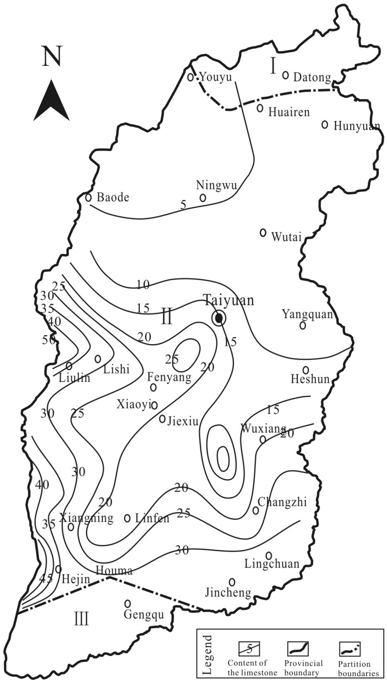
When compared with the layers, it can be found that the content and thickness of the limestone and coal seam were in a negative relationship for certain combinations, such as thick coal seam with thin limestone, thin coal seam with thick limestone, but in special situations such as thick coal seam development in the layers of thick limestone. When the content of limestone is less than 5%, its coal seam thickness increases up to 20 m. For a content of 5–45%, the coal seam thickness changes between 0 and 6 m. For a content greater than 45%, there was no coal seam development; 40–50% content of limestone in Hedong mining area with 4–6 m thickness of the coal seam.
Relation between limestone layers and coal seam thickness in Taiyuan Formation
The initial flooding surfaces and the maximum flooding surfaces in four-order sequence are the interface to divide the lowstand system tract (LST), TST and HST. From the sedimentary environment, the characteristics and combination of rocks, i.e. the regional distribution of coal seam and limestone, represent the maximum flooding surface in its sedimentary strata sequence (Li et al., 2006; Lv and Chen, 2014; Shao et al., 2014). Shao et al. and Li et al. considered the coal seams are more developed in the process of transgression, instead of forming in the process of regression.
The sedimentary environment, palaeontological, terrigenous clastic composition and trace elements usually have obvious changes in the sequence interface, such as the Jinci sandstone used as the valley erosion surface and the 15th coal seam in the Lingchan area used as the conversion surface of the transgression direction.
In the Taiyuan Formation, a wide range area of Shanxi province was obviously affected by the transgressive event deposits, and the source direction mainly came from the old-land of Inner Mongolia in the northwest. Although most thick coal seams develop in TST, some are also found in HST. For example, the ninth coal seam of the Datong area is formed in TST, but the thickest coal seam of the fifth coal seam in this area is formed in HST because of the conversion of the transgressive direction.
Comparing the developed situation of the limestone and coal seam in different mining areas, it was found that there were layers of coal seam but a smaller amount of limestone was found in the Datong mining area. There are layers of limestone south of the Ningwu mining area but are not visible in the north, and the thickness of the ninth coal seam was thick from north to south. The eighth and ninth coal seams in the Xishan mining area were in the way of forking, merge and forking again and on the trend of thick in north and thin in the south. The Dongdayao (L6) only exists south of the Xishan area. The range of the strata is large in the Qinshui mining area and the development layers of the limestone, such as Maoergou limestone, Miaogou limestone, Dongdayao limestone and Fucheng limestone. The thin coal seam, as the ninth coal seam in the Huoxi mining area, was associated with the thickness of Maoergou limestone (Figures 4 and 5).
The thickness of the coal seam and limestone. The content of the coal seam and limestone.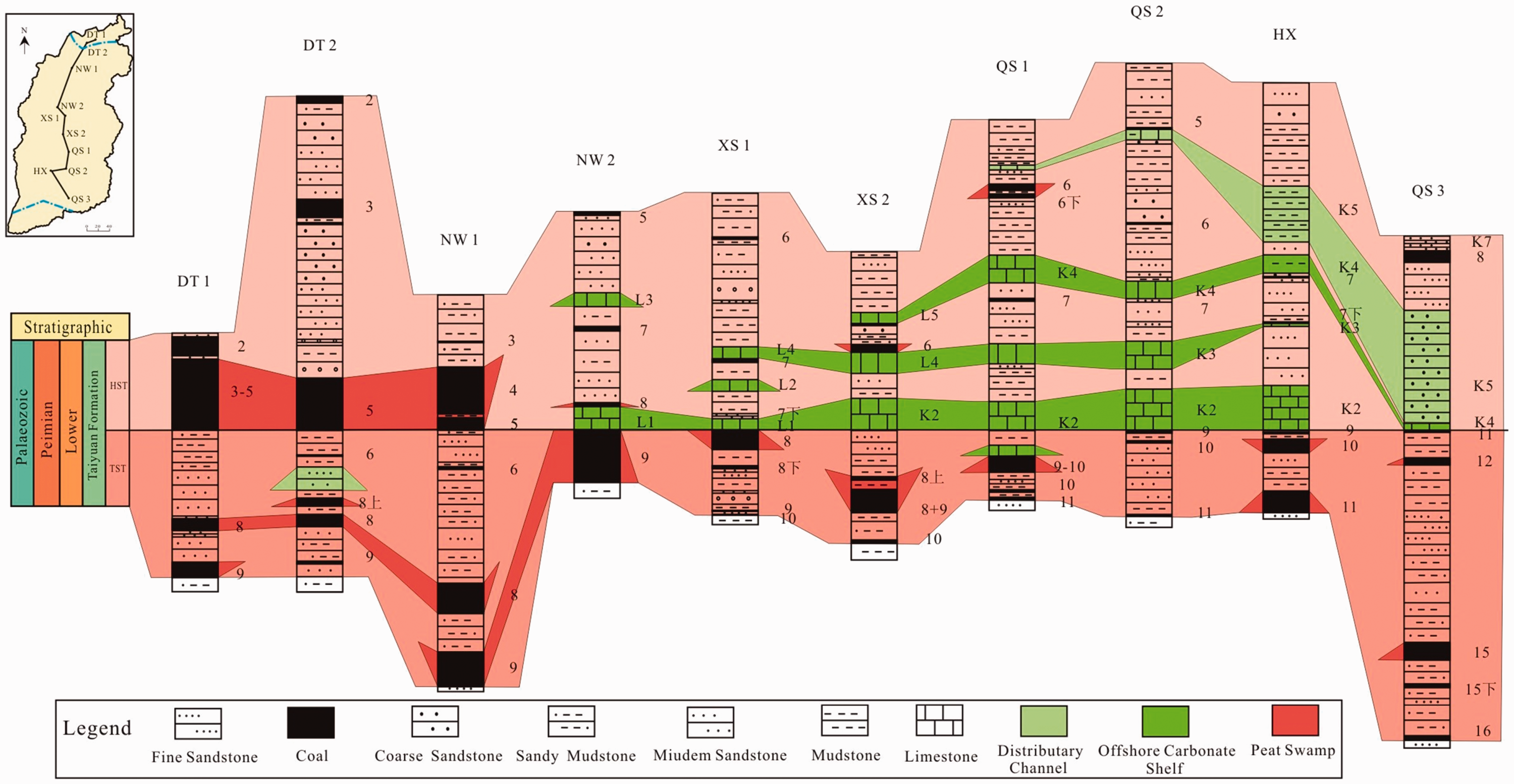
Correlation of the strata in the Taiyuan formation.
The HST–TST sequence interface of the Taiyuan Formation in the Datong–Ningwu (northern part) area is the thickest layer of the coal seam. The types of the lithology, thickness and layers of the limestone increased on this interface from north to south but decrease in the coal-bearing coefficient. For example, the thick coal seams developed in the Datong–Ningwu area are thick in the north but thinner in the south area. The HST–TST sequence interface of the Taiyuan Formation in the Ningwu (southern part) – Qinshui area has the thickest layer of limestone.
Types of the coal seam and limestone in Taiyuan formation.
In this paper, we considered the bottom boundary of the early Permian in the perspective of the lithology characteristics, sedimentary phase, and the variation of the limestone and coal seam thickness. The boundary in the Datong area, dominated by fluvial facies, was lined under the ninth coal seam, with a 24 m coal seam thickness, and no limestone existed. The boundary in the Ningwu – Xishan (north) area, dominated by delta sedimentary, was also lined under the ninth coal seam, but the thickness of the coal seam was less than the Datong area. One to two layers of limestone exist. The boundary in the Xishan (south) area, affected by height changes of the plate from north to south, was lined under the 10th coal seam. Influenced by the changes of the transgressive direction, the boundary in the Huoxi – Qinshui area was lined under the 11th coal seam. The boundary southeast of Shanxi province, dominated by carbonate shelf, was lined under the 16th coal seam, with four to six layers of limestone.
Conclusions
Based on the analysis of the coal seam and limestone of Taiyuan Formation in Shanxi province, we conclude with the following statements.
The whole thickness of limestone in Shanxi province is increased from northwest to southeast; the content reduced from south to north and west to east, the thickest coal seam appeared in the south of Hedong mining area. The overall changes of coal seam thickness were: thick in the north and west and thin in the south and east, from Datong mining area as the center of radiation to the south. Negative correlation between the coal seam and limestone of Taiyuan Formation in Shanxi province, in the characteristics of thick coal seam with thin limestone and thin coal seam with thick limestone. Less than 5% of limestone, the coal seam thickness up to 20 m; 5%–45% of limestone, the coal seam thickness changes between 0 and 6 m; greater than 45% of limestone, no coal-bear strata exist, but in the Hedong mining area, 50% of limestone with 6 m thickness of the coal seam. There are different coal-forming situations for the HST and TSTs. The layers and thickness of limestone increased from north to south in HST, which decreased in coal-bearing property, and the thick coal seam only occupied in Datong and Hedong. The thickness of the coal seam decreased from north to south in TST, and the coal-bearing property of TST better than in HST. The factors influencing the negative correlation of the coal seam and limestone should be combined with sedimentary environment, transgressive direction and provenance. Due to the tectonic movement and the transgressive, regressive and sedimentary environments, the bottom boundary of the Permian system is lined in the Datong–NingWu – Xishan (north) area, the Xishan (south) area, the Huozhou (west) – Qinshui basin, Qinshui basin (SE), respectively, under the ninth, 10th, 11th, and 16th coal seams.
Footnotes
Declaration of conflicting interests
The author(s) declared no potential conflicts of interest with respect to the research, authorship, and/or publication of this article.
Funding
The author(s) disclosed receipt of the following financial support for the research, authorship, and/or publication of this article: This study was financially supported by the National Science Fundamental of China Project (No. 41430640 and No. 41672153).