
Abstract
This article analyzes the morphology and functionality of the Jewish quarter of Zaragoza at the end of the fifteenth century, shortly before the expulsion of the Jews in 1492, from a multidisciplinary perspective. It deals with the specific nature and understanding of one of the most important Jewish neighborhoods in Sepharad on the internal levels of Hebrew law and the confessional community, where urbanism is traced out from the privacy of the home and not from the public space and where the neighborhood is linked to the synagogues. Over two thousand documents from the 1492 to 1500 period, from the Archive of the Crown of Aragon, notarial protocols, municipal sources, and inquisitorial trials, have been consulted. A method of vertical cartographic coordination based on geographic information systems is applied as a way of geo-referencing the oldest surviving plans to reconstruct the physical and experiential space of the city in the Late Middle Ages.
Approach, Sources, and Methodology 1
Among other consequences, the expulsion of the Jews in 1492 led to the morphological integration of the Jewish quarters into the Christian cities in which they were located. This involved changes in the ownership of both public and private buildings and the demolition of elements of separation that had been in use since the early fifteenth century.
The documents generated in the period between 1492 and 1500, from the notarial protocols and municipal sources, as well as from the Royal Chancellery, regarding the extinction of the aljama (Jewish community), offer a detailed overview of this habitat.
The design of the method incorporates the geographic information systems (GIS) as a tool for studying historical cartography, an approach with many recent references that ensure its suitability. 2 There are already specific studies of the city of Zaragoza in the Roman and Islamic periods in which the analysis of the historical cartography with this tool shows its applicability for reconstructing urban areas, and where the transformations through time have led to the disappearance of the original topographic traits. 3
As a novel aspect, this study applies a method of geo-referenced cartographic coordination, considering the various surviving plans of the city. The plans used are of the city in 1712 and its neighborhoods from 1723, 4 together with the plan of the Historic Centre (General Parcelario del Casco Histórico) by Dionisio Casañal, available on the City Council’s historical archive. 5 The plan from 1712 is the oldest that has been preserved and the plan made by Dionisio Casañal in 1911 is the one that represents the plots in more detail (Figure 1).
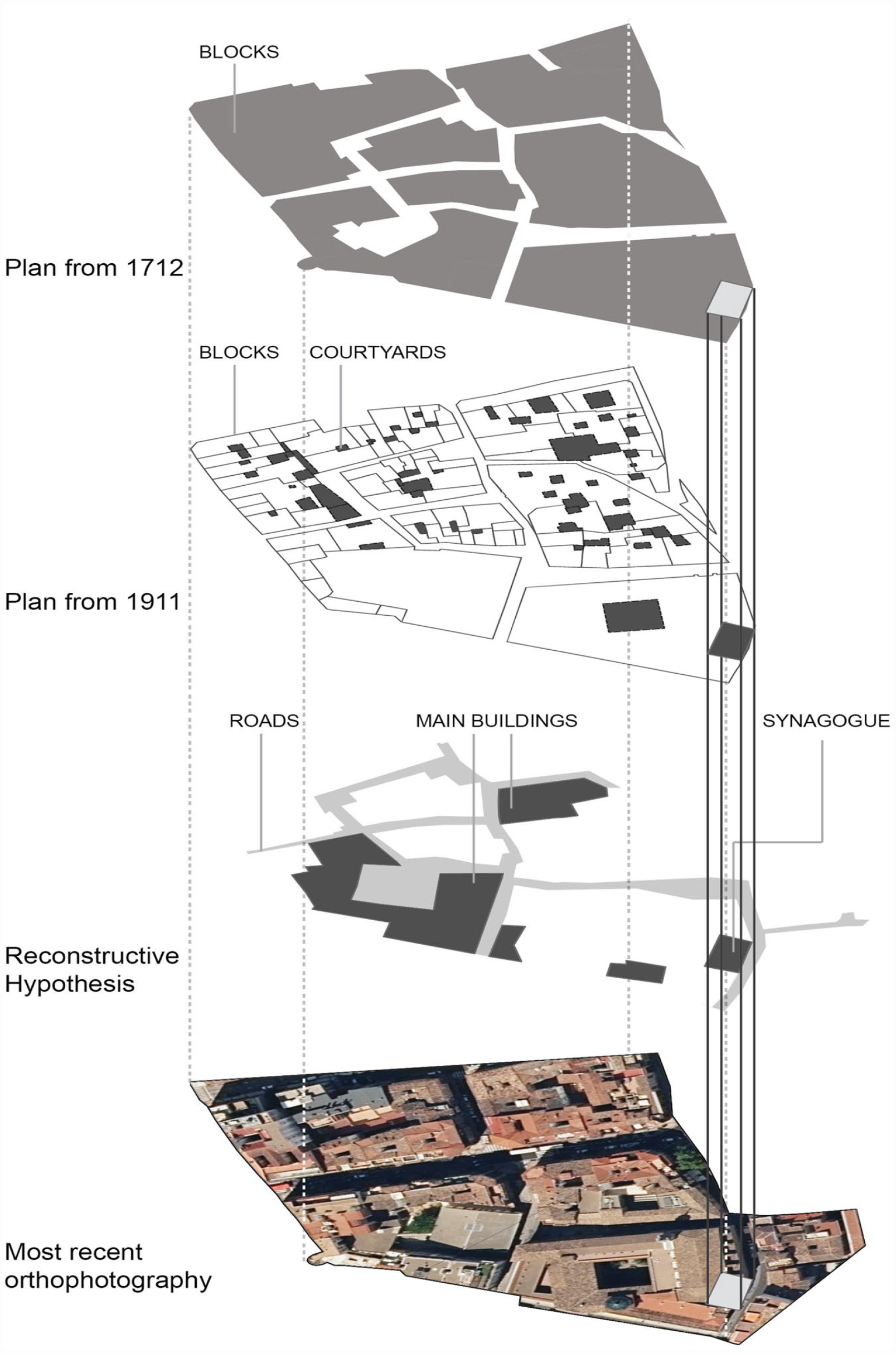
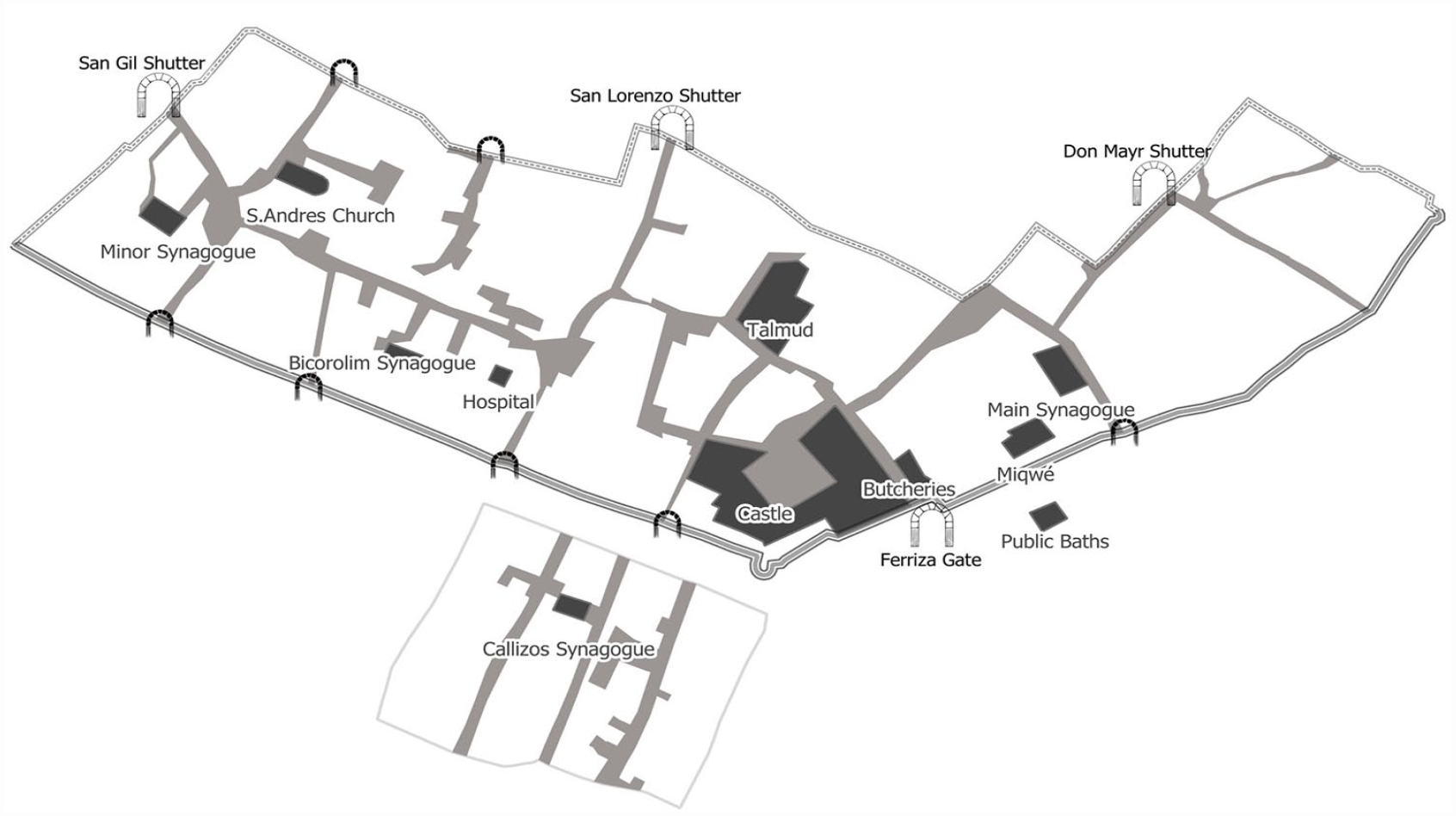
Applied conceptual model.
To apply vertical coordination, prior geo-referencing and vectorization of the plans was carried out in the QGIS visualization environment, in a UTM ETRS89 zone 30 north, projected coordinate system. Unlike the static vision of classic cartographies, this approach evaluates the degree of morphological precision that is extracted from the analysis of the texts, as well as from their systematization and cartographic depictions. 6 This methodology provides information which is valuable for locating the elements mentioned in the historical sources, as well as for identifying their spatial interrelationships. This allows an in-depth characterization of a singular space in the city in the Late Middle Ages. Likewise, specific patterns of the functional hierarchy of the Jewish quarter are identified, and these can be extrapolated to other points of the geography of Sepharad.
Historical Context: The City and Its Neighborhoods
Zaragoza is a metropolis with a population of approximately 25,000 inhabitants at the end of the Middle Ages, that is, about a tenth of the population of the kingdom, including a remarkable Jewish and Mudejar communities. 7 In addition, it has a privileged status with respect to the rest of the cities, 8 since it has the main institutions of the Administration, and turns into a neuralgic center of the mercantile and communications flow of the northeast of the Iberian Peninsula, where the main political and mercantile elites of Aragon reside. 9
Since the mid-fourteenth century (1356-1369), the space available for urbanization was doubled compared to the area of the old Cesaraugusta, with the construction of a second brick wall. 10 The Christian population is distributed in fifteen parishes, in a process initiated in the middle of the thirteenth century (Figure 2). They are classified as Majors (Santa María la Mayor, San Salvador, San Pablo, Santa María Magdalena, San Felipe, San Gil, Santa Cruz, San Juan del Puente, and San Jaime) and Minors (San Pedro, San Andrés, San Lorenzo, San Nicolás, San Juan el Viejo, and San Miguel de los Navarros). 11
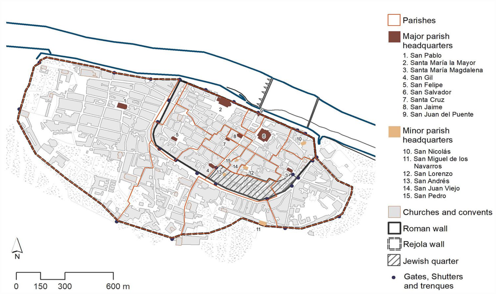
Christian parishes, Jewish and Moorish quarters at the end of the fifteenth century.
The hearth tax of 1495 enables the structuring of the space to be appreciated from a sectorial viewpoint. San Pablo was the most populous parish, with 1,229 hearths and, together with Santa María la Mayor, contained 45 percent of the dwellings. These were followed in decreasing order by La Magdalena, San Miguel, San Gil, San Felipe, and San Salvador, while the rest did not exceed 14.4 percent, with some being insignificant, like San Andrés (0.6%), part of whose territory belonged to the Jewry. 12 The Christian elite, preponderant in the first half of the fifteenth century, had a well-defined professional profile in which notaries (27%), merchants (26.6%), and jurists (12.4%) stood out, and where there were hardly any doctors or spice merchants (1.4%). 13 However, in the second half of the century, a select circle of Jewish converts with common economic and political interests, who aspired to enter the mercantile oligarchy and the administration, would partially modify the composition of those elites.
The Moorish quarter is not built from scratch but is based on a preexistent area. After the conquest of the city in 1118, the Muslim population moved their residence to an old Islamic suburb built in the tenth century, southwest of the Medina. The neighborhood is delimited by a brick wall, forming an isolated unit, emulating the urban structure of a Muslim city. A mosque is erected in Azoque Street, with a small square in front of it, as the hierarchical core of the space, and political and religious center. It borders commercial, artisan—concentrated in Cedaceros, Azoque, Fustería, Ferrería, Zapatería, and Alfóndiga—and residential areas. However, as in the case of the Jewish quarter, its inhabitants must adapt to an inherited urbanism with a different functionality. The reorganization and redefinition of the space has been consolidated since the fourteenth century. 14
Moreover, after the persecutions of 1391, the Jewish community of Zaragoza became the most important in the Crown of Aragon. In the census carried out in 1406 in the Courts of Maella, 347 fiscal households were registered, without taking the free families (around twenty houses) into account. In other words, there was a population of around 1,400-1,550, some 11 percent of the city’s total. 15
A report issued in 1415, on the application of the royal pragmatics and the bull of Benedict XIII at the end of the Dispute of Tortosa, reveals that, in addition to closing all the synagogues except one, the aim was to move the inhabitants intramuros. However, after carrying out an inspection in situ, the merino, the royal official responsible for carrying this out, considered it impossible to relocate the occupants of the three hundred houses in Barrionuevo. 16
Despite the conversions in the first decades of the fifteenth century, which affected one in every four Jews, 17 the Jewish population of Zaragoza increased due to immigration from other closed Jewish quarters and natural growth to the point that in 1492 there were 460 households. This is stated in the receipt for the seals placed on the doors of the homes issued by the painters Cristóbal de Cazorla and Juan de Quintanilla before carrying out inventories. 18
The syntax of the Jewish quarter, like the city in which it was located, was not the result of a mere grouping of people, but rather arose from their social structure and reflected a way of understanding the world. 19 The study of this space, which is never neutral, involves interpreting the limits of society and its mentality. 20 In short, the locus is a projected image, where everything depicted is defined, structured, and organized. 21 The human body represented a microcosm for Jewish culture, whose symbolic system was also translated into urbanism, where society and space confer reciprocal meaning on each other. 22 Not surprisingly, its neighborhoods territorialized human ecology and anthropology. 23
The Jewry is like the Islamic city as a community of believers, 24 whose functionality has an intense liturgical charge and generates specific spaces. For this we use the heuristic concept of “Jewishness,” that is, the way in which its inhabitants lived and experienced the space, where the religious component permeated everything, generating private or residential spaces and other public and ritual ones. 25 Moreover, intangibles generate enculturated spaces that limit or facilitate everyday activities subject to a specific religious rule. Hence, for example, the importance of the ’eruv, 26 or a symbolic breaking of the Sabbath boundary, which allows the transport of certain objects and the performance of certain tasks on the Holy Day that would be unfeasible, including attendance at synagogue, if the boundaries of the wall were breached. 27
This area was divided into two neighborhoods with a different urban and sociological parameter: the Old Jewish quarter, inside the walls, and the New Jewish quarter, outside the walls. Whether or not the Jewish quarter is located within the city walls is relevant. 28 The Misnah in Treatise ’Arakhin, in dealing with walled cities, confers special legal treatment. 29
The first was in the south-eastern part of the imperial Roman lower city, and housed the most prestigious community institutions, while the second was in the parish of San Miguel, where the families, mostly of leather workers and cobblers, lived in rented accommodation.
Old Jewish Quarter 30
The plan presents a heterotropic morphology, far from the Roman logic on which it was based—whose occupants transformed it over successive generations 31 —where streets and squares were the primary element. Its layout, within the spatial limitations imposed by political power, 32 was neither random nor anarchic, 33 since between the rational and irrational is the non-rational. 34 The hierarchy was not morphological but more functional, 35 so that the function was defined by the presence of an element, and not by its position, which was mutable and nuanced it. 36
The Islamic Saraqusta—the Jews continue to live autonomously in the same space as during the Roman period—modified the layout of Augustus by means of the private appropriation of its land and the absence of control mechanisms by the authorities over construction unless they infringed on private rights and ways of life. Except for the Cardo and the Decumanus, the urban layout was fragmented, with the street losing priority as the primary space and the secondary streets becoming progressively privatized. 37
The Jewish quarter behaves like a micro-universe, like cells that do not merge organically and function on two axes: religion and civil power. Given that they are assigned a priori the place to inhabit and that their settlement does not take place ex novo, there is an almost symbiotic superposition of one system on the other. 38 Wherever the general plan is rational Greco-Latin, as in our case, or the Eastern plan of almost vegetable growth, its habitants will adopt it without any problem. 39
Limits and Gates
It was surrounded on the southeast by the stone and mortar wall of ancient Cesaraugusta. 40 It stretched from the oil mill, near the San Gil cemetery (exit from Calle Jaime I to Coso) to the Puerta de Valencia, marked by twenty-six circular towers (Figure 3). 41 The first eleven towers, starting from the Puerta Cinegia, 42 belonged to the city, 43 and the wall that adjoined the Jewish quarter belonged to the king. Beyond the entrance of Puerta Cinegia, the towers—from the first to the fifth, facing the Jewish quarter—belonged to the king, but the city owned the internal sections of the wall and the remaining towers up to the Puerta de Valencia, 44 currently Plaza de la Magdalena (Figure 4). 45
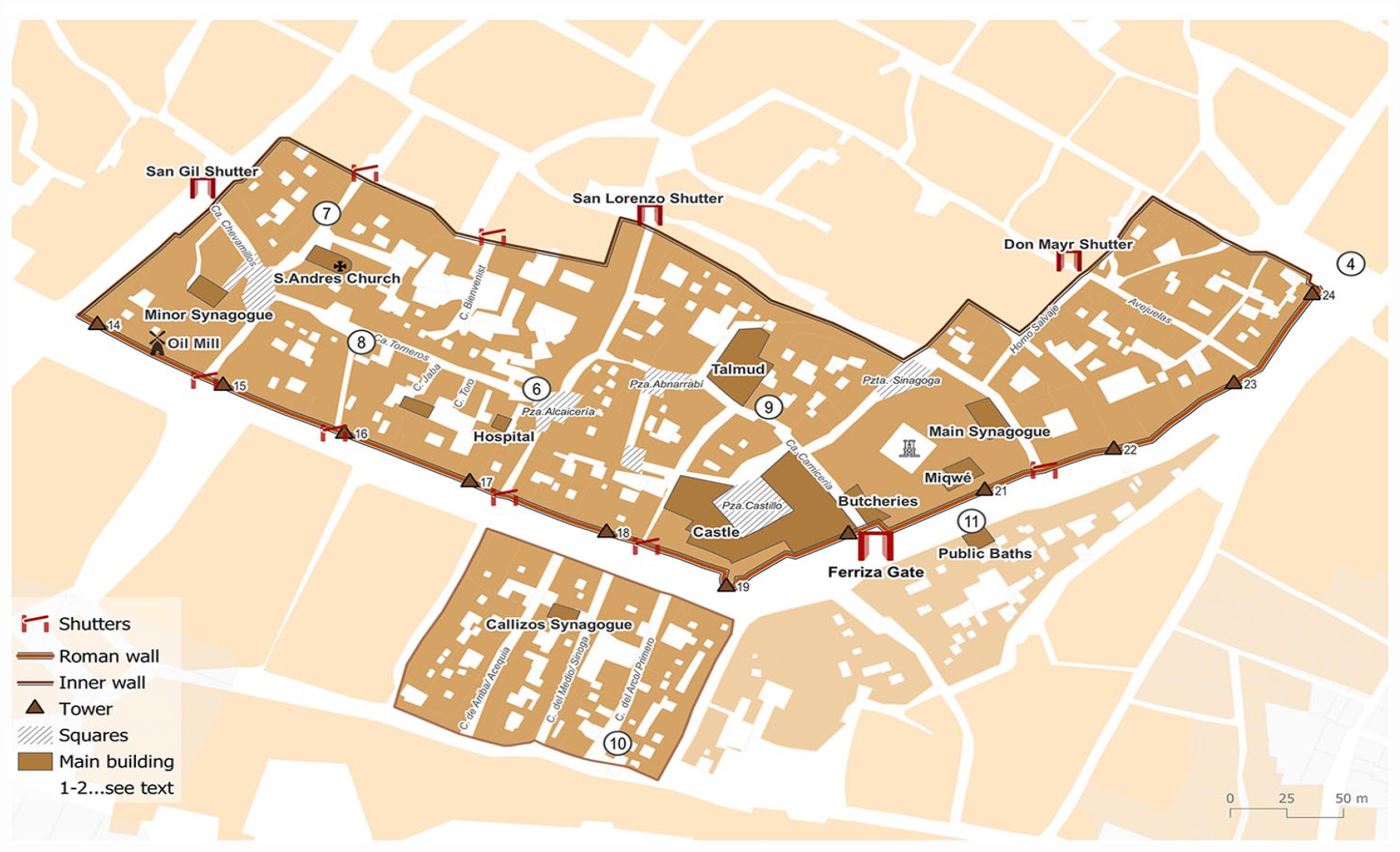
Reconstruction of the Jewish quarter in the fifteenth century through the vertical coordination technique and geographic information systems (GIS).
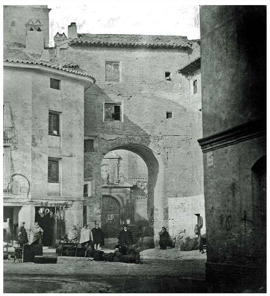
Puerta de Valencia in 1853.
The Roman wall: Puerta Ferriza
It was linked to the outside through three gates that were closed at night or in times of danger and uncertainty: the main one, the Portal de la Judería or Puerta Ferriza, and two secondary posterns—partly blocked from the second half of the fourteenth century—that of San Andrés and that of the oil mill. This does not preclude the existence of passageways or stairs built into the wall, as was the case in the homes of Bella Valencia or Rabbi Salamón Zunana, near the Los Torneros synagogue. 46
The old Rabinad postern, existing since at least 1228, was closed in 1357, due to the War of the Dos Pedros (Peter I, of Castile, and Peter IV, of Aragón). After the conflict, it was reopened around 1368, adopting the name of Puerta Ferriza. It was the main access to the neighborhood, since the sources refer to it as the entrance of the Jewish quarter. 47 It was located at the confluence of Santo Dominguito de Val with Coso, in the line the wall followed between the tower of the Carnicería and the Castle, in front of the Jewish Baths and the Piedras del Coso. Its surroundings were heterogeneous, given the disorderly accumulation of dwellings in a reduced space. 48 The narrow space between roofs turned these streets into something closer to dark passageways.
The descriptions of the juries show that this gate was small, hence its description as a postern, since someone on horseback could barely pass through it. 49 In addition, it did not allow decent access from the Barrionuevo to Coso, with the aggravating circumstance that it conserved the Hebrew inscriptions, and it also meant that when a procession from the church of San Miguel, presided over by Christ, came to collect a deceased person, its members had to bow down, which was considered an affront to the Christian religion. 50
Inner wall
An internal delimitation in brick or rammed earth (in some sections the rear of the buildings) separated the Jewish quarter from the rest of the city, as corroborated by the fact that they made three entrances in it, these being Postigo Don Mayr, Puerta de San Lorenzo, and Puerta de San Gil, in addition to the fact that the documentation distinguishes “el muro mayor de piedra” (the largest stone wall), which leads us to think of a smaller one. In the second half of the fifteenth century, a “muro nuevo” or “muro de la joderia” is referred to as running through the parish of San Gil. 51 Some documents refer to houses in the same calle San Gil, 52 near the alley of Chevamillos. 53 This was the result of the segregationist measures.
It started from the San Gil fossar—current exit from Don Jaime to Coso—continuing along the right side of the carrera de San Gil—even numbers of Don Jaime, entering through Coso—turning at right angles to the right before arriving at Calle San Jorge, and continuing through a maze of narrow streets to Plaza de la Magdalena. 54
Postigo Don Mayr
This was located at the intersection of Calle del Postigo de la Judería—Calle San Lorenzo—with the alley of the Horno del Salvaje—Calle de los Estudios—running south toward the Mayor Synagogue. It was possibly the oldest in the Jewish quarter, since the sources refer to this enclave as “el postigo viello de la juderia” (the old shutter of the Jewish quarter), in memory of Don Mayr Alazar, who died in 1383. 55
The most prestigious point of reference now is the doctor, Bonjua del Portal, who owned real estate—part adjoining the stone wall, so this would be in the eastern part—made up of two house doorways (2,000 sueldos 56 ), a shop or botiga, corral and cellar (1,800 sueldos), 57 which were entered through the “calizo de maestre Bonjua.” 58 Noha Chinillo and his son Vidal had two doorways with two pens (3,250 sueldos) 59 ; Simuel Perelló, three houses close to the public alleyway (2,600 sueldos 60 ), similar to those of Saraya Benosillo (2,666 sueldos). 61 Nearby, there were two houses belonging to Abraham Abencanyas (2,750 sueldos) adjoining the wall and two alleys. 62
The sources do not refer to a single alley, 63 but allude to the confluence of two public streets, one of them belonging to the parish of San Lorenzo, 64 as it was in the northern part of the neighborhood. Indeed, calle El Postigo ran in front of the dwellings of Mossé Alazar, an eminent doctor, and Salamón Alazar (4,000 sueldos). 65
In the neighborhood, there were the houses belonging to Jucé Abendavit, Simuel Baco, Abadía Benosillo, Abraham Nanías, Margallón Alcovardero, Simuel Amiba, Vidal Falleba, and Simuel Perelló. 66 These included Bienvenist Profet, Bonafós Abnarrabí, Mossé Abder, Vidal Abnarrabí, Açach Salamón, Haym Axivili (1,000 sueldos), Jehudá Bendavid, Mossé Daça, and Vidal Falleba. 67 The existence of gardens and corrals, rare in other, much more densely populated, urban areas, as well as small shops, such as that owned by Zacarías Benosillo, is significant. 68
Puerta de San Lorenzo
This allowed movement between the walled Jewish quarter and the homonymous parish. Documented since 1368, it was at the intersection of Calle San Jorge and Calle Pedro Joaquín Soler. In the fourteenth century, it was a residential area preferred by the Cavallería and Alazar families, vassals of the Order of Saint John of the Hospital. 69
Puerta de San Gil
This was in front of the church of San Gil, at the end of an alley that led to the prison, which was located near Puerta Cinegia, until 1440 when it was moved to the Puerta de Toledo. The Chivamillos alley, which goes into the heart of the Jewish quarter, starts from there, 70 following a west–east axis.
Road Network, Hierarchy, and Urbanism
The main public streets, called carreras, served as access to the secondary ones. These secondary streets were narrow and broken, with blind alleys and labyrinthine ramifications, as a result of the juxtaposition of irregular blocks (Figure 5).
Nodes and trajectories defined in the reconstructive hypothesis as the main articulating axes of the Old Jewish Quarter in connection with religious and civic centers.
Carreras
While the Maliki school rejects any rule that is not in the Koran and limits itself to the satisfaction of basic needs of movement and access, 71 in the rabbinic tradition, a minimum distance of four cubits is established to ensure that the easement of light, increasing to fifty cubits when they emit noxious odors or transmit impurity. 72 Thus, carreras were the only elements of the urban space with a certain regularity and breadth—rabbinical law established a minimum distance to guarantee that the easement of lights and views was not violated. 73 These served for the traffic of merchandise and people, and linked the public institutions, which condensed civil and religious life, and the exterior gates. 74
Two of the main axes ran north–south. The first was by the “carrera que va drecha al postigo Domayr” (main public street leading directly to Postigo Don Mayr) from the Mayor Synagogue, as can be seen on the boundaries of the houses of Simuel Abenrabí and Mossé Alazar, which would become the property of the church of Santa María la Mayor. 75 To make it more viable, in 1496, the town hall opened a new carrera that connected with Coso. 76
The second, near the brotherhood of the Talmud, generated an axis parallel to the previous one, formed by a carrera that ran along one of its sides, and that connected with a second artery that ended in the Plaza del Castillo. 77
Although it did not acquire the category of a carrera, the Chevamillos alley 78 or “calliço de la Puerta de San Gil a la Judería,” 79 coincided for a large part of its length with Calle de la Verónica. It connected the Puerta de San Gil with the Minor synagogue, Calle de los Torneros, where the Biqqur Holim Synagogue was located, and the Alcaicería neighborhood, a bazaar where trinkets, silks, and luxury items were sold, in the Plazuela de la Verónica, and the end of Calle de San Pedro Nolasco, from where the Puerta de San Lorenzo was reached (Figure 6). 80
Plazuela de la Verónica, where la Alcaicería was located.
Squares
In the rabbinic conception, the street is not a space for relationships, nor is the square conceived as an agora. Thus, not surprisingly, the Main Synagogue, an axial building, only had a small square next to it. 81
One of the exceptions is the Plaza del Castillo, known in the documents as the “Plaça de la Juderia,” so it seems that it was the largest one. 82 Around it was the building, of Roman origins, which, due to its monumental nature, did not undergo structural modifications, and which was used as a prison and the community’s archive. 83 It also housed highly valued private homes with the Hospital on one of its sides and close to the miqwé. 84
The Plaza Abnarrabí, flanked by two public streets, 85 was a prestigious area. It was not very large, since it was defined as a placeta (little square). 86 The members of the lineage that gave it its name stand out, many of whom remained in their homes after converting. These included Vidal Abnarrabí (5,000 sueldos), Simuel Abenrabí, alias Patrón (Dionís de Castro), 87 Bonafós Abnarrabí (Martín García de Salazar), Dolz Abnarrabí (Alfonso de Aymerich), and Bonafós Abnarrabí (Martín García de Salazar), as well as Rabbi Simuel Franquo, David Cohen, Jucé Ardit (1,000 sueldos), Ezmel Abendino, Abraham Ardit, and Ezdra Alazar. 88
Callizos
The network of callizos or alleys operated as a circulatory system, to the point that the boundaries between the rights of the aljama and the individual were diffuse. This was not an arbitrary layout, but rather responded to a functional logic and land ownership, with a very weak conception in the consideration of what was public. It was a micro-city experienced daily by its neighbors “from below,” with a hegemony of the private.
The blocks were crossed by a network of walkways that allowed the houses to be organized in square plots, outside the perimeter that delimited them. Hence, it was subjected to the discretion of the adjacent owners. Each neighbor had certain rights over a section that extended from the access to their home to the end of the road. Due to its private nature, the alley was totally or partially incorporated into the built-up area of a house. 89
Some examples are significant. On one of the sides of the Plaza Abnarrabí, 90 the larger houses of Vidal Abnarrabí, son of Dolz, and Vidal Abnarrabí, son of Açach, had access through a street—an artery widened after the expulsion 91 —while the smaller houses did so through an alley. 92 In the surroundings of Postigo Don Mayr, there was a dense network of micro-vias conceived for the transit of their occupants. These included the dwellings of Bonjua del Portal, which had an entrance through a dead-end alley called “callizo de Maestre Bonjua alley,” like those of Simuel Baco or Jucé Abendavit. 93 In la Bercería there were also houses with blind alleys. 94
Synagogues and Neighborhood
The community had four synagogues, one public and three semi-public—five, if we count the Talmud-Torah 95 synagogue—which delimited specific sectors. 96 Beyond family circles, those who live in the neighborhood became close, “parroquianos jodios.” 97
The network of synagogues structured the socio-coexistence spaces and consolidated the neighborhood ties assigned to an identifiable area by its believers, 98 similar to parishes, parceled-out nuclei of sociability. 99 The documentation of the Royal Chancellery emphasizes the concept of neighborhood, a genuine approach to the material and social history of the city. 100 Thus, in 1364, regarding the dismissal of the rabbi from the Main Synagogue, the king alluded to the praying community—“judeorum parrochianorum sinagogue maioris ebraismi dicte civitate” (parishioners of the Major Synagogue of the Jewish quarter of the city)—who had the right to choose their religious authorities. 101
Shortly afterward, in 1381, in a commission appointed by Peter IV to direct the rights of access to the tribune in the leading festivities (Alazar, Faleva, Granada, and Abenjamin) it was referred to as “parrochianorum seu orantium in dicta majori sinagoga” (parishioners of the Major synagogue). 102 Another document notes, “bonos et honestos judeos de antiquioribus generibus parrochianorum seu oracium in sinagoga” (Good and honest Jews who from ancient times formed the community of prayer in the synagogue). 103
Main Synagogue
Known as the Mayor or the “Viella” (old), this was where the important affairs of the community took place, bringing together all its members, hence it was designated as “la sinoga de la juderia.” 104 It was in the middle of the Jewish quarter, next to the Carnicería, in the current Plaza de San Carlos, in front of the Palacio de los Morlanes, and close to the Roman wall. 105
Attributed to the parish of La Magdalena or San Miguel, on one of its sides or very close to it runs a public street, 106 or two according to other mentions. 107 The sources expressly speak of the “calliço de la sinoga” (synagogue alley), where, among others, Mosse Aninay and Simuel Franquo (1,000 sueldos) lived. 108
According to the description by the historian Diego de Espés in 1559, 109 it had a basilica floor plan with three naves, the central higher than the lateral ones, separated by marble and jasper pillars, with a double-pitch wooden ceiling, gilt on some of its sections and adorned with clusters of muqarnas. It had seven doors, three on each side, through which, respectively, men and women would access, and the main entrance, in the western wall that led into the small square. 110 A frieze with biblical inscriptions in red and blue ran along both sides of the main nave. On the northern wall there was a notably large menorah. 111 Inside, there was a privileged place reserved for the leaders next to the eastern wall or mizrah. 112
Although it was the biggest in Aragon, it is neither large nor ostentatious. 113 It was similar to the Santa María la Blanca synagogue in Toledo and the Corpus Christi synagogue in Segovia, both of which adopted the Mudejar architectural model of the rectangular mosques. 114 This allows us to date it from the thirteenth century, 115 from around the same time as the baths. 116 Its location generated prestige and land prices there were high. 117 The houses of the physician Mossé Alazar (4,000 salaries) were located in the small square of the synagogue, which allowed him to have an orchard and a farmyard, leased to Bonafos Abnarrabí. 118 Likewise, such prominent figures as Salamón Trigo (1,000 sueldos), Simuel Abenrabí, Simuel Franco, and his sons Jehuda and Açach, Simuel Patrón, Mossé Aninay, Simuel Cides, and Jucé Alazar, lived there. 119
As a matroneum, the “synoga de las mulleres” (women’s synagogue) 120 had its own rabbi. 121 The houses, corral, yard, and tower of the wall of Mossé and Jucé Constantín (20,000 sueldos) faced the houses of Salamón Atortox and maestre Vidal Abnarrabí, the women’s tribune, a “calliço por do la dita casa tiene entrada e no salida” (alley where the house has entrance but no exit), the “muro de piedra viejo” (old stone wall), and the corral of the Carnicería. 122
Conflicts are recorded as arising from the opening of windows in the adjoining buildings to allow visual access to the interior of the synagogue. This phenomenon, which was not exclusive to Zaragoza, arose due to the demands raised before the monarch, being relatively frequent, “prout in aliquibus aliis hospiciis cum sinagogis confrontantibus talia sunt assueta teneri” (as is the case in other houses bordering synagogues). 123 Moreover, this matter had been the subject of consultation in 1288 when Alfonso III, at the request of Arón Abenafia, consulted the bailiff 124 of Calatayud about its legality under rabbinical law. 125
Minor Synagogue
The Minor or “Parva” synagogue, which had its own brotherhood, was made up of a building, a granary, some chambers, a palace, a store, and a stable, and was near the callizo de la Perera (el Peral), valued at 1,000 sueldos. 126 Açach Abiayut, Açach Salinas, Gento de Corti, and the widow of Orabuena lived in this sector. 127 The houses of Salamón Orabuena adjoined the houses of Jucé Carillo, a shoemaker, the aforementioned synagogue and “dos calliços que no han salida e con carrera publica” (Two dead-end alleys and one public street). 128 Likewise, it was very close to Coso, since it adjoined the wall, as evidenced by the houses of Mossé Cedosillo, Jucé Carrillo, and Jucé Abadías. 129 Thus, it was flanked by two alleys. 130
An inquisitorial trial indicated that “estava primera, entrando por la puerta de San Gil, en un calliciço” (it was the first, entering through puerta de San Gil, in a little alley), 131 while in another judicial case, it was noted “stando assi en la juderia, entro en la sinoga de los judios que sta sitiada entrando por la carrera que va de la plaça de Sant Gil, que sta a mano dreyta, antes de gilogar a la carrera que biene drecha de Sant Lorenç.” 132 In other words, it was an alley that ran very close to the end of the street that came from Puerta de San Gil on the right-hand side, on the street that went from the Plaza de San Gil to meet another that came from San Lorenzo, perhaps calle San Andrés. 133
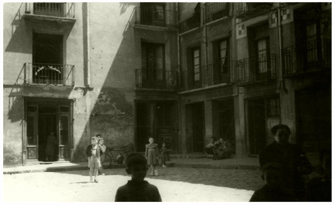
This sector was bounded by the inner wall (to the north and west) and the stone wall (to the south), the don Bienvenist alley (to the east), and Los Torneros. One part of the sector falls within the parish of San Gil (the alley or small square of La Perera or of the Minor synagogue, 134 a section of Chevamillos, the vicinity of the Puerta de San Gil, and part of Calle San Gil) and another in that of San Andrés—whose church of the same name is in the heart of the Jewish quarter—(callizo San Andrés, Prunillo, and part of Chevamillos). 135 Simuel Parexo, Adret Aninay, and Simuel Muriel lived there (Figure 7).
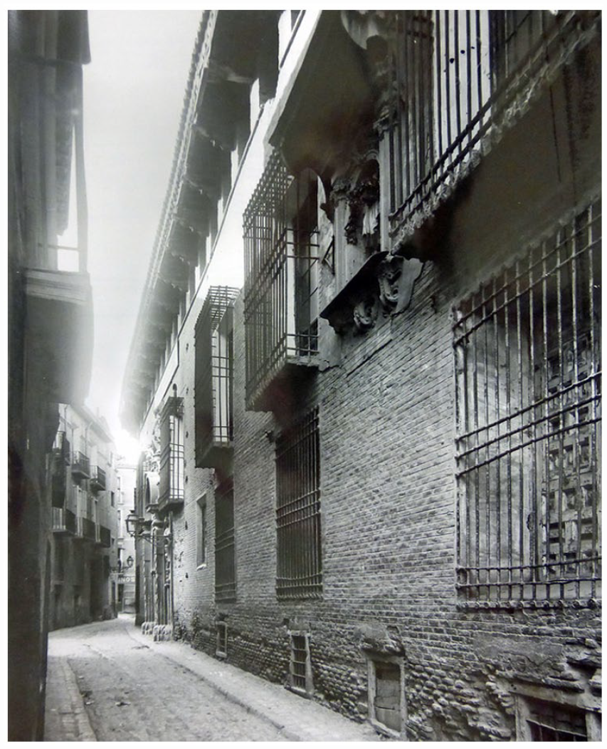
Calle San Andrés in 1918, where Iglesia de la Casa de Ganaderos was located.
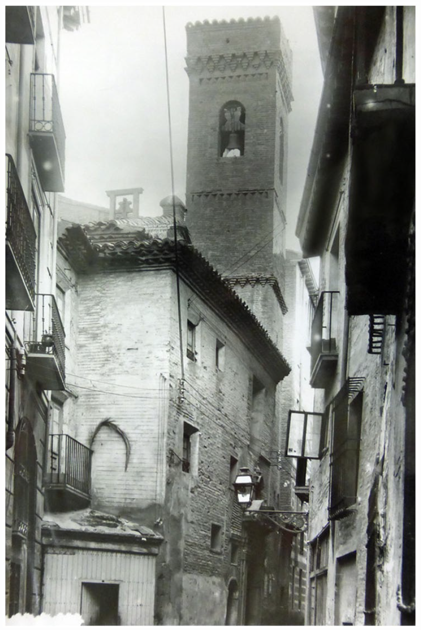
Synagogue of Biqqur Holim
This synagogue, which was also known as Visiting the Sick 136 or Los Torneros, stands on the artery of the same name, 137 currently Calle de la Verónica (Figure 8). Flanked by two public roads, a dead-end alley, and the houses of Juan de Burgos, a whitewasher, 138 Ferdinand II donated it after the expulsion to the monastery of Santa María de Jerusalem, a foundation of the royal secretary, Juan de Coloma. 139 In addition, as evidenced by the houses of Salamón Zunana (1,000 sueldos), Simuel Manuel (1,602 sueldos), Açach Baco, Salamón Abuzmel, and Salamón Nazir, it was close to the wall, since among its boundaries they cite the “puyada” (rise) of the wall. 140
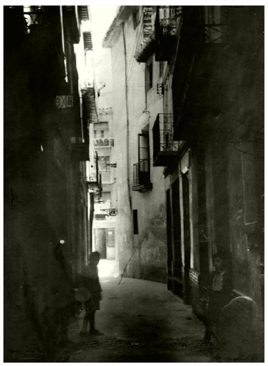
Calle de La Verónica (1951).
Public, Assistance, and Supply Centers
The Castle
Used as a jail for the Jews and archive for the aljama, the castle had seven stone towers, the wall, and “trastes de torre.” On one hand, it bounded on the street “vulgarmente dicha el Coso” and the Carnicería, on the other with a public street “por la qual se ba a la dicha Carniceria,” the “del Castillo de los jodios” square, the houses of Simuel Baço and of Simeon Rogat. Together with the Carnicerías, in 1492, it was donated to Juan Cabrero, a royal chamberlain, whose properties, after a financial agreement, became the property of the council in the Courts of Tarazona. 141 Until its acquisition by the company of Jesus, it would be used as an almudí (council-owned wheat warehouse).
This was an exclusive residential sector among whose residents was Salamón Atortox, one of its most powerful Jews, whose houses, with cellars to store wine—with a vat, among others, with a storage capacity of 130 loads—and oil were valued at 8,500 sueldos, 142 exceeding that of the charismatic house of the Talmud.
Brotherhood of Talmud-Torah
This was where Hebrew law was taught. It was in front of the tower of Puerta Ferriza, in calle Cíngulo. This road disappeared together with Yedra and Sartén streets, and Plaza de la Cebada, when Calle San Vicente de Paúl was opened. Calle Cíngulo connected Calle Santo Dominguito de Val and Calle San Jorge. In the surroundings, high-quality dwellings were located—“que son buenas casas, e por lo sobredicho no se troba quien las quiera comprar, las quales casas ganan mucho en fazer la dicha policia y faziendo crehe se fallara mayor precio del que de present dan en ellas” (although they are good houses, because of their location in a degraded urban environment, it is necessary to demolish some of them to increase their value and sell them at a higher price). Specifically, the value of Brotherhood of Talmud-Torah was established in 4,000 sueldos. 143 In fact, in the subsequent auction, the jurors highlighted the high patrimonial value, awarding it to the notary Domingo Salabert for 4,400 sueldos. 144 Inherited by the Sora family, the Marquesses of Torrecilla, Brotherhood of Talmud-Torah, was turned into a Renaissance palace.
Hospital
The property was valued at 910 sueldos 145 and was managed by Baruc Aciz and Mira Cohen, “hospitaleros,” and Ester de Salinas, widow of Rabbi Simuel. 146 Its houses adjoined the houses of Namías el Cofretero, Jehudá Perfet, and Jehuda Algranati (1,500 sueldos), between the alley of Los Torneros and the alley of El Toro—Calle Pardo Sastrón 147 —not far from the Plaza del Castillo and close to the Biqqur Holim synagogue. It had nine beds and two straw mattresses. The building had two palacios (rooms next to the porch on the ground floor), five cámaras chambers, and two latrines. 148
Bakery
This did not have the ritual significance of other places, but did not lack it altogether, given the Talmudic regulation of the Pesah festival, when unleavened bread (“cencenyo” or “cotaço” 149 ) was cooked, compared to “pan lindo” or ḥame, and consumed daily. Next to the Carnicerías, the Castle, 150 the Main Synagogue, and the wall, Juan Pérez had an oven or corral, later owned by Francisco Bojons. 151 Likewise, within the walls, there was the old bakery—which was owned by Jaco, Mossé, or Salamón—next to the miqwé. 152 The complex was made up of some houses, a corral, and a bakery. It became the property of Domingo Benedit, chaplain of Santa Cruz; perhaps due to lack of use, it was confiscated. 153
Butcheries. 154
Its existence dates back to 1135. 155 It is an isolated property, very close to the wall, which was accessed from the street of the same name, “asaz cerqua del dicho Castillo, en do se vendian carnes a los ditos jodios” (near the castle where Jews sold meat). 156 It is a single-story building, perhaps semi-circular, with two gates, the main or outer door, in the vicinity of Puerta Ferriza, and the rear or “çaguera,” which led into Coso. 157 It consisted of five meat cutting boards and a sixth where the sisa (consumption tax) was paid, as well as two corrals, the larger for the oxen and the smaller for waste. 158
When it was demolished in 1500, along with Puerta Ferriza, a stretch of wall and some houses, the result was a small space, which was later expanded with “la carrera publica por donde sallian de Barrionuevo.” The properties were demolished by the council and this created a square with the following dimensions: 9.75 cubits (7.5 m) × 15.3 cubits (11.75 m) × 6 cubits (4.6 m) × 23 cubits (17.7 m) × 11.4 cubits (8.7 m). 159 This way, a square was configured open to Calle de las Carnicerías, which can still be seen in the plans from the eighteenth century.
Bercería
The fresh food market 160 was called Bercería or Cuvequia, 161 indistinctly. 162 It was located in an important artery, since it is described as a carrera. 163 In some segment of this, two ways converged. 164 Some dead-end alleys have been identified as a way of access to a significant number of dwellings. 165 It is possible that a tavern where kosher wine was sold was located nearby, since we know that there were two establishments of this type. 166
The wall of the Jewish quarter reached the Calle Mayor, in the sector closest to Coso. This is evidenced by the lease for León Bilforat’s house, “en la carrera Mayor donde se vendia fruyta” (in the carrera where fruit was sold), signed by a beneficiary of the church of San Pablo. 167 This expression was repeated in that of Jucé Bilforat, bounding on the previous one. 168 It was a commercial area where the broker Namías Abenbitas had four houses (5,200 sueldos), and Açach Abuzmel, another four with shops included (1,000 sueldos). 169
Jucé Leredi, Açach Ovex (1,500 salaries), Açach Gallipapo (1,060 salaries), Mossé Obeig (800 salaries), Zacarías Afla, Mossé Cohen, Abraham Abenlopiel, Gento Ayeno, Abraham Carruch, Ezmel Abendino, Simuel Pico, Simuel Alfrangil, Saúl Abenazra and Salamón Trigo had houses in the neighborhood. 170 Sociologically, it was diverse, with merchants living side by side with artisans. 171
Miqwé
Moral purity, concomitant with physical purity, was a haláhika requirement, 172 and water was paramount both in its ceremonial and hygiene aspects, served by public baths. 173 The ritual bath or miqwé appears as a “baño frío” 174 or “baño de las mujeres.” 175
This installation appeared in the junction of the house, corral and the bakery, 176 and it was near the wall, the castle, Simuel Abenlopiel’s corral, and an entrance alley. 177 One year after the expulsion, the bathhouse, together with the palace and two small corrals, was rented by the squire (Francisco de Aranda) for 400 sueldos. 178 In successive operations, it was confirmed that around it there were patios, corrals, warehouses, and cellars. 179 In the square created after the demolition of the Carnicerías, there was a corral “por donde salle el agua de la calle de Barrionuebo,” 180 whose overflow flowed into Coso, 181 through which a branch of the Romareda channel runs. 182
New Jewish Quarter or Barrionuevo 183
Outside the walls and well-endowed with water, this area housed numerous tanneries. 184 Around 1415, the monarch respected its configuration, given that there were no Christians there: “que los judios no sallisen de los ditos calliços, sguardado que ningun christiano no stava ni habitava entre ellos” (that the Jewish did not leave the neighborhood considering that no Christian lived among them). 185 This fact is supported by the documentation, where the only confrontations with the Christian population occurred in the peripheral area of Coso.
Habitat
The Barrionuevo, or “Calliços” Jewish quarter, was in the parish of San Miguel, laid out in a herringbone pattern, with a first-rate street, Coso, in an east–west direction, and seven secondary north–south streets. Originally the six blocks that made it up measured about 100 m. They were divided into plots 5 m wide and 16-21 m deep. As a rule, these come from the partition of each block into two with a longitudinal dividing wall. 186
The model maintained the medieval Christian urban layout, with a modest population of artisans. It is outside the stone wall, but had the protection of an Islamic rammed earth wall. The Jews only occupied three alleys: Primero (Arco), Medio (Sinoga, Agua), and Zaguero (Susano, Acequia, Tenerías, Arriba). The names of these alleys (First, Middle, and Last alley) referred to the proximity of Puerta Ferriza. It was probably the only a residential area, with the baths surrounded by corrals, lots, or stables, as there are no mentions of dwellings outside this sector.
These alleys are drawn between Calle San Miguel and Coso (currently, Flandro, Hermanos Ibarra, and Rufas streets), in one of which the San Jorge alley ends (Figures 9 and 10). The topography drops slightly, where the point furthest from Puerta Ferriza was called Susano (the one above). 187
Calle del Cíngulo and a partial view of the facade of the Salabert family palace, ca. 1911.
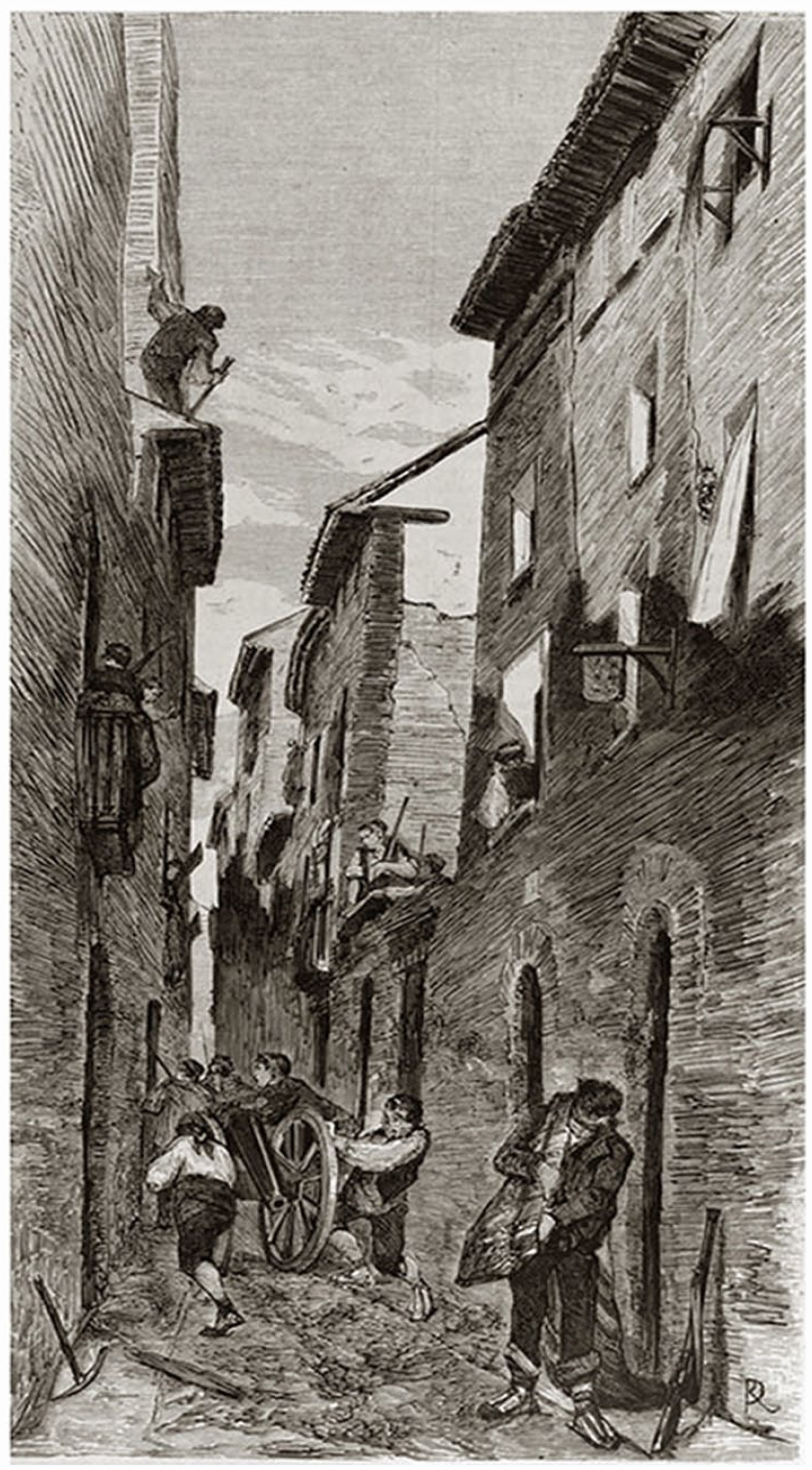
Illustration from calle Flandro (1808).
Moreover, at the mouth of the Medio alley, there was a gate, in the vicinity of which Merdohay Pexquer and Gento de la Rabica lived. There were also properties belonging to Salamón Abuzmel and Salamón Rodrich. 188 The inquisitorial sources identify the “portal del dicho calliço” at its mouth with the Coso. 189 The same is found with Primero alley, 190 so it is likely that all three had the same connection.
Houses and workshops alternated with one another without the facades being aligned. There was a proliferation of passageways, raised or underground, to link different dependencies located on other sections of the street.
Public Baths
Located in a semi-basement in the building at number 132-36 of Coso, below the original level, in front of the castle and the Main Synagogue, they follow the layout of the eleventh-century Taifa baths. They were a Mudejar work, whose oldest reference dates to 1266, with formal Cistercian elements (Figure 11).
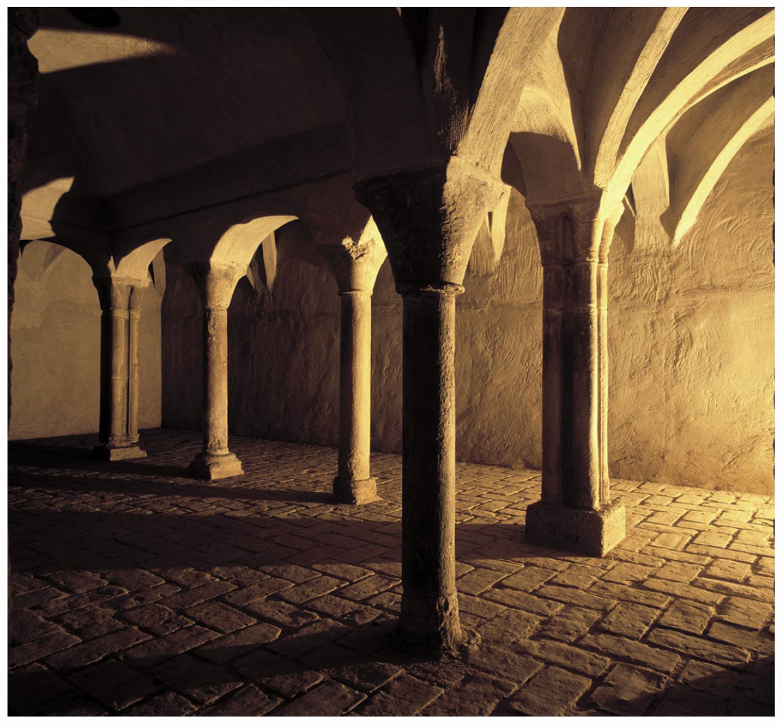
Public baths from the Jewish quarter.
The complex had a hot- and cold-water system, managed by “banyadores” who attended to the boilers and the supply of firewood. 191 There were two rectangular rooms measuring 9 m × 4 m and 9 m × 7 m, with an independent entrance, covered with a pointed half-barrel vault. The arches, which barely reached the semi-circular arch, rested on alabaster columns, the interior ones cylindrical and four stylised semi-columns at the angles, with plain and frustoconical capitals, some with gorgerin. 192
Barrionuevo Synagogue
This synagogue had access from the Medio alley, at the mouth that led to Coso, 193 on the right considering San Miguel as the reference, and from the Primero alley. 194 In the surroundings, there were the houses and tanneries of Jucé Abuzmel, Jucé Alcolumbre, Abraham Arruesti, Jucé Carrillo, Salamón Orabuena, Salamón Zaquén, and Jaco Alán, 195 as well as various corrals. 196 It had a tribune for women—rooms are mentioned “debajo de la sinoga de las mulleres” 197 —differentiated from the synagogue “mayor de los judíos hombres,” which was accessed by a separate route. 198 It also had a room for the “Scuela de los jodios.” 199
Epilogue
Shortly after the exile, the “veedor de carreras,” in charge of the state and maintenance of public roads, 200 received 14 sueldos for cleaning up the neighborhood—like his counterparts in Huesca 201 —and a Mudejar, 4.5 sueldos for the purchase of fifteen hundred nails for the damage that the neighborhood had suffered. 202 This shows that, from very early on, it was subjected to vandalism and looting. This is similar to what happened in the Jewish quarter of Teruel—where doors, eaves, and frames were ripped out to serve as firewood 203 —or in Albarracín, which served as a store for building materials, and soon turned into an open site. 204
The ruinous state of many homes was noticed months later. This explains why some properties were confiscated because their tenants did not pay the census. For example, in 1493, when Ramón de Labra, an infanzón (lesser noble), took possession of a property in the parish of La Magdalena, bordering Vidal Abnarrabí’s orchard, he warned of the poor conditions it was in, due to “la dirrycion et diterioracion de aquellas, las quales stavan todas muy dirruydas, cubertas, solares que stavan foradadas, truncadas et muchas viegas crebadas” (due to the deterioration of many houses, some of which have collpased, with fallen roofs, collapsed walls, or broken beams, almost completely destroyed). 205
In 1496, the juries warned about the ruinous state of many homes: “que las dichas casas venian de cada dia en ruyna y perdicion por no estar en ellas moradores, de lo qual se seguia muy gran danyo a la ciudat” (the houses were in ruins because no one lived in them, in detriment to the city). 206 Shortly after, it was emphasized that the houses owned by the council, due to having remained uninhabited, showed signs of ruin—“por no abitar ninguno en ellas ni repararlas de cada dia se diruyen e diminuecen”—despite repeated attempts to auction them off, “atendientes encara haver quesido vender las dichas casas e puesto aquellas venales, e no aber trobado quien dase en ellas el precio o stimacion.” 207 The process did not stop, because in the session held on the July 20, 1500, it was noted that “la dicha ciudat tenia muchas casas en Barrionuevo, las quales fueron consignadas por los comissarios a la ciudat, las quales havian mucho tiempo que se cridaban y es cierto ellas stan muy derruydas, que cada dia se pierden” (the city owns many houses that had been assigned to them by the royal commissioners in Barrionuevo, which have not been auctioned for a long time, so that they are in a very deteriorated state). 208
During the decade, the Council sold off the houses ceded by the monarch below their value, for 84,000 sueldos—compensation for the pontaje (bridge toll) and the custody of the Jewish quarter—and projected new roads or the widening of existing ones, as well as the demolition of buildings, even entire blocks, as already mentioned, to adapt the neighborhood to the new reality. Only after the Courts of Tarazona in 1495-1497 did the sovereign cede the management of the Jewish quarter to the municipality. However, given their complexity, these measures require a systematic and specific ad hoc study.
Footnotes
Acknowledgements
We are grateful to the editor and the reviewers who have contributed with their comments to improve the quality of this paper.
Declaration of Conflicting Interests
The author(s) declared no potential conflicts of interest with respect to the research, authorship, and/or publication of this article.
Funding
The author(s) disclosed receipt of the following financial support for the research, authorship, and/or publication of this article: This research is part of the I+D+I project, “El poder vivido en la Baja Edad Media: percepción, representación y expresividad en la gestión y recepción del poder” (Ref. PID2019-104085GB-I00), financed by the Spanish Government’s Ministry of Science and Innovation; and it was partially funded by Departamento de Ciencia, Universidad y Sociedad del Conocimiento, from the Gobierno de Aragón, Spain (Research Group S04_23R).”