
Abstract
Urban densification is widely regarded as a key strategy for promoting sustainability and fostering social diversity in cities. While it has often been advocated as a means to enhance social mix, research indicates that, without effective housing policies and regulations, it can instead drive up rents and property prices, leading to displacement and exclusionary pressures. In Oslo, the case study of this investigation, densification has been the primary development strategy, particularly in the historically less affluent eastern districts, where former industrial sites have been transformed into residential areas. We argue that when densification occurs within a fully deregulated housing system and is primarily driven by private developers and speculative investment, it tends to create conditions that facilitate exclusionary dynamics. However, the possible social implications can be different depending on the location of densification interventions. By analyzing census-tract level data on tenure structure, household typology, country background, education level, age structure, and income, we explore whether newly developed densification areas in Oslo exhibit a more homogeneous or socially mixed profile across the eastern and western parts of the city. Findings suggest that while densification areas in the east side of the city support gentrification dynamics, those in the west seem to rather have de-segregating effects.
Introduction
Over the past three decades, urban densification has gained recognition as a key strategy for addressing the climate and social challenges associated with rapid urbanization (OECD, 2012). It encompasses “a range of tactics aimed at constraining the expansion of urban areas, limiting the development of rural regions, and urban sprawl by revitalizing existing towns and cities” and increasing use density (Bibby et al., 2021: 2). Despite extensive research on the sustainability aspects of urban densification, studies predominantly focus on its environmental outcomes. As the empirical investigation of its socio-spatial implications remains scarce, this article aims to explore the multifaceted connections between urban densification strategies and their socio-spatial consequences in terms of residential segregation or desegregation. It explores how the implementation of densification strategies in Oslo can be associated with decreasing the city’s historically rooted segregation patterns.
Oslo is often described as a divided city (Wessel, 2015), with the river Akerselva separating the affluent west from the less affluent east. Although densification in Oslo has primarily been framed as an environmental strategy, it has also been promoted as a means to reduce residential segregation—by attracting higher-income residents to the east and introducing more affordable housing in the west. Through the analysis of the socio-economic composition of densification areas located both in the eastern and in the western side of the city, we explore whether these interventions have contributed to a more mixed residential environment compared to their surrounding neighborhoods. By doing this, we aim at answering the following research question: what are the implications of densification interventions on existing patterns of urban segregation/social mix in a city such as Oslo, characterized by a high level of macro-residential segregation?
To address this question, we analyze five key socio-economic variables: median household income, country background, education level, age structure, and household composition. We compare the characteristics of selected densification areas—situated on both the eastern and western sides of the city—with their surrounding administrative districts and the city as a whole. Our analysis reveals that most densification areas display distinct socio-economic profiles compared to their surrounding districts, suggesting a potential for increased social mix. However, they also face significant challenges—particularly gentrification pressures in the eastern parts of the city and limited rental affordability in the west.
The article is structured as follows. The second section reviews the literature on densification, urban segregation, and social mix. The third section examines Oslo’s existing segregation patterns, with particular attention to the east–west divide. The fourth section discusses the spatial distribution of densification areas and the narratives surrounding them. The fifth section outlines the case studies, data, and methodology. The sixth and seventh sections present and discuss the findings.
Impacts of densification on residential segregation: A literature review
Urban densification is widely promoted as a sustainable planning strategy, yet its socio-spatial consequences remain a subject of debate. This article contributes to the literature on the socio-spatial implications of urban densification by examining its associations with segregation at both neighborhood and city scales. While previous studies have explored the relationship between densification and socio-spatial dynamics, most focus either on gentrification risks or social mixing policies, without systematically addressing densification as a spatially differentiated process. Using Oslo as a case study, this article investigates how different spatial contexts within the city relate to socio-economic segregation patterns, offering new insights into the socio-spatial dimensions of densification policies.
Despite broad consensus on the benefits of urban density, densification remains a contested concept in both research and practice (Holman et al., 2015) and its acceptance or rejection has varied across different historical periods and geographical contexts (McFarlane, 2016).
On the one hand, urban densification is frequently defined as a tool to enhance social mixing, either at the urban or regional level (Rosol, 2015; Rousseau, 2015). Bricocoli and Cucca (2016) argue that the image of the dense, compact city in Europe is seen as a model for accommodating stratified and differentiated identities and improving social cohesion. This assumption rests on two key arguments. First, increased spatial proximity resulting from densification is believed to enhance social interactions and strengthen social ties (Cavicchia and Cucca, 2022). Second, compared to low-density development, densification offers a more varied housing supply and thus attracts diverse population groups (Aurand, 2010). The notion that density fosters urban diversity and economic vitality has been central to planning theory since Jane Jacobs’ seminal work (Jacob, 1961; Moroni, 2016), which identifies density as a key factor for economic vibrancy and urban appeal. This concept has been reinforced by numerous scholars over the years (Florida, 2019; Glaeser, 2011), prompting cities to adopt entrepreneurial strategies aimed at densification to attract the creative class (Rérat et al., 2010).
On the other hand, scholars have challenged the assumption that densification inherently promotes social sustainability (Debrunner et al., 2024; Kim and Larsen, 2017). Some studies have focused on the use of urban densification as a tool for social mixing policies, often leading to the demolition of social housing stocks and forced displacement of incumbent residents (Rosol, 2015). Others have explored how newly developed densification areas, which often feature upscale locations and expensive housing, end up only being affordable for wealthy residents (Yunda and Sletto, 2020). This process, known as “new-build gentrification,” occurs when upscale residential developments attract wealthier individuals, driving up housing costs and indirectly displacing lower-income groups (Davidson and Lees, 2005; Rérat, 2012; Rérat et al., 2010). Furthermore, scholars explore the possibility that such effects can spill over, causing exclusionary dynamics also in the surroundings of densification areas (Bardaka et al., 2018; Cavicchia, 2023b).
While research on densification and segregation has largely focused on gentrification and displacement, fewer studies have examined how socio-economic patterns vary based on the specific spatial location of densification areas within a city. Those that do (Götze et al., 2024) highlight three key risks in the absence of affordability measures: (1) the risk of gentrification in low-income areas; (2) the weak capacity of rebalancing macro-scale segregation dynamics; and (3) the risk of high-income group segregation in privileged areas and locations.
Bridge et al. (2011) argue how gentrification, defined as the influx of middle-income individuals into low-income neighborhoods resulting in the displacement of incumbent residents, is frequently flagged rhetorically and discursively as social mixing. Densification can lead to gentrification when implemented in lower-income neighborhoods through urban renewal projects and the construction of middle-income housing (Rosol, 2015). In these cases, densification’s potential to mitigate intra-regional disparities remains limited and rather risks reinforcing socio-economic polarization. This dynamic is evident in the case of the Lyon region, where densification was intended to counteract historic east–west inequalities (Rousseau, 2015). However, in the most affluent municipalities in the west, power dynamics and opposition from high-income, incumbent residents led to only minor, low-density interventions permitted (see also Bouwmeester et al., in this special issue). Meanwhile, in the less affluent east, densification efforts focused on transport-oriented development, aiming to attract middle-income residents rather than redistributing affluence across the region. Consequently, at a regional scale, densification failed to achieve its intended goal of fostering social mixing, instead reinforcing the socio-spatial divide between the east and west and triggering gentrification in the east.
Finally, the social composition of inhabitants in densified areas situated in very privileged locations often reflects a pattern of high-income segregation. The most emblematic cases are related to densification interventions along the waterfronts, where affluent groups are keen on establishing in luxurious neighborhoods with direct access to water (Andersen and Røe, 2017; Doucet et al., 2011; Keil, 2007).
Against this background, this study uses Oslo as a case study to explore how urban densification affects socio-economic segregation at both neighborhood and city levels. Moving beyond the binary debate on densification as either social mixing or gentrification, it examines how spatial location shapes socio-spatial outcomes. Through an exploratory analysis, the article highlights densification as a differentiated process that can reinforce, mitigate, or change segregation patterns.
Segregation and social mix in Oslo
Oslo has long been considered a divided city, with pronounced socio-economic polarization (Wessel, 2015) and segregation patterns traditionally stronger than in many other European cities (Tammaru et al., 2014). The river Akerselva, running north–south through Oslo, has served as a socio-spatial divider between the affluent west and the economically disadvantaged east since the 1800s (Wessel, 2015). Such division persists, with the west inhabited by the upper classes and characterized by single-family homes, urban parks, museums, and embassies, while the outer east is marked by highways, brownfield sites, and block buildings, with a higher proportion of low-income and ethnically non-Western residents (Andersen and Skrede, 2017).
Increasing levels of immigration have further strengthened the socio-spatial segregation patterns, as many immigrants have settled in areas already experiencing socio-economic deprivation. Turner and Wessel (2013) highlight the role of voluntary residential choice in explaining the residential minority group mobility, noting that some minority groups have remained loyal to the eastern edge of the city, despite their success in climbing the social ladder. Housing policies have also played a fundamental role in shaping segregation dynamics (Wessel and Lunke, 2021). Due to the neoliberal wave of the 1980s, Norway switched in a few years from a social homeownership housing model to a typically neoliberal housing system (Sandlie and Gulbrandsen, 2017). The Norwegian housing policy has been defined as poverty-oriented by Holman et al. (2015) and its tools as likely to exacerbate the existing dynamics of polarization. In Oslo, for example, municipal housing units as well as recipients of housing subsidies are mainly located in the most deprived eastern areas of the city. Although there have been municipal efforts to increase public housing in the wealthier west, the gap remains significant. As of 2018, east–west disparities were particularly pronounced in the outer city. The outer east had the highest share of residents with a non-Norwegian background, in contrast to the predominantly Norwegian-background population in the outer west (Cavicchia and Cucca, 2020). Although these demographic differences remain significant, some trends indicate a slight decrease in east–west polarization compared to previous years, primarily driven by gentrification in the inner east of the city (Cavicchia, 2023b).
Densification as a strategy for social inclusion in municipal plans
In Oslo, as in Norwegian planning more broadly, densification has become a dominant model of sustainable development since the 1980s (Næss et al., 2011). During this period, the greatest increase in population and building density was experienced within the municipal borders, particularly in the morphological city (Tiitu et al., 2021). This shift reflects strong local efforts to curb urban sprawl by prioritizing densification in the inner city and near transportation hubs, with a focus on redeveloping brownfields (Municipality of Oslo, 2018).
While densification has primarily targeted the inner city, it has been disproportionately implemented in the eastern districts. This is linked to various reasons. First, the east has a significant legacy of brownfield sites from the deindustrialization of the 1980s. Second, the western part of the city presents many more small single-family house areas, where the Small House Plan (Småhus Planen) restricts physical changes (Andersen and Skrede, 2017). The plan has been criticized for reinforcing socio-economic inequalities by favoring elite interests (Andersen and Skrede, 2017). Furthermore, residents in western Oslo, due to their higher educational and economic status, have greater influence in resisting densification projects in their neighborhoods.
While densification in Oslo is primarily framed as an environmental strategy, there is little emphasis on its potential role in fostering social inclusion (Cavicchia, 2023a). Concerning housing, municipal plans mainly pointed out the possibility, through densification, to increase the variety of dwelling types available, and create more mixed urban areas (Municipality of Oslo, 2000). In particular, densification has been regarded as a means to offer housing alternatives to single-family homes and townhouses, aiming to enhance residential stability within neighborhoods and address disparities in living conditions between the more affluent west and less affluent east of the city (Municipality of Oslo, 2008, 2015). However, affordable housing strategies remain largely absent from these plans, with the 2018 municipal plan’s vision being the only exception.
Case studies, data, and methods
Case selection
This article examines six newly developed densification areas in Oslo, aligned with the municipal strategy of densifying “from the inner to the outer city” (Municipality of Oslo, 2018). It explores variations in the social composition of these areas to assess whether such developments contribute to a more balanced social mix between the city’s east and west. Three areas were selected from the more affluent west and three from the less affluent east, each either fully or nearly fully developed. These areas primarily consist of block apartment buildings of six or more stories, with a smaller share of low-rise buildings up to three stories.
The analysis focuses on areas that have undergone complete transformation from their former commercial and industrial uses. Consequently, the data used in this study pertains to newly built housing developments and the demographic shifts associated with the influx of new residents since the early 2000s. Based on these criteria, we selected Løren, Ensjø, and Kværnerbyen in the eastern part of the city and Skøyen, Pilestredet Park, and Majorstuen in the west for in-depth analysis (see Figure 1).
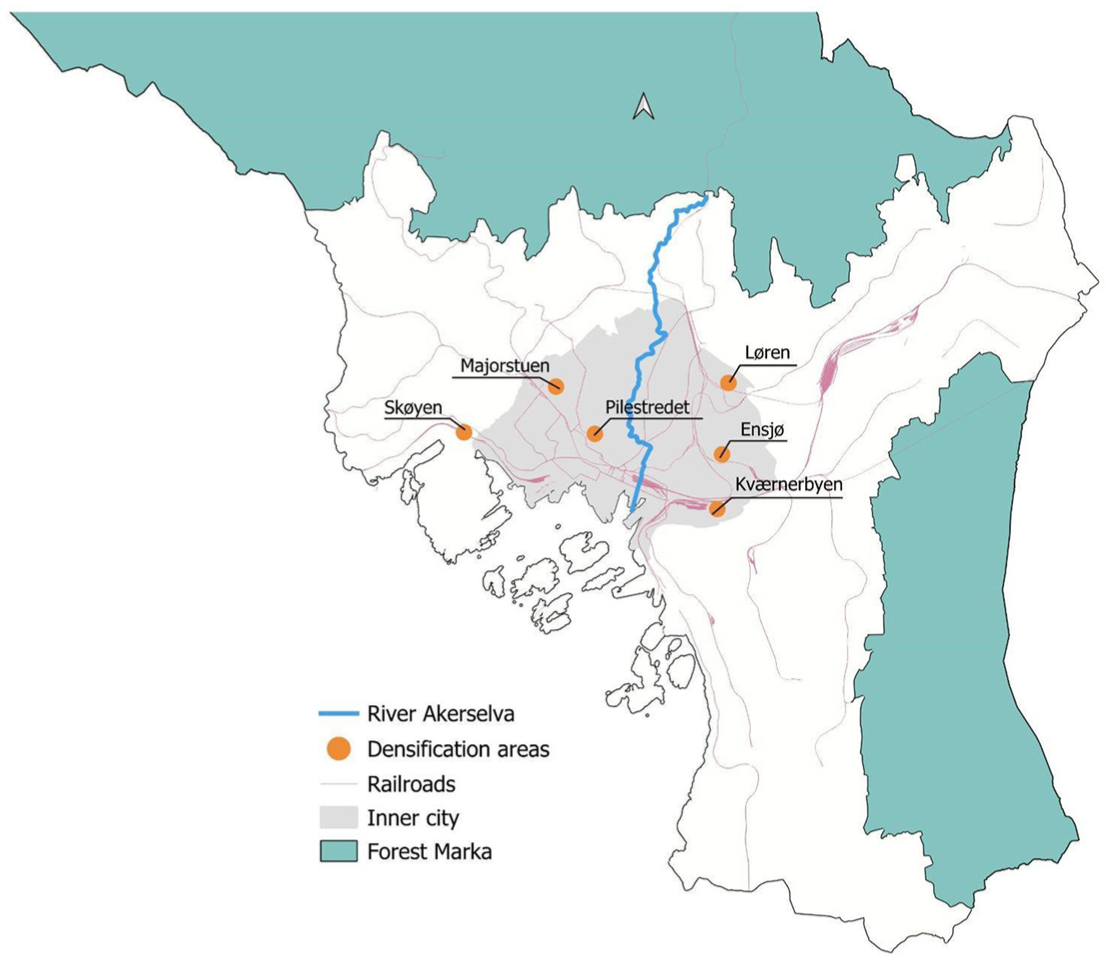
Selected densification areas.
Løren, in the district of Grünerløkka, has undergone significant transformation since 2002. Once home to industrial, production, and military facilities, it is now a modern residential area catering primarily to families, with 68% of apartments featuring three or four rooms (see Table 1). The community benefits from several playgrounds, new primary and secondary schools (opened in 2015 and 2011, respectively), and a metro station operational since 2016 (Cavicchia, 2023b).
Selected case studies and data on population size, share of renters, apartment size, and development status.
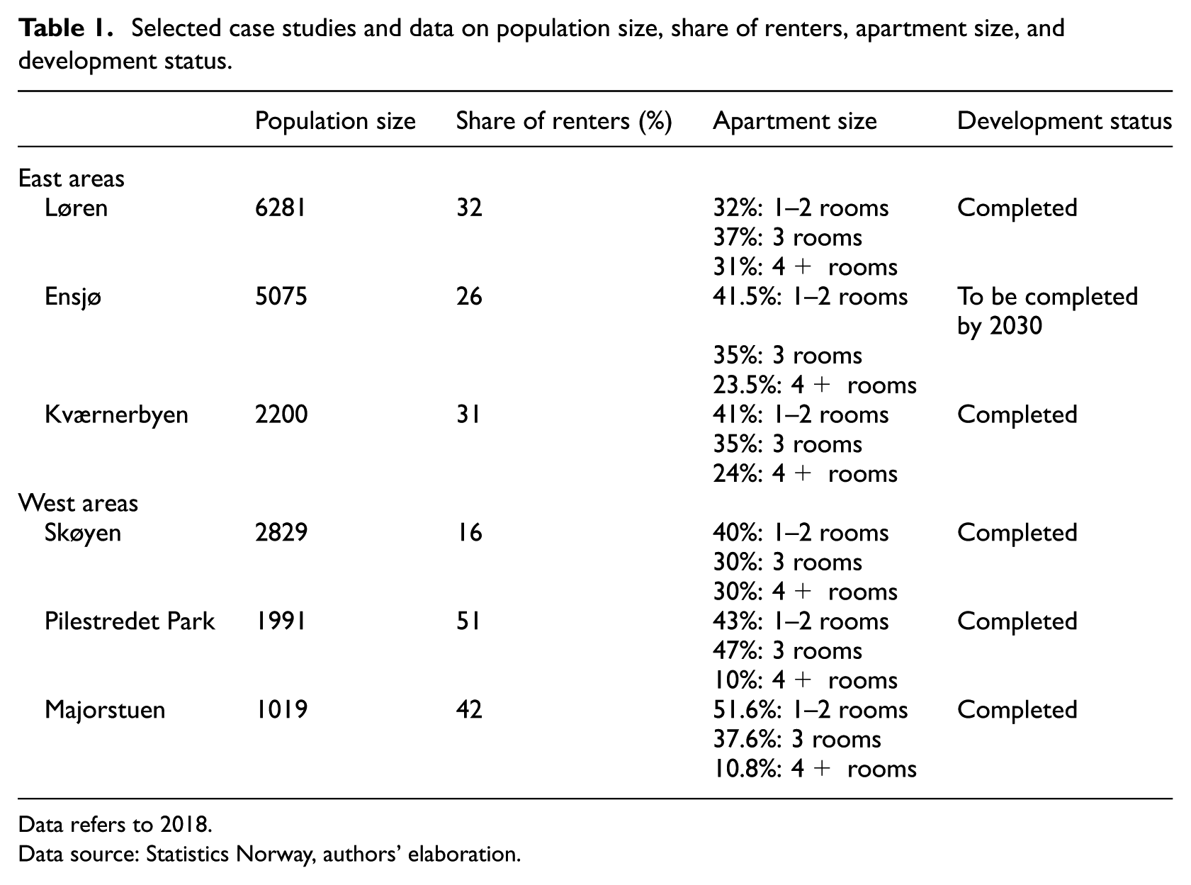
Data refers to 2018.
Data source: Statistics Norway, authors’ elaboration.
Ensjø and Kværnerbyen are located in the administrative district of Gamle Oslo, which extends from the city center to the eastern border of inner Oslo. Ensjø, once dominated by car dealerships, is expected to be fully developed by 2030, transforming into a hub with 7000 dwellings (Municipality of Oslo, 2021). Currently, it has around 2500 dwellings and a metro station, opened in 2013, just four stops from Oslo Central Station. Unlike Løren and Ensjø, Kværnerbyen was not planned with a large-scale vision or a transit-oriented approach. Development began in 1999 when OBOS, Norway’s leading housing developer, redeveloped the site following industrial closures. Now fully developed, Kværnerbyen housed 2200 residents as of 2018.
Grünerløkka and Gamle Oslo, home to these eastern densification areas, have historically been diverse, working-class neighborhoods with the lowest income levels in inner Oslo. However, both have undergone gentrification: Grünerløkka has seen significant social changes over the past three decades (Hjorthol and Bjørnskau, 2005), while Grønland and Tøyen have seen more recent transformations (Andersen et al., 2020; Huse, 2016). As shown in Table 1, the proportion of tenants in these eastern densification areas aligns with Oslo’s overall tenant level of approximately 30%.
In western Oslo, Pilestredet Park, located in St. Hanshaugen, is the most central of the study areas. Built on a former hospital infrastructure (Rikshospitalet), it is one of Scandinavia’s largest urban ecology projects, featuring high-energy-efficiency buildings, extensive green spaces, and an advanced stormwater management system. Developed by Skanska and OBOS, the area is characterized by small apartments (about 90% have 1–3 rooms) and a high tenant share (51%, about 20% above the municipal average).
The areas of Majorstuen 1 and Skøyen, in the affluent districts of Frogner and Ullern (the latter outside the inner city), were once dominated by industries, banks, and offices before densification projects replaced them. The developments differ: Majorstuen has a high number of small apartments and rental units, whereas Skøyen features larger apartments and a lower tenant share (16%; see Table 1).
Data and methods
This study employs a longitudinal analysis covering the period from 2005 to 2018, using quantitative data to describe the socio-economic composition of selected densification areas. The socio-economic composition of densification areas was then compared with their respective administrative districts as well as with the whole municipality of Oslo. The dataset, obtained from Statistics Norway through an associated research initiative, provides the most recent available data as of 2018. Although this does not reflect the most current year of data availability, examining the status and change of densification areas between 2005 and 2018 provides valuable insights into the implications of densification on existing patterns of segregation and social mix. A key limitation is that some densification areas were in early development stages in 2005, resulting in smaller initial populations. 2 Consequently, neighborhood change data should be interpreted with caution.
The analysis focuses on five main data variables.
(1) Household median income level.
(2) Country background, 3 classified by Statistics Norway as: Norwegian; Western European countries plus USA, Canada, New Zealand, and Australia; Eastern European countries included in EU; and Asia, Africa, Latin America, plus Eastern European countries outside the EU.
(3) Household composition, based on the following groups: households without children (including single and couples); and households with children (including couples and single parents).
(4) Age structure, categorized into four groups: 0–19, 20–29, 30–49, and 50+ (available only for 2018).
(5) Education level measured by the share of residents with higher education (undergraduate, graduate, and postgraduate).
To complement this analysis, additional data on tenure composition, apartment size, and household median income by country background in each densification area (see Table 1) was examined. All data is analyzed at the census tract level. Notably, Oslo’s census tracts align with the densification areas studied, ensuring analytical accuracy.
Finally, findings are contextualized using results from existing studies on Oslo’s densification policies (Cavicchia, 2021, 2023a, 2023b), which provide insights into policy motivations, the emphasis on social mix, and broader urban dynamics.
Findings
Eastern densification areas: Supporting gentrification?
The densification areas on the eastern side of Oslo have in common that they are areas built on brownfields, where formerly industrial, commercial, or military areas (as in Løren) were located. When analyzing their socio-economic composition, key patterns emerge.
In 2018, median household income was higher in all densification areas compared to their respective administrative districts. This was particularly evident in Løren, where the median income was on average 21.7% higher compared to the district of Grunerløkka and 15.5% higher than the whole municipality of Oslo. In Ensjø and Kværnerbyen, income levels were also higher than in Gamle Oslo (by 10.2% and 8.2%, respectively) but slightly below the city average. This suggests that while the income level in these two areas was relatively low in the context of Oslo, it still contributed to bringing higher-income people within Gamle Oslo, which is the district with the fifth lowest income level in the whole municipality. Since 2005, income levels have risen across all areas, though data interpretation should account for their small initial populations.
In contrast to income trends, the proportion of highly educated individuals in all three areas was lower than in their respective districts and in Oslo as a whole in 2018. However, education levels have consistently risen since 2005, suggesting that more recent data may show different patterns. Regarding country background, in 2018 Løren showed a share of immigrants from non-western countries higher than those in both the district of Grunerløkka (about 28%) and the whole municipality of Oslo (+20.5%). Conversely, there was a lower share of native Norwegian individuals and of immigrants from western countries. Notably, the income level of non-Western immigrants in 2018 in Løren was about 8% higher than the median income in Grünerløkka, though about 7.5% lower than the overall municipal average. This suggests that households with an immigrant background living in Løren are not economically disadvantaged. In Ensjø and Kværnerbyen, the opposite trend was observed: both had more native Norwegians (+3.2% and +6.1%, respectively) and fewer non-Western immigrants (−4.9% and −9.8%%, respectively) than Gamle Oslo. The median income level, both for natives and for immigrants, 4 is however not as high as in Løren (about 15% lower than Løren in both areas) but is still higher than in the district Gamle Oslo, and the median income level for non-western immigrants is remarkably lower than in the district of Gamle Oslo (−7% for Ensjø and −11% for Kværnerbyen). The most notable shift since 2005 occurred in Ensjø, where the share of non-Western immigrants increased while that of native Norwegians declined. However, given that the number of households in Ensjø nearly doubled in this period, caution is needed in interpreting this trend.
Kværnerbyen stands out for its high proportion of single-person households and young residents (28% in the 20–29 age group, compared to 22% in Løren and 18% in Ensjø). This younger demographic, likely at the start of their housing careers, may explain the area’s lower income levels. Additionally, about 30% of the households are renters, a group that typically has a lower income than homeowners (Haffner and Hulse, 2021).
Other interesting patterns emerge when looking at the household composition for these areas. Løren and Ensjø, for example, have been largely targeted at families. While in 2018 households without children (both single and couples) constituted the majority in both areas (about 65.5%), this percentage was actually 12.2% lower in Løren and 8.7% lower in Ensjø compared to Grünerløkka and Gamle Oslo, respectively. Conversely, the proportion of households with children aged 0–17 years (both couples and single parents) was higher in Løren and Ensjø than in their respective district areas—65.1% higher in Løren than in Grünerløkka, and 36.9% higher in Ensjø than in Gamle Oslo. In Kværnerbyen, the situation is remarkably different compared to the other two areas. Here, the share of households without children in 2018 was 74.6%, the highest among the densification areas in the east, while the share of households with children aged 0–17 was the lowest.
The age structure of the eastern densification areas reflects their household composition, with Løren and Ensjø characterized by a high share of population in the 0–19 age group (reflecting the high presence of families with children). In all three areas, the proportion in 2018 of individuals aged 50 and above was lower than in both the respective districts and the city of Oslo as a whole. The largest segments of the population are concentrated in the 20–49 age range.
Three main patterns seem to emerge from the analyzed data. First, the densification areas in the eastern part of Oslo are characterized by a higher income level compared to the wider administrative districts where they are located. This might be linked to various reasons: (1) these areas are characterized by homeownership as prevalent tenure form and have a share of renters that is lower than the districts of Grunerløkka and Gamle Oslo; and (2) as discussed in previous studies (Cavicchia, 2021), densification areas in Oslo are exclusively characterized by market-based housing and by very low housing accessibility levels. Second, two of the three areas analyzed, Ensjø and Løren, are strongly targeted for families and this contributes to more balanced distribution of household typologies compared to the districts of Grunerløkka and Gamle Oslo, where more than 50% of the households are single people living alone. This is interesting also in the face of studies that have criticized densification policies in Oslo for being unable to ensure the residential stability of young families. Families, indeed, often have to move outside central and semi-central compact areas as their household grows because larger dwellings are not affordable (Wessel and Lunke, 2021). Third, the age distribution across all eastern densification areas indicates a predominantly young population, with the largest proportion being in the 20–29 and 30–49 age groups. See Tables 2 and 3.
Socio-economic composition of the densification areas in the eastern side, in comparison with the administrative district and with the whole municipality of Oslo (years 2005 and 2018). 5
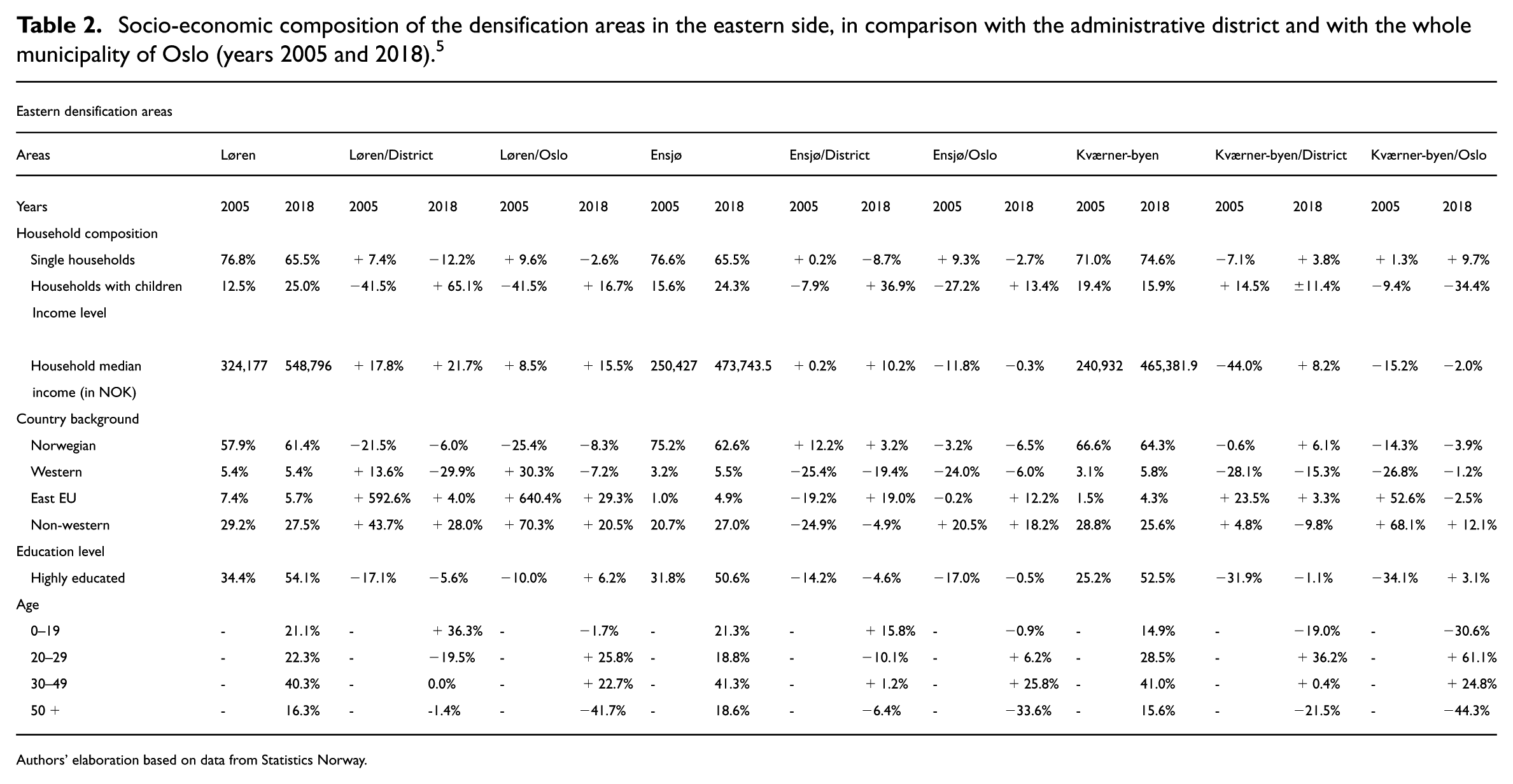
Authors’ elaboration based on data from Statistics Norway.
Socio-economic composition of the densification areas in the western side, in comparison with the administrative district and with the whole municipality of Oslo (years 2005 and 2018).
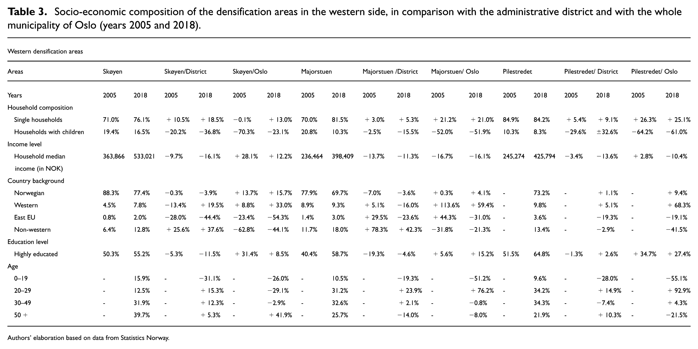
Authors’ elaboration based on data from Statistics Norway.
Densification in the west: Supporting social mix?
As previously noted, densification has been more extensively pursued in the eastern part of Oslo, whereas western densification areas remain comparatively smaller in both population size and physical scale. Similarly to their eastern counterparts, these western areas have also emerged through brownfield redevelopment. The analysis of census-level data highlights patterns related to the development of densification in the affluent areas of the west.
In terms of household composition, the vast majority of households in all areas were without children in 2018, ranging from 76.5% to 85% and showing an increase compared with 2005. In 2018, Skøyen had the highest percentage of households with children (16.5%) and Pilestredet Park the lowest (8.3%). Densification areas confirm their role as privileged residential choices for singles and couples without children, in comparison both to the districts where they are located and to the city of Oslo in general. In terms of income distribution, the densification areas show a lower profile compared to the affluent districts of the west. While Skøyen scores higher compared to the city of Oslo in general, Majorstuen and Pilestredet Park present an overrepresentation of residents with lower income, also compared with Oslo in general. In the case of Majorstuen, the gap is significant (about 16% lower than the median income level in Oslo). A similar trend is observed in education levels: throughout the period from 2005 to 2018, the share of highly educated residents in all western densification areas remained lower than in their respective districts, but consistently higher than the Oslo average.
The relatively lower income levels in these areas can be partially attributed to the overrepresentation of residents aged 20–29, who are likely at the beginning of their careers. This was particularly evident in Majorstuen and Pilestredet. In contrast, Skøyen had a notably high share of residents aged 50 and above in 2018, accounting for almost 40% of the local population—42% higher than the Oslo average. Income patterns in these areas also aligned with tenure composition. Skøyen has a particularly low share of tenants (around 16%), whereas Majorstuen and Pilestredet have significantly higher shares, at 42% and 51%, respectively.
In 2018, all areas had a higher proportion of residents with Norwegian and Western backgrounds, but lower proportions of immigrants from the Global South and Eastern Europe compared to Oslo as a whole. Both Skøyen and Majorstuen have also seen a notable increase in non-Western immigrants over time. In Majorstuen, specifically, the proportion of residents with Norwegian and Western backgrounds was slightly lower relative to the broader Frogner district, while that of non-Western immigrants was higher.
In summary, the densification areas in the west seem to contribute to decreasing the segregation of natives and high-income households in the districts where they are located, essentially bringing a more diverse population in terms of the socio-demographic profile of households. This is mainly due to a high offer of small-size apartments attracting singles and couples without children who are more likely to rent. Considering the high cost of renting in these areas and the lower median income of households in Majorstuen and Pilestredet Park, it would be significant to investigate the housing cost overburden rate in these areas as well as the distribution of the profit deriving from the rental of such units, which are currently unknown.
Limiting the east–west divide? Potentials and limitations
The comparison between the socio-economic compositions of the densification areas in the eastern and western areas of Oslo highlights interesting similarities and differences. In general terms, the newly built densification areas present profiles that are less homogeneous compared to the districts where they are located.
Regarding country background, we observe a higher level of immigrants from the Global South in the densification areas in the east, and more native households in the western districts. This shows the persistence of a broader-scale east–west divide, with an overrepresentation of native born Norwegians on the west side of the city and an overrepresentation of households with immigrant backgrounds in the east.
The availability of small or larger apartments (see Table 1) influences the household composition within the densification areas. We notice that some areas in the east are especially rebalancing the distribution of families with children, which is very low in the centrally located eastern districts. Those densification areas (both in the eastern and in the western side) with a relatively high share of households with children usually have higher median incomes and the highest percentage of homeowners. Conversely, the high share of renters in the western areas of Majorstuen and Pilestredet Park (42% and 51%, respectively, compared to an Oslo average of 32%), which are very attractive and centrally located, suggests that housing in these areas may function increasingly as an investment asset, potentially attracting private and institutional landlords.
It is essential to highlight two additional issues, consistent with empirical findings from other urban contexts. First, as noted by Rousseau (2015) in the peri-urban areas of Lyon, the affluent western side exhibits fewer densification areas due to a scarcity of available brownfields and strong local opposition to densification. This situation naturally impacts the densification’s potential for desegregation in these western areas. Second, there is a risk of gentrification on the eastern side, where spill-over effects and exclusionary dynamics for lower-income residents have been observed and documented in other analyses (Cavicchia, 2023b).
Discussion and concluding remarks
In this article, we have explored whether the creation of new densification areas in Oslo has contributed to reducing the existing patterns of segregation between the more affluent west and the less affluent east of the city. Moving beyond the binary debate of densification as either social mixing or gentrification, we have examined how spatial location can shape its socio-spatial outcomes.
The first aspect emerging from our analysis is that while the historical socio-economic divide between eastern and western sides of Oslo is still present, the densification areas seem to contribute to a better social balance. Indeed, the densification areas in the less affluent eastern areas of Oslo present a higher socio-economic profile compared to the districts where they are located; those in the west present the opposite tendency.
This main pattern seems to suggest a desegregating potential of densification, supporting studies and theories that argue for the potential of densification to create more mixed communities compared to lower-density development (Jacob, 1961; Ståhle, 2017). However, the analysis in this article underscores the need to nuance this debate. Our findings demonstrate that the potential desegregating effects are not solely a result of densification interventions as such but of a complex set of factors that play an important role.
First, the tenure structure is a determinant factor to explain the household composition as well as the income level of the densification areas. Those on the western side, which present the highest percentage of tenants (Majorstuen and Pilestredet Park), have an income level that is remarkably lower not only than the western districts but also when compared to the densification areas in the east. This reflects the income gap that notoriously exists between renters and homeowners (Haffner and Hulse, 2021). Furthermore, while a higher presence of rental units might be seen as an opportunity in the context of a city such as Oslo, where homeownership is the main tenure form, it should be considered that in these districts rent prices are the highest of the city. 6 The scale of the available data on rental price does not allow us to assess housing affordability conditions within densification areas, but housing cost overburdens can be strongly expected, as happens in other contexts (Debrunner et al., 2024; Ronald and Kadi, 2018).
Second, the size of the apartments present in the different densification areas is another explanatory factor for their socio-economic composition. The areas of Majorstuen and Pilistredet, again, in addition to presenting the highest number of renters, also have the highest number of one- and two-room apartments. In these areas there is also the highest number of single households, a factor that gives further explanation for the relatively low median household income.
Third, when it comes to the country composition of the densification areas, patterns seem to mirror the existing east–west divisions, with a higher share of non-western immigrants in the densification areas located in the east. What is interesting, however, is that the income profile of this immigrant population is not necessarily low, confirming that the tendency for densification areas on this side of the city seems to also be attracting the middle class, given the high level of housing prices.
Even though, as mentioned, the main overall emerging pattern seems to be related to a better socio-economic balance in connection with densification interventions, some crucial shortcomings related to their socio-spatial implications should be highlighted.
The first is related to the fact that the densification areas in the east tend to attract higher-income households, confirming what new-build gentrification scholars discuss about the development of densification areas in attractive locations of the city (Davidson and Lees, 2005; Rérat, 2012; Rérat et al., 2010). Furthermore, as noted in previous studies focusing on these areas (Cavicchia, 2023b), the densification areas in this side of the city tend to create a spill-over effect where housing prices, and the income level of the surroundings of densification areas, have seen a remarkable increase between 2005 and 2018.
The second key drawback is that, while densification in western Oslo appears to attract less affluent residents to wealthier areas, these interventions remain sporadic and face strong opposition from local residents. Future research should explore the implications of densifying further west, where Oslo’s most exclusive single-family home neighborhoods are located.
Additionally, issues related to micro-segregation dynamics (Maloutas, 2020) should be considered in further research, in order to unpack potential trade-offs between social mix and inequalities in housing standards, living conditions, and stigmatization in densification areas. Densification can give rise to micro-segregation patterns, exemplified by the vertical dimension of inequality in new high-rise buildings and neighborhoods. In these newly densified areas, where market dynamics shape housing prices vertically, social stratification may manifest between apartments on upper and lower floors (Maloutas, 2020), influenced by individual economic status as well as by housing preferences and strategies (Flint, 2017).
These shortcomings also underscore the need to consider important policy implications. First, the use of segregation indicators in Oslo is currently limited to areas subject to a redevelopment program, excluding new developments. A more comprehensive application of these indicators could help guide the location of densification areas and inform their implementation, ensuring a better mix of residents. Second, the potential for implementing inclusionary zoning (Götze et al., 2024)—currently not supported by law in Norway—should be explored as a means of promoting a more diverse housing mix within densification projects.
Finally, comparative investigations into the implications of densification for desegregation across various housing regimes are needed. As highlighted by Haarstad et al. (2023), it is crucial to pay close attention to how the dominant agenda of densification functions and adapts within different contexts and might shape intra-urban inequalities. While residential densification has the potential to mitigate existing segregation patterns, in-depth analyses are required to determine whether it might also have conflicting implications for housing inequalities, particularly regarding housing affordability and quality.
Footnotes
Acknowledgements
We are grateful to the anonymous reviewers for their insightful feedback, and to Gabriela Debrunner, David Kauffman, and Justin Kadi, co-editors of this Special Issue, for their valuable comments on this manuscript. We are especially thankful to Petter Næss, whose ideas and guidance have inspired this work in many ways.
Funding
The authors disclosed receipt of the following financial support for the research, authorship, and/or publication of this article: European Commission, European Research Executive Agency, Project 101132540—ReHousIn.
Declaration of conflicting interests
The authors declared no potential conflicts of interest with respect to the research, authorship, and/or publication of this article.