
Abstract
The New Urban Agenda’s call for long-term visions in urban planning fails to recognise that ‘long-term’ implies different longevities depending on context of assessment. Compared to other social sciences, archaeological approaches add rigour to envisioning urban sustainability over several centuries and millennia. The archaeology of the pre-Columbian Lowland Maya urban tradition is an interesting case because data have been used to support conflicting arguments about Maya urban sustainability. We suggest that these contradictions can be partly explained by: (1) sustainability being ambiguously defined, (2) subsets of the urban system being expected to indicate the behaviour of other subsets or of the entire system, and (3) processes being evaluated using different timescales. Drawing on 1500 years of urban history at Tikal, this paper examines how archaeological perspectives add depth of reflection and unfold critical assumptions of the meaning of ‘long-term’ and ‘sustainability’ concealed in self-explanatory notions. We outline the development and longevity of urban settlement at Tikal and analyse the blue-black-green (water, soil, vegetation) infrastructures that sustained urban metabolism and sponsored basic urban functions. Our analyses contribute new insights on the challenges associated with future sustainability transitions over varying temporal scales. The diversity of past and present urban systems and infrastructural initiatives cannot be fitted within a single narrative of urban sustainability, however, and much research is required to examine how blue-black-green infrastructures can support transformative change of aggregated human population zones struggling with potable water scarcity, soil degradation, and habitat and biodiversity loss.
Introduction
The New Urban Agenda (NUA) (UN Habitat, 2017) calls for the creation of long-term visions in adaptive urban planning and design, but it does not recognise that the concept of ‘long-term’– central to sustainability thinking – is relative and implies different longevities depending on the disciplinary context of assessment (Lane, 2019). Archaeologists argue that their perspective of time complements those of other social sciences by extending the temporal depth of analyses to detail the causal relationships of socio-ecological change over several centuries and millennia (van der Leeuw, 2020), adding considerable temporal depth and rigour to assessing and envisioning urban sustainability.
Some of the most cited cases suggesting the expediency of archaeological research to generate insights on long-term urban sustainability are the cities of the pre-Columbian central Maya lowlands of southern Mexico, northern Guatemala, and Belize (Chase and Scarborough, 2014; Turner and Sabloff, 2012). These cities are compelling because, whilst sharing many characteristics common to all cities, they are distinct in various ways (Hawken and Fletcher, 2021), motivating reflection on what they can tell us about urban sustainability in the present, including evidence for resilience and sustainable resource use (Dussol et al., 2021), alternative sustainable developmental paths (Scarborough and Isendahl, 2020), regenerative food systems (Lentz et al., 2014), management of complexity (Scarborough and Burnside, 2010), resource and water use in marginal environments (Scarborough et al., 2012), and soil management (Evans et al., 2021). The Maya urban tradition does not have the recognisable urban grid structure of Chinese or Japanese cities or the dense residential cores of European Medieval cities. Instead, the Maya developed a complex bio-circular relationship with blue-black-green (water, soil, vegetation) infrastructures that were interspersed within the settlement to form a fractal (Brown and Witschey, 2003) or dispersed pattern (Graham, 1999) that has been described as an integrated agro-urban landscape (Isendahl, 2012). These ‘living’ infrastructures are different from what might be called inert or ‘grey’ infrastructures in modern planning terminology (Bartesaghi Koc et al., 2017), and are particularly helpful in the insights their study offers on resource use in the wider biophysical landscape.
Blue-black-green infrastructures (cf. Andersson et al., 2014) are conceptual tools for examining how resource support systems central to the metabolism of Maya cities integrated with the development of urban form (Isendahl et al., 2021). Nascent Maya urban societies emerged in the later Middle Preclassic (1000–400 BCE), and by the later Classic Period (250–900 CE) the region consisted of a series of powerful city-states with a combined population possibly totalling around 10 million (Canuto et al., 2018; Scarborough and Burnside, 2010). The archaeology of pre-Columbian Lowland Maya urbanism is particularly intriguing because data have been used to support arguments of, on the one hand, long-term urban sustainability and, on the other, economic overshoot, environmental degradation, and socio-political collapse (Chase et al., 2023). We suggest that competing narratives do not simply mirror multiple pathways among different Maya urban histories but can, to a significant degree, be explained by variations in how key concepts and frames of reference are applied: (1) sustainability may be poorly or ambiguously defined, (2) subsets of the urban socio-ecological system may be expected to indicate the behaviour and properties of other subsets or of the entire system, and (3) processes may be evaluated using different timescales. In particular, the meaning of ‘long-term’ and ‘sustainability’ are often obliquely assumed rather than explicitly detailed – a poor basis for comparing past and present urban development. The relative absence of sustainability research that links consideration of both past and present cities limits the ability to answer questions about the development of long-term regenerative infrastructures fundamental to bio-circularity, resilience, sustainable resource use, and intergenerational and cross-cultural equity in urban systems.
This paper revisits the pre-Columbian Lowland Maya city of Tikal to examine how archaeological perspectives on time may help to unfold critical assumptions of the meaning of ‘long-term’ and ‘sustainability’ concealed in self-explanatory notions. Research over more than half a century at Tikal has generated archaeological and palaeoenvironmental datasets that indicate settlement history (including demographics and construction investment) and resource management (water, soil, vegetation) over more than 1500 years (for an overview see Lentz et al., 2015). We outline the development and longevity of urban settlement at Tikal in qualitative narratives, assuming that persistence of settlement is a useful preliminary indicator of urban sustainability (Smith et al., 2021). Because the civic-ceremonial core is the most well-documented zone at Tikal, changes in large-scale building activity are used as a preliminary proxy for urban development trends. We then examine more closely the compelling bio-circular systems within Maya society – the blue-black-green infrastructures that sustained Tikal’s urban metabolism and sponsored basic urban functions.
Defining and charting urban sustainability
Sustainability has been used to advance a range of idiosyncratic arguments in widely different contexts, allowing diverse definitions and approaches to emerge (Bell and Morse, 2008; Caradonna, 2022; Matson et al., 2016). Here, we integrate three complementary definitions across archaeology and ecology.
Allen et al.’s (2003: 26) focus on supply-side sustainability as ‘maintaining, or fostering the development of, the systemic contexts that produce the goods, services, and amenities that people need or value, at an acceptable cost, for as long as they are needed or valued’.
Daly’s (2006: 39) definition of sustainable natural resource management as non-declining throughput, or ‘the [non-declining] entropic physical flow from nature’s sources through the economy and back to nature’s sinks’.
Wu’s (2014: 213) definition of urban sustainability‘as an adaptive process of facilitating and maintaining a virtuous cycle between ecosystem services and human well-being through concerted ecological, economic, and social actions in response to changes within and beyond the urban landscape’.
These definitions have been variously applied to both past and contemporary cities, but it is only with the articulation of Agenda 2030’s (United Nations, 2015) Sustainable Development Goal of sustainable cities and communities (SDG 11) and the NUA that a comprehensive and systematic consideration of cities has been prioritised (Hawken et al., 2021; Wiedmann and Allen, 2021). Aiming to function as networks of goals and agendas in a synergistic way, the SDGs and the NUA arguably verge on a necessary but ‘unmanageable complexity’. One way forward is to address Allen et al.’s (2003: 26) four-point query of the properties of sustainability: of what, for whom, for how long, and at what cost?
In response to ‘of what?’ and ‘for whom?’, we are concerned with urban sustainability (sensu Wu) at Tikal that – in our integrated conceptualisation – largely depends on the sustainable management (sensu Daly) of key natural resources soil, water, and vegetation to satisfy supply-side sustainability (sensu Allen et al.) of food and freshwater security as essential requirements for the well-being of Tikal’s entire population. We suggest that studies at the city level are significant but underdeveloped within the sustainability discourse. Whilst the SDGs and the NUA acknowledge the role of cities in achieving sustainable development, these agendas were negotiated and signed by national governments. Important work remains to localise and better understand how sustainable systems and infrastructures can be conceived, designed, and managed at the local level (Leavesley et al., 2022; Valencia et al., 2019).
The key variable of time –‘for how long?’– is widely referenced in archaeology and arguably the defining feature of the discipline. We apply archaeological adaptations (Bintliff, 1991; Smith, 1992) of the Annales school of history’s temporal rhythms of historical processes (Braudel, 1980) –longue durée (long duration), conjoncture (conjuncture), and événement (event) – as a basic analytical framework to interrogate the durability of sustainability at Tikal whilst acknowledging the complexity of temporalities.
The long duration is relatively slow-changing structures enduring over several centuries or millennia that form boundary conditions for human behaviours. For our purposes, we define the long duration as the period from the emergence of initial urban development and archaic statehood in the Maya lowlands during the Middle Preclassic (1000–400 BCE) until the 16th century, when European Conquest precipitated changing socio-ecological boundary conditions. This is the timeframe of pre-Columbian Lowland Maya urbanism and establishes the temporal scale against which ‘long-term urban sustainability’ at Tikal is compared.
Conjunctures (from several or so generations to centuries) are distinct periods here characterised by either urban growth or recession.
Events are typically crisis events testing the resilience capacity of blue-black-green infrastructures to maintain sustainability. Adapted to archaeological timescales and resolution, events may last several years (such as multiyear droughts or prolonged violent conflict), but can also be relatively instantaneous (e.g. a devastating hurricane).
Finally, we consider sustainability ‘at what cost?’ Arguably, urban persistence is the result of successful problem-solving. Achieving sustainability, however defined, comes at a cost, spanning the gamut from up-front investments to foregone benefits (Isendahl and Heckbert, 2017; Tainter, 2006). Tikal’s blue-black-green infrastructures were solutions designed to address urban metabolism and that to different degrees required resources and involved maintenance costs.
A trajectory of conjunctures at Tikal
Today, Tikal is covered by tropical rain forest on the Petén Karst Plateau in northern Guatemala. Following initial colonisation of the core area in the early Middle Preclassic, Tikal developed into one of the principal Classic Maya (250–800 CE) cities – estimates suggest a population of about 40–80,000 occupying Tikal’s city centre and surrounding agro-urban landscape extending over up to 1100 km2 at its 8th-century height (Lentz et al., 2014, 2015; Rice and Culbert, 1990). Tikal’s history is, however, characterised by a series of alternating growth and recession conjunctures (Figure 1).
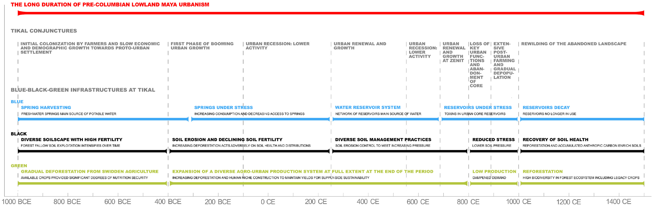
Summary of shifting conjunctures and development of blue-black-green infrastructures at Tikal over the longue durée of pre-Columbian Lowland Maya urbanism (c. 1000 BCE – 1500 CE). Figure by Authors.
The earliest settlement evidence has been unearthed at the building complexes labelled Mundo Perdido and the North Acropolis and in household group 5G-1 (Culbert and Kosakowsky, 2019; Laporte and Valdés, 1993), and it is in these sectors that urban growth is the most evident during the Late Preclassic (400–100 BCE), the first period of booming urban economic and demographic growth. Late Preclassic civic-ceremonial monumental construction at Mundo Perdido and the North Acropolis is extraordinary in artistic and architectural elaboration and scale, indicating an urbanised stratified society with asymmetric distribution of power and wealth governed by royal elites.
The Terminal Preclassic (100 BCE–250 CE) interrupts the Late Preclassic growth conjuncture. In the central Maya lowlands and beyond a marked decrease in monumental construction indicates lower economic activity and urban populations (some city centres were partially or completely abandoned). The evidence at Tikal confirms this pattern: there were no public building construction initiatives, maintenance and refurbishment projects were suspended, and major monumental structures fell out of use. Neither Tikal’s urban core nor the surrounding agro-urban landscape were abandoned, however, and after about three centuries, it rebounded from urban recession (Scarborough and Burnside, 2010).
In the Early Classic (250–550 CE), extensive urban renewal programmes in the city’s core and growth of the supporting agro-urban landscape transformed Tikal into the capital of one of the most powerful Classic Maya city-states. In the city centre, the main seat of power shifted to the so-called Central Plaza (Buttles et al., 2011), but the civic-ceremonial structures that had been abandoned during the Terminal Preclassic were incorporated into the urban core’s reconfigured settlement design. Refurbished and elaborated, the visibility of pyramid temples increased across the city’s expanding agro-urban landscape. Quadrangular plazas and associated temples formed key components in Tikal’s spatial morphology as places for large-scale public political-religious gatherings. Iconography and epigraphy on stelae, altars, and tombs communicated an official political–discourse that, through costly signalling, legitimised the power of royal dynasties.
After 300 years of urban growth, the Middle Classic (550–690 CE) is characterised by a c. 150-years halt in monumental construction activity. This ‘Middle Classic Hiatus’ indicates relatively low economic activity, political turbulence, and dynastic discontinuity among royal elites, trends common to the central lowlands in general, but the most evident at Tikal (Aimers and Iannone, 2014).
Tikal recovered from economic and political recession by the transition into the Late Classic Period (690–800 CE) that would prove to become the apogee of Classic Maya urbanism: cities expanded, new powerful city-states emerged, and political connectivity, interdependence, and competition increased. Tikal’s population grew rapidly, as indicated by intensified construction activity, remodelling and elaboration of existing structures, and the expansion of agro-urban settlement. Furthermore, urban renewal during this conjuncture reconfigured earlier patterns of public movement in the city’s core: plazas that previously had functioned as public ceremonial spaces were transformed into elite residential compounds.
The Terminal Classic (800–1000 CE) was a period of widespread systemic transformation in the central Maya lowlands, a conjuncture initially characterised by dramatic political, economic, and demographic changes referred to as the ‘Classic Maya Collapse’ that involved a series of mutually reinforcing factors and crises events, including economic competition and warfare among power centres, multiyear droughts, and failure of revenue streams (cf., Aimers, 2007). At Tikal, intense urban renewal activity in the city’s centre during the Late Classic came to a halt in the early 9th century and by around 890 CE the urban core had been abandoned. Although Tikal’s centralising urban functions and services had ceased to operate (cf. Smith et al., 2016), the landscape was not yet completely depopulated; some farmers continued to live and work their fields in the shadow of the decaying city centre for at least four generations, only gradually abandoning the land (Grazioso and Scarborough, 2013). With no significant subsequent reoccupation, Tikal urban history ended about a millennium ago. After final abandonment, fully 500 years before the Spanish Conquest spawned other boundary conditions than those that had structured pre-Columbian Lowland Maya urbanism, the area was largely ‘rewilded’, building on the landscape legacies of a Neotropical urban past.
Natural resource management at Tikal: The blue-black-green infrastructure nexus of an agro-urban landscape
Within the context of alternating growth–recession conjunctures of Tikal urban history, the following section synthesises the development and capacity of blue-black-green infrastructures to adaptively supply degrees of food and water security among the city’s householders (Figure 1).
Blue infrastructure: Safeguarding water access
Water availability in the Maya lowlands largely depends on how two characteristics of the hydrological system play out: (1) a seasonally dry and hurricane-prone tropical/sub-tropical climate and (2) a dominantly karst landscape. How these conditions interacted generated opportunities and constraints influencing the emergence of different kinds of blue infrastructure for year-round access to enough water. At Tikal, the eroded and permeable karst limestone bedrock largely prevented major perennial streams from establishing, but also resulted in a shallow and pitted topography that tends to drain runoff to the underground aquifer which lies about 200 m below the ground surface. Through karst solution processes, sinks form in the bedrock that, when lined by naturally infilling clays, will hold water for extended periods. Over time, continuous sedimentation created extensive wetland depressions (bajos), landforms that Middle Preclassic populations encountered when settling in the area. Indeed, one of the lowlands’ largest bajos (Bajo de Santa Fé) flanks the margins of central Tikal (Dunning et al., 2002). However, because bajos tend to dry-out seasonally and the water they hold is typically unpotable, they are inadequate for water harvesting.
The landscape at Tikal is subject to highly seasonal drought-like conditions, with c. 90% of the mean annual rainfall of about 1800 mm in May–December, but with high interannual variability (Dunning et al., 2015; Medina-Elizalde et al., 2010; Figure 1). Palaeoclimatic proxy records indicate significant rainfall variation before, during, and after Tikal’s urban period. Rain-fed agriculture is vulnerable to multiannual drought events, which affected the central lowlands during both the Terminal Preclassic and the Terminal Classic recession conjunctures (Douglas et al., 2015; Dunning et al., 2012, 2014; Kennett et al., 2012; Wahl et al., 2014).
Locational factors for Tikal were likely several, including the presence of elevated ridgetop freshwater springs in the area that would become the city centre. These springs were recharged by seasonal rainfall across unaltered porous limestone surfaces. Estimates suggest that headwater spring activity provided year-round water security for populations residing in this section of the burgeoning city into the early Late Preclassic (Scarborough and Grazioso, 2015). Late Preclassic urban growth changed that. Increasing population numbers required greater volumes of water, and so did the production of plaster that was thickly applied to the monumental building complexes under construction in the booming city centre. Plastered surfaces covering ever larger sections of urban space restricted spring water access and their ability to recharge. Hence, urban development weakened the spring system’s capacity to meet supply-side sustainability as demands grew and disrupted non-declining throughput.
From the Early Classic onwards, the water management system was based on a network of at least 13 large reservoirs within a radius of 1.5 km from the city centre that directed runoff from the deliberately canted and elevated impervious plaza surfaces into seasonally recharged reservoirs (Scarborough et al., 2012). The system had several components, but the cornerstone was a series of large ridgetop reservoirs, reservoirs at the margins of bajos, and small residential reservoirs, several linked together and associated with a cofferdam, filtering, and canal systems (Scarborough and Grazioso, 2015). Because excavations for reservoir construction also generated building material for monumental architecture, the Classic reservoir system co-developed with expanding urban construction. A series of canals, check-dams, and water filtering devices were designed to slow and direct the seasonal flow of precipitation off the plastered surfaces of building complexes and plazas located on hillocks and ridges (Scarborough et al., 2012; Scarborough and Grazioso, 2015; Tankersley et al., 2020). Fully engineered in the Late Classic and likely controlled by Tikal’s rulers, the system defines a convex micro-watershed of gravity-controlled water distribution descending from the central summit of the city and servicing the immediate agro-urban landscape with a potable, rechargeable, and accessible source for household consumption and, possibly, crop irrigation (Lentz et al., 2014, 2018; Scarborough and Burnside, 2010; Scarborough and Grazioso, 2015). Irrigation would have helped to address vulnerability to rainfall seasonality but provided little help against multiyear drought events. Notably, the progressive removal of forest cover during the Late Preclassic and Late Classic growth conjunctures likely exacerbated declining rainfall (Cook et al., 2012; Griffin et al., 2014).
Evidence of high levels of mercury, probably from cinnabar pigments leaking from tombs and washing off palaces and temples, as well as repeated episodes of blue-green algal blooms of toxic cyanobacteria in central reservoirs indicate that water quality, at least in the urban core, was severely compromised during the Late and Terminal Classic Periods (the mercury level in the Late Classic Palace Reservoir exceeded the Toxic Effect Threshold by 14 times; Lentz et al., 2020). Mercury toxicity would not only have had public health implications but – because symptoms of poisoning may have affected the ruling elite’s ability to make good decisions – plausibly had major political ramifications by undermining the credibility of their rule. Algal blooms probably co-occurred with periods of drought conditions in the 9th century when low water levels would have made it difficult to clean contaminated reservoirs. By colouring the water green, the cyanobacteria contamination would have been more obvious to the public and probably had a more immediate impact than the mercury. Two of the cyanobacteria identified that caused the blooms, Microcystis and Planktothrix, produce deadly microcystins, toxins that are not heat labile so the water in the reservoirs could not have been safely consumed even if it was boiled. Outside of the ceremonial urban core, however, reservoirs seem to have avoided the mercury and cyanobacteria problems and likely remained functional sources of clean, uncoloured water throughout the Late Classic (Tankersley et al., 2020). Nevertheless, with the abandonment of Tikal’s city centre in the 9th century, the entire reservoir system fell into decay.
Because the fundamental input (replenishment by precipitation) is an uncontrollable and highly variable factor, assessing non-declining throughput of this rain-fed reservoir system makes little sense. It is more productive to consider its ability to provide supply-side sustainability equitably, integrating additional factors that management institutions, to different degrees, could influence: (1) the surface uptake area of rainwater collection, (2) storage volumetric capacity, (3) control of supply seepage and evaporation, (4) equal distribution among households, and (5) consumption patterns. The increasing scale of the system over time suggests that collection and storage capacity was continuously improved to meet increasing demands during growth conjunctures. However, this centralised system seems not to have been designed to distribute water throughout Tikal’s entire agro-urban landscape. Furthermore, to construct, expand, and maintain the efficacy of the system required large amounts of water in plaster production. There were, thus, not only high investment costs in initiating and elaborating the system, but also in maintaining it, including identifying and addressing issues of contamination. Terminal Classic water contamination suggests that the system’s dependence on maintenance was poorly adapted to provide potable water in a post-urban context.
Black infrastructure: Maintaining stocks of healthy soils
The inhabitants of Tikal devised a dynamic agrosystem grounded in the nuances of the local and regional soilscape and its changes that co-evolved with urban development. Black infrastructure references the prevailing colour of the topsoil, reflective of high organic content and fertility. In the agro-urban landscape, productive soils were incorporated into the urban fabric in household gardens, infields, orchards, hinterland farms, and managed forests that contributed food, fuel, fibre, medicinal plants, and timber (Dunning et al., 2020; Evans et al., 2021; Lentz et al., 2014; Morell-Hart et al., 2023; Scarborough et al., 2012). The sustained health of these soils was of critical importance to the vitality of the urban ecosystem and its inhabitants (Beach et al., 2019; Evans et al., 2021).
The soilscape Middle Preclassic farmers encountered formed a mosaic that presented both opportunities and constraints to cultivation and that, over the following centuries, would change in response to anthropogenic drivers. Three types of soil dominate: (1) shallow soils on sloping uplands, ranging from deeper Rendolls to skeletal Entisols; (2) deeper cumulic Rendolls along slope breaks at the margins of karst depressions; and (3) deep Vertisols found across the floors of karst depressions (for a comprehensive overview of soil terminology, see Buol et al., 2011). Smaller patches of Histosols also occur in areas with perennial moisture. The characteristics that differentiate the soils around Tikal largely depend on topographic position and parent material. Natural soil formation is slow since the parent limestone is almost pure calcium carbonate and produces little nutritive residuum as it weathers. Instead, most mineral matter stems from Aeolian (wind-blown) Saharan silt and volcanic ash carried north from sporadic eruptions in the highlands of southern Mexico, Guatemala, and El Salvador (Bautista et al., 2011; Tankersley et al., 2016). Hence, available phosphorous – the major soil nutrient in shortest supply – derives mostly from Aeolian dust and local organic matter recycled by natural processes and from human behaviour, including both unintentional deposition and active soil management. These general characteristics determined several fundamental challenges to both sustainable soil management and to supply-side sustainability as the city grew.
Although soil cover develops on forested uplands in Tikal’s topographic mosaic, much of the Aeolian fraction is carried into local depressions over time, quickly weathering into a suite of Vertisols. High clay content provides some resistance to erosion, but thin soils on slopes in a climate with intense tropical rainstorms are vulnerable to rapid removal once vegetation is removed. Evidence for heavy soil loss during the Late Preclassic, when deforestation began in earnest, is widespread (Dunning et al., 2019). Because forests act as sieves that capture and retain Aeolian particles, deforestation decreases soil enrichment (Dunning et al., 2012) and contributes to a decline in soil fertility and throughput, potentially stressing supply-side sustainability. As cropping intensified in response to population growth, forest fallowing opportunities dropped and soil organic matter renewal diminished. Applying green manure, compost, human waste, and wetland muck may have compensated for the loss of Aeolian-derived minerals, but the evidence for widely practised soil improvement remains elusive. Hence, the Late Preclassic growth conjuncture is associated with land management practices that decreased the stock of healthy soils, potentially disrupting non-declining throughput of soil resources and undermining supply-side sustainability (Dunning et al., 2012; Turner and Sabloff, 2012).
To offset soil migration, landesque capital investments were made to increase land productivity throughout the Classic, for example by trapping soil for agriculture in piedmont stone terraces, particularly around the margins of bajos close to the urban core (Dunning et al., 2015, 2019; Fedick et al., 2023). In general, however, agricultural stone terraces are relatively sparse at Tikal (Dunning et al., 2019; Murtha, 2015), suggesting that the stabilising of upland slopes was achieved by continuous vegetative cover or constructing berms of soil and/or vegetation (Dunning et al., 2019; Lentz et al., 2014). Tikal farmers probably employed ridge and furrow agricultural techniques (Sheets et al., 2012) among other strategies to control soil erosion. Because Late Classic reservoir sedimentation rates were low (and mostly Aeolian) (Lentz et al., 2015), topsoil erosion control appears to have become increasingly efficient during Tikal’s terminal growth conjuncture.
Eroded upland soils were typically redeposited at local slope breaks within seasonal stream channels or along the margins of bajos. With soil distribution fragmenting in the agro-urban landscape, soils accumulating at these locations increasingly became foci for agricultural intensification over time (Balzotti et al., 2013; Dunning et al., 2019). Combined with a thick layer of colluvial overburden deposited by downslope transport, these developed into extremely productive soils for urban agriculture. Hence, large-scale erosion and soil movement owing to Late Preclassic deforestation transformed the city’s black infrastructure by redistributing production potential to other locations, enhancing the capacity of enriched soils to support non-declining throughput during later periods.
Areas of soil moisture control to enhance drainage have been identified around some bajo perimeters (Garrison et al., 2019), but the bajos’ Vertisols (hard in the dry season and impermeable in the wet) pose problems for agriculture. Evidence for wetland ditching to expand Tikal’s black infrastructure is currently limited, but recent LiDAR-mapping (airborne laser scanning) indicates some ditching yet to be verified in the field (Canuto et al., 2018).
Finally, the supply-side sustainability of Tikal’s black infrastructure was constrained by the city’s population growth and by regional political and economic dynamics. As Tikal grew, so did most of its competing city-state neighbours. In the 8th century CE, Tikal was well into a growth conjuncture but had nowhere to expand except through the subjugation of rivalling cities. All available farmland was in use, except for land intentionally preserved as forest (cf. Canuto et al., 2018). At this point, Tikal was essentially locked in a zero-sum game of its soil resources trying to balance the prodigious need to produce enough food and the need for wood (especially for fuel) (Lentz et al., 2014) in an agro-urban soilscape transformed by past landscaping and in competition with other urban land use needs.
Green infrastructure: Plant management
Agriculture at Tikal was a dynamic undertaking that co-evolved in scope and complexity with urban development. During the growth conjuncture of the Late Preclassic, extensive agricultural activities coupled with widespread deforestation led to environmental changes that, in some respects, encouraged both conservation practices and agricultural intensification in later periods. Pollen data (Hodell et al., 2000; Islebe et al., 1996) suggest widespread deforestation shortly after initial settlement at Tikal by swidden agriculturalists and forest gardeners managing a mosaic of plots in cultivation and fallow with a diverse set of harvestable resources during the Middle Preclassic (Ford and Nigh, 2015). Paleoethnobotanical studies reveal evidence for several cultigens, including two seed crops, scarlet runner bean (Phaseolus coccineus L.) and maize (Zea mays L.); two root crops, sweet potato (Ipomoea batatas [L.] Lam.) and achira (Canna indica L.); and two tree crops, coyol (Acrocomia aculeata [Jacq.] Lodd. ex Mart.) and jocote (Spondias purpurea L.) (Lentz et al., 2014, 2015), suggesting significant degrees of nutrition security.
As populations grew, the agrosystem expanded and intensified gradually to extend the scope of human niche construction (Lentz et al., 2014, 2015). The approximate extractive zone of Late Preclassic Tikal included 256 km2 of upland forest and 40 km2 of bajo forest. During the Late Classic growth conjuncture this zone expanded to include 1100 km2 of mostly upland habitats as sources of food, fibre, fuel, and construction material. The land available in the Late Classic was approximately 3.7 times that of the Late Preclassic, and the population of Late Classic Tikal greatly increased and possibly quadrupled (Culbert and Rice, 1990). Thus, although Late Classic occupants had more land to meet their extractive needs, they also had more mouths to feed and more houses to construct. As a result, increasing demands pressured green infrastructures to provide, yet at the same time required conservative practices to maintain productivity and yields.
During the Classic Periods, major crops included three bean species (Phaseolus spp.), two squash species (Cucurbita spp.), maize, cotton (Gossypium hirsutum L.), and several root crop species, viz., malanga (Xanthosoma sagittifolium (L.) Schott), sweet potato, achira, and undoubtedly manioc (Manihot esculenta Crantz) (Lentz et al., 2014; Morell-Hart et al., 2023). In addition, several tree crops were cultivated, including coyol (Acrocomia aculeata (Jacq.) Lodd. ex R.Keith), cocoyol (Bactris major Jacq.), nance (Byrsonima crassifolia [L.] Kunth), avocado (Persea americana Mill.), zapote (Pouteria sapota (Jacq.) H.E.Moore & Stearn), jocote, and cacao (Theobroma cacao L.) (Lentz et al., 2015). With these crops and the intensive agricultural techniques employed, the Tikal agro-urban landscape was largely able to provide supply-side sustainability of both basic food crops and wood production to large populations. In the Late Classic, pollen and settlement data (Fry, 2003; Hodell et al., 2000; Islebe et al., 1996) indicate that approximately 350 km2 was covered by carefully managed upland forest, 165 km2 consisted of widely spaced urban farmsteads with household gardens and orchards, and 350 km2 was committed to extensive short-fallow cycle agriculture. In addition, the bajos were important agricultural zones, especially during the booming Late Classic. More than 80 km2 (approximately 30%) of bajo forests may have been removed for the cultivation of achira, maize, and other crops. The remaining portion of bajo forests formed an essential component of the city’s green infrastructure and was used for forest product extraction on a broad scale, particularly for timber, fruits, medicine, and fibre (Dunning et al., 2015; Lentz and Hockaday, 2009). Recent eDNA analyses (Lentz et al., 2021) indicate that small trees, shrubs, and other perennials were maintained around reservoirs to prevent erosion, stabilise embankments, and create a park-like green space in an urban core that was otherwise largely covered by plastered surfaces.
Concluding discussion: Urban sustainability and temporal scaling
Over the last decade differentiated views of pathways towards sustainability transitions have developed, variously emphasising dimensions such as reorientation of sustainable trajectories and emergent transformation substitution (Geels and Schot, 2010), as well as transformation, reconfiguration, and de-coupling and re-alignment (de Haan and Rotmans, 2011). These patterns and types of transitions are dynamic and uncertain, and they may combine in varying ways to diverge from intended pathways. Lacking among all approaches, however, is any attention to project pathways that extend beyond several decades. At a time when climate change, biodiversity loss, and other tipping points are on a trajectory that may flip the Earth system unless drivers of change are immediately mitigated (IPCC, 2023), this is a considerable oversight – methods, techniques, and creative approaches are urgently required to better understand and plan for the contingencies of profound global change. It is possible, perhaps likely, that the change ahead is of such unprecedented post-Pleistocene character and scale that it is more appropriate to anticipate boundary conditions shifting towards a different structuring longue durée for global urban development than ‘merely’ fluctuating conjunctures. In projecting possible urban futures, this is a type of reflection our multiscalar temporal framework of analysis encourages.
If, as we suggest, it is beyond the scope of Tikal as an individual city to define the longue durée, it is productive to trace how a city manages urban functions over shorter timescales within and, when relevant, across boundary conditions. We have focussed on characterising the main phases of urban development within the long duration of pre-Columbian Lowland Maya urbanism. There is little doubt that continuous occupation from aggregating village origins in the Middle Preclassic developing into a premodern city in the Late Preclassic that maintained urban functions and structure over about 1500 years demonstrates considerable settlement persistence by any comparative measure (Smith et al., 2021). Although longevity of urban settlement may suggest sustainability and stress-resilience, superficial deductions are a poor basis to generate expedient insight for either theoretical explanation or practical application. Outlining Tikal’s history as a series of conjunctures (Figure 1), we have shown that urban development was non-linear, oscillated between phases of growth and recession, and that the pace of change tended to accelerate as the scale and complexity of the urban system increased. Reviewing the development of blue-black-green infrastructures as basic inputs for urban metabolism we have summarised how these transformed over time relative to overall urban development. A principal insight for the projection of urban sustainability transitions is highlighting temporal scaling and multiple temporalities as fundamentals for any assessment of urban sustainability. Examining the often-confounding sustainability of Tikal and its blue-black-green infrastructures at the temporal scale of conjunctures, a pattern of co-construction among innovation, institutions, and users emerges, highlighting their relational complexities. No infrastructure was an epi-causal determinant of either unsustainability or sustainability, but party to processes of feedbacks and influence within a complex socio-ecological system, co-creating urban transition pathways.
The relational complexities between blue-black-green infrastructures and the urban system at large illustrate broad patterns of both correspondence and non-correspondence over 1500 years of shifting urban conjunctures. Among these infrastructures, the blue involved the highest investment in terms of both start-up costs and maintenance but is arguably the most unstable with its sharp decline in function during the Terminal Classic. Black infrastructure was more durable, although urban landscape engineering (deforestation, covering grey infrastructure, landesque investments, agriculture, waste disposal) reworked and redistributed soil cover. Hence, today’s soil mosaic includes anthropic soils with high soil nutrient and organic contents, a legacy effect in today’s forest landscape ecology of an urban past’s black infrastructure. Partly dependent on blue and black infrastructure, the green infrastructure for plant harvesting was highly varied across time and space and tied more closely to local institutions. These intertwined systems were closely related to the success and sustainability of the city and provide specific insights in to Tikal as an urban system. Attention to urban infrastructures and their developmental paths demonstrates that urban sustainable transformations require radical cross-cutting changes to dominant infrastructures, their governance and regulation, cultures and values, and associated practices.
Because Tikal lost its urban functions and structure in the 9th century CE – over half a millennium before European contact transformed the boundary conditions for pre-Columbian Lowland Maya urbanism – it is deceptively straightforward to assert that the city was not sustainable over the longue durée. However, regional synchronous political fragmentation and the magnitude of urban dysfunction of most other cities in the central Maya lowlands during the Terminal Classic suggest that Tikal’s capacity to persist did not simply depend on the internal metabolic support system’s ability to consistently deliver supply-side sustainability at some minimum level of requirement but was conditioned by external connectivity and interdependencies with the larger regional socio-ecological system. The collapse included elements of organisational complexity-loss, urban downscaling, and economic recession at numerous central Maya lowland cities. Although unintentional, disruptive to the social fabric of agro-urban lifeways, and involving much human suffering, these systemic changes were initially a breakdown of society’s elite segments that in some respects benefitted the population at large – because systems to extort labour and material revenues ceased – and likely contributed to greater relative equity. Tikal’s agro-urban landscape morphed into an agrarian one as a significant farming population lingered for at least a century, a continuation of occupation that mapped onto the landscape legacies of an urban past. The loss of centralised urban functions and services, however, had negative consequences for the functioning of the investment-heavy blue infrastructure once maintenance failed, and most likely contributed to population abandonment by the end of the 10th century. Arguably, the capacity of Tikal’s infrastructures to foster basic urban metabolism largely independently, and the city yet being unable to navigate larger-scale challenges, is contradictory. It suggests, on the one hand, that a city’s agency is a potent principal engineer of its own sustainability transformations, but, on the other, that factors playing out over larger spatial scales – today the wicked problems of global warming, biodiversity loss, food insecurity, and socio-economic inequalities – are processes that cities as autonomous actors are unable to address in isolation. This conundrum provides long-term insight and guidance today. Contemporary cities must consider sustainable transitions in, of, and by cities as a structuring and framing approach. As Hölscher and Frantzeskaki (2021) note, more research into how resources and opportunities are distributed and made accessible across different cities (e.g. ‘global’ cities, metropolitan cities, and cities in the Global South) is essential for making urban landscapes sustainable.
The share of the global population living in cities has increased dramatically but necessary attention to urban infrastructures has not followed suit. The blue-black-green infrastructures sponsoring urban and peri-urban agriculture (UPA) to provide supply-side sustainability remain particularly peripheral to global considerations of urban sustainability (Hawken et al., 2021) in both Agenda 2030 and the NUA, despite earlier calls that draw on alternative and past urban traditions to highlight the potential of UPA to contribute to urban resilience (Barthel and Isendahl, 2013; Simon and Adam-Bradford, 2016). Our multitemporal analysis of Tikal urban history demonstrates the benefits of a closer and integral consideration of blue-green-black infrastructures for urban areas globally. There are fundamental implications of this study for the NUA and related discourses that we recommend are adopted as guidelines for any explicit or implicit formulation of long-term vision in adaptive urban planning and design:
Detail the longevity of relative temporal terms (e.g. in decades, generations, centuries, millennia, or another relevant timescale).
Assess options to further extend the chosen temporal framework and note what factors limit the potential for predictions over more prolonged temporal scales.
Consider that complementary and linked blue-black-green infrastructures require consideration in relation to distinct and differing timeframes and conjunctures.
Review the boundary conditions of applied temporal frameworks and assess under what scenarios (e.g. overshooting climate targets) changing boundary conditions will undermine the strength of proposed visions or make them obsolete.
These suggestions are also relevant for archaeological approaches examining the sustainability of past urban systems. Our and similar analyses of sustainability’s different dimensions in past urban traditions (e.g. Klassen et al., 2022) contribute new insights on the challenges associated with future transitions to sustainable urban socio-ecological systems and safeguarding those functions and behaviours over varying temporal scales. The remarkable diversity of past and present urban systems and infrastructural initiatives cannot be fitted within a single narrative of urban sustainability, however, and further case study-focussed and comparative research is required to examine how blue-black-green infrastructures can support complex transformative change of aggregated human population zones struggling with potable water scarcity, soil degradation, and habitat and biodiversity loss.
Footnotes
Acknowledgements
We are grateful for three anonymous peer reviewers’ instructive comments.
Declaration of conflicting interests
The author(s) declared no potential conflicts of interest with respect to the research, authorship, and/or publication of this article.
Funding
The author(s) disclosed receipt of the following financial support for the research, authorship, and/or publication of this article: Research at Tikal was supported by grants from the Alphawood Foundation (awarded to Scarborough), the U.S. National Science Foundation (BCS-0810118 and BCS-1642547 awarded to Lentz, Dunning, and Scarborough), the Wenner-Gren Foundation (7799 awarded to Lentz, Dunning, and Scarborough), and the University of Cincinnati.