
Abstract
This study adopts a spatial perspective to analyse the complex commuting patterns of the Beijing metropolitan region. By combining measures of the built environment, neighbourhood characteristics and development time periods, a four-fold neighbourhood classification was derived by cluster analysis to reflect different urbanisation contexts. Commuting flows were mapped to illustrate the spatial mismatch of home–work locations during the rampant urbanisation process. The novel use of a multilevel modelling approach shows how individual socio-economic attributes and neighbourhood factors, and their interactive effects, explain the varied commuting patterns. The cross-level interactions of variables highlight the predominant influence of individual attributes, which also interact with locational conditions of neighbourhood with differential explanatory power, on commuting patterns.
Introduction
With the unprecedented pace of urbanisation and economic growth in China over the last three decades, new and varied relationships between home and work locations, and a concomitant decline in job accessibility and a rapid increase in commuting time, are found in its megacities (Ta et al., 2017; Zhao et al., 2011). The publication of the ‘National New Urbanisation Plan’ (NUP) in 2014 signals the Chinese state’s determination to coordinate and manage urbanisation towards a more environmentally sustainable approach. Given the government’s central role in urbanisation planning and land use restructuring, there is a need to understand how urban expansion has shaped housing and employment locations that result in diverse commuting patterns under different spatial and temporal urbanisation contexts shaped by the intertwining of government policies and market forces.
When Beijing was designed as the national capital, it was a rather compact city featuring the danwei (work unit) system with planned co-location of work and residence. Early housing reform in the 1980s focused on the privatisation of danwei houses through sales to sitting tenants at discount prices, and state-owned institutions were discouraged from housing construction (Wang and Chai, 2009). Instead, development companies were established to develop large housing estates and the housing responsibility of danwei reduced after the 1998 housing reforms (Wang and Li, 2004). Local government, incentivised by economic and political interests, became increasingly entrepreneurial by forming ‘growth coalitions’ with developers to transform state-organised collective spaces into commodified urban spaces (Wu, 2005). During this process, house price has become the main allocative mechanism of the population into homogenised residential segments. While leasing land for residential and commercial uses has constituted an essential source of extra-budgetary income for local government, it is the opposite for industrial uses. Local government has offered heavily discounted land prices to attract foreign industrial investment, usually through direct negotiation 1 rather than land auctions in the open market (Cao et al., 2008; Tao et al., 2010).
Since the late 1990s, with the deepening of market-oriented reforms, urban growth in suburban Beijing has given way to a large amount of new commercial housing (Yang et al., 2018). The transfer of ‘granted land-use rights’ from local government to developers for revenue generation and economic growth has resulted in scattered and even illegal developments (Zhao, 2010). Between 1985 and 2010, around 23.4% of urban growth occurred in rural settlements and 57.1% on arable land (Liu et al., 2017). The rampant growth included formal commercial housing through the legal appropriation of rural land and informal housing developments initiated by local villagers without legal approval (such as ‘small property housing’ and illegal housing in ‘urban villages’). Economic and affordable housing was proposed towards the end of the 1990s to meet the demand of lower-income households. Starting from the 4th ring road to the 5th ring road in the north, several huge affordable housing neighbourhoods such as Huilongguan and Tiantongyuan were developed. Between 2001 and 2012, residential land use showed the greatest expansion (especially in the north and the east), followed by industrial and commercial land (Jiang et al., 2016).
Economic development and sweeping institutional reforms of land and housing markets, facilitated by urban master planning, have become the de facto drivers in re-shaping home–work spatial relations in Beijing (Qin and Han, 2013). Planning in the pre-reform era focused on the regeneration of the historical core for administrative and residential use and the development of its industrial base. Since the 1983 Master Plan, concerted effort has been made to promote a polycentric urban form. The Beijing Urban Master Plan (1991–2010) aimed to relocate all manufacturing factories from the central city to industrial satellite towns in suburban counties by imposing strict controls on industrial land expansion within the 3rd ring road and only allowing vacated factory sites for public facility, office and residential uses. A polycentric structure, with ‘two-axes-two-belts and multiple functional centres’, was also highlighted in the Beijing Master Plan (2004–2020). However, both population and land use growth rates rapidly outpaced the 20-year planned period and the population targets in the 1991 and 2004 Master Plans (Wong et al., 2018a). Furthermore, according to the 2010 Population Census, the six central urban districts account for 60% of Beijing’s population and 66% of its GDP. Thus, both Master Plans failed to transform Beijing’s spatial structure from a monocentric to a polycentric one.
A key thread running through Beijing’s spatial decentralisation has been strategic investment in transport infrastructure to connect the designated ‘decentralisation sites’. For instance, Beijing’s 4th and 5th ring roads were built to connect the ten ‘dispersed clusters’, as planned in the 1991 Master Plan; and four new metro lines were built to connect new towns such as Changping, Daxing, Fangshan and Yizhuang, as in the 2004 Master Plan. Nonetheless, most employment centres in Beijing are located between the 2nd and the 4th ring roads. While residential real estate expands rapidly into the suburbs, the ongoing industrial clustering in central urban districts, especially the high-tech and service industries in Haidian and Chaoyang districts, has exacerbated the problem of long-distance commuting. Despite major investment in public transport, the number of private vehicles increased from 7000 to 4.4 million between 1987 and 2015 (BMBS, 2017).
Given the dramatic urban expansion of residential use and serious congestion problems, the Beijing metropolitan region (BMR) provides an ideal spatial context to explore commuting patterns and urbanisation issues at the neighbourhood level. The next section reviews key commuting literature to establish the research gaps and research questions to be addressed. The following section explains the research methodology of data collection, neighbourhood classification and modelling approaches. The next two sections present the commuting flow mapping analysis and the multilevel modelling findings. Before concluding, the penultimate section discusses the spatial effect of different neighbourhood types and their interactive effects with personal characteristics on commuting patterns and draws out their implications for urban planning.
The relationship of home–work locations
The logistical relationship between the housing market and the labour market varies spatially and temporally (Hincks and Wong, 2010). Their dynamic interactions, via individuals’ residential and employment location choices, are shaped by the spatial structure of cities and regions; but the resulting commuting patterns in turn trigger further spatial development through planning and transport measures (Anas et al., 1998). The classic monocentric model assumes that travel behaviour is based on the trade-off between housing and transport costs and accessibility to the city centre where jobs concentrate (Alonso, 1964). With rapid suburbanisation, a monocentric urban form is associated with traffic congestion and excess commuting. Suburban neighbourhoods, especially in the USA, are often found to be domicile hinterlands and the relocation of urban centre functions to suburban nodes can lead to commuting mode switches to private cars (Schwanen et al., 2001). A polycentric (intra-urban) spatial structure is, however, regarded as more sustainable with the potential to reduce suburb-to-centre commuting trips and distances (Ewing, 1997). This lends support to the co-location argument that employment should follow the population in decentralising to suburban areas (Maat et al., 2005). Nonetheless, this has been found to be difficult to implement, as commuters tend to triangulate home, work and out-of-home activities to maximise their overall utility (Breheny, 1999). Research evidence also suggests that economic growth continues to drive residential development outwards, leading to the decline of older suburbs (Bier, 2001) and creating a vicious circle of commuting as the affluent groups move further away from the older suburban work centres (Cervero and Gorham, 1995).
A considerable amount of research focuses on examining commuting patterns, especially their relationship with personal attributes and urban form. Personal socio-economic characteristics such as age, education, gender, car ownership, driving licence, work status, employment type, attitudes and preferences are found to be associated with commuting patterns (e.g. Cristaldi, 2005; Lin et al., 2017). Urban forms, often measured by density, geometric shape, land use and infrastructure (e.g. Melo et al., 2011; Nasri and Zhang, 2019; Schwanen et al., 2001) are also found to be linked to commuting patterns, and such relationships persist after socio-economic attributes are controlled (e.g. Kitamura et al., 1997). Literature on commuting has been largely based on Western experience, but China’s urban context is significantly different in terms of its spatial organisation of settlements, city size and density, spatial planning, and culturally rooted norms and values. Research on commuting in China’s megacities has so far focused on examining the intrinsic nature of commutes (Ta et al., 2017; Wang and Chai, 2009), the commuting patterns of different socio-economic groups (Zhou et al., 2014), the relationship between built environment characteristics and commuting behaviour (Hu et al., 2018; Zhao et al., 2011), and the job–housing relationship via big data analytics (Zhou et al., 2018). By studying 164 cities in China, Sun et al. (2016) conclude that the average commute duration is positively correlated with city size and jobs–housing separation but is negatively correlated with density and polycentricity. Other studies at the city level suggest that longer commuting times are associated with job–housing imbalance, improved transport accessibility and low land-use density at the city fringe (Zhao et al., 2011). High-income workers are found to be willing to make longer commutes to satisfy their residential preferences, while low- and mid-income workers are forced to reside away from job centres with high housing prices (Zhao et al., 2011). Planned subcentres in suburban areas are found to reduce long-distance commuting, especially for those employed in the manufacturing sector. Historical factors also influence commuting patterns; for example, commuters living in danwei housing have shorter commuting trips and higher use of non-motorised transport modes than those living in other housing types (Ta et al., 2017; Wang and Zhou, 2017).
Notwithstanding the large number of commuting studies, the above review identifies some significant research gaps. Since most studies focus on statistical modelling, the conceptualisation of ‘suburbs’, ‘sprawl’ and ‘urban expansion’ has been criticised as over-simplistic and lacking in contextualisation (Talen, 2003). The urban expansion process of cities in China is very much related to its planning policies and contexts (Wei, 2012), but the linkage between commuting patterns, urbanisation processes and planning policy have not been fully established. Even when the impact of urban growth on commuting patterns is examined (Li, 2010; Zhao and Howden-Chapman, 2010), urban expansion and spatial transformation tend to be treated as contextual information rather than as variables to quantify their relationship with commuting patterns. The unit of analysis of previous studies tends to be individual commuters; though a few studies emphasise the importance of residential differentiation in explaining commuting patterns, neighbourhood differentiation is simply measured by housing types such as commodity, danwei and social welfare housing. Furthermore, their survey samples were drawn from the urban core, rather than the most expanded outer metropolitan areas. From a planning perspective, a neighbourhood is a spatial unit that builds the physical and social fabric of a city and is a trip-generation unit which is crucial to residents’ quality of life (Rohe, 2009). This study, therefore, aims to adopt a spatial perspective to analyse the commuting dynamics of home–work locations in residential neighbourhoods that have undergone different spatial and temporal urban expansion processes in the BMR. The study does not only include built environment variables but also variables reflecting neighbourhood characteristics and the development process, in the classification of neighbourhoods. While existing research treats all variables, personal and spatial attributes, at the same level to explain commuting patterns, this study applies a multilevel modelling approach to address four key research questions:
What are the commuting patterns and characteristics of commutes in neighbourhoods with different spatial and temporal urbanisation contexts?
Are residents’ commuting patterns related to their socio-economic attributes and neighbourhood characteristics?
Do commuting patterns vary between different neighbourhoods after taking commuters’ socio-economic attributes into account?
What are the interaction effects between individual attributes and neighbourhood characteristics on commuting patterns?
Research methodology
Neighbourhood survey and commuting analysis
Survey data on residents’ demographic characteristics, housing and living environment, transport use and commute were collected in the BMR between May and June 2017 with a structured questionnaire. The participants were chosen on the basis of a multi-stage, spatial cluster sampling approach (Wong et al., 2018b). The analysis focuses on 19 neighbourhoods in six townships that have been subject to major urbanisation pressure over the last three decades. Based on the target sample size of 0.2% of the total residential population of the six townships (i.e. 2084 out of 1,041,854) and a built-in attrition rate of 15%, about 120 survey participants were targeted in each neighbourhood with a non-probability quota sample based on the age and gender distribution of the township. A total of 1286 questionnaire participants were in employment and 917 provided information of their work location. This sample size can be deemed as large when compared with similar studies (e.g. Zhao and Howden-Chapman, 2010; Zhao et al., 2011). Specific questionnaire items related to commuting include: residential and employment location, prime commuting mode and one-way commuting time of a typical working day. Home–work locations extracted from the survey data were used for commuting flow mapping via ArcGIS and deriving commuting distance as the crow flies. By analysing the Third Beijing Economic Census data, the main employment centres (defined as those with 50,000 or more in employment at the township level) were identified to contextualise the mapping analysis.
Neighbourhood classification: Spatial cluster analysis
A two-step clustering method, combining the hierarchical and non-hierarchical methods, was used to classify the 19 surveyed neighbourhoods. Based on seven variables measuring the spatial-urbanisation process and locational characteristics of neighbourhoods, four neighbourhood clusters (inner metropolitan, suburban established, suburban isolated, and transient) were derived (see Table 1). A series of methodological steps, such as correlation analysis, factor analysis and standardisation, were performed to examine the statistical distribution, multicollinearity, underlying dimensions and sensitivity. The final model’s cluster quality is deemed as ‘good’ by the Silhouette measure of cohesion and separation (+0.5 in the scale of −1 to +1).
Neighbourhood type classification: variables and pen pictures.
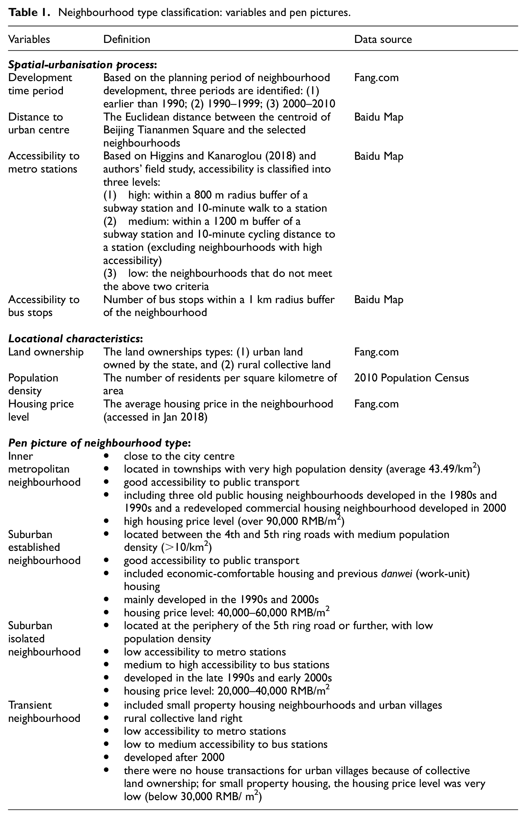
The inner metropolitan and the suburban established neighbourhoods, developed earlier in the urbanisation process, tend to have higher population density, good accessibility to public transport and higher house prices (see Table 1). The suburban isolated and transient neighbourhoods developed later and in less accessible locations and thus command lower house prices. Each neighbourhood type also has a very distinct socio-economic composition (see Table 2). Both the inner metropolitan and the suburban established groups consist of more affluent and educated residents and many residents work in public organisations and other enterprises. On the other hand, the suburban isolated and the transient groups have a larger proportion of low-income and less-educated residents, with the former faring slightly better than the latter. One main characteristic of the transient neighbourhoods is residents’ preoccupation with small businesses. The inner metropolitan group is clearly demarcated from the suburban groups by having a more mature age structure (over one-fifth of residents aged over 54), which reflects the maturity of neighbourhoods in the inner-city location.
Socio-economic and commuting characteristics by neighbourhood type.
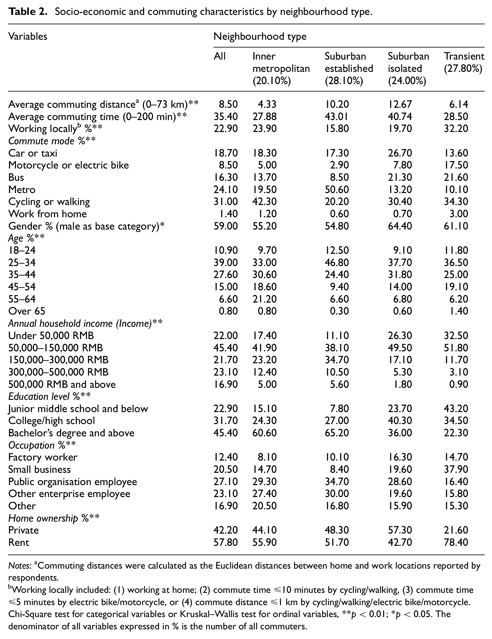
Notes: aCommuting distances were calculated as the Euclidean distances between home and work locations reported by respondents.
Working locally included: (1) working at home; (2) commute time ≤10 minutes by cycling/walking, (3) commute time ≤5 minutes by electric bike/motorcycle, or (4) commute distance ≤1 km by cycling/walking/electric bike/motorcycle.
Chi-Square test for categorical variables or Kruskal–Wallis test for ordinal variables, **p < 0.01; *p < 0.05. The denominator of all variables expressed in % is the number of all commuters.
Statistical testing and multilevel modelling
The relationships between commuting variables (distance, time and mode) and personal attributes as well as neighbourhood types were first examined with appropriate statistical tests (e.g. Kruskal–Wallis test and Chi-square test). The analysis was based on the assumption that residents’ socio-economic attributes, commuting modes (reflecting personal resources and access to transport modes) and neighbourhood types are related to their commuting time and distance. Single-level regression models were then conducted to test the relationship between different independent variables and the dependent variables. A series of statistical tests (e.g. the Durbin–Watson test and Pearson correlation) were applied to exclude insignificant variables (e.g. car ownership, with children) from the models. Residents’ socio-economic attributes (see Table 2), commuting modes and neighbourhood types were tested and applied in the single-level regression models.
More advanced regression models were built through multilevel analysis on the dependent variables of commuting distance and time. Since the data have a two-level structure, with individuals nested hierarchically into neighbourhoods, the multilevel modelling approach was adopted. Those individual-level variables that are statistically significant in the single-level regression model and the four neighbourhood types were included in the multilevel models. Multilevel models can decompose variations of commuting patterns at different levels and provide reliable estimations of between-neighbourhood variations while controlling for individual-level variables (Dang et al., 2019). The two-level regression model is specified as below:
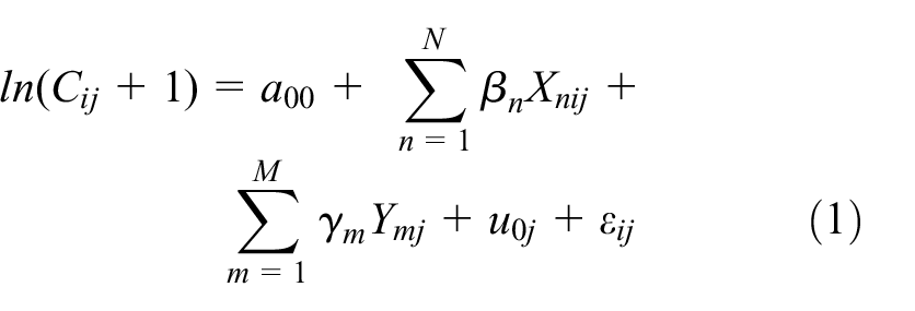
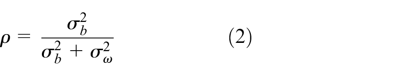
where Cij represents the dependent variables of commuting time or commuting distance and ln(Cij+1) is used to correct the skewed value of the dependent variables for modelling. Xnij and Ymj denote a set of individual-level variables and neighbourhood type variables, respectively, with βn and γm as their respective slopes; a00 is the intercept; u0j represents the between-neighbourhood variation intercept; and εij is the variation within neighbourhoods. Equation (2) calculates the intra-class correlation (ICC, denoted as ρ) showing the proportion of total variance of the dependent variable being explained by the grouping structure. The higher the ICC, the more variations that exist between neighbourhoods, with
Commuting characteristics and commuting flow patterns
The BMR has a single central area and a zonal structure of five concentric ring roads linked by radial expressways. Its built-up area expanded by 2.4 times from 1282 to 3132 km2 and its population rose from 10.9 to 21.7 million between 1990 and 2015 (Beijing Municipal Bureau of Statistics, 2017), with very rapid expansion since the millennium (Figure 1a). The main employment centres are located within the 4th ring road and mainly to the east and the northwest of the urban core (Figure 1b); and only a few, both small and large, are found scattered beyond the 5th and 6th ring roads. Besides the inner metropolitan neighbourhoods, the others are located at/beyond the 5th ring road; which reflects the rapid residential decentralisation process since the 1990s.
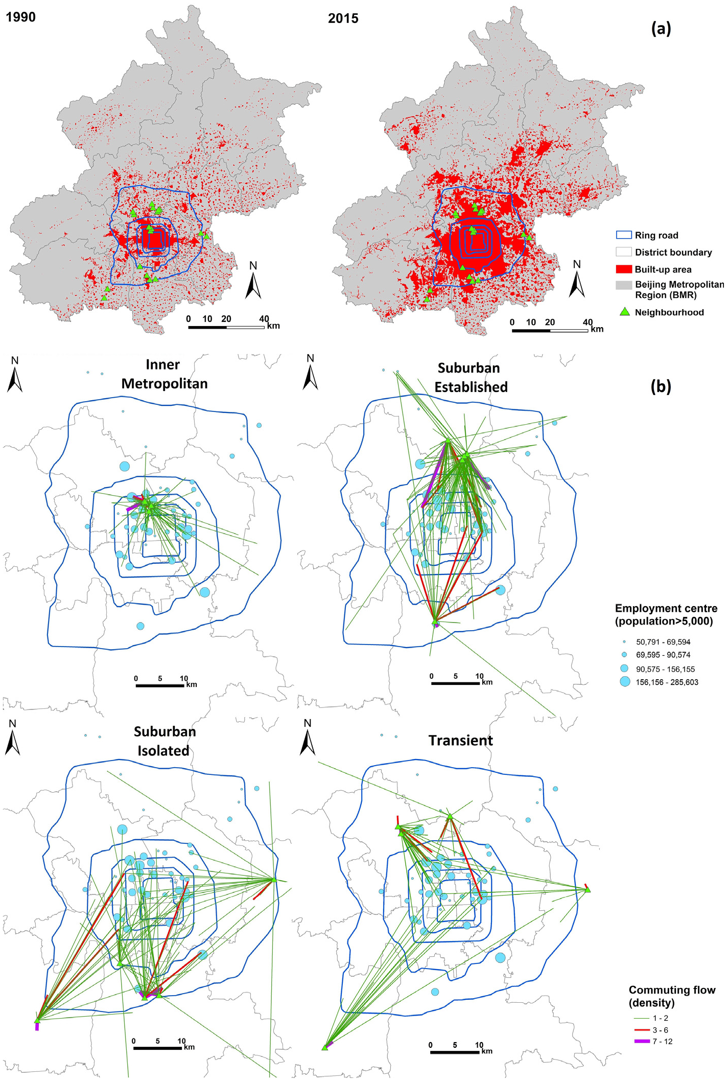
(a) Survey neighbourhoods and urban expansion, 1990–2015; and (b) main employment centres and commuting flows of the four neighbourhood types in the BMR (all administrative districts of Beijing).
The analysis of commuting flow patterns by neighbourhood type in Figure 1b highlights a major spatial mismatch between residential and employment locations in the BMR. Located between the 2nd and the 4th ring roads, residents in the inner metropolitan neighbourhoods have good physical and transport access to the main employment centres. They tend either to work locally (24%) or to commute a short distance (average of 4.3 km), with an average commuting time of just under 28 minutes. They tend to use sustainable commuting modes, with 43% either walking or cycling to work and 34% using public transport such as metro or bus (see Table 2). Nonetheless, some long commuting flows are up to 33 km towards the 5th and 6th ring roads and nearly 19% of residents commute by car or taxi. On the other hand, the majority of commutes in the suburban established neighbourhoods (located outside the 5th ring road and mostly in the northern area) flow towards the urban core, with an average distance of 10.2 km and a commuting time of 43 minutes. The level of self-containment in this group is lower than in the inner metropolitan group, as only 15.8% of residents work locally. There are also some very long-distance commutes of over 40 km towards the smaller employment centres such as Chengbei Street in Changping and Tianzhu and Renhe in Shunyi, on both sides of the 6th ring road. With good public transport access, residents in this group rely heavily (51%) on the metro to commute. Over 20% of residents either cycle or walk to work and over 17% commute by car or taxi.
The work journeys of the suburban isolated neighbourhoods flow towards employment centres in the urban core, especially in the northern area. Because of limited employment opportunities in the nearby area, commuting flows of this group are much more diverse and cover a longer distance (12.7 km). Less than one-fifth of residents work locally and, in some cases, residents commute up to 72 km beyond the BMR to Langfang (Heibei) and Wuqing (Tianjin). The poor physical and transport access to key employment locations has resulted in diverse commuting modes: 27% resort to car and taxi use, 31% walk/cycle and 21% travel by bus. As the enclave for migrant workers within the informal housing and business sector, transient neighbourhoods have the worst socio-economic profile. The three northern neighbourhoods are more self-contained but the southern one exhibits very long and diverse commuting patterns. About 32% of residents in this neighbourhood work locally, with an average commuting distance of 6.1 km. Since 38% of residents engage in small businesses, it is no surprise that many travel to work locally by walking/cycling (34%) and motor cycle/electric bike (18%).
Factors influencing commuting patterns: Multilevel modelling
Single-level model
Multiple regression analysis was conducted to examine how individual and neighbourhood variables, all treated at the same level, relate to commuting time and commuting distance. As shown in Table 3, commuting time is positively related to suburban isolated neighbourhoods, but without significant relationships with other neighbourhood types. Commuting time is also positively related to all commuting modes (particularly stronger with metro, bus and car/taxi) and certain occupations (factory and public organisation workers), as well as to education levels (though with a weak relationship). These variables together explain 56% of variance in commuting time. Turning to commuting distance, the total variance explained in the model is 48%. All neighbourhood types have a significant relationship with commuting distance. Personal attributes such as income and education levels are also related to commuting distance, though in a weaker manner. It is, however, interesting to note that small business has a strong negative coefficient with commuting distance, but such a relationship is not found in the commuting time model.
Regression model results on commuting time (T) and distance (D).
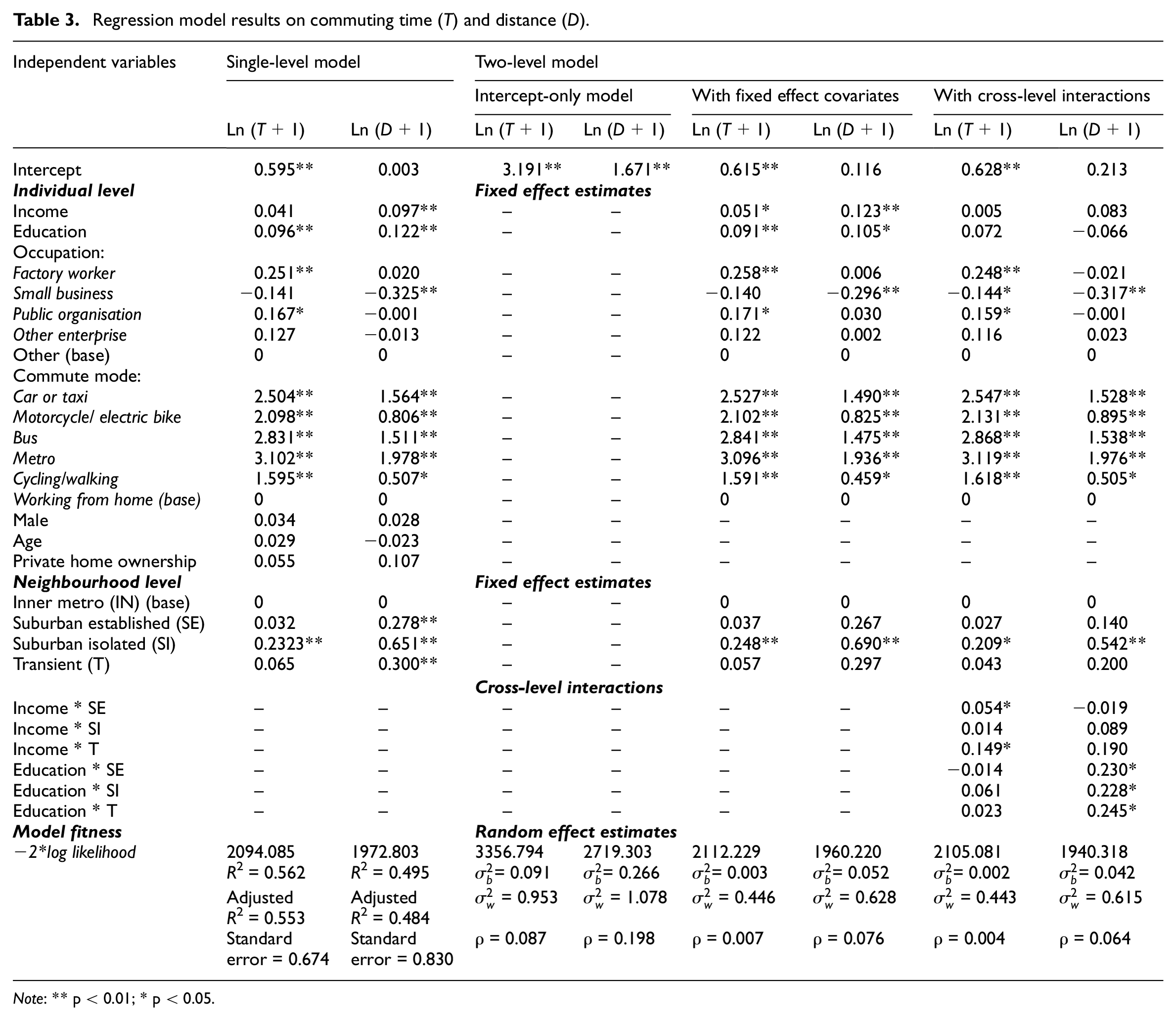
Note: ** p < 0.01; * p < 0.05.
Two-level model (a): The intercept-only model
The findings of the single-level model suggest that there may be hierarchical relationships between individual-level and neighbourhood-level data in relation to commuting time and distance. The ‘intercept-only’ model without covariates was thus performed to examine the relative importance of individual neighbourhoods in explaining variations in commuting time and distance by calculating between and within neighbourhood variances. The results in Table 3 show that the variances of commuting time and distance (ρ) are 8.7% and 19.8%, respectively, indicating a stronger influence of neighbourhood on commuting distance. The result justifies the need to examine commuting variations at the fine-grained spatial scale of neighbourhoods with a multilevel model.
Two-level model (b): With fixed effect covariates
Individual-level variables and neighbourhood types were added to the two-level models to reveal their relationships with commuting time and distance. As shown in Table 3, neighbourhood effects on commuting time and distance decrease to 0.7% and 7.6%, respectively, after introducing individual-level variables. Whilst a neighbourhood effect (mainly related to suburban isolated neighbourhood group) is strongly evident on commuting distance, the effect is negligible for commuting time (less than 1% of variance). This suggests that individual-level variables have a stronger relationship with commuting patterns, especially with commuting time. For the commuting time model, the most significant individual-level variables are commuting modes (all positively related, especially to metro, bus and car/taxi) and occupation type (factory and public organisation workers), but there is only a weak relationship with education and income levels. For the commuting distance model, commuting modes are all positively related (particularly metro, car/taxi and bus), as are income and education levels. However, as expected, commuting distance is negatively related to small business.
Two-level model (c): With cross-level interactions
In order to explore how variables at different levels influence commuting time and distance, cross-level interactions were examined in the two-level models. As shown by the fitness of model statistics in Table 3, the cross-level models perform better than the former models by having lower −2*log likelihood values. In the previous models, both income and education levels have very low coefficient values; however, in the models considering cross-level interactions, they are found to have interactive effects with neighbourhood types to provide a more nuanced explanation. For the commuting time model, individual-level variables have the strongest explanatory power – mainly by commuting modes and occupation types (positively related to factory and public organisation workers, but negatively related to small business). The neighbourhood-level variable has weaker explanatory power and is only related to the suburban isolated neighbourhood type. There is some weak interactive effect between income and all the non-inner metropolitan neighbourhood types. However, the variables influencing commuting distance are different from the commuting time model. The suburban isolated neighbourhood type has the largest coefficient in explaining commuting distance, followed by the interactive effects between education level and all the non-inner metropolitan neighbourhood types. Individual-level variables have weaker effects in this model (when compared with the commuting time model), with commuting distance negatively related to small business, but positively related to all commuting modes.
Key model findings
The findings in Table 3 confirm the advantage of adopting a two-level modelling approach to examine the key determinants of commuting distance and commuting time. The multilevel models help to disentangle the contribution of individual-level and neighbourhood-level variables, and their interactive effects on commuting patterns. While different models have different specifications, some general patterns emerge. Of the individual-level data, it is clear that commuting modes (especially metro) are strong explanatory factors and are positively related to commuting distance and time. This is then followed by occupation types, as factory workers and public-sector employees tend to have longer commuting times whereas the opposite is true for those in small businesses regarding commuting distance. It is interesting to note that both education and household income levels are weakly related to commuting patterns. At the neighbourhood level, it is clear that the suburban isolated neighbourhood group is strongly related to commuting distance and time. However, the most interesting findings are the interactive effects between all the suburban neighbourhoods and the individual variables of income and education levels. Regardless of which type of suburban neighbourhood, the higher income residents have longer commuting times; likewise, in all these suburban areas, the more educated residents have longer commuting distance.
Urban expansion, planning and spatial mismatch of home–work locations
Based on the empirical findings, this section draws out some planning implications for achieving more sustainable forms of urban development.
Spatial decentralisation and mismatch of home–work locations
The spatial concentration of employment opportunities in the urban core and the northern part of Beijing, in contrast to the spatial decentralisation of residential locations, has resulted in the lengthening of residents’ commuting distance in the outer metropolitan neighbourhoods, as witnessed in the suburban established and isolated neighbourhood groups. The commuting flow patterns highlight the spatial mismatch between residential and employment locations in the BMR. This is evident from a decrease in the self-containment level, the lengthening of commuting distance and time, and an increase in the use of private cars from the inner metropolitan neighbourhoods to the suburban areas. The inner metropolitan group and the suburban established group have similar qualification, occupational and household income profiles, though the latter has a younger age structure. The physical distance of their residence from the main employment centres means that the suburban established group has a much lower self-containment level, fewer commutes by walking or cycling, and longer commuting distance and time than the inner metropolitan group. The transient neighbourhood group (including urban villages and small property housing), with unique circumstances of informal development and collective land ownership, has the highest self-containment level as a large proportion of residents either work locally (32%) or have very short distance commutes.
The diverse and complex commuting flow patterns exhibited in Figure 1b clearly show that the Beijing government’s long-time decentralisation effort towards a polycentric structure, through successive master plans, has not been successful. The main challenge for decentralisation continues to be the creation of job opportunities in the subcentres. Nonetheless, the commuting patterns reveal that the northern districts are more spatially integrated than the southern and the eastern areas (the western districts are mountainous regions). In other words, a north–south divide exists in Beijing’s home–work relationships and this divide has been accelerated by the strategic decision to locate the Olympic zone in the already advantaged northern districts, especially Haidian and Chaoyang. The northern districts thus continue to be the centre of job opportunities and residents in the nearby suburbs have benefited from such geographical proximity. This is reflected in the shorter commuting distance of the suburban established neighbourhoods located in the north (average 9.7 km) in comparison with their counterparts in the south (12.4 km) and the suburban isolated neighbourhoods (14.6) 2 in the southern and eastern parts of the region. Even for the more self-contained transient neighbourhoods, there is a distinction between those located in the north (4.4 km) and the south/east (9.5 km).
Residential decentralisation without comprehensive planning
While there is a sharp contrast in the commuting patterns between neighbourhoods in the inner metropolitan and the outer metropolitan areas, there are also major variations between different suburban neighbourhood types. The suburban established neighbourhood group has a shorter average commuting distance but longer commuting time when compared with the suburban isolated group. This is largely due to the severity of road traffic congestion and the high metro passenger volume experienced in the peak hours around the northern areas. For example, the Beijing government in the late 1990s initiated two mega affordable housing projects in Changping to house over 60,000 people in Tiantongyuan and Huilongguan. However, as the biggest ‘sleeper’ towns in Beijing, they are notorious for suffering from severe traffic congestion and poor public service provision. This is evident in our survey, as only 11% of residents work locally in Tiantongyuan No. 1 neighbourhood (in the suburban established group), with an average commuting distance of 11.5 km and commuting time of 50 minutes. A senior planning official publicly admitted that these mega communities lacked comprehensive planning, 3 with infrastructure and public facilities being gradually added to improve their liveability.
The neighbourhood types, as basic spatial units of trip generation, can be seen as proxy measures of the development outcomes of different spatial and temporal urbanisation contexts. The characteristics of the neighbourhood types and their commuting patterns confirm that new residential development during the rapid suburbanisation process has met with insufficient and delayed infrastructure provisions. Despite the Beijing government’s investment in major public transport infrastructure, the distribution of the metro network is rather uneven, with sparse distribution and density beyond the 5th ring road and a north–south discrepancy. For long-distance commuting, the metro is a major transport mode for those living in the suburban areas to avoid traffic congestion. The capacity of public transport in the city has reached its limit, as ‘long waiting times’, ‘too crowded’ and ‘poor network coverage’ are frequently mentioned by survey participants.
Commuting patterns, commuting modes and neighbourhood factors
As shown by the regression model findings, the suburban isolated neighbourhood group is consistently found to have long commuting distances and times, which are related to its poor transport infrastructure in terms of poor metro accessibility and that nearly 45% of the workforce are factory and public-sector workers who tend to have longer commuting times. The modelling analysis also highlights that neighbourhood types only explain a small amount of commuting variations, which suggests that it is personal resources that are more related to commuting patterns.
Residents with access to more resources have more means and options to maximise their overall utility when selecting residential neighbourhoods. Personal socio-economic characteristics have an immediate impact on the choice of residential location, which is nested within a neighbourhood as the basic spatial unit of trip generation. Moreover, the interactive effects between all the suburban neighbourhoods and the individual factors of education qualification and household income clearly show that commuting patterns are rather complex: they are predominantly driven by individual attributes which also interact with the locational conditions of neighbourhoods. Hence, suburban established neighbourhoods, including former danwei housing and economical and comfortable housing, 4 tend to enjoy better infrastructure and metro provision than the more recently developed isolated and transient neighbourhoods. Without good metro access, private car/taxi and bus become important alternatives for commuters in isolated and transient neighbourhoods. A commute can thus be seen as a product of an individual’s choice and compromise, driven by a combination of socio-economic and locational factors, to maximise his/her utilities and needs.
Planning for sustainable development and urban expansion
Master planning in Beijing has played a pivotal role in the spatial sorting process so that residents with different socio-economic profiles congregate in different neighbourhood types. As our spatial cluster analysis demonstrates, urban form (e.g. access to public transport, population density), institutional factors (e.g. land right), house price and time of development all play a part in shaping neighbourhoods with different characteristics and socio-demographic structures. Planning in Beijing has been dominated by administrative interventions that aim to deliver immediate spatial outcomes, such as in situ housing for land-losing farmers and arbitrary locations for affordable housing; which tends to strengthen the spatial sorting process of winners and losers to repurpose and reconfigure different urban spaces and neighbourhoods across the city (Wong et al., 2018a). To achieve more sustainable commuting patterns and the spatial integration of the labour and housing market, planning is critical in shaping the formation and quality of neighbourhood development. Our research findings clearly show that sporadic residential development in peri-urban locations can result in unsustainable isolated neighbourhoods. More rigorous assessment of the spatial effects of continuous suburbanisation, in terms of home–work locations and the implications for different socio-economic groups, has to be adopted in urban master planning to provide adequate and quality public transport infrastructure and public services to deliver the so-called ‘new type of urbanisation’ that is human-centred and adheres to the principles of ecological civilisation. 5
With continuous urban expansion and cheaper house prices in outer metropolitan locations, there might be more residents choosing to live further away from the urban core to gain bigger living space and be closer to nature. From a sustainable development perspective, concerted efforts should be made to provide more employment opportunities in the southern and eastern outer metropolitan areas. Since the co-location thesis is not easy to deliver, especially in the short term, the alternative is to improve the distribution and density of public transport, especially the metro network, and to discourage the use of motorised transport modes.
Conclusion
This paper innovatively adopts a spatial perspective to analyse the commuting patterns of four neighbourhood types in the BMR. It contributes to existing literature by combining traditional built environment measures and variables measuring inherent neighbourhood characteristics and development time periods in the neighbourhood classification to reflect different spatial–temporal urbanisation processes. Commuting flows from different neighbourhoods and their relationship with main employment centres in the BMR were examined by GIS mapping and overlay analysis. Variations in commuting time and distance were analysed with multilevel models to establish how individual socio-economic attributes and neighbourhood factors, as well as their interactive effects, explain the varied commuting patterns. From a methodological perspective, the research takes a step further in developing more robust models by analysing variables at different levels. The cross-level interactions of variables shed new insights into our understanding of complex commuting patterns, in terms of the predominant influence of individual attributes, which also interact with locational conditions of neighbourhood with differential explanatory power.
The findings have provided a vivid understanding of the spatial relationships between home and work locations in different parts of the city-region and highlighted the fact that the lack of comprehensive and integrated urban planning has accelerated the separation of home–work locations and lengthened work journeys and commuting times in the suburban neighbourhoods located in the outer metropolitan area, particularly those in the eastern and southern parts of the BMR. The spatial outcomes and commuting dynamics in Beijing are inherent products of spatial policies and market forces in the context of rapid urbanisation and development. Multilevel analyses from a spatial planning perspective do not only inform planning for sustainable urban development in China, but also shed light on cities undergoing rapid development in the wider international development context.
As commuting patterns are dynamic and subject to the evolving urban spatial structure, it is crucial to develop a long-term, integrative spatial planning strategy. The latest 2016 Beijing Master Plan has sketched out Beijing’s polycentric spatial structure with very specific principles (Beijing Government, 2017). The delivery of this blueprint, especially with a more specific and structured system of new towns, will no doubt bear major impacts on the spatial relationships of home–work locations. This new plan also elevates Tongzhou new town as Beijing’s sole subcentre and reduces the number of satellite towns from eleven to five. Three of the new towns are indeed located in the southern area of Beijing, connecting to the newly planned Beijing New Airport and Xiong’an New District, to develop strategic regional integration with neighbouring Tianjin and Hebei. The BMR will thus continue to be a fertile ground for future research to monitor the impacts of master planning to realise the objectives of a new type of sustainable urbanisation.
Footnotes
Acknowledgements
We would like to thank Professor Shenjing He and three anonymous reviewers for their helpful comments. Our special thanks are also due to Professor Pengjun Zhao and Drs Yun Qian, Chao Ren, Lei Wang and Yinxuan Huang for their assistance and advice on the fieldwork and data analysis.
Funding
The material in this article is based on research funded by the UK Economic and Social Research Council (Grant Number ES/N010698/1) on ‘Eco-Urbanisation: promoting sustainable development in metropolitan regions of China’.