
Abstract
This article provides an account of how spatial divisions permeate imaginaries of the UK’s geography, drawing on a large qualitative data-set on the locational choices of young adults. The data we draw from are unique in their multi-sited design, which includes accounts of how young people look upon the UK’s internal geography from 17 geographic vantage points, that span the four UK nations and each region of England. Data collection involved an innovative mapping exercise capturing how their spatial imaginaries are relationally constructed, and the demarcation of spatial boundaries. Drawing parallels with research on the way divisions are constructed globally by internationally mobile students, we argue that the young adults’ spatial imaginaries were infused with intranational boundaries of uneven economic development, national identity and ethnicity. Their spatial imaginaries and the geographic divisions they embody have important implications for public policy that seeks to redress spatial inequality within nations like the UK.
Keywords
Introduction
Spatial divisions are a defining characteristic of the UK’s internal geography and have been a long-standing public policy concern. The UK has by far the greatest regional inequality of any European country as measured by GDP per inhabitant, with regions growing further apart over time. These economic divides stand alongside, and are to some extent connected to, divisions of ethnicity and nationhood, with the UK characterised by ethnic residential segregation (Harris, 2014) and the historical subjugation of Wales, Scotland and Northern Ireland (Hechter 1999). In this article, we draw on a multi-sited study of how young people across 17 different locations looked upon the UK’s internal geography, and the way in which these divisions manifest in their spatial imaginaries.
A number of studies have addressed the way places are perceived and explored how differently positioned actors are able to ‘anchor’ themselves spatially, often drawing on rich data of particular localities. In research on higher education choice, the identifications with place and meanings imbued within it have been found to be important in keeping some young people rooted (Hinton, 2011). Henderson’s (2020) study demonstrated the significance of shared and collected narratives of place, which are often inherited, and draw associations between the educational capabilities and trajectories and those in particular local areas. It shows how these are often inherited and stem from a local area’s past, in the case of Henderson’s (2020) study, the locality’s industrial past lived on in contemporary subjectivities. Along similar lines, Holdsworth (2009) has addressed the mutual exclusivity of ‘local’ and ‘student’ identities perpetuated by the lack of interaction between ‘locals’ and ‘students’ in the context of Liverpool. Our own research has considered the significance of regional consciousness in driving locational choices (Donnelly and Gamsu, 2018), as well as the relationship between the ethnic composition of a young person’s home locality and their choice of location for university (Gamsu et al., 2018).
Work on the ‘everyday mobilities’ of local students has questioned the assumed ‘immobility’ of those who stay living at home for university (‘commuter students’), exposing the emotional and relational aspects of mobility in a liminal sense (Finn, 2017; Holton and Finn, 2020). The idea of ‘mobile dwelling’ is used to illustrate how students can be physically present in university spaces, but emotionally distant – underlining the complexity of what it means to be mobile. For those living at home, Holton and Finn (2020) also discuss the significance of feelings towards spaces of memory and long-term attachment, which had been re-imagined through their new encounters within these spaces as university students.
The uniqueness of our data-set lies in its geographically multi-sited case study design, which offers an opportunity to observe how diverse spatial locations affect how groups look upon space. In adopting this design, a key contribution of our research is to shift thinking on domestic student mobilities towards debates about internal imaginaries and divisions within the context of a socio-politically and socio-economically distinct UK context. It expands on the research that has studied in-depth subjectivities within local areas, to consider how different cities, regions and nations of the UK are perceived and stand in relation to one another. In doing so, we provide an account of divisions that exist internally within the UK’s geography, as they manifest themselves through young peoples’ mental maps of the UK.
In addressing geographic divisions embedded within spatial imaginaries, we draw especially on
Our analysis also takes conceptual framings from research that has considered spatial imaginaries and divisions globally, taking the case of studies into international student mobility. Although a different geographic scale, we find some conceptual parallels here between the kind of divisions that exist globally and those that prevail internally within nation states like the UK. We begin by considering the possible applicability of this research on international student mobility.
Applying Insights from International Student Mobilities
The origins and destinations of international students are often discussed in relation to unequal power structures that exist globally, with movements from Global South to Global North countries most common, or between Global North countries themselves. These mobilities are not a ‘one off’ haphazard migratory act, but are often embedded within longer-term locational strategies and imagined future selves (Findlay et al., 2012, 2017). For example, Perkins and Neumayer (2014) have illustrated from their large-scale quantitative data that the numbers of universities featuring in international league tables makes little difference to country inflows; more important are income levels, historic ties created by colonial links, language and the presence of existing migrants.
Madge et al. (2009) lucidly argue that postcolonial discourses influence international students’ locational choices, with the lasting legacies of colonial power continuing to reproduce the idea of, for example, a ‘British education’ as superior. Notwithstanding the symbolic value of credentials, meanings are often attributed to place in other ways beyond education. Research by Collins (2014) draws on the example of Seoul as a place that is imagined as an ‘iconic centre’ by international students, holding symbolic potency and opening up connections and networks that are perceived to reap rewards in capitalist labour markets. Strikingly, Beech (2014) found internationally mobile students held nuanced perceptions on places within the UK, but also that these did not always reflect their lived reality of life in these places. For one participant in her study, the city of Nottingham did not reflect what he had imagined as life in Britain, with Chippenham cited as a place he felt was ‘truly British’. In this sense, internationally mobile university students are often choosing places as well as choosing universities.
It is clear from what we know about the international movement of students that uneven economic development and the lasting legacy of colonialism are important forms of demarcation in their global spatial imaginaries. But it has also been demonstrated that spatial imaginaries and locational choices can be further underpinned by perceptions of place that are intertwined with ethnicity and nationhood. Conceptual parallels can be drawn here with the internal geographic divisions evident within countries like the UK. While a post-colonial framing cannot readily be applied in the same way to the case of Britain’s internal geography, it is commonly acknowledged that there has been an historically uneven spatial patterning to economic development and prosperity within the UK. London and the South-East continue to be the centre of economic, political and cultural power, with peripheral areas that have faced post-industrial decline and marginalisation. An important contribution we make here is to underline the lasting legacy of uneven economic development in shaping the spatial imaginaries of young people in terms of how they relationally construct dominant (like London) and dominated places.
Perceptions of place that are intertwined with ethnicity and nationhood are also likely to be significant given the uneven spatial patterning of ethnic groups in the UK (Catney, 2018) as well as the historical marginalisation of Wales, Scotland and Northern Ireland (Hechter, 1999). The minority ‘home’ nations of Wales, Scotland and Northern Ireland have distinctive national identities, maintaining their own languages and cultures, and having a history of being unequally positioned in relation to England in the context of the UK’s spatially uneven national development (Hechter, 1999). A second important contribution of our analysis is to show how race and ethnicity also permeate spatial imaginaries that shape identifications with place.
Methods and Data
The data we draw on here were collected as part of a three-year study addressing the question of how the internal geography of the UK is imagined by young people (aged 17/18) located in different spatial vantage points. To see how these distinct vantage points shaped how they looked upon the UK, we adopted a multi-sited design, involving qualitative interviews with over 200 young people across 17 different geographic localities. This afforded an understanding of how geographic and social origins shape the way perceptions of place are constructed (e.g. perceptions of London from the vantage points of Liverpool, Bristol and Newcastle). All four nations of the UK (England, Scotland, Wales and Northern Ireland) were included as well as each region of England (North-West, North-East, Yorkshire/Humberside, East/West Midlands, South-East, South-West and London). The 17 localities encompass Tyneside, Greater Manchester, the cities of Liverpool, Birmingham and two parts of Glasgow, two further northern towns, three different parts of London, a town in the South-West of England, an East Anglian coastal town, two coastal towns in South Wales and West Wales, a North Wales town and a city in Northern Ireland.
An initial questionnaire facilitated the selection of this diverse sample, and a ‘mapping exercise’ also allowed the selection of participants who appeared to vary in their perceptions of place. The ‘mapping exercise’ involved participants being presented with a blank map of the UK and were asked to colour it according to their spatial preferences: green, ‘places where you would prefer to live for university’; red, ‘places where you definitely do not see yourself living for university’; orange, ‘places where you would not mind or are indifferent about living for university’; and blue, ‘places you do not know or haven’t really thought about’. A map created by one of our participants, Murali, whom we discuss later, is provided here as an example to illustrate (see Figure 1). The map was left blank without place names, borders or boundaries with the deliberate intention to ensure their spatial imaginaries were not being framed for them as far as possible. In this way, there was an attempt to allow participants to show us their spatial imaginaries and the kinds of divisions these embody. We have discussed the ‘mapping exercise’ in greater depth elsewhere, including its key affordances for capturing spatial imaginaries (Donnelly et al., 2020).
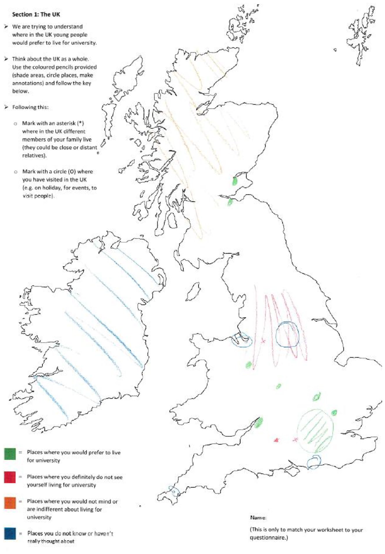
Exemplar of mapping exercise – Murali’s map.
The maps were not only used as a means of selecting participants with varied spatial preferences, but were also used as a guide within interviews to elicit how young people perceived geographic space. Interviews (which lasted around 40 minutes to one hour) were loosely structured, took place within the school context and always began with the question ‘tell me about your map’. This was an intentionally open-ended question to allow participants to narrate in their own terms how they imagine the UK’s internal geography. Follow-up questions homed in on where they took the discussion, often focused on spatial areas they had marked out as distinct, but also probing them about places they had not mentioned or coloured at all – places that were seemingly off their map. The data were thematically analysed with an initial broad thematic coding that identified themes that were later refined, with more focused coding on key themes that emerged.
It must be noted that the two interviewers carrying out the research are male and from northern England, which, if discernible to participants, could have potentially impacted on how some talked about differences between places. The fact that the interviews took place within their school context could conceivably have also impacted on the kinds of things participants felt able to discuss. Data were collected in line with British Educational Research Association (BERA) guidelines for ethical research, with voluntary informed consent maintained (no incentive was offered), and data thoroughly anonymised (pseudonyms are used for all participants, as well as locality and school names).
Imaginaries of Geographic Division within the UK
As discussed above, we draw on conceptual framings from the study of international student mobility to understand the spatial imaginaries of young people in the UK. In what follows, we first discuss the significance of uneven economic development, before moving on to consider perceptions of place that are intertwined with ethnicity and nationhood.
Uneven Economic Development
Like the internationally mobile students, uneven economic development was significant in shaping the way in which value was ascribed to different places within the UK. On a conceptual level, the kind of economic divisions evident internationally between countries could also be seen intranationally within the UK, and we discuss this here in terms of dominant and peripheral places.
Iconic Centres
The iconic city of Seoul weighed heavy in the minds of the internationally mobile students in Collins’ (2014) research. The imaginary of ‘iconic centres’ was also important in how some domestically mobile British young people framed and understood places within the UK. Conceptually speaking, the same social mechanisms are apparent here in imagining where are the ‘centres’ of economic, symbolic and cultural power (although the scale of actual differences are clearly different). In the same way as Seoul was imagined as a place where exposure to facets of modernity, including desired social networks, multinational companies that dominate economic activity and technological advancements, privileged young people in the UK depicted the city of London along similar lines. Economic centres like London were often characterised as ‘hubs’ where valuable networks and resources can be realised and ‘cashed in’. Camilla, who came from a relatively privileged family background (NS-SEC group 2)
1
and attended a private school, demonstrated this kind of imaginary in describing London:
Right, what do you mean, vibrant? You want to be somewhere more vibrant, what does vibrant mean to you? What’s-
Like, London is vibrant, there’s loads going on there are loads of people around you. There’s lots more career opportunities in vibrant areas I think, like LSE [London School of Economics and Political Science] is right next to like the City of London, it’s right next to all the big law firms, which is what I’m interested in doing. Whereas Oxford, you’ve got a couple but there aren’t that many, and there are lots of good students competing to get work experience and stuff there. But yeah, vibrant would be lots of stuff going on, lots of people around, stuff to do, yeah. (Camilla, white, NS-SEC 2, parents Higher Education (HE) educated, Barnmouth College, Barnmouth – town in South-West)
Unpicking what ‘vibrant’ means to Camilla, it is likely this is interpreted in terms of London’s connectedness to high-status symbolic, cultural and economic power. On the career section of the Law department at LSE, they promise students: ‘Employer and alumni insights including presentations and coffee mornings.’ While all universities are now a hive of careers-related activities of this nature, Camilla is cognisant of the kind of connections to law firms head-quartered in London that are high-status in the field of law. But it is not just the firms themselves, it is the social connections and networks embedded within London, of which LSE is an integral part, that act as important conduits. These early thoughts are indicative of a disposition and orientation focused on positioning oneself next to the dominant institutions in the field of law:
Well, what do you mean big law firms?
Well, I want to be a lawyer and so, some of the really big law firms like Freshfields and Bondickers- and stuff like that
What did you say? Bon-dickinson?
Right. They’re- there’s one in Barnmouth and they’re kind of all the way across the South-West. They’ve got really good offices and if I were in a university nearby, a lot of the universities I’ve been to have said that they get these lawyers to come in and speak to us
Oh do they?
And we get like, career work experience, what have you, kind of with them, so I think that would be really beneficial. (Camilla, white, NS-SEC 2, parents Higher Education educated, Barnmouth College, Barnmouth – town in South – West)
Camilla’s spatial imaginary corresponds to this unequal spatial division of labour (Massey, 1994), with her positioning of London as the centre (where the companies that dominate the field of law are located) as opposed to provincial towns and cities outside of the capital. In the spatial organisation to relations of production, London might be considered a ‘centre’ because it is likely where the high-status roles and functions take place, while large firms might distribute the ‘back office’ functions to its offices in peripheral towns and cities outside of London. This is highly likely to be the case in sectors like Finance, Consulting and Accountancy, as our previous research on elite firms in these sectors demonstrates (Donnelly and Gamsu, 2019). Following Massey (1994), the ‘centre’ in this sense is the controller of capital and labour that is carried out by dominated places and locales on the periphery. In the same way that Seoul was perceived as an urban locale that afforded access to prestigious Korean companies, in the mind of Camilla, the companies that occupied dominant positions within the field of Law (following Bourdieu, 2013) were all located in London. London was where people could develop the kinds of social connections, or social capital, that would allow access to these dominant firms and positions.
This does not likely represent a ‘one-off’, haphazard event for Camilla; it is embedded within a longer-term social class trajectory stemming from childhood and early socialisation at home and school. The value attached to high-status positions, of whatever field Camilla happens to situate herself within (in this case, Law, which is a dominant occupational field in itself) would have likely come from expectations instilled at home and the elite school she attended. It is entirely natural for Camilla to think about London (not a provincial town or city) because it is the place where she needs to be to secure the kind of classed future she imagines.
These spatial distinctions were evident for other young people within the sample who occupied the most privileged social positions (especially those privately educated and in NS-SEC group 1). For example, in describing his map (see exemplar map, Figure 1), Murali, makes similar distinctions: I would like to be more [inaudible] based, like I was saying about based in- or at least around London or in the South. Umm.
And that is because of the city?
Yeah, the city connection and all that kind of thing, umm, and I haven’t really given much consideration to the South, South-West
Yeah, what do you imagine Wales and the South-West is like in comparison to-
Umm there is a lot of sheep there, is that right? [Laughs]
[Laughs]
Umm, I don’t know, the South-West would be nice because if it is near the beach that would be nice, umm . . . but Wales doesn’t really interest me to be honest. Wales, it seems like a bit of a gloomy sort of place I am definitely not interested in Wales or Northern Ireland for example. (Murali, Asian, NS-SEC 1, Brasenose School, Manchester)
Looking at Murali’s map, the geographic areas of Wales, the South-West of England and the North-East are left completely blank – and conspicuous by their very absence. It might be indicative of him simply not knowing these areas (which could be telling in itself, in terms of the places worth knowing). But at the same time, there are other places (notably the South-East and London) that are clearly visible and valuable to him. Wales is considered by Murali as a place of leisure, a place close to the beach, not the kind of ‘iconic centre’ where he needs to be. Like Camilla, the symbolic potency of London comes out strongly in Murali’s narrative; the ‘connections’ that Murali speaks of in London are likely to be along the same lines – connected up to dominant economic, cultural and political structures of power.
Marginalised and ‘Off the Map’ Places
Madge et al. (2009) used the idea of ‘colonial imaginaries’ to describe the lasting legacies of colonial power in the dominance of western degree credentials. While not directly comparable, the broader conceptual point about historically uneven economic development, and the subsequent way in which value is afforded to different localities, can help to interpret how young people attribute value to places more generally within spatially divided countries like the UK. The differential value ascribed to places are all bound up in the historically uneven economic development of Britain (Hechter, 1999), including regions within nation states, especially industrial regions in the North and Midlands of England.
The differential value ascribed to places by our domestically mobile participants was evident from how the most privileged participants talked about economically dominated places like Wales and the North of England – places that were not always even recognised or given any consideration at all – they were a notable absence in the spatial imaginaries of our most privileged participants. There are conceptual parallels here to how internationally mobile students privilege the Global North in their choices (Madge et al., 2009), and to how parents regarded studying in Global South countries as a ‘backward step’ in research by Findlay et al. (2012). At St Alexander’s School, the elite private school in London, a teacher was surprised that, for students choosing subjects like engineering, institutions highly ranked for engineering, are often not considered at all – citing the example of Sheffield in this case. There is no question that students from this school will always be channelled into elite institutions. However, this does raise the question of whether choices are to some extent spatially contingent, and whether cities like Sheffield (a post-industrial northern English city) have the same kind of value and symbolic potency as other places with highly ranked engineering courses.
Places like Sheffield and Wales might be ‘off the map’ for some elite groups because they are historically places of labour that realised economic value for controllers of capital in places like London (Massey, 1994). This spatial imaginary was very much evident in the minds of young people today in how they framed and understood places: again up here it’s more labour more like, let’s get our hands dirty, mechanical type of stuff whereas the city is more business.
The city as in?
As in London is more business type of thing, business people, rather than maintenance.
Do you think that thing about up here being more labour are you talking about . . .?
As in a lot of people from Liverpool do a lot more labouring stuff so you’ve got your mechanics, your plumbers all that type of stuff. And I don’t know whether that’s because the pay is good or it’s just a labour thing as in the families do it and it’s sort of like carry on with that type of thing. (Daniel, white, NS-SEC 1, parents not HE educated, Bootlesfield School, Liverpool locality)
London is described here as holding a kind of symbolic potency and power over Liverpool, which is subjugated as a ‘place of labour’, reflective of a broader spatially uneven division of labour (Massey, 1994). The domination of places was exposed in more visceral ways by other participants, drawing on the materiality and perceived ‘ugliness’ of some places, especially in regions like the North of England:
Yeah, and you said you’ve got family in Manchester, Liverpool?
Yeah?
What’s it like down there what, when you go and visit them and-
Just quiet really. Um, the city, I just don’t really like the city, I just find it a bit dirty. (Isabella, white, NS-SEC 2, parents not HE educated, Kings’ Hill School, Langate Hill – northern university town)
There is not the same kind of imagined ‘vibrancy’ of London talked about by other participants from similar class backgrounds as Isabella. What it means to be either a ‘dirty’ or ‘vibrant’ city is as much to do with the historically uneven development of places and the kinds of cultural and economic capitals embedded within them in how they are imagined in the present day. Leo, also from a high social background, but attending an elite private school in London, constructed a similar narrative when talking about the ‘atmosphere’ of Leeds (a post-industrial city in the North of England):
What do you mean the atmosphere, you mean-
. . . as in, when I visited it [Leeds] did seem quite kind of, as if they were constantly living in a Sunday afternoon where it was very kind of slow pace and [sighs] it just seemed quite miserable if I’m being honest . . . it just, everything seemed really grey and even in the busiest part of the shopping centre everyone was just looking really glum um and you know, it, it just, there just seemed no vibrance to it to be honest. I think, it really did play a large factor just the actual kind of character of the area
What do you mean, glum? The people?
Well yeah as in, even they didn’t look like they were enjoying themselves you know, and they lived there so, you know it just, I just, the people I think do play quite a significant role in my decision to, on where I want to live and if they’re really not enjoying it then I don’t think you know, I would-
Mm
I think it just, it just adds to this um this kind of reputation and
Mm
atmosphere that you’re in. Yeah. Um, but yeah I think I spoke to my, my dad and my brother about Exeter before and I mean, they both said they’re loving it or loved it um and, you know so that, that played a large um factor for me because um, I mean my brother who is studying geography if he’s saying he likes it you know it’s got to have some merit to it
Mm
and having visited it, it just, it kind of consolidated that. Um, so although for example speaking to relatives did influence me, I think there was a be all and end all. (Leo, white, NS-SEC 1, parents attended university, St Alexander’s School, London)
His depiction of Leeds as ‘glum’ and seemingly boring with ‘miserable’ people is all the more striking because he goes on to say Exeter is somewhere he would feel more comfortable – despite Exeter being a smaller city in a largely rural part of South-West England, with comparably less diversity in cultural, economic and social activity. It might be that Leo’s description here is as much about spatially uneven economic power structures, manifest through the higher rates of poverty and unemployment in northern towns and cities. What is meant by ‘glum’ in this sense is more about not having the same economic, cultural and social conditions as dominant groups. Exeter itself is an affluent city with the university attracting a higher proportion of privately educated students than Leeds. The assurance Leo gained from his family members was perhaps grounded in the fact that ‘people like him’, in terms of their classed preferences and dispositions, felt able to ‘anchor’ themselves in Exeter. In this sense, Leo was perhaps confident that he too would be able to exercise his class subjectivity in a place like Exeter. This comparison of Exeter and Leeds underlines the significance of economic geographic divisions in the spatial imaginaries of young people.
Internal Boundaries of Ethnicity and Nationhood
The previous section described how young people circumscribed places of belonging based on affinities with their class background, and this next section moves on to consider attachments to place based on affinities with race, ethnicity and nationhood. Ethnicity, race and nationhood were often infused and intertwined in the way young people imagined the UK’s internal geography, with parallels to be drawn here on the locational choices of internationally mobile students (Beech, 2014; Perkins and Neumayer, 2014).
Nationhood as a Source of Both Solidarity and Disaffection
Research on international student mobility by Perkins and Neumayer (2014) has illustrated the importance of language and the presence of existing migrants as important factors driving overseas locational choices. These cultural identifications also manifest themselves as important in the spatial imaginaries of the young adults in our research. We draw on the examples of Northern Ireland and Wales here to provide an account of how boundaries of nationhood are embedded within spatial imaginaries, underlining the importance of cultural identifications as a demarcatory force. It is especially relevant in the context of the UK’s historical development and the subjugation of Wales, Northern Ireland and Scotland, what Hechter (1999) refers to as ‘the Celtic fringe’ with these peripheral nations dominated by England. Hechter (1999) claims that over time the ethnic and cultural solidarities of subjugated nations will likely strengthen in response to power imbalances, disenfranchising of national identities, and exploitation by the dominant core. We certainly see evidence of national identity as an important demarcatory force in spatial imaginaries, with solidarities to nationhood producing distinctive identifications to places. Many of the Northern Irish young people had strong cultural and social identifications with the city of Liverpool, expressed through long-standing networks of connections and identifications:
And you said you’d always thought of going to Liverpool, what’s made you think of that?
I’ve always been a Liverpool fan, so I go over like three or four times a year anyway, and I’ve always kind of fallen in love with the city basically. So, I’ve always thought if I was to leave home, because it’s basically a home from home for me. I’ve got quite a few, like, close family friends over there, um, and obviously there’s a few of my friends who went last year who are over there now, like even I think I’ve been over seven times this year alone, just visiting people and watching football and stuff like that. So, I’ve always thought if I was to go away for three years, why not do it there?
And what started you off being a Liverpool fan?
I don’t know, just, my dad was a fan, my mum was, my grandad was, and it’s always just kind of, it went the whole way down. (Michael, white, NS-SEC 2, Carrickwalter Academy School) loads of people from Derry go over there so it would be good, like it’s a good environment to go one day. It’s, because it’s like a different country but it’s all within a community that you would be used to. (Grainne, white, NS-SEC 1, parents HE educated, Ballygelvin RC Grammar School)
In their different ways, Michael (who eventually went on to attend a university in Liverpool) and Grainne both identify Liverpool as a ‘home from home’ owing to their sense of identification with the city often through networks of family, friends and peer group, which in Michael’s case reflects a long-standing intergenerational familial linkage. In this sense, their imaginaries of nationhood extended out beyond Northern Ireland across the Irish sea to the fringes of northern England. Liverpool was imagined as a place they could ‘anchor’ themselves through maintaining ethnic solidarities with Northern Irish culture and identity that are manifest materially and socially within the city. These affinities with place mirror how young people circumscribed places of belonging based on affinities with their class background, as discussed in the previous section. However, while this had the effect of anchoring some young people, it was also apparent that for others, boundaries of nationhood could have the opposite effect: Then there’s [pause] Liverpool, I wouldn’t really wanna go to because, like my brother goes to Liverpool and he loves it, but he [pause] has always been like, a Derry boy kind of thing . . . so many of his friends that are over there now. So he’s now like going into a house with all Derry ones. So, but I just wouldn’t – that wouldn’t be for me really.
What’s a Derry boy? How would you describe a Derry boy?
I don’t know [both laugh]. I don’t know he’s just very [pause] he’s just, I don’t know he loves like, the atmosphere of Derry and like I love it too but it’s just not what I, I don’t want to be like that for another like, four years or so.
How would you describe like, the atmosphere of Derry, would you say?
Um [pause] I’m not sure, like it’s a really really friendly city. But I just, like there’s a certain kind of [pause] feeling about it that I kinda wanna, I think it’s just ’cause I kinda wanna like, get away and experience a new culture. And I don’t think Liverpool would really do that, because so, like, so maybe people from Derry go there. (Maire, white, NS-SEC 1, parents HE educated, Ballygelvin RC Grammar School)
For Maire, cultural identifications with Liverpool and the ethnic solidarities they produced acted as a source of disaffection with the city, expressed in her desire to experience ‘a new culture’ – the affinities with Northern Irish identity found in Liverpool ruled out the city for Maire. Parallels can be drawn here with research on international student mobilities, with overseas study rationalised as a chance to experience new cultures and a sense of adventure experiencing the ‘unknown’ (Brooks and Waters, 2016). What is striking from Maire’s account is the fact that Liverpool is outside of Northern Ireland geographically, but in terms of her spatial imaginary, it is very much within the bounds of Northern Irish culture and identity. This underlines the significance of imagined social and cultural boundaries embedded within spatial imaginaries.
Boundaries of nationhood can also manifest themselves internally within nations themselves, as can be seen from the case of Wales. Our data show that Welsh identity is an example of where ethnic solidarities created some degree of internal conflict – on the one hand, imaginaries of ‘Welshness’ were important for ‘anchoring’ some Welsh young people in Wales, while on the other hand, it was a source of internal exclusion. There is a distinctive geography to Welsh identity that is helpful to draw on here. Based on language and self-identification, Balsom (1985) suggested a ‘three Wales’ model of Welsh identity: (1) a Welsh identifying group stretching across the North and West of Wales (‘y Fro Gymraeg’, which roughly translates to ‘the Welsh language area’); (2) a Welsh identifying, non-Welsh-speaking group in the valleys and major cities of the South (‘Welsh Wales’); and (3) a British identifying non-Welsh-speaking group in the East and the county of Pembrokeshire (‘British Wales’). Abereynon was our locality which Balsom (1985) describes as the ‘Welsh-speaking and Welsh identifying region’ of Wales. For many of the participants in this locality, choosing the ‘right’ place was interwoven with their desire to speak in their mother-tongue language of Welsh, as well as a place that invoked their attachment to a sense of Welsh nationhood.
But these ethnic solidarities were not shared by those we spoke to in the Pembrokeshire locality – where Balsom (1985) describes as ‘British Wales’. Those in our Pembrokeshire locality did not have the same sense of attachment and belonging to a Welsh identity. Indeed, for some, ‘Welshness’ was an exclusionary identity, as evident here for Evan when talking about the northern parts of Wales: I feel like if I went there (North Wales) and spoke to people who, like, have been speaking Welsh their whole life, it would be even more . . . It would make me seem like I’m definitely on the outside because I haven’t got this language.
Right.
And it’d be, like, harder to, sort of, to mix with people.
So, you’d feel quite different?
Yeah. It’s that sort of feeling of not being just, like, the same as everyone else, being from a different part of Wales. And they’ll be like ‘Oh, you’re from Wales. You must speak Welsh’ and you’re like ‘Mm, no.’ (Chuckles) Not really. It’s, sort of, to do with that I think.
What, so, because you’re from Wales they might think you speak Welsh?
Like . . . because you’re from Wales you, sort of, have, like, a right to spea- ’Cos you know the Welsh are, like, probably the proudest nation on the planet. They’ll be like ‘How can you be from Wales and know, like, barely any Welsh?’ Like . . . (Evan, white, NS-SEC 6, parents HE educated, Ludton Haven School, Wales)
The (dis)connections to ethnic identities of places across the UK were at the forefront of Evan’s mind here; he saw localities of North Wales as strongly connected to ethnic solidarities of ‘Welshness’, that he felt would be an exclusionary force for him. This underlines the point about how people circumscribe places of belonging based on affinities with their own background. We saw this earlier in relation to how young people discussed place based on affinities with class, and we see here the same kind of boundaries being drawn in relation to nationhood.
Ethnic Diversity of Place
It was clear from Beech’s (2014) research on the internationally mobile that perceptions were often held about places along the lines of ethnicity; for example, living in the city of Nottingham was in reality not what the overseas student imagined to be as ‘British’, but the market town Chippenham did fit their imaginary of ‘Britishness’. It is not unreasonable to assume that these perceptions are likely fostered by racialised and classed images of ‘Britishness’ as well as the patterning of ethnic groups across the UK, and the way this shapes the materiality of places like Nottingham and Chippenham. Chippenham is white dominated, while Nottingham has a higher proportion of minority ethnic groups, reflective of the kinds of cultures and identities present materially in terms of shops/food, faith groups, events and activities. The circumscribing of places in terms of their ethnic composition was also apparent in our data. In the same way as Evan perceived the internal borders within Wales, young people of colour were especially likely to narrate places in terms of their ethnic composition:
And can you say a bit more about, urm, when you said majority white places, umm . . .
’Cus it’s, cities around Birmingham are . . . Are mixed so you’ve got a bit of everything. So you’ve got Blacks, Asians, what not and then whites, what not, Irish. People from Europe come to Birmingham Unis, University of Birmingham, Aston’s quite famous. So I think, you know, it’ll be a bit different. . . . I went to Cardiff actually. I did a delivery once at the university. Was so nice, it was so big!
Mmm. Mmm.
And it was mixed as well, mixed people and I was thinking, ‘You know what, I might come here’ that’s how nice it was. Nice place is Cardiff. (Zakir, British-Asian Bangladeshi, missing NS-SEC information, parents not HE educated, Birmingham locality)
Following Massey (1994), the cities of Birmingham and Cardiff are talked about here in terms of their connectedness to different ethnic and racial identities, which other places described by Zakir as white dominated are perceived as disconnected from. There are likely a range of factors at play here in shaping Zakir’s perception of these places. Other participants reflected on the people and groups they observed as well as their more material manifestation, through the kinds of shops, food and cultural activities present. The ‘right’ place for Zakir means a locality where Zakir feels there is a heterogenous set of connections to multiple ethnic identities. This corresponds with what we saw earlier in terms of how young people delineated places of belonging based on affinities with their class background.
Other young people of colour confided that this circumscribing of place based on ethnicity was partly a protective strategy for fear of being ‘othered’ within a locality that is largely white or facing acts of racism or islamophobia (as raised by another young person in the Birmingham locality). There were far fewer cases of white young people differentiating between places according to their ethnic composition. The occasions when white young people framed their spatial imaginaries around ethnicity, it was not based on fear of being ‘othered’ or facing racism, but rather out of a desire to broaden the ethnic diversity of their social network:
You’ve put down like um [pause] universities like Edinburgh and
Yeah
Bristol, London
Manchester
How do you think they would be different to like Great Mundesfoot?
Um, more diverse, like people as well, I’m gonna be able to meet lots of different people from all walks of life but when you’re in East Anglia it’s a lot more like, you know, you get like the certain kind of people, but if you go to big cities you can meet all sorts of people.
Yeah, certain kind of people like what kind of thing?
Oh I mean like, well like, I wouldn’t wanna like, hate on where I’m from or anything, but I just don’t like the mindset of like, um quite a lot of people in, mainly it’s just ’cause I’m so used to here or whatever but they have quite a closed, well the people that I socialise with are really close minded to be fair.
What is it about their mindset then?
Racist . . . and I can’t deal with mindset of sort of, it’s kind of like backwards, it’s not like . . . (Ethan, white, NS-SEC 3, parents not HE educated, Great Mundesfoot – coastal town, East Anglia)
The East Anglian town where Ethan lives is constructed here as connected to an exclusive whiteness and seemingly disconnected to other forms of ethnic and racial identities, which appears an important driver as to why Ethan is opting for larger cities. This is reminiscent of the kind of ‘cosmopolitanism’ associated with middle-class identity and personhood (Maxwell and Yemini, 2019). It underlines the point that spatial imaginaries of ethnicity are likely to be a crucial element in the way all ethnic groups (unconsciously and consciously) discern between places.
Concluding Remarks
Drawing parallels with research on international student mobilities, our analyses point to the significance of the way geographic divisions permeate spatial imaginaries internally within the UK. There are imagined geographic divisions (socially, economically and in terms of ethnic/national identity) between places internally within the UK, and conceptual parallels can be drawn here to the kinds of ‘social distances’ travelled by internationally mobile students. For example, while migration from the city of Beijing to the city of London represents a significant geographic distance, these cities might have a degree of congruence and ‘closeness’ socially, economically and symbolically in terms of their connectedness to global capitalism, and the facets of modernity and character Sennett (2007) appropriates to the ‘new economy’.
But it is also clear that not all social groups will equally privilege these imaginaries, and this particular imaginary of London was valorised by higher social class groups who ascribed value to these identities. This underlines the way social class is intimately bound up within conceptualisations of place; using the same qualitative data-set drawn on here, we have carried out a detailed analysis of ‘accent’ style as a manifestation of spatialised class structure (Donnelly et al., 2022). Similarly, we can see the way these imaginaries privilege different ethnic groups. The cities of Cardiff and Birmingham were perceived by one of our participants as ‘close’ in terms of being connected to a broader range of ethnic identities. It is not inconceivable that other places are likely perceived as relatively disconnected to diverse ethnic groups, and perhaps more strongly connected to whiteness (Garner, 2007). The connectedness to ‘whiteness’ is likely to be manifest in not only the people but the materiality of places, in terms of forms of consumption, cultural activities/events, faith groups, which is likely to privilege white groups. This article has largely focused on social class, ethnicity and nationhood, but we recognise that there may well be other groups, such as older adults and those with disabilities, who differ in how they stand in relation to these spatial imaginaries.
Spatial imaginaries, such as those gathered here, are an important evidence base to understand how social actors relationally construct places, the meanings ascribed to them and how they may unequally privilege different groups. The geographic divisions narrated by our participants have important implications for public policy that seeks to redress spatial inequality, of which there is a long history in the UK. Many of the public policy interventions have been economically focussed, such as the Regional Development Agencies, which were established across all regions of England to promote regeneration, business efficiency and competitiveness, employment, and skills. Most recently in England, the Conservative-led government has made ‘levelling up’ a key priority, which again appears to be an economic agenda focused on infrastructure and business. But normative forms of economic development of this kind are unlikely to fundamentally change the unequal power relations that underlie how geographic divisions are imagined across space. Indeed, the imaginary of northern cities like Leeds as ‘glum’ may well be quite separate from the economic development of Leeds itself. It also does little to change the geographic divisions around ethnicity and nationhood, which require more fundamental policy interventions.
It is also clear that there is a history of social and political divisions within the UK that have only increased in light of events such as the referendum on leaving the European Union and fall-out from the COVID-19 pandemic. These divisions are especially marked in terms of the minority nations but also within nations themselves, especially a growing North–South divide within England. Our data underline the significance of these regional divides that were ingrained in the minds of our participants even at the outset of their adult lives – suggesting their early experiences were influential in shaping them. It illustrates how any public policy intervention needs to account for the deep-seated nature of these divides, which are the product of early socialisation and likely stem from a dominant southern English core that has historically marginalised other regions of England and nations of the UK.
Footnotes
Acknowledgements
Special thanks go to the young people who generously gave up their time to take part in the research. With thanks also to those who have contributed to the programme of research throughout, especially Hugh Lauder, Ceri Brown and Arif Naveed. The thoughtful and engaging comments from two anonymous reviewers are also greatly appreciated and acknowledged here.
Funding
The authors disclosed receipt of the following financial support for the research, authorship and/or publication of this article: this research was funded by the Economic and Social Research Council (grant no. ES/N002121/1).