
Abstract
On March 10, 2016, the National Aeronautics and Space Administration (NASA) announced that it had selected 2 proposals for its Earth Venture Instrument program, which supports highly focused science investigations that complement NASA’s larger missions. The National Research Council recommended in 2007 that NASA undertake these types of projects regularly. One such investigation, the Multi-Angle Imager for Aerosols (MAIA), is designed to study the adverse health effects of respirable particulate matter (airborne particles with an aerodynamic diameter ≤10 μm, or PM10) and various components of fine particulate matter (airborne particles with an aerodynamic diameter ≤2.5 μm, or PM2.5). The budget for the MAIA investigation (cost capped at $97 million in fiscal year 2018 dollars) supports the delivery and operation of the satellite instrument and its associated retrieval algorithms and ground data-processing software, as well as aerosol and epidemiologic research by the science team. The instrument launch date depends on which satellite platform NASA chooses to host the instrument, and it is scheduled for the early 2020s.
Evidence linking disease risks and premature death with exposure to particulate matter is convincing. 1 These adverse health outcomes can be observed at relatively low levels, as measured in urban areas in the United States and Canada. 2 Worldwide, the World Health Organization estimated that in 2012, 3.7 million deaths were attributable to ambient particulate matter, about 88% of which occurs in low- and middle-income countries. 3 This finding further highlights that particulate matter air pollution constitutes the world’s largest environmental health risk.
Historically, population exposure to particulate matter has been estimated with measurements made by expensive in situ monitoring stations. However, such monitoring networks are sparse or nonexistent in many parts of the world where particulate matter concentrations are the highest. Even in the United States, the approximately 1200 stations operated by the US Environmental Protection Agency (EPA) are located in only 30% of approximately 3100 counties. Uncertainties in estimates of particulate matter exposure tend to bias the health risks toward the null hypothesis, resulting in an underestimation of public health risks. Rural and suburban populations are often excluded because of a lack of estimates on exposure.
Since the launch of NASA’s Terra satellite in late 1999, satellite-retrieved aerosol optical depth (a measure of particle light extinction in the atmosphere) has emerged as a promising solution for providing worldwide estimates of PM2.5 exposure. 4 During the past decade, various satellite-based methods have been developed to estimate ground-level PM2.5 levels to effectively augment ground-based monitoring and help fill pervasive gaps in data that impede efforts to study air pollution and protect public health. 5,6
What is missing from this intriguing picture of satellite-powered studies on the health effect of particulate matter worldwide is information on particle composition. Particulate matter includes many components that may vary in their toxicity and in the degree to which they contribute to adverse health effects. One review noted that “one of the biggest gaps in our knowledge relates to what specific air pollutants, combination of pollutants, sources of pollutants, and characteristics of pollutants are most responsible for the observed health effects.” 1 Differential toxicity can have important implications for the establishment of ambient air quality standards and for more targeted pollution control strategies. Focusing regulations on the most toxic particulate matter components could protect public health at a lower total cost. So far, only a fraction of EPA’s ground stations measure PM2.5 composition, usually on a 1-in-6-days schedule. For the rest of the world, such information is even more limited. Current satellite sensors also fall short of providing sufficient information to discriminate PM2.5 and PM10 and to accurately infer the compositional properties of PM2.5.
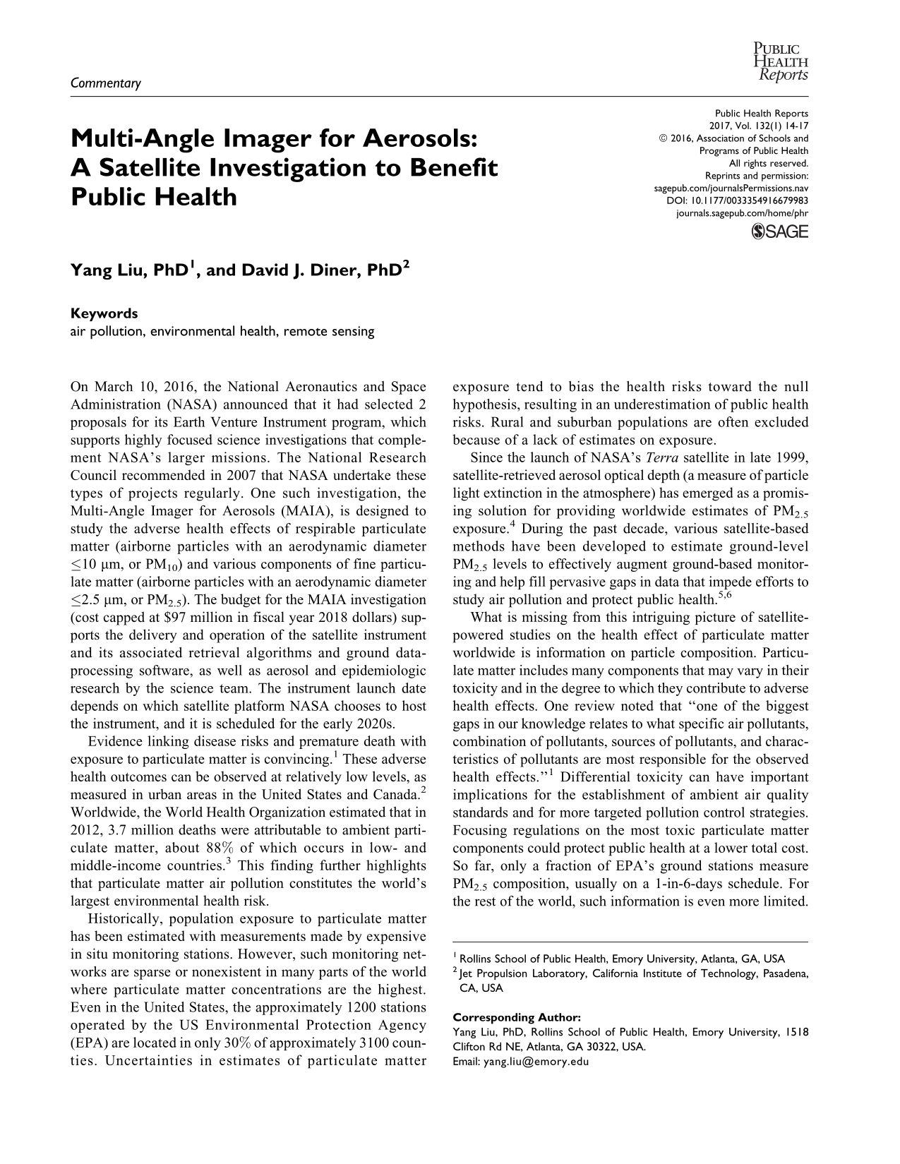
Here enters MAIA. The investigation’s primary objective is to determine the relative toxicity of various particulate matter components and to assess the effects of particle size and composition on adverse birth outcomes, cardiovascular and respiratory disease, and premature death. MAIA’s unique instrument design and innovative data processing software will generate comprehensive information on particle size distribution, shape, and light-scattering and absorption properties at 1-km spatial resolution for a set of globally distributed target areas. Sensitivity to particle size and composition is achieved by acquiring images of scattered sunlight in the ultraviolet, visible, near-infrared, and shortwave-infrared regions of the electromagnetic spectrum; by observing at multiple viewing angles; and by determining the degree to which the scattered light is polarized. 7 –10 MAIA’s novelty is to include all of these capabilities at moderately high spatial resolution. The MAIA cameras will be mounted on a 2-axis gimbal that provides multiple-angle views along the direction of flight and access to targets of interest that are not directly underneath the satellite flight track (Figure 1). Atmospheric chemistry models and spatial statistical models will be integrated with the instrument data to create a state-of-the-art algorithm to translate satellite observations into ground-level concentrations of total PM10, total PM2.5, and PM2.5 components, including sulfate, nitrate, organic carbon, black carbon, and dust.
The National Aeronautics and Space Administration’s Multi-Angle Imager for Aerosols data acquisition strategy. The instrument’s along-track gimbal enables acquisition of multiple-angle imagery of selected target areas, while the cross-track gimbal allows the targets to be observed with higher revisit frequency than would otherwise be possible.
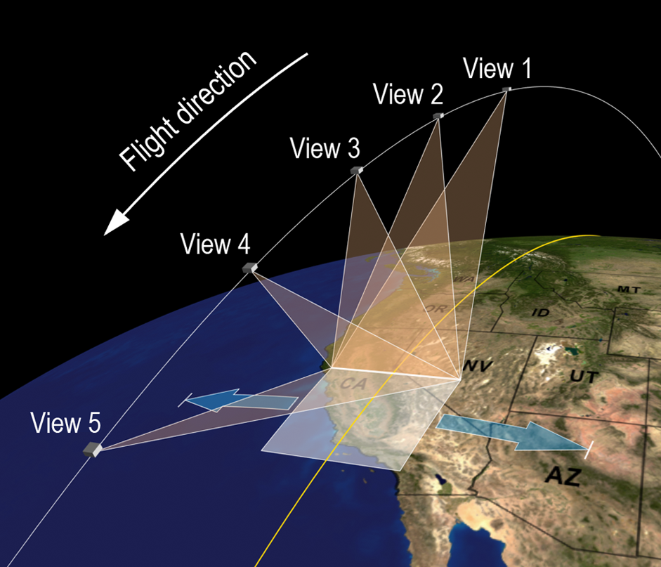
To investigate the health effects of particulate matter, the MAIA instrument will collect observations from a set of primary target areas (PTAs); current plans include 11 candidate PTAs on 5 continents (Figure 2). Each area is at least 300 × 300 km (substantially larger than a typical metropolitan area), with the exact dimensions dependent on the orbit altitude of the host platform. Each PTA will be visited on average at least 3 times per week during the 3-year period of on-orbit operations, with more frequent revisits and the feasibility of >1 acquisition per day depending on the orbit altitude and inclination. The candidate PTAs have been chosen to (1) include major population centers covering a range of particulate matter concentrations and particle types, (2) contain surface-based sun photometers to help ensure accurate retrievals of aerosol properties, (3) include ground-based particulate matter–size discrimination and chemical speciation monitors, and (4) enable access to geocoded health data sets. The fine spatial resolutions of the MAIA instrument (<300 m) and its derived data products (∼1 km) are designed to capture data on community-scale characteristics of particulate matter composition. Combined with comprehensive coverage, the derived particulate matter concentrations in these PTAs will be linked to various health records to establish the particle types for which (1) maternal exposure is associated with adverse birth outcomes, such as restricted intrauterine growth, preterm delivery, and low birthweight; (2) short-term exposure (daily to monthly) is associated with respiratory illness, such as asthma and premature death; and (3) chronic exposure (multiyear) is associated with cardiovascular and respiratory disease.
Worldwide distribution of primary target areas of the National Aeronautics and Space Administration’s Multi-Angle Imager for Aerosols. Orange boxes indicate targets devoted to studying short-term particulate matter exposure, while pink boxes are aimed at chronic effects. Some target areas satisfy both objectives.
In addition to repeated observations of the PTAs, MAIA will collect aerosol and cloud observations from targets of interest to the radiation science, climate, and environmental science communities—such as major aerosol source regions and cloud regimes affected by aerosol pollution, as well as episodic targets of opportunity (eg, large wildfires, dust storms, or volcanic eruptions).
In keeping with NASA’s data policy, MAIA’s data on aerosols and particulate matter will be publicly available and free of charge to researchers interested in using them. Once the mission begins routine operations, a lag of about 2 days is anticipated between the time of observation and the availability of derived products. Although this lag is too long to affect near-real-time air quality forecasts, the data will be useful for retrospectively evaluating the accuracy of forecast models. Demonstration of the technologies of the MAIA instrument and the integrated approach of coupling the measurements with models of chemical transport and geostatistics will clear a path to future instruments that would extend the coverage to the entire globe and that could pave the way toward a data pipeline that would enable shorter turnaround times for the delivered data products.
The MAIA instrument, to be built by NASA’s Jet Propulsion Laboratory, incorporates advanced and comprehensive methodologies for measuring aerosol properties from space. Although other current and planned NASA and non-NASA instruments are highly skilled at acquiring aerosol information, they do not match the range of measurement characteristics, degree of accuracy, and spatial resolution required to meet MAIA’s scientific objectives. To help ensure that these objectives are met, an interdisciplinary team has been assembled comprising researchers and policy specialists from NASA and several universities with expertise in remote sensing, aerosol science, air quality, epidemiology, and public health. Additionally, the MAIA investigation takes the novel approach of including, from the very beginning, collaborators from EPA, National Institutes of Health, Centers for Disease Control and Prevention, National Oceanic and Atmospheric Administration, and World Health Organization. As NASA’s first competitively selected satellite investigation with societal benefit as its primary objective, MAIA offers the potential of not only implementing a highly cost-effective strategy for monitoring particulate matter composition but also pioneering new ways to improve public health around the world.
Footnotes
Acknowledgments
This commentary is dedicated to the memory of our valued colleague, Molly Macauley, PhD, who was vice president for research at Resources for the Future. Molly was a strong and highly respected advocate of using satellite remote sensing to benefit society. Her untimely death in July 2016 is a tragic and incomprehensible loss.
Declaration of Conflicting Interests
The author(s) declared no potential conflicts of interest with respect to the research, authorship, and/or publication of this article.
Funding
The author(s) disclosed receipt of the following financial support for the research, authorship, and/or publication of this article: Part of this work was carried out at the California Institute of Technology, Jet Propulsion Laboratory, under contract with NASA.