
Abstract
Metrics of hydrological mimicry (‘mimetrics’) reflect similarity in ecological structure and/or functions between managed and natural ecosystems. Only the land-surface parts of hydrological cycles are directly visible and represented in local knowledge and water-related legislation. Human impacts on water cycles (HIWC) can, beyond climate change, arise through effects on local and regional hydrological processes, from both reduced and increased water use compared to a natural reference vegetation with which landscape structure and hydrology are aligned. Precipitationsheds, the oceanic and terrestrial origin of rainfall, depend on evapotranspiration and thus on vegetation. The political commitment to reduce agricultural impact on nature requires hydrological mimetrics to trickle down through institutions to actions. Existing metrics do not suffice. For example, the water footprint metric that relates agricultural water use to consumption decisions, suggests minimizing water use is best, ignoring full hydrological impacts. We explore principles, criteria and indicators for understanding HIWC, via modified evapotranspiration, effects on streamflow (downstream impacts) and atmospheric fluxes and precipitation (downwind impacts). Comprehensive HIWC mimetrics for a set of pantropical watersheds suggest hydrological mimicry options for forest-derived land use patterns through intermediate densities of trees with diversity in rooting depth and water use, interacting with soils, crops and livestock.
Keywords
Introduction
Maintaining hydrological functions and cycles is essential for meeting the sustainable development goals at the intersection of water, energy, food and income (van Noordwijk et al., 2018). Increased water demand and overexploitation of limited freshwater resources leads to water scarcity, and in many places around the world, to conflicts over water. Yet, current human domination of the global water cycle beyond water allocation issues is absent from widely used depictions and perceptions (Abbot et al., 2019a). Water cycles connect vegetation, soils, landscapes, geomorphology, and climate to human appropriation of resources, which is driven by a growing population, consumption patterns and lifestyles (Mekonnen and Hoekstra, 2011; Flörke et al., 2018; Hoekstra, 2019). Water scarcity implies that the combination of timing, place, and water quality on the planet does not match human demand, while the global amount of available renewable freshwater may yet be adequate. Rather than as a hydrologic constraint, ‘agricultural economic water scarcity’ has been defined as a lack of irrigation due to limited institutional and economic capacity to get the right quality of water to the desired places at the right time (Rosa et al., 2020). However, beyond engineering costly canals, reservoirs and pipes (Gohari et al., 2013) to overcome hydrologic constraints, solutions are needed to reduce the ongoing human impact on the water cycle (HIWC). Water availability in large parts of the tropics depends on ‘water towers’ (defined in Dewi et al. (2017) as humid upper watersheds with drier downstream areas) generating river flow and through the atmosphere (as ‘flying rivers’, streaming atmospheric moisture; Schwarzer, 2021). Caps to the monthly river water flows that can be allocated to human uses are needed to ensure that water appropriation for human uses remains within ecological boundaries, earmarking sufficient water for aquatic subsystems (Hogeboom et al., 2020). However, river flows (‘blue water’) represent only about one-third of total rainfall over land, with the other two-thirds used in situ by direct evaporation and transpiration by vegetation (‘green water’; Stoy et al. 2019). The continued availability of atmospheric water vapour as the source of precipitation (‘rainbow water’) cannot be taken for granted (van Noordwijk et al., 2014a; Creed and van Noordwijk, 2018). Beyond issues of allocation of river water, the full hydrological cycle and its functions needs to be first understood and then managed (Abbott et al., 2019b). Additional metrics are needed (van Noordwijk et al., 2016).
The classification Meadows (1999) developed of ways to intervene in a complex adaptive social-ecological system can be of use here. It ranks parameters (‘system-state data’), feedbacks (relationships, impacts), institutions (rules of and roles in the game) and goals as having an increasingly ‘transformative’ impact on a social-ecological system. The most profound changes are at goal level: beyond farmer income and societal food supply, reducing negative impacts on biodiversity and climate are goals for agricultural land use, since they were accepted as high-level sustainable development goals. To trickle down through institutions to actions, political commitments to reduce the impacts of agricultural land and water use on nature will require appropriate metrics of hydrological impacts, followed by norms, standards, regulation, incentives, monitoring and evaluation. As these metrics for minimizing negative feedback can reflect a degree of ‘mimicry’ of nature, we propose to call them ‘
In the context of this Special Issue on biomimicry and nature-based solutions for agricultural issues of concern, we set out to explore the contributions various metrics can make to support public awareness of human influence on the hydrological cycle and the ways it can be reduced. Our specific questions for this ‘perspective’ piece are:
How are human impacts on water cycles related to the types (colours) of water across spatial and temporal scales? What has been the primary appeal and use of existing mimetrics? What metric could best represent human impact on water cycles across spatial and/or temporal scales? How do proposed mimetrics relate to the diversity of issues identified in a pantropical set of forest-water-people landscapes?
We reviewed the literature and identified relevant current debates, without claiming the comprehensiveness of a formal systematic review of the literature.
Human appropriation of water cycles
Global climate change
The latest synthesis of predicted effects of global climate change on rainfall for a 2°C global warming scenario (IPCC 2021) suggests a reduction of annual rainfall by 10−20% over oceans and Mediterranean regions, and an increase in rainfall at low and very high latitudes. For a 4°C warming scenario, equatorial parts of Africa may expect stronger increases in precipitation, but the Amazon region would face a pronounced drying effect. Overall, ocean-land-atmosphere patterns are complex and dependent on the specific models used. Most models have been, implicitly, calibrated on the land cover that existed at the time of data collection, and the more land and water use patterns deviate from that reference, the less certain are the model predictions. Generally, warmer oceans will allow an increased intensity of the hydrological cycle (increasing oceanic evaporation, terrestrial rainfall and evapotranspiration), but interactions with land cover and global circulation are still inadequately represented in current models (Ayanlade et al., 2018; Dunning et al., 2018; Duku and Hein, 2021).
Human impact on water cycles
Human appropriation of net primary production (HANPP) provides a metric for the degree to which humans have modified photosynthesis of the world's vegetation, as proposed by Vitousek et al. (1986), and subsequently applied to reflect impacts of global biomass trade (Haberl et al., 2009; Erb et al., 2009). As photosynthesis is, via stomatal exchange with the atmosphere, linked to evapotranspiration, and the biomass produced and transported contains nutrients, HANPP has direct consequences for (global) water and nutrient cycles. HANPP has two components: (1) harvest of biomass in ecosystems (NPPh), and (2) productivity changes resulting from land conversion (ΔNPPLC). HANPP, defined as the sum of ΔNPPLC and NPPh in any given territory, is indicative of the intensity with which humans use the land, potentially with direct consequences for water use and cycling. The parallel concept of human impact on water cycles (HIWC), however, has not explicitly and comprehensively been discussed as yet (Figure 1).
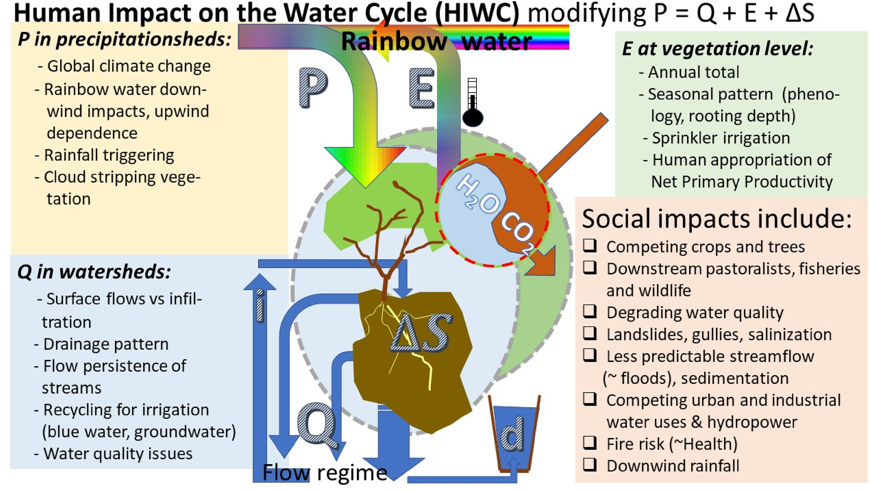
Various aspects of human appropriation of the water cycle in its blue, green, grey and rainbow water components (modified from van Noordwijk et al., 2016); P = precipitation; Q = river discharge; E = evapotranspiration; ΔS = change in soil water; I = irrigation; d = domestic and drinking water.
Water footprints
Water footprint (WF) as a metric of the evapotranspiration involved per unit product, can inform consumers about the pressure on (presumably) scarce water resources created by their respective choices. WF is defined as ETc/H, where ETc is the crop’s evapotranspiration and H the volume of harvested products, with additional terms for transport, processing and water pollution. WF estimates are based on ‘virtual water’ transfers associated with trade and consumption of (mostly forest and agricultural) products. The relative simplicity and universal applicability of the metric are its strengths. Yet, various footprint metrics need to be understood before they can be aggregated to model the overall environmental impacts of a single consumption decision (Vanham et al., 2019) or a country's import portfolio (van Oel et al., 2009). Vanham and Leip (2020) concluded that water use (footprint) and water stress (impact) are only weakly correlated, with water use more easily assessed than the water stress to which it potentially contributes. By only looking at water footprints (normalizing water use for crop production), local contexts (e.g. in relation to scarcity or abundance of water) of water are not adequately considered (van Oel et al., 2019, Vos et al., 2019), nor are the downstream and downwind impacts of water use. In a recent discussion, issues around the allocation (‘slicing the cake’) of green and blue water (assuming unchanged rainfall amounts), were contrasted with land use impacts on the intensity of the hydrological cycle via rainfall recycling (‘sizing the cake’) (Schyns et al., 2019a, van Noordwijk and Ellison, 2019, Schyns et al., 2019b). Moisture recycling may be key to assessing hydrological impacts of land cover changes, but it is a secondary issue when quantifying water allocation to competing demands.
Forests and rainfall
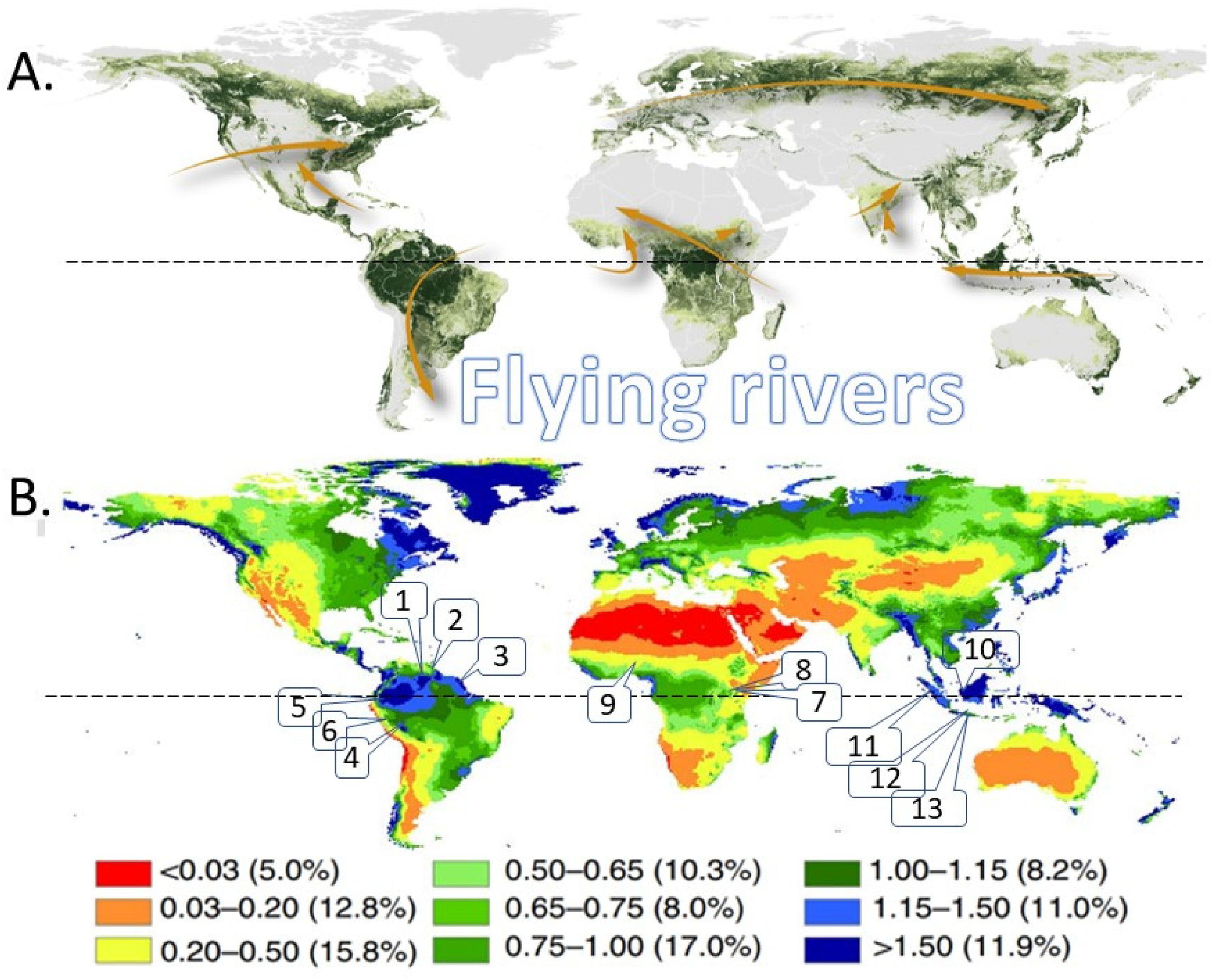
Forests have been associated with rainfall since at least the classical Greek era (Creed and van Noordwijk, 2018). Concerns that deforestation and conversion to agriculture in the Amazon basin will affect rainfall elsewhere are longstanding (Salati et al., 1981; Nobre et al., 1991). Globally at least 40% of rainfall over land is derived from terrestrial evapotranspiration, rather than from oceans (Ellison et al., 2017, 2019), and Trenberth et al. (2011) estimated this was around 65%. There is increasing recognition that the intensity of the hydrological cycle, and its influence on the percentage of recycling, is itself influenced by land cover change, especially in the case of ‘flying rivers’ (Figure 2A; Schwarzer, 2021). Where the WF may suggest that reduced evapotranspiration is always desirable (as it saves water for other uses), breaking the chain of rainfall →evapotranspiration → rainfall … can reduce rainfall downwind. The most effective ‘flying rivers’, such as those above the Amazon basin, operate at P/Epot ratios of around 1.0 (Figure 2B): higher rainfall amounts (e.g. induced by a mountain range in the dominant direction of atmospheric circulation) cannot be recycled to the atmosphere and becomes river discharge, while lower rainfall leaves some recycling capacity underutilized.
The mean residence time of atmospheric moisture, around nine days, is remarkably stable across locations and seasons (van der Ent and Tuinenburg, 2017), but the distances involved in the cycle depend on the windspeed in the relevant atmospheric layer (in the 1–100 m/s range) (Ellison et al., 2019). Low windspeeds over humid tropical forests support local rainfall recycling. Where the main rivers flow in opposite direction of the flying river, atmospheric recirculation is supported, especially where extensive floodplains and wetlands give rise to high evapotranspiration rates of the natural vegetation. A recent study of summer rainfall in the central United States (Hu et al., 2021) clarified that rainfall recycling through land–atmosphere interactions contributed 30 to 70% to warm-season precipitation in gentle (night-time) rains, while high intensity afternoon storms are of direct oceanic origin.
Potential versus actual evapotranspiration
Where forests, especially evergreen ones with a high leaf area index throughout the year, are replaced by other vegetation, evapotranspiration on an annual basis will be reduced – and so will rainfall recycling. Blue water flows to downstream areas may increase, while downwind flying rivers may dry up. Across large data sets, forests tend to operate in the Eact/Epot range of 0.8–1.1 (Creed and van Noordwijk, 2018). Once crops have reached a closed canopy stage, their Eact/Epot may be similar to that of forests, but their ability to secure water from deeper soil layers in dry periods is often reduced due to shallower rooting. In young and maturing crop stages water use is lower – causing the Eact/Epot ratio for crops and grassland on an annual basis to be 0.2–0.3 lower (Creed and van Noordwijk, 2018). A first target for ‘hydrological mimicry’ may thus be that the Eact/Epot ratio of agriculture/forestry land uses does not differ much from that of the natural vegetation it replaces, e.g. by adding deep-rooted tree rows surrounding fields. Open questions are the temporal and spatial scales at which this criterion needs to be applied (see below). A recent study of evapotranspiration as influenced by land use change in the Lake Naivasha Basin in Kenya (Odongo et al., 2019) found that conversion from grassland to cropland increased plot-level ET by up to 12% while conversion from cropland back to grasslands (abandonment) reduced ET by ∼4%. However, at basin scale the annual ET declined over 10 years from 724 mm to 650 mm (∼10%), as cloud cover reduced net radiation, and air humidity increased, while the surface-air temperature difference decreased.
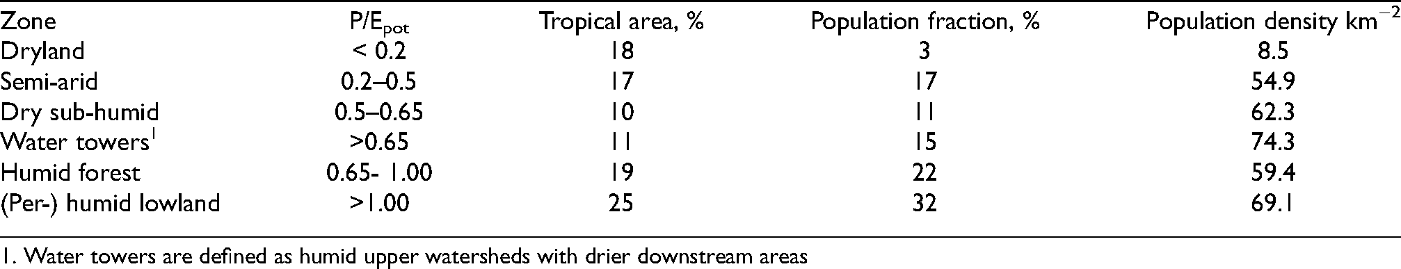
1. Water towers are defined as humid upper watersheds with drier downstream areas
Consequences of reduced evapotranspiration
The reduced ET outside the cropping season may increase the perceived need to drain the fields and landscape, especially where access by heavy machinery constrains planting time (van Noordwijk and de Willigen, 1987). In the early growth stages of annual crops, the impacts of reduced vegetation cover on increased erosion, sediment transport and nutrient redistribution in landscapes is well-studied and part of what ‘ecological mimic’ forms of agriculture try to avoid, e.g. by maintaining a permanent litter layer in agroforestry systems (Hairiah et al., 2006) or through reduced tillage.
In specific settings, reduced Eact/Epot ratios of agricultural crops can increase groundwater flows that bring saline layers into circulation, as shown in the ‘dryland salinity’ context of S and W Australia (Clarke et al., 2002, Lambers, 2003). In drier climates, dryland salinity can also be caused by surface water flows (Callow et al., 2020), with tree planting to increase Eact/Epot ratios as a remedy (Schofield, 1992, Pannell and Ewing, 2006). Similar issues have been discussed for the Dry Chaco ecological zone in Argentina (Marchesini et al., 2017). However, there are also opposite effects reported where tree planting reduces fresh groundwater flows and increases salt accumulation (Jobbágy and Jackson, 2004). Much will depend on where in the landscape salt deposits are located, and what types of water flow disturbances can bring them into circulation. It is expected that the change in the Eact/Epot ratio relative to native vegetation is the primary driver (Nosetto et al., 2012).
In landscapes with other geological histories and subsoil characteristics, clearing vegetation or reducing vegetation cover, e.g. by high grazing pressures, can lead to ‘harvesting’ of either surface water or groundwater flows. While this can support downstream water use, there are also risks. In the Nyando basin in Western Kenya, deep gullies have emerged in cropped landscapes, destroying houses, roads and cropped fields. While the initial explanations focused inadequate soil management (deGraffenried and Shepherd, 2009), subsequent analysis suggested that the cause of the additional groundwater flows was higher up in the landscape (Gathenya et al., 2011; Olang and Fürst, 2011). In the Sant Luis landscape in Argentina replacement of native vegetation by soybean with its lower ET led to additional groundwater flows, serious gully erosion and the emergence of a new river (Río Nuevo; Guardian, 2018).
Flow regimes with reduced buffering
Changes in flow regimes due to modified water uptake interact with changes in the fraction of rainfall that becomes overland flow. Higher peak flows and lower base flow rates are often observed as a consequence of the conversion of forests to agricultural landscapes. This trend is exacerbated where agricultural landscapes become urbanized, with larger fractions of the surface area ‘sealed’ and roads acting as drainage channels during peak rainfall events. A metric that captures these changes across the full spectrum of land uses is flow persistence, where a value of 1.0 indicates perfectly stable flows, and a value of zero the direct transmission of rainfall to streamflow (van Noordwijk et al., 2017a). High flow rates tend to erode banks of streams and rivers and may dominate net sediment loss rates at subcatchment scale, rather than field-level erosion (Verbist et al., 2010).
Grey water
Agricultural, industrial and domestic use of water will in part lead to evapotranspiration, and in part to water returning to surface and groundwater flows in modified quality. Addition of organic substances can lead to ‘self-cleaning’ responses by aquatic biota, but time and dilution are needed before water quality meets standards for subsequent users. Impacts of agriculture and food systems on water quality by organic pollutants and nutrient addition depend on scale. Efficiency gaps prevail at societal scale where nutrient cycles are broken and crop and feed production depend on fertilizer while the nutrients harvested with products accumulate elsewhere in undesirable locations (van Noordwijk and Brussaard, 2014). Grey water impacts are part of water footprints via the degree of dilution with ‘blue’ water needed to obtain acceptable concentrations for the blue and green water used but not evaporated.
Water footprint appeal and challenges
Conceptually, WF adds up the three types of water use (green, blue and grey) to make global comparisons, but without considering different degrees of water scarcity across the globe. Similar to the way HANPP and carbon exchange between land and atmosphere are handled (Figure 3A), the WF is focused on vertical exchanges.
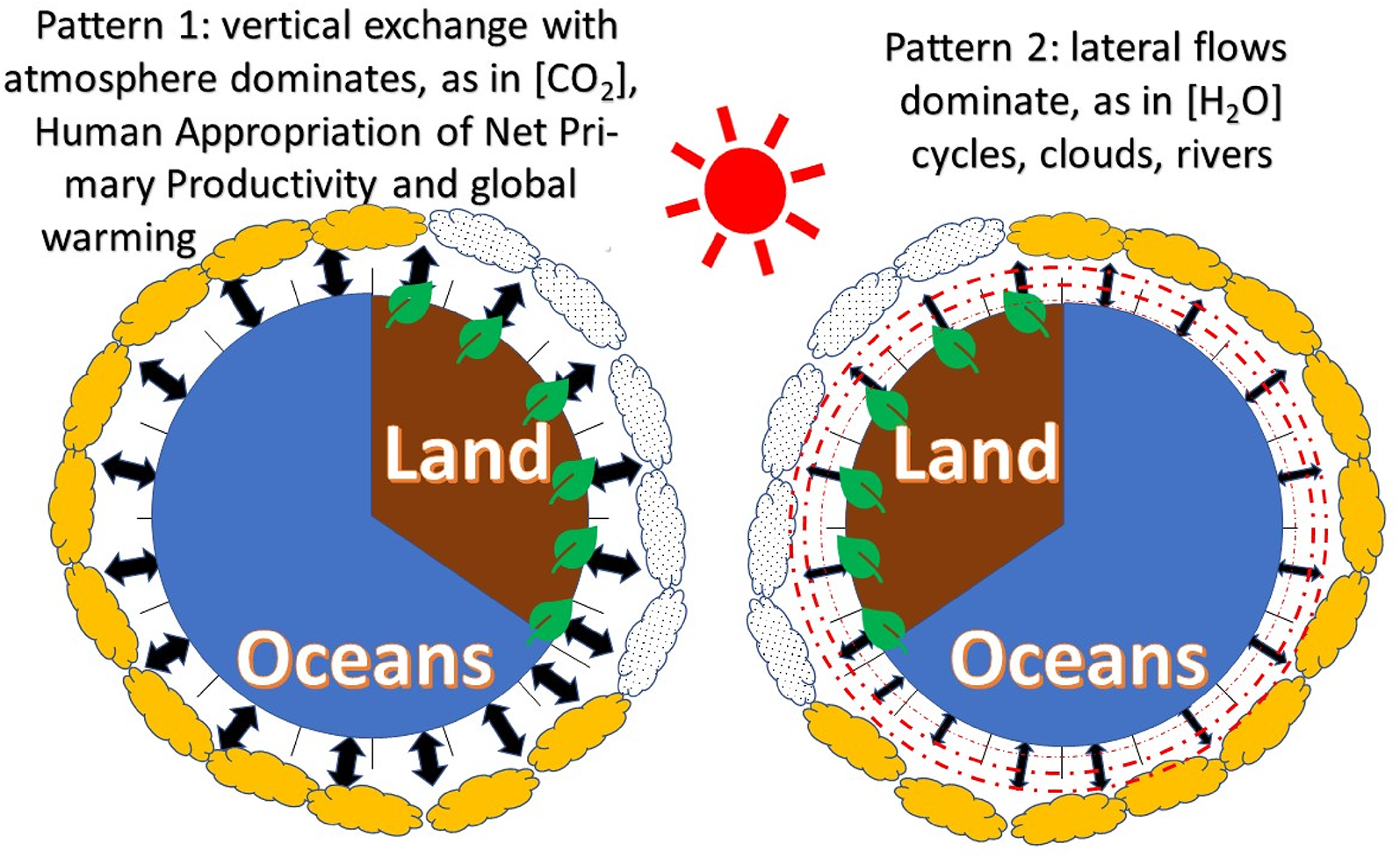
Two Perspectives on interactions between land, ocean and atmosphere as part of the planetary system: A. Focused on vertical exchanges with the atmosphere, B. Emphasizing lateral flows, and thus an overriding importance of location on the globe.
WF studies emphasize that the globalization of water (virtual water transfers) implies international trade from one place to another. Yet, these studies largely ignore horizontal physical water flows (over land and through the atmosphere) due to oversimplified hydrological models. In contrast (Figure 3B), hydrological studies focus on lateral (horizontal) flows of surface and groundwater (blue water) and atmospheric moisture (rainbow water). In this perspective, location matters for any assessment of human resource appropriation. Thus, it is important to translate virtual water transfers into physical water impacts. In a critique of WF and associated planetary boundary concepts for freshwater, Heistermann (2017) challenged: “While the bio-physical impacts of excessive water consumption are typically confined to the river basin scale, the planetary boundary proponents argue that water-induced environmental disasters could build up to planetary-scale feedbacks and system failures. So far, however, no evidence has been presented to corroborate that hypothesis”, and “the exercise of assigning actual numbers to such a boundary is arbitrary, premature, and misleading. Taken as a basis for water-related policy and management decisions, though, the idea transforms from misleading to dangerous, as it implies that we can globally offset water-related environmental impacts. A planetary boundary on freshwater use should thus be disapproved and actively refuted by the hydrological and water resources community”. Before we can define locally relevant boundaries, we need a more comprehensive set of metrics.
A review of WF by Jeswani and Azapagic (2011) commented on the huge variation in the results between different methods and on the need for a standardized methodology for assessing the impacts of water use on a life cycle basis. Standardization of the methodology has been attempted by Hoekstra et al. (2011), but new aspects have continued to be incorporated. As was also found for the carbon footprint of bioenergy crops, for example (Davis et al., 2013), the ‘management swing potential’ or degree to which the footprint depends on the specific choices made about the multiple ways of producing a single commodity can be substantial and comparable to the average per commodity footprint. For example, a study of the WF of printing and writing paper (Van Oel and Hoekstra, 2012) estimated results to vary between 300 and 2600 m3 /t, depending on reported paper-recovery rates for different countries. “The water footprint concept is integrative by nature by its applicability at different levels (local to global) and along supply chains (from investment and production to processing, sales, and consumption). The full potential of water footprint analysis along supply chains needs to be realized still, though. A relevant question is how local-scale actions (e.g. crop choice or water use efficiency increase) together can contribute to the solution of problems at higher levels (e.g. water scarcity at basin level or international burden shifting through trade) and how global actions (e.g. international agreements on sustainable trade) can contribute to the solution of local water problems” (Hoekstra et al., 2017).
As an example of footprint results, the global average WF of paddy rice in the period 2000−2004, was 1325 m3 /ton (48% green, 44% blue, and 8% grey water; Chapagain and Hoekstra, 2011). The WF initially only accounted for evapotranspiration (‘water use’) but subsequently efforts were made to include, as in a life cycle assessment (LCA), both consumptive and degradative water use. The latter can be made comparable with the former with the critical dilution volume approach, calculating the water volume needed to dilute polluted grey water to environmentally acceptable standards (Ridoutt and Pfister, 2013). A review of 96 scientific articles on the WF indicator of agricultural production, documented a shift of focus from assessing products’ water trade on a global scale, to the rigorous quantification of the three components (blue, green and grey water in nearly half of the studies) for specific crops and in specific geographical areas (Lovarelli et al., 2016). Further applications referred to the WF of an increasing share of bio-energy in energy supply Gerbens-Leenes et al. (2009) and the pressure on freshwater resources due to terrestrial feed ingredients for aquaculture production (Pahlow et al., 2015).
The average WF per person in the period 1996–2005 was estimated by Hoekstra and Mekonnen (2012) to be 1385 m3/y (2842 m3/y, 1071 and 1089 m3/y for citizens of the USA, China and India, respectively). Agricultural production contributed to 92% of the footprint, with 74% green, 11% blue, and 15% grey water. About one-fifth of the global WF relates to production for export. Ercin and Hoekstra (2014) concluded that reducing the WF to a sustainable level by 2050 is possible, provided that human consumption patterns change towards more plant-based diets.
Proposed mimetrics for human impacts on water cycles
Human appropriation of water resources impacts the global water cycle and has consequences for a range of ‘watershed functions’ (van Noordwijk et al., 2016) in reference to pre-human natural vegetation (Figure 4).
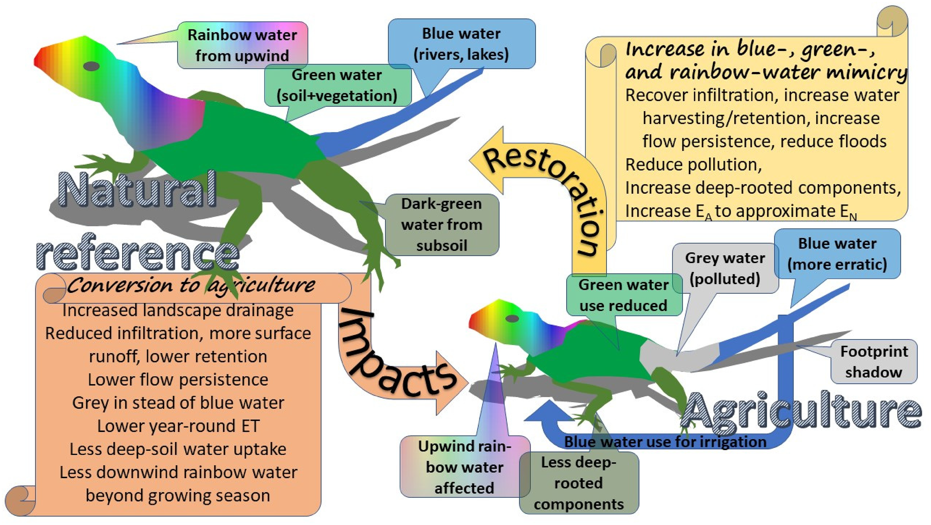
Conceptual representation of hydrological mimicry with the relationships between the colours of water in a natural reference situation as basis for describing changes in elements of the water balance equation, and suggesting targets for restoration of hydrological functions.
The water balance equation at watershed scale can be developed by aggregation across different zones (e.g. upper, middle and lower watershed; Figure 5), with the conventional emphasis on upstream-downstream relations in surface and groundwater flows augmented by the upwind-downwind relations in atmospheric moisture transfers, and affecting the range ‘watershed functions’ (Table 1).
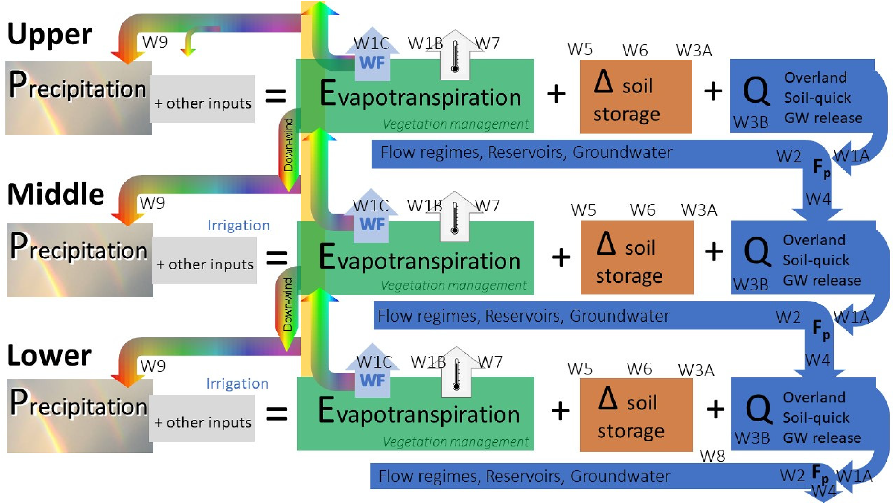
Schematic representation of the colours of water at a basin-scale water balance (based on upper, middle and lower zones) and the various watershed functions (W1…W9; van Noordwijk et al., 2016; see table 1) that are hydrologically connected in downstream and downwind directions.
Watershed functions nand metrics that can indicate disturbance of hydrological functions as a consequence of human impacts on water cycles.
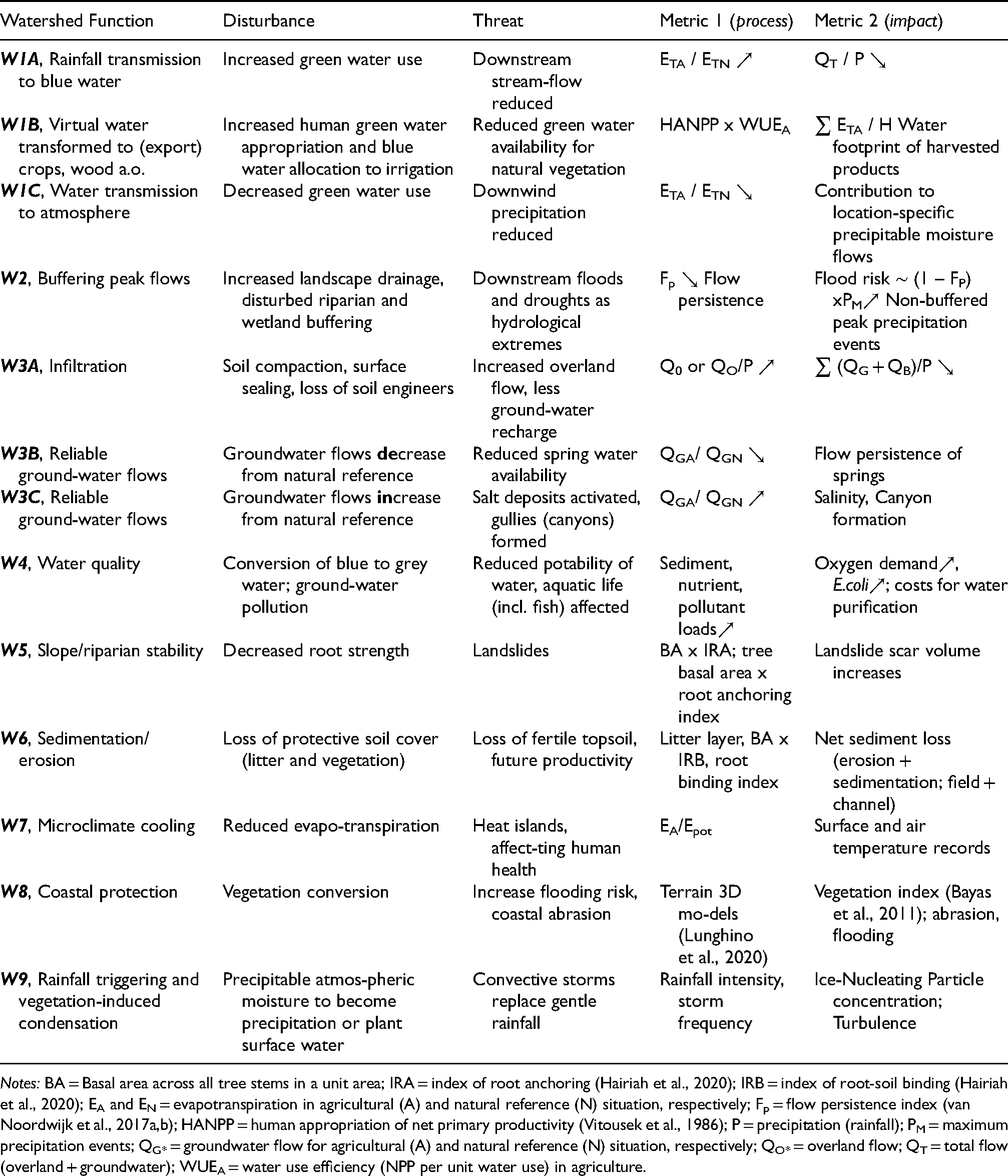
Notes: BA = Basal area across all tree stems in a unit area; IRA = index of root anchoring (Hairiah et al., 2020); IRB = index of root-soil binding (Hairiah et al., 2020); EA and EN = evapotranspiration in agricultural (A) and natural reference (N) situation, respectively; Fp = flow persistence index (van Noordwijk et al., 2017a,b); HANPP = human appropriation of net primary productivity (Vitousek et al., 1986); P = precipitation (rainfall); PM = maximum precipitation events; QG* = groundwater flow for agricultural (A) and natural reference (N) situation, respectively; QO* = overland flow; QT = total flow (overland + groundwater); WUEA = water use efficiency (NPP per unit water use) in agriculture.
Internally consistent estimates of parameters in Table 1 can be generated using one of several hydrological models sensitive to land use change in terms of vegetation, impacts on soil physical conditions and regional climates. The Generic River Flow (GenRiver) Model (van Noordwijk et al., 2017b) is a distributed process-based model that transforms plot-level water balances to landscape scale. Beyond the estimates for water transmission, buffering peak flow and infiltration (W1 – W3A) of the current model version (https://www.worldagroforestry.org/output/genriver-generic-river-model-river-flow), an updated version (β-tested) has groundwater parameters to accommodate the functions W3B and W3C (Khasanah et al., 2021). Further steps link flow persistence Fp and overland flow to slope/riparian stability (W5) and soil erosion/sedimentation (W6). Species-level data for indices of tree root anchoring and soil binding (Hairiah et al., 2020) can compare vegetation-level estimates for forests and derived vegetation on slopes to estimate landslide risks.
Application in a set of tropical watersheds
Ongoing efforts to understand the forest-water-people interactions in a pantropical set of landscapes cover a wide range of human population densities, ecoclimatic zones and landscape positions (Van Noordwijk et al., 2020; Table 2). They relate diagnostic studies of human disturbances of hydrological cycles to a shared understanding between stakeholders of how such impacts relate to land and water use practices, and what can be done (at scenario level) to reduce the pressures. For the scenario studies, ‘serious games’, i.e. games developed and used primarily for serious purposes as opposed to entertainment (Speelman et al., 2018), are in development that can link actor decisions to metrics of human impacts and consequences for other stakeholders. Within this portfolio of landscapes, the following examples of hydrological mimicry can be explored.
Characteristics of a set of pan-tropical forest-water-people landscapes (van Noordwijk et al. 2020) in relation to the watershed functions (W1…W9, see table 1) at stake in response to changing current land and water use; I = important; r = relevant; site numbers refer to the map in Figure 2.
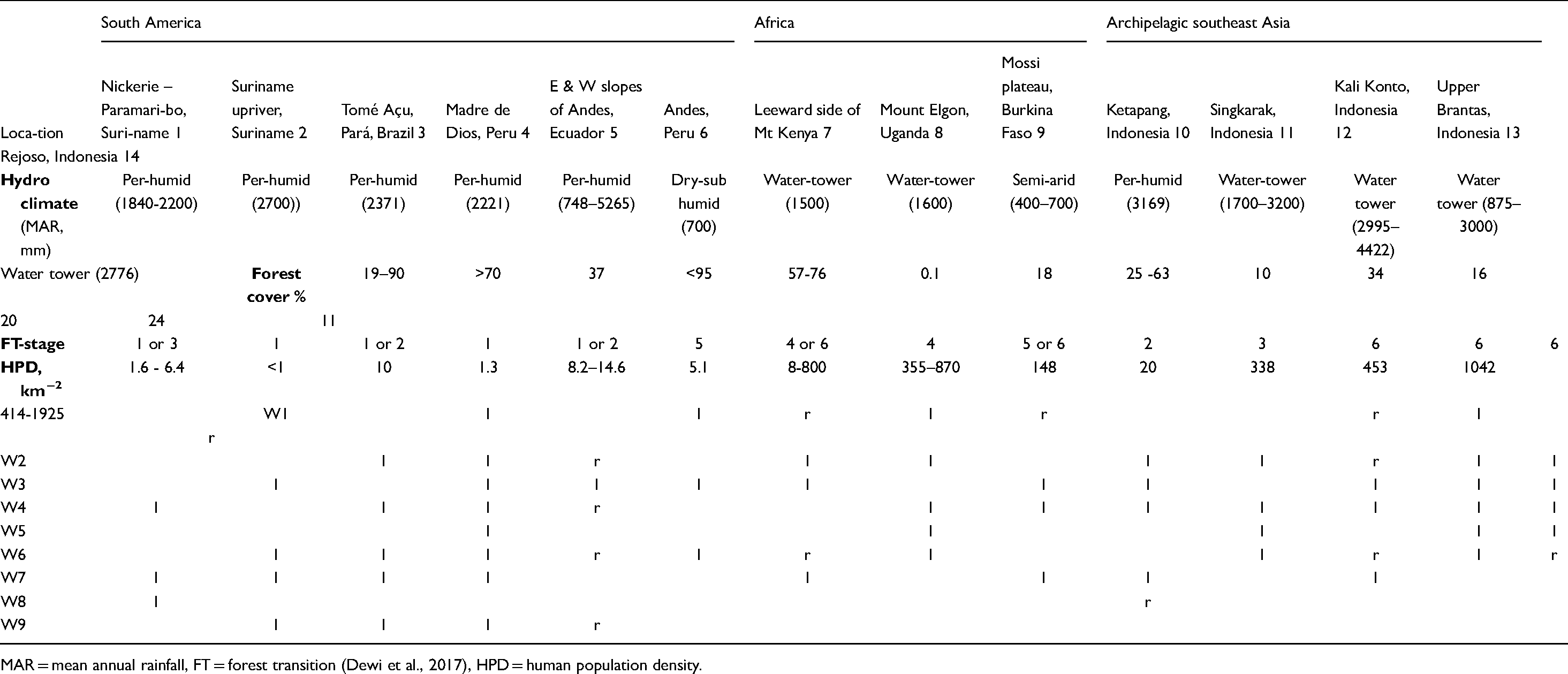
MAR = mean annual rainfall, FT = forest transition (Dewi et al., 2017), HPD = human population density.
Aspects of green water mimicry
Tree cover transitions (W1a)
Forest or tree cover transitions (Dewi et al., 2017) have hydrological consequences first of all for green water use by the modified vegetation, followed by impacts on infiltration and landscape drainage that affect blue water flow regimes and water quality. Rainforests typically have a high Leaf Area Index, with high rainfall interception in the canopy followed by direct evaporation, a permanent litter layer protecting the soil and a diversity in rooting depths that allows green water use to be buffered during dry periods. Forest conversion to croplands or (degrading) pastures reduces green water use, but conversion to tree crops such as oil palm (either as monoculture or mixed agroforestry system) is expected to return ETA / ETN to its natural vegetation value (Röll et al., 2015, 2019, Hardanto et al., 2017), or even increase it where irrigation is used in dry periods (Brum et al., 2021). For potentially cropped area in sub-Saharan Africa, the average rootable depth allows for maintaining an EACT of 3 mm day−1 for 25 days (Leenaars et al., 2018). However, the rootable volume was reduced for maize by a third due to soil conditions that local trees can be adapted to (van Noordwijk et al., 2015). Adding locally adapted trees in agroforestry systems can increase hydrological mimicry on soils where crop rooting depth is restricted. Green water mimicry may be optimal in mixed agroforestry land uses, while plantations of fast-growing trees or irrigated crops exceed the ETA / ETN norm. Restoration of traditional water harvesting structures in India has increased infiltration, local groundwater flows and green water use, but reducing blue water yield for downstream reservoirs (Singh et al., 2009). Where such reservoirs were developed in an already degraded landscape, there may be a challenge in determining what can be used as a ‘natural reference’.
Virtual water (W1b)
Vegetable and flower production on the middle and lower slopes of water towers in East Africa targets export markets. It uses river water and reduces water availability downstream for pastoralists and wildlife in ‘endorheic’ catchments that use all incoming water and do not have an outlet to the sea. For such situations the virtual water or WF metric (W1B) has direct relevance.
Aspects of blue water mimicry
Water towers (W1a)
An analysis of nine mountains in East Africa considered to be forested water towers (Wamucii et al., 2021) found that most areas inside and outside the water towers are under pressure from human activity. So far, however, water yield is likely more sensitive to climate change than to land-use change within the (protected) water towers. Future water yield is likely to experience more extreme variations than those observed so far.
Surface water flows (W2, W3a):
The Amazon in Morona Santiago (Ecuador) has a ‘dry’ season that lasts around 4 months with 100 to 200 mm of monthly precipitation. Water-share conflicts for agriculture are not common in this zone. In the Andean Choco in Ecuador, water use conflicts involve livestock producers. In Kali Konto, Indonesia, upper parts of watersheds with steep slopes well-protected by grass strips provide fodder carried to livestock in the villages. Erosion along the paths used for motorbike-based transport of grass, combines with that from intensively cropped middle slopes (Andriyanto et al., 2015) and cattle excreta dumped into the river, worsening water quality in the Selorejo reservoir (Ambong and Sayekti, 2018).
Groundwater flows (W3b, W3c)
Groundwater over-use in lowlands is the main reason artesian spring discharge declines in the Rejoso watershed in Indonesia (Khasanah et al., 2021). Tree cover as a predictor of infiltration with thresholds differing between elevation zones on a single mountain (Suprayogo et al., 2020) leads to an optimal intermediate tree density phenomenon, similar to what was described for the Sahelian zone (Ilstedt et al., 2016; van Noordwijk et al., 2019).
Aspects of grey water mimicry (W4,W5,W6)
Water quality in natural reference situations can range from oligo-, via meso- to eutrophic, often in relation to geology and soil forming processes. Plate tectonics uplifting mountain ranges such as the Andes and Bukit Barisan range on Sumatra and volcanic activity in Java rejuvenate soils and lead to natural processes of erosion and sedimentation, transferring soil fertility to lowlands and eutrophic wetlands, countered by locally adapted trees that thrive on volcanic ash (Ishaq et al., 2020). Human land use patterns that remove litter layers, will reduce infiltration, increase overland flow and the entrainment of soil particles. It thus accelerates natural processes of erosion (W5) and slope instability (W6) and greatly exceed sedimentation and eutrophication (W4). Collective action in managing lakes to avoid and deal with existing eutrophication and pollution requires empowerment of institutions at a relevant scale, as documented for Lake Singkarak in Indonesia (Abdurrahim et al., 2021).
Agricultural crops grown intensively, either for export or local consumption, contribute to the conversion of blue to grey water by agrochemicals (W4). Some farmers consider the forest as a reference for the implementation of agricultural practices, they mimic the strata forest structure, litter and vegetation coverage and soil management with forest microorganisms (W6).
Aspects of rainbow water mimicry
Cooling forests and trees (W7)
Cooling effects of increased ET after tree planting are well recognized in reducing the stress in urban heat islands. Explicit use of such effects in climate change adaptation of tree crops is still scarce (van Noordwijk et al., 2014b). The combined effects of evapotranspiration and albedo depend on latitude (Li et al., 2015): tropical forests have a strong cooling effect throughout the year; temperate forests a moderate cooling in summer and moderate warming in winter with net cooling annually; and boreal forests strong warming in winter and moderate cooling in summer with net warming annually. Net effects can vary within a country (Williams et al., 2021).
Recent studies show cloud cover (an additional cooling effect) to be spatially associated with tree cover, even when effects of elevation are accounted for (Teuling et al., 2017, Cerasoli et al., 2021, Duveiller et al., 2021). Vegetation with higher leaf area index and deeper roots has higher actual evapotranspiration than crops and other low vegetation with shallow roots, increasing the EA/Epot ratio. Rows of fast-growing but deep-rooted trees such as Eucalypts or Poplars can increase EA/Epot more than proportionately to the area covered, and increase hydrological mimicry for the cropped fields or pastures they surround. However, in temperate climates rows of trees as windbreaks can increase risks of night frosts (Tamang et al., 2010).
Atmospheric moisture recycling (W1c), rainfall triggering (W9)
The rainbow water and flying river considerations (van der Ent et al., 2010, Keys et al., 2016) directly apply in the Amazon basin and adjacent Guiana shield rainforests in Suriname (Bovolo et al., 2018). Boers et al. (2017) explored how trade winds in the westward cascade of precipitation and evapotranspiration across the Amazon are amplified by condensational latent heating that enhances atmospheric moisture inflow from the Atlantic ocean. The analysis aligns with ‘biotic pump’ concept (Sheil, 2018). Replacing rainforest by cropland or pasture leads, in this analysis, to increased albedo, a 20% reduction in interception and evapotranspiration and a 40% increase in sensible heat flux, reduced wind speeds, and eventually to a possible dieback of the entire ecosystem due to partial deforestation of the rainforest in the Eastern Amazon (Boers et al.,2017; Staal et al., 2018; Salazar et al., 2018, Molina et al., 2019). For vegetation replacing natural forest and possible ‘mimics’ much remains unknown. There is increasing understanding of the biological agency in ‘rainfall triggering’ and ‘induced condensation’ on plant surfaces (e.g. on mountain tops), but this is as yet poorly connected to compilations of plant functional traits (Spracklen et al., 2018)
Contrary to belief, in the south-western Amazon in Peru, where some of the rivers generate directly from the Andean glaciers, it was shown that the water flowing in the upper Madre de Dios basin mainly originates in the foothill humid forest, through recycling and evaporation, and not directly from the glacier melt (itself fed by Atlantic moisture) (Lambs et al., 2012). Understanding the water cycle at a larger scale has important implications, for example for the planning of large-scale initiatives for freshwater conservation in the Amazon, for which there is limited available data (Thieme et al., 2007), or for conservation planning of landforms created by particular fluvial dynamics (Hamilton et al., 2007). In the Andean Choco zone, farmers are convinced that precipitation and streamflow are lower than before, when most of the territory was primary forest and the first settlers arrived. The most common testimonies suggest that rain events were stronger and that rainfall has changed because of reduced forest cover (W1A/W9); they also recall that people were not able to cross the rivers that they cross easily nowadays (W2). Although both indigenous and mestizo farmers perceive that the Amazonian climate is changing, testimonies about changes in precipitation and streamflow are varied. Analysis of regional climate models suggests that changes in atmospheric water transmission may be first observed in the eastern slopes of the Andes (W1C).
Discussion
Regarding our first question we found that hydrological impacts of agriculture can reduce a wide range of functions (Table 1), with a substantial diversity of local manifestations (Table 2). As nutritionally recommended food sources such as fruits, vegetables, and dairy have a high WF (Tom et al., 2016), there appears to be a tradeoff between human health and WF in discussions on shifting human consumption patterns; however, for the ETA / ETN metric such tradeoffs depend on local reference conditions. In answer to our third question, a coherent set of mimetrics may thus be needed, rather than a single one. Minimizing the ecological footprint of food involves mimicry beyond minimizing water use.
Metrics beyond WF that include natural reference vegetation and green water use may change the perspective. The primary appeal and use of existing water footprint concepts (our second question) derive from ‘blue water’ scarcity. Blue water governance seeks to reduce conflicts between evaporative use in agriculture and forestry or industrial cooling, flow-dependent hydropower generation, and industrial and domestic use that affect water quality rather than quantity. The need to extend current blue water governance to green and atmospheric water is becoming more widely articulated (Ellison et al., 2017, 2019; Creed and van Noordwijk, 2018; te Wierik et al., 2020, 2021). Acknowledging that many aspects beyond hydrology influence human decisions on watershed management (van Noordwijk, 2019), the proposed metrics relate to a set of ‘principles’ and ‘criteria’ via the list of hydrological watershed functions. The pantropical set of sites represented in Table 2 (our fourth research question) suggests diversity of the functions and metrics that are most relevant, depending on the human population density stage of forest transition and terrain properties. The set of mimetrics proposed will require further testing and refinement. Specific, locally tailored metrics that are relevant, credible and legitimate for local stakeholders are needed for result-based environmental stewardship contracts, and especially where auctions are used to efficiently allocate scarce financial resources (Leimona et al., 2020).
The relevance of a water-function-based framework for understanding consequences of land use and for supporting resilience through governance interventions has become apparent in recent debates, especially in agriculture–forest frontiers (Zipper et al., 2020, Falkenmark and Wang-Erlandsson, 2021; Seijger et al., 2021). The asymmetric recovery responses (‘hysteresis’) of forests call for specific caution (Staal et al., 2020). Direct transfer of water legislation that makes land users accountable for the water use of plantations as developed in South Africa to countries in East Africa where water use by Eucalyptus trees has become a controversial issue, would ignore the very different positions of South and East Africa with respect to flying rivers: ETc from South Africa returns to oceans, that of East Africa feeds rainfall elsewhere on the continent (van Noordwijk et al., 2014a). Location-based diagnostics are needed, supported by understanding of long-distance effects on rainfall. Hydrological mimicry options for forest-derived land use patterns can in many landscapes include trees as part of nature-based water management, managing intermediate densities of trees with diversity in rooting depth and water use, interacting with soils, crops and livestock (van Noordwijk et al., 2019).
Mimicry can be understood at any of the four levels of the Meadows (1999) hierarchy (goals, rules and roles, feedbacks and data): mimetrics that help avoid negative externalities of unforeseen hydrological feedbacks can be embraced at a pragmatic level, given existing sustainable development goals, without suggesting that Nature is the ultimate reference group for guiding all human activities. Ongoing efforts in the SESAM program (Table 2; van Noordwijk et al., 2020) aim at linking deepened hydrological understanding of land use decisions at landscape (watershed) scales to social consequences for watershed functions, and the emergence of institutions that drive towards collective action and greater accountability.
In conclusion, a circular economy may be achievable in water before it is for nutrients, but it does require a paradigm shift that connects current climate science to land-use dynamics. The metrics we proposed here may play a role in this paradigm change. A major obstacle, however, is that only the land surface elements of hydrological cycles are directly visible and represented in local knowledge and, in many cases, in water-related legislation. Where existing rules may focus on ‘forests’ and forest conversion to agriculture, regardless of hydrology and including plantations with high water demand, better accounting of the hydrological consequences of forest quality and partial tree cover in forms of agroforestry mimicking forest mosaics, is needed. The proposed mimetrics may help in such assessment.
Footnotes
Abbreviations used
Acknowledgements
Through the SESAM (https://www.wur.nl/en/project/Scenario-Evaluation-for-Sustainable-Agro-forestry-Management-SESAM-1.htm) program Wageningen University & Research supports the various PhD-projects reflected here. Mr Schwarzer allowed us to reproduce ![]() . The manuscript benefitted from the comments by two anonymous reviewers on an earlier version.
. The manuscript benefitted from the comments by two anonymous reviewers on an earlier version.
Declaration of conflicting interests
The author(s) declared no potential conflicts of interest with respect to the research, authorship, and/or publication of this article.
Funding
The author(s) disclosed receipt of the following financial support for the research, authorship, and/or publication of this article: This work was supported by the Wageningen University (grant number INREF).